Article

Investigating the Effect of Transit-Oriented Development (TOD) on Social Equity—Examining the Displacement of Footscray, Melbourne

1
The Bartlett School of Planning, University College London, Gower Street, London WC1E 6BT, UK
2
Edinburgh College of Art, The University of Edinburgh, South Bridge, Edinburgh EH8 9YL, UK
3
The School of Global, Urban and Social Studies (GUSS), Royal Melbourne Institute of Technology, 124 La Trobe St, Melbourne, VIC 3000, Australia
4
School of Computer Science, The University of Oklahoma, 660 Parrington Oval, Norman, OK 73019-0390, USA
*
Author to whom correspondence should be addressed.
Buildings 2024, 14(3), 824; https://doi.org/10.3390/buildings14030824
Submission received: 7 January 2024 / Revised: 13 March 2024 / Accepted: 15 March 2024 / Published: 19 March 2024
(This article belongs to the Special Issue Novel Trends in Urban Planning for Building Urban Resilience)

Abstract

:
As Melbourne faces exponential population growth, the necessity for resilient urban planning strategies becomes critical. These strategies include mixed land use, density, diversity, and sustainable transportation through transit-oriented development (TOD). While TOD promises to accommodate growing populations and address environmental concerns, it also raises issues regarding its unintended consequences on poverty and inequality, notably through residential displacement and gentrification. This study investigates the impacts of TOD construction on inequality in Footscray, employing spatial analysis techniques like the hedonic price model (HPM), robust regression analysis, and Pearson correlation analysis. It aims to understand how spatial factors influence housing prices and their correlations. Additionally, the study uses observational spatial analysis via Google Street View (GSV) to examine indices such as housing development type, traffic signage, sanitation facilities, and house beautification. This approach seeks to build an evaluation framework to assess the extent of TOD street reconstruction and its impact on gentrification and displacement. The research adapts existing knowledge to create a tool for reviewing past planning decisions and assessing the fairness of TOD planning implementation. By providing assessment and guidance to mitigate the potential adverse impacts of TOD, this study contributes to the advancement of urban-planning practices, offering insights into mixed land use and effective strategies to balance economic development and social equity, thereby enhancing community resilience. Ultimately, this research deepens our understanding of the impacts of TOD on urban inequality and offers practical tools and insights for more equitable and sustainable urban development.

1. Introduction

1.1. Transit-Oriented Development: An Urban Sustainability Strategy

As urban populations expand, the imperative for sustainable urban development intensifies. Transit-oriented development (TOD) plays a crucial role in this context, offering a comprehensive strategy to improve access to goods, services, and employment through efficient public-transport systems [1]. TOD focuses on transit accessibility and promotes a sustainably built environment by integrating mixed use, density, and walkability around public-transport stations [2]. Despite its advantages, such as reduced air pollution and car dependency, TOD may introduce challenges like increased noise, vibration, and crime, potentially affecting community acceptance and quality of life [3]. The impact on displacement and justice is particularly significant in discussions on urban development.

1.2. The Australian Context: Challenges and Opportunities

In Australia, urban sprawl and congestion have led to economic, social, and environmental issues, including reduced productivity, social exclusion, and increased carbon emissions [4]. TOD emerges as a salient solution to these challenges, advocating for high-density development proximate to major transit stations to alleviate congestion and foster sustainable urban growth [5]. Although successful international TOD examples exist, its adoption in Australia has been slow. Nonetheless, the Melbourne metropolitan region has begun embracing TOD principles, as is manifest in the Policy Melbourne 2030 and the conceptualization of ‘Central Activities Districts’, ‘20 Minute Cities’, and ‘Activity Centres’ [6].

1.3. Footscray Detailed Overview

Footscray, known for its diverse community and proximity to Melbourne’s city centre, along with recent public-transport infrastructure improvements, was selected as the focus of this study. Footscray stands out due to its diverse community, its prime location close to Melbourne’s city centre and recent advances in public-transport infrastructure. The suburb’s unique characteristics make it an ideal case for examining TOD’s impact on urban neighbourhoods [7]. Following TOD implementations such as the 20-min cities scheme, activity centres, and transit cities, Footscray has seen significant changes in housing prices, demographics, and urban redevelopment. This study aims to reveal how TOD influences urban neighbourhoods in Footscray and beyond.

1.4. Research Objectives and Questions

This study explores the impact of TOD policies on redevelopment in transit station areas, employing HPM, robust regression analysis, Pearson correlation analysis, and GVS in Footscray. It aims to develop an evaluation framework for displacement and gentrification. The research questions are the following: How does TOD affect house prices, and what is its relevance to displacement? The study synthesizes evaluation-framework results for house prices and redevelopment, offering recommendations for planning-policy development.

2. Literature Review

2.1. The Role of TOD in Urban Planning

The academic definition of TOD is the development of mixed density, mixed-use housing within a pedestrian-friendly radius, with transport hubs as the core, encouraging active transport and providing more convenient access to basic services [1]. Originally, the concept of TOD was proposed by Peter Calthorpe, an American urban designer, in order to provide ideas to address suburban sprawl and to balance the development of urban centres and suburban infrastructure in the context of the new urban liberalism [8]. Specifically, TOD is an urban-development model that addresses the problems of urban sprawl and environmental issues in order to develop a compact city with sustainable communities [9]. When the TOD is built, the density of the surrounding commercial and residential areas will increase from outward to public transport stations. And land prices within the TOD service area continue to rise as the TOD is improved. More importantly, as Cruits [10] point out, a successful TOD may not only save residents’ commuting time, but also benefit the urban society, urban environment, and urban economy.
In urban planning, TOD is more about planning and comprehensive urban design strategies to achieve a sustainable, compact, and climate-resilient urban vision [9]. Therefore, it can be seen from different TOD city government documents that government policies tend to propose TOD-related policies from different planning aspects, such as housing-planning policies and transportation-planning policies, etc., to form a comprehensive transportation-oriented strategic framework with specific requirements to ensure TOD implementation [11,12]. Furthermore, as Scheurer and Porta point out, TOD can also be a strategy for generating more urban economic revenue initially [13]. Therefore, TOD is not only the development of transit facilities, but also the policies or strategies on other credentials of development that need a “multi-bench” to commence as well [14]. Policies and strategies that support TOD are given in different kinds of urban policies to determine the specific requirements and standards for the implementation of TOD in different aspects.
For example, in Charlotte, North Carolina, the infrastructure policy and living amenity strategy mentioned developing transit infrastructure and encouraging development along five major transportation corridors for the integration of transit and land use [15]. In addition, accessibility to public transportation is another thing that the government always considers, so different urban policies will provide different guidelines to ensure the accessibility of the TOD region. The Planyc housing strategies mentioned building more new housing within the 0.5-inch radius of the transit station [16]. In addition, the Portland Community Development Strategy states that community development is to be accomplished with the hope that community members can access amenities within 20 min [17]. Furthermore, the Strategic Framework of Cape Town points out that it is needed to guarantee Cape Town’s TOD Strategic Framework, which has set targets to improve access to transit by 12% by 2032, and to reduce kilometres travelled by passengers by 23% [18].
The above three examples all link the construction of TOD with accessibility and use accessibility as an indicator to manage the construction of TOD suburbs. These common characters are valuable and can be used as a reference for studying similar policies in Australia. Additionally, it can be seen that TOD is a widely implemented urban development-planning strategy [19].
Melbourne’s TOD strategy and policies are comprehensive at both metropolitan and state levels, referring to different strategic approaches to TOD implementation and expected outcomes. As Melbourne 2030 mentioned, better management of metropolitan growth [20] will concentrate urban growth areas into growth areas dominated by public transportation [21]. In the state’s PPF, it is also mentioned that the area close to the bus station should be encouraged to develop in medium and high density, and the infrastructure should be improved to create a city with TOD characteristics [22]. Melbourne, as the targeted city, has developed TOD cities by encouraging high-density development along transport routes [23]. Therefore, according to the above policies and strategies, the TOD concept plays an important role in the strategies of Melbourne and has been given the expectation bringing about more positive impacts on the future development of the city.

2.2. The Concept of Gentrification and Displacement

Gentrification describes the process by which wealthier people move into areas of lower socio-economic areas, attracting new business and improving housing, then displacing current inhabitants. The term ‘gentrification’ originally referred to a practice of the English gentry during the 19th century. They kept an inner-city flat in addition to their country home [23]. The original use of the term originated in the mid-1960s when Glass observed the changes in the inner city of London. The social and housing market in the city centre was changing as the middle class moved back from the suburbs and drove out the working class who lived there. There is still no universally accepted definition of gentrification, and research continues to try to better understand it.
The effects of gentrification are more complex than the factors that cause it. For most planners and sociologists, gentrification is a negative social problem. It displaces relatively poor, disadvantaged groups in the areas where they usually live, especially renters [24]. Gentrification thus disrupts social life and has the inevitable consequence of displacement [25]. Conversely, other commentators have praised gentrification, arguing that it can lead to urban regeneration, boost the economy of a site, and increase local property values. From blighted and derelict neighbourhoods, they are transformed into safe and vibrant new communities with good and beautiful homes and attractive commercial services, all without the need for generous new investment from the public [26]. In short, displacement is a necessary consequence of gentrification.
Displacement is an analytical perspective that can be used to understand the impact of various urban-development policies on local communities [27]. Social displacement is a term to describe residents’ movement, from the inner city to outer suburbs, or just the loss of their original housing due to several reasons [28].
In most developing countries, like China and India, most kinds of displacement are caused by urbanism and the redevelopment of inner-city spaces, so that there are some policies indirectly causing the residents to leave [29,30]. In developed countries, displacement might not be affected by policy directly, but gentrification and infrastructure investment may cause this social phenomenon [29]. For example, after Watt surveyed London residents, it was found that behind the policy of demolishing houses caused by the redevelopment of the city, the displacement experienced by people of different statuses and families is multi-level and socially complex [30]. Thus, for policy evaluation and recommendations, it is necessary to conduct multi-angle measurements and an analysis of the displacement.
Displacement can be measured through data changes from various aspects [29]. In the development of the city, displacement is divided into three main aspects. One is policy-oriented, where houses are forcibly demolished, another is market-oriented, because investors or homeowners increasing housing prices, which people with low incomes cannot afford, and another is social resource-oriented, concerning community infrastructure or the adequacy of public resources [31].
In detail, measuring displacement can be judged from the following aspects: the number of houses being rebuilt, the rate of migration in and out of low-income groups, the investment in infrastructure construction, the changes in housing prices, and the investment of investors. As Garton and Lack discovered when analysing the post-colonial characteristics of Footscray [32], the ownership of houses and the status of immigrants are significant in the process of gentrification and suburban migration. Similarly, factors such as the housing crisis, rising housing prices, and the increase in the number of investors are also referenced indicators for displacement, which has a more obvious impact on the displacement of residents with low incomes [33]. The above-mentioned influencing factors all have branches that can be used for reference to the displacement problem.
The impact of urban TOD construction on displacement and gentrification is controversial because TOD does reduce transportation costs on the one hand [34], but on the other hand it does result in higher land prices due to the concentration of more businesses, infrastructure, etc. in TOD centres [35]. Various studies have shown that the impact of TOD varies across geographic settings and community characteristics [34], and even has conflicting results [36]. To determine the potential negative impacts of TOD policies, prior studies were compared and generalised. In low-income neighbourhoods, TOD has been effective in easing the stress of living for private car-dependent households, but some cities have indicated that the reduced costs have not been able to offset the rising house prices. At the same time, TOD’s attraction to the middle class in the city has led to the crowding out of people with lower incomes. And it promotes market-oriented housing development. In Switzerland, for example, the redevelopment of the Rosengard district exemplifies multiple contradictions, and the authors suggest that its redevelopment is a process of recapitalisation, with the risk of privatising housing. And, because people in the area do not have a high demand for travel, its improvement in transport costs is not significant, nor is there significant displacement [34]. In Los Angeles, for example, research has linked rail development to gentrification and the displacement of public transit’s core ridership. A significant finding was that 76% of zoning changes and general plan amendments approved between 2013 and 2016 increased residential density, primarily in TOD areas. These areas were also more likely to experience gentrification, as indicated by changes in educational attainment, occupational level, race, median rent, median income, and tenure. The study suggests implementing affordable housing TOD policies that include value capture to increase the supply of affordable housing around transit, highlighting the necessity of a community-driven planning process [37,38]. Meanwhile, there are also relevant studies from India, which prove that there is indeed a positive impact on the burden of living for human beings. This also suggests that TOD may be more effective where high-density development is required.
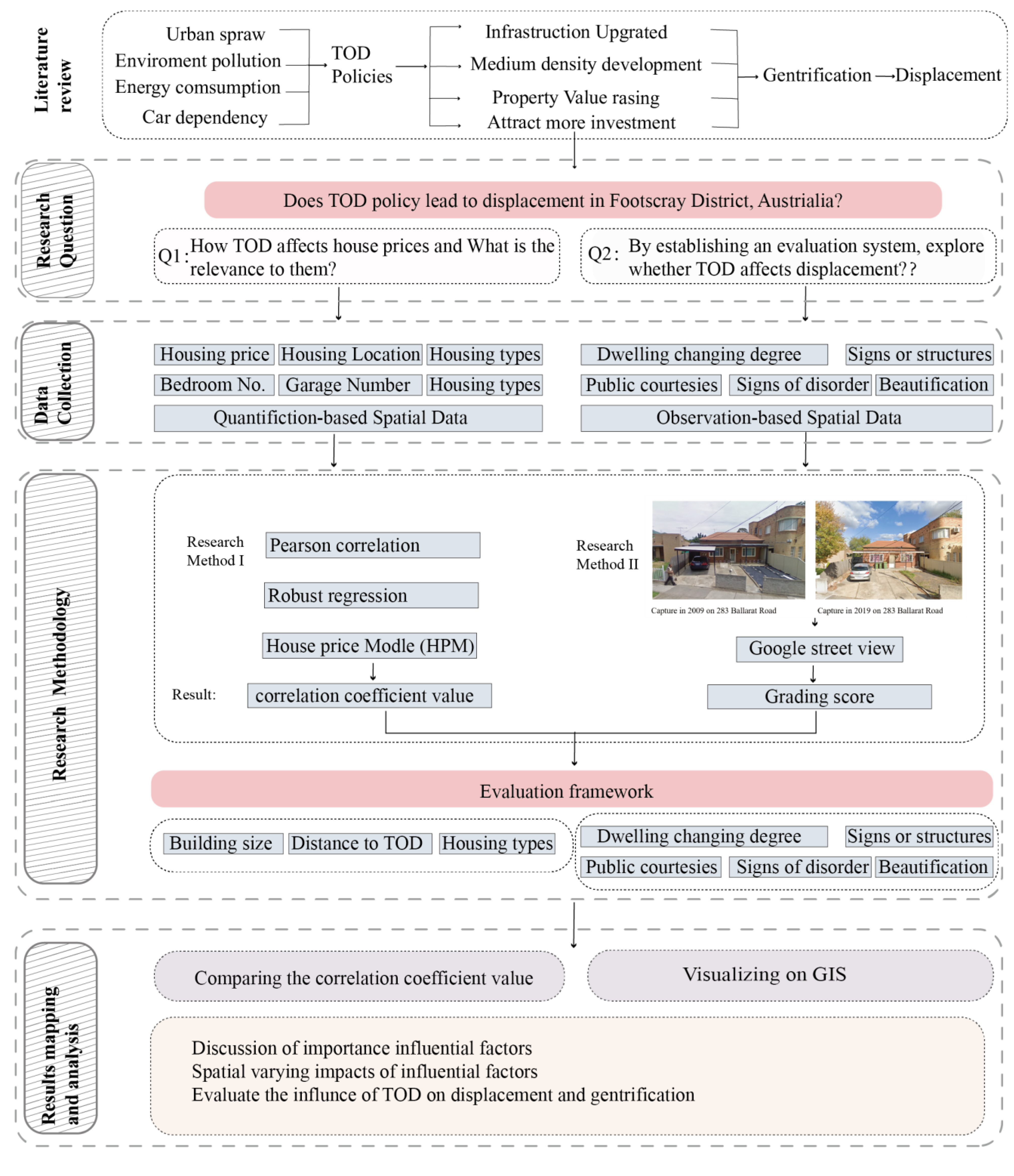
2.3. Gentrification and Displacement in Melbourne

There are various reasons for the current displacements in Melbourne, but they are all directly or indirectly related to the policy. Displacement is the result of gentrification, and it is also the result of policies that do not fully consider the unconscious negative effects of the crowd [33].
For instance, uncontrolled taxation and lending policies have promoted investors’ enthusiasm for housing and created an ‘irrational exuberance’ in the real-estate market [33]. When studying displacement in western Melbourne, it was found that the housing crisis is a major cause of displacement, especially for people with low incomes. Meanwhile, the distribution of social infrastructure can also lead to forced displacement. For example, there is a shortage of schools in the centre of Melbourne, which cannot meet the needs of the family, so they moved to the outer suburb [39].
However, Nethercote [39] also states that the reason for strengthening the construction of infrastructure is to unconsciously invest in the collective consumption budget in capital and upgrade the land by depriving the city of space and building infrastructure as a commodity value. Footscray also has this debate about displacement caused by the Transport City policy, which is a policy that includes infrastructure- and housing-construction incentives [40].

2.4. Research Goals

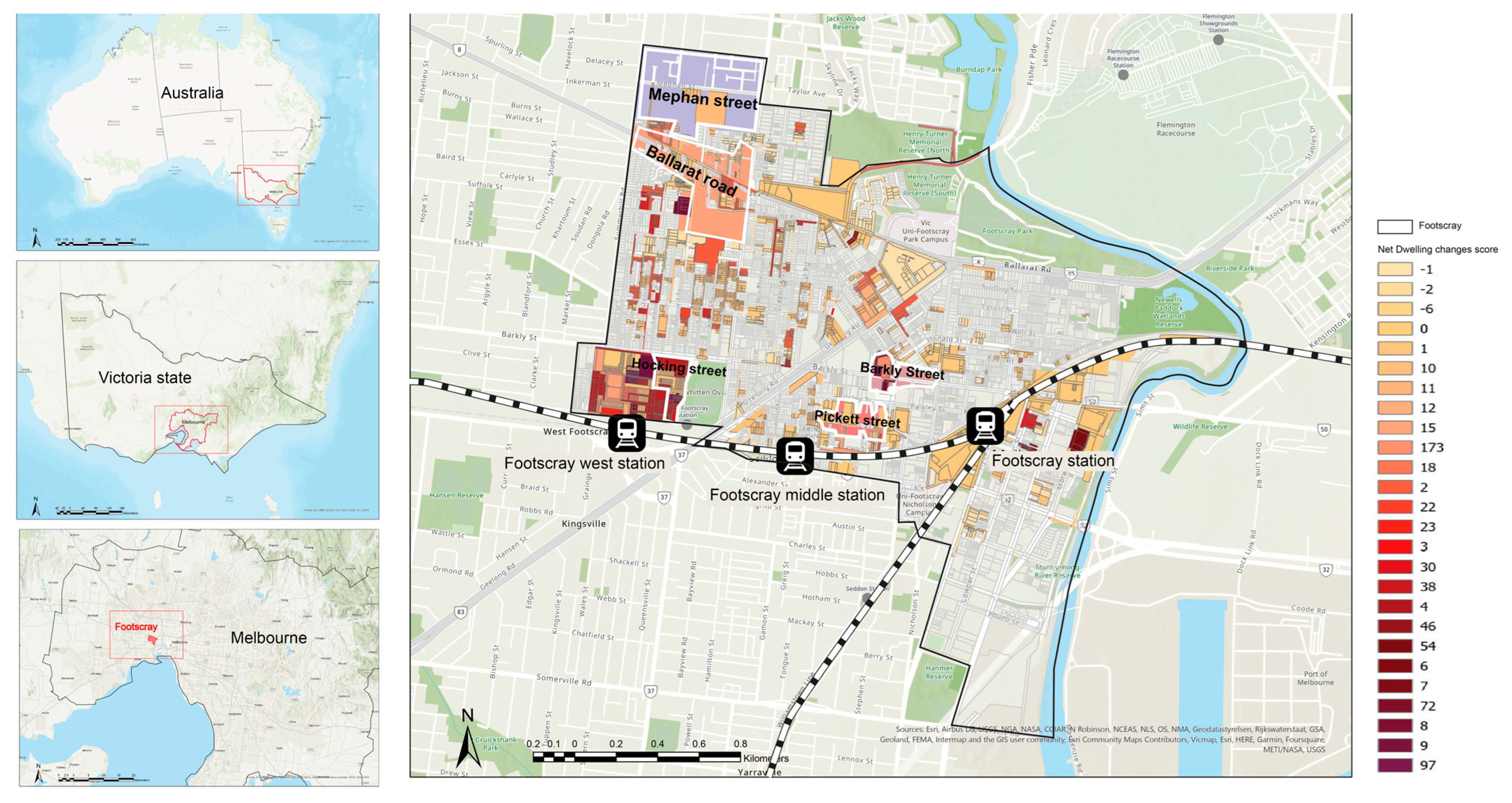
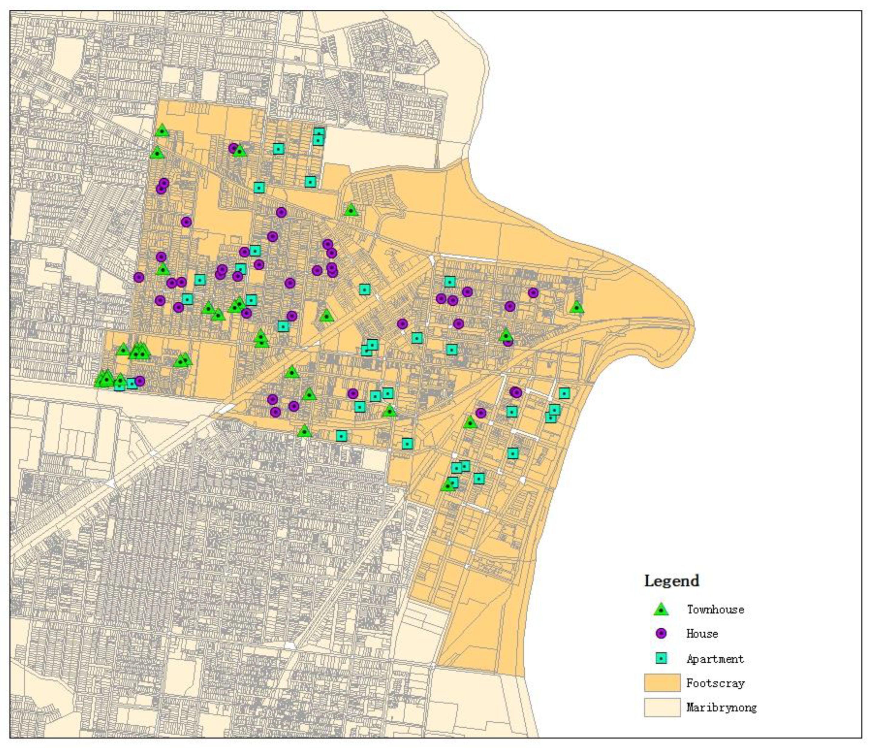
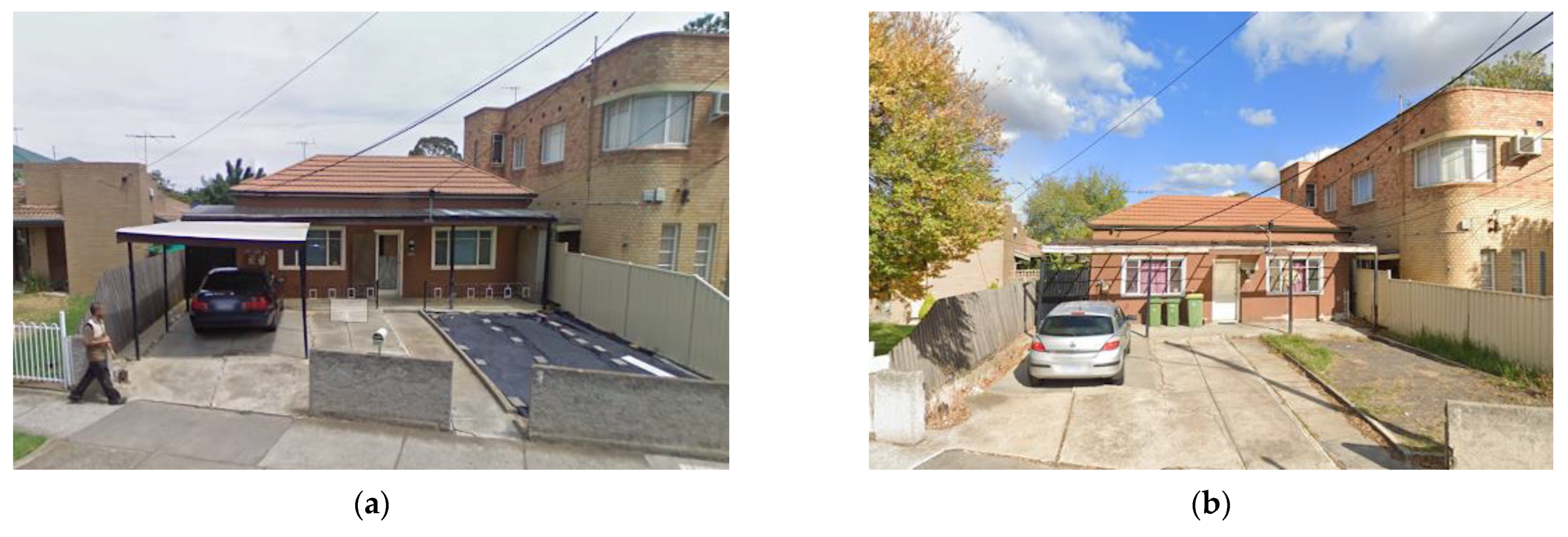
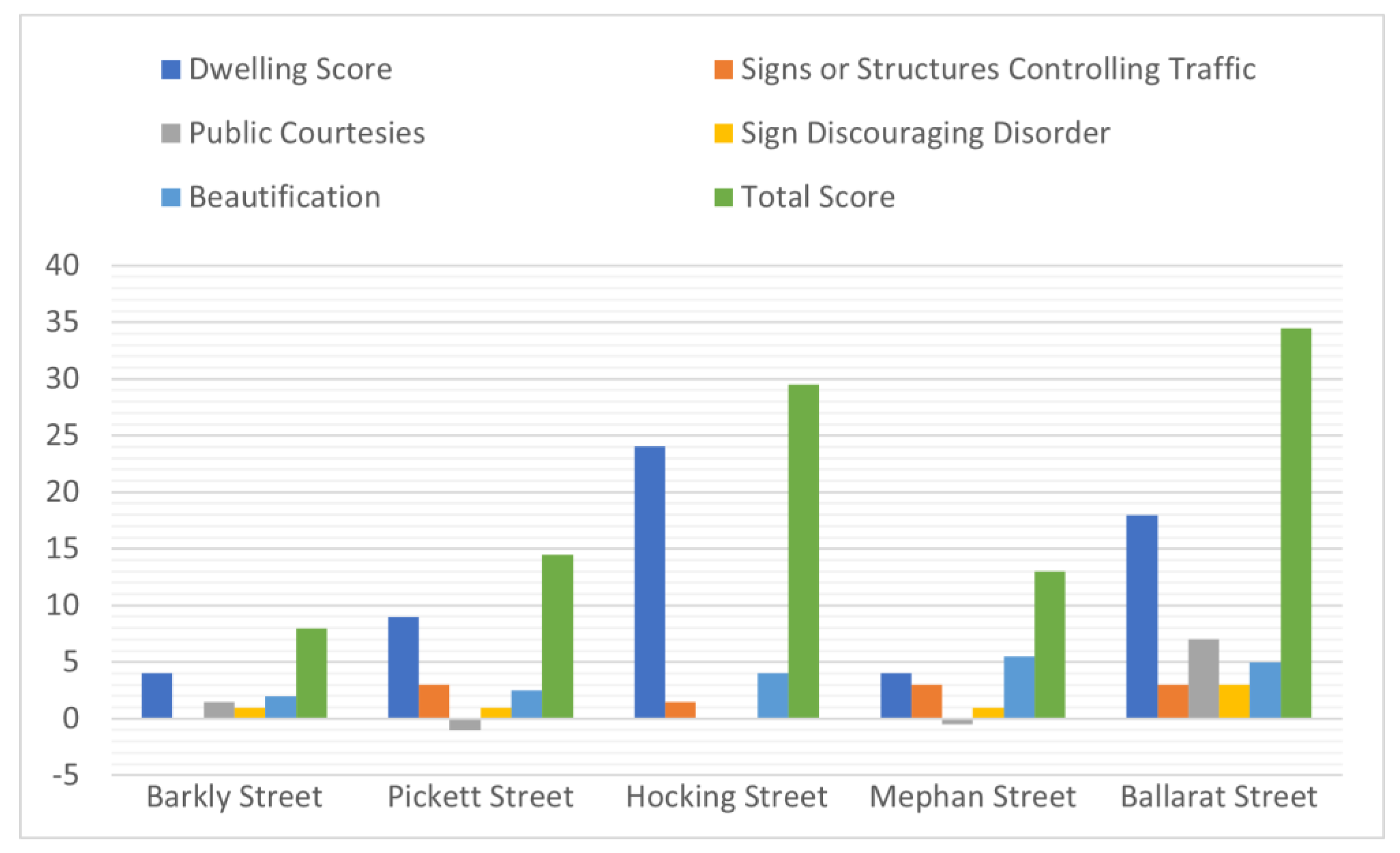
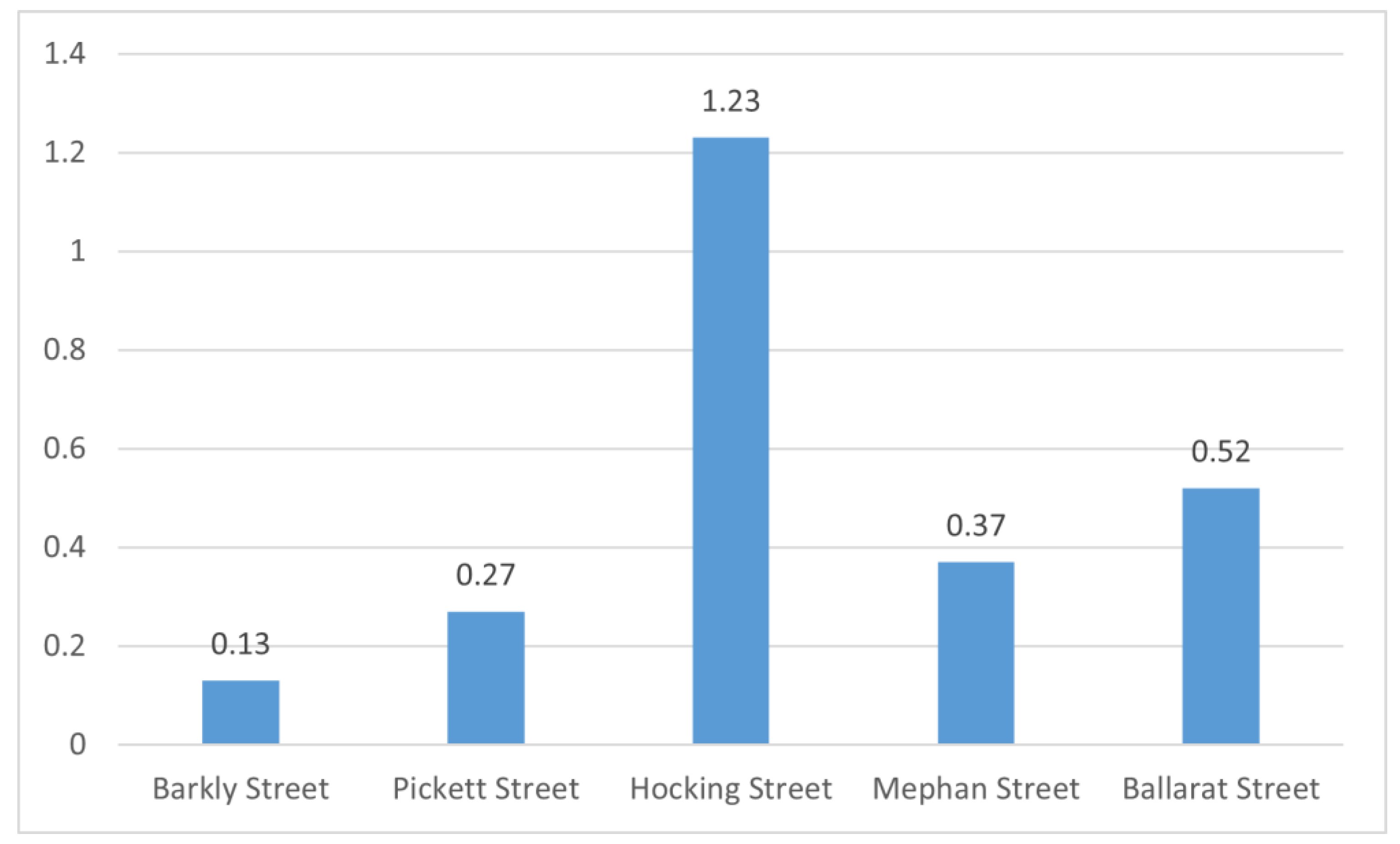
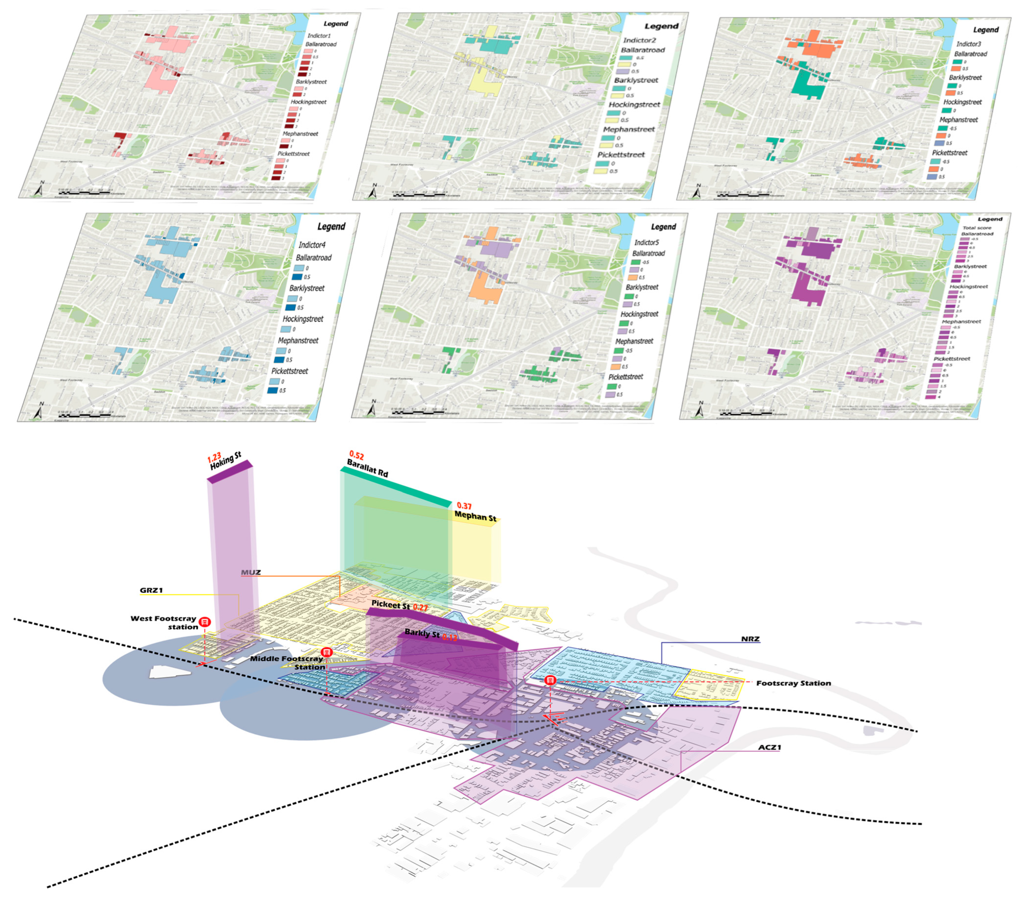
The increasing focus on transit-oriented development (TOD) in Melbourne, driven by rapid population growth, emphasizes the need for compact, high-density mixed land use centred around public transportation. This approach, while offering numerous benefits, also presents challenges, particularly in its impact on resident displacement and addressing issues of poverty and inequality in urban planning. The study conducted in Footscray, Melbourne, employs spatial analysis based on a hedonic price model and Ordinary Least Squares to investigate how TOD influences housing prices and what factors contribute to this effect. The use of observational spatial analysis, including Google Street View (GSV), to select indices like housing development types, traffic signs, sanitation facilities, and house beautification, aids in exploring the extent of redevelopment in TOD streets. This system (Figure 1) is then used to construct an evaluation system, combine the two perspectives together, and assess TOD’s impact on gentrification and displacement from spatial and temporal perspectives [41,42].
The main research objectives include evaluating TOD’s impact on urban sustainability and equity, focusing on changes in housing and the rebuilt environment around public-transport stations. Also, another goal is to build an assessment framework for the TOD policy practice in order to know the extent gentrification in the specific area and be considerate of the minority. Despite the success of TOD internationally, its adoption in Australia, particularly in understudied areas like Footscray, is limited.
Since the concept of gentrification was clarified, there has been a great deal of extensive research into the phenomenon in the context of the United States. There is considerable evidence that gentrification has been experienced across the globe, except for in the United States [43].
The research gap identified is the need for a comprehensive understanding of TOD’s benefits and drawbacks, including how it affects property values and people in daily life [41]. Australia is no exception, but the extent to which gentrification has occurred may not be as dramatic as in the United States [44]. Different country contexts are analysed differently, and thus gentrification in Australia needs to be studied as well. And, based on the existing research in the LR section, we make the following hypothesis: the development of urban TOD construction, although it is a positive government policy and development model, can also due to bring unconscious negative impacts.
However, the causes of gentrification are too complex to include displacement as one of the corollaries of gentrification [27,45]. Also, as Chapple [46] pointed out, while gentrification may be related to investment in transit-oriented development, little of the specific research has quantified their relationship. Therefore, this research will examine displacement as a quantifiable factor to identify appropriate methods and indicators to show how TOD affects displacement [46].
Much of the existing research on displacement has been conducted through quantitative methods to demonstrate that the quantified indicator has an impact on displacement, or to demonstrate the existence of displacement through the aspects represented by the indicator [47]. Others have used a qualitative approach to critique policy shortcomings that have an impact on displacement [48]. However, due to regional social variability, different regions have different social problems and causes of displacement. Most research has been conducted in countries such as the United States and the United Kingdom, with less research conducted in Australia. There is also a lack of literature on the quantitative relationship between policies on infrastructure other than housing policy and dispossession.
The significance of this research lies in adapting existing knowledge and developing novel tools to assess the fairness in the implementation of TOD plans. This assessment aims to guide decisions in TOD planning, reducing potential adverse impacts, and providing insights into balancing economic development and social equity in urban planning.

3. Materials and Methods

3.1. Study Area

Footscray is a vibrant inner-city suburb in Melbourne, Victoria, Australia (Figure 2). Located 5 km west of Melbourne’s central business district is the city of Maribyrnong’s Local Government Area and its council seat, rendering it a crucial part of the city’s urban fabric. Geographically, Footscray’s coordinates are approximately 37°47′–37°48′ S latitude and 144°53′–144°54′ E longitude. The Maribyrnong River significantly shapes the southern boundary, contributing to the distinctive character of the suburb. The site comprises residential, commercial, industrial, and mixed-use areas and is characterized by a very diverse and multicultural central shopping district. It is strategically positioned, acting as a bridge between the inner and outer suburbs of Melbourne. According to the local mayor, the area ‘would soon have the second-highest skyline outside the Melbourne CBD’ [49].
Demographically, Footscray has experienced successive waves of immigration, re-fleeting the cultural diversity Melbourne prides itself on. Over the years, the area has undergone a demographic shift, with a significant mix of long-time residents and newcomers adding to the suburb’s socio-economic vibrancy. It covers an area of about 5 square kilometres and has a population of 17,131 as of 2021 [50]. Due to urban-development plans and the growing demand for housing and commercial space, the suburb has undergone a transformation. These changes affect the availability and allocation of resources and affect the socio-economic conditions of communities. In addition, Footscray’s transport infrastructure plays a key role in its connectivity. It is well served by public transport, including trains, buses, and trams, facilitating activities in the suburbs and connecting it to the wider Melbourne metropolitan area [51]. Accessibility is further improved by the presence of major roads and highways. The significance of this study lies in the unique characteristics of Footscray. As a historical industrial centre, the suburbs have witnessed urban renewal and gentrification, leading to a shift in land-use patterns [52]. In addition, since large infrastructure is more evenly distributed across the region, the impact of market externalities on house prices from other pre-existing infrastructure can be avoided to ensure more accurate experimental results.
In 2001, the Victorian Government launched the Transport Cities and Places Management Plan. Based on TOD’s development principles, the proposal aims to redevelop and cluster higher density mixed-use developments around the 13 designated transport hubs, revitalizing the development through better connectivity of transport and land use. Footscray Railway Station is one of the 13 public-transport hubs.
The Footscray Transit City project falls within a broader strategic planning context. Located close to the CBD and west of Melbourne, Footscray is also at the junction of three rail lines, served by one tram line and 13 bus lines with an extensive public transport infrastructure. Its unique location has made Footscray one of the 25 major activity centres in Melbourne 2030 [21] and a unique position-holder in a major transit network. In addition, the status of the Melbourne @ 5 Million strategy has been upgraded to “Central Activities District” (CAD). Footscray has a key strategic position, and the Footscray Station precinct has multiple targets based on previous strategic work. Some of them are the following: to enhance the environment, to celebrate identity, to develop an intermodal transportation hub, to encourage economic growth, to reinforce connectivity, to increase safety, consolidating retail space, etc. These goals contributed to Footscray becoming a TOD open project.
The Transport-Oriented Development (TOD) strategy implemented in Footscray aims to leverage its strategic location and transport infrastructure to promote sustainable and integrated urban living. As Footscray undergoes urban transformation, it is critical to assess the potential impact of TOD on the community’s internal displacement. This study aims to analyse the interplay between TOD initiatives, socio-economic factors, and displacement dynamics to provide valuable insights into Melbourne’s urban planning and development strategies.

3.2. Date Sources

In order to analyse whether Footscray’s TOD construction has an impact on displacement from temporal and spatial perspectives, in this study, a mixed-methods approach was used to collect and analyse the data. The data sources are displayed on Table 1. Firstly, in the time dimension, the housing spatial data and price data before and after the transit-oriented development in Footscray will be collected. These data will then be analysed using the hedonic price model and Ordinary Least Squares to determine whether distance from the TOD becomes one of the key characteristics that affect the price of different types of housing by comparing data from two periods, before and after the construction of the TOD, and how this happens. Secondly, in the spatial dimension, the Google Street View-based spatial analysis will be used to determine the difference in the amount of housing redevelopment and infrastructure development within and outside of the walkable distance of the TOD. Finally, based on these two analyses, it is inferred whether the construction of TOD is related to residential displacement in Footscray and how these residential displacement indicators are influenced by TOD construction.

3.3. Methodology

The purpose of this study is to analyse whether TOD construction affects residential migration in Footscray, and if so, how it affects residential-migration indicators. As pointed out in the literature review, changes in housing prices, the number of houses rebuilt, and investments in infrastructure development can be used as three indicators to determine whether an area is experiencing residential displacement [53]. Therefore, in the temporal dimension, the changes in different types of houses’ prices before and after the completion of TOD are compared, and in the spatial dimension, the differences in indicators such as the number of housing redevelopments and infrastructure investments within and outside of walking distance from the TOD are compared, and through these comparisons, it is possible to observe whether the construction of a TOD has an impact on these displacement indicators.

3.3.1. Spatial Analysis Based on Hedonic Price Model

In the time dimension, to evaluate the impact of TOD construction on housing prices, a spatial analysis based on the hedonic price model would be a suitable model for housing’s spatial data and price data analysis. The hedonic price model (which is also called the HPM) is a mathematical model, which has been applied by a range of scholars, that can express the relationship between the land parcel’s attributes and its market value [54]. It is particularly suitable for analysing the relationship between the house price and distance in the economic aspect. One of the cases is Sim. et al. [55], who has used the hedonic price model as an analysis method to measure the impact of Box Hill’s TOD on residential property prices. Analogously, Chen et al. [56] have also used the HPM to analyse the impact of Sydney Northwest Metro development on neighbourhood residential property valuations [56].
The HPM is a mathematical model that expresses the relationship between a land parcel’s attributes and its market value [54]. First, it includes collecting the property data as well as price data and spatial data of houses. These data are then substituted into hedonic price models. There are three main forms of the hedonic price model. This research will use the Linear model of the HPM as the analysis model. The equation is shown below. In Equation (1), P represents the housing price, a 0 is the constant, ε is the error term, Z i   represents the housing attribute variable, and a i represents the coefficients that need to be estimated.
P = a 0 + a i Z i + ε   i = 1,2 , 3 , , n
In house-price research, the data are often affected by outliers, leverage points, or heteroscedasticity, which can negatively affect the accuracy and reliability of HPM estimates. To address these issues, robust regression analysis is introduced in this study as a complementary method aimed at improving the robustness of the estimated results and ensuring good resistance to outliers or atypical observations. Robust regression requires the use of iterative methods to solve model parameters, such as iteratively weighted least squares. LeSage and Pace [57] discussed in detail the application of spatial econometric models in their work, including how to deal with outliers and leverage points in spatial data, and also provided in-depth guidance for the application of robustness and spatial regression analysis in the study of real-estate economics.
Finally, in order to verify the results of the previous analysis and further explore the correlation between variables, we used Person correlation analysis. Pearson correlation analysis measures the strength and direction of the linear relationship between two continuous variables [58]. The Pearson correlation analysis is expressed by Equation (2), where r is the correlation coefficient, X is the seven independent variables, i is the sample data, and Y is the dependent variable, the house price before 2012 and the house price after 12 years:
r = i = 1 n X i X ¯ Y i Y ¯ i = 1 n X i X ¯ 2 i = 1 n Y i Y ¯ 2
They ensure the logic and systematisms of the whole research and make the research results more comprehensive and reliable.
This research collected spatial data and housing-attribute data for three types of housing in two time periods, before (2004–2011) and after (2013–2020) TOD construction. For each type of house, 40 house property data points and spatial data points will be collected as a sample. The locations are shown in Figure 3. After collecting data, the HPM will be used as a mathematical model to analyse the relationship between housing attributes (e.g., the distance of the house from the TOD and the size of the house) and market value. To analyse whether there is a relationship between TOD construction and different types of housing prices and how TOD affects the prices of different types of housing in Footscray, housing attributes for both time periods will be used as variables and then regression coefficients and p-values (importance parameters) for these attributes will be calculated using the hedonic price model and robust regression analysis.

3.3.2. Observation-Based Spatial Analysis Using Google Street View (GSV)

In the spatial dimension, observation-based (Google Street View or field observations) spatial analysis would be an appropriate method to analyse the amount of housing redevelopment and infrastructure investment in the Footscray area. A considerable number of scholars have used the method of Google Street View to investigate the gentrification level around the world. For instance, Hwang and Sampson addressed the gap between uneven evolution across times and spaces of gentrification by introducing a method of systematic social observation using Google Street View to detect visible cues of neighbourhood change [59] and combining this with integrating census data, police records, prior street-level observations, community surveys, proximity to amenities, and city budget data on capital investments for the case study of Chicago between 1995 and 2009. Afterwards, Ilic et al. [60] applied Google Street View, which detects gentrification-like visual changes to illustrate where the spatial concentration of visual property improvements was highest within the study area at different times from 2007 to 2016 in Ottawa, Canada [60]. Similarly, Sanchez virtually visited Talca and Santiago [61], Chile, using Google Street View and followed this with an in situ observation to identify and investigate the effects of green gentrification in the Global South. It can be shown that Google Street View used for investigating gentrification is a convincing and credible method.
The spatial analysis is one of the suitable research methods to analyse how transit-oriented development influences house prices in Footscray. Spatial analysis is a geographical analysis that seeks to interpret the patterns of human behaviour and their spatial expression in terms of mathematics and geometry [62]. Spatial analysis is widely used based on microeconomics to predict the spatial patterns that should occur, for example, the growth of networks and urban systems [63]. Also, as Joe pointed out in the third-week lecture, it is possible to show how things exist or change across space by analysing spatial data [64]. The change in street infrastructure, the increase in housing and the difference in built forms are the external manifestations of urban development.
This method in our research combines street-view observations with data analysis to present an accurate and convincing discovery of gentrification. We started with looking at the Housing Development dataset in Geographic Information System (GIS) that was provided by the state of Victoria’s Department of Environment, Land, Water, and Planning [65], and created Figure 2 according to the data. Figure 1 is based on the indicator of total net dwelling, which reveals the net change in dwelling stock over the year, to see how the varying degrees of dwelling changes in number on the map between 2005 and 2016. Then, we discovered there are specific streets that change the most. In order to investigate the gentrification degree of this area before and after the construction of TOD, we selected five specific streets to conduct the street-view observation. We chose three streets within the 400 m range deeply affected by TOD and two streets outside the 800 m range that would not be strongly affected by TOD, which are all the most greatly changed streets within this range shown on the map (Figure 2). We intended for Australians to select the five streets with the greatest changes, so that the comparison could be made to discuss this further at the same level, such as whether the street view near TOD changes greatly and updates more, while the area further away from TOD changes less, or whether there are different discoveries in different streets.
The detailed operation of this method was as follows: after the site selection, a quantitative coding model that helped to code each dwelling according to corresponding GSV and the Housing Development data [66] had been built. This model used a transformed model from Hwang and Sampson, which can be more appropriate in an Australian context [59]. The brief structure of this model is below:
  • Analysing the Housing Development data
    • For assessing the changing degree of dwellings, use the following variables: According to the dataset, if the dwelling on the selected street with the indicator “total net dwellings” is higher than 3, mark the lot as ‘2’; if it is between 1 and 3, mark it as ‘1’; if it is 0, mark it as ‘0’, and mark it as ‘−1’ when the total net dwelling is less than 0. For indicator “area”, if the area increases, mark it as ‘1’, or otherwise ‘0’;
  • Grading and Recording from the Street View
    2.
    Signs or structures controlling traffic (e.g., speed, pedestrian crossing, bike lanes, or parking): we coded 0 for not having the traffic signs and structures and 0.5 for having them;
    3.
    Public courtesies (e.g., bus stop or subway entrance, street furniture, bike racks, public trash cans, or streetlamps): we coded 0 for not having the public courtesies and 0.5 for having them;
    4.
    Signs discouraging disorder (e.g., neighbourhood watch, anti-littering/loitering/drug use/vandalism/graffiti [including if painted over or covered by murals]): we coded 0 for not having the signs and 0.5 for having them;
    5.
    Beautification in personal and vacant areas and public street frontage: we coded 0 for not having any beautification, and 0.5 for having it.
Next, we looked at the dwellings in the year in which we could find the oldest and the latest in the GSV website and captured them for further access, e.g. Figure 4. The reason we chose these years is that we wanted to make sure that every change that may have been impacted by the construction of TOD was stable given these long periods. The TOD was completed in 2012, almost in the middle of the year that we chose (ranging between 2007 and 2021).
This study utilizes the Delphi method in scoring to explore the impact of TOD on housing. Through multiple rounds of expert panel discussions, we have sought to bring together the judgment of professionals to objectively reveal the key factors through which TOD may impact on housing. In modern times, the Delphi method has evolved into a statistical method that not only collates individual opinions, but also aggregates them into a statistically generated consensus through collective intelligence [67]. Hwang et al. also studied gentrification in Chicago neighbourhoods using Google Street View gentrification observation (GGO) as a means of data collection [59]. In this method, they used two raters to score and then they used the average from each indicator. We integrated housing data and scoring criteria (Table 2) and obtained housing scores through multiple rounds of Delphi, which strives to eliminate bias and subjective gaps in scoring.
Finally, after all the collection procedures, we have concluded and labelled all dwellings in terms of the score that we acquired from the quantitative model. We set a n for the new building and b n for housing data from before. First, Formula (3) is used to show how a house indicator is calculated, and then the change score for each house needs to be calculated (Formula (4)). Then, the total value of the five elements and the change score for each of the five streets is calculated (Formulas (5) and (6)). Finally, divide the total street score by the number of homes on that street to the average (Formula (7)). After various data from different streets are obtained, they are compared to find the degree of change for the TOD. we added them up according to the total score of each street and then divided them by the number of dwellings on this street to obtain an average score, as well as each indicator in different streets, to make a comparison.
I i = a n b n i = 2,3 , 4,5 n = d w e l l i n g   N O .
S d = I 1 + I 2 + + I 5
S S = S d n ( n = d w e l l i n g   N O . )
S I i = I i n n = d w e l l i n g   N O .
μ = S s N s ( N s = S a m p l e   n u m b e r   o f   d w e l l i n g   o n   a   s t r e e t )

4. Results

4.1. Findings from the Spatial Analysis Based on the Hedonic Price Model

House attributes including lot size, build size, number of bedrooms, number of bathrooms, number of parking spaces, distance from CBD, and distance from Footscray TOD, were selected as independent variables to calculate their impact on the different type of house prices (descriptive statistics of the property data are shown in Table 3, Table 4 and Table 5).

4.1.1. Different Categories of the Relationship

  • Impact of Housing Configuration
Firstly, data provided in Table 6 shows the correlation between housing configurations (such as the number of bedrooms, bathrooms, and garages) and house prices. By analysing the p-values for correlation using both the HPM and robust methods, we find that the number of bedrooms has a significant impact on house prices, followed by the number of bathrooms, while the impact of the number of garages is relatively smaller. This indicates that internal housing configurations are important considerations in valuations, especially the number of bedrooms and bathrooms, which may reflect the market’s high demand for living comfort.
  • Impact of Housing Distance
In Table 7, we focus on housing-distance features, such as the distance to the CBD (Central Business District) and the distance to the TOD. The data shows that the correlation p-values for the distance to the CBD and TOD undergo significant changes before and after the construction of the TOD. Notably, properties closer to the TOD increase in value correlation significantly after the TOD is built, suggesting the potential role of TOD in enhancing the value of nearby properties. This finding emphasizes the positive impact of public transportation convenience on property values, especially in areas surrounding TOD.
Additionally, based on the data from all three tables, it is observed that the p-values for apartments and townhouses, after the construction of a TOD (after 2012), show significant characteristics with p-values less than 0.01. From the perspective of housing types, apartments demonstrate a greater correlation with the construction of TODs and proximity to the TOD centre. This also suggests that apartments tend to appreciate more in value and witness faster price growth with the increase in TOD infrastructure and the decrease in distance to available services.
The correlation between distance and CBD did not change much across models, while the correlation between distance and TOD was negative in Pearson’s model (e.g., −0.29), which may indicate that properties closer to TODs have higher values, reflecting the positive impact of public-transport accessibility on property values.
  • Impact of Construction Scale
Lastly, Table 8 explores the correlation between the size of the construction (including land size and building size) and house prices. The results indicate that both land and building sizes have their correlation with house prices strengthened after the construction of TODs. This may reflect that larger spaces can provide more possibilities for use and comfort, thereby increasing the market value of the property. Especially after the construction of TOD, these areas might become more popular, further amplifying the positive impact of size on value.

4.1.2. GSV Score of Each Street

The above Figure 2 and tables show the overall and average scores that we obtained from the data collection and analysis. Figure 5 explicitly shows the values of the five indicators corresponding to each street. Figure 6 is obtained by dividing the total score of each street by the number of dwellings in that street to obtain the average score of each street that would be compared with the change equitably happening in each street. According to Figure 5, we can find that although Ballarat Road has the highest overall score, in Figure 6, its average score is lower than Hocking Street. It reveals that Ballarat Road has a higher quantity of updated dwellings or improved environment, while Hocking Street has a higher quality of the improved environment or greater transformation efforts for dwellings. In terms of the characteristics of each street, the findings are as below:
Barkly Street: It has the lowest overall and average scores, with the lowest five indicators among the five streets. The main dwelling type on this street is commercial, and only two buildings have been rebuilt during the year we investigated.
Pickett Street: It is mainly a residential area with three redevelopment dwellings, two lots rebuilt from one-storey dwellings to apartments, and the others from single dwellings to townhouses. The upgraded buildings are accompanied by beautifications, and other environmental improvements have also taken place to some extent.
Hocking Street: With the top beautification and dwelling scores, Hocking Street has the second-highest overall score and the highest average score. The main type of dwelling on this street is residential. Due to nine built townhouses on vacant lots and one rebuilt townhouse, the net dwelling number increases dramatically, as well as the increasing beautification score—in which the land used to be vacant.
Mephan Street: The street has three new developments, with one developed on the vacant lot and two redevelopment dwellings. The amenity environment goes along with the new development.
Ballarat Road: the redevelopment combined rebuilt and newly built dwellings on vacant lots, but the significantly developed building is a four-story apartment building near the intersection of the arterial road: Ballarat Street and Gordon Street.

5. Discussion

5.1. The Effect of TOD on House Price

The finding of the hedonic price model shows that the construction of TOD has an impact on the prices of different types of housing and may unconsciously influence the surrounding affordable house price (residential displacement indicators). In most of the current academic studies, it is stated that the closer the house is to the TOD, the higher the economic value will be. As pointed out by Yuer Chen. et al.’s [56] and Sim. et al.’s [55] studies, the distance from the TOD is negatively correlated with the price of the house. In the finding of the hedonic price model of this study, a similar conclusion was obtained that distance from the TOD is one of the important factors affecting the prices of apartments and houses in Footscray after the completion of the TOD. Distance from a TOD is also negatively related to different types of house prices in Footscray.
However, by comparing the results of the hedonic price model for the three types of houses, it was found that apartments are the housing type most likely to be affected by TOD construction. More importantly, the apartment is one of the affordable types of housing.
Although the authors [66,68] set different policies to support medium-density development and apartment development, the prices of apartments close to the TOD are still much higher than the prices of apartments away from the TOD currently. According to Alfred Marshal [69], the principle of the supply and demand theory of Economics, the higher prices of apartments close to the TOD may be due to the low supply of apartments close to the TOD or the higher demand for apartments near the TOD. However, in general, the distance to the TOD does become an attribute that affects apartment prices. This attribute, in concert with the improvement of public services around apartments, the rise in the number of people settling in Footscray, and other factors, indirectly leads to a decrease in the affordability level of apartments near the TOD and an increase in rents, thus affecting displacement indicators [53] and potentially leading to residential displacement.
TOD does have the potential to be one of the factors driving the redevelopment of the surrounding houses and the improvement of the surrounding infrastructure. Combining the findings of the two approaches representing two different dimensions(Figure 7), they both demonstrate that TOD has the potential to drive the redevelopment of surrounding housing. As the finding of the spatial analysis based on the hedonic price model shows that the closer the house is to the TOD, the higher the price, at the economic level, it would be more profitable to redevelop the low-density houses that are close to the TOD into high-density ones. Furthermore, the findings of the observation-based spatial analysis indicate that a significant amount of townhouse redevelopment is located on Hocking Street, one of the streets close to the TOD. However, the type of housing that the developer chose to redevelop in Hocking Street is not apartments but townhouses, which indicates that it is possible that the developer’s redevelopment near the TOD is aimed at the middle- and high-income groups. However, this also elaborates on the potential for generating residential displacement. Due to the high economic returns of redevelopment around TOD, developers do not redevelop affordable housing types, choosing instead to build townhouses for middle- and high-income groups, in which case there is a significant risk of residential displacement despite the increased housing density around the TOD.

5.2. The Effect of TOD on Displacement

During the street-view research, we wanted to use the indicators related to displacement for judging whether displacement would happen in the circle of the TOD’s effective services. In former research, generally, the infrastructure and environment improvement should have occurred in the inner circle due to the TOD bringing benefits for these areas [71].
It can be easily seen that the highest average score is in Hocking Street, and the second one is in Ballarat Street. These indicators do not reflect that of the general or regular areas. As the indicator relevant to the displacement phenomenon, we still need the price data to combine this with, in order to check that these increasing indicators are able to represent displacement within the TOD range. Choosing 36–40 Hocking Street as an example, the housing price increased and there was an obvious redevelopment and submission in 2004, but meanwhile, a redeveloped site with increasing indicators also can be found at Ballarat Road, which is far away from the TOD station. Thus, from our findings, these increasing indicators could present and describe the displacement to some extent and describe the displacement level but cannot highlight the clear relationship between TOD and displacement from spatial distribution.
Comparing the main indicators of improvement of the environment, then, we found that the group which is outside of the TOD service circle receives a higher average score than the inside of the TOD in beautification, public courtesies, and signs.
Moreover, we found more details using Google Maps; the indicator of total net dwellings shows higher scores in the large site in almost all streets, which mainly contain four types of development: commercial development, housing, public services, and apartments. Following [68] and the transit city plan, the TOD policy started to be operated, encouraging medium-density development close to transport stations. However, it can be seen from data that most developments of apartments are on Ballarat Road rather than the streets within the TOD-radiation distance. Although this reflects the low income of consumers who have immigrated from near the TOD to far away from TOD circles due to the supply of the affordable product, implicating the socioeconomic segregation to some extent [72], it still cannot be shown using a simple TOD-theory model.
The complicated factors existing in a real TOD city cannot abstract the TOD station as the single affected factor. Ballarat Road has a higher score, though it is far away from the TOD station and its policy, mainly because of the well-equipped infrastructure. Musterd, Marcińczak, van Ham, and Tammaru [73] state that social welfare and infrastructure can also have an impact on social justice and reflect on spatial distribution. Also, the Hospital and education source in Mephan and Ballarat, and the commercial complexes, can be regarded as a positive exterior, which also increases the land value and pushes the land development [74]. These indicators are influenced by diverse dimension overlays; thus, they are not reflecting the general regularity of the TOD theory.
Although the construction of a TOD has a driving effect on the redevelopment of the surrounding houses, there are many other external factors that will drive the redevelopment of the houses in the area. Combining the findings of the two methods representing two different dimensions, a new phenomenon was found in Footscray. As the finding of the spatial analysis based on the hedonic price model shows, apartment prices are most likely to be influenced by the distance between the apartment and the TOD. However, the finding of the observation-based spatial analysis shows that although Ballarat Street is far from the TOD, there are still a large number of apartment redevelopment projects on this street. In terms of economic benefits, the proximity of Ballarat Streets to the TOD is not a positive motivation for developers to redevelop apartments in Ballarat. However, the Footscray phenomenon demonstrates that, in addition to the external factor of TOD construction, there are many factors that may influence the amount of housing redevelopments (residential-displacement indicators), such as the improvement of public infrastructure around Ballarat Street and the existing well-developed transportation within this area, which are factors that may drive investors to redevelop. So, while TOD is likely to drive the redevelopment of surrounding houses, there are a number of factors that can drive the amount of housing redevelopment in an area in reality. However, in the reality of Footscray, apartment redevelopment is concentrated on in streets far from the TOD, which creates a lack of affordable housing within the TOD area, and may indirectly drive the occurrence of residential displacement in Footscray.

6. Conclusions

The case study of Footscray demonstrates that displacement is a temporal and spatial phenomenon influenced by TOD. The HPM model reveals that house prices increase as TOD distance decreases, with apartments being the most affected. However, our methods cannot separately measure the unconscious negative impact of TOD on displacement. Google Street View analysis shows that displacement factors are complex, making TOD one of the compounded influences. This research supports future housing and transport policies to counteract TOD’s unintended effects and reduce displacement, achieving social justice while promoting high-density residential development near TOD areas, ensuring affordable housing provision, which is crucial for social equity [28].
Additionally, measures should be taken to mitigate land-value appreciation’s adverse effects, especially for vulnerable communities. Our research highlights the importance of urban-development policies that prioritize social equity and inclusivity. TOD offers opportunities for sustainable growth, but addressing its unintended consequences requires nuanced policy interventions. Despite limitations like the subjectivity of manual scoring and the incomplete consideration of factors influencing house prices in the HPM formula, our study provides valuable insights into urban planning and policy debates. Further research is needed to clarify the relationship between TOD and displacement more clearly.

Author Contributions

Conceptualization, X.W. and Y.X.; methodology, B.L., L.X. and J.H.; software, Y.X. and J.H.; validation, X.W., Y.X., L.X. and J.H.; formal analysis, Y.X.; investigation, X.W., Y.X. and L.X.; resources, J.H.; data curation, X.W., Y.X. and L.X.; writing—original draft preparation, X.W., Y.X., L.X. and J.H.; writing—review and editing, X.W., B.L. and Y.X.; visualization, X.W.; supervision, Y.X.; project administration, Y.X. All authors have read and agreed to the published version of the manuscript.

Funding

This research was funded by University of Oklahoma Libraries’ Open Access Fund.

Data Availability Statement

The raw data supporting the conclusions of this article will be made available by the authors on request.

Conflicts of Interest

The authors declare no conflicts of interest.

References

  1. Calthorpe, P. The Next American Metropolis: Ecology, Community, and the American Dream; Princeton Architectural Press: Hudson, NY, USA, 1993. [Google Scholar]
  2. 2013 at ITDP: Exciting Projects and Tools for Success—Institute for Transportation and Development Policy. Available online: https://www.itdp.org/2013/12/31/2013-at-itdp-exciting-projects-and-tools-for-success/ (accessed on 22 February 2024).
  3. Goetz, J.L.; Keltner, D.; Simon-Thomas, E. Compassion: An Evolutionary Analysis and Empirical Review. Psychol. Bull. 2010, 136, 351–374. [Google Scholar] [CrossRef] [PubMed]
  4. Tourism & Transport Forum Australia Tourism & Transport Forum Australia. 2010. Available online: https://www.agriculture.gov.au/sites/default/files/sitecollectiondocuments/ag-food/working-holiday/submissions/tourism-transport-forum.pdf (accessed on 22 February 2024).
  5. Kenworthy, J.R.; Laube, F.B.; Newman, P.; Barter, P.; Raad, T.; Poboon, C.; Guia, B., Jr. An International Sourcebook of Automobile Dependence in Cities 1960–1990; National Academies of Sciences: Washington, DC, USA, 1999; ISBN 978-0-87081-523-2. [Google Scholar]
  6. Planning 20-Minute Neighbourhoods. Available online: https://www.planning.vic.gov.au/guides-and-resources/strategies-and-initiatives/20-minute-neighbourhoods (accessed on 8 May 2023).
  7. Hess, D.B.; Almeida, T.M. Impact of Proximity to Light Rail Rapid Transit on Station-Area Property Values in Buffalo, New York. Urban Stud. 2007, 44, 1041–1068. [Google Scholar] [CrossRef]
  8. Knowles, R.D.; Ferbrache, F. (Eds.) Transit Oriented Development and Sustainable Cities: Economics, Community and Methods; Edward Elgar Publishing: Northampton, MA, USA, 2019. [Google Scholar] [CrossRef]
  9. Salat, S.; Ollivier, G. Transforming the Urban Space through Transit-Oriented Development the 3V Approach. Available online: https://collaboration.worldbank.org/content/usergenerated/asi/cloud/attachments/sites/collaboration-for-development/en/groups/tod-cop/documents/_jcr_content/content/primary/blog/tod_cop_completingi-G9GT/D3-1.1-TOD-TDD-3v-session.pdf (accessed on 8 May 2023).
  10. Griffiths, B.; Curtis, C. Effectiveness of Transit Oriented Development in Reducing Car Use: Case Study of Subiaco, Western Australia. Urban Policy Res. 2017, 35, 391–408. [Google Scholar] [CrossRef]
  11. Thomas, R.; Pojani, D.; Lenferink, S.; Bertolini, L.; Stead, D.; van der Krabben, E. Is transit-oriented development (TOD) an internationally transferable policy concept? Reg. Stud. 2018, 52, 1201–1213. [Google Scholar] [CrossRef]
  12. Smith, O.R. Reconnecting America’s Center For Transit-Oriented Development. Available online: https://reconnectingamerica.org/assets/Uploads/2004Ctodreport.pdf (accessed on 8 May 2023).
  13. Scheurer, J.; Porta, S. Centrality and connectivity in public transport networks and their significance for transport sustainability in cities. In Proceedings of the World Planning Schools Congress, Global Planning Association Education Network, Mexico City, Mexico, 13–16 July 2006. [Google Scholar]
  14. Ali, L.; Nawaz, A.; Iqbal, S.; Basheer, M.A.; Hameed, J.; Albasher, G.; Shah, S.A.R.; Bai, Y. Dynamics of Transit Oriented Development, Role of Greenhouse Gases and Urban Environment: A Study for Management and Policy. Sustainability 2021, 13, 2536. [Google Scholar] [CrossRef]
  15. Goodwill, J.; Hendricks, S.J. Building Transit Oriented Development in Established Communities; Center for Urban Transportation Research: Tampa, FL, USA, 2002. [Google Scholar]
  16. Bloomberg Philanthropies. Available online: https://www.bloomberg.org/ (accessed on 5 January 2024).
  17. Portland Council (Ed.) The Portland Plan. Available online: https://www.portland.gov/bps/planning/about-bps/portland-plan (accessed on 8 May 2023).
  18. City of Cape Town. Transit Oriented Development Strategic Framework (Policy Number 46487). 2016. Available online: http://resource.capetown.gov.za/documentcentre/Documents/City%20strategies,%20plans%20and%20frameworks/Transit%20Oriented%20Development%20(TOD)%20Strategic%20Framework%20Policy.pdf (accessed on 8 May 2023).
  19. Su, S.; Zhang, J.; He, S.; Zhang, H.; Hu, L.; Kang, M. Unraveling the Impact of TOD on Housing Rental Prices and Implications on Spatial Planning: A Comparative Analysis of Five Chinese Megacities. Habitat Int. 2021, 107, 102309. [Google Scholar] [CrossRef]
  20. Ibraeva, A.; Correia, G.H.d.A.; Silva, C.; Antunes, A.P. Transit-oriented development: A review of research achievements and challenges. Transp. Res. Part A Policy Pract. 2020, 132, 110–130. [Google Scholar] [CrossRef]
  21. Department of Infrastructure (Vic). Melbourne 2030: Planning for Sustainable Growth; Government of Victoria: Melbourne, Australia, 2002.
  22. Victorian Government. Linking Melbourne: Metropolitan Transport Plan. 2008. Available online: https://catalogue.nla.gov.au/Record/3414868 (accessed on 8 May 2023).
  23. Newman, P. Transit Oriented Development: An Australian Overview; Curtin University: Bentley, Australia, 2005. [Google Scholar]
  24. Pegler, C.; Li, H.; Pojani, D. Gentrification in Australia’s largest cities: A bird’s-eye view. Aust. Plan. 2020, 56, 191–205. [Google Scholar] [CrossRef]
  25. O’Hanlon, S.; Hamnett, C. Deindustrialisation, Gentrification and the Reinvention of the Inner City: London and Melbourne, c. 1960–2008. Urban Policy Res. 2009, 27, 211–216. [Google Scholar] [CrossRef]
  26. Victoria State Government. Plan Melbourne 2017–2050. Planning. Available online: https://www.planning.vic.gov.au/guides-and-resources/strategies-and-initiatives/plan-melbourne/the-plan (accessed on 5 January 2024).
  27. Wang, Z. Beyond displacement—Exploring the variegated social impacts of urban redevelopment. Urban Geogr. 2020, 41, 703–712. [Google Scholar] [CrossRef]
  28. Smith, D. Social Fluidity and Social Displacement. Sociol. Rev. 2010, 58, 680–698. [Google Scholar] [CrossRef]
  29. Lees, L.; Slater, T.; Wyly, E. Gentrification; Routledge: New York, NY, USA, 2008. [Google Scholar]
  30. Zhang, B.; Song, Y.; Liu, D.; Zeng, Z.; Guo, S.; Yang, Q.; Wen, Y.; Wang, W.; Shen, X. Descriptive and Network Post-Occupancy Evaluation of the Urban Public Space through Social Media: A Case Study of Bryant Park, NY. Land 2023, 12, 1403. [Google Scholar] [CrossRef]
  31. Holwitt, P. Urban Renewal in India: Accommodating People, Ideas and Lifeworlds in Mumbai’s Redeveloping Chawls; Routledge: Abingdon, UK, 2020. [Google Scholar]
  32. Knowles, R.D.; Ferbrache, F. Introduction to Transit Oriented Development and Sustainable Cities: Economics, Community and Methods. In Transit Oriented Development and Sustainable Cities; Edward Elgar Publishing: Cheltenham, UK, 2019; Available online: https://www.elgaronline.com/downloadpdf/edcoll/9781788971706/9781788971706.00007.pdf (accessed on 22 June 2021).
  33. Garton, S.; Lack, J. A History of Footscray. Labor Hist. 1992, 64. Available online: https://www.tandfonline.com/toc/clah20/current (accessed on 5 January 2024). [CrossRef]
  34. Weller, S.; van Hulten, A. Gentrification and Displacement: The Effects of a Housing Crisis on Melbourne’s Low-Income Residents. Urban Policy Res. 2012, 30, 25–42. [Google Scholar] [CrossRef]
  35. Derakhti, L.; Baeten, G. Contradictions of Transit-Oriented Development in Low-Income Neighborhoods: The Case Study of Rosengård in Malmö, Sweden. Urban Sci. 2020, 4, 20. [Google Scholar] [CrossRef]
  36. Rayle, L. Investigating the Connection Between Transit-Oriented Development and Displacement: Four Hypotheses. Hous. Policy Debate 2015, 25, 531–548. [Google Scholar] [CrossRef]
  37. Dong, H. Rail-Transit-Induced Gentrification and the Affordability Paradox of TOD. J. Transp. Geogr. 2017, 63, 1–10. [Google Scholar] [CrossRef]
  38. Sustainability and Displacement: Assessing the Spatial Pattern of Residential Moves Near Rail Transit|National Center for Sustainable Transportation. Available online: https://ncst.ucdavis.edu/project/sustainability-and-displacement-assessing-spatial-pattern-residential-moves-near-rail (accessed on 22 February 2024).
  39. Gentrification and Displacement Pressures around Transit-Oriented Development in Los Angeles|Sustainable LA Grand Challenge. Available online: https://sustainablela.ucla.edu/research-portal/project/gentrification-and-displacement-pressures-around-transit-oriented (accessed on 22 February 2024).
  40. Nethercote, M. When Social Infrastructure Deficits Create Displacement Pressures: Inner City Schools and the Suburbanization of Families in Melbourne. Int. J. Urban Reg. Res. 2017, 41, 443–463. Available online: https://onlinelibrary.wiley.com/doi/full/10.1111/1468-2427.12509 (accessed on 5 January 2024). [CrossRef]
  41. Huston, M.A. Disturbance, productivity, and species diversity: Empiricism vs. logic in ecological theory. Ecology 2014, 95, 2382–2396. Available online: https://esajournals.onlinelibrary.wiley.com/doi/10.1890/13-1397.1 (accessed on 5 January 2024). [CrossRef]
  42. Padeiro, M.; Louro, A.; da Costa, N.M. Transit-oriented development and gentrification: A systematic review. Transp. Rev. 2019, 39, 733–754. [Google Scholar] [CrossRef]
  43. Kim, H.M.; Han, S.S.; O’connor, K.B. Foreign housing investment in Seoul: Origin of investors and location of investment. Cities 2015, 42, 212–223. [Google Scholar] [CrossRef]
  44. Downey, A. Religious affiliation, education and Internet use. arXiv 2014, arXiv:1403.5534. [Google Scholar]
  45. Atkinson, R. Padding the Bunker: Strategies of Middle-class Disaffiliation and Colonisation in the City. Urban Studies 2006, 43, 819–832. [Google Scholar] [CrossRef]
  46. Williams, P. Class constitution through spatial reconstruction? A re-evaluation of gentrification in Australia, Britain, and the United States. In Gentrification of the City; Routledge: Abingdon, UK, 1986. [Google Scholar]
  47. Chapple, K. Mapping Susceptibility to Gentrification: The Early Warning Toolkit; University of California: Berkeley, CA, USA, 2009. [Google Scholar] [CrossRef]
  48. Chapple, K.; Waddell, P.; Chatman, D.; Zuk, M.; Loukaitou-Sideris, A.; Ong, P.; Gorska, K.; Pech, C.; Gonzalez, S.R. Developing a New Methodology for Analyzing Potential Displacement; UC Berkeley: Berkeley, CA, USA, 2017. [Google Scholar]
  49. Debrezion, G.; Pels, E.; Rietveld, P. The Impact of Railway Stations on Residential and Commercial Property Value: A Meta-analysis. J. Real. Estate Finan. Econ. 2007, 35, 161–180. [Google Scholar] [CrossRef]
  50. New Mayor for Maribyrnong Growth—Council—News—Maribyrnong Leader. Available online: https://web.archive.org/web/20120226205950/http://maribyrnong-leader.whereilive.com.au/news/story/master-plan-for-maribyrnong-growth-fbready/ (accessed on 5 January 2024).
  51. Australian Bureau of Statistics (ABS). Footscray 2021 Census All Persons QuickStats. 2021. Available online: https://www.abs.gov.au/census/find-census-data/quickstats/2021/SAL20935 (accessed on 8 May 2023).
  52. Maribyrnong City Council, Maribyrnong Integrated Transport Strategy. 2012. Available online: https://www.maribyrnong.vic.gov.au/Home (accessed on 8 May 2023).
  53. Melbourne Histoury Research Group, History of Footscray. 2021. Available online: https://tomelbourne.com.au/history-footscray/ (accessed on 8 May 2023).
  54. Jamme, H.-T.; Rodriguez, J.; Bahl, D.; Banerjee, T. A Twenty-Five-Year Biography of the TOD Concept: From Design to Policy, Planning, and Implementation. J. Plan. Educ. Res. 2019, 39, 409–428. [Google Scholar] [CrossRef]
  55. Anderson, H. Value of Nature Implicit in Property Prices–Hedonic Pricing Method (HPM) Methodology Note; Office for National Statistics: London, UK, 2018.
  56. Sim, E.; Krause, A.; Winson-Geideman, K. The Impact of Transit Oriented Development (TOD) on Residential Property Prices: The Case of Box Hill, Melbourne. Pac. Rim Prop. Res. J. 2016, 21, 199–214. [Google Scholar] [CrossRef]
  57. Chen, Y.; Yazdani, M.; Mojtahedi, M.; Newton, S. The impact on neighbourhood residential property valuations of a newly proposed public transport project: The Sydney Northwest Metro case study. Transp. Res. Interdiscip. Perspect. 2019, 3, 100070. [Google Scholar] [CrossRef]
  58. LeSage, J.; Pace, R.K. Introduction to Spatial Econometrics, 1st ed.; Chapman and Hall/CRC: Boca Raton, FL, USA, 2009. [Google Scholar] [CrossRef]
  59. Field, A. Discovering Statistics Using IBM SPSS Statistics, 5th ed.; Sage Edge: Washington, DC, USA, 2017. [Google Scholar]
  60. Hwang, J.; Sampson, R.J. Divergent Pathways of Gentrification: Racial Inequality and the Social Order of Renewal in Chicago Neighborhoods. Am. Sociol. Rev. 2014, 79, 726–751. [Google Scholar] [CrossRef]
  61. Ilic, L.; Sawada, M.; Zarzelli, A. Deep mapping gentrification in a large Canadian city using deep learning and Google Street View. PLoS ONE 2019, 14, e0212814. [Google Scholar] [CrossRef]
  62. Sanchez, M. Using Google Street View to Examine Green Gentrification: A Case Study in Chile. Front. Sustain. Cities 2019, 3, 684231. [Google Scholar]
  63. Mayhew, S. A Dictionary of Geography; OUP Oxford: Oxford, UK, 2015. [Google Scholar]
  64. Abdulla, H.M.; Ibrahim, M.A. The Impact of Urban Spatial Plan on Land Value: An Approach System to Relating Space Syntax Premises to the Land Price. Sustainability 2023, 15, 7239. [Google Scholar] [CrossRef]
  65. Rakoto, P.Y.; Deilami, K.; Hurley, J.; Amati, M.; Sun (Chayn), Q. Revisiting the cooling effects of urban greening: Planning implications of vegetation types and spatial configuration. Urban For. Urban Green. 2021, 64, 127266. [Google Scholar] [CrossRef]
  66. DELWP. Housing Outcomes in Established Melbourne 2005 to 2016; Government of Victoria: Melbourne, Australia, 2018.
  67. Nasa, P.; Jain, R.; Juneja, D. Delphi methodology in healthcare research: How to decide its appropriateness. World J. Methodol. 2021, 11, 116–129. [Google Scholar] [CrossRef] [PubMed]
  68. Spinney, A.; Reynolds, M.A.; Wulff, M.; Atkinson, R. Gentrification and Displacement: The Household Impacts of Neighbourhood Change; AHURI Final Report No. 160; Australian Housing and Urban Research Institute: Melbourne, Australia, 2011. [Google Scholar]
  69. Maribyrnong City Council. Footscray Structure Plan. 2014. Available online: https://hdp-au-prod-app-marib-yourcity-files.s3.ap-southeast-2.amazonaws.com/5516/3651/5558/bdeb8ed439e461135c08b53a3aba229b_Footscray_Structure_Plan-2014.pdf (accessed on 8 May 2023).
  70. Maribyrnong Housing Strategy—Maribyrnong. Available online: https://www.maribyrnong.vic.gov.au/Building-and-Planning/Planning-Services/Current-and-future-planning/Strategies-Plans-and-Policies/Maribyrnong-Housing-Strategy (accessed on 6 January 2024).
  71. Reisman, D. Economics and Principles. In Alfred Marshall’s Mission; Palgrave Macmillan: London, UK, 1990; pp. 60–105. [Google Scholar] [CrossRef]
  72. van Lierop, D.; Maat, K.; El-Geneidy, A. Talking TOD: Learning about transit-oriented development in the United States, Canada, and the Netherlands. J. Urban. 2016, 10, 49–62. [Google Scholar] [CrossRef]
  73. Musterd, S.; Marcińczak, S.; van Ham, M.; Tammaru, T. Socioeconomic segregation in European capital cities. Increasing separation between poor and rich. Urban Geogr. 2017, 38, 1062–1083. [Google Scholar] [CrossRef]
  74. Rossi-Hansberg, E.; Sarte, P.-D. Economics of Housing Externalities. In International Encyclopedia of Housing and Home; Elsevier: Amsterdam, The Netherlands, 2012; pp. 47–50. [Google Scholar] [CrossRef]
Figure 1. The research flow diagram.
Buildings 14 00824 g001
Figure 2. Location of the study area (left panel) and the spatial distribution of the five streets and transit station in Footscray with the net dwelling changing score.
Buildings 14 00824 g002
Figure 3. The locations and building types of samples in Footscray.
Buildings 14 00824 g003
Figure 4. One of the samples collected at Ballarat Road: (a) captured in 2009 on 283 Ballarat Road; (b) capture in 2019 on 283 Ballarat Road.
Buildings 14 00824 g004
Figure 5. Five indicators and total score of each street.
Buildings 14 00824 g005
Figure 6. Average dwelling-change score of each street.
Buildings 14 00824 g006
Figure 7. Separated indicators of each street and the total score of change options for people with low incomes [70], who are more likely to experience residential displacement.
Buildings 14 00824 g007
Table 1. Data sources.
DataSourceReference YearSpatial ResolutionData Availability
Administrative boundary dataData.gov.au2021vector dataFreely available
Transport sites and railway-plan policyVIC plan2021PNGFreely available
Housing rates InformationAurin2021shapefileAvailable with application
Housing locations, Types, and Price Real-estate company2012–2021CSVAvailable by using crawler extraction
Building surroundingsGoogle street view2012–2021JPGFreely available
Table 2. Scoring standard based on coding guide (Hwang and Sampson, 2014) [59].
Observation Instrument ItemSituationMark
Changing degree of housingTotal net dwellings>32
1, 2, 31
0−1
Areaincrease1
decrease0
Signs or structures controlling trafficHave0.5
Do not have0
Public courtesiesHave0.5
Do not have0
Sign discouraging disorderHave0.5
Do not have0
BeautificationHave0.5
Do not have0
Table 3. Dwellings’ change types.
CategoryDescription
No big changes (score less than 0).The exterior of the building and the surroundings remain the same.
Slight changes (score between 0 and 1).The exterior of the building has a slight change on one or two of the following four indicators: signs or structures to do with traffic, public courtesies, signs discouraging disorder, or beautification.
Big changes (score more than 1).The exterior of the building has a change in the following four indicators: signs or structures to do with traffic, public courtesies, signs discouraging disorder, or beautification; or, there are rebuilt buildings.
Table 4. Descriptive statistics of the apartment property data.
Apartment
No.MeanMin.Max.S.D.
No. bed401.8130.54
No. bathroom401.17120.38
No. garage401020.33
DisToCBD40612050007500686.42
DisToTOD405923541500303
Land Size4021776286941983.6
Build size40694414018.37
Apartment Price After 201240469,708100,0001,135,000160,827.5
Apartment Price Before 201240359,706132,000705,000112,741.7
Table 5. Descriptive statistics of the townhouse property data.
Townhouse
No.MeanMin.Max.S.D.
No. bedroom402.7530.67
No. bathroom401.72320.64
No. garage401.4220.55
DisToCBD40699151007600730
DisToTOD40544861250291
Land Size401297327242.2
Build size401455427652.02
Apartment Price After 201240819,175328,0001,411,000180,770
Apartment Price Before 201240472,071241,000627,15099,098
Table 6. Results: impacts of house features on seven factors of properties.
House Features
ModelsHPMRobustPearson
Before 2012ApartmentNo. bedroom0.920.8470.414 **
No. bathroom0.035 *0.040 *0.513 **
No. garage0.3820.3880.148
HousingNo. bedroom0.2510.3120.279
No. bathroom0.1620.1590.416 **
No. garage0.033 *0.0690.503 **
Town housingNo. bedroom0.7010.4890.128
No. bathroom0.2420.2270.29
No. garage0.3570.2460.330 *
After 2012ApartmentNo. bedroom0.140.049 *0.671 **
No. bathroom0.9560.9710.272
No. garage0.8710.4740.169
HousingNo. bedroom0.0640.039 *0.520 **
No. bathroom0.4250.3470.358 *
No. garage0.2470.1550.508 **
Town housingNo. bedroom0.1860.060.560 **
No. bathroom0.3930.490.142
No. garage0.0560.033 *0.510 **
Note: (*) signifies a p-value less than or equal to 0.05, (**) indicates a p-value less than or equal to 0.01.
Table 7. Results: impacts of availability on seven factors of properties.
Availability
ModelsHPMRobustPearson
Before 2012ApartmentDistance To CBD0.9930.957−0.267
Distance To TOD0.2030.13−0.29
HousingDistance To CBD0.6050.764−0.021
Distance To TOD0.7580.676−0.236
Town housingDistance To CBD0.5610.4450.122
Distance To TOD0.014 *0.003 **−0.388 *
After 2012ApartmentDistance To CBD0.7830.679−0.268
Distance To TOD0.002 **0.000 **−0.276
HousingDistance To CBD0.4160.464−0.165
Distance To TOD0.1910.101−0.332 *
Town housingDistance To CBD0.007 **0.000 **−0.155
Distance To TOD0.1030.023 *−0.538 **
Note: (*) signifies a p-value less than or equal to 0.05, (**) indicates a p-value less than or equal to 0.01.
Table 8. Results: impacts of construction scales on seven factors of properties.
Construction Scales
ModelsHPMRobustPearson
Before 2012ApartmentLand Size0.010 **0.007 *0.383 **
Building Size0.000 **0.000 *0.662 **
HousingLand Size0.8250.769−0.085
Building Size0.5330.5970.350 *
Town housingLand Size0.8610.831−0.082
Building Size0.1640.10.159
After 2012ApartmentLand Size0.8660.8450.037
Building Size0.000 ***0.000 **0.838 **
HousingLand Size0.7440.675−0.161
Building Size0.5210.7250.447 **
Town housingLand Size0.008 ***0.000 **−0.276
Building Size0.1150.009 **0.548 **
Note: (*) signifies a p-value less than or equal to 0.05, (**) indicates a p-value less than or equal to 0.01, and (***) signifies a p-value less than or equal to 0.001.
Disclaimer/Publisher’s Note: The statements, opinions and data contained in all publications are solely those of the individual author(s) and contributor(s) and not of MDPI and/or the editor(s). MDPI and/or the editor(s) disclaim responsibility for any injury to people or property resulting from any ideas, methods, instructions or products referred to in the content.

