
Inversion of regional terrestrial water storage changes using GPS vertical displacements based on TSVD-Tikhonov regularization method
-
摘要:
利用GPS垂直位移反演区域陆地水储量变化(TWSC)属于典型的病态问题,其关键是如何进行稳定求解并提高反演结果的精度和可靠性.本文引入TSVD-Tikhonov组合正则化方法对利用GPS垂直位移反演区域TWSC的病态问题进行求解,并以四川省TWSC反演为例进行分析与验证.首先,通过数值模拟对TSVD、Tikhonov和TSVD-Tikhonov正则化方法采用不同正则化参数选取策略(RMSE最小准则、GCV法和L-curve法)进行反演,结果显示基于TSVD-Tikhonov正则化反演的TWSC比单独使用TSVD或Tikhonov正则化反演结果的精度和可靠性更高,这三种正则化方法反演2005年1月至12月的TWSC差值的平均STD分别为14.97 mm、7.03 mm和5.04 mm.其次,利用中国地壳运动观测网络(CMONOC)的72个GPS测站的垂直位移数据,基于TSVD-Tikhonov正则化反演了四川省2010年12月至2021年2月的TWSC时间序列,结果表明GPS反演的TWSC与GRACE/GFO Mascon模型(JPL、CSR和GSFC)的空间分布特征及季节性变化符合较好,但其TWSC信号的振幅比GRACE/GFO Mascon模型更强.最后,采用广义三角帽方法(GTCH)融合不同类型的降水、蒸散发和径流数据,并根据水量平衡方程计算的dTWSC/dt序列(PER-dS/dt)对GPS反演的dTWSC/dt序列(GPS-dS/dt)和GRACE/GFO Mascon模型融合的dTWSC/dt序列(GRACE/GFO-dS/dt)进行验证,结果表明这三类dTWSC/dt序列的季节性变化符合较好,平滑后GPS-dS/dt和GRACE/GFO-dS/dt序列与PER-dS/dt序列的相关系数分别为0.78和0.87,但GPS相比GRACE/GFO对降水变化的响应更为敏感.本文研究证明了TSVD-Tikhonov组合正则化方法能够提高GPS垂直位移反演区域TWSC的精度和可靠性,同时也表明GPS观测数据对局部水质量负荷变化更为敏感,可作为GRACE/GFO反演区域TWSC的有益补充.
Abstract:Inversion of GPS vertical displacements for regional Terrestrial Water Storage Change (TWSC) is a typical ill-conditioned problem, and the key issue is how to solve it stably and improve the accuracy and reliability of the inversion results. In this study, we introduced the TSVD-Tikhonov regularization method to solve the ill-conditioned problem of inverting GPS vertical displacements for regional TWSC, and the GPS-inferred TWSC in Sichuan Province was analyzed and verified. First, the TSVD, Tikhonov, and TSVD-Tikhonov regularization methods based on different regularization parameter selection strategies (i.e., Root Mean Square Errors (RMSE) minimum criterion, Generalized Cross Validation (GCV) method, and L-curve method) were investigated through numerical simulation. The results demonstrate that the TWSC solved by TSVD-Tikhonov regularization is more accurate and reliable than that solved by TSVD or Tikhonov regularization, and the average Standard Deviation (STD) of TWSC differences calculated by TSVD, Tikhonov, and TSVD-Tikhonov regularization methods from January to December 2005 are 14.97 mm, 7.03 mm, and 5.04 mm, respectively. Second, the TWSC time series in Sichuan Province from December 2010 to February 2021 were inferred from the vertical displacements of 72 GPS stations of the China Crustal Movement Observation Network (CMONOC) based on TSVD-Tikhonov regularization. The results show that the spatial patterns and seasonal changes of GPS-inferred TWSC series are in good agreement with the GRACE/GFO Mascon models (JPL, CSR, and GSFC). However, the amplitude of GPS-inferred TWSC is stronger than those of GRACE/GFO Mascon models. Finally, the Generalized Three-Cornered Hat (GTCH) method was used to fuse different types of precipitation, evapotranspiration, and runoff data, and then the dTWSC/dt time series (PER-dS/dt) calculated by the water balance equation were used to validate the GPS-inferred dTWSC/dt time series (GPS-dS/dt) and GRACE/GFO Mascons fused dTWSC/dt time series (GRACE/GFO-dS/dt). The results show that the seasonal changes of the three types of dTWSC/dt time series are in good agreement, and the correlation coefficients between GPS-dS/dt, GRACE/GFO-dS/dt and PER-dS/dt after smoothing are 0.78 and 0.87, respectively, but GPS is more sensitive to the precipitation change compared with GRACE/GFO. Our study verifies that the TSVD-Tikhonov regularization method can improve the accuracy and reliability of GPS-inferred regional TWSC, and demonstrates that GPS has stronger sensibility to the change of local water mass load, which can be a useful complement to the GRACE/GFO-estimated regional TWSC.
-

-
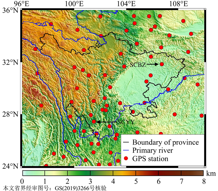
图 1
实验区的地形及GPS测站位置分布
Figure 1.
Topography of the test area and distribution of GPS stations
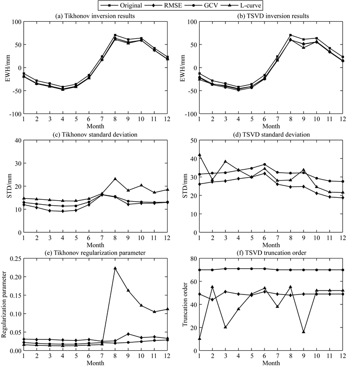
图 2
基于TSVD和Tikhonov正则化由不同正则化参数选取方法反演的TWSC(a和b)及其与原始信号的差值标准差(c和d)和相应的最优正则化参数与截断阶数(e和f)
Figure 2.
TWSC solved by Tikhonov and TSVD regularizations through different regularization parameter selection methods (a and b), STD of differences between the estimated TWSC and original signal (c and d), and the corresponding optimal regularization parameters and truncation orders (e and f)
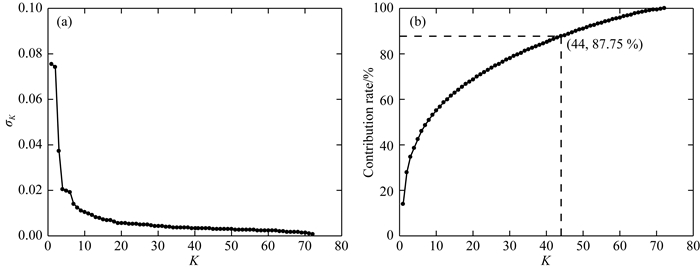
图 3
设计矩阵奇异值(a)和不同截断阶数对应的累积贡献率(b)
Figure 3.
Singular values of design matrix (a) and their cumulative contribution ratio (b) with different truncation orders
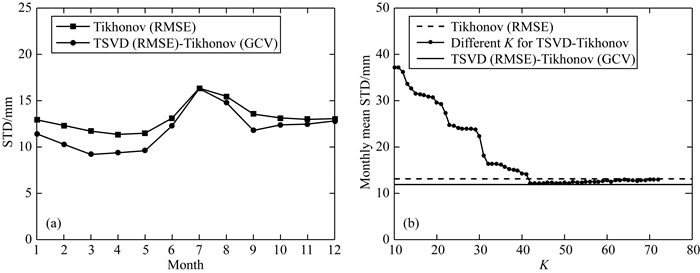
图 4
Tikhonov正则化和不同截断阶数K的TSVD-Tikhonov正则化反演结果的误差STD(a)和月平均误差STD(b)
Figure 4.
STD (a) and monthly mean STD (b) of the errors of the inversion results based on Tikhonov regularization and TSVD-Tikhonov regularization with different truncation order K
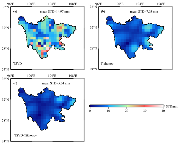
图 5
TSVD (a)、Tikhonov (b)和TSVD-Tikhonov (c)正则化反演的TWSC序列与原始信号差值STD的空间分布
Figure 5.
Spatial distributions of STD of the differences between the estimated TWSC series and original signal based on TSVD (a), Tikhonov (b), and TSVD-Tikhonov (c) regularizations
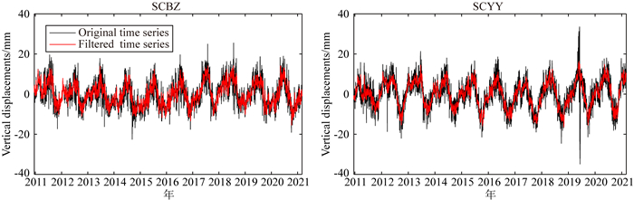
图 6
SCBZ和SCYY测站的垂直位移时间序列滤波前后比较
Figure 6.
Comparisons of the vertical displacement time series at SCBZ and SCYY stations before and after filtering
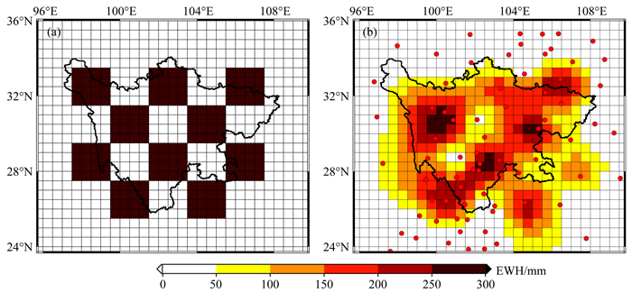
图 7
72个GPS测站恢复EWH信号的棋盘测试
Figure 7.
Checkerboard test of EWH signal recovered from 72 GPS stations
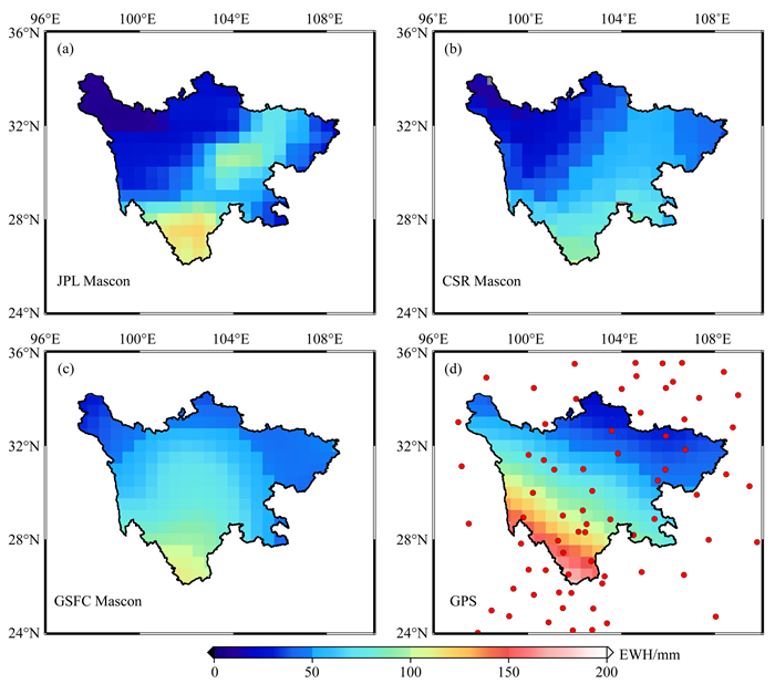
图 8
GRACE/GFO Mascon模型(JPL、CSR和GSFC)与GPS垂直位移反演的TWSC周年振幅空间分布
Figure 8.
Spatial patterns of annual amplitudes for TWSC derived from GRACE/GFO Mascons (JPL, CSR, and GSFC) and GPS vertical displacements

图 9
GRACE/GFO Mascon模型(JPL、CSR和GSFC)及其融合模型(GTCH-TWSC)与GPS垂直位移反演的TWSC时间序列比较
Figure 9.
Comparisons of TWSC time series derived from GRACE/GFO Mascons (JPL, CSR, and GSFC) and their fusion model (GTCH-TWSC), and GPS vertical displacements

图 10
不同类型水文气象数据计算的四川省月平均降水、蒸散发和径流变化(2011—2021年)
Figure 10.
Monthly average precipitation, evapotranspiration, and runoff changes of Sichuan Province derived from different hydrometeorology datasets (from 2011 to 2021)
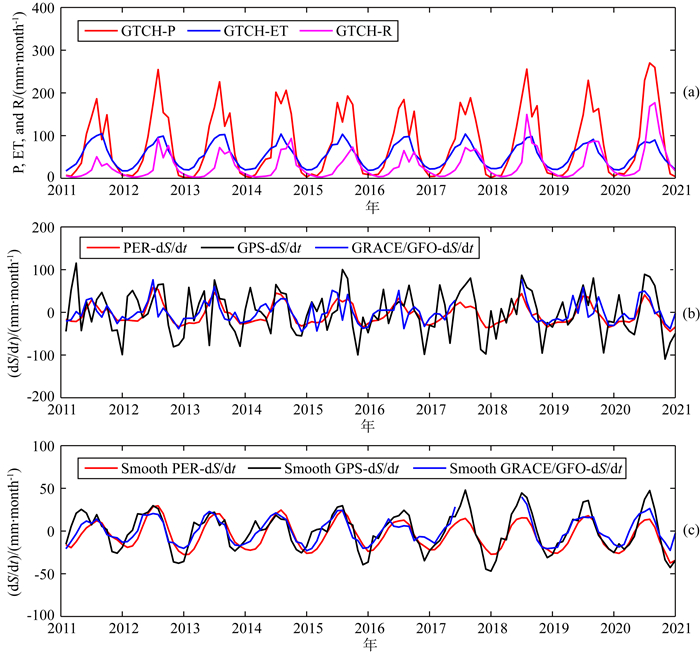
图 11
(a) GTCH方法融合后的降水、蒸散发和径流月平均时间序列;(b)和(c) 分别为平滑前后的PER-dS/dt、GPS-dS/dt和GRACE/GFO-dS/dt时间序列
Figure 11.
(a) Monthly average precipitation, evapotranspiration, and runoff time series fused by GTCH method; (b) and (c) are the PER-dS/dt, GPS-dS/dt, and GRACE/GFO-dS/dt time series before and after smoothing

图 12
平滑前后GPS-dS/dt和GRACE/GFO-dS/dt序列与PER-dS/dt序列之间的散点图及相关系数(CC)和差值STD比较
Figure 12.
Comparisons of scatter plot, correlation coefficient (CC), and STD of the differences between GPS-dS/dt, GRACE/GFO-dS/dt and PER-dS/dt series before and after smoothing
表 1
GRACE/GFO Mascon模型(JPL、CSR和GSFC)及其融合模型(GTCH-TWSC)与GPS反演的TWSC时间序列去除线性趋势后的相关系数和差值STD统计
Table 1.
Correlation coefficients and STD of the differences between TWSC time series derived from GPS and GRACE/GFO Mascons (JPL, CSR, and GSFC) and their fusion model (GTCH-TWSC) after removing linear trends
数据 相关系数 STD (mm) JPL 0.69 45.07 CSR 0.66 46.79 GSFC 0.67 45.85 GTCH-TWSC 0.69 45.04  下载: 导出CSV
表 2
GPS、GRACE/GFO Mascon模型(JPL、CSR和GSFC)及其融合模型(GTCH-TWSC)估计的TWSC时间序列的周年振幅、相位和线性趋势统计
Table 2.
Annual amplitudes, phases, and linear trends of TWSC time series estimated by GPS, GRACE/GFO Mascons (JPL, CSR, and GSFC) and their fusion model (GTCH-TWSC)
数据 时间范围 振幅(mm) 相位(months) 趋势(mm·a-1) GPS 2010-12—2021-02 70.98±8.19 9.16±0.22 -0.88±1.95 2010-12—2017-06 63.65±9.61 8.87±0.28 -1.95±3.55 2017-07—2021-02 88.44±12.08 9.58±0.26 -0.67±8.05 JPL 2010-12—2021-02 47.87±5.65 9.48±0.21 7.38±1.23 2010-12—2017-06 45.33±7.22 9.36±0.29 5.13±2.60 2018-06—2021-02 51.78±8.73 9.61±0.30 11.54±7.92 CSR 2010-12—2021-02 46.75±5.84 9.33±0.23 4.17±1.27 2010-12—2017-06 42.24±6.29 9.15±0.27 0.39±2.26 2018-06—2021-02 54.27±10.61 9.50±0.35 7.53±9.60 GSFC 2010-12—2021-02 57.85±6.53 9.00±0.20 5.84±1.42 2010-12—2017-06 55.62±8.05 8.92±0.26 2.75±2.89 2018-06—2021-02 61.30±11.15 9.08±0.32 6.87±10.05 GTCH-TWSC 2010-12—2021-02 49.41±5.42 9.29±0.20 5.67±1.18 2010-12—2017-06 46.15±6.39 9.16±0.25 2.58±2.29 2018-06—2021-02 54.65±9.17 9.43±0.30 8.79±8.29
下载: 导出CSV
表 3
不同类型时间序列数据的周年振幅和相位统计
Table 3.
Statistics of annual amplitudes and phases for the different types of time series datasets
数据集 序列名称 振幅(mm·month-1) 相位(months) GTCH融合数据 GTCH-P 98.34±6.45 7.11±0.12 GTCH-ET 37.77±1.33 6.77±0.07 GTCH-R 35.53±4.42 8.10±0.24 TWSC GPS-TWSC 70.46±8.32 9.18±0.23 GRACE/GFO-TWSC 45.71±5.72 9.21±0.24 dTWSC/dt PER-dS/dt 29.23±2.37 6.43±0.16 Smooth PER-dS/dt 21.80±1.13 6.42±0.10 GPS-dS/dt 36.49±8.78 5.69±0.46 Smooth GPS-dS/dt 28.08±2.80 5.68±0.20 GRACE/GFO-dS/dt 24.45±5.30 5.75±0.39 Smooth GRACE/ GFO-dS/dt 19.15±2.21 5.79±0.20
下载: 导出CSV
-
Argus D F, Fu Y N, Landerer F W. 2014. Seasonal variation in total water storage in California inferred from GPS observations of vertical land motion. Geophysical Research Letters, 41(6): 1971-1980. doi: 10.1002/2014GL059570
Argus D F, Landerer F W, Wiese D N, et al. 2017. Sustained water loss in California's mountain ranges during severe drought from 2012 to 2015 inferred from GPS. Journal of Geophysical Research: Solid Earth, 122(12): 10559-10585.
Blewitt G, Lavallée D, Clarke P, et al. 2001. A new global mode of Earth deformation: Seasonal cycle detected. Science, 294(5550): 2342-2345. doi: 10.1126/science.1065328
Borsa A A, Agnew D C, Cayan D R. 2014. Ongoing drought-induced uplift in the western United States. Science, 345(6204): 1587-1590. doi: 10.1126/science.1260279
Cazenave A, Chen J L. 2010. Time-variable gravity from space and present-day mass redistribution in the Earth system. Earth and Planetary Science Letters, 298(3-4): 263-274. doi: 10.1016/j.epsl.2010.07.035
Chen J L, Tapley B, Rodell M, et al. 2020. Basin-scale river runoff estimation from GRACE gravity satellites, climate models, and in situ observations: a case study in the Amazon Basin. Water Resources Research, 56(10): e2020WR028032, doi: 10.1029/2020WR028032.
Chen T Y, Kusche J, Shen Y Z, et al. 2020. A combined use of TSVD and Tikhonov regularization for mass flux solution in Tibetan Plateau. Remote Sensing, 12(12): 2045, doi: 10.3390/rs12122045.
Cheng S, Yuan L G, Jiang Z S, et al. 2021. Investigating terrestrial water storage change in Sichuan, Yunnan and Chongqing using Slepian basis functions. Chinese Journal of Geophysics (in Chinese), 64(4): 1167-1180, doi: 10.6038/cjg2021O0194.
Famiglietti J S, Lo M, Ho S L, et al. 2011. Satellites measure recent rates of groundwater depletion in California's Central Valley. Geophysical Research Letters, 38(3): L03403, doi: 10.1029/2010GL046442.
Farrell W E. 1972. Deformation of the Earth by surface loads. Reviews of Geophysics, 1972, 10(3): 761-797. doi: 10.1029/RG010i003p00761
Ferreira V G, Ndehedehe C E, Montecino H C, et al. 2019. Prospects for imaging terrestrial water storage in South America using daily GPS observations. Remote Sensing, 11(6): 679, doi: 10.3390/rs11060679.
Fu Y N, Argus D F, Landerer F W. 2015. GPS as an independent measurement to estimate terrestrial water storage variations in Washington and Oregon. Journal of Geophysical Research: Solid Earth, 120(1): 552-566. doi: 10.1002/2014JB011415
Galindo F J, Ruiz J J, Giachino E, et al. 2001. Estimation of the covariance matrix of individual standards by means of comparison measurements. //Ciarlini P, Filipe E, Pavese F, et al eds. Advanced Mathematical and Computational Tools in Metrology V. Singapore: World Scientific, 177-184.
Golub G H, Heath M, Wahba G. 1979. Generalized cross-validation as a method for choosing a good ridge parameter. Technometrics, 21(2): 215-223. doi: 10.1080/00401706.1979.10489751
Hansen P C. 1992. Analysis of discrete ill-posed problems by means of the L-curve. SIAM Review, 34(4): 561-580. doi: 10.1137/1034115
He S Y, Gu Y C, Fan D M, et al. 2018. Seasonal variation of terrestrial water storage in Yunnan province inferred from GPS vertical observations. Acta Geodaetica et Cartographica Sinica (in Chinese), 47(3): 332-340.
Heki K. 2001. Seasonal modulation of interseismic strain buildup in northeastern Japan driven by snow loads. Science, 293(5527): 89-92. doi: 10.1126/science.1061056
Huffman G J, Bolvin D T, Nelkin E J, et al. 2007. The TRMM multisatellite precipitation analysis (TMPA): Quasi-global, multiyear, combined-sensor precipitation estimates at fine scale. Journal of Hydrometeorology, 8(1): 38-55. doi: 10.1175/JHM560.1
Ji K P, Shen Y Z. 2020. Unbiased estimation of unit weight variance by TSVD regularization. Geomatics and Information Science of Wuhan University (in Chinese), 45(4): 626-632.
Jiang W P. 2017. Challenges and opportunities of GNSS reference station network. Acta Geodaetica et Cartographica Sinica (in Chinese), 46(10): 1379-1388. doi: 10.11947/j.AGCS.2017.20170424
Jiang W P, Yuan P, Chen H, et al. 2017. Annual variations of monsoon and drought detected by GPS: A case study in Yunnan, China. Scientific Reports, 7(1): 5874, doi: 10.1038/s41598-017-06095-1.
Jiang Z S, Hsu Y J, Yuan L G, et al. 2021a. Monitoring time-varying terrestrial water storage changes using daily GNSS measurements in Yunnan, southwest China. Remote Sensing of Environment, 254: 112249, doi: 10.1016/j.rse.2020.112249.
Jiang Z S, Hsu Y J, Yuan L G, et al. 2021b. Characterizing spatiotemporal patterns of terrestrial water storage variations using GNSS vertical data in Sichuan, China. Journal of Geophysical Research: Solid Earth, 126(12): e2021JB022398, doi: 10.1029/2021JB022398.
Jin S G, Zhang T Y. 2016. Terrestrial water storage anomalies associated with drought in southwestern USA from GPS observations. Surveys in Geophysics, 37(6): 1139-1156. doi: 10.1007/s10712-016-9385-z
Lai Y R, Wang L, Bevis M, et al. 2020. Truncated singular value decomposition regularization for estimating terrestrial water storage changes using GPS: a case study over Taiwan. Remote Sensing, 12(23): 3861, doi: 10.3390/rs12233861.
Landerer F W, Dickey J O, Güntner A. 2010. Terrestrial water budget of the Eurasian pan-Arctic from GRACE satellite measurements during 2003-2009. Journal of Geophysical Research: Atmospheres, 115(D23): D23115, doi: 10.1029/2010JD014584.
Li Q, Luo Z C, Zhong B, et al. 2013. Terrestrial water storage changes of the 2010 southwest China drought detected by GRACE temporal gravity field. Chinese Journal of Geophysics (in Chinese), 56(6): 1843-1849, doi: 10.6038/cjg20130606.
Li X P, Zhong B, Liu T. 2022. Simulation analysis of inverting regional surface mass variations using GNSS vertical displacement. Geomatics and Information Science of Wuhan University (in Chinese), 47(1): 45-54.
Liu N, Dai W J, Santerre R, et al. 2018. A MATLAB-based Kriged Kalman Filter software for interpolating missing data in GNSS coordinate time series. GPS Solutions, 22(1): 25, doi: 10.1007/s10291-017-0689-3.
Long D, Pan Y, Zhou J, et al. 2017. Global analysis of spatiotemporal variability in merged total water storage changes using multiple GRACE products and global hydrological models. Remote Sensing of Environment, 192: 198-216. doi: 10.1016/j.rse.2017.02.011
Loomis B D, Luthcke S B, Sabaka T J. 2019. Regularization and error characterization of GRACE mascons. Journal of Geodesy, 93(9): 1381-1398. doi: 10.1007/s00190-019-01252-y
Martens B, Miralles D G, Lievens H, et al. 2017. GLEAM v3: Satellite-based land evaporation and root-zone soil moisture. Geoscientific Model Development, 10(5): 1903-1925. doi: 10.5194/gmd-10-1903-2017
Miralles D G, Holmes T R H, De Jeu R A M, et al. 2011. Global land-surface evaporation estimated from satellite-based observations. Hydrology and Earth System Sciences, 15(2): 453-469. doi: 10.5194/hess-15-453-2011
Nikolaidis R. 2002. Observation of geodetic and seismic deformation with the Global positioning system[Ph. D. thesis]. San Diego: University of California.
Rodell M, Famiglietti J S. 1999. Detectability of variations in continental water storage from satellite observations of the time dependent gravity field. Water Resources Research, 35(9): 2705-2723. doi: 10.1029/1999WR900141
Rodell M, Houser P R, Jambor U, et al. 2004. The global land data assimilation system. Bulletin of the American Meteorological Society, 85(3): 381-394. doi: 10.1175/BAMS-85-3-381
Rodell M, Famiglietti J S, Wiese D N, et al. 2018. Emerging trends in global freshwater availability. Nature, 557(7707): 651-659. doi: 10.1038/s41586-018-0123-1
Save H, Bettadpur S, Tapley B D. 2016. High-resolution CSR GRACE RL05 mascons. Journal of Geophysical Research: Solid Earth, 121(10): 7547-7569. doi: 10.1002/2016JB013007
Shen Y F, Zheng W, Yin W J, et al. 2021. Inverted algorithm of terrestrial water-storage anomalies based on machine learning combined with load model and its application in southwest China. Remote Sensing, 13(17): 3358, doi: 10.3390/rs13173358.
Tavella P, Premoli A. 1994. Estimating the instabilities of N clocks by measuring differences of their readings. Metrologia, 30(5): 479-486. doi: 10.1088/0026-1394/30/5/003
Tikhonov A N. 1963. Solution of incorrectly formulated problems and the regularization method. Soviet Mathematics Doklady, 4: 1035-1038.
Wahr J, Khan S A, Van Dam T, et al. 2013. The Use of GPS Horizontals for Loading Studies, with Applications to Northern California and Southeast Greenland. Journal of Geophysical Research: Solid Earth, 118(4): 1795-1806. doi: 10.1002/jgrb.50104
Wang H S, Xiang L W, Jia L L, et al. 2012. Load love numbers and Green's functions for elastic earth models PREM, Iasp91, Ak135, and modified models with refined crustal structure from crust 2.0. Computers & Geosciences, 49: 190-199.
Watkins M M, Wiese D N, Yuan D N, et al. 2015. Improved methods for observing Earth's time variable mass distribution with GRACE using spherical cap mascons. Journal of Geophysical Research: Solid Earth, 120(4): 2648-2671, doi: 10.1002/2014JB011547.
Wiese D N, Landerer F W, Watkins M M. 2016. Quantifying and reducing leakage errors in the JPL RL05M GRACE mascon solution. Water Resources Research, 52(9): 7490-7502, doi: 10.1002/2016WR019344.
Yao C, Cong P, Wan J, et al. 2020. Spatio-temporal reductions of the COVID-19 lockdown-induced noise anomalies in GNSS height time series over mainland China. Remote Sensing Letters, 2020, 11(12): 1118-1126. doi: 10.1080/2150704X.2020.1825868
Yao C L, Li Q, Luo Z C, et al. 2019. Uncertainties in GRACE-derived terrestrial water storage changes over mainland China based on a generalized three-cornered hat method. Chinese Journal of Geophysics (in Chinese), 62(3): 883-897, doi: 10.6038/cjg2019L0454.
Zhao Q, Zhang B, Yao Y B, et al. 2019. Geodetic and hydrological measurements reveal the recent acceleration of groundwater depletion in North China Plain. Journal of Hydrology, 575: 1065-1072. doi: 10.1016/j.jhydrol.2019.06.016
Zhong B, Li X P, Chen J L, et al. 2020. Surface mass variations from GPS and GRACE/GFO: A case study in southwest China. Remote Sensing, 12(11): 1835, doi: 10.3390/rs12111835.
成帅, 袁林果, 姜中山等. 2021. 应用GPS数据和Slepian基函数反演川云渝地区陆地水储量变化. 地球物理学报, 64(4): 1167-1180, doi: 10.6038/cjg2021O0194. http://www.geophy.cn/article/doi/10.6038/cjg2021O0194
何思源, 谷延超, 范东明等. 2018. 利用GPS垂直位移反演云南省陆地水储量变化. 测绘学报, 47(3): 332-340. https://www.cnki.com.cn/Article/CJFDTOTAL-CHXB201803006.htm
嵇昆浦, 沈云中. 2020. TSVD正则化解法的单位权方差无偏估计. 武汉大学学报·信息科学版, 45(4): 626-632. https://www.cnki.com.cn/Article/CJFDTOTAL-WHCH202004019.htm
姜卫平. 2017. 卫星导航定位基准站网的发展现状、机遇与挑战. 测绘学报, 46(10): 1379-1388. doi: 10.11947/j.AGCS.2017.20170424
李琼, 罗志才, 钟波等. 2013. 利用GRACE时变重力场探测2010年中国西南干旱陆地水储量变化. 地球物理学报, 56(6): 1843-1849, doi: 10.6038/cjg20130606. http://www.geophy.cn/article/doi/10.6038/cjg20130606
李贤炮, 钟波, 刘滔. 2022. GNSS垂直位移反演区域地表质量变化的模拟分析. 武汉大学学报·信息科学版, 47(1): 45-54. https://www.cnki.com.cn/Article/CJFDTOTAL-WHCH202201004.htm
姚朝龙, 李琼, 罗志才等. 2019. 利用广义三角帽方法评估GRACE反演中国大陆地区水储量变化的不确定性. 地球物理学报, 62(3): 883-897, doi: 10.6038/cjg2019L0454. http://www.geophy.cn/article/doi/10.6038/cjg2019L0454
-
图(12)
表(3)
计量
- 文章访问数: 3264
- PDF下载数: 202
- 施引文献: 0