
Mantle transition zone beneath northeast China imaged by receiver function data using fast marching eikonal solver based 3-D migration
-
摘要:
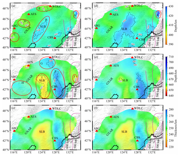
本文利用中国东北地区NECESSArray记录到的45505条接收函数,结合该区域最新三维速度模型,采用快速行进法求解程函方程,计算了P-S转换波相对走时,并通过共转换点叠加成像方法获得了该地区下方地幔间断面起伏情况.结果显示,在长白山—五大连池连线一带东西约300 km,南北约900 km的狭长形区域内,660-km间断面下陷幅度达20~40 km.其结构可细分为南北两部分,南部更为狭窄且与日本海沟走向一致,对应于从日本海沟俯冲的太平洋板块在地幔过渡带的滞留区;北部对应于从千岛海沟俯冲的太平洋板块在地幔过渡带的滞留区.同时,在长白山西部,存在与长白山—五大连池下陷区形状类似的南北向狭长形抬升区,660-km间断面抬升幅度约为10 km,显示俯冲太平洋板块只延伸至松辽盆地东侧;而在盆地西侧,660-km间断面的下陷区可能与该地区岩石圈拆沉有关.同时,410-km间断面在松辽盆地—渤海一带,以及长白山火山西南和东北方向存在明显的下陷区;另外,在阿巴嘎及阿尔山也有小范围的下陷区.所有这些下陷区,均与地表新生代火山活动区/拉伸区有很好的对应关系,表明这些地表构造与深部热物质上涌有关.
Abstract:In this study, we utilized 45505 teleseismic receiver functions derived from NECESSArray records to image the mantle transition zone beneath northeast China. We employed a fast-marching technique to solve the eikonal equations of the direct P wave and P-to-S converted waves in a 3-D velocity model. We selected the high-resolution 3-D model of FWEA18 that was derived from full waveform inversion as the reference velocity model. We gathered the receiver functions based on their geographical locations and stacked the receiver functions with a common conversion point (CCP). We found clear P-to-S conversion associated with the 410-km and 660-km discontinuities that define, respectively, the upper and lower boundaries of the mantle transition zone. The 660-km discontinuity deepens by 20~40 km in a~300 km by~900 km elongated area extending roughly in the north-south (NS) direction beneath the Changbaishan-Wudalianchi area. The southern and northern parts of the depression area show a distinct difference that suggests that the Pacific plate subducted from the Japan and Kuril trenches has different morphology when it encounters the upper and lower mantle boundary. The western front of the trough lies a N-S oriented uplift area with an elevation of~10 km. These observations suggest that the subducted Pacific oceanic lithosphere only reaches to the eastern side of the Songliao Basin. We also observe a mild depression of 660-km beneath the Great Xing'An Range west to the Songliao Basin, which is likely caused by a delaminated continental lithosphere. Overall, the 410-km discontinuity appears to be flatter than the 660-km. It deepens slightly beneath the Songliao Basin, Bohai, the southwest and northeast sides of the Changbaishan volcano, the Abaga and Arshan volcanic regions. These depressions correspond well with extensional and volcanic regions, suggesting magmatism in the study area is largely controlled by ascending hot material from great depths.
-
Key words:
- Northeast China /
- Receiver function /
- Mantle transition zone /
- Cenozoic volcanoes /
- Subduction zone
-

-
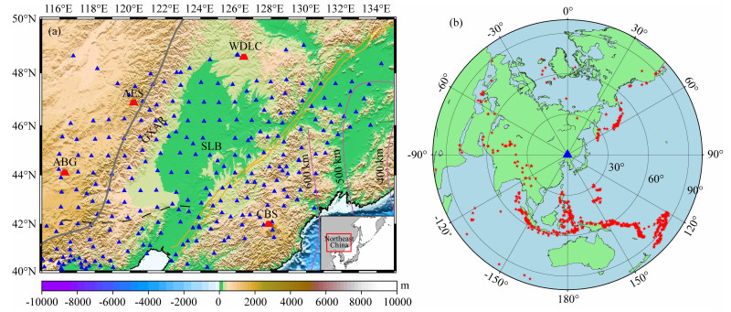
图 1
中国东北地形与台站分布图及震中位置分布图
Figure 1.
Topography and distribution of stations and epicenter locations in northeast China

图 2
FM法计算相对走时示意图
Figure 2.
Illustration of the FM method for calculating relative traveltimes
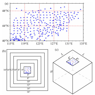
图 3
子区域划分与走时场范围示意图
Figure 3.
Illustration of sub-area division and traveltime field range

图 4
一维模型中P410s和P660s相对走时差计算结果
Figure 4.
Relative traveltime differences of P410s and P660s in the 1-D model
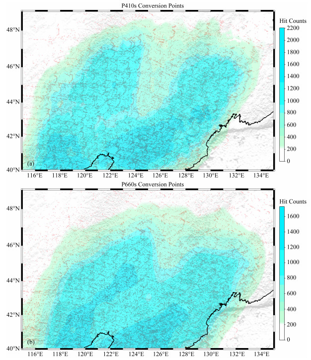
图 5
P410s和P660s转换点位置分布图
Figure 5.
Distribution of conversion point locations for P410s and P660s

图 7
(a) 三维S波速度模型剖面中直达P波与转换P410s波射线路径. 红色和蓝色实线代表在一维速度模型中通过射线追踪分别求出的直达P波和转换P410s波射线路径;红色和蓝色虚线代表在三维速度模型中分别求出的直达P波和转换P410s波射线路径. 黑色虚线表示410-km和660-km深度位置. (b)展示了基于FM法,使用三维速度模型中的转换点地理位置求出的P410s相对走时,与使用一维速度模型中转换点地理位置求出的P410s相对走时之差的统计结果
Figure 7.
(a) Direct P-wave and converted P410s ray paths in the 3-D S-wave velocity model profile. The red and blue solid lines represent the direct P-wave and converted P410s ray paths derived by ray tracing in the 1-D velocity model; the red and blue dashed lines represent the direct P-wave and converted P410s ray paths in the 3-D velocity model. The black dashed lines indicate the positions of 410-km and 660-km. (b) shows the statistical results of the difference between the relative traveltime of P410s based on FM method by using the geographic location of the converted points in the 3-D and 1-D velocity models

图 9
(a) 地表地形起伏示意图. 浅蓝色表示海平面以下;红色三角形表示长白山火山群. (b)红色与蓝色虚线分别表示对应地理位置410-km和660-km间断面参与叠加的接收函数数量;黑色虚线的位置表示叠加数量为200条.(c)沿北纬42°的CCP叠加深度剖面. 黑色虚线分别表示410-km和660-km深度位置;红色表示转换波振幅大于0的部分
Figure 9.
(a) Topographic relief map. The light blue color indicates below sea level; the red triangle indicates the Changbaishan Volcanic zones. (b) The red and blue dashed lines represent the number of receiver function involved at the corresponding geographic locations of 410-km and 660-km discontinuity, respectively; the position of the black dashed line indicates the number of receiver function involved in stacking is 200. (c) The depth profile along 42°N. The black dashed lines indicate the position of 410 km and 660 km, respectively; the red color represents the part of the conversion wave with amplitude greater than 0
-
Ai Y S, Zheng T Y, Xu W W, et al. 2003. A complex 660 km discontinuity beneath northeast China. Earth and Planetary Science Letters, 212(1-2): 63-71, doi: 10.1016/S0012-821X(03)00266-8.
Ai Y S, Zheng T Y, Xu W W, et al. 2008. Small scale hot upwelling near the North Yellow Sea of eastern China. Geophysical Research Letters, 35(20): L20305, doi: 10.1029/2008GL035269.
Bijwaard H, Spakman W, Engdahl E R. 1998. Closing the gap between regional and global travel time tomography. Journal of Geophysical Research: Solid Earth, 103(B12): 30055-30078, doi: 10.1029/98JB02467.
Cammarano F, Goes S, Vacher P, et al. 2003. Inferring upper-mantle temperatures from seismic velocities. Physics of the Earth and Planetary Interiors, 138(3-4): 197-222, doi: 10.1016/S0031-9201(03)00156-0.
Chen Y, Zhang Y X, Graham D, et al. 2007. Geochemistry of Cenozoic basalts and mantle xenoliths in Northeast China. Lithos, 96(1-2): 108-126, doi: 10.1016/j.lithos.2006.09.015.
Cheng C, Bodin T, Allen R M. 2016. Three-dimensional pre-stack depth migration of receiver functions with the fast marching method: a Kirchhoff approach. Geophysical Journal International, 205(2): 819-829, doi: 10.1093/gji/ggw062.
DeKool M, Rawlinson N, Sambridge M. 2006. A practical grid-based method for tracking multiple refraction and reflection phases in three-dimensional heterogeneous media. Geophysical Journal International, 167(1): 253-270, doi: 10.1111/j.1365-246X.2006.03078.x.
Du X J, Meng L S, Zhang M R. 2009. Research on fault distribution and tectonic divisions in Northeast China in terms of gravity field. Journal of Earth Sciences and Environment (in Chinese), 31(2): 200-206, doi: 10.3969/j.issn.1672-6561.2009.02.014.
Duan Y H, Zhao D P, Zhang X K, et al. 2009. Seismic structure and origin of active intraplate volcanoes in Northeast Asia. Tectonophysics, 470(3-4): 257-266, doi: 10.1016/j.tecto.2009.01.004.
Dueker K G, Sheehan A F. 1997. Mantle discontinuity structure from midpoint stacks of converted P to S waves across the Yellowstone hotspot track. Journal of Geophysical Research: Solid Earth, 102(B4): 8313-8327, doi: 10.1029/96JB03857.
Fan Q C, Hooper P R. 1991. The Cenozoic basaltic rocks of eastern China: petrology and chemical composition. Journal of Petrology, 32(4): 765-810, doi: 10.1093/petrology/32.4.765.
Fei Y, Van Orman J, Li J, et al. 2004. Experimentally determined postspinel transformation boundary in Mg2SiO4 using MgO as an internal pressure standard and its geophysical implications. Journal of Geophysical Research: Solid Earth, 109(B2): B02305, doi: 10.1029/2003JB002562.
Fukao Y, Obayashi M, Inoue H, et al. 1992. Subducting slabs stagnant in the mantle transition zone. Journal of Geophysical Research, 97(B4): 4809, doi: 10.1029/91JB02749.
Gilbert H J, Sheehan A F, Dueker K G, et al. 2003. Receiver functions in the western United States, with implications for upper mantle structure and dynamics. Journal of Geophysical Research: Solid Earth, 108(B5): 2229, doi: 10.1029/2001JB001194.
Guan Z, Niu F L. 2018. Using fast marching eikonal solver to compute 3-D Pds traveltime for deep receiver-function imaging. Journal of Geophysical Research: Solid Earth, 123(10): 9049-9062, doi: 10.1029/2018JB015892.
Harte B. 2010. Diamond formation in the deep mantle: the record of mineral inclusions and their distribution in relation to mantle dehydration zones. Mineralogical Magazine, 74(2): 189-215, doi: 10.1180/minmag.2010.074.2.189.
Helffrich G. 2000. Topography of the transition zone seismic discontinuities. Reviews of Geophysics, 38(1): 141-158, doi: 10.1029/1999RG000060.
Helffrich G R, Wood B J. 2001. The Earth′s mantle. Nature, 412(6846): 501-507, doi: 10.1038/35087500.
Higo Y, Inoue T, Irifune T, et al. 2001. Effect of water on the spinel-postspinel transformation in Mg2SiO4. Geophysical Research Letters, 28(18): 3505-3508, doi: 10.1029/2001GL013194.
Huang J L, Zhao D P. 2006. High-resolution mantle tomography of China and surrounding regions. Journal of Geophysical Research: Solid Earth, 111(B9): B09305, doi: 10.1029/2005JB004066.
Ito E, Takahashi E. 1989. Postspinel transformations in the system Mg2SiO4-Fe2SiO4 and some geophysical implications. Journal of Geophysical Research: Solid Earth, 94(B8): 10637-10646, doi: 10.1029/JB094iB08p10637.
Katsura T, Ito E. 1989. The system Mg2SiO4-Fe2SiO4 at high pressures and temperatures: Precise determination of stabilities of olivine, modified spinel, and spinel. Journal of Geophysical Research: Solid Earth, 94(B11): 15663-15670, doi: 10.1029/JB094iB11p15663.
Katsura T, Yamada H, Nishikawa O, et al. 2004. Olivine-wadsleyite transition in the system (Mg, Fe)2SiO4. Journal of Geophysical Research, 109(B2): 105-122, doi: 10.1029/2003JB002438.
Lei J S, Zhao D P. 2005. P-wave tomography and origin of the Changbai intraplate volcano in Northeast Asia. Tectonophysics, 397(3-4): 281-295, doi: 10.1016/j.tecto.2004.12.009.
Lei J S, Zhao D P. 2006. Global P-wave tomography: On the effect of various mantle and core phases. Physics of the Earth and Planetary Interiors, 154(1): 44-69, doi: 10.1016/j.pepi.2005.09.001.
Lei J S, Xie F R, Fan Q C, et al. 2013. Seismic imaging of the deep structure under the Chinese volcanoes: An overview. Physics of the Earth and Planetary Interiors, 224: 104-123, doi: 10.1016/j.pepi.2013.08.008.
Li C, Van Der Hilst R D. 2010. Structure of the upper mantle and transition zone beneath Southeast Asia from traveltime tomography. Journal of Geophysical Research: Solid Earth, 115(B7): B07308, doi: 10.1029/2009JB006882.
Li X Q, Yuan X H. 2003. Receiver functions in northeast China- implications for slab penetration into the lower mantle in northwest Pacific subduction zone. Earth and Planetary Science Letters, 216(4): 679-691, doi: 10.1016/S0012-821X(03)00555-7.
Litasov K D, Ohtani E, Sano A, et al. 2005. Wet subduction versus cold subduction. Geophysical Research Letters, 32 (13), doi: 10.1029/2005gl022921.
Liu J Q. 1999. Volcanoes in China (in Chinese). Beijing: Science Press.
Liu J Q, Han J T, Fyfe W S. 2001. Cenozoic episodic volcanism and continental rifting in northeast China and possible link to Japan Sea development as revealed from K-Ar geochronology. Tectonophysics, 339(3-4): 385-401, doi: 10.1016/S0040-1951(01)00132-9.
Liu Z, Niu F L, Chen Y J, et al. 2015. Receiver function images of the mantle transition zone beneath NE China: New constraints on intraplate volcanism, deep subduction and their potential link. Earth and Planetary Science Letters, 412: 101-111, doi: 10.1016/j.epsl.2014.12.019.
Pearson D G, Brenker F E, Nestola F, et al. 2014. Hydrous mantle transition zone indicated by ringwoodite included within diamond. Nature, 507(7491): 221-224, doi: 10.1038/nature13080.
Popovici A M, Sethian J A. 2002. 3-D imaging using higher order fast marching traveltimes. Geophysics, 67(2): 604-609, doi: 10.1190/1.1468621.
Rawlinson N, Sambridge M. 2004a. Multiple reflection and transmission phases in complex layered media using a multistage fast marching method. Geophysics, 69(5): 1338-1350, doi: 10.1190/1.1801950.
Rawlinson N, Sambridge M. 2004b. Wave front evolution in strongly heterogeneous layered media using the fast marching method. Geophysical Journal International, 156(3): 631-647, doi: 10.1111/j.1365-246X.2004.02153.x.
Sethian J A. 1996. A fast marching level set method for monotonically advancing fronts. Proceedings of the National Academy of Sciences, 93(4): 1591-1595, doi: 10.1073/pnas.93.4.1591.
Sethian J A, Popovici A M. 1999. 3-D traveltime computation using the fast marching method. Geophysics, 64(2): 516-523, doi: 10.1190/1.1444558.
Tang Y C, Obayashi M, Niu F L, et al. 2014. Changbaishan volcanism in Northeast China linked to subduction-induced mantle upwelling. Nature Geoscience, 7(6): 470-475, doi: 10.1038/NGEO2166.
Tao K, Grand S P, Niu F L. 2018. Seismic structure of the upper mantle beneath Eastern Asia from full waveform seismic tomography. Geochemistry, Geophysics, Geosystems, 19(8): 2732-2763, doi: 10.1029/2018GC007460.
Thompson A B. 1992. Water in the Earth′s upper mantle. Nature, 358(6384): 295, doi: 10.1038/358295a0.
Tian Y, Zhu H, Zhao D, et al. 2016. Mantle transition zone structure beneath the Changbai volcano: Insight into deep slab dehydration and hot upwelling near the 410 kmdiscontinuity. Journal of Geophysical Research: Solid Earth, 121(8): 5794-5808, doi: 10.1002/2016JB012959.
Wei W, Xu J D, Zhao D P, et al. 2012. East Asia mantle tomography: New insight into plate subduction and intraplate volcanism. Journal of Asian Earth Sciences, 60: 88-103, doi: 10.1016/j.jseaes.2012.08.001.
Wei W, Zhao D P, Xu J D, et al. 2015. P and S wave tomography and anisotropy in Northwest Pacific and East Asia: Constraints on stagnant slab and intraplate volcanism. Journal of Geophysical Research: Solid Earth, 120(3): 1642-1666, doi: 10.1002/2014JB011254.
Yang F, Zhang H, Li J, et al. 2021. Topography of mantle transition zone discontinuities beneath Northeast China imaged by receiver function with Ps scattering kernel. Chinese Journal of Geophysics (in Chinese), 64(12): 4406-4424, doi: 10.6038/cjg2021P0213.
Zhang R Q, Gao Z Y, Wu Q J, et al. 2016. Seismic images of the mantle transition zone beneath Northeast China and the Sino- Korean craton from P-wave receiver functions. Tectonophysics, 675: 159-167, doi: 10.1016/j.tecto.2016.03.002.
Zhao D P. 2004. Global tomographic images of mantle plumes and subducting slabs: insight into deep Earth dynamics. Physics of the Earth and Planetary Interiors, 146(1-2): 3-34, doi: 10.1016/j.pepi.2003.07.032.
Zhao D P, Maruyama S, Omori S. 2007. Mantle dynamics of Western Pacific and East Asia: Insight from seismic tomography and mineral physics. Gondwana Research, 11(1-2): 120-131, doi: 10.1016/j.gr.2006.06.006.
Zhao D P, Tian Y, Lei J S, et al. 2009. Seismic image and origin of the Changbai intraplate volcano in East Asia: Role of big mantle wedge above the stagnant Pacific slab. Physics of the Earth and Planetary Interiors, 173(3-4): 197-206, doi: 10.1016/j.pepi.2008.11.009.
Zhou C Y, Jin Z M, Zhang J F. 2010. Mantle transition zone: An important field in the studies of Earth′s deep interior. Earth Science Frontiers (in Chinese), 17(3): 90-113.
Zhou J B, Wilde S A. 2013. The crustal accretion history and tectonic evolution of the NE China segment of the Central Asian Orogenic Belt. Gondwana Research, 23(4): 1365-1377, doi: 10.1016/j.gr.2012.05.012.
Zhu L P. 2000. Crustal structure across the San Andreas Fault, southern California from teleseismic converted waves. Earth and Planetary Science Letters, 179(1): 183-190, doi: 10.1016/S0012-821X(00)00101-1.
Zou H B, Fan Q C, Yao Y P. 2008. U-Th systematics of dispersed young volcanoes in NE China: Asthenosphere upwelling caused by piling up and upward thickening of stagnant Pacific slab. Chemical Geology, 255(1-2): 134-142, doi: 10.1016/j.chemgeo.2008.06.022.
杜晓娟, 孟令顺, 张明仁. 2009. 利用重力场研究东北地区断裂分布及构造分区. 地球科学与环境学报, 31(2): 200-206, doi: 10.3969/j.issn.1672-6561.2009.02.014.
刘嘉麒. 1999. 中国火山. 北京: 科学出版社.
杨凡, 张涵, 李娟等. 2021. 利用接收函数散射核方法探测中国东北地区地幔转换带界面三维形态. 地球物理学报, 64(12): 4406-4424, doi: 10.6038/cjg2021P0213. http://www.igg-journals.cn/article/doi/10.6038/cjg2021P0213
周春银, 金振民, 张军峰. 2010. 地幔转换带: 地球深部研究的重要方向. 地学前缘, 17(3): 90-113. https://www.cnki.com.cn/Article/CJFDTOTAL-DXQY201003010.htm
-
 下载:
下载:

图(9)
计量
- 文章访问数: 3150
- PDF下载数: 196
- 施引文献: 0