Application of Spatial Techniques for the Identification of Discontinuous Aquifers of the Basement in Semi-Arid Environment: A Case of Bagzan Mount Plateau, Aïr Massif (North, Niger) ()
1. Introduction
Metamorphic, plutonic and some volcanic rocks have low matrix permeability. In these rocks, fracturing and weathering determine the existence of aquifers in Precambrian basement areas [1] . Knowledge of basement aquifers requires the identification of fractured and altered areas that constitute the privileged places of infiltration, likely to store and facilitate the flow of water. Several studies have been conducted in the West African basement and have shown the importance of the study of fracturing in the identification of discontinuous aquifers in the basement.
In West Africa, for a long time, the exploitation of the aquifers of the basement was limited to the capture of the layers of alternates by ignorance of the appreciable hydraulic role of the fracturing [2] . It was not until the 1970s that fractured aquifers under the alterites were identified [3] [4] . In the basement area, the flow of water is mainly in the fractures and as a result, it is a privileged means of orientation of groundwater exploration. The study of fracturing is, therefore, essential for the research of groundwater resources in the crystalline and crystallophyllian zones [5] [6] [7] [8] [9] . The use of spatial techniques such as remote sensing is a reliable approach to detect fractures in geological formations. Thus, it is generally used for the characterization of basement aquifers in West Africa. Several studies [10] [11] [12] [13] [14] relating to the application of remote sensing to characterize basement fracturing resulted in: 1) evidence of the importance of hydrogeological fracturing and 2) significant reduction in the failure rate of drilling.
In Niger, few authors have been interested in studying the hydrogeological role of fracturing in cristallin basements related to groundwater exploration [7] [8] [14] [15] [16] . These studies show that the boreholes drilled near of faults are much more productive than those that are distant [8] [14] , and the fracturing map from the work of [7] [15] [16] has been an important tool for decision-making in groundwater research in basement formation of Liptako and Aïr massif.
In the Aïr massif, particularly in Bagzan, which is the highest peak in Niger (2020 m) of altitude, no study has been conducted on the hydrogeological to characterize groundwater and importance of fracturing and alteration. The basement is almost flush on this massif limiting the infiltration and storage of water. This indicates that only fractures in relation to the areas of accumulation of runoff have the ability to be drained of water.
Bagzan mount, there are two hydrogeological reservoirs [17] . That of the basement is characterized by weak hydrodynamic parameters [18] associated with the presence of draining source fractures. The second reservoir consists of the clay-sandy alluvial formations of the valley. It is the most important because of its appreciable storage capacity [19] . However, the latter reservoir is subject to anthropogenic constraints and climate severity. The study of mountain aquifers requires specific and diverse approaches because their context differs from that of sedimentary basins.
Local aquifers in mountainous regions. In these areas, the hydrogeological formations are very fragmented by tectonic deformations and accidents. They are generally only small local aquifers. However, they are significant resources. Local aquifers of ancient massifs are located in particular hydrogeological structures [20] .
The influence of the exploitation and the climate participates strongly in the renewal of these reservoirs. The multidisciplinary methods of aquifer recognition in crystalline and cristallophyllian mediums are multiple. The essential of the water resource on Bagzan mount is represented by the aquifers contained in basaltic formations and in the alluvium of the valleys. These waters are used for irrigation and livestock. In recent years, with climate variability, this area has recorded water supply difficulties. Moreover, these resources have rarely been studied. This study aims to improve hydrogeological knowledge of fractured aquifers of Bagzan mount through the mapping of fractures that may constitute potential areas of accumulation of groundwater.
2. Material and Methods
2.1. Presentation of the Study Area
Bagzan mount (Figure 1), is located in the southern part of Air between 17˚33'26.68" and 17˚54'19.46" of northern latitude and 08˚40'57.81" and 8˚46'18.7" of eastern longitude. With an area of about 600 km2 with a maximum altitude of 2020 m [21] , Bagzan mount forms a vast plateau dominated by volcanic and granite, with an oval shape with a north-south orientation of approximately 40 km in length and longitudinal extension of approximately 20 km [22] . It is delimited by two mountain ranges including Taraouaji to the southwest and Iskou to the northeast.
The climate of the Bagzan area, is of the desert tropical mountain type with a
microclimate due to the effect of altitude [23] .
Temperatures are lower than in the surrounding areas due to the effect of altitude [21] . In September, they range from 16˚C to 33˚C while in Agadez they can vary from 23˚C to 40˚C. The average annual temperature is between 15˚C and 30˚C with an average value of 9˚C in the cold season and these minimum values can fall below 0˚C.
The climate is arid with very irregular annual rainfall ranging from 10 to 150 mm/year and an average of 70 mm/year [24] . Bagzan mount receives more precipitation than the rest of Air and is on average about 190 mm/year [24] and can reach 400 mm/year.
2.2. Geology and Hydrogeology of the Study Area
Aïr massif is a south-eastern appendix of the Tuareg Shield (Figure 2). It consists of three main domains which are from West to East: 1) the Assodé domain, framed by two NS accidents: the Arlit fault in the West and the Raghane
![]()
Figure 2. Geological context of the study area (modified from [18] ).
accident in the East; 2) the Barghot domain; and 3 Aouzegueur domain [25] [26] . The basement is made of old granites, gneiss, micaschists and marble, intruded by ring complexes of “young granites” [27] . This ring-shaped complex constitutes the different mountains of the locality, elongated along an N-S axis. Bagzan mount is part of these mountains. These annular complexes [27] [28] , considered as “anorogenic” find their equivalence in the Damagarm-Mounio [29] [30] and dans secteur de Jos [31] [32] .
Bagzan mount is part of the granite ring complexes [30] . These are circular or oval granitic plateaus with tabular tops and steep slopes that were set up through annular faults such as that of hyperalkaline granites type Bagzan [30] . Rhyolites preserved by collapse inside the massif are vestiges of volcanism representing the first magmatic manifestation [30] . The structure of the massif, difficult to detect due to partial intrusions of granitic inflows, seems to be controlled by three oval-shaped nested annular faults along which a syenite is mounted. These faults are located: 1) along the outer limit of the massif [30] , 2) southwest of the Bagzan where one of them delimits an oval measuring 20 km by 12 km underlined by the syenitic ring vein of Essengui and 3) inside the ring of Essingui with a diameter of 4 km.
Four accidents families cut the massif according to the directions NO-SE, N80˚, N45˚ and N120˚-N150˚ [7] [33] .
Aquifers can be distributed as in the Aïr massif, in the following order: 1) the first is represented by the fractured/altered basement and is characterized by low porosity and transmissivity [18] . However, several springs flow through majors’ geological accidents or at their crossings as well in the contact areas of different magmatic lithology. 2) The second aquifer is represented by the clay-sandy formations of the alluvium of the valleys which constitute the most important reservoir because of its storage capacity, it is however reduced in volume [18] . Finally, 3) the third consists of a volcanic ensemble consisting of alternating flows of altered volcanic rocks and clay levels recognized as a pre-caldera series [34] .
These aquifers are captured by modern and traditional cemented wells of shallow depths of about 12 m depending on the places for the water supply of the populations and for the agricultural activities. The village of Emalawlé, for example, is fed by a permanent spring that has been built for this purpose.
2.3. Methods
2.3.1. Database
The cartographic database used for this study includes a Digital Elevation Model (DEM, MNT, resolution 30 m, scenes: 17-008 and 17-009, SRTM 30 M, NASA, USGS/2014).
A topographic map of the Bagzan area [30] (Elmeki sheet NE-32-X) at 1/200,000 and a geological map of Aïr [30] at 1/500,000.
The tools are mainly composed of remote sensing software (Envi 5.1), GIS (ArcGIS 10.3) and lineament processing (Linwin). The various operations that enabled the operation of the DEM are presented in the organigram (Figure 3).
![]()
Figure 3. Flowchart of the different treatments applied to DEM.
2.3.2. Pretreatment
Image pretement is based on correction of radiometric and geometric alterations received during loading. In the desert regions, atmospheric conditions are acceptable with clear skies, image have not need to be corrected. Geometric correction was made from four hydraulic wells (calibration points) found on the topographic map.
Thus, this correction is image to card type. Then, a polynomial rectification of degree 2 and a re-sampling by the bilinear interpolation method were performed. The DEM image-to-image correction was performed from five calibration points from the corrected DEM bands. The polynomial transformation of degree 1, and a re-sampling by the cubic convolution method were applied to these five calibration points. The Mean Residual Error (RMS) value for DEM is 0.218 m compared to the demi-pixel (15 m). These errors are smaller than this one, so the correction is acceptable [7] [35] . Finally, all these numerical data were projected in the same datum (WGS 84).
2.3.3. Hillshad
The treatment of the Digital Elevation Model (DEM) consisted in achieving the blurring. The latter is a classic mapping technique, which consists in representing the effect of relief by illuminating the model in a defined direction and thus making shadows appear forming a monochrome image [7] [36] .
In this study, the DEM was dimmed in four directions (N045˚, N090˚, N135˚ a N180˚) to emphasize the structural directions perpendicular to them (NO-SE, N-S, NE-SO and E-O). On the DEM resulting from this treatment, in addition to the structural alignments, relief and hollow shapes are taken into account in the mapping. The second type of DEM treatment was facet orientation. Figure 4 illustrates the different treatments applied.
2.3.4. Manual Extraction of Lineament
Manual extraction of lineaments is based on visual observation by photo-interpretation [7] [8] [14] . This manual extraction consists in drawing the segments corresponding to the discontinuities and the sudden variations of tone observed on the images thus treated. These are mainly the hydrographic network, slope breaks, and geological alignments or contacts. In this work, this last method was used.
2.3.5. Validation of Fracturing Map
The validation stage of fractures resulting from the digital treatment of NTM is fundamental [37] [38] [39] .
The structures highlighted from the DEM were compared with those of the accidents represented on the geological map [25] [30] to validate the lineaments in order to give them a structural meaning.
However, on the geological map the density of faults is very low. Therefore, the second validation approach was carried out by checking these structures in the field. Several water springs were mapped in the study area. The fact that the majority of these springs water are located at the junction of the fractures suggests that its structures are of tectonic origin.
![]()
Figure 4. (a) Hillshad image; (b) Manual extraction of lineaments.
3. Results and Discussion
3.1. Results
3.1.1. Directional Distribution of Fractures from DEM
Table 1 gives the percentage of fractures in number and cumulative lengths from DEM. It appears that in number of fractures, four main directions are observed, these are: N0˚-N10˚ (13%), N60˚-N70˚ (12%), N90˚-N100˚ (11%), N70˚-N80˚ (10%), N80˚-N90˚ and N50˚-N60˚ (7%). The directions N30˚-N40˚ and N100˚-N110˚ (6%), other directions have a percentage below 5%.
The analysis of the lengths cumulative fractures (Table 1) show that the orientations N60˚-N70˚ (23%), N70˚-N80˚ (20%), N90˚-N100˚ (8%), N50˚-N60˚ and N0˚-N10˚ (6%) have a high percentage. As for the other directions, their percentage is less than 5%.
3.1.2. Directional Distribution of Fractures from Geological Map
The distribution (Table 2) of the directions in number of fractures from geological map, allows to identify five major directions. These are: N70˚-N80˚ (17%), N60˚-N70˚ (14%), N50˚-N60˚ (12%), N90˚-N100˚ (9%) and N80˚-N90˚ (8%), the other are below 5%.
For the cumulative length of fractures, the most important directions are: N70˚-N80˚ (28%), N60˚-N70˚ (13%), N50˚-N60˚ (10%), N130˚-N140˚ (8%), N80˚-N90˚ (8%), N120˚-N130˚ (7%), and N40˚-N80˚ (6%). For other directions, their percentage is below 5%.
3.1.3. Directional Distribution of Fractures from Field
In the field the measured directions are mainly N70˚-N90˚ (62.5%) and N10˚-N20˚ (37.5%). however, the N70˚-N90˚ directions are wide and are observed over long distances, such as the Ighalablaben fault, with the presence of several springs. Because of the depth of this fault, almost the majority of the
![]()
Table 1. Percentage of fractures in number and cumulative lengths from DEM (N = 307).
![]()
Table 2. Percentage of fractures in number and cumulative lengths from geological map (N = 207).
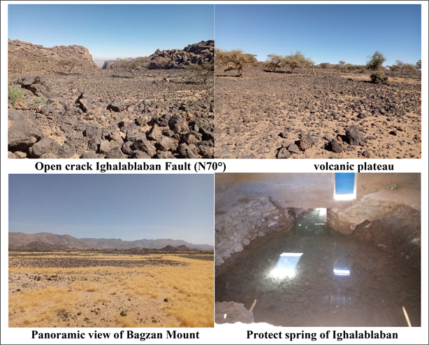
Photo 1. Ighalablaban fault and springs of water supply (Bagzan mount), 2021/01/23.
springs are carried by this major accident, which is observed almost throughout the area of Bagzan mount (Photo 1).
3.1.4. Synthesis of the Structural Mapping
The synthesis of the results from the Digital Model Elevation (DEM) and the geological map (Table 1 and Table 2) indicates the predominance of the directions N70˚-N80˚, N60˚-N70˚, N50˚-N60˚, N90˚-N100˚. The secondary orientations are: N0˚-10˚and N80˚-N90˚ in Bagzan mount area.
With regard to the percentage of cumulative fracture lengths (Table 1 and Table 2), it is clear that the mega fractures are in the directions N70˚-N80˚, N60˚-N70˚, N80˚-N90˚, and to a lesser extent in the directions N50˚-N60˚ and N90˚-N100.
The structures identified on the DEM and on the geological map are superimposed only on mega fractures. In the case of secondary fractures, these do not clearly overlap, as the DEM promotes mapping of minor structures [40] [41] [42] .
3.1.5. Fracturing Relationship and Springs
Groundwater flows back through major geological accidents mainly directions N70˚-N80˚, N60˚-N70˚ and N80˚-N90˚ to give rise to permanent springs buried in Bagzan mount (Figure 5). The springs appear on the major tectonic accidents (NE-SW) of regional importance. Thus, the identified lineaments seem to be representative of fracturing in the Bagzan area, and can guide in the future in the research of aquifers to geophysics work in Bagzan mount whose main activity and irrigated agriculture.
3.2. Discussion
In fracturing mapping, the use of DEM has demonstrated the importance of this digital tool to structural mapping. Many works [6] [7] [14] [36] [40] showed the contribution of the use of satellite images in the identification of fractured aquifers in basement area and are significantly improve the knowledge of these aquifers.
In Bagzan mount, the fracturing (Figure 6) map shows three main directions:
![]()
Figure 5. Relationship lineaments and springs (groundwater).
![]()
Figure 6. Fracturing map of Bagzan mount.
N70˚-N80˚, N60˚-N70˚ and N50˚-N60˚, and two secondary directions N90˚-N100˚ and N120˚-N140˚.
Accidents of the N70˚-N80˚ family are generally observed and the most important and remarkable in the Bagzan mount. This family of accidents has high percentage of cumulative length and formed a mega fractures.
In addition, most of the springs in the study area are on these mega-fractures or in the majority of valleys have these directions (N70˚-N80˚, N90˚-N100˚) [7] [17] [18] . It is also noted that volcanism is located on these directions NE-SW [27] and lava flows follow the valleys [43] [44] .
The N60˚-N70˚ directions are sometimes those carried by rhyolitic dykes and gabbro [45] and promote the circulation of groundwater or surface water. This direction is the second largest direction that has found Bagzan mount [46] . Moreover, in Tefidet trough North-South (NS) of Bagzan, N60˚-N70˚ accident is associated with dykes [47] .
These orientations N50˚-N60˚ have been found in the granite and dykes using satellite images in Arokam Teneré [48] which is an appendix of Aïr massif. These structures are also found in the northeast of Bagzan mount specified in the complex of Tilichenéne where some basaltic points show fractures bearing this orientation [49] and were noted in the mounts of Tamgak and Taghmert. This orientation is known in the Pan-African basement and would be linked to the pan-African episode.
The family of fractures N90˚-N100˚ is highlighted in the formations of the southern Maradi basement [50] but also in the base of the Damagaram-Mounio [51] basement and would be late to pan-African post [50] .
This direction fractures N120˚-N140˚ is well known in the center of the Aïr and in the area of Timia [7] . Directions N120˚-150˚ caused the opening of the Tefidet trough (N135˚) with significant volcanic emissions along major accidents [34] [52] . The last major phase of compression would have occurred around 0.3 million years ago [53] and would be at the base of the carbo-gaseous springs that continue to function today [18] [54] .
4. Conclusions
The major structures and lineaments highlighted on the DEM seem to be accidents that affected the Precambrian basement of Bagzan mount. This method validated by the measures of the directions of the structures, geological data and the inventory of the springs in the field allows the validation of this spatial approach. And therefore, this approach shows this performance in groundwater research in bedrock areas such as Bagzan mount. The main structures highlighted are oriented mainly: N70˚-N80˚, N60˚-N70˚, N50˚-N60˚, and two secondary directions N90˚-N100˚ and N120˚-N140˚.
These linear structures are potential indicators of groundwater accumulation and are, therefore, an important scientific tool for understanding aquifer horizons. However, these structures, when combined with other hydrogeological ports, will contribute significantly to the identification of areas favorable to the establishment of water points in Bagzan mount. Complementary geophysical studies will confirm the conductive structures and estimate the thickness of the alteration.
Thus, in this complex hydrogeological context like that of Bagzan, only spatial investigations (DEM, Satellite images) and hydrogeological allow the detection of sufficient resources for the water supply of the population and irrigated agriculture in this basement area.
However, these structures combined with other complementary hydrogeological information will significantly identify areas favorable to the location of hydraulic works. Geophysical studies will confirm these evidenced structures.
Acknowledgements
In this present work, I pay due tribute to Professor Boureima Ousmane, Dean of Hydrogeologists of Niger. Rest in peace, Dear Professor.