
Hydrogeological Hazards in Open Pit Coal Mines–Investigating Triggering Mechanisms by Validating the European Ground Motion Service Product with Ground Truth Data


Abstract
:1. Introduction
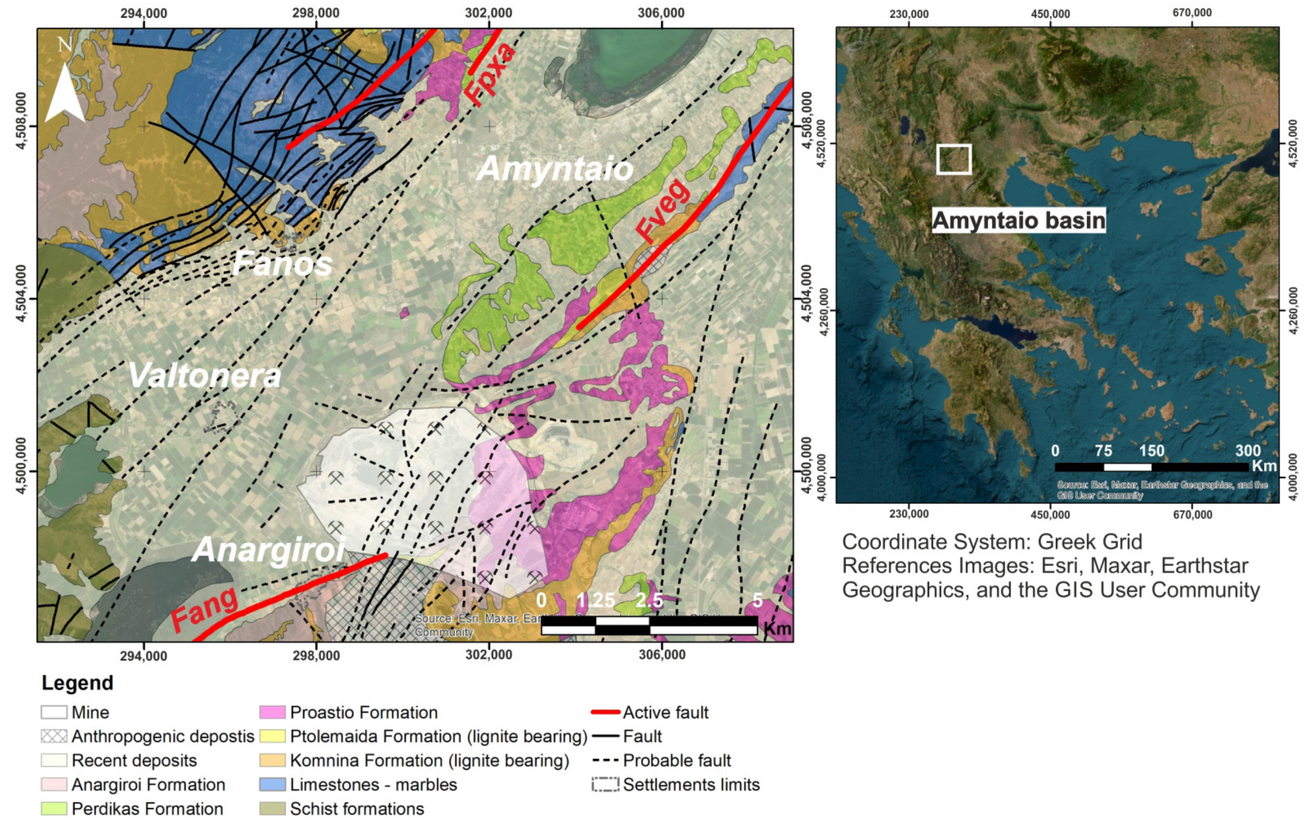
2. Study Area
2.1. Geologic, and Geotechnical Setting
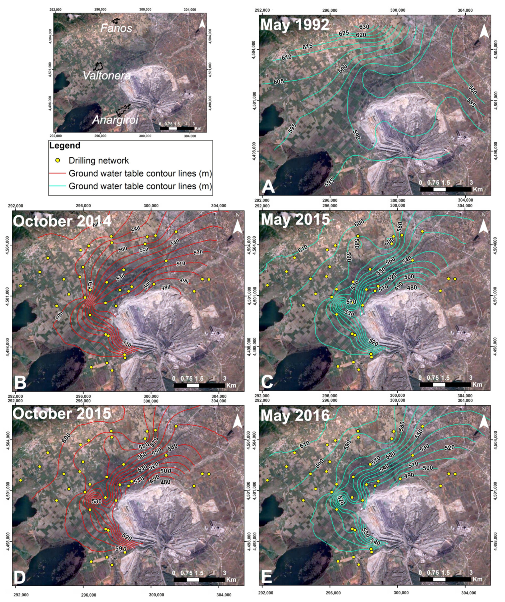
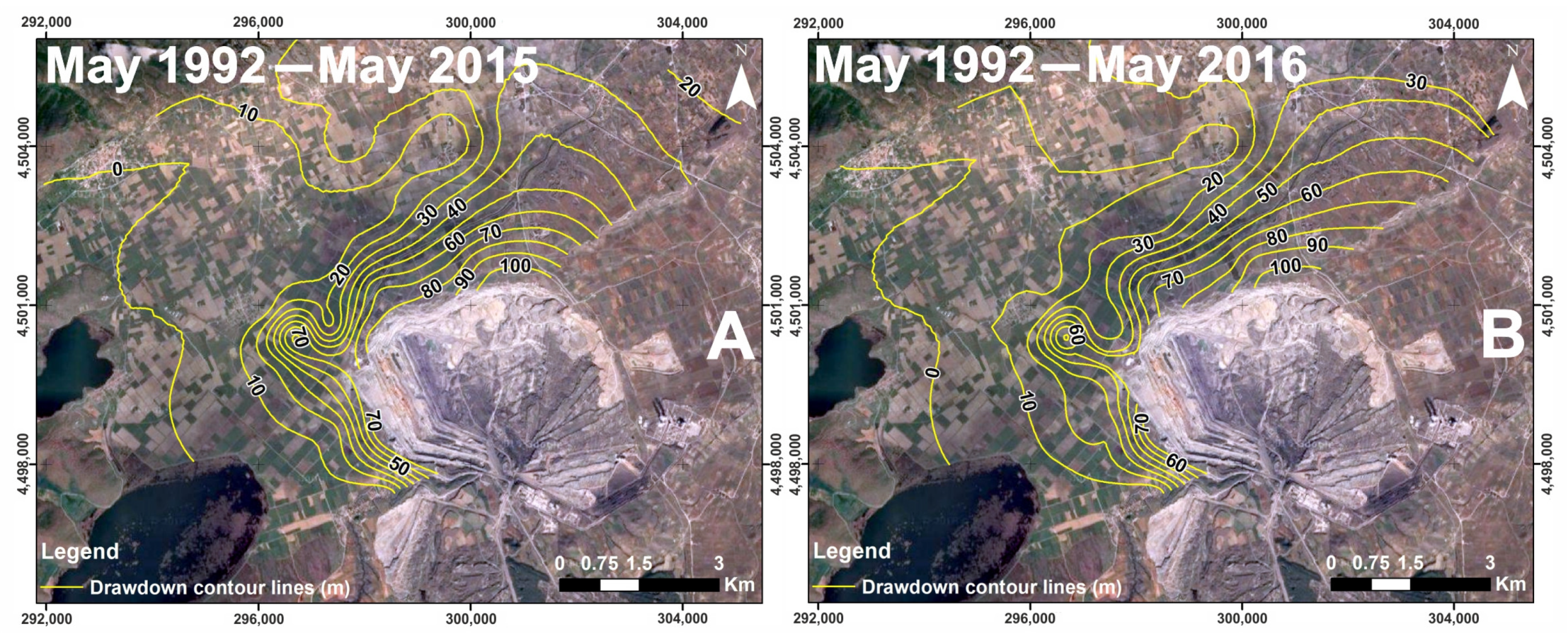
2.2. Hydrogeologic Setting

3. Methodology for the Determination of the Catastrophic Events Driving Mechanism
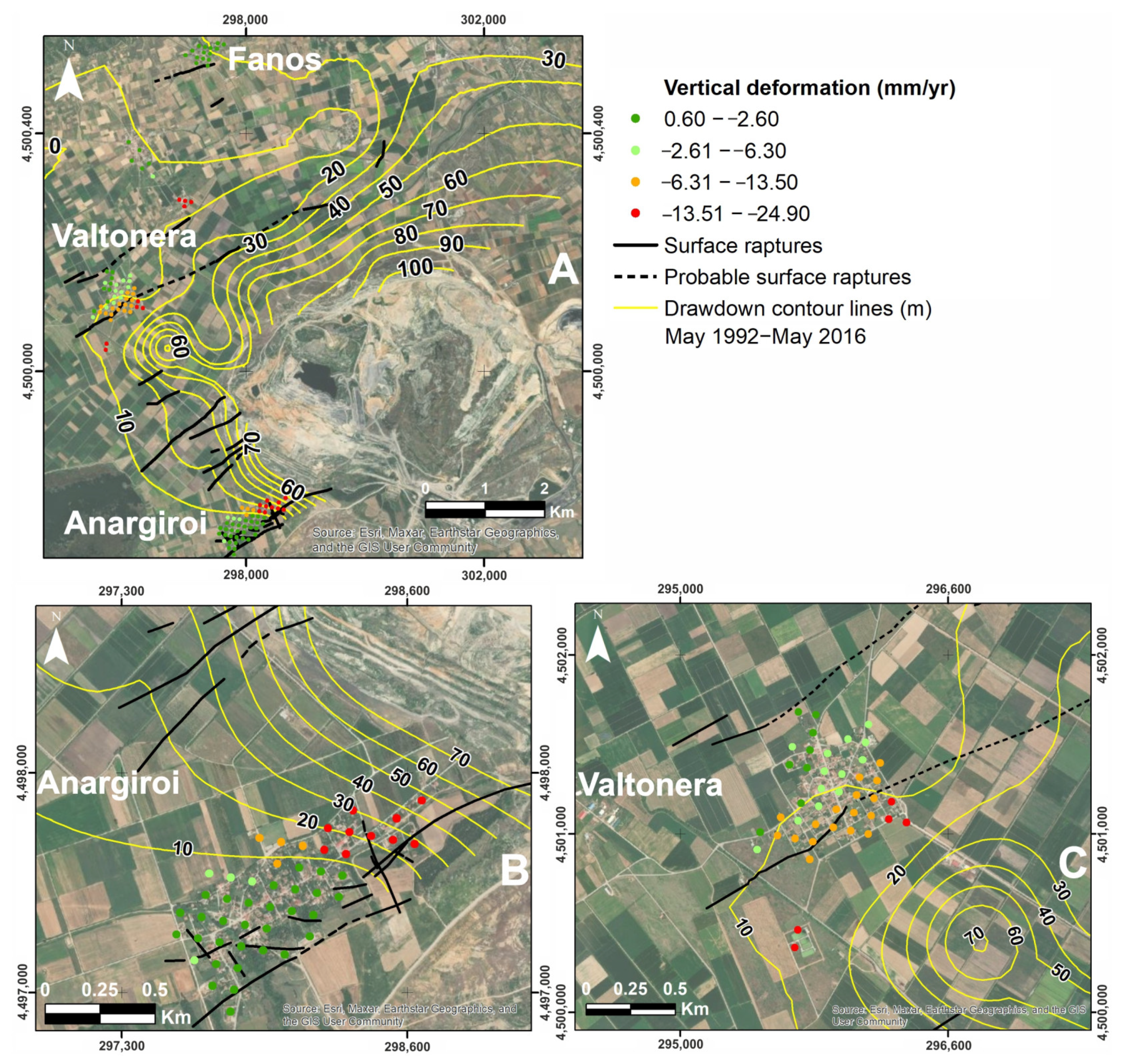
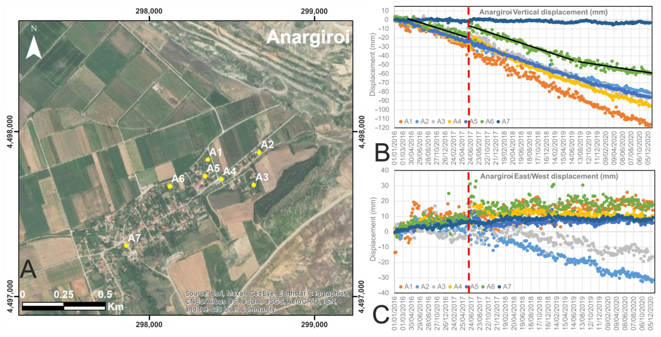
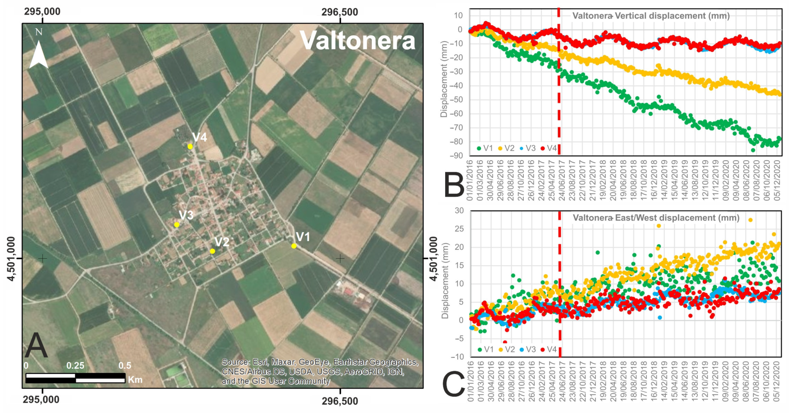
3.1. The Land Subsidence Mechanism
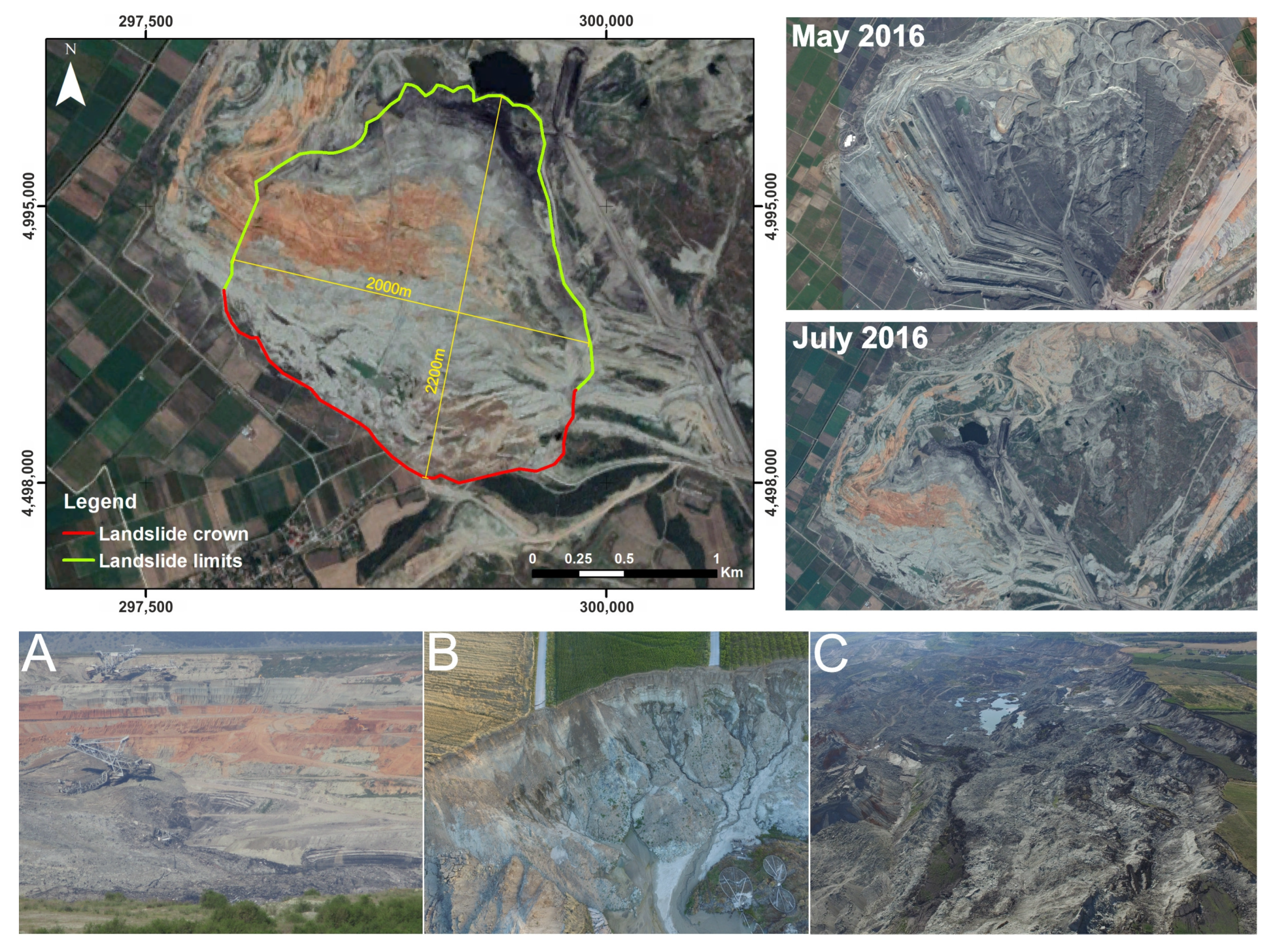
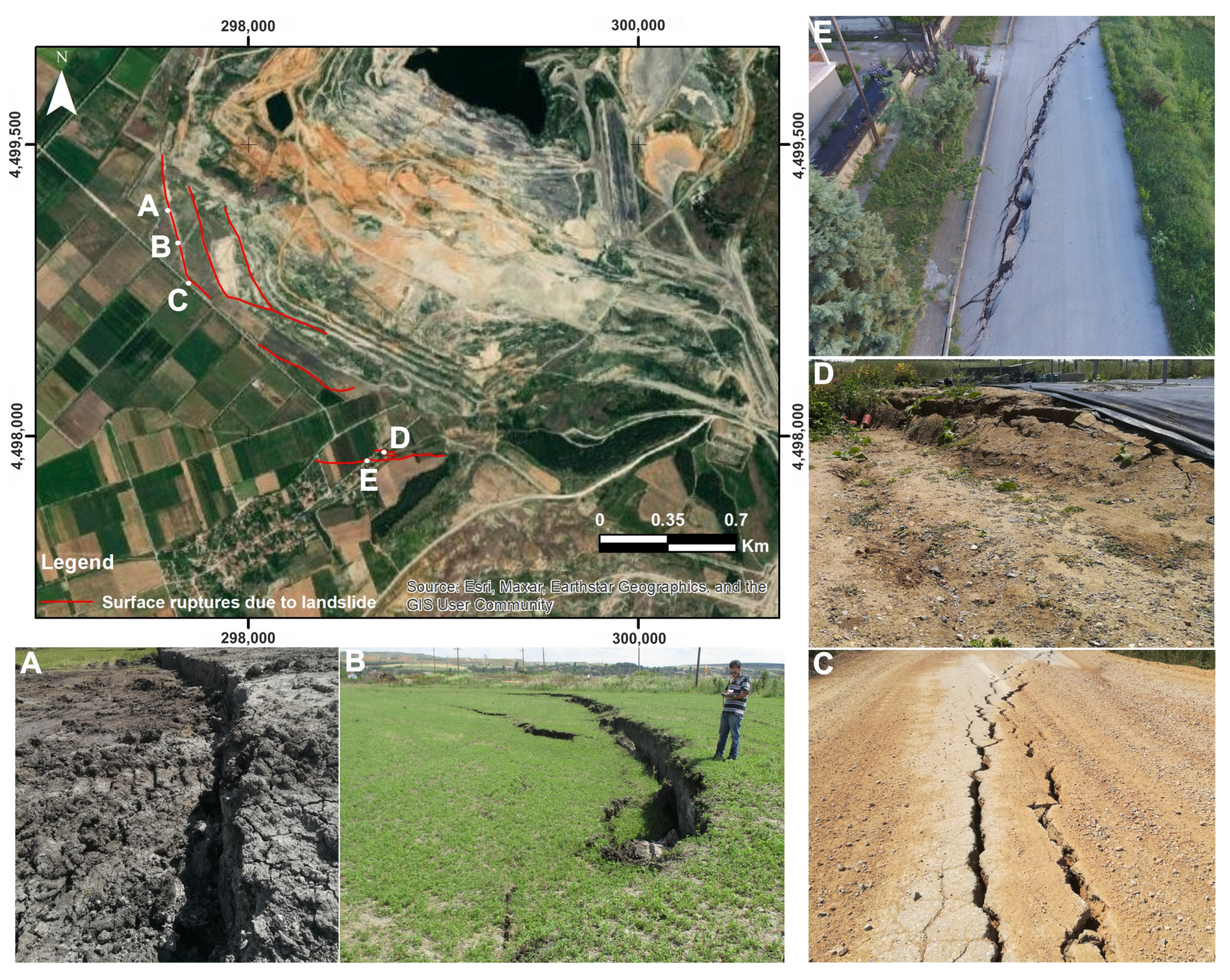
3.2. The Landslide Mechanism
4. Results and Discussion
5. Conclusions
Supplementary Materials
Author Contributions
Funding
Data Availability Statement
Acknowledgments
Conflicts of Interest
References
- Passariello, B.; Giuliano, V.; Quaresima, S.; Barbaro, M.; Caroli, S.; Forte, G.; Carelli, G.; Iavicoli, I. Evaluation of the environmental contamination at an abandoned mining site. Microchem. J. 2002, 73, 245–250. [Google Scholar] [CrossRef]
- WISE_Uranium_Project. Chronology of Major Tailings Dam Failures. Available online: https://www.wise-uranium.org/mdaf.html (accessed on 30 August 2022).
- Williams, C.; Ross, B.; Zebker, M.; Leighton, J.; Gaida, M.; Morkeh, J.; Robotham, M. Assessment of the available historic RADARSAT-2 synthetic aperture radar data prior to the manefay slide at the bingham canyon mine using modern InSAR techniques. Rock Mech. Rock Eng. 2021, 54, 3469–3489. [Google Scholar] [CrossRef]
- Moore, J.R.; Pankow, K.L.; Ford, S.R.; Koper, K.D.; Hale, J.M.; Aaron, J.; Larsen, C.F. Dynamics of the Bingham Canyon rock avalanches (Utah, USA) resolved from topographic, seismic, and infrasound data. J. Geophys. Res. Earth Surf. 2017, 122, 615–640. [Google Scholar] [CrossRef]
- Hibert, C.; Ekström, G.; Stark, C.P. Dynamics of the Bingham Canyon Mine landslides from seismic signal analysis. Geophys. Res. Lett. 2014, 41, 4535–4541. [Google Scholar] [CrossRef]
- Pankow, K.L.; Moore, J.R.; Hale, J.M.; Koper, K.D.; Kubacki, T.; Whidden, K.M.; McCarter, M.K. Massive landslide at Utah copper mine generates wealth of geophysical data. GSA Today 2014, 24, 4–9. [Google Scholar] [CrossRef] [Green Version]
- Lin, Y.N.; Park, E.; Wang, Y.; Quek, Y.P.; Lim, J.; Alcantara, E.; Loc, H.H. The 2020 Hpakant Jade Mine Disaster, Myanmar: A multi-sensor investigation for slope failure. ISPRS J. Photogramm. Remote Sens. 2021, 177, 291–305. [Google Scholar] [CrossRef]
- Sun, Y.; Zhang, X.; Mao, W.; Xu, L. Mechanism and stability evaluation of goaf ground subsidence in the third mining area in Gong Changling District, China. Arab. J. Geosci. 2015, 8, 639–646. [Google Scholar] [CrossRef]
- Carnec, C.; Delacourt, C. Three years of mining subsidence monitored by SAR interferometry, near Gardanne, France. J. Appl. Geophys. 2000, 43, 43–54. [Google Scholar] [CrossRef]
- Wolkersdorfer, C.; Thiem, G. Ground water withdrawal and land subsidence in northeastern Saxony (Germany). Mine Water Environ. 1999, 18, 81–92. [Google Scholar] [CrossRef]
- Tang, W.; Motagh, M.; Zhan, W. Monitoring active open-pit mine stability in the Rhenish coalfields of Germany using a coherence-based SBAS method. Int. J. Appl. Earth Obs. Geoinf. 2020, 93, 102217. [Google Scholar] [CrossRef]
- Mohammady, M.; Pourghasemi, H.R.; Amiri, M. Assessment of land subsidence susceptibility in Semnan plain (Iran): A comparison of support vector machine and weights of evidence data mining algorithms. Nat. Hazards 2019, 99, 951–971. [Google Scholar] [CrossRef]
- Hong, H.; Tsangaratos, P.; Ilia, I.; Loupasakis, C.; Wang, Y. Introducing a novel multi-layer perceptron network based on stochastic gradient descent optimized by a meta-heuristic algorithm for landslide susceptibility mapping. Sci. Total Environ. 2020, 742, 140549. [Google Scholar] [CrossRef]
- Kaitantzian, A.; Loupasakis, C.; Tzampoglou, P.; Parcharidis, I. Ground Subsidence Triggered by the Overexploitation of Aquifers Affecting Urban Sites: The Case of Athens Coastal Zone along Faliro Bay (Greece). Geofluids 2020, 2020, 8896907. [Google Scholar] [CrossRef]
- Svigkas, N.; Loupasakis, C.; Papoutsis, I.; Kontoes, C.; Alatza, S.; Tzampoglou, P.; Tolomei, C.; Spachos, T. InSAR Campaign Reveals Ongoing Displacement Trends at High Impact Sites of Thessaloniki and Chalkidiki, Greece. Remote Sens. 2020, 12, 2396. [Google Scholar] [CrossRef]
- Nhu, V.-H.; Thi Ngo, P.-T.; Pham, T.D.; Dou, J.; Song, X.; Hoang, N.-D.; Tran, D.A.; Cao, D.P.; Aydilek, İ.B.; Amiri, M. A new hybrid firefly–PSO optimized random subspace tree intelligence for torrential rainfall-induced flash flood susceptible mapping. Remote Sens. 2020, 12, 2688. [Google Scholar] [CrossRef]
- Ilia, I.; Tsangaratos, P.; Tzampoglou, P.; Chen, W.; Hong, H. Flash flood susceptibility mapping using stacking ensemble machine learning models. Geocarto Int. 2022, 37, 1–27. [Google Scholar] [CrossRef]
- Tzampoglou, P.; Loukidis, D.; Koulermou, N. Seasonal Ground Movement Due to Swelling/Shrinkage of Nicosia Marl. Remote Sens. 2022, 14, 1440. [Google Scholar] [CrossRef]
- Loupasakis, C. Study of the Geotechnical Conditions of the Amintaio Coalmine Slopes Close to the Anargiri Village, Aetos Municipality, Florina Prefecture, Greece; IGME: Athens, Greece, 2006; p. 48. [Google Scholar]
- Tzampoglou, P.; Loupasakis, C. Updated ground water piezometry data of the Amyntaio sub-basin and their effect to the manifestation of the land subsidence phenomena. In Proceedings of the 11th International Hydorgeological Congress of Greece, Athens, Greece, 4–6 October 2017. [Google Scholar]
- Loupasakis, C.; Angelitsa, V.; Rozos, D.; Spanou, N. Mining geohazards—Land subsidence caused by the dewatering of opencast coal mines: The case study of the Amyntaio coal mine, Florina, Greece. Nat. Hazards 2014, 70, 675–691. [Google Scholar] [CrossRef]
- Tzampoglou, P.; Loupasakis, C. Mining geohazards susceptibility and risk mapping: The case of the Amyntaio open-pit coal mine, West Macedonia, Greece. Environ. Earth Sci. 2017, 76, 542. [Google Scholar] [CrossRef]
- Tzampoglou, P.; Loupasakis, C. Evaluating geological and geotechnical data for the study of land subsidence phenomena at the perimeter of the Amyntaio coalmine, Greece. Int. J. Min. Sci. Technol. 2018, 28, 601–612. [Google Scholar] [CrossRef]
- Loupasakis, C. Contradictive mining–Induced geocatastrophic events at open pit coal mines: The case of Amintaio coal mine, West Macedonia, Greece. Arab. J. Geosci. 2020, 13, 1–12. [Google Scholar] [CrossRef]
- European Ground Motion Service. End-to-end Implementation and Operation of the European Ground Motion Service (EGMS). In Product User Manual; European Environment Agency (EEA): Copenhagen, Denmark, 2022. [Google Scholar]
- European Union; European Environment Agency (EEA). Copernicus Land Monitoring Service. 2022. Available online: https://egms.land.copernicus.eu/ (accessed on 21 September 2022).
- Crosetto, M.; Solari, L.; Mróz, M.; Balasis-Levinsen, J.; Casagli, N.; Frei, M.; Oyen, A.; Moldestad, D.A.; Bateson, L.; Guerrieri, L. The evolution of wide-area DInSAR: From regional and national services to the European Ground Motion Service. Remote Sens. 2020, 12, 2043. [Google Scholar] [CrossRef]
- Crosetto, M.; Solari, L.; Balasis-Levinsen, J.; Bateson, L.; Casagli, N.; Frei, M.; Oyen, A.; Moldestad, D.; Mróz, M. Deformation monitoring at european scale: The copernicus ground motion service. Int. Arch. Photogramm. Remote Sens. Spat. Inf. Sci. 2021, XLIII-B3-2, 141–146. [Google Scholar] [CrossRef]
- Costantini, M.; Minati, F.; Trillo, F.; Ferretti, A.; Novali, F.; Passera, E.; Dehls, J.; Larsen, Y.; Marinkovic, P.; Eineder, M. European Ground Motion Service (EGMS). In Proceedings of the 2021 IEEE International Geoscience and Remote Sensing Symposium IGARSS, Brussels, Belgium, 11–16 July 2021; pp. 3293–3296. [Google Scholar]
- Doukissa, K. Geotechnical Study of the Bridge in the Central Trench of Aanargiroi Area; Municipality of Aetos: Thessaloniki, Greece, 2010; p. 24. [Google Scholar]
- Dhmaras, K.; Georgiadhs, M. Lifting and Waterproofing Study of the Existing Embankment of Lake Cheimaditida Florina; Geognosi Public Limited Company: Thessaloniki, Greece, 2002. [Google Scholar]
- Tzampoglou, P. Mining geohazards in Greece. The case of the Amyntai open-pit coal mine. Ph.D. Thesis, National Technical University of Athens, Athens, Greece, 2017. [Google Scholar]
- Koukouzas, C.; Kotis, T.; Ploumidis, M.; Metaxas, A. Coal Exploration of Anargiri-Amynteon Area, Mineral Deposit Research; Institution of Geology and Mineral Exploration: Athens, Greece, 1979; Volume 9. [Google Scholar]
- Institution of Geology and Mineral Exploration. Geological Map of Greece, Scale 1:50,000, Ptolemaida Sheet; Institution of Geology and Mineral Exploration: Athens, Greece, 1997. [Google Scholar]
- Metaxas, A.; Karageorgiou, D.; Varvarousis, G.; Kotis, T.; Ploumidis, M.; Papanikolaou, G. Geological evolution-stratigraphy of Florina, Ptolemaida, Kozani and Saradaporo graben. Bull. Geol. Soc. Greece 2007, 40, 161–172. [Google Scholar] [CrossRef]
- Leonardos, M.; Terezopoulos, N. Rim slope failure mechanism in the Greek deep lignite mines–A case study. Min. Technol. 2003, 112, 197–204. [Google Scholar] [CrossRef]
- Mountrakis, D. Geology of Greece; University Studio Press: Thessaloniki, Greece, 1985. [Google Scholar]
- Spyropoulos, N. The geological structure of Pelagonian zone in the Mount of Askio D. Macedonia. Ph.D. Thesis, Aristotle University of Thessaloniki, Thessaloniki, Greece, 1992. [Google Scholar]
- Pavlides, S.; Mountrakis, D. Neotectonics of the Florina-Vegoritis-Ptolemais Neogene Basin (NW Greece): An example of extensional tectonics of the greater Aegean area. Ann. Géol. Pays Hell. 1985, 33, 311–327. [Google Scholar]
- Pavlides, S. Neotectonic evolution of the Florina-Vegoritis-Ptolemais basin (W. Macedonia, Greece). Ph.D. Thesis, Aristotle University of Thessaloniki, Thessaloniki, Greece, 1985. [Google Scholar]
- Pavlides, S.; Mountrakis, D. Extensional tectonics of northwestern Macedonia, Greece, since the late Miocene. J. Struct. Geol. 1987, 9, 385–392. [Google Scholar] [CrossRef]
- Koukouzas, C.; Kotis, T.; Ploumidis, M.; Metaxas, A.; Dimitriou, D. Coal Exploration of Komninon-Ptolemaidas Area. Mineral Deposit Research; Institution of Geology and Mineral Exploration: Athens, Greece, 1983; Volume 2. [Google Scholar]
- Ganas, A.; Oikonomou, I.; Tsimi, A. NOAfaults: A digital database for active faults in Greece. Bull. Geol. Soc. Greece 2015, 47, 518–530. [Google Scholar] [CrossRef] [Green Version]
- Stamos, A.; Giannoulopoulos, P. Hydrogeological Report, Geotechnical Work to the Anargiri Village, Aetos Municipality, Florina Prefecture, Greece; Institution of Geology and Mineral Exploration: Athens, Greece, 2010; p. 34. [Google Scholar]
- Tzampoglou, P.; Loupasakis, C. New data regarding the ground water level changes at the Amyntaio basin-Florina Prefecture, Greece. Bull. Geol. Soc. Greece 2016, 50, 1006–1015. [Google Scholar] [CrossRef] [Green Version]
- Tzampoglou, P.; Loupasakis, C. Land subsidence due to the overexploitation of the aquifer at the Valtonera village. Bull. Geol. Soc. Greece 2017, 50, 1006. [Google Scholar] [CrossRef] [Green Version]
- Tzampoglou, P.; Loupasakis, C. Numerical simulation of the factors causing land subsidence due to overexploitation of the aquifer in the Amyntaio open coal mine, Greece. HydroResearch 2019, 1, 8–24. [Google Scholar] [CrossRef]
- Dimitrakopoulos, D. Hydrogeological conditioning at the Amyndeon mine. Problems occuring during the exploitation and their mitigation actions. Ph.D. Thesis, NTUA, Athens, Greece, 2001. [Google Scholar]
- Tsourlos, P. Research for the Appearance of Surface Cracks in the Valtonera Village, Amyntaio Μunicipality, Florina Region; School of Geology of the Aristotle University of Thessaloniki Aristotelian University of Thessaloniki: Thessaloniki, Greece, 2015; p. 17. [Google Scholar]
- Soulios, G.; Tsapanos, T.; Voudouris, K.; Kaklis, T.; Mattas, C.; Sotiriadis, M. Ruptures on surface and buildings due to land subsidence in Anargyri village (Florina Prefecture, Macedonia). Environ. Earth Sci. 2011, 5, 505–512. [Google Scholar]
- Dimitrakopoulos, D.; Koumantakis, I. Hydrodynamic regime of Amynteon basin. Influence of open lignite mines. In Proceedings of the 11th International Hydrogeological Congress of Greece, Athens, Greece, 4–6 October 2017; pp. 101–112. [Google Scholar]
- Tzampoglou, P.; Loupasakis, C. Land subsidence susceptibility and hazard mapping: The case of Amyntaio Basin, Greece. In Proceedings of the Fifth International Conference on Remote Sensing and Geoinformation of the Environment (RSCy2017), Paphos, Cyprus, 20–23 March 2017; p. 104441L. [Google Scholar]
- NOA. Earthquake Database Search. Available online: https://www.gein.noa.gr/en/services-products/database-search/ (accessed on 25 September 2022).


Disclaimer/Publisher’s Note: The statements, opinions and data contained in all publications are solely those of the individual author(s) and contributor(s) and not of MDPI and/or the editor(s). MDPI and/or the editor(s) disclaim responsibility for any injury to people or property resulting from any ideas, methods, instructions or products referred to in the content. |
© 2023 by the authors. Licensee MDPI, Basel, Switzerland. This article is an open access article distributed under the terms and conditions of the Creative Commons Attribution (CC BY) license (https://creativecommons.org/licenses/by/4.0/).
Share and Cite
Tzampoglou, P.; Loupasakis, C. Hydrogeological Hazards in Open Pit Coal Mines–Investigating Triggering Mechanisms by Validating the European Ground Motion Service Product with Ground Truth Data. Water 2023, 15, 1474. https://doi.org/10.3390/w15081474
Tzampoglou P, Loupasakis C. Hydrogeological Hazards in Open Pit Coal Mines–Investigating Triggering Mechanisms by Validating the European Ground Motion Service Product with Ground Truth Data. Water. 2023; 15(8):1474. https://doi.org/10.3390/w15081474
Chicago/Turabian StyleTzampoglou, Ploutarchos, and Constantinos Loupasakis. 2023. "Hydrogeological Hazards in Open Pit Coal Mines–Investigating Triggering Mechanisms by Validating the European Ground Motion Service Product with Ground Truth Data" Water 15, no. 8: 1474. https://doi.org/10.3390/w15081474