Variations of Water Runoff and Suspended Sediment Yield in the Kamchatsky Krai, Russia


Faculty of Geography, Laboratory of Soil Erosion and Channel Processes, Lomonosov Moscow State University, Russian Federation, Leninskie Gory, 1, Moscow 119991, Russia
Water 2018, 10(10), 1451; https://doi.org/10.3390/w10101451
Submission received: 13 September 2018
/
Revised: 24 September 2018
/
Accepted: 9 October 2018
/
Published: 15 October 2018
(This article belongs to the Section Hydrology)
Abstract
:This study investigates the spatial and temporal variability of water runoff and suspended sediment yield in rivers in the Kamchatsky Krai territory (in the Far East of the Russian Federation). It is based on data from 269 monitoring stations for the period of hydrometeorological observations (1930–2015). The representativeness and the homogeneity of data on water runoff and suspended sediment yield was examined. Regions with prescribed limits of specific water discharge (L·s−1·km−2) and suspended sediment concentration (mg·L−1) variability were selected in the Kamchatsky Krai territory. Most rivers in this region are characterized by two relatively long trends in these characteristics that increased from the late 1970s to the early 1980s, followed by a subsequent decline (until 2015). Kamchatsky Krai includes 9 specific water discharge and 18 suspended sediment concentration regions. Hydrometeorological data of three zonal types of water runoff and corresponding suspended sediment concentration distribution were described, and five azonal types of water regime were characterized. One of these types was characterized by a nearly uniform distribution of water runoff within the year, due to the predominance of groundwater feeding source, while the rest of them had mixed feeding. The present study is the first study to describe the water regime of rivers on volcanic flanks in the Kamchatsky Krai.
1. Introduction
Variability of natural conditions and the presence of very little anthropogenic impacts on river basins in the Kamchatsky Krai create preconditions for a great variety of river runoff characteristics, including spatial and temporal variability of water runoff and suspended sediment yields. The main factors that affect their variation are underlying surface (relief, lithology, soil and vegetation) and climatic conditions (amount and intensity of precipitation) [1]. For long timescales, the temporal variability of water runoff and suspended sediment yields mainly depends on climatic conditions. Volcanic activity particularly affects water runoff and suspended sediment yield variability in the Kamchatsy Krai territory. Active volcanoes are prevalent—there are 42 in Kamchatka [2]—and the radius of ash trails during their strongest eruptions can exceed 2000 km [3], which causes a large amount of friable volcanic deposits [4,5] (up to several tens of thousands of tons per km2) to enter the surface of river basins during eruptions. After the eruptions, the flanks of volcanoes can affect surface flow. Also, wind transports the finest particles, and landslides and taluses on volcano flanks can ultimately affect river valleys. Eruptions during the winter and spring months—when snow supplies reach their maximum amounts—can lead to intensive melting and flash floods. Sometimes, volcanic eruptions can lead to the destruction of glaciers, and rivers with ice feeding lose one of the feeding sources, and as a result, the diminution of water runoff occurs. All of these conditions affect the variability of water runoff and suspended sediment yields in the rivers of the Kamchatsky Krai.
Kamchatsky Krai is the primary spawning territory for salmon species such as king salmon, silver salmon, red salmon, chum salmon, and hunchback salmon, and it is also the most productive area in terms of fishing in the Russian Federation [6]. The salmon populations are strongly affected by water runoff and suspended sediment concentration fluctuations [7,8]. Therefore, the current study is especially important for fishery. Collecting and analyzing recent hydrometeorological data allows us to better understand the spatial and temporal distribution of water runoff and suspended sediment yields in the territory.
Current climate changes [9] significantly impact water runoff and suspended sediment yield characteristics, and rivers in the Kamchatsky Krai in the Far East of the Russian Federation are no exception. The features of the spatio-temporal variability of water regimes and suspended sediment yield characteristics were studied in the 1970s [10,11] when four regions with similar specific water discharge and suspended sediment concentration were delineated. At the last time, the territory was divided into five regions with various types of water runoff distribution within the year and included the main feeding sources. There are only two studies based on recent hydrometeorological data associated with water runoff variability and its dependence on precipitation in the Kamchatka Peninsula [12,13]. Later generalizations on water runoff and suspended sediment yield distribution mainly describes global distribution and do not consider the Kamchatsky Krai territory in detail [14,15,16]. Inter-year fluctuations of water runoff and suspended sediment yields have yet to be studied.
Formation and variability of water runoff and suspended sediment yield characteristics in long-term spatial and temporal scale occur under the influence of topography (elevation, relief, slopes, and slope length) [17], climate (amount of precipitation, intensity and distribution, permafrost, eolian activity), lithology (bedrock), soil and vegetation (types of soils and vegetation), hydrological conditions (types of water regime influence on suspended sediment yield distribution), gravitational processes (landslides, screes, and etc.) [18,19] and tectonics (earthquakes) [20,21].
Relief influences the water regime and erosion through impact on formation and redistribution of precipitation, soils, and vegetation [22]. Water runoff and sediment yield formation depends on mean height and slopes, their length, and ruggedness number [23,24]. Climatic factors primarily impact on water runoff and sediment yield through the amount and intensity of precipitation [25,26]. Rocks permeability for water and their erosion depends on lithology. Friable rocks (sands, sandy loam, loam, clay, and detritus-gravel) have maximum erodibility; the minimum erosion characterizes rocky crystals [27,28]. Water runoff and sediment yield is also determined by characteristics of soils. Erodibility of soils depends on organic matter content, soil structure, water permeability, and particle size distribution. Vegetation influences water runoff and sediment yield through soil erosion protection due to reduction of depth of runoff and speed of rain and melted water flow [29,30]. Hydrological conditions influence suspended sediment yield (SSY) through the erosion and accumulation of sediments in the drainage network and variability of transport capacity of the stream along the rivers [31]. Water regime of rivers determines the main features of seasonal distribution of suspended sediment concentration (SSC) and suspended sediment flux (SSF).
The mass wasting processes in river valleys can significantly influence sediment. Landslides and other processes (debris flow, rock fall, slumping, creeping) are the sources of sediment in the rivers [19,32]. For some regions (for example, Southern Alps in New Zealand), the key factor of suspended sediment yield formation is landslides, which lead to short-term increases of specific suspended sediment yields up to 7000 Mg·km−2·year−1 [18]. A similar influence can be exerted by earthquakes through intensification of landsliding, variation of local and common erosion bases, transformation of river valleys leading to the increasing of erosion [33].
Volcanic activity is the unique factor of water runoff and suspended sediment yield formation and variability in Kamchatka. Volcanic eruptions are a constant source of friable volcanic material (such as ash, pyroclastic) and bad erodible andesitic, andesitic-basaltic, and basaltic lava in river basins. As the result, rivers with specific water regime are formed in volcanic regions. They are characterized by periods of no runoff and significant underflow.
Ashfalls influence soil formation [4,5] and vegetation [34,35] (volcanic flanks often have no vegetation cover). Major volcanoes in Kamchatka have maximum altitude in the peninsula, level difference and the ruggedness number reach their maximum there, due to the processes of relief reformation. Steep slopes and easy erodible rocks create preconditions for mass wasting processes.
Highly erodible volcanogenic deposits fall in the river basins during volcanic eruptions due to ashfalls, pyroclastic flows, and lahars [36]. Pyroclastic flows spread on vast territories (more than 103 km2), significantly influencing landscape evolution through filling topographic depressions, disrupting of drainage network, and causing knick-point formation and retreat [37]. Major eruptions are the sources of large quantities of sediments in rivers, and short-term increase of sediment yield can reach up to 106 m3·km−2·a−1 [38]. In many cases, the increasing of sediment yield is facilitated by absence of vegetation, a decrease of infiltration rates and increased runoff [39].
Volcanic eruptions impact the hydrological regime of rivers [40]. Within 5–10 years after the catastrophic eruption of Mount St. Helens (USA) on 18 May 1980, increasing of peak discharges was observed in autumn and winter, due to the decrease of lag-time and increase of channel efficiency [41]. In some cases, the processes of water transfer changes, when compared with the period before the eruption. In the post eruption period, loss of canopy interception, a greater amount of precipitation reaching the ground surface, reduced evapotranspiration, a reduction of surface infiltration and more prominent overland flow, were observed.
Volcanic eruptions lead to extreme increases in suspended sediment yield in rivers draining flanks of volcanoes [40,42]. Annual suspended sediment yield exceeded background level with 500 times after the catastrophic eruption of Mount St. Helens in 1980. After 20 years the average annual suspended sediment yield were 100 times greater than typical background level (~102 t·km−2) and remained 104 t·km−2 [43]. After 30 years approximately 350 million tons of suspended sediment was delivered from the Toutle River basin to the Cowlitz River (roughly 40 times greater than average annual suspended sediment yield of the Columbia River) [44]. Specific suspended sediment yield increased to 106–107 Mg·km−2·year−1 after the Pinatubo volcano eruption (Philippines) in 1991; SSC in the Pasig-Patrero River reached 9–293 kg·m−3 while the water discharge was 1.2–66 m3·s−1 [45].
The main data on water runoff and suspended sediment yields of the rivers in the Kamchatsky Krai are based on analysis of hydrological monitoring data. Processing this data allows estimation of renewable water resources and suspended sediment yields and allows us to describe the variability of water regime types. According to P.S. Kouzin’s classification [46], there are rivers with floods, floods and flash floods, and with flash floods only.
Mountainous relief with high slopes and elevations, significant amount of precipitation both during the warm and cold seasons, distribution of vegetation cover and particular soils in the Kamchatsky Krai create specific conditions for water runoff and sediment yield formation in river basins there. This study seeks to analyze the spatio-temporal variability of water runoff and suspended sediment yields of rivers in the Kamchatsky Krai and to develop a new interpretation of zonal and azonal types of the water regime of these rivers. The importance of this work is also connected with the specificity of natural conditions of water regime formation in the territory.
2. Materials and Methods
2.1. Study Region
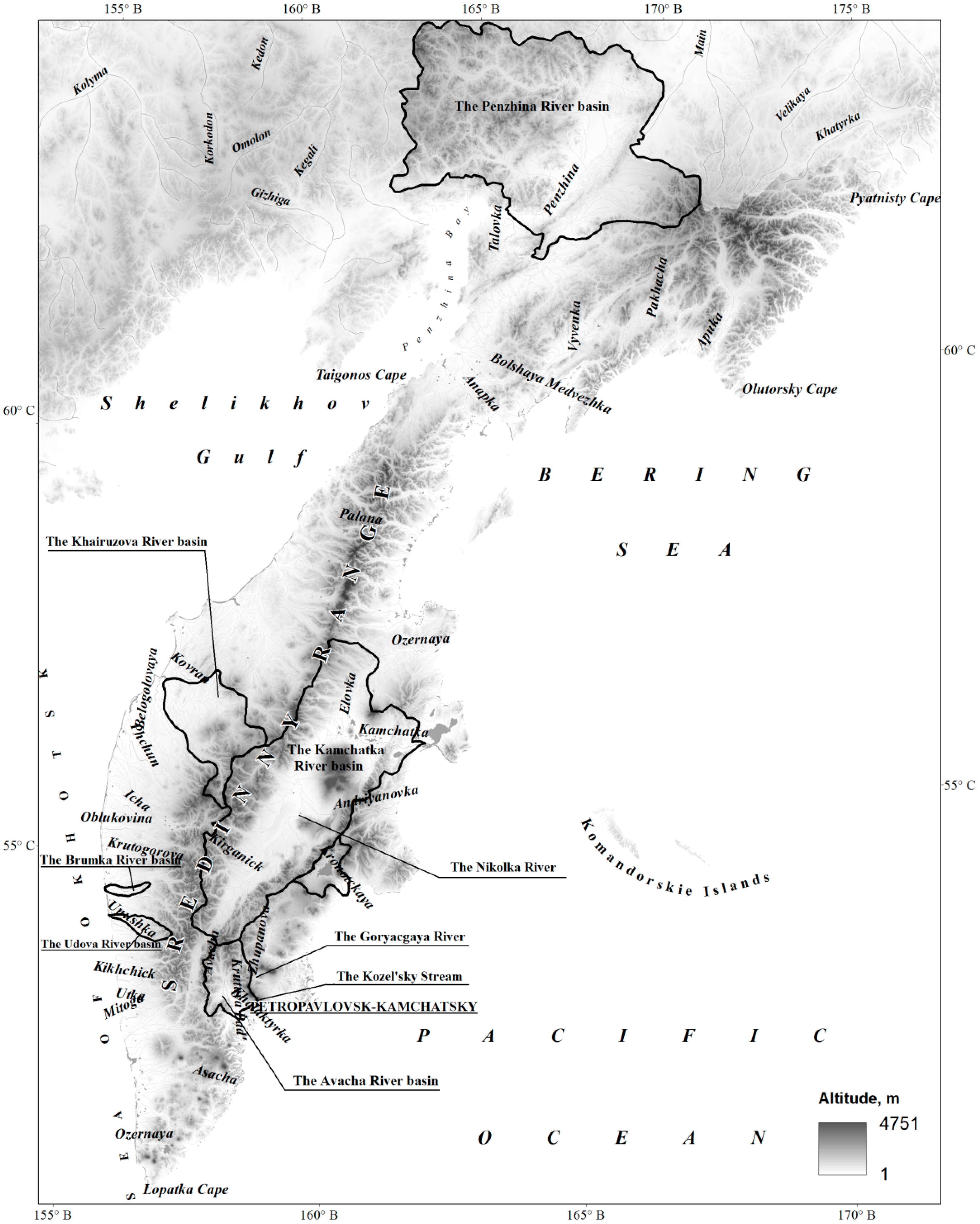
The study area of the Kamchatsky Krai is situated in the Eastern part of Russia and unites the Kamchatka Peninsula and river basins flowing into the Penzhina Bay (from the Taygonos Cape in the west to the Rekinniksky Bay in the east) and into the Bering Sea (from the Anapka River mouth in the south-west to the Pyatnisty Cape in the north-east (Figure 1). Components of the river water balance in the western and eastern parts of the peninsula mainly depend on processes of moisture transfer from adjacent water areas and orographic factors. Kamchatka is surrounded by the Sea of Okhotsk in the west and the Pacific Ocean and the Bering Sea in the east. The Sredinny Range is an orographic barrier for air masses that cause a significant difference in river runoff in the eastern and western parts of the peninsula. The northern (continental) part of the region differs significantly from the peninsula in terms of natural conditions. There is less precipitation in the northern part, and the distribution of relief is more complicated than in the peninsula. Mountain systems with well-developed vertical zonality of landscapes in the eastern part of the peninsula and in the north of the continental part influence the regularities of river runoff formation and distribution within the year. The western part of the peninsula is mainly occupied by a hilly-ridge plain and the west coastal lowland. A volcanic plateau concentrates nearly all of the active volcanoes in Kamchatka and is situated in the south-east, and there are many hot and thermal springs and geysers there [47].
There are more than 140,000 rivers in the Kamchatsky Krai with a total length of about 350,000 km. The river density is estimated to be approximately 0.94 km km−2 [47]. The densest river network characterizes the continental part of the region (its density varies from 0.8–1.0 km km−2 in the north to 1.1–1.4 km km−2 in the south) due to permafrost distribution. The river density in the peninsula varies from 0.5 to 0.7 km km−2 (till 0.9–1.0 km km−2 in the east coast of Kamchatka), while the river density decreases to 0.3 km km−2 in some river basins in the central part of the peninsula. The maximum river density is at approximately 500–700 m in the Kamchatka River basin, and it decreases in zones higher and lower of it. For the Avacha River basin, this type of region is situated between 200–500 m. Regularities of river density variability at various heights are disturbed for some river basins under the impact of volcanic activity due to complications including snowmelt and intense precipitation. Simplification of the river network is observed at lower altitudes due to filtration of water runoff into friable volcanic deposits [11].
2.2. Factors of Water Runoff and Suspended Sediment Yields Formation
The Kamchatsky Krai is characterized by a great variety of landscapes. Main land forms are stretched from northeast to southwest. Mountain ranges and plateaus cover 65% of the Kamchatsky Krai. Intensity of water runoff and suspended sediment yield formation depends on slopes. They range from 120 to 400% in the mountains, while in plain areas it varies from 25 to 100%. Plain territories cover 35% of the Kamchatsky Krai [47].
Relief influences water runoff formation and erosion through formation and redistribution of precipitation, distribution of soils, vegetation, and land use. The relief influence is characterized by relief erosive index [1] considering mean height and slopes, slope length, ruggedness number. Relief erosive index varies from 1.6 and 2.3 in Parapol dale and Penzhina lowland to 837 in the Vostochny volcanic region [47].
Geology is the main factor controlling the groundwater source [48] of feeding which is the primary one for all zonal hydrological regimes in the Kamchatsky Krai due to permeable, soluble and highly fractured underlain bedrock [49].
Water runoff and erosive processes in the territory depend on climatic factors such as amount and intensity of precipitation, rainfall and melted water distribution in surface runoff, and soil moisture. Geographical position of the Kamchatsky Krai and orography of the region determine amount and distribution of the precipitation in the territory. The most intensive cyclonic activity is in the south; it subsides significantly to the north and decreases the mean annual amount of precipitation correspondingly. There is more precipitation on windward eastern flanks of mountains, than on leeward western flanks and protected river valleys. Analysis of precipitation data demonstrates variability of mean annual values from 300 mm year−1 in the north of the region to 1310 mm year−1 in the south-east of Kamchatka.
The intensity of erosion depends on rainfall erosive factor considering the rainfall amount and intensity, impact of rain drops and rock capacity to absorb water [1]. Maximum values of rainfall erosive index are observed in Vostochny volcanic, Vostochny seaside regions and Zapadnaya Kamchatka plain. Minimum values characterize the northern part of the region [49].
A significant factor of water runoff and suspended sediment yield formation is soil–vegetation cover. There 22 districts with various vegetation in the Kamchatsky Krai [35,50]. There is vegetation of arctic tundra in the north of the Kamchatsky Krai and in the mountain regions. Flanks of mountains and mountain ranges are covered by cedar and alder elfin wood and light forest of Erman’s birch. Spruce and larch forests prevail in the Central Kamchatka plain. Sphagnum bogs are spread along the Sea of Okhotsk coast. Alder-poplar and aspen-birch forests with tangles of gigantic annual grass crops grow in flood plains and lowest above the flood plain terraces. The southern part of the Kamchatsky Krai is taiga zone while the northern one is forest-tundra. Flanks of active volcanoes almost have no any vegetation [47].
The difference in surface runoff and suspended sediment yield in forest and farmland river basins can reach an order of values. In natural conditions of the Kamchatsky Krai vegetation has no significant impact on surface runoff and suspended sediment yield because dense vegetation cover protects almost the whole area. The maximum protective feature belongs to forest vegetation (vegetation index reaches 0.003–0.007); bushes have values 0.11–0.21. Maximum values of vegetation index (0.45) (i.e., minimum protection) characterize regions covered by volcanic deposits and without any vegetation [47].
Mostly, it is volcanic soils of various subtypes that are distributed in the Kamchatsky Krai (cover approximately 40% of the territory). Podburs cover about 20%. Peats, podzolic and meadow soils cover 34% of the territory in almost equal proportion. Soils also depend on modern volcanic activity. In the territory of intensive and moderate ashfall zones [5] pyroclastic material falls at least once per 10–20 years, but in some decades the frequency increases to once per year. About several thousands of tons per 1 km2 can fall on the surface during one eruption; thickness of ash layer can reach several tens of centimeters [51].
Distribution of water depends on soil properties, influencing soil moisture, and infiltration characteristics [52]. The influence of soil type on water runoff and erosion is characterized by soil erodibility factor [1] depending on humus content, soil cover structure and permeability, content of clay and sand particles. Diversity of these characteristics influences various liability of soils to erosion and penetration of water. Soil erodibility is maximum for volcanic soils (0.14–0.80), and its minimum for podburs (0.11–0.14) [47].
The type of land use such as forest removal, urbanization, agriculture can significantly impact on water runoff and suspended sediment yield formation and distribution [53,54,55]. But in the Kamchatsky Krai territory, there is no significant human impact, and most of the river basins in the region are characterized by very low impact (less than 10% according to [56]). The level of urbanization and agriculture is very low in the region. There are only three cities (where 78% of the population is concentrated now) and several settlements. Population density is very low (in 2018 an average population density is 0.68 human per 1 km2). Agriculture is not well developed due to the climatic conditions in the area. Urbanization and agriculture can only have very local and insignificant influence. There are some mine works in the territory which have very strong but local impact on river regimes and suspended sediment yield [57]. Almost one-fifth part of the Kamchatsky Krai is occupied by especially protected natural territories (according to [58]).
2.3. Monitoring Water Runoff and Suspended Sediment Yields
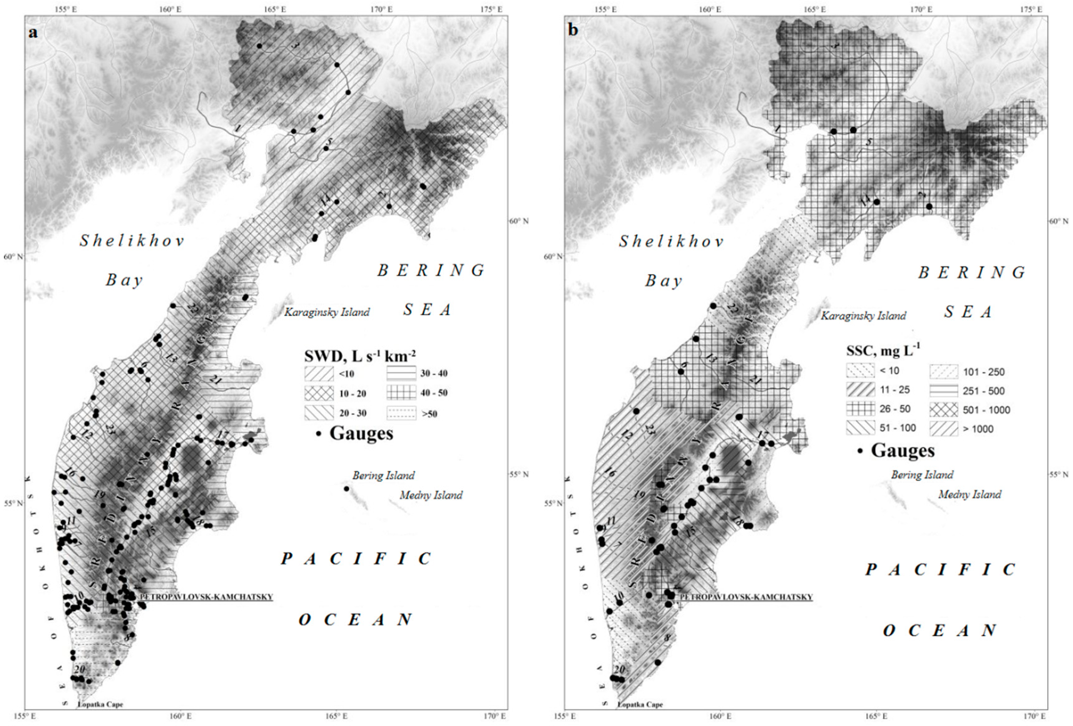
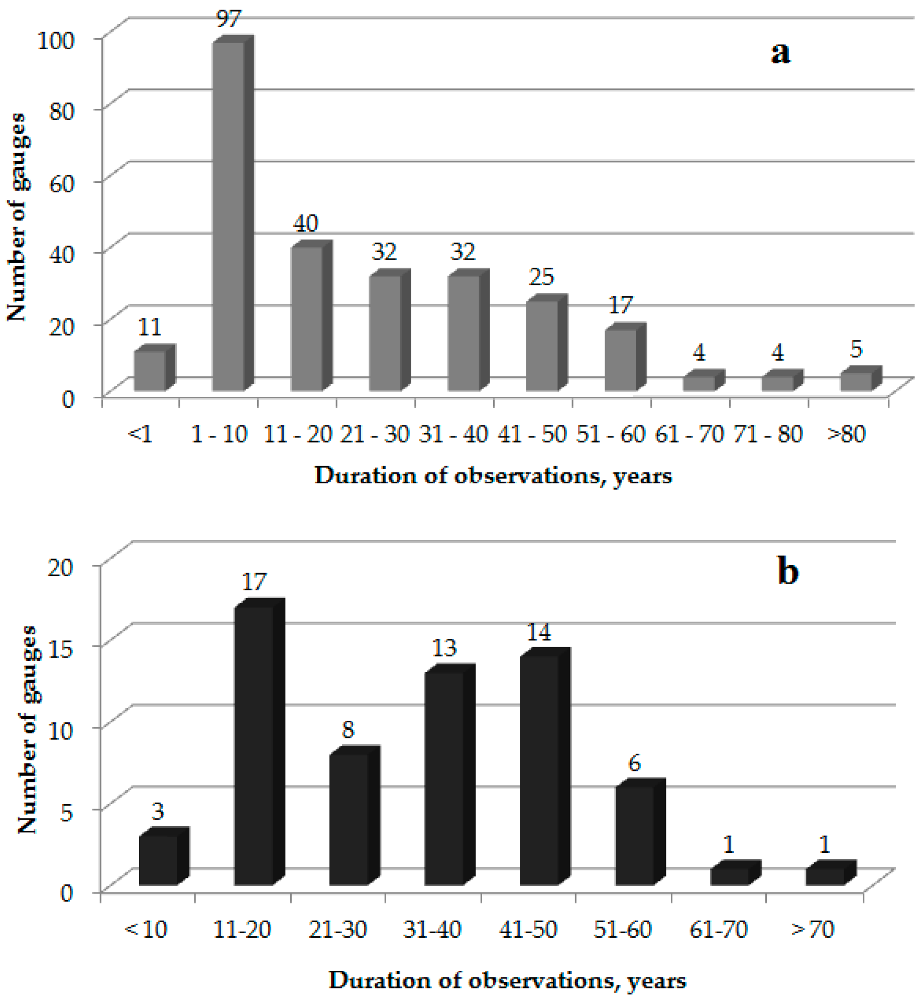
There were 269 monitoring stations that measured water runoff and levels in the territory of the Kamchatsky Krai for the period of hydrometeorological observations (since 1930 till 2015, Figure 2a). The number of operating gauges peaked in 1980 when 146 gauges were simultaneously operating. A total of 86 gauges operated in 2010. The average duration of the observations is 22 years. The period of hydrometeorological observations does not exceed 10 years for some gauges (Figure 3). The majority of the water runoff gauges are situated in river basins with areas less than 2000 km2 (76% of all gauges). The gauges are distributed very unevenly. There are a relatively large numbers of gauges in the large plain rivers (the Avacha River, the Kamchatka River) that flow into the Pacific Ocean. There 28 operating gauges in the Kamchatka River basins (1 gauge per 2000 km2 in average) and 12 gauges in the Avacha River basin nowadays (1 gauge per 420 km2). There is only one gauge (in the Palana River; three gauges are closed) north of the peninsula. There are only 8 operating gauges in the continental part of the Kamchatsky Krai now (6 of them are situated in the Penzhina River basin; 10 gauges are closed).
Regular monitoring of suspended sediment yield characteristics in rivers of the Kamchatsky Krai started in 1940. Observations were organized in the Kamchatka River (gauge Kliuchi) and the Avacha River (gauge Elizovo). A total of 16 gauges operated from 1960, 37 since 1970, and 53 since 1980. The average density of gauges was 1 gauge per 8760 km2 drainage area. The maximum density of monitoring stations was in the Kamchatka River basin, where 1 gauge covered 1530 km2 between 1940–2015. Between 1941–2015, suspended sediment yield monitoring was implemented in 69 stations. A total of 6 of them had only episodic data, and they were excluded from this study’s analysis. The duration of observations varied from 6 to 74 years for 63 selected gauges (see Figure 2b). More than half of the gauges (54%) were situated in river basins with catchment areas greater than 500 km2; hence, 46% were in river basins with areas less than 500 km2. A total of 20 stations with observations on suspended sediment yield currently operate in the territory (1 gauge per 23,000 km2 on average). The duration of observations of these gauges varies from 37 to 74 years.
Monitoring of water runoff and suspended sediment yields is implemented on stations according standard instructions on these characteristics’ measurements in dependence on river size and hydrological events on river (i.e., flood or low-water period), time scale also depends on season [59,60,61,62,63].
2.4. Methods
The representativeness [64] of all of the series of observations was evaluated, and even measurement periods as short as 6 to 10 years appear to be representative (probably the observation data hit into the water- and sediment-average period with absence of significant hydrological events). As a result, these data were used for defining water regime types and zones having similar suspended sediment yield characteristics.
The statistical characteristics for representative data were calculated by a method of moments [65]:
where Q0 is the mean annual water runoff (m3 s−1), Qi is the water runoff in i-year (m3 s−1), R0 is the mean annual suspended sediment flux (SSF, kg s−1), Ri is the suspended sediment flux in i-year (kg s−1), and n is the duration of observations in years.
The homogeneity of data on water runoff and suspended sediment yield was examined using Student’s t-test [66] and F-test [67]. These criteria demonstrate that the observations in most of the rivers in the Kamchatsky Krai are heterogeneous. Only the data ranges of maximum duration are relatively homogeneous. Generally, there is a tendency for suspended sediment yields to decrease in rivers of the Kamchatsky Krai, which coincides with changing water runoff.
3. Results
The long-term fluctuations of water runoff and sediment yield are characterized by difference–integral curves. Increasing and decreasing trends of water runoff and sediment yield are connected with climatic changes associated with precipitation variability. Most Kamchatsky Krai rivers are characterized by two relatively long trends in water runoff and SSC fluctuations. Runoff and SSC increased from the late 1970s–early 1980s and then declined thereafter. This pattern in Kamchatsky Krai rivers appears to be independent of the basin area (the characteristics were studied for river basins with area from less than 10 to more than 50,000 km2).
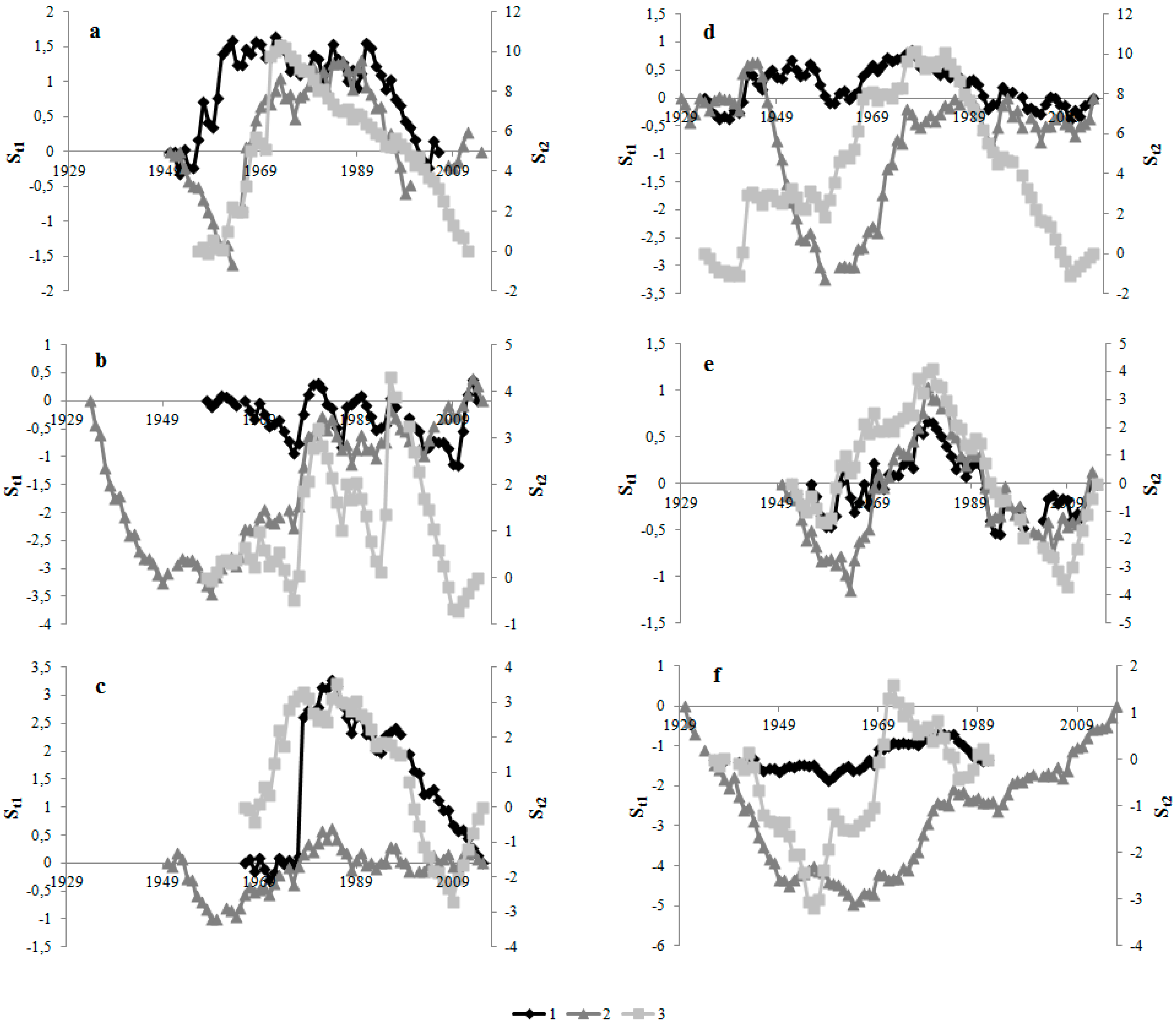
Rivers in the northern (continental) part of the region appear to be characterized by two relatively long SSC trends. There was an increase of water runoff in 1957–1969, it appeared to be close to normal in 1970–1997, and then there was a subsequent decline in 1998–2010 (Figure 4a). These trends coincide with variations of precipitation. There was an increase in runoff between 1957 and 1974 and a subsequent decline between 1975 and 2010. Rivers in the western part of the peninsula display no long-term trends; water runoff and SSC increased from 1976 to 1981, appeared close to normal between 1982 and 1996, and declined after 1997 (Figure 4b). These fluctuations are synchronous with precipitation variability. The increase of water runoff and SSC was observed in rivers of the south-western region until the end of 1970s, to the beginning of 1980s; then, a decrease of these runoff characteristics was observed (Figure 4c). In the eastern part of the peninsula, water runoff and SSC increased synchronously between 1941 and 1977 and then subsequently declined (Figure 4d). In the central part of the peninsula (the Kamchatka River Basin), two phases of water runoff and SSC fluctuations occurred; reduced runoff was observed from the mid-1950s to the 1960s, followed by a period of increased runoff (Figure 4e). The long-term trends in river runoff and SSC described previously display substantial interruptions in response to volcanic eruptions (Figure 4f). The maximum increase in specific suspended sediment yield (SSSY) was measured in the Kamchatka and the Tolbachick Rivers after the major eruptions of the Bezymyanny (1956), Shiveluch (1964), and Plosky Tolbachick (1974–1975) volcanoes.
3.1. Zonal Types of Water Regime
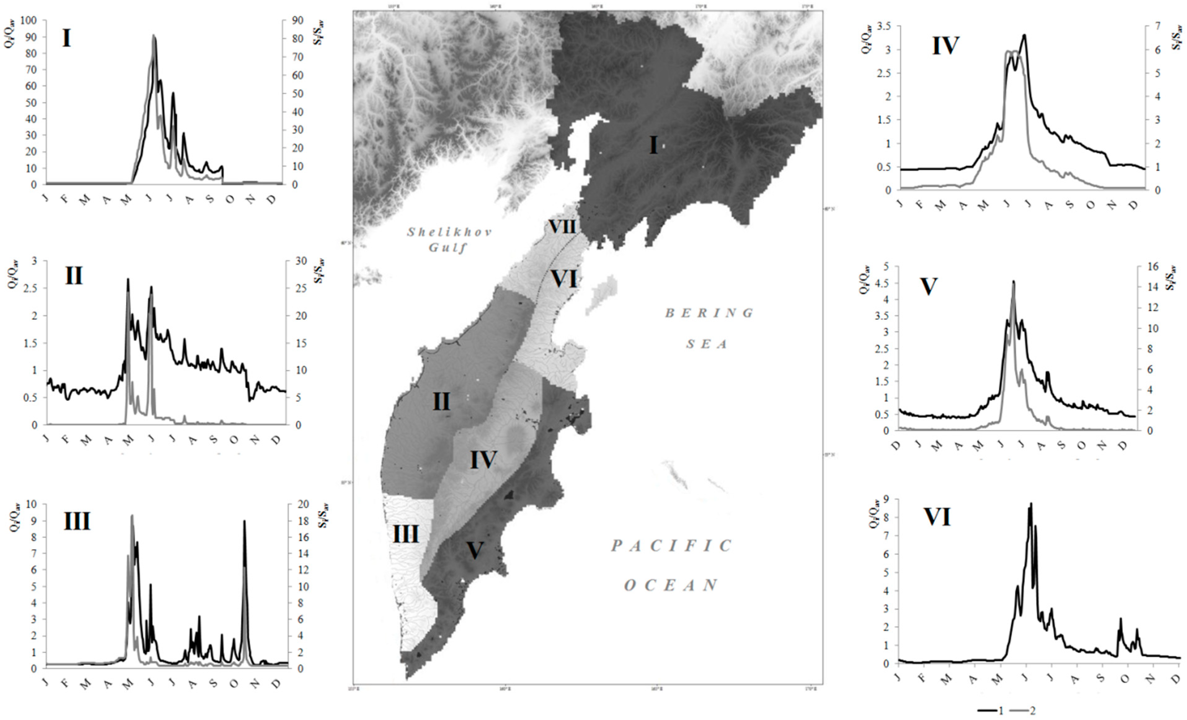
Our analysis of hydrographs demonstrated the diversity of water regimes of rivers in the Kamchatsky Krai. Rivers of the region could by divided into rivers with a spring–summer flood period, spring–summer flood and flash floods in the warm period of the year, and a spring flood period and flash floods by runoff distribution within the year. All these types of water regime described below are only found in the northern hemisphere [15].
A spring–summer flood period is observed for all rivers flowing into the Pacific Ocean, the Bering Sea (from Lopatka Cape to Sivuchy Cape), the Ozernaya River flowing into the Sea of Okhotsk, and the Bolshaya River in the upper course. The mean elevation of their basins does not exceed 200 m. During the high discharge season, these rivers transport 50–75% of the annual river runoff. The maximum discharge exceeds the minimum one by 5–16-fold. This ratio reaches a maximum in low-water years and a minimum in high-water years. The duration of heightened water runoff and low water runoff is correlated as 3:5. On the basis of graphical hydrograph analysis [70,71,72], it was established that the main runoff source is underground water. The coefficient of natural water runoff overregulation is less than the mean value for the Kamchatsky Krai territory (0.4). The maximum water runoff coincides with the maximum of SSC. The distribution of sediment flux mainly coincides with water runoff distribution. The relative variability of SSFs exceed the similar value for water discharge approximately in two times. Rivers with this type of water runoff distribution are situated in the central, eastern and south-western hydrological regions (Figure 5). This type of water regime is widely spread in Scandinavian countries and across the Russian Federation territory and is also found in the western part of Canada (New Scotland peninsula and the north-western Appalachi) [15,73,74] due to the climate features (long cold period of 5–6 months) [75].
Spring–summer floods with flash floods are observed in rivers flowing into the Sea of Okhotsk (to the north from the Ozernaya River mouth) and the Bering Sea (to the north from the Sivuchy Cape). Basins of these rivers are situated in the West Kamchatka plain and on the west slope of the Sredinny Range and also in the northern (continental) part of the region. During the flood periods, powerful floods are formed there. The ratio of maximum water discharge and minimum water discharge depends on the water content during the year and varies between 4 and 40. The coefficient of natural water runoff overregulation is less than the mean value for the Kamchatsky Krai territory. The distribution of SSF coincides with water runoff fluctuations. The relative variability of SSF is less than water discharge variation for rivers in the northern region and can exceed it by more than 10 times (rivers in the Western region). Rivers with this type of water regime are distributed in the northern, western, and south-western hydrological regions (see Figure 5). In global scale, the similar type of water regime is only found in Norway and the Russian Federation polar regions [15,73,74,75].
Rivers with spring flood and flash floods are situated in the Western Kamchatkan and Central Kamchatkan plains and in the piedmont basins in the Eastern Volcanic region. Spring floods begin in the first ten-day period in April and end in the second part of May. Rivers with this type of water regime are not spread in the territory of the Kamchatsky Krai. They are characterized by domination of underground sources. The water regime of these rivers is characterized by a maximum irregularity of water runoff and ratios between maximum and minimum water discharges (it reaches its minimum during low-water years and its maximum during high-water years). These rivers are characterized by low discharge during the low-water period. The coefficient of natural water runoff overregulation is relatively small. In some years, rivers with this type of water regime become dry and freeze through. The relative variability of SSF exceeds water discharge variation by approximately two times. Rivers with this type of water regime are distributed in the south-western, central, and eastern hydrological regions (see Figure 5). This type of water regime is not widely spread all over the world [15].
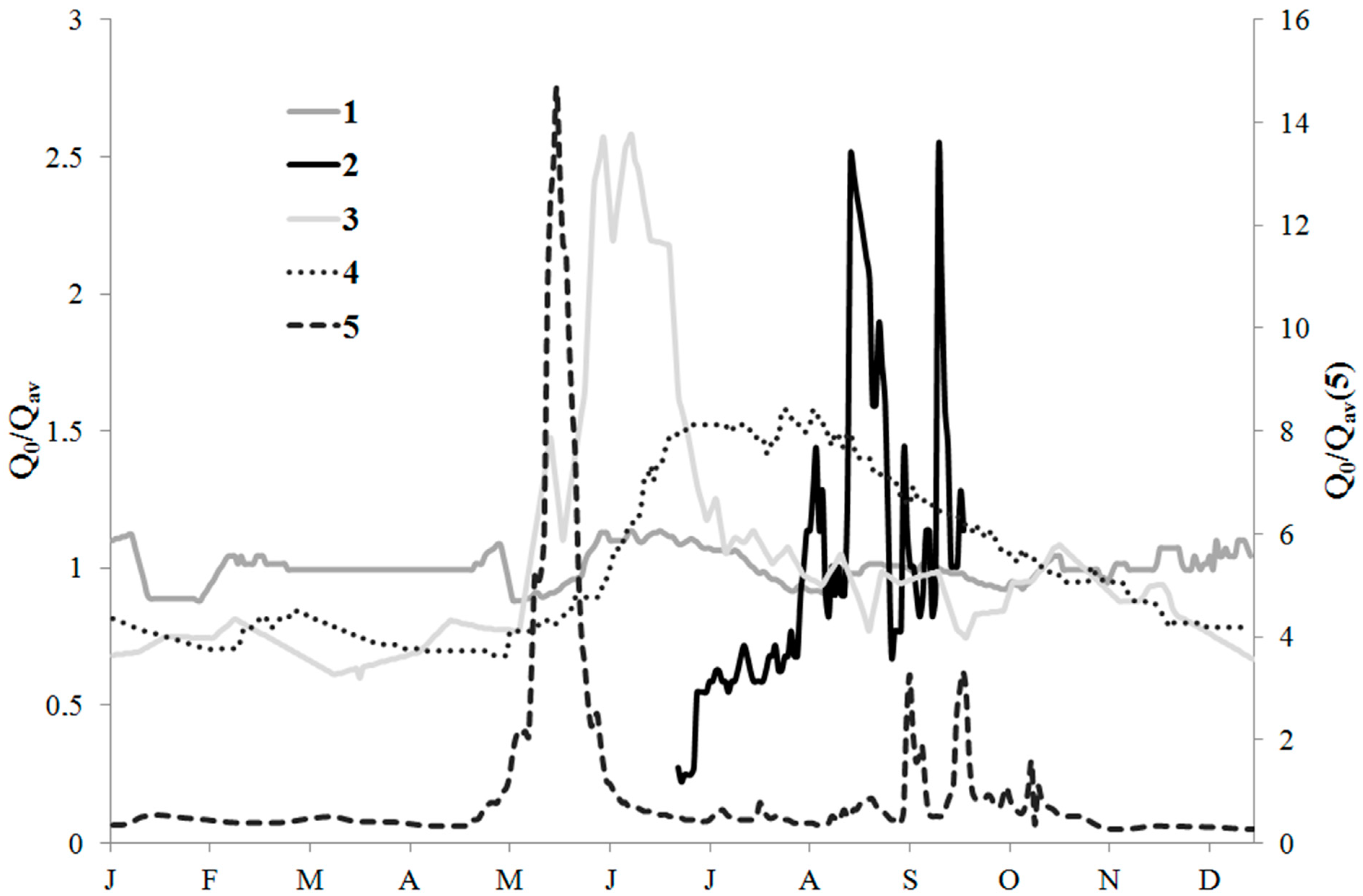
3.2. Azonal Types of Water Regime
There are rivers with azonal types of water regime in the Kamchatsky Krai territory. Their origin is connected with influences of various types of natural regulation of water runoff. The unique type of water regime characterizes rivers with even water runoff distribution within the year (Figure 6, line 1). This type of water regime characterizes small rivers in the Kamchatka River basin (The Nikolka Pervaya River, and etc.). Groundwater is the predominant runoff source in these rivers [11], and its contribution is about 90%). Rivers with this type of water regime have been described only theoretically before, and there were no actual measurements. Now, they are placed into the L’vovich classification of water regime types [73,76]. The Nikolka Pervaya River is characterized by the minimum ratio between maximum and minimum water discharges, and the coefficient of natural water runoff overregulation reaches regional maximum (0.6). This type of water regime usually characterizes small river basins, but it has rather wide distribution all over the world. Rivers with even distribution of water runoff within the year are found in Central Europe, in a belt from southern Finland across to the north of the Caspian Sea [15].
Some of the Kamchatkan rivers have azonal type of water regime due to infiltration of weak-pressured ground waters into their channels. These rivers are characterized by high coefficients of natural water runoff overregulation (0.6), evenness of the runoff distribution (ratio between maximum and minimum water discharges is 4), and heightened values of water runoff. The example of such a river is the Goryachaya River (Figure 6, line 3).
The azonal type of water regime is observed in rivers with runoff controlled by lakes (Figure 4, line 4). Rivers flowing from the large lakes (e.g., the Kronotckaya River, the Ozernaya River) are characterized by small ratios between maximum and minimum water discharges (2–3). They have maximum relative duration of flood period (58%). The coefficient of natural water runoff overregulation is 0.5. This type of water regime is usually found in rivers controlled by lakes (the Nile immediately after lakes Victoria, Kyoga and Albert, rivers draining the Great Lakes of North America, and etc.) [15].
Rivers with a high percentage of wetlands are also characterized by high coefficients of natural overregulation of the river runoff (Figure 6, line 5). The unevenness of the runoff is rather high (ratio between maximum and minimum water discharges is 30–50, and during some years reaches 85), and it does not depend on water content during the year. The relative duration of the high-water period is minimum in rivers with this type of water regime (13% of the year).
Rivers draining territories of active volcanism also have azonal types of water regimes. This type of water regime is characterized by interchange of periods of surface water runoff presence and absence in river channels (Figure 6, line 2). Stable water runoff is observed only during periods of intense snowmelt and precipitation. Episodic discharge is connected with very high water permeability of friable volcanic deposits and extremely high infiltration rates of the surface runoff into channel deposits on volcanic flanks. The appearance of the surface runoff depends on water saturation of the underground rocks. Excess water moves in river channels in case of full saturation of the underlying rocks. Release of the water from the channel into storages lead to the intensification of infiltration and, as a result, a decrease of the surface runoff.
Therefore, the variability of the water discharges has a wave-like behavior in river channels on volcanic flanks. Collapses of the edge parts of glaciers, creation or destruction of temporary dams, channel processes, and ice phenomena all influence the water cycle between channel and hyporheic zone systems of water movement and variability of water discharges in the lahar valleys. There are three zones associated with water discharge variability [77]: (1) increase of water discharge in the channel; (2) invariability or insignificant change; (3) periodical decrease of water discharges to zero values as the consequence of surface runoff infiltration into the underlying rocks [78]. The first variant of the runoff characteristic variability dominates in sections of mountain channels, where rivers are fed from their sources. Water transits in the lower course. A decrease of slopes and flow velocities leads to intensification of infiltration into underlying water systems. High infiltration promotes rapid decrease of water discharge in the river channel near volcanic flanks. According to observations in the Kirgurich River and the Sukhaya Khalaktyrskaya River, channel transition losses of water discharge of 0.1–0.2 m3/s finish completely in section of 100–200 m.
Endogenous processes could cause anomalous water discharge changes during some years. Rivers have higher discharge rates during volcanic eruptions, leading to intense snow and ice melting. The phase of reduced water runoff appears to be due to the degradation of snowpacks and glaciers as one of the main feeding sources. Rivers with this type of water regime are widely spread in volcanic regions [43,45,79].
4. Discussion
4.1. Distribution of the Mean Annual Specific Water Runoff and Specific Suspended Sediment Yield
The Kamchatsky Krai territory was divided into various regions with the similar mean annual specific water discharge and suspended sediment concentration. Characteristics of the relief, precipitation distribution, and soil-vegetation cover were also considered to set the boundaries.
Rivers in the Kamchatsky Krai have one the highest discharge rates of all rivers in the Russian Federation. The mean annual river runoff is estimated to be 235 km3 or 6% of the total river runoff in the Russian Federation [80,81]. The mean annual specific water discharge is 16.1 L s−1 km−2. The Kamchatka River has the maximum runoff factor among large rivers in the Russian Federation (0.72). The zone of the greatest water runoff is situated in the southern part of the Kamchatka peninsula. The mean annual specific water discharge exceeds 50 L s−1 km−2 there and reaches 95.9 L s−1 km−2 in the Pauzhetka River basin. These values are close to some river basins in Alaska, Norway, south-east Asia, north and center of the South America [82]. The same specific water discharge is also observed in the Caucasus river basins, in the upper streams of the Yenisey and Ob’ rivers [74]. Lower values (20–50 L s−1 km−2, see Figure 1a) of mean annual specific water discharge characterizes rivers in the south-west and eastern coast of the peninsula. The same values are observed in the eastern coast of the USA, in a central Africa [82]. In the territory of the Russian Federation similar specific water discharge distribution is characterized the downstream of the Yenisey River [74]. Low specific water discharges (less than 20 L s−1 km−2, see Figure 1a) cover river basins in the west of the peninsula and in the continental part of the Kamchatsky Krai. Such values of the specific water discharge are observed in the north of the Russian Federation [74]. On a global scale they are in southeast Africa, northeast Canada, and in the main part of European river basins [82]. The minimum specific water discharge is observed in rivers in the west of continental part (rivers that do not exceed 10 L s−1 km−2, see Figure 2a). The maximum specific water discharge (269 L s−1 km−2) characterizes the Nikolka Pervaya River (the west tributary of the Kamchatka River in the middle course), which is fed by groundwater mainly. The distribution of specific water discharge in the Kamchatsky Krai territory is mainly connected with precipitation in region (see Section 2.2) while other factors have secondary influence. Described distribution of the mean annual specific water discharge is close to [83] global generalization, with a small deviation of 7–12%.
This distribution of water runoff does not coincide with the distribution of suspended sediment concentration (SSC). Regions with the lowest SSCs (≤10 mg L−1, see Figure 2b) are located in the southwest part of the peninsula, in the central part of the Central Range, and in the isthmus between the peninsula and the continental part of the Kamchatka Krai (see Figure 2b). They are characterized by areas with highly resistant rock types that appear impervious to high levels of precipitation. Erosion is also limited by the presence of substantial vegetative cover.
SSCs of 11–50 mg L−1 characterize the western and southeastern parts of the peninsula as well as the continental Kamchatka (see Figure 2b). Soils in these areas display relatively low levels of erodibility as long as the bedrock is resistant to erosion. Similar values are observed in the main part of the Russian Federation including vast Siberia [14]. In a global scale such distribution of suspended sediment concentration is observed in the west Australia, north Canada, and north-east Africa [84].
Considerable increases in SSC have been observed in the eastern regions of the peninsula where active volcanoes are situated. Such a high values of suspended sediment concentration are observed in mountain regions of the former USSR [14], in some regions in the east of the North America, south-west Asia, and central Africa [84]. SSCs decrease with increasing distance from volcanic zones. The zone of maximum SSC coincides with the location of the Kliuchevskoy volcanic group (see Figure 2b). Close to volcanoes, SSCs can exceed values of 105–106 mg L−1, and for some rivers, it reaches values >2·105 mg L−1 (the maximum measured value is 6·105 mg L−1). Such elevated SSCs are associated with easily erodible bedrock, maximum values of soil erosion, the absence of vegetative cover, and high levels of precipitation. The SSF associated with the slopes and flanks of active volcanoes actually depend on the number and magnitude of volcanic eruptions. The maximum SSFs in the Kamchatka River were observed after major eruptions. In a global scale this distribution is also close to [83] the global generalization, with a deviation of 7–25%.
4.2. Hydrological Regions
There are 7 hydrological regions in the Kamchatsky Krai according to prevalent runoff source and water regime type. Five of them were determined in 1973, and the sixth region was marked out for the first time in this study—that is, the territory of the sixth and the seventh regions were joined before and considered as not studied (see Figure 5).
Analysis of water runoff hydrographs [70,72] demonstrates that the rivers of the northern hydrological region have snow that predominately feeds the rivers (60–70% of the annual river runoff), and this area is characterized by a spring–summer flood period and flash floods in the warm period of the year (see Figure 5I). Rivers of the western region have predominately underground sources (50–70% of the annual river runoff). This type of water regime is very close to group 4 in [15]. According to the authors of [73], this type is also observed in the upper Yenisey River. These rivers are characterized by a spring–summer flood period and flash floods in the warm period of the year (see Figure 5II). A similar hydrological regime also characterizes the Amur River in the upper and down streams, some rivers of the Primorsky Krai of the Russian Far East [73]. Rivers of the south-western region have combined sources (snow compounds 40–45, underground flow—35–45, and rain water—15–25% of the annual river runoff). The water regime of the rivers is characterized by a flood period and flash floods in the summer–autumn period (see Figure 5III). Rivers of the central region have predominately underground sources (50–70%); floods occur in the spring–summer period (see Figure 5IV). This type of hydrological regime is very close to group 3 in a global classification of hydrological regimes [15]. It’s also observed in some mountain river basins in the Caucasus mountains [73]. Rivers in the eastern region have predominately underground sources (50–70%). They are characterized by spring–summer floods and flash floods, which sometimes exceed maximum water discharges and levels of flood time (see Figure 5V). The similar hydrological regime characterizes the upper Ob’ River [73].
Regions VI and VII were previously not studied [8]. In 1980, in two rivers (the Karaga River, basin area is 1770 km2 and the Lyalaginvayam River, basin area is 262 km2) of the VI region, hydrological monitoring was started. Now, the available data allows us to reveal the main features of the hydrological regime of the region. The rivers are characterized by spring–summer floods and flash floods (see Figure 5VI). The coefficient of natural water runoff overregulation is 0.2–0.3 and is very close to the minimum values in the territory. The ratio between the maximum and minimum water discharges within the year varies from 11 to 221. Rivers have mixed feeding sources (with domination of underground and snow). These indicators are very similar with the IV hydrological region (see Figure 5).
According to a global classification of river regimes [15] there are only two hydrological regions in the studied territory. Their regime is close to hydrological regions II and IV (see Figure 5). L’vovich [73] divided five hydrological regions by various feeding sources and their distribution in the Kamchatsky Krai territory; they are close to [11]. Zaikov [75] only mentioned one type of hydrological regime in the region (the Tian Shan type; close to II hydrological region, see Figure 3) which is also observed in the mountain regions of the former USSR.
5. Conclusions
Rivers of the Kamchatsky Krai are some of the largest in the Russian Federation, and their runoff is about 6% of the total river runoff in the country. Most of the rivers in the region are characterized by two relatively long-term trends in water runoff and suspended sediment yield—that is, increases from the late 1970s to the early 1980s, followed by a subsequent decline (there is no dependence on basin area). Kamchatsky Krai can be divided into 9 specific water discharge (varies from less than 10 L s−1 km−2 to 269 L s−1 km−2 in the Nikolka Pervaya River basin) and 18 suspended sediment concentration (from less than 10 mg L−1 to values more than 105–106 mg L−1 [the maximum measured value is 6·105 mg L−1]) regions.
The existence of six hydrological regions in the Kamchatsky Krai territory were validated, given recent hydrometeorological data. They differ by their combination of various feeding sources, their ratios of characteristic water discharges, and their natural flow overregulation. Three types of zonal water regimes were described on the basis of these features and the duration of their high-water periods. The distribution of SSC mainly coincided with water discharge distribution within the year, and relative changes of SSC exceeded water discharge values.
Many rivers in the Kamchatsky Krai are characterized as having azonal types of water regime. These types appear as a consequence of natural flow regulation of zonal types of water regime. Some rivers in Kamchatka are mainly fed by groundwater. The coefficient of natural flow overregulation is heightened in rivers with wetlands in the basin area, flowing from large lakes, and fed by weak-pressed underground water. There are unique rivers draining volcanic flanks in Kamchatka. This type of water regime is characterized by a periodic extinction of the surface runoff and the consequent filling of channels by water in conditions of intense water cycle between channels and the underlying surface in lahar valleys.
The results of this study could be of wide interest to hydrologists, as it provides original and new information about variability and specific features of hydrological regime and sediment yield of rivers in the Kamchatsky Krai, which is difficult to access, in the current climatic conditions.
Funding
This research was funded by the RUSSIAN SCIENCE FOUNDATION, grant number 17-77-10047.
Acknowledgments
I’d like to say many thanks to my scientific supervisor Nikolay I. Alexeevsky with whom we started these studies, for his valuable advices and comments. I also express my gratitude to deputy director of Institute of Volcanology and Seismology in Kamchatka Yaroslav D. Muravyev for his assistance in field work organization and very productive discussions. I thank officers of Hydrometeorological Service in Kamchatsky Krai for their assistance in data base preparation.
Conflicts of Interest
The authors declare no conflict of interest.
References
- Wischmeier, W.H.; Smith, D.D. Predicting rainfall erosion losses: A guide to conservation planning. In Agriculture. Handbook; US Department of Agriculture: Washington, DC, USA, 1978; Volume 537. [Google Scholar]
- Muravyev, Y.D.; Klimenko, E.S.; Dmitrieva, Y.A. To creation GIS “Volcanic danger”. Arcview 2010, 2, 12–13. (In Russian) [Google Scholar]
- Ozerov, A.Y.; Karpov, G.A.; Droznin, V.A.; Dvigalo, V.N.; Demyanchuk, Y.V.; Ivanov, V.V.; Belousov, A.B.; Firstov, P.P.; Gavrilov, V.A.; Yashuk, V.V.; et al. The September 7–October 2, 1994 eruption of Klyuchevskoi Volcano, Kamchatka. Volcanol. Seismol. 1997, 18, 501–516. [Google Scholar]
- Neall, V.E. Volcanic soils. Land Use Land Cover Soil Sci. 2006, 7, 1–24. [Google Scholar]
- Sokolov, I.A. Volcanism and Soil Formation; Nauka: Moscow, Russia, 1973. (In Russian) [Google Scholar]
- Federal Agency on Fishery. Available online: http://www.fish.gov.ru (accessed on 25 November 2017).
- Dessouki, T.C.E. Water Quality Assessment of the Salmon River Near Hyder, Alaska (1990–2007). Available online: https://www2.gov.bc.ca/assets/gov/environment/air-land-water/water/waterquality/monitoring-water-quality/cariboo-skeena-omineca-wq-docs/wq_sk_salmon_hyder_2007.pdf (accessed on 20 November 2017).
- Young, D.B.; Woody, C.A. Spawning distribution of sockeye salmon in a glacially influenced watershed: The importance of glacial habitats. Trans. Am. Fish. Soc. 2007, 136, 452–459. [Google Scholar] [CrossRef]
- Huntington, T.G. Evidence for intensification of the global water cycle: Review and synthesis. J. Hydrol. 2006, 319, 83–95. [Google Scholar] [CrossRef]
- Karaushev, A.V. (Ed.) Sediment Yield, Its Study and Geographical Distribution; Gidrometeoizdat: Leningrad, Russia, 1977; 240p. (In Russian) [Google Scholar]
- Resursy Poverkhnostnykh vod SSSR. T. 20. Kamchatka (1973) (USSR Surface Water Resources, Volume 20, Kamchatka); Gidrometeoizdat: Leningrad, Russia, 1973. (In Russian) [Google Scholar]
- Dzhamalov, R.G.; Frolova, N.L.; Stanovova, A.V.; Krichevets, G.N.; Wang, C.H.; Kuo, C.H.; Feng, S.C.; Cheng, H.L.; Wu, M.-C. Current monsoon conditions of river runoff and groundwater formation in West Pacific regions: Kamchatka Peninsula and Taiwan Island. Water Resour. 2012, 39, 610–621. [Google Scholar] [CrossRef]
- Frolova, N.L.; Stanovova, A.V.; Gorin, S.L. Runoff regime in the lower reaches of the Kamchatka R. and its many-year variations. Issledovaniya Vodnykh Biologicheskikh Resursov Kamchatki I Severo-Zapadnoi Chasti Tikhogo Okeana (Stud. Aquatic Biol. Resour. Kamchatka R. Northwest. Pasific) 2014, 32, 73–78. (In Russian) [Google Scholar]
- Bobrovitskaya, N.N. Long-term variations in mean erosion and sediment yield from the rivers of the former Soviet Union. IAHS Publ. 1996, 236, 32–39. [Google Scholar]
- Haines, A.T.; Finlayson, B.L.; McMahon, T.A. A global classification of river regimes. Appl. Geogr. 1988, 8, 255–272. [Google Scholar] [CrossRef]
- Labat, D.; Godderis, Y.; Probst, J.L.; Guyot, J.L. Evidence for global runoff increase related to climate warming. Adv. Water Resour. 2004, 27, 631–642. [Google Scholar] [CrossRef] [Green Version]
- Korup, O.; Schmidt, J.; Mcsaveney, M.J. Regional relief characteristics and denudation pattern of the western Southern Alps, New Zealand. Geomorphology 2005, 71, 402–423. [Google Scholar] [CrossRef]
- Korup, O.; McSaveney, M.J.; Davies, T.R.H. Sediment generation and delivery from large historic landslides in the Southern Alps, New Zealand. Geomorphology 2004, 61, 189–207. [Google Scholar] [CrossRef]
- Korup, O.; Clague, J.J.; Hermanns, R.L.; Hewitt, K.; Strom, A.L.; Weidinger, J.T. Giant landslides, topography, and erosion. Earth Planet. Sci. Lett. 2007, 261, 578–589. [Google Scholar] [CrossRef]
- Golosov, V.N. Erosive and Accumulative Processes in River Basins of Developed Land; GEOS: Moscow, Russia, 2006; p. 296. (In Russian) [Google Scholar]
- Milliman, J.D.; Meade, R.H. World-wide delivery of river sediment to the oceans. J. Geol. 1983, 91, 1–21. [Google Scholar] [CrossRef]
- Ludwig, W.; Probst, J.L. A Global Modelling of the Climatic, Morphological, and Lithological Control of River Sediment Discharge to the Oceans. IAHS Publ. 1996, 236, 21–28. [Google Scholar]
- Ahnert, F. Functional relationships between denudation, relief, and uplift in large mid-latitude drainage basins. Am. J. Sci. 1970, 208, 243–263. [Google Scholar] [CrossRef]
- Chakrapani, G.J. Factors controlling variations in river sediment loads. Curr. Sci. 2005, 88, 569–575. [Google Scholar]
- Langbein, W.B.; Schumm, S.A. Yield of sediment in relation to mean annual precipitation. Trans. Am. Geophys. Union 1958, 39, 1076–1084. [Google Scholar] [CrossRef]
- Meade, R.H.; Parker, R.S. Sediment in rivers of the United States. U.S. Geol. Surv. Water Pap. 1984, 2275, 49–60. [Google Scholar]
- Dedkov, A.P.; Mozherin, V.I. Erosion and Sediment Yield in Mountain Regions of the World. IAHS Publ. 1992, 209, 29–36. [Google Scholar]
- Dedkov, A.P.; Mozherin, V.I. Erosion and Sediment Yield on the Earth. IAHS Publ. 1998, 236, 29–33. [Google Scholar]
- Rey, F. Influence of vegetation distribution on sediment yield in forested marly gullies. Catena 2003, 50, 549–562. [Google Scholar] [CrossRef]
- Shit, P.K.; Bhunia, G.S.; Maiti, R. Vegetation Influence on Runoff and Sediment Yield in the Lateritic Region: An Experimental Study. J. Geogr. Nat. Disast. 2014, 4, 116. [Google Scholar] [CrossRef]
- Ludwig, W.; Probst, J.L. River sediment discharge to the oceans: Present-day controls and global budgets. Am. J. Sci. 1998, 298, 265–295. [Google Scholar] [CrossRef]
- Korup, O. Landslide-induced river channel avulsions in mountain catchments of southwest New Zealand. Geomorphology 2004, 63, 57–80. [Google Scholar] [CrossRef]
- Dadson, S.J.; Hovius, N.; Dade, W.B.; Lin, J.C.; Hsu, M.L.; Lin, C.W.; Horng, M.J.; Chen, T.C.; Milliman, J.; Stark, C.P. Earthquake-triggered increase in sediment delivery from an active mountain belt. Geology 2004, 32, 733–736. [Google Scholar] [CrossRef]
- Collins, N.J. The effects of volcanic activity on the vegetation of Deception Island. Br. Antarct. Surv. Bull. 1969, 21, 79–94. [Google Scholar]
- Neshataeva, V.Y. Vegetable cover of Kamchatka Peninsula and its geobotanical regionalization. Proc. Karelian Res. Center RAS 2011, 1, 3–22. [Google Scholar]
- Lavigne, F.; Thouret, J.C. Sediment transportation and deposition by rainfall triggered lahars at Merapi Volcano, Central Java, Indonesia. Geomorphology 2002, 49, 45–69. [Google Scholar] [CrossRef]
- Manville, V.; Newton, E.H.; White, J.D.L. Fluvial responses to volcanism: Resedimentation of the 1800a Taupo ignimbrite eruption in the Rangitaiki River catchment, North Island, New Zealand. Geomorphology 2005, 65, 49–70. [Google Scholar] [CrossRef]
- Korup, O.; Clague, J.J. Natural hazards, extreme events, and mountain topography. Quat. Sci. Rev. 2009, 28, 977–990. [Google Scholar] [CrossRef]
- Gran, K.B.; Montgomery, D.R. Spatial and temporal patterns in fluvial recovery following volcanic eruptions: Channel response to basin-wide sediment loading at Mount Pinatubo, Philippines. GSA Bull. 2005, 117, 195–211. [Google Scholar] [CrossRef]
- Chalov, S.; Belozerova, E.; Shkolny, D.; Romanchenko, A.; Piotrovsky, A. Sediment transfer in the extreme volcanic environment (case study of the Kamchatka peninsula). In Advances in River Sediment Research; Fukuoka, S., Nakagawa, H., Sumi, T., Zhang, H., Eds.; Taylor & Francis Group: London, UK, 2013; p. 73. [Google Scholar]
- Major, J.J.; Mark, L.E. Peak flow responses to landscape disturbances caused by the cataclysmic 1980 eruption of Mount St. Helens, Washington). GSA Bull. 2006, 118, 938–958. [Google Scholar] [CrossRef]
- Romanescu, G.; Chalov, S.; Stoleriu, C.; Mihu-Pintilie, A.; Cama, M.; Angileri, S.; Kuznetsova, Y.; Marker, M. Geomorphologic map of the 1st Mutnaya River, Southeastern Kamchatka, Russia. J. Mt. Sci. 2017, 14, 2373–2390. [Google Scholar] [CrossRef]
- Major, J.J.; Pierson, T.C.; Dinehart, R.L.; Costa, J.E. Sediment yield following severe volcanic disturbance—A two-decade perspective from Mount St. Helens. Geology 2000, 20, 819–822. [Google Scholar] [CrossRef]
- Major, J.J. Posteruption suspended sediment transport at Mount St. Helens: Decadal-scale relationships with landscape adjustments and river discharges. J. Geophys. Res. 2004, 109, F01002. [Google Scholar] [CrossRef]
- Hayes, S.K.; Montgomery, D.R.; Newhall, C.G. Fluvial sediment transport and deposition following the 1991 eruption of Mount Pinatubo. Geomorphology 2002, 45, 211–224. [Google Scholar] [CrossRef] [Green Version]
- Kouzin, P.S.; Babkin, V.I. The Geographical Laws of Hydrologic Regime of Rivers; Hydrometeoizdat: Leningrad, Russia, 1979. (In Russian) [Google Scholar]
- Kuksina, L.V.; Alexeevsky, N.I. Suspended sediment yield transportation by rivers of the Kamchatsky Krai into the Pacific Ocean, the Sea of Okhotsk and the Bering Sea. J. River Basin Manag. 2018. [Google Scholar] [CrossRef]
- Smakthin, V.U. Low flow hydrology: A review. J. Hydrol. 2001, 240, 147–186. [Google Scholar] [CrossRef]
- Kuksina, L.V.; Alexeevsky, N.I. Spatial and temporal variability of suspended sediment yield in the Kamchatka Krai, Russian Federation. IAHS Publ. 2014, 367, 304–311. [Google Scholar] [CrossRef]
- Internet Archive. Available online: http://web.archive.org/web/20110127173856/ (accessed on 12 December 2017).
- Piip, B.I. Avachinsky Volcano eruption in 1945. Bull. Volcanol. Stn. 1953, 17, 6–23. (In Russian) [Google Scholar]
- Dodd, M.B.; Lauenroth, W.K. The influence of soil texture on the soil water dynamics and vegetation structure of a shortgrass steppe ecosystem. Plant Ecol. 1997, 133, 13–28. [Google Scholar] [CrossRef]
- Brown, A.E.; Zhang, L.; McMahon, T.A.; Western, A.W.; Vertessy, R.A. A review of paired catchment studies for determing changes in water yield resulting from alterations in vegetation. J. Hydrol. 2005, 310, 28–61. [Google Scholar] [CrossRef]
- Dow, C.L. Assessing regional land-use/cover influences on New Jersey Pinelands streamflow through hydrograph analysis. Hydrol. Process. 2007, 21, 185–197. [Google Scholar] [CrossRef]
- Jones, J.A.; Post, D.A. Seasonal and successional streamflow response to forest cutting and regrowth in the northwest and eastern United States. Water Resour. Res. 2004, 40, W05203. [Google Scholar] [CrossRef]
- Kamchatsky Krai—Local History Site. Available online: www.kamchatsky-krai.ru (accessed on 17 October 2017).
- Kuksina, L.V.; Alexeevsly, N.I. Suspended Sediment Yield of Rivers in the Kamchatsky Krai; MSU: Moscow, Russia, 2015. (In Russian) [Google Scholar]
- SPNT of Russia. Available online: www.oopt.aari.ru (accessed on 17 October 2017).
- Edwards, T.K.; Glysson, G.D. Field Methods for Measurement of Fluvial Sediment: U.S. Geological Survey Techniques of Water–Resources Investigations, Book 3, Chapter C2; U.S. Geological Survey: Reston, VA, USA, 1999. Available online: http://pubs.usgs.gov/twri/twri3-c2/ (accessed on 17 October 2017).
- Instructions for Hydrometeorological Stations and Gauges. V. 2 (2); Gidrometeoizdat: Leningrad, Russia, 1973. (In Russian)
- Instructions for Hydrometeorological Stations and Gauges. V. 6 (1); Gidrometeoizdat: Leningrad, Russia, 1978. (In Russian)
- Miller, S. Handbook for Agrohydrology; Natural Resources Institute: London, UK, 1994. [Google Scholar]
- Miyamoto, K.; Kurihara, J.; Sawada, T.; Itakura, Y. A study of field methods for measuring sediment discharge. IAHS Publ. 1992, 210, 107–115. [Google Scholar]
- Helsel, D.R.; Hirsch, R.M. Statistical Methods in Water Resources; Elsevier: Amsterdam, the Netherlands, 1992. [Google Scholar]
- Bowman, K.O.; Shenton, L.R. Estimator: Method of moments. In Encyclopedia of Statistical Sciences; Wiley: New York, NY, USA, 1998; pp. 2091–2098. [Google Scholar]
- Hogg, R.V.; Craig, A.T. Introduction to Mathematical Statistics, 4th ed.; Maccmillan: New York, NY, USA, 1978. [Google Scholar]
- Hristoforov, A.V. The Theory of Stochastic Processes in Hydrology; MSU Press: Moscow, Russia, 1994. (In Russian) [Google Scholar]
- Evstigneev, V.M. River Runoff and Hydrological Estimations; MSU Press: Moscow, Russia, 1990. (In Russian) [Google Scholar]
- Manh, N.V.; Merz, B.; Apel, H. Sedimentation monitoring including uncertainty analysis in complex floodplains: A case study in the Mekong Delta. Hydrol. Earth Syst. Sci. 2013, 17, 3039–3057. [Google Scholar] [CrossRef]
- Barnes, B.S. Analysis of runoff characteristics. Trans. Am. Soc. Civ. Eng. 1940, 109, 104–106. [Google Scholar]
- Brodie, R.S.; Hostetler, S. A review of techniques for analysing baseflow from stream hydrographs. In Proceedings of the NZHS—IAH—NZSSS 2005 Conference, Auckland, New Zealand, 28 November–2 December 2005. [Google Scholar]
- Linsley, R.K.; Kohler, M.A.; Paulhus, I.L.H. Hydrology for Engineers; McGraw-Hill: New York, NY, USA, 1988. [Google Scholar]
- L’vovich, M.I. The Hydrosphere. In World Water Resources and Their Future; American Geophysical Union: Washington, DC, USA, 1979. [Google Scholar]
- Zaykov, B.D. Average Water Runoff and Its Distribution in the USSR Territory; Gidrometeoizdat: Leningrad, Russia, 1946; 148p. (In Russian) [Google Scholar]
- Beckinsale, R.P. River regimes. Water Earth Man 1969, 455–471. [Google Scholar]
- Luk’yanovich, M.A. The genetic and seasonal structures of river runoff of the continents. Geogr. Nat. Resour. 2011, 3, 125–133. [Google Scholar] [CrossRef]
- Stott, T.A.; Grove, J.R. Short-term discharge and suspended sediment fluctuations in the proglacial Skeldal River, north-east Greenland. Hydrol. Process 2001, 15, 407–423. [Google Scholar] [CrossRef]
- Vinogradov, V.N.; Muravyev, Y.D. Kozel’sky Glacier (Avacha Volcanoes Group); Gidrometeoizdat: St. Petersburg, Russia, 1992. (In Russian) [Google Scholar]
- Koppes, M.N.; Montgomery, D.R. The relative efficacy of fluvial and glacial erosion over modern to orogenic timescales. Nat. Geosci. 2009, 2, 644–647. [Google Scholar] [CrossRef]
- Mikhailov, V.N.; Dobrovol’skii, A.G.; Dobrolyubov, S.A. Gidrologiya: Uchebnik dlya vuzov (Hydrology: A Textbook for Higher Education Institutions); Vyssh. shk: Moscow, Russia, 2007. (In Russian) [Google Scholar]
- Voskresenskii, K.P. Norma i Izmenchivost’ Godovogo stoka rek Sovetskogo Soyuza (Mean Values and Variations of the Annual River Runoff in the Soviet Union); Gidrometeoizdat: Leningrad, Russia, 1962. (In Russian) [Google Scholar]
- Fekete, B.M.; Vorosmarty, C.J.; Grabs, W. High-resolution fields of global runoff combining observed river discharge and simulated water balances. Glob. Biogeochem. Cycles 2002, 16, 1042. [Google Scholar] [CrossRef]
- Milliman, J.D.; Farnsworth, K.L. River Discharge to the Coastal Ocean: A Global Synthesis; Cambridge University Press: Cambridge, UK, 2013. [Google Scholar]
- Walling, D.E.; Webb, B.W. Erosion and sediment yield: A global overview. IAHS Publ. 1996, 236, 3–19. [Google Scholar]
- Dedkov, A.P.; Gusarov, A.V. Suspended Sediment Yield from Continents into the World Ocean: Spatial and Temporal Changeability. IAHS Publ. 2006, 306, 3–11. [Google Scholar]
- Syvitski, J.P.M.; Vorosmarty, C.J.; Kettner, A.J.; Green, P. Impact of humans on the flux of terrestrial sediment to the Global Coastal Ocean. Science 2005, 308, 376–380. [Google Scholar] [CrossRef] [PubMed]
Figure 1.
Study region of the Kamchatsky Krai and rivers mentioned in the paper.

Figure 2.
Distribution of monitoring stations measuring water discharge and specific water discharge (a) and suspended sediment yield and suspended sediment concentration (b) in the Kamchatsky Krai. Rivers: 1—Paren’, 2—Pakhacha, 3—Penzhina, 4—Avacha, 5—Talovka, 6—Tigil’, 7—Udova, 8—Asacha, 9—Bol’shaya Vorovskaya, 10—Bol’shaya (Bystraya), 11—Bryumka, 12—Phchyn, 13—Voyampolka, 14—Vyvenka, 15—Zhupanova, 16—Icha, 17—Kamchatka, 18—Kronotckaya, 19—Oblukovina, 20—Ozernaya, 21—Ozernaya, 22—Palana, 23—Khairyuzova.

Figure 3.
Duration of observations on monitoring stations measuring water discharge (a) and suspended sediment yield (b) in the Kamchatsky Krai.
Figure 3.
Duration of observations on monitoring stations measuring water discharge (a) and suspended sediment yield (b) in the Kamchatsky Krai.

Figure 4.
Trends in water discharge (1, St1), precipitation (2, St1) and suspended sediment yield (3, St2) variability in the Penzhina River (Kamenskoe gauge, (a)), the Khairyuzova River (Khairyuzovo gauge, (b)), the Udova River (Rus’ gauge, (c)), the Avacha River (Elizovo gauge, (d)), the Kirganick River (Kirganick gauge, (e)), the Kamchatka River (Bol’shie Sheki gauge, (f)).

Figure 5.
Distribution of hydrological regions in Kamchatsky Krai [11] and typical hydrographs and sedigraphs in these regions. Regions: I—Northern, II—Western, III—South-western, IV—Central, V—Eastern, VI—North-eastern, VII—not studied.
Figure 5.
Distribution of hydrological regions in Kamchatsky Krai [11] and typical hydrographs and sedigraphs in these regions. Regions: I—Northern, II—Western, III—South-western, IV—Central, V—Eastern, VI—North-eastern, VII—not studied.

Figure 6.
Relative variability of water discharges in rivers with azonal types of water regime. 1—the Nikolka Pervaya River, 2—the Kozel’sky River, 3—the Goryachaya River, 4—the Kronotckaya River, 5—the Bryumka River.
Figure 6.
Relative variability of water discharges in rivers with azonal types of water regime. 1—the Nikolka Pervaya River, 2—the Kozel’sky River, 3—the Goryachaya River, 4—the Kronotckaya River, 5—the Bryumka River.

© 2018 by the author. Licensee MDPI, Basel, Switzerland. This article is an open access article distributed under the terms and conditions of the Creative Commons Attribution (CC BY) license (http://creativecommons.org/licenses/by/4.0/).
Share and Cite
MDPI and ACS Style
Kuksina, L. Variations of Water Runoff and Suspended Sediment Yield in the Kamchatsky Krai, Russia. Water 2018, 10, 1451. https://doi.org/10.3390/w10101451
AMA Style
Kuksina L. Variations of Water Runoff and Suspended Sediment Yield in the Kamchatsky Krai, Russia. Water. 2018; 10(10):1451. https://doi.org/10.3390/w10101451
Chicago/Turabian StyleKuksina, Ludmila. 2018. "Variations of Water Runoff and Suspended Sediment Yield in the Kamchatsky Krai, Russia" Water 10, no. 10: 1451. https://doi.org/10.3390/w10101451
Note that from the first issue of 2016, this journal uses article numbers instead of page numbers. See further details here.