

Evaluation and System Coupling of Beautiful Qinghai–Tibet Plateau Construction Based on Point of Interest Data
 ,
,
Abstract
:1. Introduction
2. Materials and Methods
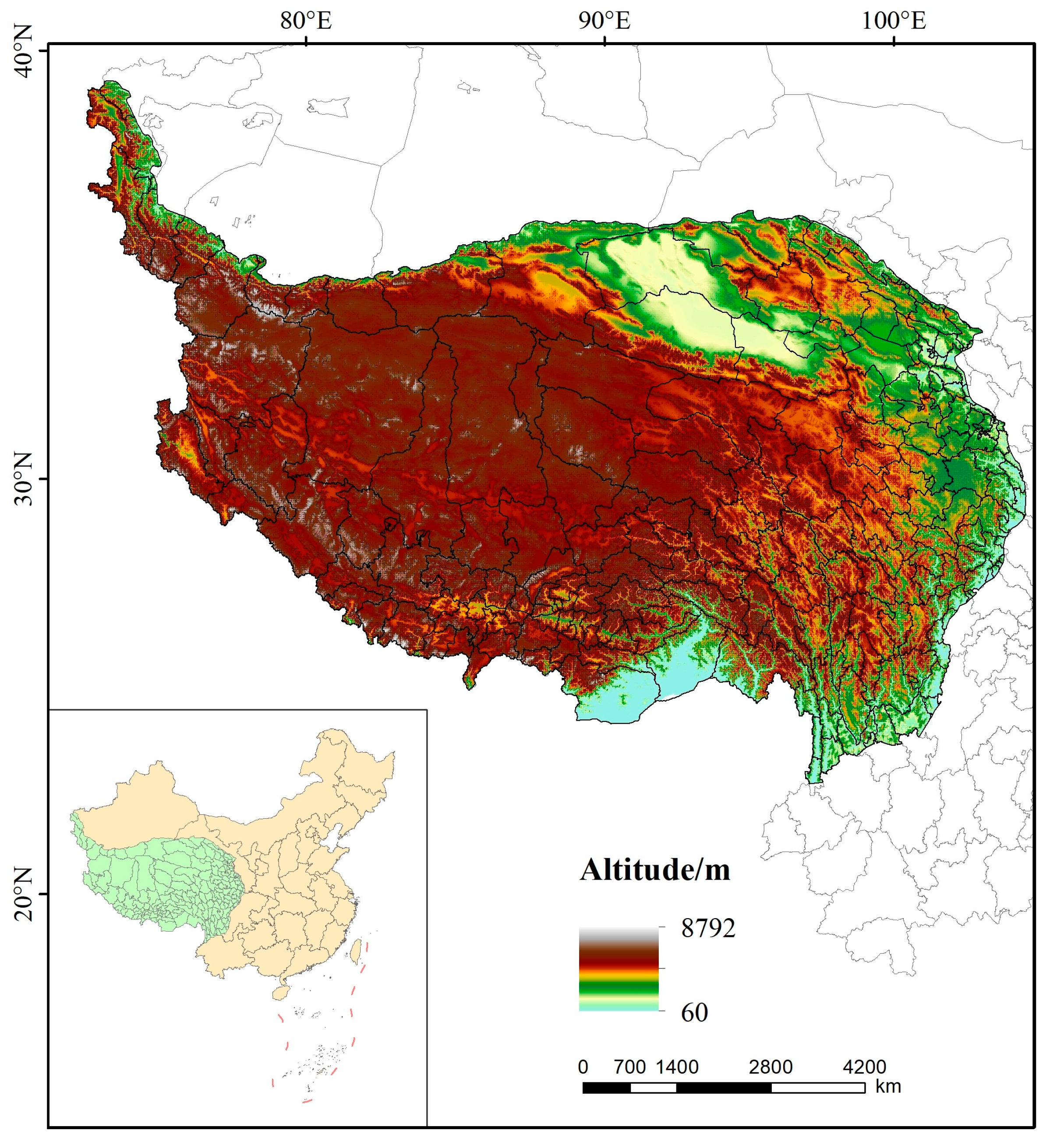
2.1. The Study Area
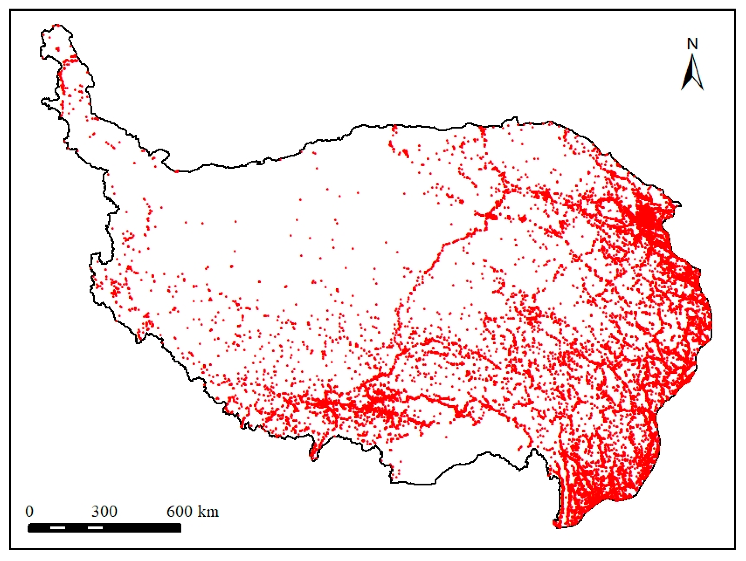
2.2. Data Sources
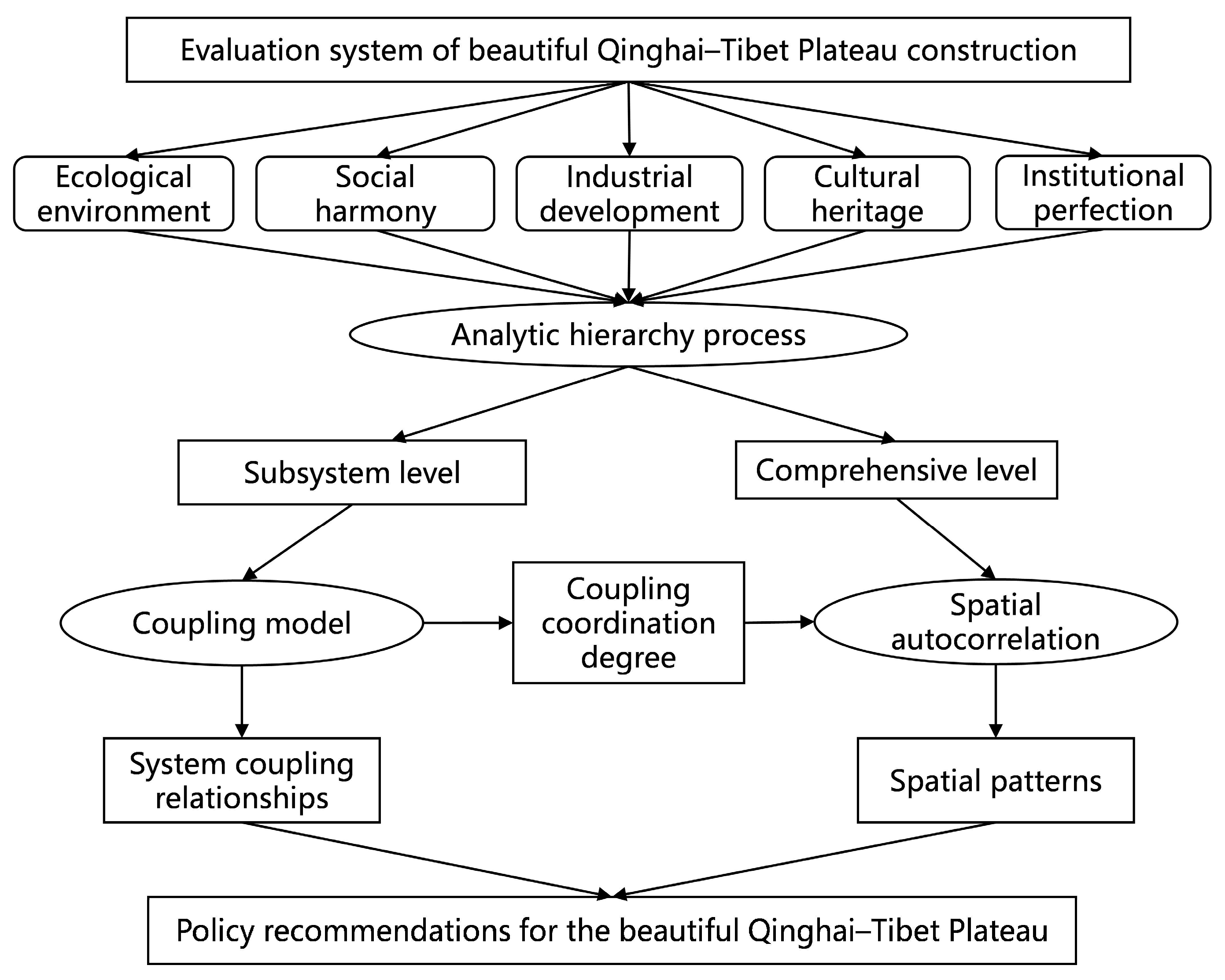
2.3. Research Route
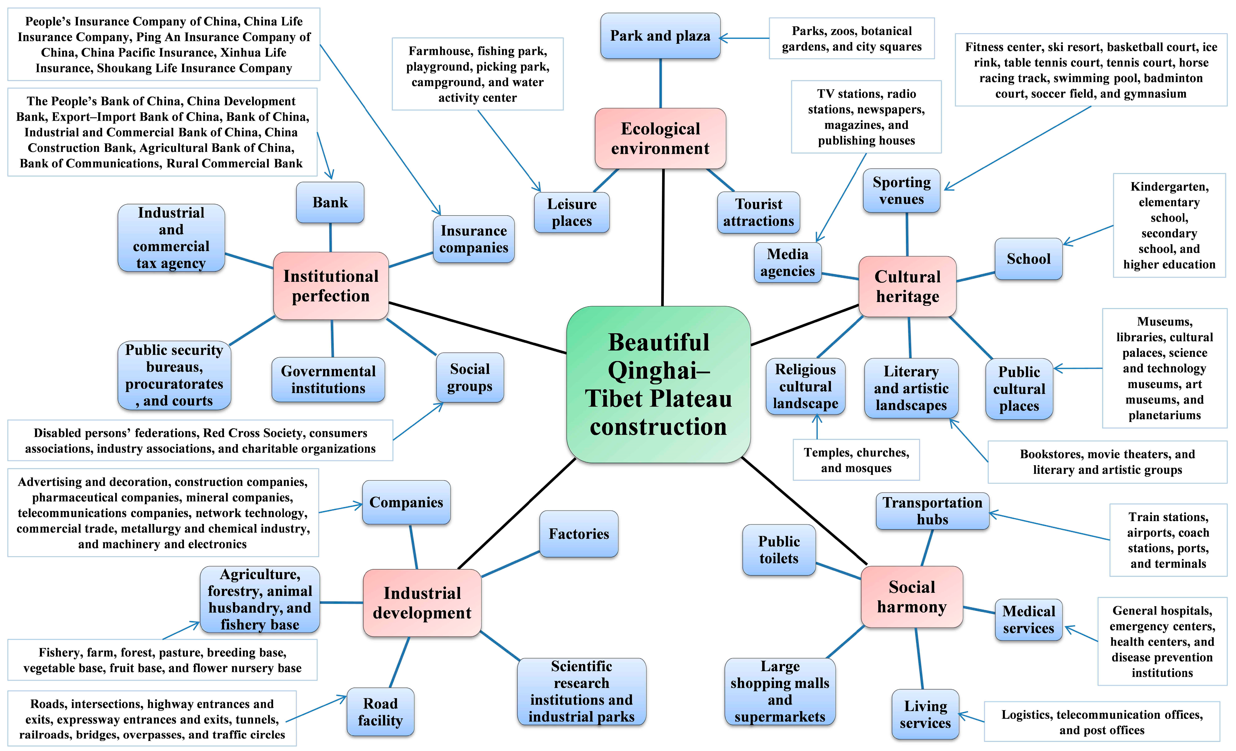
2.4. Establishment of Evaluation Index System
2.5. Evaluation of Beautiful Qinghai–Tibet Plateau Construction
2.5.1. Data Standardization
2.5.2. Allocation of Evaluation Index Weights
2.5.3. Calculation of the Evaluation Index
2.6. Coupling Model
2.6.1. Calculation of the Coupling Degree
2.6.2. Calculation of the Coupling Coordination Degree
2.7. Spatial Autocorrelation Analysis
3. Results
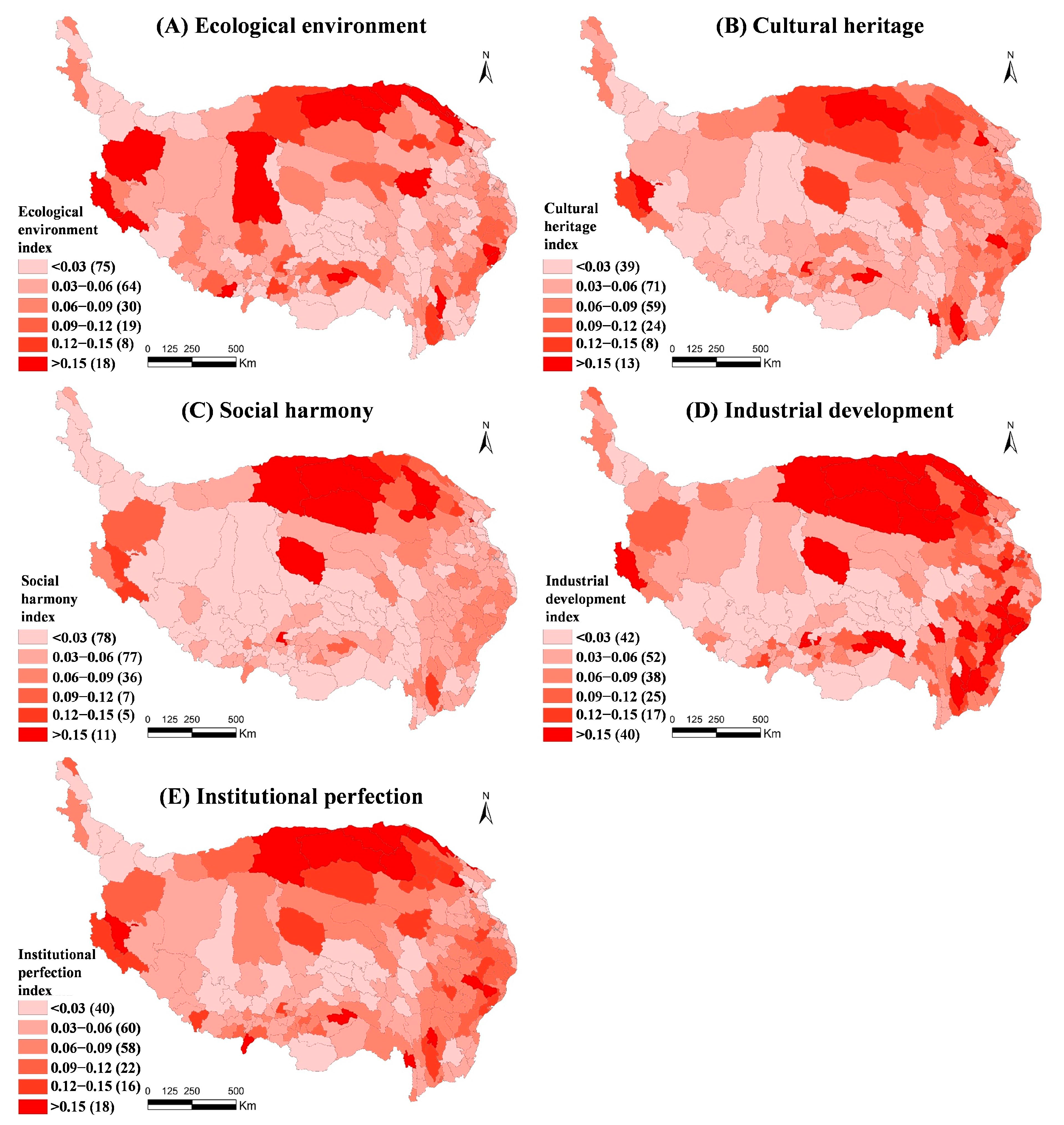
3.1. Subsystem Level of the Beautiful Qinghai–Tibet Plateau Construction
3.1.1. Ecological Environment
3.1.2. Cultural Heritage
3.1.3. Social Harmony
3.1.4. Industrial Development
3.1.5. Institutional Perfection
3.2. Comprehensive Level of the Beautiful Qinghai–Tibet Plateau Construction
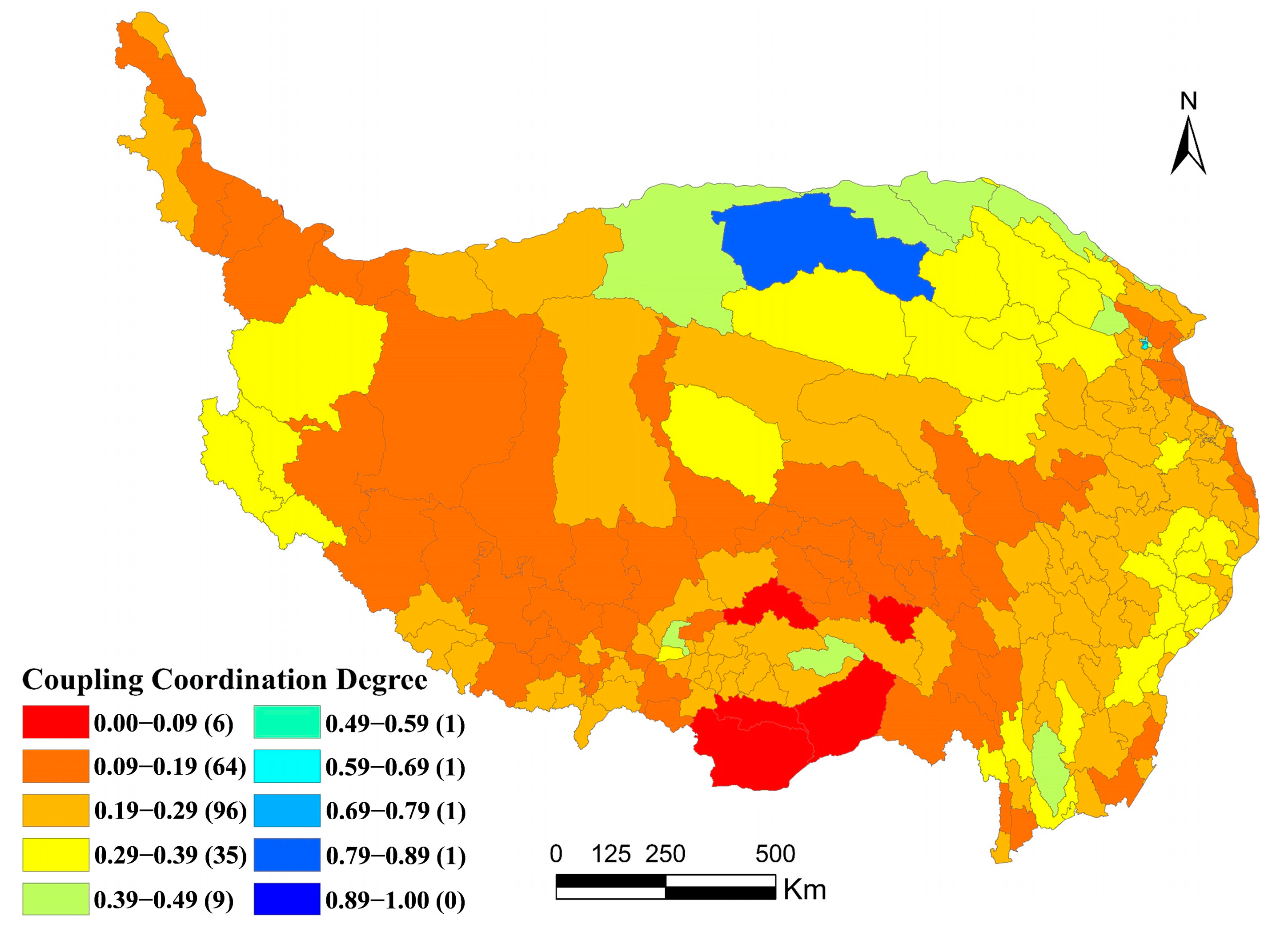
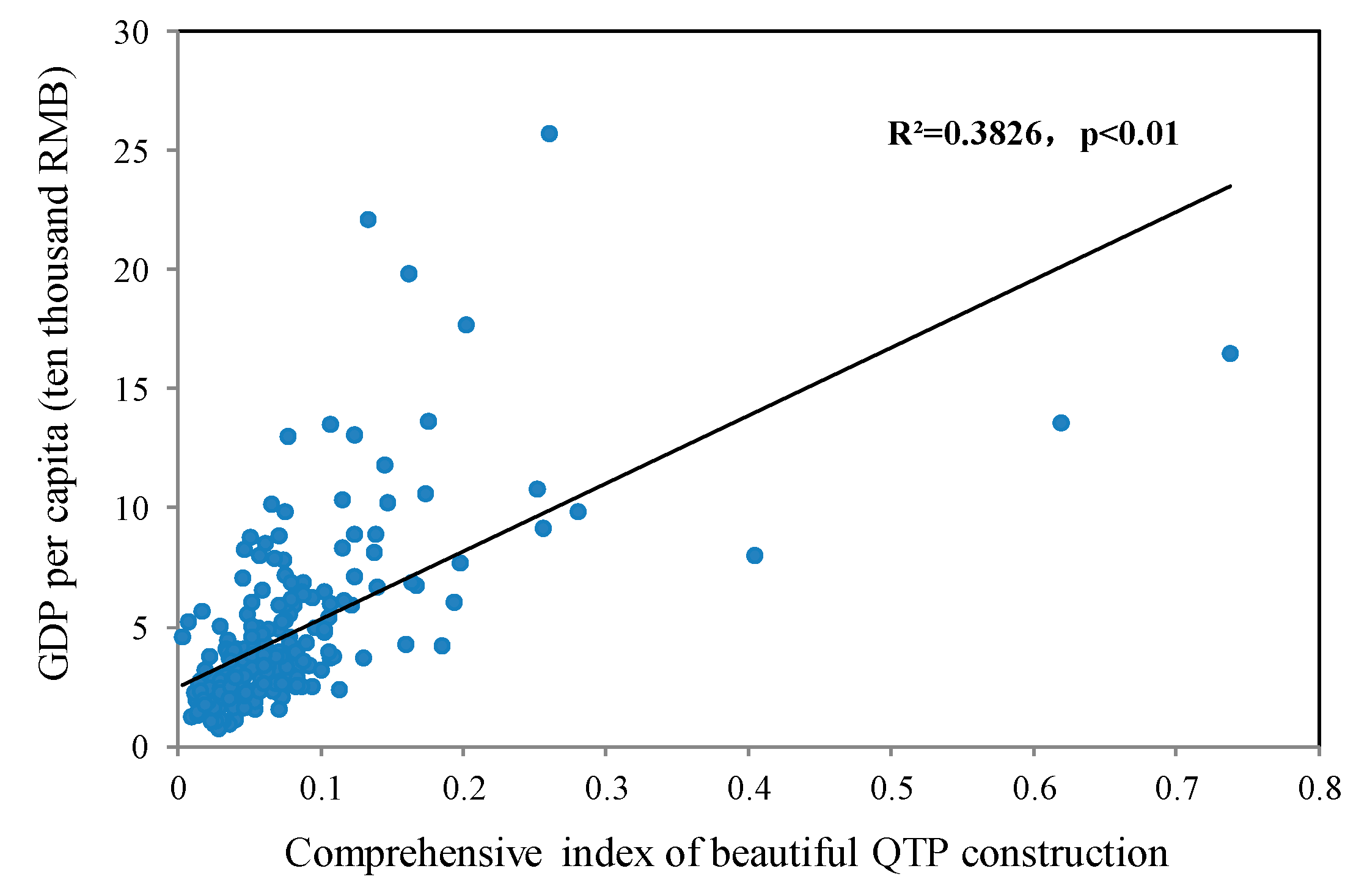
3.3. Coupling Relationships of the Beautiful Qinghai–Tibet Plateau Construction System
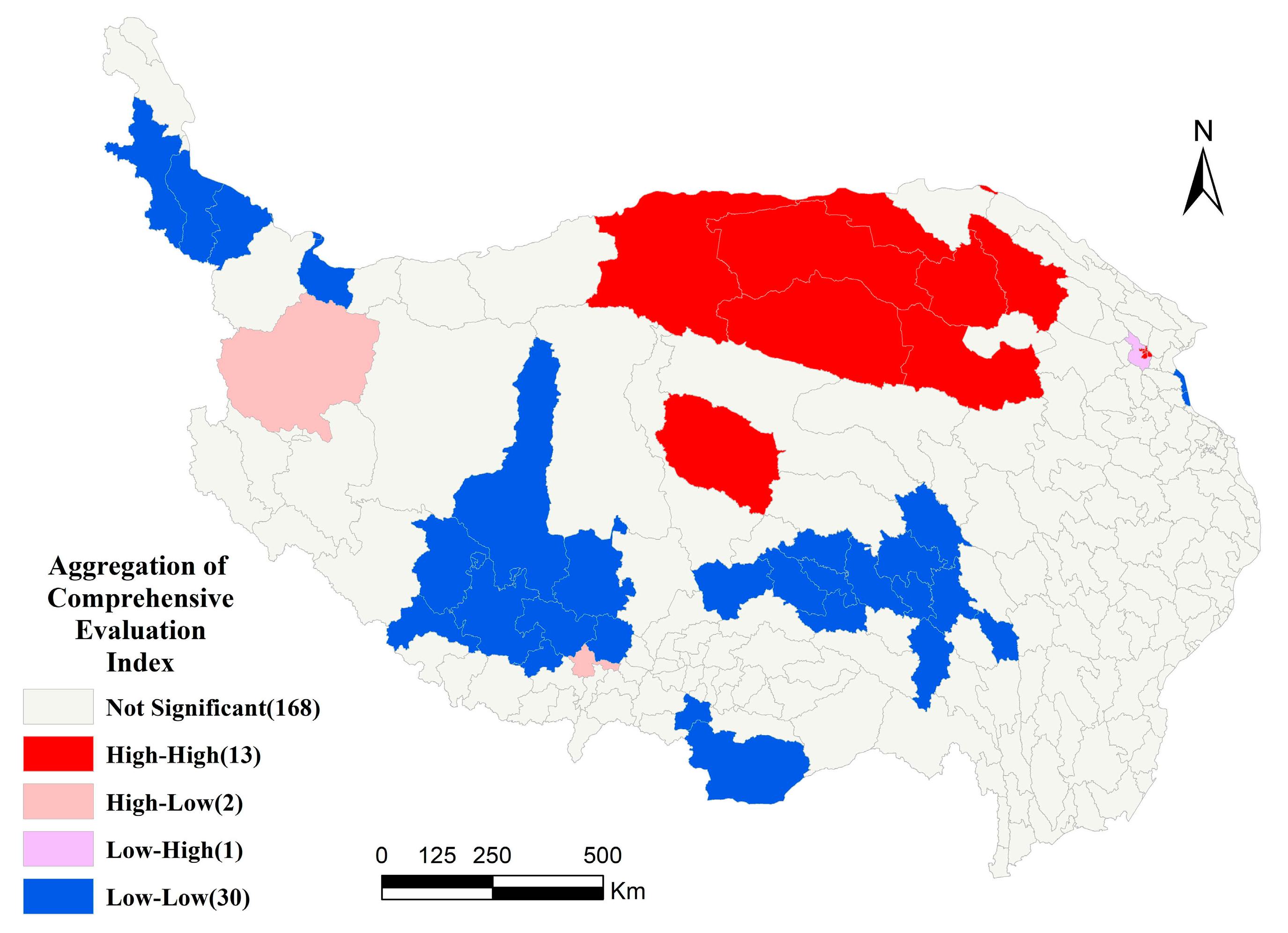
3.4. Spatial Autocorrelation of Comprehensive Index and Coupling Coordination Degree
3.4.1. Global Spatial Autocorrelation
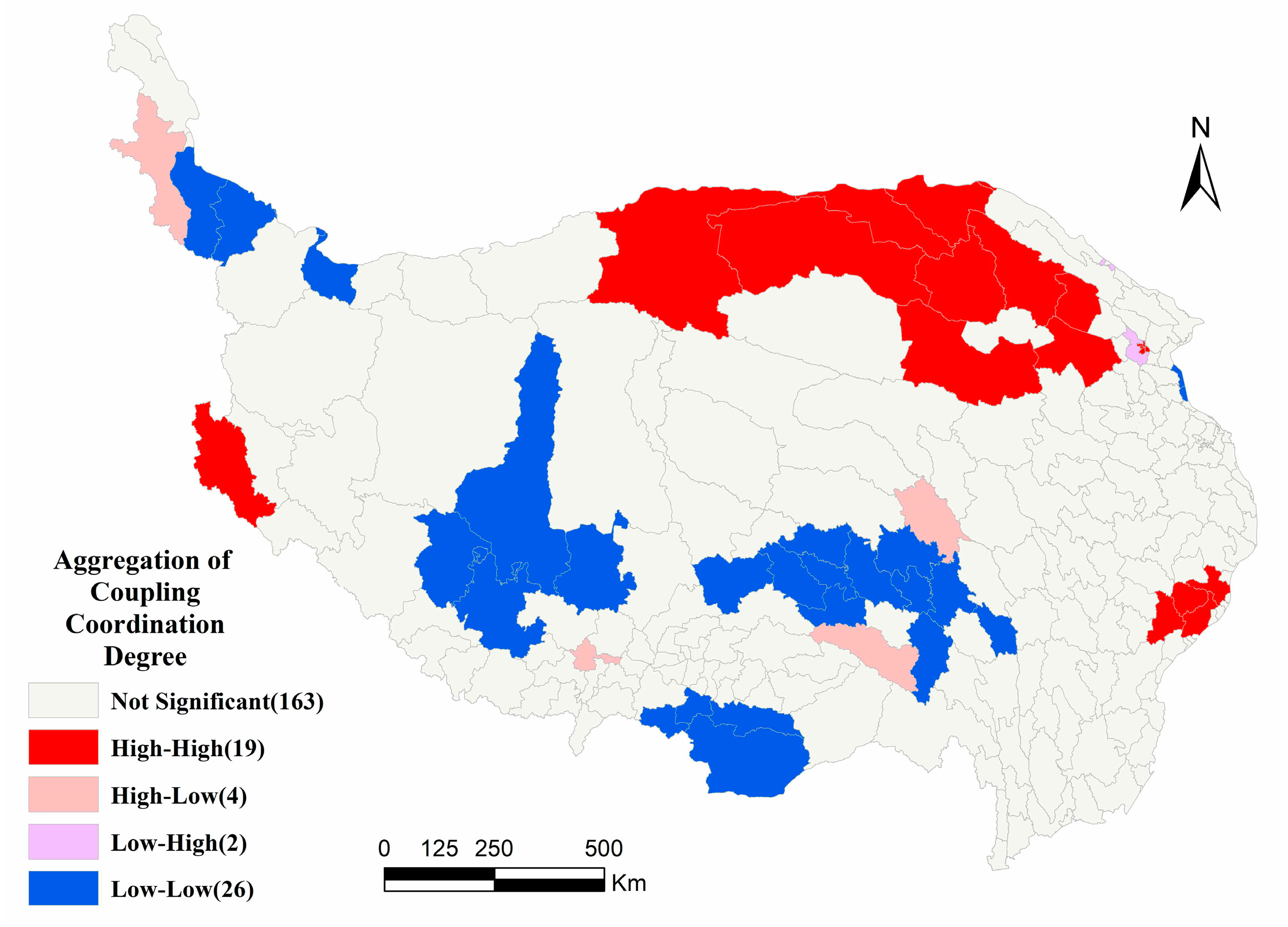
3.4.2. Local Spatial Autocorrelation
4. Discussion
4.1. Methodological Advantages and Concerns
4.2. Policy Recommendations
5. Conclusions
Author Contributions
Funding
Institutional Review Board Statement
Informed Consent Statement
Data Availability Statement
Conflicts of Interest
References
- Yao, Y.; Yueh, L. Law, Finance, and Economic Growth in China: An Introduction. World Dev. 2009, 37, 753–762. [Google Scholar] [CrossRef]
- Xie, Z.H. China’s historical evolution of environmental protection along with the forty years’ reform and opening-up. Environ. Sci. Ecotechnol. 2020, 1, 100001. [Google Scholar] [CrossRef]
- Sun, D.; Zhang, J.; Hu, Y.; Jiang, J.; Zhou, L. Spatial analysis of China’s eco-environmental quality: 1990–2010. J. Geogr. Sci. 2013, 23, 695–709. [Google Scholar] [CrossRef]
- Wang, Y. Environmental degradation and environmental threats in China. Environ. Monit. Assess. 2004, 90, 161–169. [Google Scholar] [CrossRef]
- Ma, K. Unswervingly Promote the Construction of Ecological Civilization. Qiushi 2013, 9, 3–9. (In Chinese) [Google Scholar]
- Gu, S.; Hu, Y.; Zhou, H. Ecological civilization construction: Scientific connotation and basic paths. Resour. Sci. 2013, 35, 2–13. (In Chinese) [Google Scholar]
- Dong, F.; Pan, Y.; Zhang, X.; Sun, Z. How to Evaluate Provincial Ecological Civilization Construction? The Case of Jiangsu Province, China. Int. J. Environ. Res. Public Health 2020, 17, 5334. [Google Scholar] [CrossRef]
- Wang, X. Constructing a beautiful China under the idea of ecological civilization. J. Beijing Nor. Univ. 2013, 2, 19–25. (In Chinese) [Google Scholar]
- Hu, J. Unswervingly Advance along the Road of Socialism with Chinese Characteristics, and Strive to Build a Moderately Prosperous Society in an All-Round Way: A Report at the 18th National Congress of the Communist Party of China; Beijing People’s Press: Beijing, China, 2012. [Google Scholar]
- Wan, J. The philosophical wisdom and action implications of “beautiful China”. Soc. Sci. China 2013, 34, 143–153. [Google Scholar]
- Fang, C.L.; Wang, Z.B.; Liu, H.M. Beautiful China Initiative: Human-nature harmony theory, evaluation index system and application. J. Geogr. Sci. 2020, 30, 691–704. [Google Scholar] [CrossRef]
- Chen, M.; Liang, L.; Wang, Z.; Zhang, W.; Yu, J.; Liang, Y. Geographical thoughts on the relationship between ‘Beautiful China’ and land spatial planning. J. Geogr. Sci. 2020, 30, 705–723. [Google Scholar] [CrossRef]
- Marinelli, M. How to Build a ‘Beautiful China’ in the Anthropocene. The Political Discourse and the Intellectual Debate on Ecological Civilization. J. Chin. Polit. Sci. 2018, 23, 365–386. [Google Scholar] [CrossRef]
- Zhang, Z.; Hu, Z.; Zhong, F.; Cheng, Q.; Wu, M. Spatio-Temporal Evolution and Influencing Factors of High Quality Development in the Yunnan–Guizhou, Region Based on the Perspective of a Beautiful China and SDGs. Land 2022, 11, 821. [Google Scholar] [CrossRef]
- United Nations Transforming Our World: The 2030 Agenda for Sustainable Development. Available online: https://www.un.org/ga/search/view_doc.asp?symbol=A/RES/70/1&Lang=E (accessed on 9 March 2022).
- Ma, Y.; Wang, Z.; Wang, J.; Zuo, X.; Duan, H.; Liu, G.; Ren, J. Construction of Evaluation Index System on Beautiful China in Typical Areas. Remote Sens. Technol. Appl. 2020, 35, 287–294. [Google Scholar]
- Cheng, Q.; Zhong, F.; Zuo, X.; Yang, C. Evaluation of water resources carrying capacity of Heihe River Basin combining Beautiful China with SDGs. J. Desert Res. 2020, 40, 204–214. [Google Scholar]
- Gao, F.; Zhao, X.Y.; Song, X.; Wang, B.; Wang, P.; Niu, Y.; Wang, W.; Huang, C. Connotation and Evaluation Index System of Beautiful China for SDGs. Adv. Earth Sci. 2019, 34, 295–305. [Google Scholar]
- Wang, J.; Cheng, K.; Bian, L.; Han, X.; Wang, M. Integration Framework and Key Technology of Big Earth Data for SDGs and Beautiful China Evaluation. Remote. Sens. Technol. Appl. 2018, 33, 775–783. [Google Scholar]
- Liang, Y.; Hu, Y. Beautiful China Construction Evaluation Method Based on POIs: Case Study of the Inner Mongolia Autonomous Region. ISPRS Int. J. Geo-Inf. 2021, 10, 508. [Google Scholar] [CrossRef]
- Ge, Q.; Fang, C.; Jiang, D. Geographical Missions and Coupling Ways between Human and Nature for the Beautiful China Initiative. Acta Geogr. Sin. 2020, 75, 1109–1119. [Google Scholar]
- Yi, G. From green entrepreneurial intentions to green entrepreneurial behaviors: The role of university entrepreneurial support and external institutional support. Int. Entrep. Manag. J. 2021, 17, 963–979. [Google Scholar] [CrossRef]
- Gai, M.; Wang, X. The Temporal-spatial Evolution and Coupling of Beautiful China Construction. Acta Ecol. Sin. 2021, 41, 2931–2943. [Google Scholar]
- Denona Bogovic, N.; Grdic, Z.S. Transitioning to a Green Economy—Possible Effects on the Croatian Economy. Sustainability 2020, 12, 9342. [Google Scholar] [CrossRef]
- Kasztelan, A. On the Road to a Green Economy: How Do European Union Countries ‘Do Their Homework’? Energies 2021, 14, 5941. [Google Scholar] [CrossRef]
- Chomać-Pierzecka, E.; Sobczak, A.; Soboń, D. Wind Energy Market in Poland in the Background of the Baltic Sea Bordering Countries in the Era of the COVID-19 Pandemic. Energies 2022, 15, 2470. [Google Scholar] [CrossRef]
- Drozdowski, G.; Dziekański, P. Local Disproportions of Quality of Life and Their Influence on the Process of Green Economy Development in Polish Voivodships in 2010–2020. Int. J. Environ. Res. Public Health 2022, 19, 9185. [Google Scholar] [CrossRef]
- Xie, B.; Xiang, Y. Construction and application of evaluation index system for beautiful China. Econ. Geogr. 2017, 37, 15–20. [Google Scholar]
- Shi, P.; Xiong, Y.; Deng, Z.; Li, W.; Li, X. Dynamic Research on Construction Level of “Beautiful China” in Changjiang River Belt—Based on Niche Theory. Resour. Dev. Mark. 2017, 33, 1317–1323, 1395. [Google Scholar]
- Xiong, Y.; Shi, P.; Li, X. A Dynamic Research on the Construction Level of “Beautiful China” in the Yangtze River Economic Belt. East China Econ. Manag. 2017, 31, 5–13. [Google Scholar]
- Shen, X.; Jiang, M. A Study on the Evaluation System of “Strong Economy, Rich People, Beautiful Environment and High Degree of Social Civilization” in Jiangsu Province Based on the Entropy Method. East China Econ. Manag. 2018, 32, 12–18. [Google Scholar]
- Xie, B.G.; Chen, Y.L.; Li, X.Q. The application of coupling coordination model in the evaluation of “Beautiful China” construction. Econ. Geogr. 2016, 36, 38–44. [Google Scholar]
- Fang, C.; Wang, Z.; Liu, H. Exploration on the theoretical basis and evaluation plan of beautiful China construction. Acta Geogr. Sin. 2019, 74, 619–632. [Google Scholar]
- Su, S.; Wu, L. Research on the coupling coordination of ecological environment and economic development in concentrated destitute area of Liupanshan Mountain in Ningxia Autonomous Region. Res. Soil Water Conserv. 2019, 26, 286–291, 298. (In Chinese) [Google Scholar]
- Yao, S.; Zhang, P.; Yu, C.; Li, J.; Wang, C. The Theory and Practice of New Urbanization in China. Sci. Geogr. Sin. 2014, 34, 641–647. (In Chinese) [Google Scholar]
- Wei, H.; Xue, D.; Huang, J.; Liu, M.; Li, L. Identification of Coupling Relationship between Ecosystem Services and Urbanization for Supporting Ecological Management: A Case Study on Areas along the Yellow River of Henan Province. Remote Sens. 2022, 14, 2277. [Google Scholar] [CrossRef]
- Hu, Y.F.; Wang, Q.Q.; Liu, Y.; Li, J.; Ren, W.B. Index System and Transferring Methods to build the National Society and Economy Grid Database. Geo-Inf. Sci. 2011, 13, 573–578. (In Chinese) [Google Scholar] [CrossRef]
- Zhang, Q.; Hu, Y.; Liu, J.; Liu, Y.; Ren, W.; Li, J. Identification of urban clusters in China based on assessment of transportation accessibility and socio-economic indicators. Acta Geogr. Sin. 2011, 66, 761–770. [Google Scholar]
- Zhu, Y.; Sun, J.; Wang, J.; Yang, Y. Study on Earth Data Science and Data Sharing. Land Resour. Inf. 2015, 15, 3–9. [Google Scholar]
- Krause, C.; Zhang, L. Short-term travel behavior prediction with GPS, land use, and point of interest data. Transpot. Resb. Meth. 2019, 123, 349–361. [Google Scholar] [CrossRef]
- Zhong, Y.; Su, Y.; Wu, S.; Zheng, Z.; Zhao, J.; Ma, A.; Zhu, Q.; Ye, R.; Li, X.; Pellikka, P.; et al. Open-source data-driven urban land-use mapping integrating point-line-polygon semantic objects: A case study of Chinese cities. Remote Sens. Environ. 2020, 247, 111838. [Google Scholar] [CrossRef]
- Wei, J.; Zhong, Y.; Fan, J. Estimating the Spatial Heterogeneity and Seasonal Differences of the Contribution of Tourism Industry Activities to Night Light Index by POI. Sustainability 2022, 14, 692. [Google Scholar] [CrossRef]
- Lu, C.; Pang, M.; Zhang, Y.; Li, H.; Lu, C.; Tang, X.; Cheng, W. Mapping Urban Spatial Structure Based on POI (Point of Interest) Data: A Case Study of the Central City of Lanzhou, China. ISPRS Int. J. Geo-Inf. 2020, 9, 92. [Google Scholar] [CrossRef]
- Deng, Y.; Liu, J.; Liu, Y.; Luo, A. Detecting Urban Polycentric Structure from POI Data. ISPRS Int. J. Geo-Inf. 2019, 8, 283. [Google Scholar] [CrossRef]
- He, X.; Cao, Y.; Zhou, C. Evaluation of Polycentric Spatial Structure in the Urban Agglomeration of the Pearl River Delta (PRD) Based on Multi-Source Big Data Fusion. Remote Sens. 2021, 13, 3639. [Google Scholar] [CrossRef]
- Lou, G.; Chen, Q.; He, K.; Zhou, Y.; Shi, Z. Using Nighttime Light Data and POI Big Data to Detect the Urban Centers of Hangzhou. Remote Sens. 2019, 11, 1821. [Google Scholar] [CrossRef]
- Yu, L.; Yu, T.; Wu, Y.; Wu, G. Rethinking the Identification of Urban Centers from the Perspective of Function Distribution: A Framework Based on Point-of-Interest Data. Sustainability 2020, 12, 1543. [Google Scholar] [CrossRef]
- Wang, Z.; Ma, D.; Sun, D.; Zhang, J. Identification and analysis of urban functional area in Hangzhou based on OSM and POI data. PLoS ONE 2021, 16, e0251988. [Google Scholar] [CrossRef]
- Li, Y.; Liu, C.; Li, Y. Identification of Urban Functional Areas and Their Mixing Degree Using Point of Interest Analyses. Land 2022, 11, 996. [Google Scholar] [CrossRef]
- Bao, H.; Ming, D.; Guo, Y.; Zhang, K.; Zhou, K.; Du, S. DFCNN-Based Semantic Recognition of Urban Functional Zones by Integrating Remote Sensing Data and POI Data. Remote Sens. 2020, 12, 1088. [Google Scholar] [CrossRef]
- Yao, Y.; Li, X.; Liu, X.; Liu, P.; Liang, Z.; Zhang, J.; Mai, K. Sensing spatial distribution of urban land use by integrating points-of-interest and Google Word2Vec model. Int. J. Geogr. Inf. Sci. 2017, 31, 825–848. [Google Scholar] [CrossRef]
- Zhang, Y.; Li, Q.; Huang, H.; Wu, W.; Du, X.; Wang, H. The Combined Use of Remote Sensing and Social Sensing Data in Fine-Grained Urban Land Use Mapping: A Case Study in Beijing, China. Remote Sens. 2017, 9, 865. [Google Scholar] [CrossRef] [Green Version]
- Shi, K.; Chang, Z.; Chen, Z.; Wu, J.; Yu, B. Identifying and evaluating poverty using multisource remote sensing and point of interest (POI) data: A case study of Chongqing, China. J. Clean. Prod. 2020, 255, 120245. [Google Scholar] [CrossRef]
- Zhang, A.; Xia, C.; Chu, J.; Lin, J.; Li, W.; Wu, J. POI-based analysis on retail’s spatial hot blocks at a city level: A case study of Shenyang, China. Econ. Geogr. 2018, 5, 36–43. [Google Scholar]
- Chen, W.; Liu, L.; Liang, Y. Retail center recognition and spatial aggregating feature analysis of retail formats in guangzhou based on poi data. Geogr. Res. 2016, 35, 703–716. [Google Scholar]
- Huang, Y.; Lin, T.; Zhang, G.; Zhu, W.; Hamm, N.A.S.; Liu, Y.; Zhang, J.; Yao, X. Exploring the Relationship between the Spatial Distribution of Different Age Populations and Points of Interest (POI) in China. ISPRS Int. J. Geo-Inf. 2022, 11, 215. [Google Scholar] [CrossRef]
- Wang, M.; Wang, Y.; Li, B.; Cai, Z.; Kang, M. A Population Spatialization Model at the Building Scale Using Random Forest. Remote Sens. 2022, 14, 1811. [Google Scholar] [CrossRef]
- Wang, Y.; Huang, C.; Zhao, M.; Hou, J.; Zhang, Y.; Gu, J. Mapping the Population Density in Mainland China Using NPP/VIIRS and Points-Of-Interest Data Based on a Random Forests Model. Remote Sens. 2020, 12, 3645. [Google Scholar] [CrossRef]
- Zhao Xin, S.Y.; Liu, Y.; Chen, F.; Hu, Y. Population Spatialization Based on Satellite Remote Sensing and POI Data: Guangzhou as an Example. Trop. Geogr. 2020, 40, 101–109. [Google Scholar]
- Xue, B.; Li, J.; Xiao, X.; Xie, X.; Lu, C.; Rren, W.; Jiang, L. Overview of man-land relationship research based on POI Data: Theory, method and application. Geogr. Geo-Inf. Sci. 2019, 35, 51–60. [Google Scholar]
- Zheng, D.; Zhao, D. Characteristics of natural environment of the Tibetan Plateau. Sci. Technol. Rev. 2017, 35, 13–22. [Google Scholar]
- Xia, M.; Jia, K.; Zhao, W.; Liu, S.; Wei, X.; Wang, B. Spatio-temporal changes of ecological vulnerability across the Qinghai-Tibetan Plateau. Ecol. Indic. 2021, 123, 107274. [Google Scholar] [CrossRef]
- Li, W.; Li, P.; Feng, Z.; You, Z.; Xiao, C. Spatial Definition of “Unpopulated Areas (UPAs)” based on the Characteristics of Human Settlements in the Qinghai-Tibet Plateau, China. Acta Geogr. Sin. 2021, 76, 2118–2129. [Google Scholar]
- Cheng, S.; Shen, L. Approach to dynamic relationship between population, resources, environment and development of the Qinghai-Tibet Plateau. J. Nat. Resour. 2000, 15, 297–304. [Google Scholar]
- Gao, Q.; Miao, Y.; Song, J. Research progress on the sustainable development of Qinghai–Tibet Plateau. Geogr. Res. 2021, 40, 1–17. [Google Scholar]
- Wu, Y.; Bai, L. Coupling and coordination measurement and interactive analysis of urbanization and environment system in Guangxi Province, China. Sci. Geogr. Sin. 2011, 31, 1474–1479. [Google Scholar]
- Saaty, T.L. How to make a decision: The analytic hierarchy process. Eur. J. Oper. Res. 1990, 48, 9–26. [Google Scholar]
- Tian, Z.; Jing, X.; Xiao, Q. Coupling Coordination Degree and Spatio-Temporal Evolution Analysis of Carbon Emissions-Industrial Structure-Regional Innovation in the Yangtze River Economic Belt. East China Econ. Manag. 2020, 34, 10–17. [Google Scholar]
- Ma, Y.; Huang, Z. Research on the state and spatiotemporal evolution of ecological civilization in the urban agglomeration on the middle reaches of the Yangtze River. Acta Ecol. Sin. 2016, 36, 7778–7791. [Google Scholar]
- Ji, Z.; Xu, Y.; Wei, H. Identifying Dynamic Changes in Ecosystem Services Supply and Demand for Urban Sustainability: In-sights from a Rapidly Urbanizing City in Central China. Sustainability 2020, 12, 3428. [Google Scholar] [CrossRef]
- Ji, Z.; Wei, H.; Xue, D.; Liu, M.; Cai, E.; Chen, W.; Feng, X.; Li, J.; Lu, J.; Guo, Y. Trade-Off and Projecting Effects of Land Use Change on Ecosystem Services under Different Policies Scenarios: A Case Study in Central China. Int. J. Environ. Res. Public Health 2021, 18, 3552. [Google Scholar] [CrossRef]
- Strezov, V.; Evans, A.; Evans, T.J. Assessment of the economic, social and environmental dimensions of the indicators for sustainable development. Sustain. Dev. 2017, 25, 242–253. [Google Scholar] [CrossRef]


| References | Evaluation Systems | Evaluation Methods | Data Resource | Geographical Areas | Journal |
|---|---|---|---|---|---|
| [11,33] | Ecological environment, green development, social harmony, institutions, and cultural heritage | Entropy | Statistical data, remote sensing data, and others | China | Journal of Geographical Sciences and Acta Geographica Sinica |
| [14] | Resource load, economy develop, organism’s habits environment protects, and society progress | Entropy TOPSIS | Statistical yearbook and bulletins | Yunnan–Guizhou region | Land |
| [16] | Fresh air, clean water, soil safety, good ecology, and clean living environment | Model simulation | Big earth data and remote sensing data | Songhua River Basin, Heihe Basin, etcetera | Remote Sensing Technology and Application |
| [20] | Ecological environment, industrial development, social harmony, institutional perfection, and cultural heritage | Analytic hierarchy process | Amap | Inner Mongolia Autonomous Region | ISPRS International Journal of Geo-Information |
| [23] | Social development, green environment, economic growth, cultural inheritance, and institutional system | Entropy TOPSIS | Statistical yearbook and bulletins | China | Acta Ecological Sinica |
| [28] | Environmental performance, human development, and political culture | 3D vertical model | Statistical yearbook | China | Economic Geography |
| [29] | Ecological, production, and living spaces | Entropy | Statistical yearbook and bulletins | Yangtze River Economic Belt | Resource Development and Market |
| [30] | Ecological environment, economic development, social culture | Principal component analysis | Statistical yearbook and bulletins | Yangtze River Economic Belt | East China Economic Management |
| [31] | Strong economy, rich people, beautiful environment and high degree of social civilization | Entropy | Statistical yearbook | Jiangsu Province | East China Economic Management |
| [32] | Ecological environment, economic development, social culture | Entropy and coupling model | Statistical yearbook and remote sensing data | China | Economic Geography |
| Target Layer | Sub-System Layer | Weight | Evaluation Index Layer | Weight |
|---|---|---|---|---|
| Beautiful QTP construction | Ecological environment | 0.2000 | Park and plaza | 0.0521 |
| Leisure places | 0.0212 | |||
| Tourist attractions | 0.1267 | |||
| Social harmony | 0.2000 | Transportation hubs | 0.0832 | |
| Medical services | 0.0197 | |||
| Living services | 0.0322 | |||
| Large shopping malls and supermarkets | 0.0524 | |||
| Public toilets | 0.0125 | |||
| Industrial development | 0.2000 | Companies | 0.0240 | |
| Factories | 0.0240 | |||
| Road facility | 0.0695 | |||
| Scientific research institutions and industrial parks | 0.0130 | |||
| Agriculture, forestry, animal husbandry, and fishery base | 0.0695 | |||
| Cultural heritage | 0.2000 | Sporting venues | 0.0223 | |
| School | 0.0819 | |||
| Public cultural places | 0.0401 | |||
| Literary and artistic landscapes | 0.0401 | |||
| Religious cultural landscape | 0.0078 | |||
| Media agencies | 0.0078 | |||
| Institutional perfection | 0.2000 | Bank | 0.0111 | |
| Insurance companies | 0.0111 | |||
| Social groups | 0.0111 | |||
| Governmental institutions | 0.0556 | |||
| Public security bureaus, procuratorates, and courts | 0.0556 | |||
| Industrial and commercial tax agency | 0.0556 |
| Coupling Degree | Stage of the System |
|---|---|
| 0.8–1.0 | Coupling stage |
| 0.6–0.8 | Grinding-in stage |
| 0.3–0.6 | Antagonistic phase |
| 0–0.3 | Separation phase |
| Coupling Coordination Degree | Coupling Coordination Grades | Coupling Coordination Degree | Coupling Coordination Grades |
|---|---|---|---|
| 0.89–1.00 | Excellent coordination | 0.39–0.49 | Adjutant to incoordination |
| 0.79–0.89 | Good coordination | 0.29–0.39 | Slight incoordination |
| 0.69–0.79 | Moderate coordination | 0.19–0.29 | Moderate incoordination |
| 0.59–0.69 | Primary coordination | 0.09–0.19 | Severe incoordination |
| 0.49–0.59 | Barely coordination | 0.00–0.09 | Extreme incoordination |
| Value | Comprehensive Index | Coupling Coordination Degrees |
|---|---|---|
| Moran’s I | 0.371 | 0.458 |
| Expected index | −0.005 | −0.005 |
| Variance | 0.002 | 0.002 |
| Z score | 9.248 | 10.657 |
| p-value | 0.000 | 0.000 |
Publisher’s Note: MDPI stays neutral with regard to jurisdictional claims in published maps and institutional affiliations. |
© 2022 by the authors. Licensee MDPI, Basel, Switzerland. This article is an open access article distributed under the terms and conditions of the Creative Commons Attribution (CC BY) license (https://creativecommons.org/licenses/by/4.0/).
Share and Cite
Wei, H.; Yang, Y.; Han, Q.; Li, L.; Huang, J.; Liu, M.; Chen, W. Evaluation and System Coupling of Beautiful Qinghai–Tibet Plateau Construction Based on Point of Interest Data. Systems 2022, 10, 149. https://doi.org/10.3390/systems10050149
Wei H, Yang Y, Han Q, Li L, Huang J, Liu M, Chen W. Evaluation and System Coupling of Beautiful Qinghai–Tibet Plateau Construction Based on Point of Interest Data. Systems. 2022; 10(5):149. https://doi.org/10.3390/systems10050149
Chicago/Turabian StyleWei, Hejie, Yueyuan Yang, Qing Han, Ling Li, Junchang Huang, Mengxue Liu, and Weiqiang Chen. 2022. "Evaluation and System Coupling of Beautiful Qinghai–Tibet Plateau Construction Based on Point of Interest Data" Systems 10, no. 5: 149. https://doi.org/10.3390/systems10050149