
Hydraulic Relationship between Hulun Lake and Cretaceous Confined Aquifer Using Hydrochemistry and Isotopic Data

Key Laboratory of Water Resources Utilization and Protection, Inner Mongolia Agricultural University, Hohhot 010018, China
*
Author to whom correspondence should be addressed.
Sustainability 2024, 16(5), 2128; https://doi.org/10.3390/su16052128
Submission received: 30 January 2024
/
Revised: 25 February 2024
/
Accepted: 1 March 2024
/
Published: 4 March 2024
(This article belongs to the Special Issue Climate Impacts on Water Resources: From the Glacier to the Lake)
Abstract
:Groundwater is one of the key sources of water recharge in Hulun Lake. In order to trace the location of the confined aquifer of the deep groundwater that recharges the lake, hydrogeochemical characteristic analysis and hydrogen and oxygen stable isotope sampling and analysis were performed on the lake water, phreatic water and multi-layer cretaceous confined water in the same region of the Hulun Lake basin. The hydraulic relationships between the lake and various aquifers were then revealed through the use of hydrogen radioisotopes. The results show that the lake water, phreatic water and confined water are of the HCO3−Na type, and the content of stable isotopes (δD, δ18O) and radioisotopes (δ3H) is in the order of “confined water < phreatic water < lake water”. The main influencing factor of hydrochemical evolution in the phreatic water is the dissolution of feldspar; its age is about 26.66 years, and its renewal rate is nearly 3.75%. The main influencing factor of hydrochemical evolution in the K1y1, K1y2 and K1d1 Cretaceous confined water is evaporite dissolution (i.e., halite, gypsum); their renewal rate is less than 1%, and the discharge condition deteriorates with the increase in the aquifer roof burial depth. Phreatic water in the Jalainur Depression Zone supplies Hulun Lake under the condition of the existence of permafrost cover. The K1d2 confined water of the Lower Cretaceous–Damoguaihe Formation Coal Group II, with the deepest roof burial depth (441 m), shows significant differences in hydrochemistry, δD, δ18O and δ3H from the other K1y1, K1y2 and K1d1 Cretaceous confined waters in the same basin. The renewal rate (nearly 4.32%) of the K1d2 confined water is better than that of the phreatic water, and its hydrochemical characteristics are similar to those of the lake water and phreatic water, indicating that the Cuogang Fault and Xishan Fault, caused by crustal faults, resulted in the hydraulic relationship between the K1d2 confined water, lake water and phreatic water, resulting in drastic interannual changes in the lake water level. This study of lake–groundwater interactions in cold and arid regions can provide a theoretical basis for lakes’ sustainable development.
1. Introduction
Lakes are a crucial component of the Earth’s hydrosphere, playing a vital role in the surface water cycle and providing freshwater resources for human consumption and other purposes. The total water storage capacity of lakes worldwide is 176,400 km3, with freshwater water reserves accounting for approximately 52%. Currently, approximately one billion people rely on lakes as their primary source of freshwater [1,2]. Many lakes have experienced shrinkage, drying up, and reduced water storage due to climate warming in recent years. The annual loss of freshwater resources in natural lakes worldwide exceeds 21.50 km3 [3,4,5]. Previous studies have shown that hydraulic exchange between deep pressured aquifers and the lake, caused by active faults due to crustal rupture, is also a significant factor in the drastic changes in lake levels, in addition to climate warming [6,7,8,9]. Although the effect of evaporation on the interannual variation in the lake water level has been well quantified, there are relatively few studies on the hydraulic exchange between deep confined water and lakes. The impact of the lakeshore fault zone on the exchange of lake water and groundwater can provide a further theoretical basis for the sustainable utilization of the lake.
Hulun Lake is China’s fifth-largest lake. It exhibits dynamic changes in lake level and water balance, presenting the dual hydrological cycle characteristics of a throughput lake and terminal lake [10]. The lake primarily receives surface runoff and groundwater recharge in addition to direct atmospheric precipitation on its surface [11,12]. Since 1963, the exchange of water between Hulun Lake and the groundwater has fluctuated significantly. Overall, Hulun Lake receives groundwater recharge, and there is no clear trend of changes in groundwater recharge [13]. Currently, the annual inflow is approximately 94 million m3 due to the sump discharge on the side slope of Hulun Lake. Additionally, the lake receives average annual groundwater recharge of about 432 million m3, which accounts for 23.43% of the total inflow into the lake [14,15]. Research indicates that Hulun Lake is a tectonic lake that has developed from the long-term accumulation of river water in a tectonic fault basin [16]. The significant difference in the annual water volume between the groundwater and surface water in Hulun Lake is primarily due to the NNE-trending fault zone on the eastern and western banks of the lake, which aligns with the long axis of the lake [17,18]. The origin of the groundwater in the Hulun Lake basin is linked to the regional geological structure. However, due to the impact of active fault zones resulting from crustal faults, it remains unclear where the confined aquifer, which facilitates hydraulic exchange between the lake water and groundwater, originates.
This research collected lake water, phreatic water and water from four layers of Cretaceous confined aquifers at different roof burial depths in the Hulun Lake region. Hydrochemical characteristics and isotopic tracers were used to reveal the hydraulic relationship between the lake water and various Cretaceous confined waters under the influence of the lakeshore fault zone. The specific objectives were as follows: (1) identifying the hydrochemical types of confined water, phreatic water and lake water and the main factors affecting the chemistry evolution of the groundwater by using comprehensive hydrogeochemical analysis; (2) investigating the hydraulic relationship between the lake water and confined aquifers at different roof burial depths within the same region through the isotope tracer method; (3) identifying the source of confined aquifers and the hydraulic interaction mechanism of hydraulic exchange among lake water, phreatic water and confined water; and (4) determining why the water level of Hulun Lake has changed dramatically in the past 60 years.
2. Study Region and Methods
2.1. Study Area and Geological Structure
2.1.1. Study Area
Hulun Lake is situated in the Inner Mongolia Autonomous Region of China (Figure 1), on the western edge of Hulunbuir City (116°58′–117°48′ E, 48°33′–49°20′ N). The lake has an irregular oblique rectangular shape, with a long axis running from northeast to southwest. It is approximately 93 km long and 41 km wide at its widest point and has a circumference of around 480 km [19]. The lake basin is an asymmetrical graben basin controlled by two sets of faults, and it is steep in the west and slow in the east. The depression basin between the two faults formed Hulun Lake under the condition of the continuous convergence of surface rivers [20]. The Jalainur Depression Zone, also known as the Xishan Fault, is located on the western bank along the Kerulen River–Hulun Lake–Dahlan Omu River–Ergun River line, and the Algong–Teshan Fault Zone (also known as the Cuogang Fault) is located on the eastern bank of the lake along the Cuogang–Shuangshan line. The two faults are parallel and both formed in the late Cenozoic Upper Pleistocene (Qp3).
2.1.2. Geological Structure
The bottom-up strata in the northern shore of Hulun Lake mainly include Cambrian strata (ϵ); Paleozoic Carboniferous−Permian metamorphic strata (C3−P1); Upper Cretaceous Xinganling strata (K1s); Cretaceous Damoguaihe Formation strata (K1d); Cretaceous Yimin Formation strata (K1y); and Quaternary strata (Q). The stratigraphic data and hydrogeological data within a 500 m depth of the Jalainur Depression Zone on the northern side of Hulun Lake, revealed by exploration, show that the aquifers include (Figure 1) a Quaternary aquifer (Q) with a buried depth of 39 m; the Lower Cretaceous–Yimin Formation Coal Group I aquifer (K1y1) with a roof burial depth of 158 m and aquifer thickness of 11.4 m; the Lower Cretaceous–Yimin Formation Coal Group II aquifer (K1y2) with a roof burial depth of 200 m; the Lower Cretaceous–Damoguaihe Formation Coal Group I aquifer (K1d1) with a roof burial depth of 420 m and aquifer thickness of 3~6 m; and the Lower Cretaceous–Damoguaihe Formation Coal Group II aquifer (K1d2) with a roof burial depth of 441 m and aquifer thickness of 8 m.
2.2. Sample and Methods
In January 2023, groundwater samples were collected from different aquifers in the Jalainur Depression Zone on the northern bank of Hulun Lake. The samples included one group of phreatic water and four groups of confined water. Additionally, 13 groups of lake water samples were collected using the electric saw ice-breaking method. The water samples were collected and placed in a 1 L aseptic polyethylene wide-mouth bottle. They were then transported to the laboratory under a low temperature for the analysis of relevant indicators within 48 h.
The determination of stable isotopes of hydrogen and oxygen in water must comply with the standard “DZ/T 0064.78-2021” [21]. The determination of water hydrogen radioisotopes must comply with the “DZ/T 0064.79-2021” [22] standard. The determination of water ion content must comply with the standard “GB/T 5750.3-2023” [23]. The ion determination of samples was completed using an ion chromatograph (ICS-90, USA) at the Key Laboratory of Water Resources Conservation and Utilization, Inner Mongolia Agricultural University. The determination indexes included Na+, K+, Ca2+, Mg2+, Cl−, SO42−, and NO3− ion content. HCO3− and CO32− were determined using the phenolphthalein/methyl orange indicator titration method, and the reliability of the data was tested by the canal-cation balance method (NICB (%) = (TZ+−TZ−)/TZ−), whose relative detection error was less than ± 5%. The routine parameters of total dissolved solids (TDS) and pH were determined by a portable multi-parameter water quality analyzer (YSI). The relative detection errors of δD and δ18O were less than ±0.2‰, the relative detection error of δ3H detection was less than ±0.5 TU, and the detection limit was 1.0 TU.
2.3. Study Methods
2.3.1. δ3H Concentration Time Series Reconstruction during Precipitation
Atmospheric precipitation causes isotope infiltration into the groundwater system, so the reconstructed tritium content of atmospheric precipitation in the basin can be used as an input function in the groundwater model (Tracer LPM) [24]. In this research, the MGMTP model [25] was used to reconstruct the tritium value of atmospheric precipitation in the study area:
where Cp(t) represents the tritium concentration in precipitation, changing with the year; the constant term b represents the mean of the regression fitting data; cp(t,1) and cp(t,2) are common factors; and the constant terms f1 and f2 are common factor regression coefficients. The constant term ε is the standard error. In this research, the common factor scores and the constant terms of global representative sites from 1960 to 2014 were used by year [26,27], and the constant terms of the study area were obtained via the Hof-Hohensaas site and Ottawa (Ontario) site according to the linear correlation interpolation of the latitude. Thus, the tritium content of atmospheric precipitation from 1960 to 2014 was restored. Then, the correlation analysis was performed with the Ottawa (Ontario) data from the same period, and the tritium content of atmospheric precipitation from 2015 to 2022 was obtained according to the extension of the correlation equation. The tritium content of atmospheric precipitation in the Hulun Lake basin from 1960 to 2022 (Figure 2) was obtained from the International Atomic Energy Agency (IAEA).
2.3.2. Groundwater Age Calculation
Environmental isotopes, specifically δ3H, are commonly used to investigate the renewal capacity of groundwater systems. The tritium dating method divides the formation period of groundwater into two stages, pre-1953 and post-1953, based on whether the groundwater is marked by the nuclear explosion of tritium. Premodern water refers to groundwater recharge before 1953, while modern water refers to groundwater recharge after 1953. Then, further delineation was carried out to qualitatively interpret the age of the groundwater mixed at different times in the continental region based on the tritium values of the water bodies, and the age of the groundwater determined by the tritium method ranged from 0.1 to 70 a [28]. According to the δ3H content, groundwater can be divided into three categories: (1) the threshold of premodern groundwater is set as the δ3H concentration in precipitation before 1953, and it is considered that the δ3H concentration of premodern water is lower than this threshold; (2) the threshold of modern groundwater is set as the δ3H concentration since the decay of dewatering tritium after the nuclear explosion, and it is considered that the δ3H concentration of modern water is higher than this threshold; (3) the δ3H concentration of mixed groundwater is between the modern and premodern thresholds. According to the precipitation δ3H concentrations, the threshold content of premodern water and modern water in the Hulun Lake basin was 0.22 TU and 4.00 TU, respectively [29].
This study combined the 3H activity and lumped parameter models (LPMs) implemented in Tracer LPM Version 1.1.0 to investigate the groundwater age. The LPM obtains a result in which the tracer concentration observed at a restricted time matches the tracer concentration by convoluting the tracer input history, tracer decay, and analysis weighting functions. Due to the complexity and multi-solution of hydrogeological problems, LPMs adopt appropriate weighting functions for groundwater under different conditions, and they divide the groundwater into a piston flow model (PFM), exponential model (EMM), linear model (LM), exponential piston flow model (EPM), dispersion model (DM), and two-term mixed model (BMM) according to weighting functions. The PFM model assumes that the flow of groundwater in the aquifer is similar to the movement of pistons, there is no mixing between adjacent input water bodies, and the age of the output water body is its average transmission time in the system. The EEM model assumes that the water quality points of different ages in the water body at any time are uniformly mixed, and the tracer concentration in the output water body is the average concentration in the system [30]. In this study, the tritium content of atmospheric precipitation in the Hulun Lake area during 1960–2022 was used as an input function, the PFM model was used for confined water, and the EEM model was used for phreatic water to calculate the groundwater age.
2.3.3. Groundwater Renewal Rate Determination
The groundwater recharge rate is defined as the ratio of the volume of recharge water received by the groundwater system to the volume of water in the total system. Tracer LPM has been shown to be an effective method of estimating groundwater recharge rates using the δ3H content in groundwater [31]. Assuming that the annual recharge of the aquifer is continuous and that the recharge water is completely mixed with the aquifer water body, the annual tritium content of the aquifer can be calculated using the following formula:
Here, Tgw(i) is the tritium value of aquifer water in year i; Ri is the update rate in year i. T0(i) is the tritium value of the recharge water in year i, since 1953. The tritium value of the recharge water in 1952 can be calculated by the following formula:
Assuming a linear relationship between R and atmospheric precipitation, Ri has a relationship with R:
where Pi is the annual precipitation of year i; Pm is the average annual precipitation.
In arid and semi-arid areas, this relationship is not fully applicable [32], and considering the critical precipitation (Pi) of recharge, Ri has a relationship,
The tritium value of atmospheric precipitation in Hulun Lake is used as the tritium value of the recharge water body. Taking the minimum precipitation of Hulun Lake from 1960 to 2022 as the critical precipitation, the average annual renewal rate of phreatic water was calculated. After this, the trial-and-error method was adopted, and a series of R (0.1–90.0%) was assumed to be iteratively calculated until 2020. The average annual renewal rate parameters were determined according to the measured tritium value, and then the groundwater renewal rate was obtained by setting the calculation period for 1953 (before the atmospheric explosion) to 2020. The δ3H concentration in precipitation before 1952 was assumed to be a constant 10TU [33], and then the groundwater δ3H concentration after 1952 was calculated.
3. Results
3.1. Hydrochemical Composition
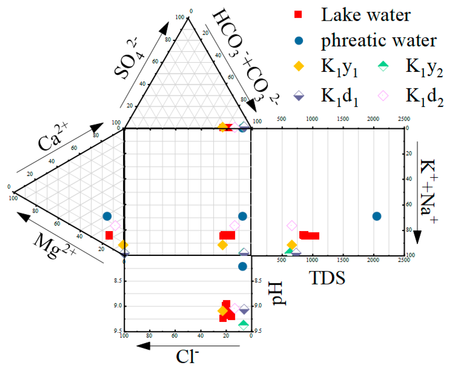
The Durov analysis of the major ionic hydrochemistry of each water sample shows that the anions in the lake and groundwater are biased towards HCO3− + CO32− end groups, the average proportion of major anions being 84%, and the HCO3− ion content of the lake water, phreatic water and confined water is 634.68 mg/L, 1080.41 mg/L and 478.86 mg/L, respectively. The cations are biased towards K+ + Na+ end members, the average proportion of major cations being 80%, and the Na+ ion content of the lake water, phreatic water and confined water is 246.62 mg/L, 255.07 mg/L and 191.05 mg/L, respectively. The lake water, phreatic water and confined water are of the HCO3−Na hydrochemical type (Figure 3).
For example, the average TDS content of the lake water is 947.50 mg/L and the coefficient of variation is 7.54%, which is due to the weakening of the water dynamics of the lake due to the existence of ice sheets, and the lake water has weak regional differences [34]. The average TDS content of confined water is about 666.00 mg/L and the coefficient of variation is about 5.72%, which is lower than that of lake water and phreatic water (2049.00 mg/L), which is about 70.29% and 32.50%, respectively. At the same time, the pH value of confined water (9.14) is similar to that of lake water (9.14), and both are higher than that of phreatic water (8.21).
The K1y1, K1y2 and K1d1 Cretaceous confined aquifers with shallow roof burial depths have similar data drop points in the Durov analysis, and their average content of major cations K+ + Na+ is about 207.12 mg/L, while their mean proportion of major cations is about 95%. The K1d2 confined aquifer, with the deepest roof burial depth (441 m), shows a great difference in its hydrochemical characteristics from the other Cretaceous confined aquifers. The content of major cations K++ Na+ in the K1d2 confined aquifer is 160.04 mg/L, and its proportion of major cations is 72%. The average content of major cations in the lake water and phreatic water is 264.88 mg/L and 262.70 mg/L, respectively, and their proportions of major cations are 78% and 61%, respectively. The content and proportion of major cations in K1d2 confined water are closer to those in lake water and phreatic water.
3.2. Stable Isotope Characteristics
Since precipitation is the initial input source of groundwater, it is of great significance to evaluate the isotopic characteristics of surface water and groundwater based on the atmospheric precipitation line. Firstly, based on the 2022 precipitation isotope of the Hulun Lake basin, a linear regression model was adopted to construct the atmospheric precipitation evaporation trend line (LMWL) for the analysis of the isotope characteristics [35]. The analysis of the δD and δ18O values of the water bodies in the basin (Figure 4) shows that δD ranges from −103.43‰ to −15.75‰ and δ18O ranges from −15.07‰ to −1.30‰. The mean values of δD and δ18O of atmospheric precipitation are −80.35‰ and −10.83‰; the LMWL is δD = 7.57*δ18O + 1.69 (R2 = 0.98).
The mean values of δD and δ18O in the lake are −69.23‰ and −7.56‰, and the coefficient of variation is 5.25% and 3.10%. The data dip is to the lower right of the LMWL, indicating that the lake is subject to strong evaporation, which is common in arid climates or closed basins [36]. Based on the isotopic characteristics of the lake water, a linear regression model was used to construct the evaporation trend line (EL, δD = 5.27*δ18O − 29.37, R2 = 0.99). The δD/δ18O slope (5.28) within the basin is lower than the global average (8.00), because the climate of Hulun Lake is dry and the air humidity is relatively low. The unbalanced fractionation in the evaporation process within the basin is caused by the existence of the lake and the objective fact that evaporation is much larger than precipitation, which further affects the local cloud formation rate [37].
The δD and δ18O content of groundwater is lower than that in lake water, the overall performance is in the order of “confined water<phreatic water< lake water”, and the δD and δ18O values of phreatic water are −82.00‰ and −10.30‰. The phreatic data’s landing point is located at the EL, indicating that there is a strong interaction between the phreatic water and lake water, which causes the spatial distribution of the stable isotope composition [38]. The δD and δ18O values of the four Cretaceous confined waters have little difference, and the coefficient of variation is 1.52% and 4.87%, respectively; the δD value ranges from −99.00‰ to −95.00‰, with a mean value of −97.25‰; and the δ18O value ranges from −13.50‰ to −11.90‰, with an average value of −12.78‰. The δD and δ18O values of the K1d2 confined water with the deepest roof burial depth (441 m) are −95.00‰ and −11.90‰, which are higher than those in the K1y1, K1y2 and K1d1 confined aquifers. The stable isotope values of δD and δ18O in K1d2 confined water are closest to the lake water and the phreatic water in the same region.
3.3. Renewal Rate and Age of Groundwater
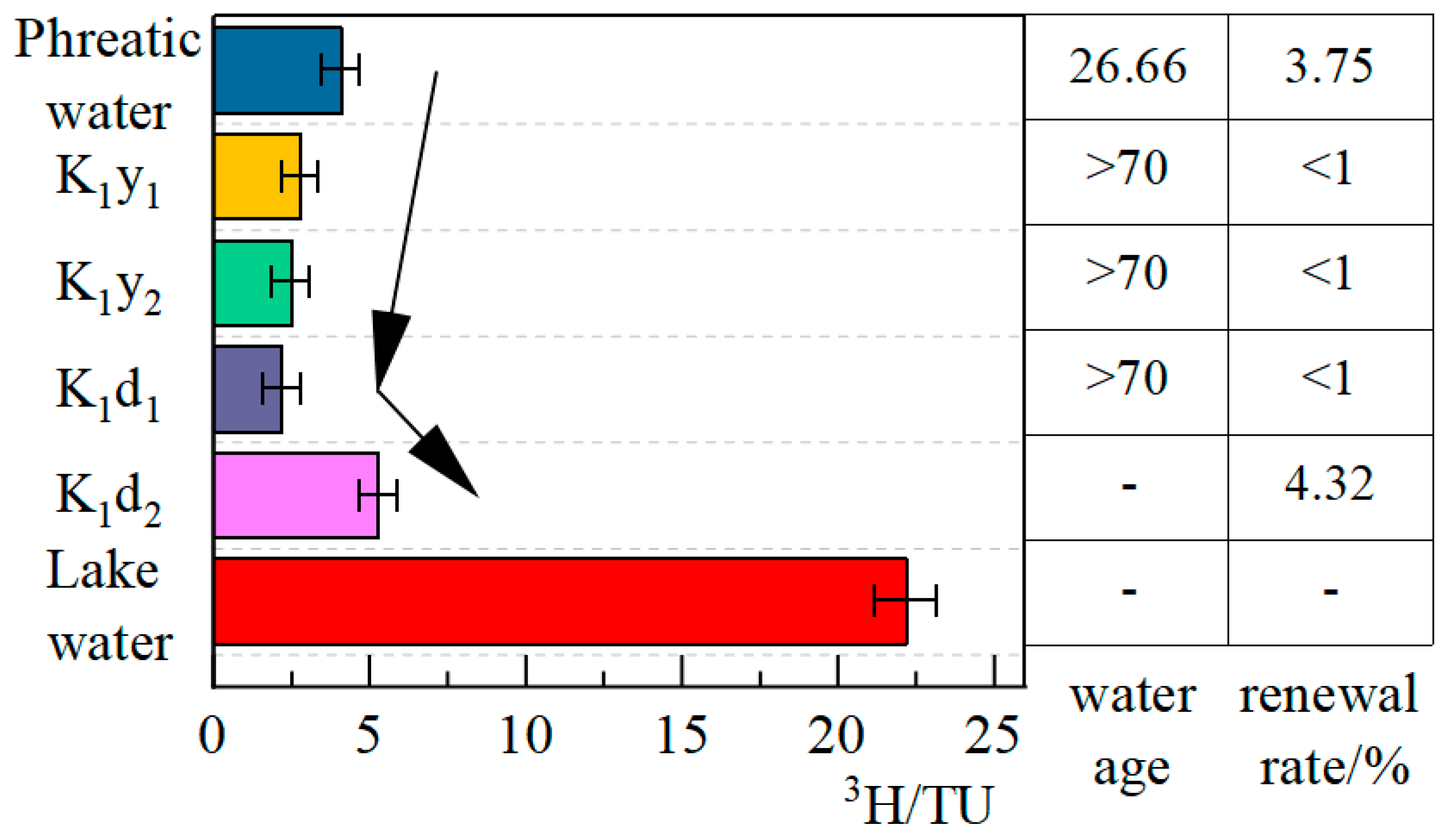
The δ3H concentration of the lake water in the basin is about 22.10 ± 1.00 TU, the coefficient of variation of the tritium content of the lake water in the spatial distribution is 0.23%, and the δ3H concentration of the water is 4.10 TU, which exceeds the modern water threshold of 4.00 TU, indicating that the water is modern water and the main supply source is atmospheric precipitation [39]. The phreatic age determined by the EMM model is 26.66a and the renewal rate is 3.75% (Figure 5).
The δ3H values of the K1y1, K1y2 and K1d1 confined aquifers are between 0.22 TU and 4.00 TU, indicating that the confined water is a mixture of modern and premodern water. As the burial depth of the confined aquifer roof increases, the δ3H concentration of the water decreases, and the recharge and renewal capacity of the confined aquifer gradually weakens with the increase in the aquifer roof burial depth, indicating that the older the formation period of the confined aquifer, the worse the water recharge and discharge conditions and the lower the water renewal capacity. The water renewal rate determined by the PFM model indicates that the water renewal capacity of the K1y1, K1y2 and K1d1 confined waters is less than 1%. The δ3H concentration of the K1d2 confined aquifer is 5.30 TU, which is far higher than the δ3H concentration of other Cretaceous strata confined aquifers. The water renewal rate is 4.32%, showing a large difference from other Cretaceous confined aquifers, indicating that the discharge condition of the K1d2 aquifer is poor and is affected by external water sources. Combined with the unique topography of the lake, the hydraulic exchange between the groundwater and phreatic water or lake water in the confined aquifer was analyzed through the tectonic fracture zone.
4. Discussion
4.1. Transformation Mechanism of Groundwater Ions
In order to investigate the hydrochemical evolution relationship between lake water and groundwater, we carried out a Gibbs analysis of the anions and cations in the lake water, phreatic water and confined water (Figure 6). The data drop points of the phreatic and confined water bodies in the Gibbs map are all outside the atmospheric precipitation region, indicating that the phreatic and confined waters are not directly caused by the recharge of precipitation and their ion composition is weakly affected by atmospheric precipitation. The main recharge sources of lake water are river water and groundwater, and the direct recharge of lake water by precipitation is not sufficient to play a role in the water–rock reaction [40]. During the ice cover period, the lake water showed little spatial variation and was mainly distributed in the area controlled by rock leaching and evaporative crystallization, indicating that the evaporation of the lake was much greater. Compared with lake water, groundwater is subjected to strong rock leaching, and the Na+/(Na++Ca2+) ratio of phreatic water is about 0.72, which is significantly lower than the average ratio of lake water at about 0.89. Meanwhile, the average ratio of confined water Cl−/(Cl−+HCO3−) is about 0.08, which is significantly lower than the average ratio of lake water at about 0.19. This is attributed to the ion exchange and absorption in the groundwater of lakes in cold and arid regions, which indicates that the water–rock interaction is the main controlling factor of the hydrochemical evolution of groundwater bodies [41].
The main influencing factors of water chemical evolution can be determined by the analysis of ion end-elements and the main ion relationships (Figure 7). The effects of dilution and evaporation on hydrochemistry can be measured by the ratio of Mg2+/Na+ to Ca2+/Na+. The main sources of ions in water can be divided into carbonate (i.e., calcite and dolomite) rocks, the chemical weathering of silicates (i.e., feldspar, Ca-plagioclase, and olivine) and evaporative dissolution (i.e., halite, gypsum) [42]. As can be seen from Figure 7a, silicate rock and evaporite are the main factors affecting the evolution of the water chemical composition in the lake water and groundwater, and the confined water is more strongly affected by evaporation dissolution than phreatic water. The Na+/Cl− ratio is often used to explain the dissolution of evaporite. It can be seen from Figure 7b that the ratio of Na+/Cl− in both lake water and groundwater is greater than 1, indicating that Cl− and Na+ are not entirely derived from rock salt dissolution. Other sodium-bearing minerals are also dissolved in the water in addition to rock salt, such as aluminosilicates. In addition, the Ca2+ in groundwater can also be exchanged with the Na+ in soil, making the water concentration of Na+ higher than that of Cl−.
The source of chemical weathering of carbonate rocks can be explained by the ratio of Na+/Ca2+ to Mg2+/Ca2+ [43], as shown in Figure 7c. A low ratio indicates that the main source of hydrochemical composition is the dissolution of calcite, while a high ratio indicates that the main source of hydrochemical composition is the dissolution of dolomite [44]. The chemical weathering of carbonate rocks is weak in the submersible and confined water of the basin, and the ratio of Na+/Ca2+ to Mg2+/Ca2+ in the K1y2 and K1d1 confined aquifers is much higher than the 1:1 line, which indicates that there is a small amount of dolomite weathering and dissolution with K1y2 and K1d1 confined water, while the ratio of phreatic water is low, very close to the 1:1 line, indicating that the hydrochemical composition of phreatic water is affected by a small amount of calcite.
The dissolution of carbonate and aluminosilicate minerals in groundwater systems is often expressed by the ratio of Ca2+ + Mg2+ to SO42−, as shown in Figure 7d. The ratio of phreatic water is less than 1, indicating that the chemical composition of phreatic water is mainly dissolved by aluminum silicate minerals, and the ratio of K1y2 to K1d1 confined aquifer water is equal to 1. This indicates that the dissolution of aluminum silicate minerals in the K1y2 and K1d1 aquifers plays a relatively weak role in the evolution of the hydrochemical components. The ratio of Ca2+ to Mg2+ and the ratio of Ca2+ + Mg2+ to Ca2+ + Mg2+ + Na+ + K+ are used to explain the influence of various minerals [45], as shown in Figure 7e,f. The ratio of Ca2+ to Mg2+ in confined water is greater than 1, indicating that the Cretaceous confined water is mainly affected by evaporite action, while the ratio of Ca2+ to Mg2+ in phreatic water is less than 1, indicating that the phreatic aquifer is affected by the dissolution of calcium plagioclase and olivine.
The analysis of the ion relationships indicates that the dissolution of feldspar minerals is the primary factor influencing the chemical evolution of phreatic water. In contrast, the chemical evolution of the K1y1, K1y2, and K1d1 confined aquifers is primarily influenced by evaporite action. Notably, the water–rock interaction of the K1d2 confined aquifer differs significantly from that of the K1y1, K1y2 and K1d1 aquifers, which are also Cretaceous strata. Although both the K1d1 and K1d2 aquifers belong to the Damaoguaihe Formation, there is only a 21m difference in the roof burial depth between them and the difference in rock properties is small. However, the K1d2 confined aquifer, with a deep roof burial depth at 441m, exhibits water–rock interaction properties similar to those found in phreatic aquifers. The Cuogang Fault and Xishan Fault, located on the eastern and western banks of Hulun Lake, are in line with the long axis of the lake, respectively. This, combined with the unique topographic structure of Hulun Lake, suggests a possible hydraulic connection between the K1d2 confined water and phreatic water.
4.2. Hydraulic Relation between Hulun Lake and Cretaceaous Confined Water
Confined water in groundwater recharge lake water plays a key role in the recharge of lake water, so it is necessary to clarify the recharge source of confined water in the lake. The hydrogeochemical analysis shows that the K1d2 confined aquifer has a hydraulic connection with the lake or a submersible aquifer. In order to further verify the results and analyze the means of hydraulic exchange between the confined water and surface water, the multi-source tracer method is used to comprehensively analyze the recharge location of the groundwater. In a groundwater system, the main ion hydrochemistry and stable isotope characteristics of a single water sample mainly reflect its water source mixing and flow path, and the groundwater age and renewal rate reflect the length and average flow velocity of the groundwater flow path [46,47].
There exists a replenishment relationship between the lake water and phreatic water in the Jalainur Depression Zone. There is a large area of island-like permafrost in the Hulunbuir area, and the island-like permafrost in the Jalainur Depression Zone is a marginal area. During the sampling period, the thickness of the frozen soil in this region was about 2 m [48]. Under the condition of frozen soil cover, the water level of the sampled phreatic point (564.35 m) was higher than that of the lake (545.07 m), confirming the phreatic water recharge of Hulun Lake in the Jalainur Depression Zone during the ice period, as observed by Han [49]. The cycling capacity of the K1y1, K1y2, K1d1 Cretaceous strata confined waters decreases with the increase in the aquifer roof burial depth, and their renewal rate is less than 1%. The hydrogeochemical and isotopic characteristics show that the Cretaceous aquifer is not affected by the Cuogang Fault and Xishan Fault, which were generated by crustal faults, and they are consistent with the confined water’s properties in Northern China [50].
A significant different was found between the K1d2 Cretaceous strata confined water and the K1y1, K1y2, K1d1 Cretaceous strata confined water in terms of the hydrochemical characteristics, hydrogen and oxygen isotope characteristics and tritium isotope characteristics. The K1d2 confined water has higher TDS content, different water–rock interactions, higher δ18O and δD values and a higher renewal rate than other Cretaceous confined waters, indicating that the K1d2 aquifer has a hydraulic connection with external water bodies such as phreatic water and lake water, which is consistent with the characteristics of confined water samples near faults [51]. The renewal rate of the K1d2 confined water is higher than that of phreatic water in the same region, which indicates that the confined water has hydraulic exchange with the lake water, and the deep confined water has hydraulic contact with the lake water through the fracture zone at the lake edge. This phenomenon is similar to the discontinuous permafrost in many mountainous areas of the Qinghai–Tibet Plateau [52]. The formation mechanism is as follows: Hulun Lake was formed under the influence of volcanic eruption and magmatic activity, and shrinkage cracks were generated during the cooling of volcanic lava, so that groundwater transported water in the basin for a long time through the channel of the middle crust or the upper mantle lithosphere [53]. At the end of the Cenozoic and the end of the Tertiary period, two NNE-trending large fault zones were generated in the present lake area under the continuous compression of the crust, and hydraulic exchange was generated between the groundwater and the lake through these two fault zones [54]. The hydraulic connection between the lake and the confined water explains the annual water imbalance in Hulun Lake.
5. Conclusions
This study reveals the interaction between lake water and groundwater in Hulun Lake through the analysis of main ions, δD, δ18O and δ3H, and other environmental tracers. The NNE-trending fault zone on both sides of Hulun Lake, in the same direction as the long axis of the lake, leads to hydraulic exchange between the lake water and the Cretaceous confined aquifer, resulting in drastic interannual variations in the lake water level. The study’s main conclusions are as follows.
- (1)
- The lake water, phreatic water and confined water are of the hydrochemical HCO3−Na type, and the stable isotope (δD, δ18O) and radioisotope (δ3H) content is in the order of “confined water < phreatic water < lake water”. The main factor influencing the hydrochemical evolution of the phreatic water is the dissolution of feldspar minerals. The age of the phreatic water is about 26.66 years and the water renewal rate is nearly 3.75%. The main influencing factor of the hydrochemical evolution in the K1y1, K1y2 and K1d1 Cretaceous confined water layers is the dissolution of evaporites (i.e., halite, gypsum), the water renewal rate is less than 1%, and the discharge condition of the groundwater deteriorates with the increase in the aquifer roof burial depth.
- (2)
- The K1d2 confined water of the Lower Cretaceous–Damoguaihe Formation II Coal Formation with the deepest roof burial depth (441 m) shows great differences in hydrochemistry and the δD, δ18O and δ3H indexes compared to the K1y1, K1y2 and K1d1 confined waters of the other Cretaceous strata in the same basin, and the water characteristics of the K1d2 aquifer are similar to those of the lake water and phreatic water. The renewal rate of the K1d2 confined water (4.32%) is better than that of the phreatic water. Under the condition of the presence of permafrost cover, the phreatic water in the Jalainur Depression Zone supplies Hulun lake. In addition, the Cuogang Fault and Xishan Fault, caused by crustal faults, resulted in the hydraulic relationship between the K1d2 confined water, lake water and phreatic water, resulting in drastic interannual changes in the lake water level.
- (3)
- This study has improved the understanding of the controlled circulation and hydrochemical evolution of the lake–groundwater system in cold and arid regions. However, a study of the interannual flow between the Cretaceous confined aquifer and the lake water has not yet been carried out. In addition, long-term groundwater level and discharge data are not available to further investigate the groundwater flow path. Therefore, long-term and large-scale studies of the groundwater cycle are recommended for the future.
Author Contributions
H.G.: conceptualization, investigation, methodology, writing—original draft, writing—review and editing. W.L.: formal analysis, project administration, writing—review and editing. S.Z.: formal analysis, project administration, writing—review and editing. Y.T.: writing—review and editing, formal analysis. X.G.: writing—review and editing, formal analysis. All authors have read and agreed to the published version of the manuscript.
Funding
This work was supported by the National Natural Science Foundation of China under contract No. 52160021 and 51669021, the Natural Science Foundation of Inner Mongolia under contract No. 2021MS05043, the Major Science and Technology Projects in Inner Mongolia Autonomous Region (2020GG0009), the National Basic Research Program of China under contract No. 2019YFC0409205, and the Program for Young Talents of Science and Technology in Universities of Inner Mongolia Autonomous Region No. NJYT-20-A14.
Data Availability Statement
The data that support the findings of this study are available from the corresponding author upon reasonable request.
Conflicts of Interest
The authors declare that they have no known competing financial interests or personal relationships that may appear to have influenced the work reported in this paper.
References
- Wang, J.; Song, C.; Reager, J.T.; Yao, F.; Famiglietti, J.S.; Sheng, Y.; MacDonald, G.M.; Brun, F.; Schmied, H.M.; Marston, R.A.; et al. Recent global decline in endorheic basin water storages. Nat. Geosci. 2018, 11, 926–932. [Google Scholar] [CrossRef]
- Busker, T.; de Roo, A.; Gelati, E.; Schwatke, C.; Adamovic, M.; Bisselink, B.; Pekel, J.-F.; Cottam, A. A global lake and reservoir volume analysis using a surface water dataset and satellite altimetry. Hydrol. Earth Syst. Sci. 2019, 23, 669–690. [Google Scholar] [CrossRef]
- Rodell, M.; Famiglietti, J.S.; Wiese, D.N.; Reager, J.T.; Beaudoing, H.K.; Landerer, F.W.; Lo, M.-H. Emerging trends in global freshwater availability. Nature 2018, 557, 651–659. [Google Scholar] [CrossRef]
- Zhao, G.; Li, Y.; Zhou, L.; Gao, H. Evaporative water loss of 1.42 million global lakes. Nat. Commun. 2022, 13, 3686. [Google Scholar] [CrossRef]
- Yao, F.; Ben, L.; Balaji, R.; Wang, J. Satellites reveal widespread decline in global lake water storage. Science 2023, 380, 743–749. [Google Scholar] [CrossRef]
- O’Reilly, C.M.; Sharma, S.; Gray, D.K.; Hampton, S.E. Rapid and highly variable warming of lake surface waters around the globe. Geophys. Res. Lett. 2015, 42, 10773–10781. [Google Scholar] [CrossRef]
- Sharma, S.; Blagrave, K.; Magnuson, J.J.; O’Reilly, C.M.; Oliver, S.; Batt, R.D.; Magee, M.R.; Straile, D.; Weyhenmeyer, G.A.; Winslow, L.; et al. Widespread loss of lake ice around the Northern Hemisphere in a warming world. Nat. Clim. Chang. 2019, 9, 227–231. [Google Scholar] [CrossRef]
- Lv, A.; Chuanhui, Z. Analysis of the characteristics and driving forces of changes in lake water volume in inland arid basins in China. Water 2022, 14, 3141. [Google Scholar] [CrossRef]
- Chen, J.; Wu, T.; Liu, L.; Gong, W.; Zwieback, S.; Zou, D.; Zhu, X.; Hu, G.; Du, E.; Wu, X.; et al. Increased water content in the active layer revealed by regional-scale Insar and independent component analysis on the central Qinghai-Tibet plateau. Geophys. Res. Lett. 2022, 49, 2125–2130. [Google Scholar] [CrossRef]
- Song, W.; A, Y.; Wang, Y.; Xue, B. Landsat satellite image-derived area evolution and the driving factors affecting Hulun lake from 1986 to 2020. Remote Sens. 2023, 15, 2682. [Google Scholar] [CrossRef]
- Liu, Y.; Yue, H. Estimating the fluctuation of Lake Hulun, China, during 1975–2015 from satellite altimetry data. Environ. Monit. Assess. 2017, 189, 630. [Google Scholar] [CrossRef]
- Li, C.; Wang, J.; Hu, R.; Yin, S.; Bao, Y.; Li, Y. ICESat/GLAS-derived changes in the water level of Hulun Lake, Inner Mongolia, from 2003 to 2009. Front. Earth Sci. 2018, 12, 420–430. [Google Scholar] [CrossRef]
- Li, C.; Leal, W.; Nagy, G.; Wang, J.; Ciani, A.; Sidsaph, H.; Fedoruk, M.; Yin, S.; Bao, Y.; Ayal, D. Satellite imagery evidence for a multiannual water level decline in Hulun Lake, China, with suggestions to future policy making responses. DIE ERDE-J. Geogr. Soc. Berl. 2019, 150, 31–39. [Google Scholar]
- Gao, H.; Ryan, M.; Li, C.; Sun, B. Understanding the role of groundwater in a remote transboundary lake (Hulun Lake, China). Water 2017, 9, 363. [Google Scholar] [CrossRef]
- Sun, B.; Yang, Z.; Zhao, S.; Shi, X.; Liu, Y.; Ji, G.; Huotari, J. Water balance analysis of Hulun lake, a semi-arid unesco wetland, using multi-source data. Remote Sens. 2023, 15, 2028. [Google Scholar] [CrossRef]
- Xia, S.; Liu, Z.; Liu, J.; Chang, Y.; Li, P.; Gao, N.; Ye, D.; Wu, G.; Yu, L.; Qu, L. The controlling factors of modern facies distributions in a half-graben lacustrine rift basin: A case study from Hulun Lake, Northeastern China. Geol. J. 2018, 53, 977–991. [Google Scholar] [CrossRef]
- Cao, Y.; Fu, C.; Wang, X.; Dong, L.; Yao, S.; Xue, B.; Wu, H.; Wu, H. Decoding the dramatic hundred-year water level variations of a typical great lake in semi-arid region of northeastern Asia. Sci. Total Environ. 2021, 770, 145353. [Google Scholar] [CrossRef]
- Wang, W.; Li, W.; Xue, M.; Gu, X. Spatial-temporal characteristics and influencing factors of lake water and groundwater chemistry in Hulun lake, Northeast China. Water 2023, 15, 937. [Google Scholar] [CrossRef]
- Mao, P.; Zhang, J.; Li, M.; Liu, Y.; Wang, X.; Yan, R.; Shen, B.; Zhang, X.; Shen, J.; Zhu, X.; et al. Spatial and temporal variations in fractional vegetation cover and its driving factors in the Hulun Lake region. Ecol. Indic. 2022, 135, 108490. [Google Scholar] [CrossRef]
- Wu, T.; Li, J.; Song, J. Geological features and tectonic evolution in Hulun Lake. Nat. Herit. 2020, 5, 13–26. [Google Scholar]
- DZ/T 0064.78-2021; Methods for Analysis of Groundwater Quality—Part 78: Determination of Deuterium—Reduction Method of Metal Zinc—Gas Isotope Ratio Mass Spectrometry. Ministry of Natural Resources of the People’s Republic of China; National Technical Committee for Standardization of Natural Resources and Territorial Space Planning, 2021.
- DZ/T 0064.79-2021; Methods for Analysis of Groundwater Quality—Part 79: Determination of Tritium—Radiochemical Method. Ministry of Natural Resources of the People’s Republic of China; National Technical Committee for Standardization of Natural Resources and Territorial Space Planning, 2021.
- GB/T 5750.3-2023; Standard Examination Methods for Drinking Water—Part 3: Water Analysis Quality Control. State Administration for Market Regulation; National Standardization Administration; National Health Commission, 2023.
- László, E.; Palcsu, L.; Leelőssy, Á. Estimation of the solar-induced natural variability of the tritium concentration of precipitation in the Northern and Southern Hemisphere. Atmos. Environ. 2020, 233, 117605. [Google Scholar] [CrossRef]
- Yang, P.; Ye, S. Global model of the annual mean concentration of Tritium in precipitation, 1960–2014. Acta Sci. Circumst. 2018, 38, 1759–1767. [Google Scholar]
- Liangju, Z.; Yunfeng, R.; Honglang, X.; Maoxian, Z. Application of radioactive trituium isotope in studying water cycle of the heihe river basin. Quat. Sci. 2014, 34, 959–972. [Google Scholar]
- Zhang, Y.; Ye, S.; Wu, J. A global model of recovering the annual mean tritium concentration in atmospheric precipitation. Geol. Rev. 2011, 57, 409–418. [Google Scholar]
- Hagedorn, B.; Clarke, N.; Ruane, M.; Faulkner, K. Assessing aquifer vulnerability from lumped parameter modeling of modern water proportions in groundwater mixtures: Application to California’s South Coast Range. Sci. Total Environ. 2018, 624, 1550–1560. [Google Scholar] [CrossRef]
- Ramaroson, V.; Rakotomalala, C.U.; Rajaobelison, J.; Fareze, L.P.; Razafitsalama, F.A.; Rasolofonirina, M. Tritium as tracer of groundwater pollution extension: Case study of Andralanitra landfill site, Antananarivo–Madagascar. Appl. Water Sci. 2018, 8, 1–8. [Google Scholar] [CrossRef]
- Telloli, C.; Rizzo, A.; Salvi, S.; Pozzobon, A.; Marrocchino, E.; Vaccaro, C.; Vaccaro, C. Characterization of groundwater recharge through tritium measurements. Adv. Geosci. 2022, 57, 21–36. [Google Scholar] [CrossRef]
- Jurgens, B.C.; Böhlke, J.K.; Kauffman, L.J.; Belitz, K.; Esser, B.K. A partial exponential lumped parameter model to evaluate groundwater age distributions and nitrate trends in long-screened wells. J. Hydrol. 2016, 543, 109–126. [Google Scholar] [CrossRef]
- Miao, J. Formation of the shallow groundwater in the Northern Henan Plain based on isotope ananlyses. Hydrogeol. Eng. Geol. 2010, 37, 5–11. [Google Scholar]
- Markovich, K.H.; Condon, L.E.; Carroll, K.C.; Purtschert, R.; McIntosh, J.C. A mountain-front recharge component characterization approach combining groundwater age distributions, Noble Gas Thermometry, and fluid and energy transport modeling. Water Resour. Res. 2021, 57, e2020WR027743. [Google Scholar] [CrossRef]
- Yu, T.; Zhang, Y.; Wu, F.; Meng, W. Six-decade change in water chemistry of large freshwater lake Taihu, China. Environ. Sci. Technol. 2013, 47, 9093–9101. [Google Scholar]
- Wallace, H.; Wexler, E.J.; Malott, S.; Robinson, C.E. Evaluating lacustrine groundwater discharge to a large glacial lake using regional scale radon-222 surveys and groundwater modelling. Hydrol. Process. 2021, 35, 14165. [Google Scholar] [CrossRef]
- Liao, F.; Wang, G.; Shi, Z.; Cheng, G.; Kong, Q.; Mu, W.; Guo, L. Estimation of groundwater discharge and associated chemical fluxes into Poyang Lake, China: Approaches using stable isotopes (δD and δ18O) and radon. Hydrogeol. J. 2018, 26, 1625–1638. [Google Scholar] [CrossRef]
- Han, Z.; Shi, X.; Jia, K.; Sun, B.; Zhao, S.; Fu, C. Determining the discharge and recharge relationships between lake and groundwater in lake Hulun using hydrogen and oxygen isotopes and chloride ions. Water 2019, 11, 264. [Google Scholar] [CrossRef]
- Yang, K.; Han, G. Controls over hydrogen and oxygen isotopes of surface water and groundwater in the Mun River catchment, northeast Thailand: Implications for the water cycle. Hydrogeol. J. 2020, 28, 1021–1036. [Google Scholar] [CrossRef]
- Zhang, Y.; Ye, S.; Wu, J. A modified global model for predicting the tritium distribution in precipitation, 1960-2005. Hydrol. Process. 2011, 25, 2379–2392. [Google Scholar] [CrossRef]
- Wu, R.; Zhang, S.; Liu, Y.; Shi, X.; Zhao, S.; Kang, X.; Quan, D.; Sun, B.; Arvola, L.; Li, G. Spatiotemporal variation in water quality and identification and quantification of areas sensitive to water quality in Hulun lake, China. Ecol. Indic. 2023, 149, 110176. [Google Scholar] [CrossRef]
- Liu, F.; Zou, J.; Liu, J.; Zhang, J.; Zhen, P. Factors controlling groundwater chemical evolution with the impact of reduced exploitation. Catena 2022, 214, 106261. [Google Scholar] [CrossRef]
- Li, Z.-J.; Li, Z.-X.; Fan, X.-J.; Wang, Y.; Song, L.-L.; Gui, J.; Xue, J.; Zhang, B.-J.; Gao, W.-D. Transformation mechanism of ions on different waters in alpine region. Chemosphere 2020, 248, 126082. [Google Scholar] [CrossRef]
- Li, Z.; Li, Z.; Feng, Q.; Zhang, B.; Gui, J.; Xue, J.; Gao, W. Runoff dominated by supra-permafrost water in the source region of the Yangtze river using environmental isotopes. J. Hydrol. 2020, 582, 124506. [Google Scholar] [CrossRef]
- Huang, X.; Ping, J.; Leng, W.; Yu, Y.; Zhang, M.; Zhu, Y. A study on groundwater recharge in the Anyanghe River alluvial fan, North China Plain, based on hydrochemistry, stable isotopes and tritium. Hydrogeol. J. 2021, 29, 2149–2170. [Google Scholar] [CrossRef]
- Liu, W.; Li, Z.; Song, L. The evolution of hydrochemistry at a cold alpine basin in the Qilian Mountains. Arab. J. Geosci. 2016, 9, 301. [Google Scholar]
- Kpegli, K.A.R.; Alassane, A.; Van der Zee, S.E.A.T.M. Development of a conceptual groundwater flow model using a combined hydrogeological, hydrochemical and isotopic approach: A case study from southern Benin. J. Hydrol.-Reg. Stud. 2018, 18, 50–67. [Google Scholar] [CrossRef]
- Moran, B.J.; Boutt, D.F.; Munk, L.A. Stable and radioisotope systematics reveal fossil water as fundamental characteristic of arid orogenic-scale groundwater systems. Water Resour. Res. 2019, 55, 11295–11315. [Google Scholar] [CrossRef]
- Chang, J.; Ye, R.; Wang, G. Review: Progress in permafrost hydrogeology in China. Hydrogeol. J. 2018, 26, 1387–1399. [Google Scholar] [CrossRef]
- Han, Z. Study on Hydrogen and Oxygen Isotope and Hydrochemistry Characteristics of Hulun Lake Basin. Ph.D. Thesis, Inner Mongolia Agricultural University, Hohhot, China, 2018. [Google Scholar]
- Niu, Y.; Weng, B.; Gong, X. Research process of groundwater in Qinghai-Tibet Plateau. IOP Con. Ser. Earth Environ. Sci. 2021, 705, 012031. [Google Scholar] [CrossRef]
- Gong, X.; Weng, B.; Yan, D.; Yang, Y.; Yan, D.; Niu, Y.; Wang, H. Potential recharge sources and origin of solutes in groundwater in the central Qinghai–Tibet Plateau using hydrochemistry and isotopic data. J. Hydrol.-Reg. Stud. 2022, 40, 101001. [Google Scholar] [CrossRef]
- Liu, Z.; Fang, Y.; Hu, H.; Wang, W. Variation and reason analysis of groundwater hydrochemical characteristics in Beiluhe Basin, Qinghai–Tibet Plateau during a freezing–thawing period. J. Water Clim. Chang. 2022, 13, 2799–2816. [Google Scholar] [CrossRef]
- Wu, S.; Sun, Y. Analysis of surface and groundwater changes of the Hulun Lake based on multisource data. Remote Sens. Technol. Appl. 2021, 36, 155–164. [Google Scholar]
- He, J. Formation and change of Hulun Lake. Inner. Mong. For. 2022, 39–41. [Google Scholar]
Figure 1.
Geographical location and aquifer distribution of Hulun Lake.

Figure 2.
Tritium concentration time series reconstruction during precipitation in Hulun Lake.

Figure 3.
Durov diagram for various water bodies.

Figure 4.
Plots of δ18O and δD for various water bodies.

Figure 5.
Water renewal capacity.

Figure 6.
Gibbs-type diagram of TDS versus rations.

Figure 7.
Ratios of major ions in various water bodies: (a) Mg2+/Na+ to Ca2+/Na+, (b) (Ca2++Mg2+)/(Na++K+) to Cl−/Na+, (c) Na+/Ca2+ to Mg2+/Ca+, (d) n(Ca2++Mg2+) to n(HCO3−+ SO42−), (e) n(Ca2+) to n(Mg2+), (f) n(Ca2++Mg2+) to n(Na++K+).
Figure 7.
Ratios of major ions in various water bodies: (a) Mg2+/Na+ to Ca2+/Na+, (b) (Ca2++Mg2+)/(Na++K+) to Cl−/Na+, (c) Na+/Ca2+ to Mg2+/Ca+, (d) n(Ca2++Mg2+) to n(HCO3−+ SO42−), (e) n(Ca2+) to n(Mg2+), (f) n(Ca2++Mg2+) to n(Na++K+).

Disclaimer/Publisher’s Note: The statements, opinions and data contained in all publications are solely those of the individual author(s) and contributor(s) and not of MDPI and/or the editor(s). MDPI and/or the editor(s) disclaim responsibility for any injury to people or property resulting from any ideas, methods, instructions or products referred to in the content. |
© 2024 by the authors. Licensee MDPI, Basel, Switzerland. This article is an open access article distributed under the terms and conditions of the Creative Commons Attribution (CC BY) license (https://creativecommons.org/licenses/by/4.0/).
Share and Cite
MDPI and ACS Style
Gao, H.; Li, W.; Zhang, S.; Tao, Y.; Guo, X. Hydraulic Relationship between Hulun Lake and Cretaceous Confined Aquifer Using Hydrochemistry and Isotopic Data. Sustainability 2024, 16, 2128. https://doi.org/10.3390/su16052128
AMA Style
Gao H, Li W, Zhang S, Tao Y, Guo X. Hydraulic Relationship between Hulun Lake and Cretaceous Confined Aquifer Using Hydrochemistry and Isotopic Data. Sustainability. 2024; 16(5):2128. https://doi.org/10.3390/su16052128
Chicago/Turabian StyleGao, Hengshuai, Wenbao Li, Sheng Zhang, Yulong Tao, and Xin Guo. 2024. "Hydraulic Relationship between Hulun Lake and Cretaceous Confined Aquifer Using Hydrochemistry and Isotopic Data" Sustainability 16, no. 5: 2128. https://doi.org/10.3390/su16052128
Note that from the first issue of 2016, this journal uses article numbers instead of page numbers. See further details here.