

Impact of Structural and Non-Structural Measures on the Risk of Flash Floods in Arid and Semi-Arid Regions: A Case Study of the Gash River, Kassala, Eastern Sudan


Abstract
:
1. Introduction
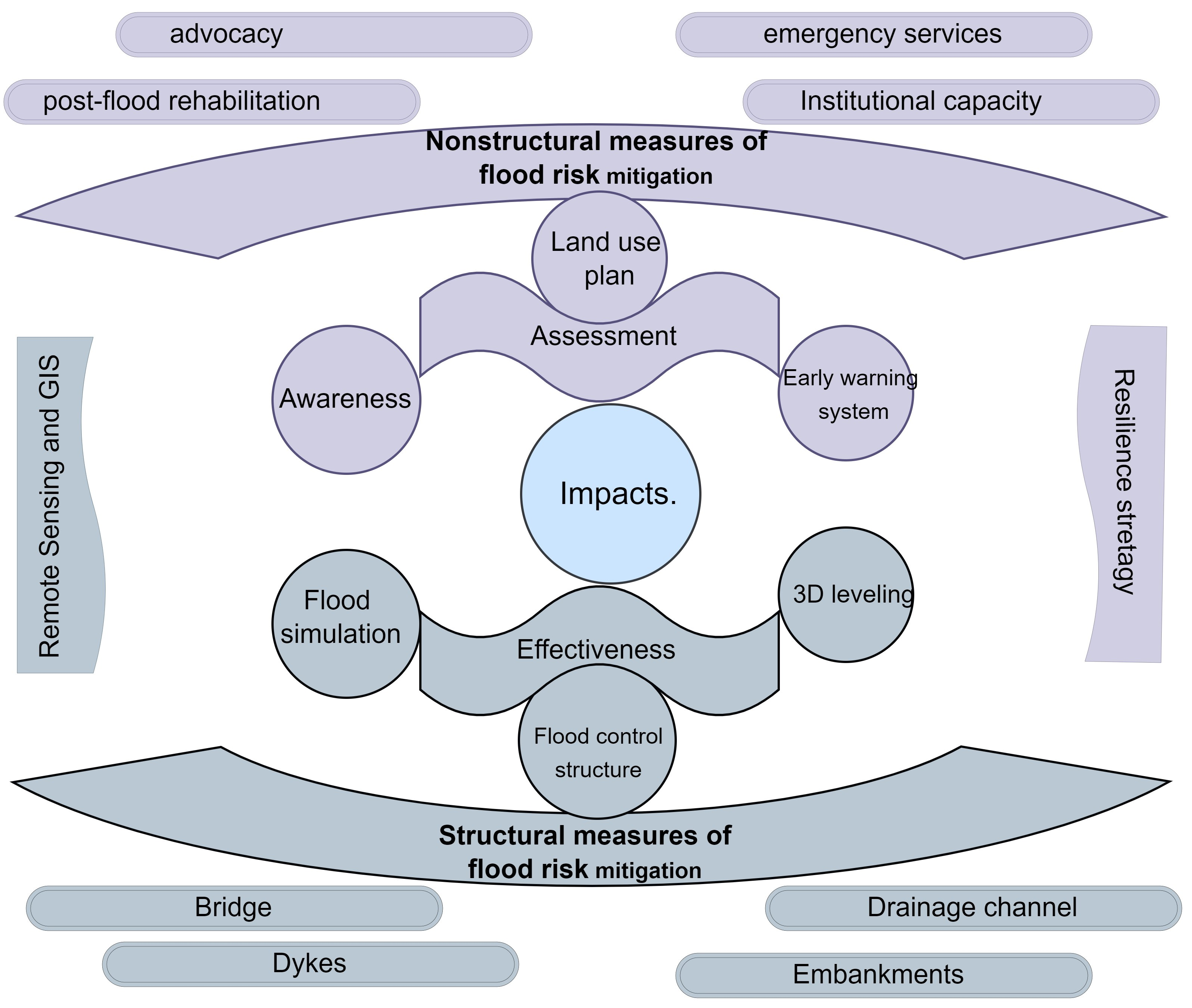
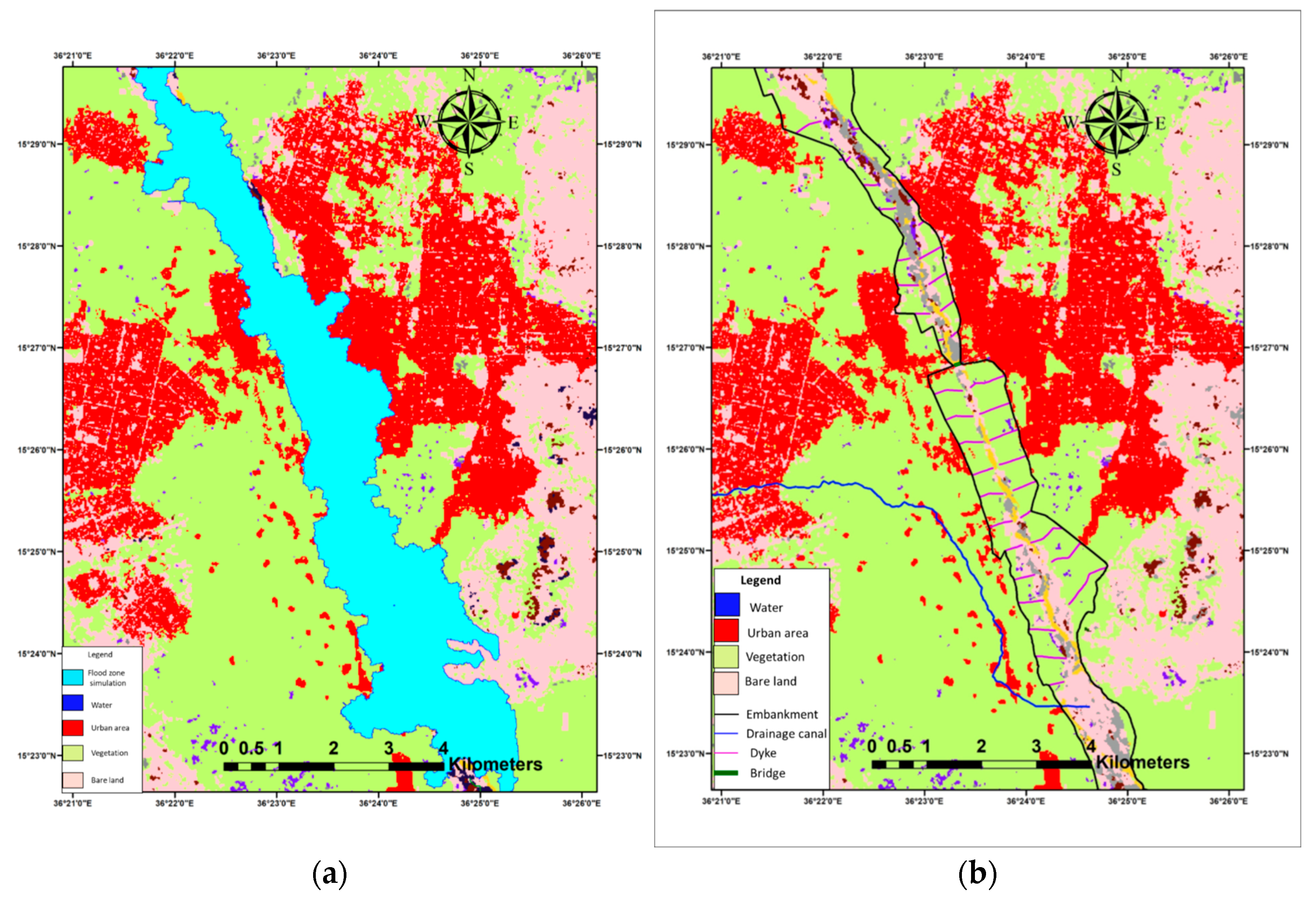
2. Study Area
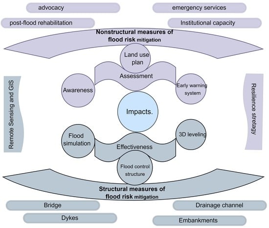
2.1. The Structural Measures and Non-Structural Flood Protection Measures
2.2. The Importance of the Gash River on Land Use Domain
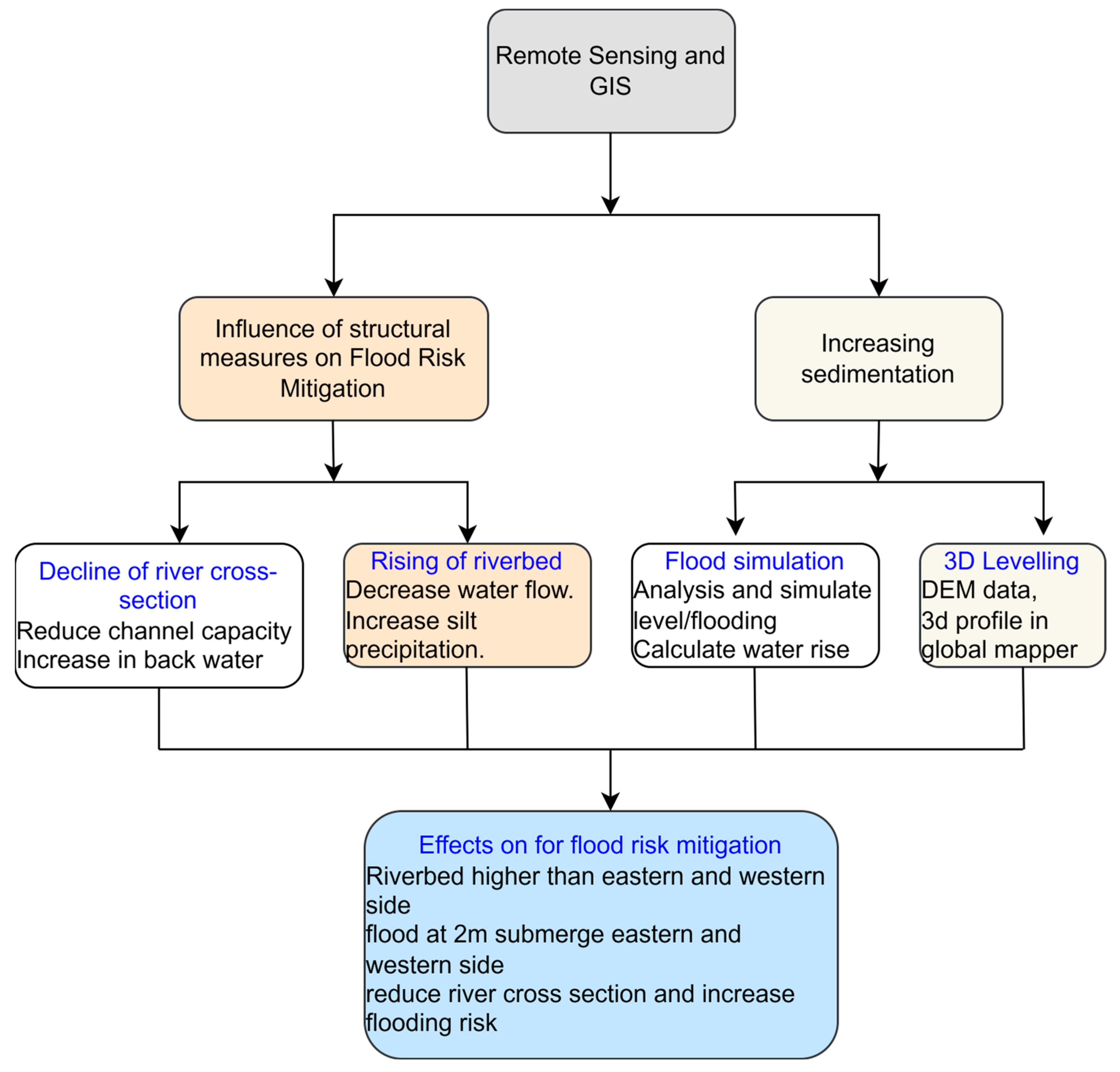
3. Materials and Methods
3.1. Data Collection Processing Method
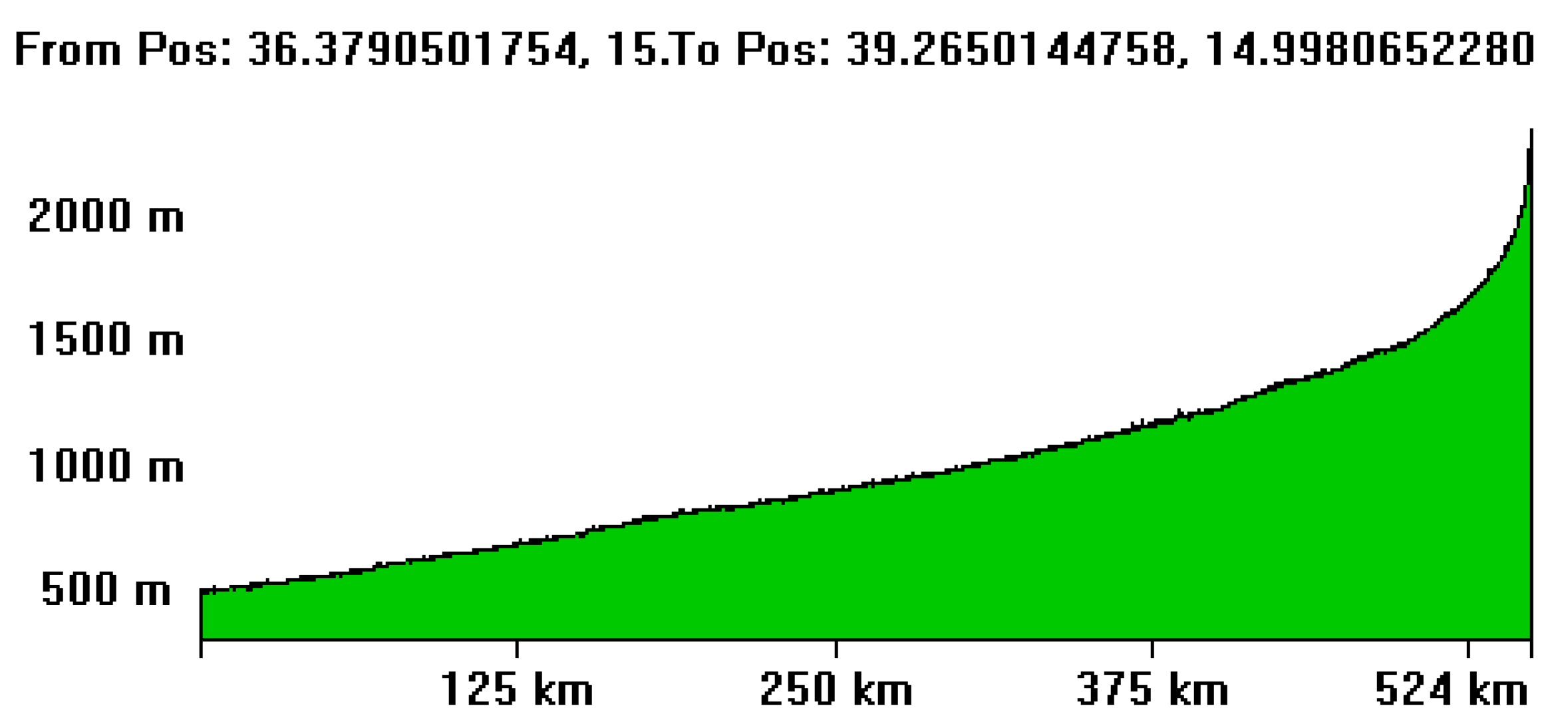
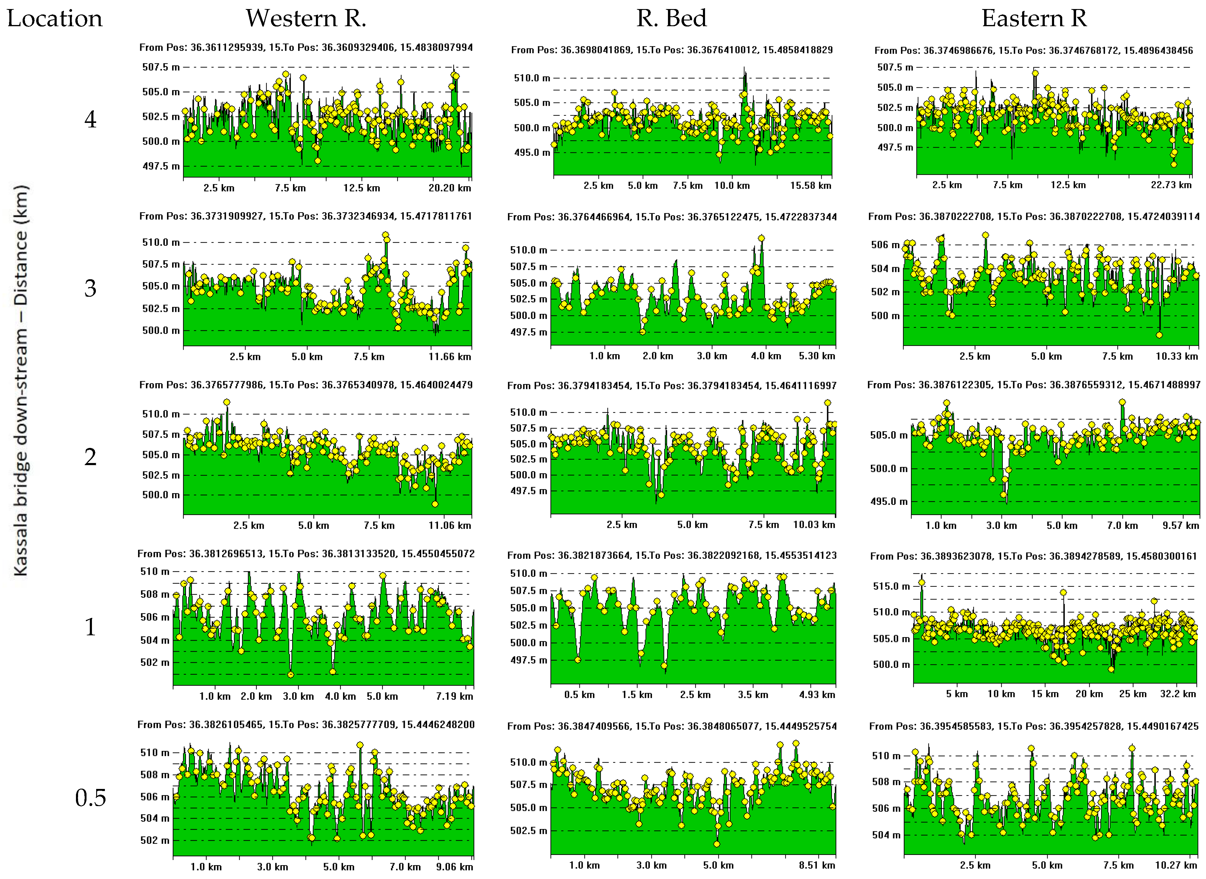
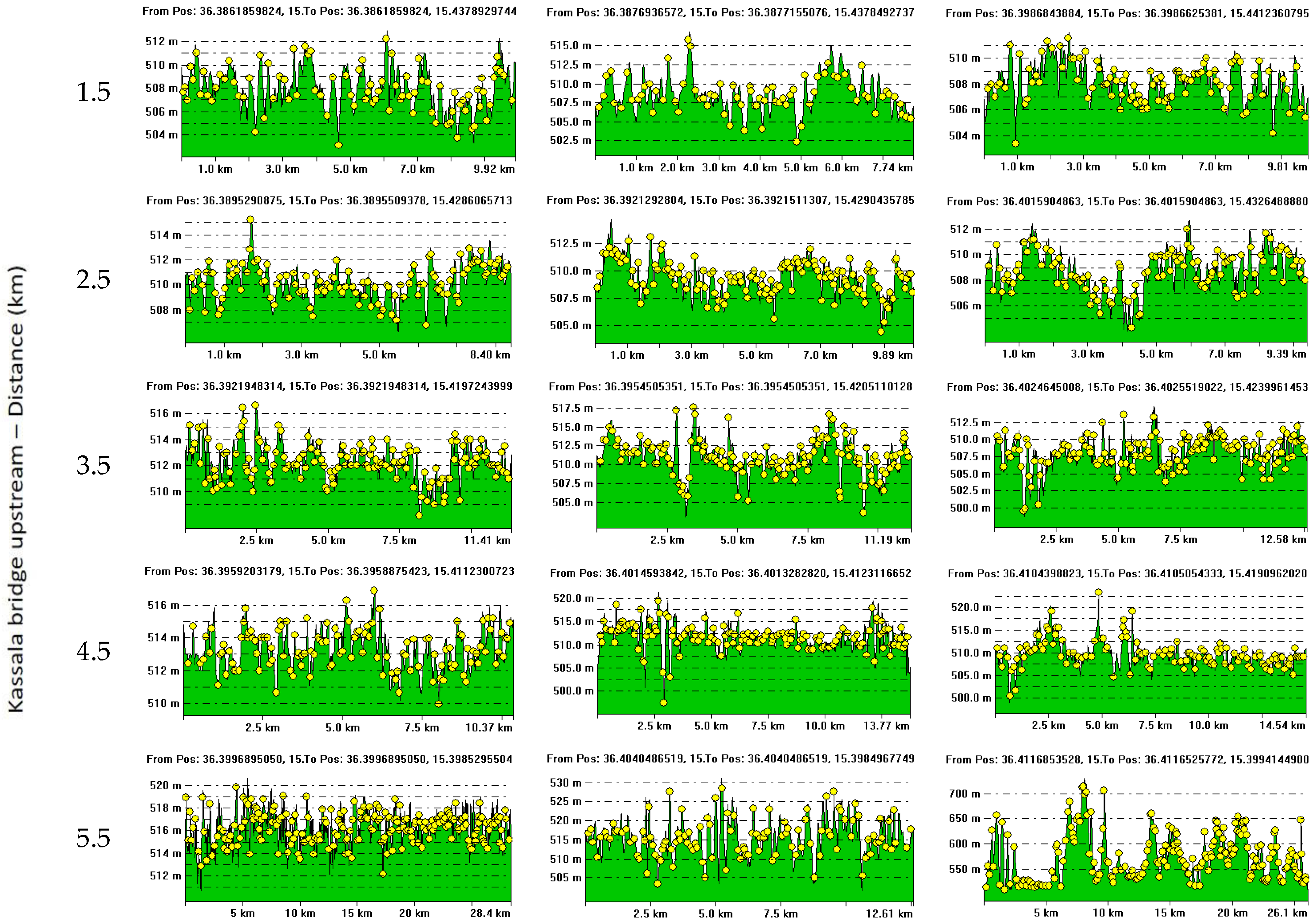
3.2. Elevation Points Measurement of the Gash River
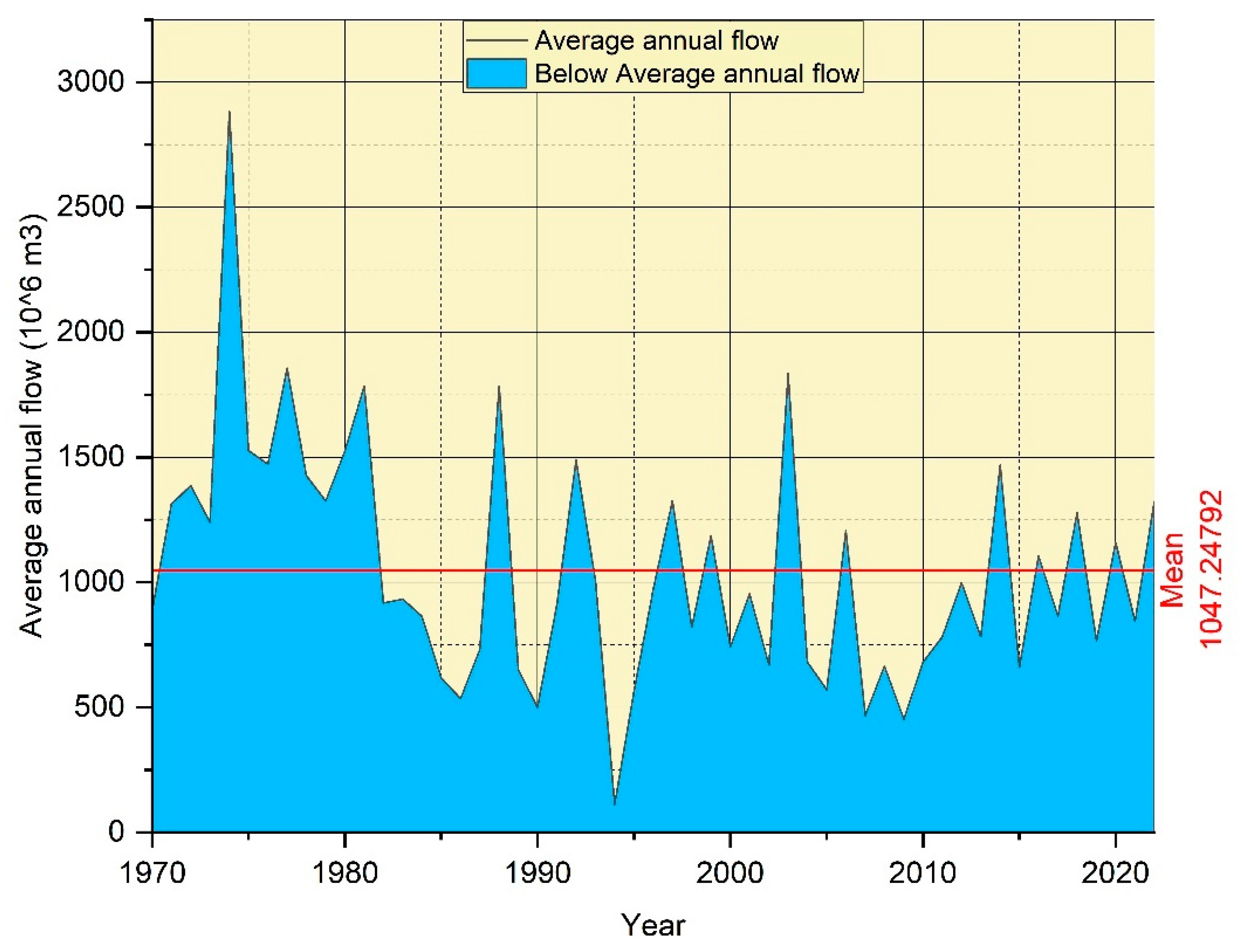
3.3. Gash River Flood Analysis
3.4. The Study Outline
4. Results and Discussion
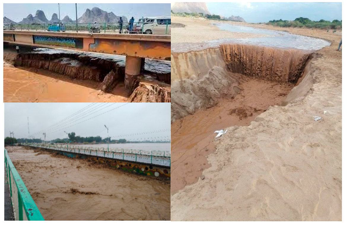
4.1. The Effect of Gash River Morphology, Climate Change, and the Catchment Area on Sediment Transport

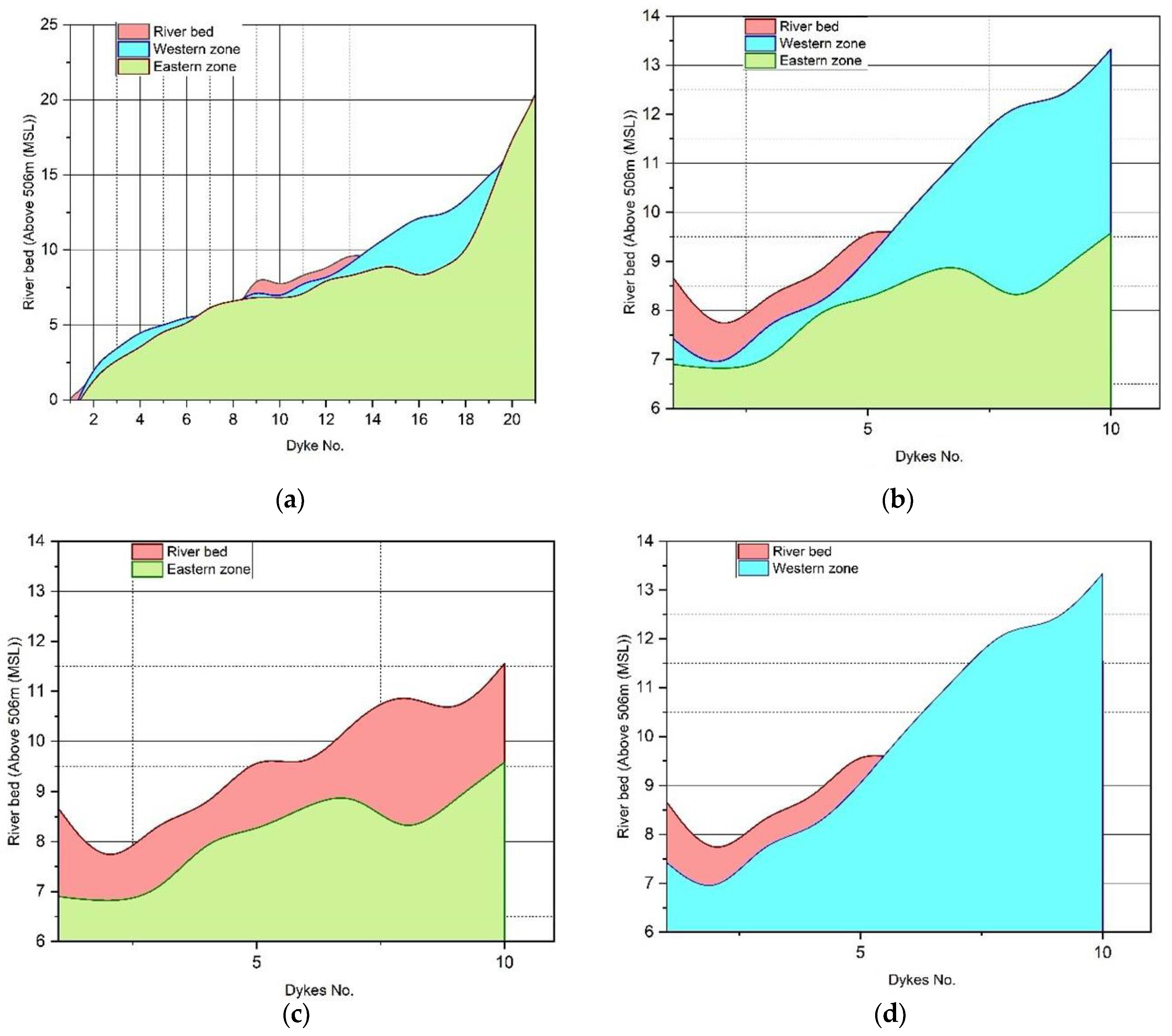
| Dike No | Contrast of Western Side with Riverbed Level | Contrast of Eastern Side with Riverbed | Flood Control Structures | |||||
|---|---|---|---|---|---|---|---|---|
| Rb | W. Level | ∆(Rb-W) | Rb | E. Level | ∆(Rb-E) | Rb | ||
| 1 | 0.11 | −1.19 | −1.08 |  | −1.09 | −0.98 | | Northern area of Kassala city—six spurs/dikes |
| 2 | 1.45 | 2.37 | −0.92 | 1.52 | −0.07 | |||
| 3 | 3.57 | 3.4 | 0.17 | 2.7 | 0.87 | |||
| 4 | 3.08 | 4.59 | −1.51 | 3.46 | −0.38 | |||
| 5 | 3.94 | 4.96 | −1.02 | 4.68 | −0.74 | |||
| 6 | 4.46 | 5.56 | −1.1 | 4.96 | −0.5 | |||
| 7 | 4.84 | 5.64 | −0.8 | 6.3 | −1.46 | |||
| 8 | 5.22 | 6.28 | −1.06 | 6.57 | −1.35 | |||
| 9 | 8.66 | 7.42 | 1.24 |  | 6.9 | 1.76 | | Adjacent Kassala city area —22 spurs and a dam were constructed |
| 10 | 7.34 | 6.63 | 0.71 | 6.78 | 0.56 | |||
| 11 | 8.45 | 7.9 | 0.55 | 6.91 | 1.54 | |||
| 12 | 8.63 | 8.03 | 0.6 | 8.1 | 0.53 | |||
| 13 | 9.84 | 9.02 | 0.82 | 8.2 | 1.64 | |||
| 14 | 9.36 | 10.22 | −0.86 | | 8.73 | 0.63 | ||
| 15 | 10.48 | 11.23 | −0.75 | 9.04 | 1.44 | |||
| 16 | 11.07 | 12.3 | −1.23 | 8.02 | 3.05 | |||
| 17 | 10.4 | 12.21 | −1.81 | 8.85 | 1.55 | |||
| 18 | 11.55 | 13.33 | −1.78 | 9.58 | 1.97 | |||
| 19 | 12.57 | 14.98 | −2.41 | 13.27 | −0.7 | | Southern Kassala—four spurs/dikes | |
| 20 | 15.72 | 16.27 | −0.55 | 17.65 | −1.93 | |||
| 21 | 18.72 | 20.11 | −1.39 | 19.92 | −1.2 | |||
| 22 | 24.09 | 24.88 | −0.79 | 25.22 | −1.13 | |||
| 23 | 29.6 | 32.43 | −2.83 | 33.39 | −3.79 | |||
| 24 | 39.98 | 41.44 | −1.46 | 42.05 | −2.07 | |||
4.2. Structural Measures Outcomes and Effectiveness Analysis
4.3. Analysis of Flood Hazard within the Prone Area
4.4. The Elevation Layer Variance of the Riverbed: Western and Eastern Bank
4.5. Non-Structural Measures and the Sustainability of the Gash River Basin
5. Conclusions and Recommendations
Author Contributions
Funding
Institutional Review Board Statement
Informed Consent Statement
Data Availability Statement
Acknowledgments
Conflicts of Interest
References
- Verma, S.; Sharma, A.; Yadava, P.K.; Gupta, P.; Singh, J.; Payra, S. Rapid Flash Flood Calamity in Chamoli, Uttarakhand Region during Feb 2021: An Analysis Based on Satellite Data. Nat. Hazards 2022, 112, 1379–1393. [Google Scholar] [CrossRef]
- Shah, A.A.; Gong, Z.; Pal, I.; Sun, R.; Ullah, W.; Wani, G.F. Disaster Risk Management Insight on School Emergency Preparedness–a Case Study of Khyber Pakhtunkhwa, Pakistan. Int. J. Disaster Risk Reduct. 2020, 51, 101805. [Google Scholar] [CrossRef]
- AL-Falahi, A.H.; Barry, S.; Gebrechorkos, S.H.; Spank, U.; Bernhofer, C. Potential of Traditional Adaptation Measures in Mitigating the Impact of Climate Change. Sustainability 2023, 15, 15442. [Google Scholar] [CrossRef]
- Zia, A.; Rana, I.A.; Arshad, H.S.H.; Khalid, Z.; Nawaz, A. Monsoon Flood Risks in Urban Areas of Pakistan: A Way Forward for Risk Reduction and Adaptation Planning. J. Environ. Manag. 2023, 336, 117652. [Google Scholar] [CrossRef] [PubMed]
- Barbaro, G.; Miguez, M.G.; de Sousa, M.M.; Ribeiro da Cruz Franco, A.B.; de Magalhães, P.M.C.; Foti, G.; Valadão, M.R.; Occhiuto, I. Innovations in Best Practices: Approaches to Managing Urban Areas and Reducing Flood Risk in Reggio Calabria (Italy). Sustainability 2021, 13, 3463. [Google Scholar] [CrossRef]
- Baudoin, L.; Gittins, J.R. The Ecological Outcomes of Collaborative Governance in Large River Basins: Who Is in the Room and Does It Matter? J. Environ. Manag. 2021, 281, 111836. [Google Scholar] [CrossRef] [PubMed]
- Yang, S.-C.; Yang, T.-H.; Chang, Y.-C.; Chen, C.-H.; Lin, M.-Y.; Ho, J.-Y.; Lee, K.T. Development of a Hydrological Ensemble Prediction System to Assist with Decision-Making for Floods during Typhoons. Sustainability 2020, 12, 4258. [Google Scholar] [CrossRef]
- Alam, M.K.; Dasgupta, S.; Barua, A.; Ravindranath, N. Assessing Climate-Relevant Vulnerability of the Indian Himalayan Region (IHR): A District-Level Analysis. Nat. Hazards 2022, 112, 1395–1421. [Google Scholar] [CrossRef]
- Baloch, W.L.; Siad, H.; Lachemi, M.; Sahmaran, M. A Review on the Durability of Concrete-to-Concrete Bond in Recent Rehabilitated Structures. J. Build. Eng. 2021, 44, 103315. [Google Scholar] [CrossRef]
- Luo, P.; He, B.; Takara, K.; Xiong, Y.E.; Nover, D.; Duan, W.; Fukushi, K. Historical Assessment of Chinese and Japanese Flood Management Policies and Implications for Managing Future Floods. Environ. Sci. Policy 2015, 48, 265–277. [Google Scholar] [CrossRef]
- Jiazhu, W. Three Gorges Project: The Largest Water Conservancy Project in the World. Public Adm. Dev. Int. J. Manag. Res. Pract. 2002, 22, 369–375. [Google Scholar] [CrossRef]
- Luo, H.; Oberg, N.; Landry, B.J.; García, M.H. Assessing the System Performance of an Evolving and Integrated Urban Drainage System to Control Combined Sewer Overflows Using a Multiple-Layer Based Coupled Modeling Approach. J. Hydrol. 2021, 603, 127130. [Google Scholar] [CrossRef]
- Magadza, C.H. Climate Change Impacts and Human Settlements in Africa: Prospects for Adaptation. Environ. Monit. Assess. 2000, 61, 193–205. [Google Scholar] [CrossRef]
- Obi, R.; Nwachukwu, M.U.; Okeke, D.C.; Jiburum, U. Indigenous Flood Control and Management Knowledge and Flood Disaster Risk Reduction in Nigeria’s Coastal Communities: An Empirical Analysis. Int. J. Disaster Risk Reduct. 2021, 55, 102079. [Google Scholar] [CrossRef]
- Ayeb-Karlsson, S.; Van der Geest, K.; Ahmed, I.; Huq, S.; Warner, K. A People-Centred Perspective on Climate Change, Environmental Stress, and Livelihood Resilience in Bangladesh. Sustain. Sci. 2016, 11, 679–694. [Google Scholar] [CrossRef] [PubMed]
- Glago, F.J. Flood Disaster Hazards; Causes, Impacts and Management: A State-of-the-Art Review. In Natural Hazards-Impacts, Adjustments and Resilience; IntechOpen Limited: London, UK, 2021; pp. 29–37. [Google Scholar]
- Fadul, E.; Masih, I.; De Fraiture, C. Adaptation Strategies to Cope with Low, High and Untimely Floods: Lessons from the Gash Spate Irrigation System, Sudan. Agric. Water Manag. 2019, 217, 212–225. [Google Scholar] [CrossRef]
- Peñarrocha, D.; Estrela, M.J.; Millán, M. Classification of Daily Rainfall Patterns in a Mediterranean Area with Extreme Intensity Levels: The Valencia Region. Int. J. Climatol. A J. R. Meteorol. Soc. 2002, 22, 677–695. [Google Scholar] [CrossRef]
- Verstraeten, G.; Poesen, J. Estimating Trap Efficiency of Small Reservoirs and Ponds: Methods and Implications for the Assessment of Sediment Yield. Prog. Phys. Geogr. 2000, 24, 219–251. [Google Scholar] [CrossRef]
- Preciso, E.; Salemi, E.; Billi, P. Land Use Changes, Torrent Control Works and Sediment Mining: Effects on Channel Morphology and Sediment Flux, Case Study of the Reno River (Northern Italy). Hydrol. Process. 2012, 26, 1134–1148. [Google Scholar] [CrossRef]
- Morán-Tejeda, E.; Fassnacht, S.R.; Lorenzo-Lacruz, J.; López-Moreno, J.I.; García, C.; Alonso-González, E.; Collados-Lara, A.-J. Hydro-Meteorological Characterization of Major Floods in Spanish Mountain Rivers. Water 2019, 11, 2641. [Google Scholar] [CrossRef]
- Ren, M.; Shi, Y. Sediment Discharge of the Yellow River (China) and Its Effect on the Sedimentation of the Bohai and the Yellow Sea. Cont. Shelf Res. 1986, 6, 785–810. [Google Scholar] [CrossRef]
- Van Schaik, N.; Schnabel, S.; Jetten, V. The Influence of Preferential Flow on Hillslope Hydrology in a Semi-Arid Watershed (in the Spanish Dehesas). Hydrol. Process. Int. J. 2008, 22, 3844–3855. [Google Scholar] [CrossRef]
- Abdullatif, O.M. Channel-Fill and Sheet-Flood Facies Sequences in the Ephemeral Terminal River Gash, Kassala, Sudan. Sediment. Geol. 1989, 63, 171–184. [Google Scholar] [CrossRef]
- Thakur, J.K.; Singh, S.K.; Ekanthalu, V.S. Integrating Remote Sensing, Geographic Information Systems and Global Positioning System Techniques with Hydrological Modeling. Appl. Water Sci. 2017, 7, 1595–1608. [Google Scholar] [CrossRef]
- Chang, N.B.; Bai, K. Multisensor Data Fusion and Machine Learning for Environmental Remote Sensing; CRC Press: Boca Raton, FL, USA, 2018. [Google Scholar]
- Bastiaanssen, W.G.M. Regionalization of Surface Flux Densities and Moisture Indicators in Composite Terrain: A Remote Sensing Approach under Clear Skies in Mediterranean Climates; Wageningen University and Research: Wageningen, The Netherlands, 1995. [Google Scholar]
- Dube, T.; Shekede, M.D.; Massari, C. Remote Sensing for Water Resources and Environmental Management. Remote Sens. 2023, 15, 18. [Google Scholar] [CrossRef]
- Bisht, D.S.; Chatterjee, C.; Kalakoti, S.; Upadhyay, P.; Sahoo, M.; Panda, A. Modeling Urban Floods and Drainage Using SWMM and MIKE URBAN: A Case Study. Nat. Hazards 2016, 84, 749–776. [Google Scholar] [CrossRef]
- Lakshmi, S.E.; Yarrakula, K. Review and Critical Analysis on Digital Elevation Models. G Eofizika 2018, 35, 129–157. [Google Scholar] [CrossRef]
- Loucks, D.P.; Van Beek, E. Water Resource Systems Planning and Management: An Introduction to Methods, Models, and Applications; Springer: Berlin/Heidelberg, Germany, 2017. [Google Scholar]
- Sarmah, T.; Das, S. Urban Flood Mitigation Planning for Guwahati: A Case of Bharalu Basin. J. Environ. Manag. 2018, 206, 1155–1165. [Google Scholar] [CrossRef]
- Gadir, I.E.A. Assessment of Wind Erodibility Soil Using GIS Techniques: Kassala State, Sudan. Ph.D. Thesis, University of Khartoum, Khartoum, Sudan, 2007. [Google Scholar]
- Alredaisy, S.M.A. Mitigating the Catastrophic Impacts of Torrential Rivers in Semi-Arid Environments: A Case of the Gash River in Eastern Sudan. J. Arid Land 2011, 3, 174–183. [Google Scholar] [CrossRef]
- Measho, S.; Chen, B.; Pellikka, P.; Trisurat, Y.; Guo, L.; Sun, S.; Zhang, H. Land Use/Land Cover Changes and Associated Impacts on Water Yield Availability and Variations in the Mereb-Gash River Basin in the Horn of Africa. J. Geophys. Res. Biogeosci. 2020, 125, e2020JG005632. [Google Scholar] [CrossRef]
- Bashar, K. Gash River Flash Floods Challenges to Kassala Town: Mitigation and Risk Management. Sudan Eng. Soc. J. 2007, 57. [Google Scholar]
- Amarnath, G.; Simons, G.; Alahacoon, N.; Smakhtin, V.; Sharma, B.; Gismalla, Y.; Mohammed, Y.; Andriessen, M. Using Smart ICT to Provide Weather and Water Information to Smallholders in Africa: The Case of the Gash River Basin, Sudan. Clim. Risk Manag. 2018, 22, 52–66. [Google Scholar] [CrossRef]
- Zenebe, T.; Mohamed, Y.; Haile, A. Mitigation of Sedimentation at the Diverstion Intake of Fota Spate Irrigation: Case Study of the Gash Spate Irrigation Scheme, Sudan. Irrig. Drain. Syst. Eng 2015, 4, 1000138. [Google Scholar] [CrossRef]
- Ghebrehiwot, A.A.; Kozlov, D.V. Statistical and Spatial Variability of Climate Data in the Mareb-Gash River Basin in Eritrea. Proc. Mosc. State Univ. Civ. Eng./Vestn. MGSU 2020, 15, 85–99. [Google Scholar] [CrossRef]
- Shuka, K.A.R.M. Evaluation of Water Management in Kalahoat Agricultural Scheme, Kassala State, Sudan. Ph.D. Thesis, University of Gezira, Wad Madani, Sudan, 2013. [Google Scholar]
- Kozlov, D.; Ghebrehiwot, A. Hydrological Studies of Mereb-Gash Basin in the Context of Water Management. In Proceedings of the FORM 2022: Construction The Formation of Living Environment, Moskva, Russia, 20–22 April 2022; Springer: Berlin/Heidelberg, Germany, 2022; pp. 95–113. [Google Scholar]
- Adedeji, O.H.; Odufuwa, B.O.; Adebayo, O.H. Building Capabilities for Flood Disaster and Hazard Preparedness and Risk Reduction in Nigeria: Need for Spatial Planning and Land Management. J. Sustain. Dev. Afr. 2012, 14, 45–58. [Google Scholar]
- Jonkman, S.N. Global Perspectives on Loss of Human Life Caused by Floods. Nat. Hazards 2005, 34, 151–175. [Google Scholar] [CrossRef]
- Cesaro, A. The mesolithic period in eastern sudan: Archaeological investigation at ua 50 (WADI MARMAREB, KASSALA region), preliminary analysis and research perspectives. Newsl. Archeol. 2017, 8, 93. [Google Scholar]
- Schodro, A.E. River Bed Deformations near Banks and Hydraulic Structures Due to River Flow. WIT Trans. Ecol. Environ. 2007, 104, 381–387. [Google Scholar]
- Ramachandra, T.; Vinay, S.; Chandran, M.S. Quantification of Annual Sediment Deposits for Sustainable Sand Management in Aghanashini River Estuary. J. Environ. Manag. 2018, 206, 1263–1273. [Google Scholar] [CrossRef] [PubMed]
- Ali, H. Hydrochemical Appraisal of Groundwater in Gash River Basin, Eastern Sudan. In Proceedings of the Conference of the Arabian Journal of Geosciences, Sousse, Tunisia, 12–15 November 2018; Springer: Cham, Switzerland, 2018; pp. 111–112. [Google Scholar]
- Shahin, M. Groundwater Resources of Africa. Hydrol. Water Resour. Afr. 2002, 2, 509–563. [Google Scholar]
- Xu, T.; Wang, F.; Shi, Z.; Xie, L.; Yao, X. Dynamic Estimation of Rice Aboveground Biomass Based on Spectral and Spatial Information Extracted from Hyperspectral Remote Sensing Images at Different Combinations of Growth Stages. ISPRS J. Photogramm. Remote Sens. 2023, 202, 169–183. [Google Scholar] [CrossRef]
- Gupta, A.K.; Nair, S.S. Environmental Knowledge for Disaster Risk Management. Abstr. Vol. Int. Conf. 2011, 5, 10–11. [Google Scholar]
- Kulp, S.A.; Strauss, B.H. CoastalDEM: A Global Coastal Digital Elevation Model Improved from SRTM Using a Neural Network. Remote Sens. Environ. 2018, 206, 231–239. [Google Scholar] [CrossRef]
- MacMillan, R.; Jones, R.K.; McNabb, D.H. Defining a Hierarchy of Spatial Entities for Environmental Analysis and Modeling Using Digital Elevation Models (DEMs). Comput. Environ. Urban Syst. 2004, 28, 175–200. [Google Scholar] [CrossRef]
- Wang, J.-J. Flood Risk Maps to Cultural Heritage: Measures and Process. J. Cult. Herit. 2015, 16, 210–220. [Google Scholar] [CrossRef]
- Miguez, M.G.; Veról, A.P. A Catchment Scale Integrated Flood Resilience Index to Support Decision Making in Urban Flood Control Design. Environ. Plan. B Urban Anal. City Sci. 2017, 44, 925–946. [Google Scholar] [CrossRef]
- Dąbrowska, J.; Orellana, A.E.M.; Kilian, W.; Moryl, A.; Cielecka, N.; Micha\lowska, K.; Policht-Latawiec, A.; Michalski, A.; Bednarek, A.; Włóka, A. Between Flood and Drought: How Cities Are Facing Water Surplus and Scarcity. J. Environ. Manag. 2023, 345, 118557. [Google Scholar] [CrossRef]
- Ventura, D.; Mancini, G.; Casoli, E.; Pace, D.S.; Lasinio, G.J.; Belluscio, A.; Ardizzone, G. Seagrass Restoration Monitoring and Shallow-Water Benthic Habitat Mapping through a Photogrammetry-Based Protocol. J. Environ. Manag. 2022, 304, 114262. [Google Scholar] [CrossRef]
- Ashgevar Heydari, M.; Sadeghi, S.H.; Jafarpoor, A. Hydrological Properties of Rill Erosion on a Soil from a Drought-Prone Area during Successive Rainfalls as a Result of Microorganism Inoculation. Sustainability 2023, 15, 14379. [Google Scholar] [CrossRef]
- Mullick MR, A.; Islam, K.A.; Tanim, A.H. Shoreline Change Assessment Using Geospatial Tools: A Study on the Ganges Deltaic Coast of Bangladesh. Earth Sci. Inform. 2020, 13, 299–316. [Google Scholar] [CrossRef]
- Zhi, G.; Liao, Z.; Tian, W.; Wu, J. Urban Flood Risk Assessment and Analysis with a 3D Visualization Method Coupling the PP-PSO Algorithm and Building Data. J. Environ. Manag. 2020, 268, 110521. [Google Scholar] [CrossRef]
- Hansson, K.; Danielson, M.; Ekenberg, L. A Framework for Evaluation of Flood Management Strategies. J. Environ. Manag. 2008, 86, 465–480. [Google Scholar] [CrossRef]
- Andaryani, S.; Nourani, V.; Haghighi, A.T.; Keesstra, S. Integration of Hard and Soft Supervised Machine Learning for Flood Susceptibility Mapping. J. Environ. Manag. 2021, 291, 112731. [Google Scholar] [CrossRef] [PubMed]
- Billi, P. Geomorphology of Eritrean River Systems. In Landscapes and Landforms of the Horn of Africa: Eritrea, Djibouti, Somalia; Springer: Berlin/Heidelberg, Germany, 2022; pp. 125–153. [Google Scholar]
- Giorgis, A.W. Eritrea at a Crossroads: A Narrative of Triumph, Betrayal and Hope; Strategic Book Publishing: Durham, CT, USA, 2014. [Google Scholar]
- Salih, A.M.N.; Mohamed Elmahdi, M.E.; Mohamed, S.H.H. Flood Frequency Analysis, Case Study: The River Gash. Ph.D. Thesis, Sudan University of Science and Technology, Khartoum, Sudan, 2014. [Google Scholar]
- Zhou, L.; Teng, M.; Song, F.; Zhao, X.; Wu, F.; Meng, Y.; Huang, Y.; Abbaspour, K.C. Integrated Assessment of Land-to-River Cd Fluxes and Riverine Cd Loads Using SWAT-HM to Guide Management Strategies. J. Environ. Manag. 2023, 334, 117501. [Google Scholar] [CrossRef] [PubMed]
- Anh, V.T.; Trung, P.B.; Nguyen, K.-A.; Liou, Y.-A.; Phan, M.-T. Human Impacts on Estuarine Erosion-Deposition in Southern Central Vietnam: Observation and Hydrodynamic Simulation. Sustainability 2021, 13, 8303. [Google Scholar] [CrossRef]
- Comenetz, J.; Caviedes, C. Climate Variability, Political Crises, and Historical Population Displacements in Ethiopia. Glob. Environ. Change Part B Environ. Hazards 2002, 4, 113–127. [Google Scholar] [CrossRef]
- van Staveren, M.F.; Warner, J.F.; Shah Alam Khan, M. Bringing in the Tides. From Closing down to Opening up Delta Polders via Tidal River Management in the Southwest Delta of Bangladesh. Water Policy 2017, 19, 147–164. [Google Scholar] [CrossRef]
- Kadaverugu, A.; Nageshwar Rao, C.; Viswanadh, G. Quantification of Flood Mitigation Services by Urban Green Spaces Using InVEST Model: A Case Study of Hyderabad City, India. Model. Earth Syst. Environ. 2021, 7, 589–602. [Google Scholar] [CrossRef]
- Douglas, I.; Alam, K.; Maghenda, M.; Mcdonnell, Y.; McLean, L.; Campbell, J. Unjust Waters: Climate Change, Flooding and the Urban Poor in Africa. Environ. Urban. 2008, 20, 187–205. [Google Scholar] [CrossRef]
- Junger, L.; Hohensinner, S.; Schroll, K.; Wagner, K.; Seher, W. Land Use in Flood-Prone Areas and Its Significance for Flood Risk Management—A Case Study of Alpine Regions in Austria. Land 2022, 11, 392. [Google Scholar] [CrossRef]
- Admiraal, D.M. Streambank Stabilization Using Traditional and Bioengineering Methods, A Literature Review. University of Nebraska-Lincoln: Lincoln, NE, USA, 2007; pp. 168–182. [Google Scholar]
- Rubinato, M.; Heyworth, J.; Hart, J. Protecting Coastlines from Flooding in a Changing Climate: A Preliminary Experimental Study to Investigate a Sustainable Approach. Water 2020, 12, 2471. [Google Scholar] [CrossRef]
- Chan, N.W.; Ghani, A.A.; Samat, N.; Hasan, N.N.N.; Tan, M.L. Integrating Structural and Non-Structural Flood Management Measures for Greater Effectiveness in Flood Loss Reduction in the Kelantan River Basin, Malaysia. In AICCE’19: Transforming the Nation for a Sustainable Tomorrow 4; Springer: Cham, Switzerland, 2020; pp. 1151–1162. [Google Scholar]
- Niu, Z.; Long, Y.; Meng, C.; Yang, H.; Luo, Y.; Zhao, W. Impact Pressure Influence of Flood on Bridge Deck under Sediment Deposition Conditions: An Experimental Study. Sustainability 2023, 15, 13778. [Google Scholar] [CrossRef]
- Bianchini, A.; Cento, F.; Guzzini, A.; Pellegrini, M.; Saccani, C. Sediment Management in Coastal Infrastructures: Techno-Economic and Environmental Impact Assessment of Alternative Technologies to Dredging. J. Environ. Manag. 2019, 248, 109332. [Google Scholar] [CrossRef] [PubMed]
- Liu, M.; Lv, S.; Qiao, Q.; Song, L. Design and Numerical Simulation of the Headworks in the Shizuishan Section of the Yellow River. Sustainability 2023, 15, 4564. [Google Scholar] [CrossRef]
- Ma, Y.; Yu, Z.; Jia, S.; Wu, N.; Yin, K.; Wang, Y.; Giesy, J.P.; Jin, X. Multiple Anthropogenic Stressors Influence the Taxonomic and Functional Homogenization of Macroinvertebrate Communities on the Mainstream of an Urban-Agricultural River in China. J. Environ. Manag. 2023, 341, 118017. [Google Scholar] [CrossRef]
- Srinivasan, R. 2. Flooding Risk Assessment: Risk, Vulnerability, Hazard and Exposure Spatial Indexes. Coping with Hydrological Risks through Flooding Risk Index, Complex Watershed Modeling, Different Calibration Techniques, and Ensemble Streamflow Forecasting 2016. Available online: https://www.academia.edu/60320651/Coping_with_hydrological_risks_through_flooding_risk_index_complex_watershed_modeling_different_calibration_techniques_and_ensemble_streamflow_forecasting (accessed on 22 March 2023).
- da Silva, L.B.L.; Alencar, M.H.; de Almeida, A.T. Multidimensional Flood Risk Management under Climate Changes: Bibliometric Analysis, Trends and Strategic Guidelines for Decision-Making in Urban Dynamics. Int. J. Disaster Risk Reduct. 2020, 50, 101865. [Google Scholar] [CrossRef]
- Molla, T.; Sisheber, B. Estimating Soil Erosion Risk and Evaluating Erosion Control Measures for Soil Conservation Planning at Koga Watershed in the Highlands of Ethiopia. Solid Earth 2017, 8, 13–25. [Google Scholar] [CrossRef]
- Andjelkovic, I. Guidelines on Non-Structural Measures in Urban Flood Management; International Hydrological Programme (IHP), United Nations Educational: Paris, France, 2001. [Google Scholar]
- Birkland, T.A.; Burby, R.J.; Conrad, D.; Cortner, H.; Michener, W.K. River Ecology and Flood Hazard Mitigation. Nat. Hazards Rev. 2003, 4, 46–54. [Google Scholar] [CrossRef]
- Mahmood, S.; Rahman, A. Flash Flood Susceptibility Modeling Using Geo-Morphometric and Hydrological Approaches in Panjkora Basin, Eastern Hindu Kush, Pakistan. Environ. Earth Sci. 2019, 78, 43. [Google Scholar] [CrossRef]
- Dunkerley, D. How Is Overland Flow Produced under Intermittent Rain? An Analysis Using Plot-Scale Rainfall Simulation on Dryland Soils. J. Hydrol. 2018, 556, 119–130. [Google Scholar] [CrossRef]
- Ferreira, C.; Walsh, R.; Steenhuis, T.; Shakesby, R.; Nunes, J.; Coelho, C.; Ferreira, A. Spatiotemporal Variability of Hydrologic Soil Properties and the Implications for Overland Flow and Land Management in a Peri-Urban Mediterranean Catchment. J. Hydrol. 2015, 525, 249–263. [Google Scholar] [CrossRef]
- Prowse, T.; Beltaos, S.; Gardner, J.; Gibson, J.; Granger, R.; Leconte, R.; Peters, D.; Pietroniro, A.; Romolo, L.; Toth, B. Climate Change, Flow Regulation and Land-Use Effects on the Hydrology of the Peace-Athabasca-Slave System; Findings from the Northern Rivers Ecosystem Initiative. Environ. Monit. Assess. 2006, 113, 167–197. [Google Scholar] [CrossRef] [PubMed]
- Thorne, C.R.; Lewin, J. Bank Processes, Bed Material Movement and Planform Development in a Meandering River. In Adjustments of the Fluvial System; Routledge: Oxfordshire, UK, 2020; pp. 117–137. [Google Scholar]
- Croft, M.G. Subsurface Geology of the Late Tertiary and Quaternary Water-Bearing Deposits of the Southern Part of the San Joaquin Valley, California; US Government Printing Office: Washington, DC, USA, 1972; Volume 1.
- Ali, H.A.H. Hydrochemical Characteristics of Groundwater: Midstream Area-Gash River Basin, Eastern Sudan. Ph.D. Thesis, Technische Universität Berlin, Berlin, Germany, 2014. [Google Scholar]
- Fletcher, M. Flood Management. Handbook of Catchment Management 2e; Wiley Online Library: Hoboken, NJ, USA, 2021; pp. 205–244. [Google Scholar]
- Borys, M.; Zawisza, E.; Gruchot, A.; Chmielowski, K. River Embankments. In Open Channel Hydraulics, River Hydraulic Structures and Fluvial Geomorphology; CRC Press: Boca Raton, FL, USA, 2017; pp. 133–167. [Google Scholar]
- Dunnicliff, J. Geotechnical Instrumentation for Monitoring Field Performance; John Wiley & Sons: Hoboken, NJ, USA, 1993. [Google Scholar]
- Kundzewicz, Z.W. Non-Structural Flood Protection and Sustainability. Water Int. 2002, 27, 3–13. [Google Scholar] [CrossRef]
- Coutinho, R.Q.; Lucena, R.; Henrique, H.M. Disaster Risk Governance: Institutional Vulnerability Assessment with Emphasis on Non-Structural Measures in the Municipality of Jaboatão Dos Guararapes, Pernambuco (PE), Brazil. Disaster Prev. Manag. Int. J. 2020, 29, 711–729. [Google Scholar] [CrossRef]
- Amarnath, G.; Alahacoon, N.; Gismalla, Y.; Mohammed, Y.; Sharma, B.R.; Smakhtin, V. Increasing Early Warning Lead Time through Improved Transboundary Flood Forecasting in the Gash River Basin, Horn of Africa. In Flood Forecasting; Elsevier: Amsterdam, The Netherlands, 2016; pp. 183–200. [Google Scholar]
- Abdelkarim, A.; Gaber, A.F.; Youssef, A.M.; Pradhan, B. Flood Hazard Assessment of the Urban Area of Tabuk City, Kingdom of Saudi Arabia by Integrating Spatial-Based Hydrologic and Hydrodynamic Modeling. Sensors 2019, 19, 1024. [Google Scholar] [CrossRef] [PubMed]
- Zhang, K.; Shalehy, M.H.; Ezaz, G.T.; Chakraborty, A.; Mohib, K.M.; Liu, L. An Integrated Flood Risk Assessment Approach Based on Coupled Hydrological-Hydraulic Modeling and Bottom-up Hazard Vulnerability Analysis. Environ. Model. Softw. 2022, 148, 105279. [Google Scholar] [CrossRef]
- Sukhwani, V.; Gyamfi, B.A.; Zhang, R.; AlHinai, A.M.; Shaw, R. Understanding the Barriers Restraining Effective Operation of Flood Early Warning Systems. Int. J. Disaster Risk Manag. 2019, 1, 1–19. [Google Scholar] [CrossRef]
- Greene, R.W. Confronting Catastrophe: A GIS Handbook; ESRI, Inc.: Redlands, CA, USA, 2002. [Google Scholar]
- Johnson, R. GIS Technology for Disasters and Emergency Management. 2000. Available online: https://www.esri.com/content/dam/esrisites/sitecore-archive/Files/Pdfs/library/whitepapers/pdfs/disastermgmt.pdf (accessed on 17 August 2023).
- Davar, K.S.; Henderson, J.M.; Burrell, B.C. Flood Damage Reduction. Water Int. 2001, 26, 162–176. [Google Scholar] [CrossRef]
- Fu, J.; Zang, C.; Zhang, J. Economic and Resource and Environmental Carrying Capacity Trade-off Analysis in the Haihe River Basin in China. J. Clean. Prod. 2020, 270, 122271. [Google Scholar] [CrossRef]
- Dong, X.; Yi, W.; Yuan, P.; Song, Y. Optimization and Trade-off Framework for Coupled Green-Grey Infrastructure Considering Environmental Performance. J. Environ. Manag. 2023, 329, 117041. [Google Scholar] [CrossRef]
- Xu, T.; Wang, F.; Xie, L.; Yao, X.; Zheng, J.; Li, J.; Chen, S. Integrating the Textural and Spectral Information of UAV Hyperspectral Images for the Improved Estimation of Rice Aboveground Biomass. Remote Sens. 2022, 14, 2534. [Google Scholar] [CrossRef]
- Shafiei, M.; Rahmani, M.; Gharari, S.; Davary, K.; Abolhassani, L.; Teimouri, M.S.; Gharesifard, M. Sustainability Assessment of Water Management at River Basin Level: Concept, Methodology and Application. J. Environ. Manag. 2022, 316, 115201. [Google Scholar] [CrossRef] [PubMed]
- Pour, S.H.; Abd Wahab, A.K.; Shahid, S.; Asaduzzaman, M.; Dewan, A. Low Impact Development Techniques to Mitigate the Impacts of Climate-Change-Induced Urban Floods: Current Trends, Issues and Challenges. Sustain. Cities Soc. 2020, 62, 102373. [Google Scholar] [CrossRef]
- Al-Beeli, A.I. Survey of Bacterial Load of Drinking Water in Eastern and Southern Sudan. Ph.D. Thesis, University of Khartoum, Khartoum, Sudan, 2001. [Google Scholar] [CrossRef]
- García-Ruiz, J.M.; Regüés, D.; Alvera, B.; Lana-Renault, N.; Serrano-Muela, P.; Nadal-Romero, E.; Navas, A.; Latron, J.; Martí-Bono, C.; Arnáez, J. Flood Generation and Sediment Transport in Experimental Catchments Affected by Land Use Changes in the Central Pyrenees. J. Hydrol. 2008, 356, 245–260. [Google Scholar] [CrossRef]


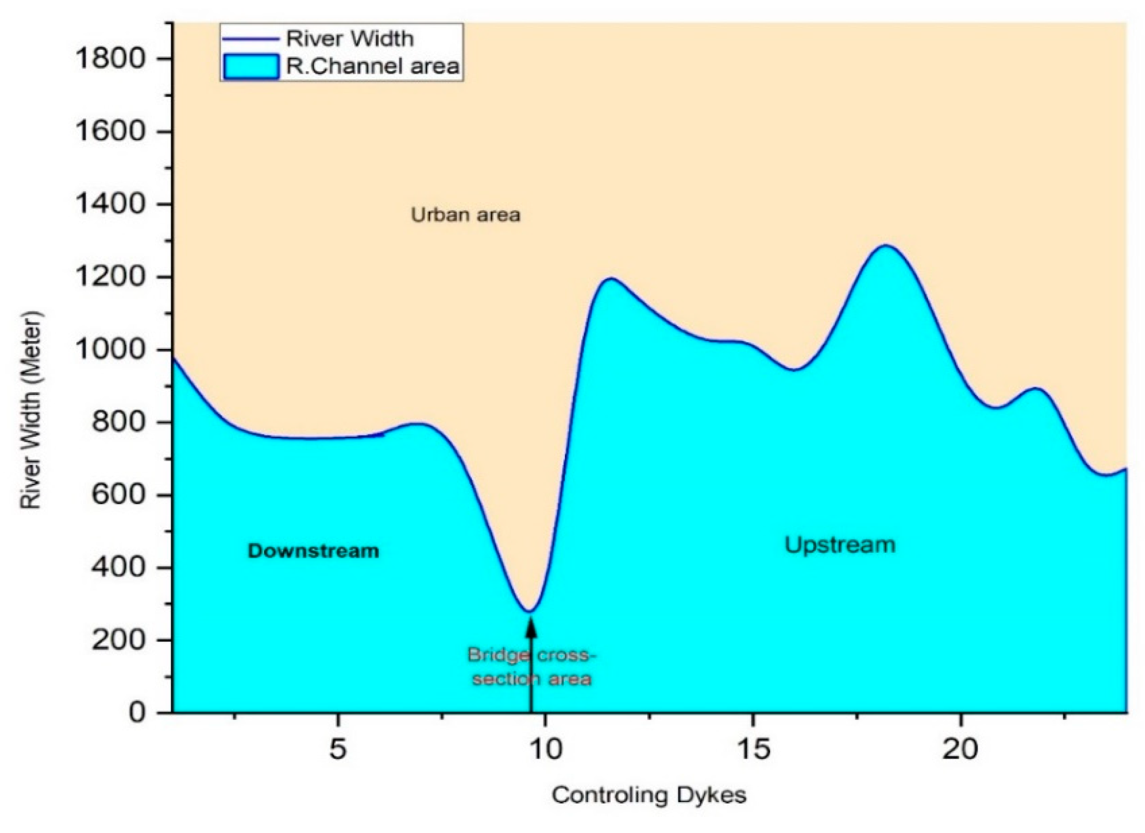
| Spurs | River Width | Spurs | River Width | ||
|---|---|---|---|---|---|
| 1 | Downstream | 1181 | 12 | Upstream | 1067 |
| 2 | 620 | 13 | 1011 | ||
| 3 | 541 | 14 | 1039 | ||
| 4 | 586 | 15 | 795 | ||
| 5 | 458 | 16 | 1047 | ||
| 6 | 813 | 17 | 1352 | ||
| 7 | 891 | 18 | 1689 | ||
| 8 | 731 | 19 | 896 | ||
| 9 | 375 | 20 | 796 | ||
| Kassala bridge | 129 | 21 | 974 | ||
| 10 | Upstream | 1280 | 22 | 621 | |
| 11 | 1160 | 23 | 573 | ||
| No | Non-Structural Measure | Project | Output | Outcome | Specific Objective | Impact |
|---|---|---|---|---|---|---|
| 1 | Early warning system | Rain gauge | 200 | 7 | 3% | Weak |
| Meteorological data center | 1 | 0 | 0% | Not implemented | ||
| 2 | Drain system | Drainage canals (downstream) | 27 m3/s | 5 m3/s | 18.5% | Moderate |
| Artificial recharges of groundwater | 10 | 0 | 0% | Not implemented | ||
| 3 | Soil conservation activities | Increasing vegetation cover in the catchment area | 1 | 0 | 0% | Not implemented |
| 4 | Land use and stakeholders | Natural resources committee | 1 | 0 | 0% | Not implemented |
| 5 | Insurance | Flood insurance | 1 | 0 | 0% | Not implemented |
| 6 | Maintenance | Budget | 420,000 USD | 54,000 USD | 13% | Weak |
Disclaimer/Publisher’s Note: The statements, opinions and data contained in all publications are solely those of the individual author(s) and contributor(s) and not of MDPI and/or the editor(s). MDPI and/or the editor(s) disclaim responsibility for any injury to people or property resulting from any ideas, methods, instructions or products referred to in the content. |
© 2024 by the authors. Licensee MDPI, Basel, Switzerland. This article is an open access article distributed under the terms and conditions of the Creative Commons Attribution (CC BY) license (https://creativecommons.org/licenses/by/4.0/).
Share and Cite
Shuka, K.A.M.; Wang, K.; Abubakar, G.A.; Xu, T. Impact of Structural and Non-Structural Measures on the Risk of Flash Floods in Arid and Semi-Arid Regions: A Case Study of the Gash River, Kassala, Eastern Sudan. Sustainability 2024, 16, 1752. https://doi.org/10.3390/su16051752
Shuka KAM, Wang K, Abubakar GA, Xu T. Impact of Structural and Non-Structural Measures on the Risk of Flash Floods in Arid and Semi-Arid Regions: A Case Study of the Gash River, Kassala, Eastern Sudan. Sustainability. 2024; 16(5):1752. https://doi.org/10.3390/su16051752
Chicago/Turabian StyleShuka, Kamal Abdelrahim Mohamed, Ke Wang, Ghali Abdullahi Abubakar, and Tianyue Xu. 2024. "Impact of Structural and Non-Structural Measures on the Risk of Flash Floods in Arid and Semi-Arid Regions: A Case Study of the Gash River, Kassala, Eastern Sudan" Sustainability 16, no. 5: 1752. https://doi.org/10.3390/su16051752