
Early Detection of Earthquakes Using IoT and Cloud Infrastructure: A Survey
by
 , , , and
Mohamed S. Abdalzaher
1,*,
Moez Krichen
2,3,
Derya Yiltas-Kaplan
4,
Imed Ben Dhaou
5,6,7 and
Wilfried Yves Hamilton Adoni
8,9
1
Department of Seismology, National Research Institute of Astronomy and Geophysics, Cairo 11421, Egypt
2
Faculty of Computer Science and Information Technology, Al-Baha University, Al-Baha 65528, Saudi Arabia
3
ReDCAD Laboratory, National School of Engineers of Sfax, University of Sfax, Sfax 3029, Tunisia
4
Department of Computer Engineering, Faculty of Engineering, Istanbul University-Cerrahpaşa, Istanbul 34320, Türkiye
5
Department of Computer Science, Hekma School of Engineering, Computing and Informatics, Dar Al-Hekma University, Jeddah 22246, Saudi Arabia
6
Department of Computing, University of Turku, 20500 Turku, Finland
7
Higher Institute of Computer Sciences and Mathematics, Department of Technology, University of Monastir, Monastir 5000, Tunisia
8
Helmholtz-Zentrum Dresden-Rossendorf, Center for Advanced Systems Understanding, Untermarkt 20, 02826 Görlitz, Germany
9
Helmholtz-Zentrum Dresden-Rossendorf, Helmholtz Institute Freiberg for Resource Technology, Chemnitzer Str. 40, 09599 Freiberg, Germany
*
Author to whom correspondence should be addressed.
Sustainability 2023, 15(15), 11713; https://doi.org/10.3390/su151511713
Submission received: 10 June 2023
/
Revised: 11 July 2023
/
Accepted: 26 July 2023
/
Published: 28 July 2023
(This article belongs to the Special Issue Artificial Intelligence (AI) and the Internet of Things (IoT) for Sustainable Applications)
Abstract
:Earthquake early warning systems (EEWS) are crucial for saving lives in earthquake-prone areas. In this study, we explore the potential of IoT and cloud infrastructure in realizing a sustainable EEWS that is capable of providing early warning to people and coordinating disaster response efforts. To achieve this goal, we provide an overview of the fundamental concepts of seismic waves and associated signal processing. We then present a detailed discussion of the IoT-enabled EEWS, including the use of IoT networks to track the actions taken by various EEWS organizations and the cloud infrastructure to gather data, analyze it, and send alarms when necessary. Furthermore, we present a taxonomy of emerging EEWS approaches using IoT and cloud facilities, which includes the integration of advanced technologies such as machine learning (ML) algorithms, distributed computing, and edge computing. We also elaborate on a generic EEWS architecture that is sustainable and efficient and highlight the importance of considering sustainability in the design of such systems. Additionally, we discuss the role of drones in disaster management and their potential to enhance the effectiveness of EEWS. Furthermore, we provide a summary of the primary verification and validation methods required for the systems under consideration. In addition to the contributions mentioned above, this study also highlights the implications of using IoT and cloud infrastructure in early earthquake detection and disaster management. Our research design involved a comprehensive survey of the existing literature on early earthquake warning systems and the use of IoT and cloud infrastructure. We also conducted a thorough analysis of the taxonomy of emerging EEWS approaches using IoT and cloud facilities and the verification and validation methods required for such systems. Our findings suggest that the use of IoT and cloud infrastructure in early earthquake detection can significantly improve the speed and effectiveness of disaster response efforts, thereby saving lives and reducing the economic impact of earthquakes. Finally, we identify research gaps in this domain and suggest future directions toward achieving a sustainable EEWS. Overall, this study provides valuable insights into the use of IoT and cloud infrastructure in earthquake disaster early detection and emphasizes the importance of sustainability in designing such systems.
1. Introduction
On 6 February 2023, a Mw 7.8 earthquake destroyed southern and central Turkey as well as northern and western Syria. 37 km (23 miles) west-northwest of Gaziantep is where the epicenter was. The earthquake near Antakya, Hatay Province, peaked with a Mercalli rating of XII (Extreme) as mentioned in [1]. The epicenter of the strong earthquake, followed by the one that occurred on February 6 by nine hours, was 95 km (59 miles) to the north-northeast of the most recent one. There was significant destruction and tens of thousands of deaths. At least 57,300 fatalities had been reported as of 20 March 2023, with more than 50,000 of those occurring in Turkey and more than 7200 in Syria [2].
It was the deadliest natural disaster in the history of Turkey and the largest natural disaster to hit Turkey in modern times since the earthquake in Antioch in 526 [3]. Aside from being the deadliest earthquake since the 1822 Aleppo earthquake in modern-day Syria, it was also the worst earthquake worldwide since the 2010 Haiti earthquake and the sixth deadliest of the twenty-first century [4]. The fourth-costliest earthquakes on record, damages in Turkey were expected to total USD 104 billion, and in Syria, USD 5.1 billion [5].
There are strong correlations between earthquakes, climate changes, and mining activities [6,7,8]. Many scientists have predicted that the frequency of earthquakes will keep increasing [9]. Figure 1 illustrates the location of earthquakes that occurred in the last 12 months with intensity larger than 7 Moment W-phase (Mww). In [10], the first paper on the idea of earthquake early warning systems (EEWS) in 1985 was presented. These systems are networks of ground-based sensors that alert users when the earth starts to tremble.
EEWS operates under the assumption that, despite the slow speed at which seismic waves move, electronic alerts from the epicenter region may be delivered almost instantly. The process is as follows:
- Several types of seismic waves radiate from an earthquake’s epicenter. Sensors are activated by P-waves, which are weaker but move more quickly. Thereafter, sensors send signals to cloud servers for processing.
- Algorithms in the cloud server instantly determine the location, magnitude, and severity of an earthquake. How big is it? Who will suffer from this?
- The technology sends out an alert before slower but more destructive S-waves and surface waves arrive.
Those who are close to the epicenter will not receive much, if any, warning beforehand, while those who are farther away could only have a few seconds to brace themselves. EWS may help reduce some of the injuries and damage caused by large earthquakes when used in conjunction with automated countermeasures such as stopping trains or turning off gas lines.
Recent years have seen a significant increase in the number of traditional as well as contemporary technology utilized in EEWSs [12,13,14]. As a consequence of this, effective integration of the numerous scientific fields is sought after in order to serve such crucial systems. In general, actions taken to reduce risks, conduct seismic hazard assessments, determine site specifications, and the like can be of assistance in this regard [15,16,17,18,19]. Developing a reliable EEWS necessitates solving a number of issues that are impacted by the ongoing difficulties associated with earthquake catastrophes. These issues include the observation of earthquake characteristics, and the environment type [20,21,22,23,24,25].
Radio-frequency identification, satellite systems, the Internet of Things (IoT), network functions virtualization (NFV), 5G, software-defined networks (SDN), data networks, and a variety of other technologies have all been the focus of significant research in recent years in an effort to lessen the damage that earthquakes cause [26,27,28,29,30,31,32,33,34]. For instance, satellite systems have been used to track earthquake movements, and IoT sensors have been used to detect earthquakes and provide early warnings. Furthermore, 5G and SDN technologies have been deployed for real-time communication and data transmission in emergency situations. These technologies have greatly enhanced the accuracy and speed of earthquake detection and warning systems and have improved the response time of emergency services.
Moreover, the integration of robots and the internet has the potential to be a significant breakthrough in this field. According to [35], a new integrated system named “robot-event” has been proposed, which is able to execute autonomous inspections and emergency responses to a severe event. The robot uses real-time image tracking to inspect the indoor environment and help any human victims found on the ground. It operates in structurally sound houses with moderate damage, focusing on situations where people are at risk from falling furniture. The system was tested indoors to assess its functionality and operation alongside a smart EEWS. This new technology has the potential to significantly reduce the risk of human casualties during an earthquake by providing timely and accurate information to emergency responders. Future research in this area could explore further the use of robotics, artificial intelligence, and the internet to develop more advanced and efficient EEWSs.
The research conducted in the literature regarding remote sensing applications facilitated by satellite communication systems did not cease with the studies by [36,37]. It also encompassed NFV and SDN, which involved gateways via IoT as well as Micro-Electro-Mechanical systems (MEMS), as noted in [38,39,40,41]. The primary objective of this endeavor was to provide relief to areas that had suffered damage or destruction on a large scale. Virtualization played a critical role in this, as it could help mitigate the risks posed by natural disasters. As highlighted in [42], such networks must be designed to optimize node lifetimes. In addition, ref. [43] presented a tragic scenario that showcased an EEWS designed to facilitate a safe evacuation plan against disaster risks by combining cloud-based IoT with heterogeneous networks. Similarly, the combination of IoT and current communication technologies and techniques could prove to be crucial in ensuring the smooth and secure transfer of data, as stated in [44,45,46,47,48,49].
The studies mentioned here are accompanied by conventional approaches to earthquake detection and analysis, as well as methods for distinguishing between different types of fault ruptures, which have been extensively investigated in the relevant academic literature [50]. In [51], a local similarity earthquake detection approach based on the nearest neighbor method was proposed to determine whether an earthquake had occurred by examining the consistency of received signals from the nearest neighbors of targeted stations and their closest neighbors. On the other hand, refs. [52,53] focused more on determining the earthquake’s amplitude in the first few seconds of its occurrence rather than the complete rupture. However, conventional methods take a significant amount of time to calculate earthquake parameters [54], highlighting the need for additional efforts and studies. Early research suggests that it is possible to accurately predict the magnitude and depth of an earthquake using a graph CNN model that employs batch normalization and attention mechanism techniques. This model can be used in any location with any seismic nodes. The variability of seismic waves and the complexity of the Earth’s structure suggest that there is ample room for innovative and adaptable solutions. With the help of modern technologies, the impact of earthquakes on the studied region in [54] can be significantly reduced.
An increasingly useful technology for disaster management is drones. They can be used to gather real-time data and give emergency responders situational awareness, which can aid in improved decision-making and more efficient responses. Drones with cameras and sensors can survey disaster regions swiftly and safely, collecting precise imagery and data that can be used to assess damage, spot areas that require immediate attention, and organize rescue and recovery efforts [55]. Drones can also be used to transport people in hazardous or hard-to-reach locations necessary goods such as food and medical supplies [56]. Drones are an important tool in emergency management because they have the potential to greatly speed up and enhance the efficiency of disaster response efforts.
5G and B5G networks offer several advantages for emergency communication, including faster data transmission speeds, lower latency, and improved reliability [57,58,59]. These networks can enable real-time communication between emergency responders and affected individuals, as well as the seamless transfer of data and video feeds from IoT devices, such as sensors and drones [60,61,62].
In particular, D2D communication can play a crucial role in emergency situations, as it allows devices to communicate directly with each other without relying on a centralized network [63,64]. This can be especially useful in scenarios where network infrastructure may be damaged or overloaded, as D2D communication can operate on a peer-to-peer basis and bypass the need for a central network [65,66]. In an earthquake early warning system, D2D communication could allow sensors to share data with each other and trigger alerts in real-time without relying on a centralized system [67,68].
Edge computing can also be leveraged to enhance the performance of earthquake early warning systems [69,70]. By processing data closer to the source, edge computing can reduce the amount of data that needs to be transmitted to centralized servers and enable faster response times [71,72]. For example, in an earthquake early warning system that uses drones to collect data, edge computing could be used to process the data on the drones themselves, rather than transmitting it back to a central server for processing [73,74]. This would not only reduce the amount of data that needs to be transmitted but also enable faster response times in the event of an earthquake [75].
Cloud computing helps manage disasters. Disaster management firms can swiftly deploy vital apps and services to assist emergency response activities using cloud platforms’ scalability, flexibility, and accessibility. Cloud-based technologies can monitor and analyze disaster data in real time, helping emergency responders manage resources. Cloud systems can store and handle enormous volumes of data, such as maps, satellite imaging, and social media feeds, to help businesses better analyze disasters. Cloud-based communication and collaboration solutions can also help rescuers communicate, coordinate, and stay linked during the pandemonium. Cloud computing may make disaster management businesses more agile, responsive, and effective in saving lives and minimizing damage. Fog and edge computing are distributed computing methods that provide computing resources near data sources. Fog computing is a dispersed computing infrastructure that processes data near its source. Edge computing brings computing resources to the end-user or device. Fog and edge computing are important in natural disaster detection and control. Natural disasters damage communication networks, making data collection and transmission difficult. Fog and edge computing provide local data processing and analysis without data centers or clouds. In the aftermath of a disaster, time is of the essence because communication infrastructure may be compromised [76,77,78,79].
For example, sensors deployed in an area prone to flooding can collect data on water levels, flow rates, and other factors that can help predict and manage the impact of a flood. By using edge and fog computing, this data can be analyzed in real-time, allowing for EWS to be put in place and emergency responders to be deployed more quickly [80]. Similarly, sensors can be used to detect seismic activity and predict earthquakes, with data processed locally to provide early warning and minimize damage.
Overall, fog and edge computing play an important role in natural disaster detection and management by enabling real-time data processing and analysis at the edge of the network [81]. This approach can help improve the speed and accuracy of disaster response, ultimately leading to better outcomes for affected communities.
Verification and validation (V&V) techniques are crucial for ensuring the quality, reliability, and security of software systems in the context of IoT and cloud computing [82,83]. These systems involve a complex network of devices, sensors, and services that must work together seamlessly and securely [84]. V&V techniques provide a framework for testing and validating these systems, ensuring that they meet the specified requirements and perform as intended. By implementing V&V techniques, developers can identify and correct defects and errors before they cause significant problems, ultimately leading to higher quality and more reliable IoT and cloud systems [85].
In [86], the authors reviewed geospatial and remote sensing technologies in earthquake research and disaster management, analyzing their historical and future applications, limitations, and methodologies. It provides a framework for earthquake hazard, vulnerability, and risk analysis using geospatial technologies. In [87], the study examined remote sensing applications, including Landsat satellite imaging, LiDAR, optical satellite photography, InSAR, and DEMETER in earthquake research. Many other studies [88,89,90] explore the role of IoT in disaster management and compares IoT-based options for various calamities. It highlights IoT EWS for fires and earthquakes and advises stakeholders on leveraging IoT technology to secure smart cities’ infrastructure and minimize risks. The studies also evaluate Caribbean DRM (Disaster and Risk Management) systems, emphasizing the need for technology and new methods in monitoring disaster risks in small island states. It assesses technology in the five DRM pillars and proposes improvements for technology adoption in the Caribbean subregion. The research contributes to the global discussion on technology and innovation in DRM and addresses sustainable development concerns in Caribbean SIDS (Small Islands Developing States).
The review paper [91] explores building damage mapping techniques in post-earthquake scenarios, emphasizing machine learning (ML) and deep learning frameworks. It addresses the drawbacks of manual interpretation of remote sensing imagery and identifies research gaps. The study of [92] reviews remote sensing methods for earthquake risk assessment, highlighting the importance of vulnerability assessment and the need for a comprehensive approach. In [93], satellite remote sensing technology for EEWS is suggested to achieve more improvements for EWS. The research of [94] examines post-earthquake damage investigation using optical remote sensing data and change detection algorithms, discussing their challenges and potential. The authors in [95] analyze how emerging technologies improve disaster management processes and call for further investigation. Lastly, the work done in [96] presents a procedure for managing pre- and post-earthquake stages of structure management using digital tools and emphasizes the role of BIM models and IDM standards.
Compared to previous works, our paper presents a comprehensive overview of the role of EEWS in disaster assessment and relief, specifically focusing on the use of IoT networks and cloud infrastructure. The paper provides fundamental concepts about seismic waves and associated signal processing, details on the EEWS IoT system, and a taxonomy of EEWS approaches using emerging IoT and cloud facilities. Additionally, our paper elaborates on a generic IoT-enabled EEWS architecture, discusses drones’ role in disaster management, and provides a summary of the primary verification and validation (V&V) methods required for the systems under consideration. Finally, the paper describes research gaps in this research domain and provides future directions. While previous papers have discussed geospatial technologies, remote sensing, and social media platforms’ use in earthquake research, disaster management, and catastrophe response, our paper focuses on the role of IoT and cloud infrastructure in EEWS and provides a comprehensive overview of the many elements needed to realize an EEWS.
Table 1 is intended to provide a comparison of our work with previous works in the field of earthquake research and disaster management. It summarizes the main focus, methodology, and contributions of each paper, highlighting the unique contributions of our work in relation to other research in this domain.
The following is a list of the key contributions that the paper makes, highlighting the various points of innovation:
- We clarify why the EEWS is advantageous for smart cities.
- We emphasize the growth of IoT usage, as well as the IoT system framework in general and its constituent parts.
- We have developed a thorough taxonomy of IoT devices that includes various topics such as the source of data, environment, measured parameters, and factors of validation.
- We present a standard design for the IoT that takes into account potential emergency management.
- We discuss the verification and validation concerns related to using IoT-based EEWS.
The rest of the paper is organized as follows. Section 2 illustrates some generic notions about seismic waves and signals. Section 3 provides an overview of IoT-Cloud systems. Section 4 depicts the IoT and cloud techniques integration in terms of EEWS. Section 5 presents an overview of the verification and validation issues associated with the use of IoT-Cloud-based EEWS. Section 6 lists the main open challenges, concludes the work, and identifies some potential future work directions.
2. Seismic Waves and Seismic Signal Processing Techniques
Seismic activity is a key subject of investigation. Understanding how different types of structures respond to earthquake loads and finding out how to safeguard occupants of a structure in an earthquake are both aided by this knowledge.
The study of seismicity can help us better understand the many seismic wave types that are generated, allowing us to map both the regions that are earthquake-prone and those that are not. Studying a region’s seismic activity aids in establishing minimum safety requirements for that area, making it simpler for life to go on after an earthquake [97,98].
Acoustic energy, known as a seismic wave, can move through the Earth or another planetary body. It could be caused by a quake (or an earthquake more generally), a volcanic eruption, the movement of magma, a big landslide, or a sizable explosion brought on by human activity, such as mining, which releases low-frequency acoustic energy. Seismologists are responsible for investigating seismic waves. To record the waves, seismologists use accelerometers, hydrophones, or seismometers that are submerged in water [99]. It is important to differentiate seismic waves from seismic noise, also known as ambient vibration, which is characterized by a continuous low-amplitude vibration and can be caused by a wide variety of natural and artificial sources. Arrays of sensors are typically used in seismic signal processing, which is followed by signal conditioning and data fusion. An ADC converter is then used to digitize the gathered data, and a microcontroller is used to process it. This is referred to as an IoT node in the context of the IoT, and it is shown in Figure 2.
It is possible to differentiate between the two types of seismic waves known as body waves, which move through the inside of the planet, and surface waves, which move along the surface of the planet. Body waves flow through the interior of the Earth in a manner that is determined by the paths that are created by material properties such as density and modulus (stiffness). Temperature, chemical composition, and the state of the material all have an effect on the material’s modulus and density. This phenomenon can be compared to the refraction of light waves. On the basis of how particles move, body waves can be divided into two distinct categories: primary and secondary waves. Around the year 1830, the French mathematician Siméon Denis Poisson identified this distinction as follows [100]:
- Primary waves, also referred to as P-waves, are longitudinal compressional waves that move through the earth in a straight line. These waves are known as “primary” waves because they arrive first at seismograph stations, traveling faster through the earth than other types of waves. P-waves are pressure waves that can travel through any material, including fluids, and move at a speed that is around 1.7 times faster than that of S-waves. In contrast to S-waves, which are transverse waves that move side-to-side, P-waves are compression waves that cause particles in the material they are traveling through to move back and forth in the direction of the wave’s propagation. They take the form of sound waves in the air and move at the same velocity as sound waves, which is around 330 m per second on average. The ability of P-waves to travel through any material allows them to be used to study the interior of the earth. By measuring the time taken for P-waves to travel through the earth from an earthquake’s epicenter to a seismograph station, scientists can calculate information about the earth’s internal structure. For example, the average speed of P-waves in granite is roughly 5000 m per second, while in water, it is around 1450 m per second. This information can be used to create a detailed model of the Earth’s interior.
- S-waves, also known as secondary shear waves, are transverse waves that cause the ground to shift in a direction perpendicular to their propagation during an earthquake. These waves arrive at seismograph stations after P-waves, which are faster. S-waves have a horizontal polarization and move in a horizontal direction, causing the ground to shift from side to side. However, S-waves can only travel through solids since liquids and gases do not support shear forces. They move through any solid medium at a speed that is approximately 60% slower than P-waves. The absence of S-waves in the outer core of the Earth is consistent with the presence of liquid. This is because S-waves cannot propagate through liquids, and their absence indicates that the outer core is predominantly liquid. However, P-waves can propagate through liquids, which is why they can travel through the entire Earth. The study of seismic waves and their behavior has provided scientists with valuable insights into the structure and composition of the Earth’s interior.
The path that seismic surface waves take along the surface of the Earth [101]. These are an example of a type of surface wave known as mechanical surface waves. They are referred to as surface waves because their strength decreases as they go away from the ocean’s surface. They move at a much slower pace compared to seismic body waves (P and S). The amplitude of surface waves can reach several millimeters during particularly powerful earthquakes.
Seismographs that are situated at a greater distance from the epicenter of an earthquake are unable to detect the high frequencies of the first P wave. In contrast, seismographs that are situated closer to the epicenter are able to record both the P and S waves that are generated when an earthquake takes place [102].
The problems that are associated with seismic data are probably unmatched by any others. During the course of the past few decades, the amounts of such data have nearly multiplied exponentially [103]. In recent acquisition studies, petabits of data are being processed on a daily basis. This requires massive processing capabilities. It should, therefore, not come as a surprise that data formats have evolved significantly over the years and that they have been altered to meet particular workflows or software solutions, which has added to the complexity of managing data [104].
In recent years, the industry of exploration and production has been dealing with “big data” in the form of seismic data [105]. This data is collected during seismic surveys. As more and more varieties of data are gathered and reprocessed for a variety of purposes, the amount and volume of data continue to grow at an alarming rate. It is necessary to locate and manage both field and prestack data because new insights can be derived from old data by applying updated seismic processing methods. Because of this, it is important to keep track of both sets of data. Several companies made the decision to store this information on tapes because of the massive size of seismic data files and the prohibitively expensive cost of disk space. However, tapes were difficult to handle and regularly went missing, so this was not an ideal solution. Web-based viewers and administration tools make it easier to discover and handle data from anywhere in the world. At the same time, tiered storage and cloud storage offer new and more cost-effective means of keeping enormous seismic datasets [106]. Figure 3 shows the enhancements of the utilized earthquake measurement.
Seismic wave analysis is a key component of earthquake early warning systems, as it enables the detection and characterization of seismic waves in real-time [107,108]. One of the most widely used signal processing techniques in seismic wave analysis is the Fourier transform, which is used to transform time-domain signals into frequency-domain signals [109,110]. In earthquake early warning systems, the Fourier transform is often used to analyze the spectral content of seismic waves, which can provide important information about the location, magnitude, and duration of an earthquake [111]. The Fourier transform is also used to filter out noise and unwanted signals from seismic data, improving the accuracy of earthquake detection and analysis [112].
Another advanced signal processing technique used in seismic wave analysis is wavelet analysis, which is used to analyze signals that are both time-varying and non-stationary [113,114,115]. In earthquake early warning systems, wavelet analysis is often used to detect and analyze seismic waves that have complex frequency components, such as those generated by slow earthquakes or volcanic activity [116,117]. By decomposing a seismic waveform into its constituent frequency components, wavelet analysis can provide more detailed information on the characteristics of seismic waves, such as their frequency content, duration, and amplitude [118,119].
In addition to these advanced signal processing techniques, earthquake early warning systems also rely on a variety of specific parameters to optimize their performance [120,121]. These parameters include sampling rates, window sizes, and filter cutoff frequencies, among others. Sampling rates determine how often seismic data is collected and stored, while window sizes determine the length of time over which seismic data is analyzed. Filter cutoff frequencies determine which frequency components of a seismic waveform are analyzed and are often used to remove noise and unwanted signals from seismic data.
In conclusion, earthquake early warning systems rely on a variety of advanced signal processing techniques and specific parameters to detect and analyze seismic waves in real time. By providing more detailed information on these techniques and parameters, we aim to enhance the technical rigor of our paper and improve the understanding of the underlying technology. By optimizing the performance of earthquake early warning systems through advanced signal processing techniques and specific parameters, we can improve the accuracy and effectiveness of these systems, ultimately helping to save lives and reduce the impact of earthquakes on communities.
3. IoT-Cloud Systems
3.1. IoT Systems
The IoT is gaining increasing support as a viable new technology throughout the world [122,123]. An IoT is a system that relies on connected embedded items or gadgets that have identifiers and are able to interact with one another without the assistance of humans using a common communication protocol. It has been reported that there are more internet-connected devices on the earth than there are humans, where these devices support the smart cities establishment [124,125,126]. Some smart cities are already in existence [127]. The growth of intelligent technology is outlined on Statista’s website [128] under Figure 4. As has been suggested, an enormous increase in smart homes as well as commercial buildings, and important requirements for these buildings will include intelligent electricity and water management [129]. Statista projects that the number of IoT devices will nearly triple between 2020 and 2030, going from 9.7 billion in 2020 to more than 29 billion in 2030. Over 5 billion consumer IoT devices are expected to exist in China by 2030. Accordingly, it is the nation with the majority of these devices. Consumer markets make use of IoT devices; nevertheless, it is anticipated that the consumer market will account for more than 60 percent of all IoT-connected devices by the year 2020 [128]. For the next decade, it is anticipated that this proportion will not change from its current value.
According to [130,131,132,133,134], several industry verticals now have more than 100 million connected IoT devices, including government, retail and wholesale, transportation and storage, electricity, steam, gas, air conditioning, waste management, water supply, and retail and wholesale. It is predicted that by 2030, over 8,000,000 IoT nodes will be employed in all industries [128]. In addition, cell phones can represent the best contributor to IoT nodes. Interestingly, it is expected to reach nearly 17 billion by 2030, and more than one billion would be used to connected (autonomous) vehicles [128], information technology infrastructure, asset tracking and monitoring, and smart grids [135,136,137].
While configuring an IoT system, the following steps should be carried out in accordance with established industry standards [138,139,140,141,142,143]:
- Providing the node with an interface that can collect data from the environment.
- Providing a tool for acquiring and analyzing data in order to derive knowledge from it.
- Taking action and communicating choices and information to the appropriate hubs.
To gain a comprehensive understanding of an IoT solution’s architecture, it is necessary to examine multiple IoT systems. As shown in Figure 5, an IoT system’s framework typically consists of a sensor network that monitors changes in the surrounding environment. Depending on the required transmission speed and distance, the collected stream should be transmitted to a centralized or decentralized administration using, e.g., Zigbee, Bluetooth, Tmote Sky, 4G, etc. It is important to note that the sensor system needs a continuous source of electricity, and the choice of connectivity is influenced by power consumption, with mobile service requiring more power than WiFi, 474.67 to 576.64 mW and 1254.3 to 1540.6 mW, respectively [144]. Safety considerations for both hardware and connectivity are also crucial. An IoT system’s data is reviewed or saved in the cloud system to identify patterns and extrapolate information, a critical requirement for any IoT system. The data can be simplified using data visualization, and alert systems can be implemented to provide appropriate levels of caution to users. It is essential that IoT system design is not limited to industry professionals only.
The IoT has the potential to revolutionize methods of detecting and managing disasters. With the help of IoT devices, we can collect real-time data on various environmental factors such as temperature, humidity, air pressure, and wind speed, which can help us detect natural disasters such as hurricanes, floods, and earthquakes. These devices can also monitor infrastructure such as bridges, dams, and buildings for any signs of damage or weakness and alert authorities before they collapse or fail, preventing further damage and loss of life.
Moreover, IoT can aid disaster management by providing real-time updates on the affected areas, helping authorities plan and allocate resources effectively. Smart sensors and cameras can be deployed to assess the extent of the damage in disaster-stricken areas, and drones can be used to reach inaccessible areas and gather more information. This data can be analyzed using ML algorithms to identify patterns and predict future disasters [145,146], improving the accuracy of EWS and minimizing the impact of disasters.
Another significant advantage of IoT in disaster management is its ability to facilitate communication between emergency responders and victims. Wearable devices and mobile apps can help victims send alerts and SOS messages, and responders can use IoT devices to locate and rescue survivors in real time. IoT can also help in tracking the movements of rescue teams and ensuring their safety.
The use of IoT for disaster detection and management has the potential to save countless lives and minimize the impact of disasters. By leveraging IoT devices to collect real-time data, authorities can detect disasters early, manage resources effectively, and respond quickly to save lives. However, it is crucial to address concerns about data privacy and security to ensure the safe and ethical use of IoT in disaster management.
Drones, also known as unmanned aerial vehicles (UAVs), have come a long way since their inception in the early 20th century [147]. Initially used for military purposes, drones have evolved and diversified over time, and today they have a wide range of applications in various fields, including photography, agriculture, search and rescue, and disaster management [148]. In addition, it can be equipped with thermal imaging sensors that can also be used to detect the presence of survivors in collapsed buildings or other hard-to-reach areas [149].
There are several types of drones (Figure 6), each with unique characteristics and capabilities. The most common types of drones are fixed-wing, rotary-wing, and hybrid drones. Fixed-wing drones are similar to airplanes and can fly for longer distances, while rotary-wing drones, also known as quadcopters, are more agile and can hover in place. Hybrid drones combine features of both fixed-wing and rotary-wing drones, providing a balance between endurance and agility.
Drones can be involved in various types of communications (Figure 7), including visual, auditory, and data communication. Visual communication involves transmitting images and videos captured by the drone’s camera to a remote operator or a ground station. Auditory communication can include transmitting audio messages, such as warnings or instructions, to individuals or groups on the ground via a speaker on the drone. Data communication involves transmitting data, such as telemetry and sensor readings, between the drone and a ground station or another device. Additionally, drones can be equipped with communication technologies such as satellite communication, Wi-Fi, and cellular networks to enable long-range communication and control. In [150], the authors exploited the UAVs to collect data for disaster management relying on 5G (fifth generation) and B5G (beyond 5G) systems with their huge capacity in terms of different data types. The authors investigated various literature solutions to some UAV issues, such as energy harvesting and security. For example, they mentioned a sample method that used UAVs to find the most suitable localization of the sensor nodes for optimizing Quality of Service.
In recent years, advances in technology have enabled the integration of new sensing and data collection methods into EEWS systems, including the use of drones [151,152]. Drone-based sensing can provide high-resolution data on earthquake characteristics, such as ground motion and deformation, which can improve the accuracy and effectiveness of EEWS systems [153,154]. The main advantages and limitations of the use of drones is summarized in Table 2.
Real-time communication is also essential for the timely dissemination of earthquake alerts, and various communication technologies, including satellite and wireless networks, are used to transmit sensor data and alerts to processing centers and end-users [155]. In addition, the integration of EEWS systems with IoT and cloud infrastructure can provide scalability, fault-tolerance, and data processing capabilities [156]. IoT devices, such as accelerometers and GPS sensors, can provide additional data sources for earthquake monitoring and analysis. In contrast, cloud infrastructure can provide storage and processing capabilities for large-scale data analysis and modeling [157]. Coordination between these various technical aspects is essential for the successful deployment and operation of EEWS systems, and careful consideration of their capabilities, limitations, and interdependencies is necessary to ensure their effectiveness in mitigating the impact of earthquakes [158].
3.2. Cloud and Fog Systems
Cloud computing is a model of delivering computing resources, such as servers, storage, databases, and software, over the internet on an on-demand basis [159]. It provides users with easy access to a wide range of computing resources that can be scaled up or down based on demand without requiring users to invest in and maintain their own physical infrastructure. Fog computing, on the other hand, is a distributed computing model that brings computing resources closer to the edge of the network, closer to where data is generated and consumed, and provides real-time processing and decision-making capabilities [160].
The importance of cloud and fog computing in natural disaster detection and management cannot be overstated. Natural disasters such as hurricanes, earthquakes, floods, and wildfires can cause widespread devastation and loss of life. The use of cloud and fog computing in disaster management can help to mitigate the effects of these disasters by providing real-time data analysis, decision-making, and communication capabilities [161].
Cloud computing can be used to store and process large amounts of data generated by sensors and other devices used in disaster management. This data can be analyzed in real-time, providing EWS to alert authorities and the public of impending disasters. Cloud computing can also be used to store and share critical data such as emergency response plans, evacuation routes, and contact information for emergency services.
Fog computing can be used to process and analyze data at the edge of the network, near the source of the data. This can provide real-time information about the status of infrastructure such as roads, bridges, and buildings, allowing authorities to make informed decisions about evacuation and emergency response efforts. Fog computing can also be used to provide real-time communication capabilities, allowing emergency services to coordinate their efforts and communicate with each other and the public in real time.
In summary, cloud and fog computing play a critical role in natural disaster detection and management. They provide real-time data analysis, decision-making, and communication capabilities, allowing authorities to respond quickly and effectively to disasters, potentially saving countless lives and minimizing the damage caused by these events.
4. IoT-Cloud-Based EEWS
This section will highlight the significant significance that the IoT-Cloud technology plays in EEWS. In point of fact, the application of IoT-Cloud strategies has been of assistance to EEWS before and after disasters.
The IoT has revolutionized the way we interact with the physical world, and one of its most promising applications is in the detection and prediction of natural disasters such as earthquakes. The basic idea behind using IoT for earthquake detection is to deploy a network of sensors that can detect seismic activity and transmit the data to a central server for analysis. These sensors can be embedded in buildings, bridges, and other structures, as well as in the ground itself. By analyzing the data from these sensors, it is possible to detect the onset of an earthquake and predict its magnitude and location.
One of the key advantages of using IoT for earthquake detection is that it allows for real-time monitoring of seismic activity. Traditional methods of earthquake detection rely on seismometers, which are expensive and require a lot of maintenance. They also typically only provide data after an earthquake has already occurred. In contrast, IoT sensors can provide continuous data in real-time, allowing for EWS to be put in place [162,163,164]. This can be particularly useful in areas prone to earthquakes, where early warning can save lives and reduce damage.
Another advantage of using IoT for earthquake detection is that it can provide more denser data network than traditional methods. IoT sensors can be placed in a wider variety of locations, such as inside buildings or underground, allowing for a more comprehensive picture of seismic activity. They can also provide data on other factors that can affect the impact of an earthquake, such as soil conditions and building materials. This information can be used to develop better models for earthquake prediction and to design buildings and infrastructure that are more resistant to seismic activity.
The use of IoT for earthquake detection has the potential to revolutionize the way we prepare for and respond to earthquakes. By providing real-time data and more comprehensive information on seismic activity, IoT sensors can improve our ability to predict earthquakes and minimize their impact. As the technology continues to develop, we can expect to see more widespread deployment of IoT sensors and more sophisticated analysis techniques, leading to even better earthquake detection and prediction capabilities.
A generic EEWS architecture typically consists of three main components: the seismic network, the processing center, and the alert distribution system [165]. The seismic network comprises a set of sensors deployed across a region of interest, which detect and record seismic waves generated by earthquakes. The sensor data is transmitted to the processing center, where it is analyzed in real-time using algorithms and models to estimate the location, magnitude, and other characteristics of the earthquake [166]. The alert distribution system then disseminates the earthquake alert to end-users through various channels, such as mobile devices, sirens, and public announcements [167]. The underlying infrastructure of the EEWS includes a variety of hardware and software components, including seismometers, communication networks, computing systems, and databases [168]. The seismometers are typically deployed in a dense network to ensure high spatial resolution and coverage, and they are connected to a communication network that transmits the sensor data to the processing center [169]. The processing center comprises a set of computing systems that perform real-time data analysis, using a variety of algorithms and models to estimate the earthquake parameters [170]. The alert distribution system includes a set of communication channels and protocols that disseminate the alert to end-users, as well as a database that stores historical and real-time earthquake data [171]. The interactions between these components are tightly coordinated to ensure timely and accurate earthquake alerts, which can help to mitigate the impact of earthquakes and save lives [172].
In [173], the authors developed CrowdQuake, a DL-based seismic detection system. Utilizing a dense IoT network composed of MEMS nodes, the system employs a multi-head convolution neural network to analyze a large quantity of observed acceleration data. During the model validation procedure, the scientists got data from the National Research Institute for Earth Science and Disaster Prevention (NIED) and measured the precision-recall, accuracy, and noise level. The developed system could process data from up to 8000 IoT sensors, and identifying an earthquake required only a few seconds of processing time, according to the researchers. In [174], an advanced EEWS supported by an IoT network that operates on the basis of real-time alerts has been established. The network utilized MEMS accelerometers and an Arduino Cortex M4 CPU for measuring acceleration. This technique employs ML to improve the accuracy and latency in earthquake detection. The model was constructed using data gathered locally by the MEMS accelerometer nodes that were installed.
In [175], IoT acceleration nodes were designed explicitly for earthquake detection. Two methods are used to utilize these nodes: a technique of standalone and a technique of client-server. The first technique is more commonly used, while the client-server technique is more precise but requires high-performance servers and network infrastructure to manage data acceleration from multiple client machines. Basic earthquake detection methods can be independently explored on less capable mobile nodes. However, this may result in false alarms. To overcome this limitation, a cooperative method that uses a large number of mobile phones located in close proximity to one another is employed. This creates a seismic network that can detect earthquakes and monitors any shaking caused by human activity, mechanical vibrations, earthquakes, etc. By relying on a primary neural network, a motion similar to an earthquake detected by a smartphone is transmitted to other cellphones in the immediate area using a multi-hop mode. Furthermore, every mobile phone in the network determines and notifies the network of an earthquake, then triggers an alarm after obtaining detection data from other smartphones in its immediate vicinity. This technique improves the earthquake detection capabilities of a standalone method that does not use any system or network infrastructures.
In [176], a predictive model that combines IoT devices and ML techniques was used to detect geological landslide occurrences. The predictive model was trained with geotechnical parameters such as soil shear strength, soil moisture, rain intensity, terrain slope, and more. The actual hardware used for this purpose consisted of a collection of sensors that gathered real-time information on the topography and soil. In [177], the authors proposed a compute offloading system architecture that can be implemented on Internet-connected drones. They conducted an in-depth experimental study to compare the efficiency of cloud computing offloading strategy with that of the edge computing strategy for DL solutions in the context of unmanned aerial vehicles (UAVs). The authors investigated the balance between the computational cost of the two alternative options communications in an experiment.
In [53], a DL paradigm based on integrating autoencoder (AE) and CNN was developed to immediately determine earthquake magnitude and position three seconds after the P-wave begins. The authors referred to it as CNN and 3s AE (3S-AE-CNN). The data set used in the study was monitored by three stations of the Hi-net seismic network in Japan, and the approach was evaluated using data from 12,200 separate occurrences (109.80 thousand 3 s three-component seismic windows). The model simplifies the extraction of essential waveform properties, resulting in a higher degree of credibility in earthquake parameter assessment. The suggested model predicts magnitude, latitude, and longitude with an accuracy of within 28 × 10, 3.3 × 10, and 100 × 10 degrees, respectively. That model immediately communicates event features to a sink IoT node. It provides guidance to the relevant administration on how to proceed. It is noted that AE has proved beneficial in feature extraction regardless of the application [178].
The framework for earthquake prediction proposed in [179] is a novel approach based on federated learning (FL). This FL framework outperformed the previously developed ML model for earthquake estimation through an IoT gateway in terms of reliability and accuracy. The model achieved an accuracy of 88% by analyzing multidimensional data over a 100 km radial area, excluding the Western Himalayas, and studying the data. In [180], an EEW based on an IoT and an ML model was suggested to predict tsunamis using tsunami data dating back to 2100 BC and was trained on earthquake parameters in the dataset. It achieved an accuracy of 95% in predicting earthquake location, depth, and magnitude.
In [181], a DL approach that can identify P-waves despite background noise was developed using MEMS for observing events. The model can detect the probability of occurring preceding significant shocks and accurately predict P-waves between 1.5 and 2.5 s before their arrival. In [182], the authors used detector nodes to detect earthquakes locally by probing the environment and assessing data from probes in the surrounding area. The method stores all data locally, making it resistant to node failures and partial network outages, thus increasing privacy. The test network consisted of twenty node codes joined with ten neighbor nodes chosen at random. The total number of detectors was sampled every ten seconds. In [183], a Multilayer Perceptron-classifier was developed to provide a severity-based warning by predicting the possibility of an onsite intensity exceeding a pre-trained PGA threshold associated with damaging intensities on the MMI scale—seismic properties observed by the strong-motion signal starting from the P-wave in the developed model. The authors of [184] proposed an independent model of earthquake detection via low-cost acceleration nodes. The model utilized four different sensor types for establishing an EEWS with different types of data, e.g., noise from buildings, vibrations, and earthquake records. To test the sensors, two actual earthquakes were replicated on a shake table. The study found that low-cost acceleration sensors can detect earthquakes by monitoring differences in acceleration induced by a range between 0.02 g to 0.8 g, which can be detected by the sensors. Therefore, the authors used scaled data within that range.
An ML methodology with earthquake characteristics was utilized, as opposed to the more conventional seismic methodologies that are typically used [185,186,187]. The authors broke the detection problem down into two distinct groups, namely, static settings and dynamic settings. They provide the most effective ML approach and input data for the static environment based on an experimental evaluation of numerous features for circumventing the issue of discriminating earthquake and noise components to reduce the number of false alarms. This model was validated with the help of 385 earthquakes ranging in magnitude from 4.0 to 8.0.
The authors of the paper [188] introduced the Distributed Multi-Sensor Earthquake Early Warning (DMSEEW) system as a cutting-edge ML-based technique that includes data from GPS stations and earthquake sensors in order to recognize large and medium earthquakes. The model relies on an innovative stacking ensemble technique that has been validated by geoscientists using a real-world dataset. This approach was used to build DMSEEW. The architecture of the system was designed to be regionally spread, which allows for both brisk processing and resistance to disruptions in some aspects of the underlying infrastructure. To be more specific, these systems combined GPS and seismic data in order to enhance earthquake detection, which led to the creation of an efficient EEWS.
Karacı [189] used vibration sensors for earthquake detection according to some threshold values. If an earthquake has been detected via the vibration sensors, a warning system takes place. In this warning system, there is a Wi-Fi module for Internet connection to send a tweet by means of the ThingSpeak IoT analytics platform service. There is also a sound alarm via a buzzer for the people staying around the earthquake area. Thus, the electronic part of this study covers an Arduino card, Wi-Fi module, Inertial Measurement Unit sensor, vibration sensor card, and buzzer. The software part involves the codes of Processing with Arduino to obtain the sensor data normalization and the difference between sequential sensor values for monitoring the threshold level.
Babu and Rajan [190] have studied an IoT solution that alerts for a flood or earthquake detection before they happen and living beings being searched for during the disasters. Sensors are connected to a microcontroller, RF transmitter, and receiver. Their values are analyzed in real-time via ThingSpeak IoT analytics platform service [190]. The authorities are notified by GSM messages during a flood or earthquake disaster using the IP protocol. A water level sensor has been used for flood detection, and four color bulbs represent the danger levels. A rain sensor has worked to determine whether there is rain. Additionally, a vibration sensor has been used for an earthquake. The system and the mobile phones are charged with solar energy as a secure option for flood environments. ESP Wi-Fi module is the gateway as the fundamental processing and storage part between the RF receiver-transmitter-bulb system and ThingSpeak cloud server for sensor data transmission. This data can be followed using a ThingSpeak API that is used for mobile phones, laptops, or any other internet-connected device. Wireless communication, especially GPS, is used for living being searches.
Won et al. [191] proposed a high-fidelity vibration sensor consisting of a MEMS accelerometer with high sampling frequency and digital filtering. During the sensing process, Short-Term Average/Long-Term Average trigger is compared with a threshold value. Over the threshold, data acquisition, low-pass filtering, and downsampling to a frequency are performed. After this procedure, if an earthquake is detected with the proposed algorithm, the system notifies it through a Bluetooth Beacon. The authors mentioned that the hardware platform was Adafruit nRF52840 Feather Express developed based on nRF52840 (Nordic, 2019) board having fast computing and high storage attributes provided by CPU, RAM, and flash parts. Additionally, the nRF52840 module has Bluetooth 5 and Arduino IDE support.
Duggal et al. [192] mentioned that the literature studies could not separate any other vibrational noise properly from that of earthquakes. They proposed a new method by using IoT to eliminate this drawback. A Micro Electro-mechanical system sensor is set inside a building after finding the most suitable place via structural analysis with the information on seismic shear walls. Inside this sensor, there is an accelerometer and a gyroscope. The gyroscope saves the ground’s shaking pattern, representing a distinctive nature during an earthquake. IoT IC Communication Protocol is used between the devices in the network. Arduino Uno microcontroller board and NodeMCU Dev Kit firmware have interfaces with the sensor node. The sensor data is sent by Arduino inbuilt WiFi to the ML side. In this part, Logistic Regression, Support Vector Machine, and Convolutional Neural Networks have been used for modeling.
Sharma et al. [89] gave a table for ten different IoT disaster management systems based on several properties, such as IoT architecture ownership, cloud-enabled, computer technology area, main focus, and disaster type. They also classified IoT-based disaster recovery systems into four groups: Service-oriented, natural, artificial, and post-disaster. They compared IoT-enabled disaster management methods according to their wireless communication technologies, sensor types, and some additional features. They also put a comparison diagram exhibiting that Bluetooth and Wi-Fi were the best cost, and Bluetooth and ZigBee had the best power usage among the IoT communication technologies. The authors proposed case studies for forest fire detection and EEWS based on IoT devices. For the earthquake warning part, they mentioned the usage of Vibration Sensors (Accelerometer), PIC (Peripheral Device Controllers), ZigBee communication procedures, LCD monitors, and RS232 cables. An IoT alarm message was sent to smartphones, and an alarm message via GSM standard was sent to other cell phones.
Mishra et al. [193] have optimized a schedule for distributing relief items using IoT technologies, such as smart cities. There are some dynamic features dependent on the disaster conditions, such as changing relief demand and resource availability. IoT is suitable for such issues related to continuously flowing and dynamically changing data [194]. The authors symbolized different time periods with sliding time windows in which the data update occurs. For the first window, relief distribution is decided according to the availability of vehicles, relief resources, priority of the disaster area, and delivery routes. The distribution schedule has been optimized repeatedly in the next time slots.
The fragility of the problem that is being targeted, as well as its direct effect on human life, makes it imperative that a solution be found that is intelligent, trustworthy, and flexible despite the considerable efforts that have been put into developing the state-of-the-art. In this section, we throw light on the primary research explorations that have been done in this area. The primary efforts in developing IoT for the EEWS are outlined in detail in Table 3.
In order to prevent the loss of human life, the implementation of an EEWS is an absolute necessity. In order to effectively manage disasters and reduce the danger of earthquakes, it is essential to have the ability to promptly detect the features of an earthquake. With technologies already in place, such as the IoT network, social media, global positioning system (GPS), and mobile nodes, these attributes can be sent to help mitigate the effects of a catastrophic earthquake.
Figure 8 depicts a comprehensive EEWS with many administrations assisting in relieving the earthquake tragedy. The EEWS will include complete statistics regarding hospitals, railways, fire services, ambulances, airports, and so on based on these administrations. This proposed system does integrate social media, IoT technologies, cloud systems, and mobile systems. It operates in two stages. The first stage is pre-disaster, as ML models are used to detect the commencement of the principal wave. This procedure is extremely advantageous for risk minimization, such as rapid shutting down of nuclear power plants, electrical producers, and so on. The second phase begins after the disaster has occurred, with the goal of mitigating/reducing the disaster’s impacts. Using an integrated system, for example, allows for more accurate statistics regarding the affected people, buildings, utilities, and areas. As a result, an effective evacuation strategy can be implemented.
A solution that is both flexible and intelligent and that is able to deal with complex problems in a relatively short amount of time is required for such a system. ML has the potential to play a significant and critical part in the administrations that are interconnected and working on achieving successful EWS among the variety of existing current techniques. ML is a promising method that works regardless of the data type, format, length, and other factors such as these.
Indeed, real-time monitoring takes place across all of the dispersed organizations shown in Figure 8, which serves as the foundation for a reliable EEWS. As a consequence of this, the transfer of data between various entities needs to be thoroughly investigated and estimated. After that, ML models are utilized to zero in on the current status of each object and even provide an estimate for a certain word. As a consequence of this, those institutions are capable of making useful contributions prior to, during, and after earthquake disasters. To put it another way, a technique such as this can assist with the management of earthquake catastrophes, the reduction of earthquake risks, and evacuation tactics. As a consequence of this, the performance of the EEWS improves in direct proportion to the quality of the ML model. Figure 9 provides a visual representation of the interaction between trains as a specific administration used in the process of full EEWS, the data processing, and the research done. To be more precise, earthquake data is monitored to be sent for processing using the IoT network in order to carry out the desired check and determine the correct decision to send to the railway system for suitable action using an ML model and the railway information of the disaster location. This process is repeated until the appropriate decision is made.
The authors of [197] mentioned the same approach of benefiting from UAVs as Aerial Base Stations (ABSs) to provide connectivity instead of traditional base stations. They proposed two trajectory planning algorithms using a k-value selection method and K-means centroids for UAVs. These UAVs served to the clusters of user equipment. By enhancing the study, the authors also gave two methods for cluster head selection to support continuous connectivity via UAVs and cluster heads.
The authors of [198] suggested a system to find the damage degrees of various earthquake region parts such as roads and riverways. They used single-rotor and six-rotor UAVs and took visible light images of the region parts. Once the image quality evaluation was done according to the image contrast, the image blur, and the image noise formulas, the aerial images were analyzed with Gray Level Cooccurrence Matrix, the Tamura, and the Gabor wavelet features. Lastly, the SVM classifier was used to obtain the damage levels.
The authors of [199] proposed to use UAVs for monitoring earthquake impacts after the disaster occurrence. The damage to the buildings was derived with the help of one fixed-wing UAV and two multirotor UAVs. The aerial mapping gathered from the UAVs was compared with a physical field survey. The buildings’ structural properties were extracted from the damages on different parts of the surfaces, such as walls, roofs, and perimeter columns. Additionally, the liquefaction situation was seen from the area investigation that also presented the damage levels of the settlements.
Overall, the use of drones in earthquake disaster detection and management has the potential to save lives, speed up response times, and improve the efficiency of emergency services. As technology continues to advance, it is likely that drones will become an even more important tool in disaster management, helping to mitigate the effects of earthquakes and other natural disasters. Figure 10 shows the role of UAVs for three scenarios of pre, during, and post-disaster situations.
Evaluating the performance and reliability of IoT-enabled earthquake early warning systems (EEWS) is crucial for ensuring their effectiveness in real-world scenarios. There are several techniques that can be used to provide a comprehensive evaluation of the performance and reliability of these systems, including simulation testing, field testing, and data-driven analysis:
- Simulation testing involves creating a virtual environment that simulates real-world conditions, including seismic activity and sensor data [200,201]. Simulation testing allows researchers to test the performance of an EEWS system under different scenarios, such as different magnitudes and distances of earthquakes and different types of seismic waves [202]. This technique can also be used to evaluate the effectiveness of different algorithms and parameters used in the system [203].
- Field testing involves deploying an EEWS system in real-world conditions and collecting data on its performance and reliability [204,205]. Field testing can provide valuable insights into the system’s performance under actual operating conditions, which may differ from those in a simulated environment. Field testing can also help to identify potential issues with the system, such as sensor malfunction or communication failures [206]. This technique can be time-consuming and resource-intensive, but it provides valuable data on the system’s performance and reliability in real-world scenarios [207].
- Data-driven analysis involves analyzing large datasets generated by an EEWS system to identify patterns and trends, which can provide insights into its performance and reliability [208]. Data-driven analysis can be used to identify correlations between sensor data and earthquake characteristics, such as magnitude, duration, and intensity [209]. This technique can also be used to identify anomalies in sensor data, which may indicate issues with the system’s performance or reliability [210]. Data-driven analysis can provide valuable insights into the performance and reliability of an EEWS system over long periods of time [211].
By using a combination of these techniques, researchers can gain a more comprehensive understanding of the performance and reliability of IoT-enabled EEWS systems. This can help to identify areas for improvement and ultimately improve the effectiveness of these systems in mitigating the impact of earthquakes.
Integrating advanced technologies such as ML algorithms, distributed computing, and edge computing into EEWS systems can improve their accuracy and effectiveness. However, there are several challenges and considerations associated with these technologies. For example, ML algorithms require large amounts of data and computational resources to train and optimize, which may be difficult to obtain in the context of EEWS systems [212,213]. Distributed computing can improve the scalability and fault tolerance of EEWS systems, but it also introduces additional complexity and overhead in terms of communication and coordination [214,215,216,217]. Edge computing can improve the responsiveness and efficiency of EEWS systems by processing data closer to the source. Still, it also requires careful management of resources and trade-offs between processing power and energy consumption [218,219]. In addition, the implementation of these advanced technologies can be complex and may require significant expertise and resources. Furthermore, there may be limitations associated with the hardware and software infrastructure of EEWS systems, such as sensor networks and communication protocols, which may need to be upgraded or modified to support these technologies. Therefore, while integrating advanced technologies into EEWS systems has the potential to improve their accuracy and effectiveness, careful consideration of the trade-offs and implementation complexities is necessary to ensure their successful deployment and operation.
5. Validation and Verification Aspects
Validation and verification (V&V) are essential for ensuring the quality, reliability, optimization, and safety of systems and products [220,221,222]. They involve rigorous evaluation against requirements and standards, identifying and correcting defects, improving performance, and ensuring compliance. In the context of IoT systems, V&V is crucial for addressing complex behaviors, identifying vulnerabilities, and complying with regulations [223,224]. For cloud systems, V&V ensures dependability, security, performance optimization, and adherence to standards [225,226,227]. Overall, V&V is vital for constructing trustworthy, resilient, compliant systems that meet user and societal expectations [228].
5.1. Different Categories of V&V Techniques
There are several types of validation and verification techniques that can be applied to these systems [229,230] (Figure 11). One common technique is functional testing, which involves testing the system’s functions to ensure that they perform as expected [231]. This testing can be done manually or through automated testing tools. Another technique is performance testing, which involves testing the system’s ability to handle a certain level of workload or traffic [232]. This can include stress testing, load testing, and capacity testing [233,234].
Security testing is another important technique for IoT and cloud systems [235,236,237]. This involves testing the system’s security features and protocols to identify vulnerabilities and ensure that sensitive information is protected [238,239,240]. Penetration testing is a type of security testing that involves attempting to hack into the system to identify weaknesses and potential security breaches [241,242,243].
Usability testing is also important for these systems, as they must be user-friendly and easy to navigate [244]. This testing involves gathering feedback from users to identify areas of the system that can be improved to enhance the user experience [245].
Regression testing is another important technique for IoT and cloud systems [246,247]. It involves retesting the system after making changes or updates to ensure that the changes have not introduced new defects or issues in previously tested areas [248]. Regression testing can be done manually or through automated testing tools, and it is important to perform regularly to ensure that the system remains stable and reliable throughout its lifecycle [249,250]. By conducting thorough regression testing, developers can identify and fix issues early on, ultimately leading to a more robust and reliable system for users [251].
Formal methods (Figure 12) are another important set of techniques that can be used for validation and verification of IoT and cloud systems [252,253]. Formal methods involve the use of mathematical models and logic to verify the correctness and reliability of a system [254]. This technique can be used to check the consistency of the system design and its specifications, as well as to identify potential errors and defects in the system [255,256]. Formal methods can also be used to ensure that the system meets certain performance and safety requirements [257,258,259]. While formal methods can be more time-consuming and complex than other validation and verification techniques, they can provide a high level of confidence in the correctness and reliability of the system [260,261,262]. Therefore, formal methods are an important tool for developers to consider when designing and testing IoT and cloud systems.
In addition to these techniques, there are also validation and verification techniques specific to cloud systems. For example, validation techniques for cloud systems may include compliance testing to ensure that the system complies with industry standards and regulations and testing the system’s ability to handle real-time data processing and communication.
Overall, validation and verification techniques are critical for ensuring the reliability, security, and efficiency of IoT and cloud systems. By applying these techniques, developers can identify and address issues early in the development process, ultimately leading to better-performing and more secure systems for users.
5.2. Adaptation of V&V Techniques for EEWS
Verification and validation (V&V) techniques are crucial for ensuring the reliability and effectiveness of earthquake detection and warning systems in the context of IoT. These systems use a combination of sensors, data analysis algorithms, and communication technologies to detect and respond to earthquakes in real time. However, the adaptation of V&V techniques for these systems presents unique challenges and opportunities.
One challenge is the need for a robust and reliable sensor network. EEWS relies on a sensor network to detect and measure seismic activity. These sensors must be calibrated and tested regularly to ensure that they are functioning correctly. V&V techniques can help to ensure that the sensor network is reliable and accurate by providing a framework for testing and calibration. More precisely, to ensure the reliability and accuracy of the entire sensor network, a statistical calibration and testing approach can be employed. This involves validating a representative sample of sensors rather than individually testing each sensor, given the large number of sensors typically used. Statistically, the majority of sensors will be sufficiently calibrated and functioning properly at the time of an earthquake.
Another challenge is the desirability of real-time data analysis and action plans. In earthquake detection systems, timely and accurate decision-making is critical for minimizing damage and saving lives. V&V techniques can help to ensure that the data analysis algorithms used in these systems are accurate and reliable. This can involve testing the algorithms under a variety of conditions and scenarios, as well as ensuring that they are able to operate in real time.
In addition to challenges, there are also opportunities for the adaptation of V&V techniques for IoT earthquake systems. One opportunity is the use of simulation and modeling. V&V techniques can be used to create simulations and models of earthquake scenarios to test and validate the performance of the detection and warning systems. This can help to identify potential weaknesses in the system and inform improvements.
Another opportunity is the use of crowdsourcing and citizen science. V&V techniques can be used to validate and integrate data from citizen scientists and volunteers who contribute to earthquake detection and warning systems. This can help to improve the accuracy and reliability of the system while also engaging the public in the process.
In conclusion, the adaptation of V&V techniques for IoT earthquake systems presents both challenges and opportunities. By leveraging V&V techniques, developers can ensure that these systems are reliable, accurate, and effective in detecting and responding to seismic activity. This can help to minimize damage and save lives in the event of an earthquake.
5.3. Cost and Limitations of V&V Techniques
Verification and validation (V&V) techniques are crucial in ensuring the quality and reliability of software systems for IoT and cloud computing systems. However, these systems come with unique challenges and limitations that must be considered when implementing V&V techniques.
One cost of V&V techniques for IoT and cloud systems is the sheer scale of these systems. These systems can involve thousands or even millions of interconnected devices, making it difficult to perform comprehensive testing and validation. Additionally, the heterogeneity of these systems, with devices from different manufacturers and with different capabilities, can complicate the verification and validation process.
Another cost of V&V techniques for IoT and cloud systems is the need for specialized testing environments and tools. These systems require highly specialized tools and environments for testing and validation, such as simulators, emulators, and testbeds. These tools can be expensive to implement and maintain and may require highly skilled personnel to operate effectively.
Furthermore, there are limitations to the effectiveness of V&V techniques for IoT and cloud systems. One limitation is the difficulty of testing for security and privacy vulnerabilities. These systems often involve sensitive data and critical infrastructure, making security and privacy a top priority. However, it is challenging to test for all possible security and privacy vulnerabilities, especially as new threats emerge constantly.
Another limitation is the challenge of testing for real-time and low-latency requirements. IoT and cloud systems often require real-time performance and low-latency communication, which can be difficult to test and validate. These systems may involve complex interactions between devices and services, making it challenging to ensure that they meet these requirements.
In conclusion, V&V techniques are crucial for ensuring the quality and reliability of software systems for IoT and cloud computing systems. However, these systems have unique challenges and limitations that must be considered when implementing V&V techniques. By understanding these costs and limitations, software developers can implement V&V techniques more effectively and efficiently, ultimately leading to higher-quality software systems.
6. Open Challenges, Conclusions and Future Directions
The use of IoT and cloud facilities for EEWS presents significant opportunities for improving the speed and accuracy of earthquake detection and response. However, there are also several challenges that must be addressed to ensure the reliability and effectiveness of these systems (Figure 13).
- Sensor network reliability and accuracy: One of the primary challenges in implementing IoT and cloud-based EEWS is ensuring the reliability and accuracy of the sensor network. These systems rely on a network of sensors to detect and measure seismic activity, making it essential to ensure that the sensors are functioning correctly.
- Real-time data processing and decision-making: EEWS require fast and accurate data processing and decision-making capabilities to provide timely alerts to people and organizations in affected areas. This requires sophisticated algorithms and real-time data processing capabilities, which can be challenging to implement in IoT and cloud-based systems.
- Secure communication channels: The transmission of data between sensors, cloud facilities, and other components in an EEWS must be secure to prevent unauthorized access and tampering. Ensuring the security of communication channels is a significant challenge in designing and implementing these systems.
- Heterogeneity and scalability: IoT and cloud-based systems are inherently heterogeneous, with devices and services from different manufacturers and with different capabilities. Ensuring seamless integration and scalability of these systems is a significant challenge, particularly as the number of devices and sensors in the network increases.
- Cost-effectiveness and sustainability: Implementing an EEWS using IoT and cloud facilities can be costly, requiring significant investment in hardware, software, and personnel. Ensuring the cost-effectiveness and sustainability of these systems is a significant challenge, particularly in regions with limited resources.
- Usability and accessibility: EEWS must be usable and accessible to people and organizations in affected areas, including those with limited literacy or technical skills. Ensuring the usability and accessibility of these systems is a significant challenge, requiring careful consideration of user needs and preferences.
- Privacy and ethical concerns: The collection and processing of data in EEWS raise privacy and ethical concerns, particularly as these systems become more sophisticated and widespread. Ensuring that these systems comply with relevant regulations and ethical principles is a significant challenge.
- Interference from environmental factors: EEWS can be affected by environmental factors such as electromagnetic noise and weather conditions, which can interfere with the accuracy and reliability of the sensor network. Ensuring the robustness and resilience of these systems is a significant challenge, requiring careful consideration of environmental factors.
- Continuous monitoring and maintenance: IoT and cloud-based EEWS require continuous monitoring and maintenance to ensure system performance and reliability. Ensuring the continuous monitoring and maintenance of these systems is a significant challenge, requiring robust and scalable infrastructure and skilled personnel.
The use of IoT and cloud facilities for EEWS presents a significant opportunity for improving the speed and accuracy of earthquake detection and response. However, addressing the challenges outlined above is essential to ensure the reliability and sustainability of these systems in the long term. This survey has highlighted the potential benefits of using IoT and cloud technologies in EEWS, including real-time data analysis, improved sensor networks, and faster decision-making. However, the survey has also identified several challenges that must be addressed, such as the need for reliable and accurate sensor networks, real-time data processing, and secure communication channels. Overall, the survey underscores the importance of continued research and development in this area, as well as the need for rigorous verification and validation techniques to ensure the reliability and effectiveness of these systems. Below, we propose some interesting future directions:
- Development of more efficient and accurate sensors: Research and development should focus on developing more efficient and accurate sensors that can accurately detect and measure seismic activity while also being cost-effective and scalable.
- Standardization of communication protocols: The standardization of communication protocols can help to ensure the interoperability and scalability of IoT and cloud-based EEWS. This can simplify the integration of different devices and services, reducing the complexity of these systems.
- Adoption of free, open-source software: The adoption of free, open-source software can help to reduce the cost and complexity of developing EEWS while also encouraging collaboration and innovation in this area.
- Engagement with local communities: Engagement with local communities can help to ensure that EEWS are developed in a form that meets the needs and preferences of people and organizations in affected areas. This can improve the usability and effectiveness of these systems in real-world scenarios.
- Development of new funding models: The development of new funding models, such as public–private partnerships, can help to ensure the sustainability and scalability of EEWS. This can provide the necessary resources and expertise to develop and maintain these systems over the long term.
- The “last kilometer” problem: This problem is the difficulty of assuring prompt and efficient warning, communication, and reaction systems to people and communities in the final seconds before the occurrence of powerful and devastating S-wave shaking during an earthquake. In particular, it requires addressing densely populated areas where the window for preparation and evacuation is constrained, where there is a gap between earthquake EEWS and the capacity to reach and notify individuals in the impacted area. In order to protect people’s safety and well-being in the final crucial seconds before the arrival of the destructive seismic waves, this topic focuses on the necessity for the effective broadcast of alerts and emergency instructions.
In conclusion, continued research and development, as well as collaboration and innovation, will be essential in addressing the challenges and realizing the potential benefits of using IoT and cloud facilities for EEWS. By addressing these challenges and implementing future directions, it is possible to develop more reliable, accurate, and effective EEWS that can save lives and minimize damage in the event of seismic activity.
Author Contributions
Conceptualization, M.S.A. and M.K.; methodology, M.S.A., M.K. and D.Y.-K.; investigation, M.S.A., M.K. and I.B.D.; writing—original draft preparation, M.S.A., M.K. and D.Y.-K.; writing—review and editing, M.S.A., M.K., I.B.D. and W.Y.H.A.; supervision, M.S.A. and M.K.; resources, M.S.A., M.K. and I.B.D.; data curation, M.S.A. and M.K.; visualization, M.S.A. and M.K. All authors have read and agreed to the published version of the manuscript.
Funding
This research received no external funding.
Institutional Review Board Statement
Not applicable.
Informed Consent Statement
Not applicable.
Data Availability Statement
Not applicable.
Conflicts of Interest
The authors declare no conflict of interest.
Abbreviations
| EEWS | Earthquake Early Warning Systems |
| SDN | Software Defined Network |
| AI | Artificial Intelligence |
| NFV | Network Functions Virtualization |
| DMSEEW | Distributed Multi-Sensor Earthquake Early Warning |
| Micro-MEMS | Micro-Electro-Mechanical systems |
| ML | Machine Learning |
| IoT | Internet of Things |
| UG | Underground |
| ODLOS | Outdoor Line-of-sight |
| UAV | Unmanned Arial Vehicle |
| IDLOS | Indoor Line-of-sight |
| UW | Under Water |
| OD | Outdoor |
| ID | Indoor |
| DT | Decision Tree |
| RF | Random Forest |
| SVM | Support Vector Machine |
| NB | Naïve Bayes |
| KNN | K-Nearest Neighbor |
| FD | Federated Learning |
| GPS | Global Positioning System |
| 5G | Fifth Generation |
| B5G | Beyond Fifth Generation |
| AE | Autoencoder |
| CNN | Convolutional Neural Network |
| Body waves | P/S-wave |
| NIED | National Research Institute of Earth Science and Disaster |
| V&V | Verification and Verification |
References
- Biswas, S.; Kumar, D.; Bera, U.K. Prediction of earthquake magnitude and seismic vulnerability mapping using artificial intelligence techniques: A case study of Turkey. Eur. PMC, 2023; preprint. [Google Scholar] [CrossRef]
- Apple. Apple Podcasts. 2023. Available online: https://podcasts.apple.com/gb/podcast/pre-hospital-care/id1441215901?i=1000607541735 (accessed on 1 April 2023).
- Erdik, M. Earthquake risk in Turkey. Science 2013, 341, 724–725. [Google Scholar] [CrossRef]
- Corbane, C.; Saito, K.; Dell’Oro, L.; Bjorgo, E.; Gill, S.P.; Emmanuel Piard, B.; Huyck, C.K.; Kemper, T.; Lemoine, G.; Spence, R.J.; et al. A comprehensive analysis of building damage in the 12 January 2010 MW7 Haiti earthquake using high-resolution satelliteand aerial imagery. Photogramm. Eng. Remote Sens. 2011, 77, 997–1009. [Google Scholar] [CrossRef]
- Köksal, A.; Schick, T.; Korhonen, A.; Schütze, H. Longform: Optimizing instruction tuning for long text generation with corpus extraction. arXiv 2023, arXiv:2304.08460. [Google Scholar]
- Sadhukhan, B.; Chakraborty, S.; Mukherjee, S. Investigating the relationship between earthquake occurrences and climate change using RNN-based deep learning approach. Arab. J. Geosci. 2022, 15, 31. [Google Scholar] [CrossRef]
- Dang, P.; Cui, J.; Liu, Q.; Li, Y. Influence of source uncertainty on stochastic ground motion simulation: A case study of the 2022 Mw 6.6 Luding, China, earthquake. Stoch. Environ. Res. Risk Assess. 2023, 37, 2943–2960. [Google Scholar] [CrossRef]
- Chen, J.; Wen, L.; Bi, C.; Liu, Z.; Liu, X.; Yin, L.; Zheng, W. Multifractal analysis of temporal and spatial characteristics of earthquakes in Eurasian seismic belt. Open Geosci. 2023, 15, 20220482. [Google Scholar] [CrossRef]
- Scholz, C.H.; Sykes, L.R.; Aggarwal, Y.P. Earthquake Prediction: A Physical Basis: Rock dilatancy and water diffusion may explain a large class of phenomena precursory to earthquakes. Science 1973, 181, 803–810. [Google Scholar] [CrossRef]
- Heaton, T.H. A model for a seismic computerized alert network. Science 1985, 228, 987–990. [Google Scholar] [CrossRef] [PubMed]
- IRIS. Seismological Facility for the Advancement of Geoscience. 1984. Available online: https://www.iris.edu/hq/ (accessed on 18 April 2023).
- Abdalzaher, M.S.; Elsayed, H.A.; Fouda, M.M.; Salim, M.M. Employing Machine Learning and IoT for Earthquake Early Warning System in Smart Cities. Energies 2023, 16, 495. [Google Scholar] [CrossRef]
- Abdalzaher, M.S.; Moustafa, S.S.; Hafiez, H.A.; Ahmed, W.F. An optimized learning model augment analyst decisions for seismic source discrimination. IEEE Trans. Geosci. Remote Sens. 2022, 60, 1–12. [Google Scholar] [CrossRef]
- Moustafa, S.S.; Abdalzaher, M.S.; Khan, F.; Metwaly, M.; Elawadi, E.A.; Al-Arifi, N.S. A Quantitative Site-Specific Classification Approach Based on Affinity Propagation Clustering. IEEE Access 2021, 9, 155297–155313. [Google Scholar] [CrossRef]
- Moustafa, S.S.; Abdalzaher, M.S.; Abdelhafiez, H. Seismo-Lineaments in Egypt: Analysis and Implications for Active Tectonic Structures and Earthquake Magnitudes. Remote Sens. 2022, 14, 6151. [Google Scholar] [CrossRef]
- Cremen, G.; Galasso, C.; Zuccolo, E. Investigating the potential effectiveness of earthquake early warning across Europe. Nature Commun. 2022, 13, 639. [Google Scholar] [CrossRef] [PubMed]
- Elhadidy, M.; Abdalzaher, M.S.; Gaber, H. Up-to-date PSHA along the Gulf of Aqaba-Dead Sea transform fault. Soil Dyn. Earthq. Eng. 2021, 148, 106835. [Google Scholar] [CrossRef]
- Dong, Y.; Gao, C.; Long, F.; Yan, Y. Suspected Seismo-Ionospheric Anomalies before Three Major Earthquakes Detected by GIMs and GPS TEC of Permanent Stations. Remote Sens. 2021, 14, 20. [Google Scholar] [CrossRef]
- Abdalzaher, M.S.; El-Hadidy, M.; Gaber, H.; Badawy, A. Seismic hazard maps of Egypt based on spatially smoothed seismicity model and recent seismotectonic models. J. Afr. Earth Sci. 2020, 170, 103894. [Google Scholar] [CrossRef]
- Allen, R.M.; Melgar, D. Earthquake early warning: Advances, scientific challenges, and societal needs. Annu. Rev. Earth Planet. Sci. 2019, 47, 361–388. [Google Scholar] [CrossRef]
- Kumar, R.; Mittal, H.; Sharma, B. Earthquake Genesis and Earthquake Early Warning Systems: Challenges and a Way Forward. Surv. Geophys. 2022, 43, 1143–1168. [Google Scholar] [CrossRef]
- Kodera, Y.; Hayashimoto, N.; Tamaribuchi, K.; Noguchi, K.; Moriwaki, K.; Takahashi, R.; Morimoto, M.; Okamoto, K.; Hoshiba, M. Developments of the nationwide earthquake early warning system in Japan after the 2011 M w 9.0 Tohoku-Oki earthquake. Front. Earth Sci. 2021, 9, 726045. [Google Scholar] [CrossRef]
- Kodera, Y.; Saitou, J.; Hayashimoto, N.; Adachi, S.; Morimoto, M.; Nishimae, Y.; Hoshiba, M. Earthquake early warning for the 2016 Kumamoto earthquake: Performance evaluation of the current system and the next-generation methods of the Japan Meteorological Agency. Earth Planets Space 2016, 68, 202. [Google Scholar] [CrossRef]
- McGuire, J.J.; Smith, D.E.; Frankel, A.D.; Wirth, E.A.; McBride, S.K.; de Groot, R.M. Expected Warning Times from the ShakeAlert Earthquake Early Warning System for Earthquakes in the Pacific Northwest; Technical Report; US Geological Survey: Reston, VA, USA, 2021. [Google Scholar]
- Chung, A.I.; Meier, M.A.; Andrews, J.; Böse, M.; Crowell, B.W.; McGuire, J.J.; Smith, D.E. ShakeAlert earthquake early warning system performance during the 2019 Ridgecrest earthquake sequence. Bull. Seismol. Soc. Am. 2020, 110, 1904–1923. [Google Scholar] [CrossRef]
- Zhu, M.; Chen, F.; Zhou, W.; Lin, H.; Parcharidis, I.; Luo, J. Two-Dimensional InSAR Monitoring of the Co- and Post-Seismic Ground Deformation of the 2021 Mw 5.9 Arkalochori (Greece) Earthquake and Its Impact on the Deformations of the Heraklion City Wall Relic. Remote Sens. 2022, 14, 5212. [Google Scholar] [CrossRef]
- Mei, G.; Xu, N.; Qin, J.; Wang, B.; Qi, P. A survey of Internet of Things (IoT) for geohazard prevention: Applications, technologies, and challenges. IEEE Internet Things J. 2019, 7, 4371–4386. [Google Scholar] [CrossRef]
- Li, X.; Lu, R.; Liang, X.; Shen, X.; Chen, J.; Lin, X. Smart community: An internet of things application. IEEE Commun. Mag. 2011, 49, 68–75. [Google Scholar] [CrossRef]
- Ghamry, E.; Mohamed, E.K.; Abdalzaher, M.S.; Elwekeil, M.; Marchetti, D.; De Santis, A.; Hegy, M.; Yoshikawa, A.; Fathy, A. Integrating pre-earthquake signatures from different precursor tools. IEEE Access 2021, 9, 33268–33283. [Google Scholar] [CrossRef]
- Yue, Y.; Chen, F.; Chen, G. Pre-Seismic Anomaly Detection from Multichannel Infrared Images of FY-4A Satellite. Remote Sens. 2023, 15, 259. [Google Scholar] [CrossRef]
- Franchi, F.; Marotta, A.; Rinaldi, C.; Graziosi, F.; Fratocchi, L.; Parisse, M. What can 5G do for public safety? Structural health monitoring and earthquake early warning scenarios. Sensors 2022, 22, 3020. [Google Scholar] [CrossRef]
- Abdalzaher, M.S.; Elsayed, H.A. Employing data communication networks for managing safer evacuation during earthquake disaster. Simul. Model. Pract. Theory 2019, 94, 379–394. [Google Scholar] [CrossRef]
- Peleli, S.; Kouli, M.; Vallianatos, F. Satellite-Observed Thermal Anomalies and Deformation Patterns Associated to the 2021, Central Crete Seismic Sequence. Remote Sens. 2022, 14, 3413. [Google Scholar] [CrossRef]
- Abd Alzaher, M.S.; Elsayed, H.A.; Kayed, S.I.; Anis, W.R. Road Traffic Modeling using Data Communication Networks. Int. J. Comput. Appl. 2011, 975, 8887. [Google Scholar] [CrossRef]
- Lin, T.H.; Huang, J.T.; Putranto, A. Integrated smart robot with earthquake early warning system for automated inspection and emergency response. Nat. Hazards 2022, 110, 765–786. [Google Scholar] [CrossRef]
- De Sanctis, M.; Cianca, E.; Araniti, G.; Bisio, I.; Prasad, R. Satellite communications supporting internet of remote things. IEEE Internet Things J. 2015, 3, 113–123. [Google Scholar] [CrossRef]
- Abdalzaher, M.S.; Elsayed, H.A.; Fouda, M.M. Employing Remote Sensing, Data Communication Networks, AI, and Optimization Methodologies in Seismology. IEEE J. Sel. Top. Appl. Earth Obs. Remote Sens. 2022, 15, 9417–9438. [Google Scholar] [CrossRef]
- Mouradian, C.; Jahromi, N.T.; Glitho, R.H. NFV and SDN-based distributed IoT gateway for large-scale disaster management. IEEE Internet Things J. 2018, 5, 4119–4131. [Google Scholar] [CrossRef]
- Prasanna, R.; Chandrakumar, C.; Nandana, R.; Holden, C.; Punchihewa, A.; Becker, J.S.; Jeong, S.; Liyanage, N.; Ravishan, D.; Sampath, R.; et al. “Saving Precious Seconds”—A Novel Approach to Implementing a Low-Cost Earthquake Early Warning System with Node-Level Detection and Alert Generation. Informatics 2022, 9, 25. [Google Scholar] [CrossRef]
- Esposito, M.; Palma, L.; Belli, A.; Sabbatini, L.; Pierleoni, P. Recent Advances in Internet of Things Solutions for Early Warning Systems: A Review. Sensors 2022, 22, 2124. [Google Scholar] [CrossRef]
- Dimililer, K.; Dindar, H.; Al-Turjman, F. Deep learning, machine learning and internet of things in geophysical engineering applications: An overview. Microprocess. Microsyst. 2021, 80, 103613. [Google Scholar] [CrossRef]
- Elwekeil, M.; Abdalzaher, M.S.; Seddik, K. Prolonging smart grid network lifetime through optimising number of sensor nodes and packet length. IET Commun. 2019, 13, 2478–2484. [Google Scholar] [CrossRef]
- Bao, N.H.; Kuang, M.; Sahoo, S.; Li, G.P.; Zhang, Z.Z. Early-warning-time-based virtual network live evacuation against disaster threats. IEEE Internet Things J. 2019, 7, 2869–2876. [Google Scholar] [CrossRef]
- Abdalzaher, M.S.; Muta, O. A game-theoretic approach for enhancing security and data trustworthiness in IoT applications. IEEE Internet Things J. 2020, 7, 11250–11261. [Google Scholar] [CrossRef]
- Abdalzaher, M.S.; Samy, L.; Muta, O. Non-zero-sum game-based trust model to enhance wireless sensor networks security for IoT applications. IET Wirel. Sens. Syst. 2019, 9, 218–226. [Google Scholar] [CrossRef]
- Abdalzaher, M.S.; Seddik, K.; Elsabrouty, M.; Muta, O.; Furukawa, H.; Abdel-Rahman, A. Game theory meets wireless sensor networks security requirements and threats mitigation: A survey. Sensors 2016, 16, 1003. [Google Scholar] [CrossRef] [PubMed]
- Abdalzaher, M.S.; Muta, O.; Seddik, K.; Abdel-Rahman, A.; Furukawa, H. B-18-40 A Simplified Stackelberg Game Approach for Securing Data Trustworthiness in Wireless Sensor Networks. In Proceedings of the 2016 IEICE General Conference, Niigata, Japan, 3–7 July 2016; p. 538. [Google Scholar]
- Abdalzaher, M.S.; Seddik, K.; Muta, O.; Abdelrahman, A. Using Stackelberg game to enhance node protection in WSNs. In Proceedings of the 2016 13th IEEE Annual Consumer Communications & Networking Conference (CCNC), Las Vegas, NV, USA, 9–12 January 2016; pp. 853–856. [Google Scholar] [CrossRef]
- Kamruzzaman, M.; Alanazi, S.; Alruwaili, M.; Alshammari, N.; Elaiwat, S.; Abu-Zanona, M.; Innab, N.; Mohammad Elzaghmouri, B.; Ahmed Alanazi, B. AI-and IoT-Assisted Sustainable Education Systems during Pandemics, such as COVID-19, for Smart Cities. Sustainability 2023, 15, 8354. [Google Scholar] [CrossRef]
- Fukao, Y.; Furumoto, M. Hierarchy in earthquake size distribution. Phys. Earth Planet. Inter. 1985, 37, 149–168. [Google Scholar] [CrossRef]
- Li, Z.; Peng, Z.; Hollis, D.; Zhu, L.; McClellan, J. High-resolution seismic event detection using local similarity for Large-N arrays. Sci. Rep. 2018, 8, 1646. [Google Scholar] [CrossRef]
- Olson, E.L.; Allen, R.M. The deterministic nature of earthquake rupture. Nature 2005, 438, 212–215. [Google Scholar] [CrossRef]
- Abdalzaher, M.S.; Soliman, M.S.; El-Hady, S.M.; Benslimane, A.; Elwekeil, M. A deep learning model for earthquake parameters observation in IoT system-based earthquake early warning. IEEE Internet Things J. 2021, 9, 8412–8424. [Google Scholar] [CrossRef]
- Moustafa, S.S.; Abdalzaher, M.S.; Naeem, M.; Fouda, M.M. Seismic Hazard and Site Suitability Evaluation Based on Multicriteria Decision Analysis. IEEE Access 2022, 10, 69511–69530. [Google Scholar] [CrossRef]
- Daud, S.M.S.M.; Yusof, M.Y.P.M.; Heo, C.C.; Khoo, L.S.; Singh, M.K.C.; Mahmood, M.S.; Nawawi, H. Applications of drone in disaster management: A scoping review. Sci. Justice 2022, 62, 30–42. [Google Scholar] [CrossRef]
- Euchi, J. Do drones have a realistic place in a pandemic fight for delivering medical supplies in healthcare systems problems? Chin. J. Aeronaut. 2021, 34, 182–190. [Google Scholar] [CrossRef]
- Jayakumar, S. A review on resource allocation techniques in D2D communication for 5G and B5G technology. Peer-to-Peer Netw. Appl. 2021, 14, 243–269. [Google Scholar] [CrossRef]
- Dixit, S.; Bhatia, V.; Khanganba, S.P.; Agrawal, A. Key considerations to achieve 5G and B5G connectivity in rural areas. In 6G: Sustainable Development for Rural and Remote Communities; Springer: Singapore, 2022; pp. 17–23. [Google Scholar]
- Mishra, D.; Natalizio, E. A survey on cellular-connected UAVs: Design challenges, enabling 5G/B5G innovations, and experimental advancements. Comput. Netw. 2020, 182, 107451. [Google Scholar] [CrossRef]
- Agiwal, A.; Agiwal, M. Enhanced paging monitoring for 5g and beyond 5g networks. IEEE Access 2022, 10, 27197–27210. [Google Scholar] [CrossRef]
- Shahzadi, R.; Ali, M.; Naeem, M. Combinatorial Resource Allocation in UAV-Assisted 5G/B5G Heterogeneous networks. IEEE Access 2023, 11, 65336–65346. [Google Scholar] [CrossRef]
- Hashima, S.; ElHalawany, B.M.; Hatano, K.; Wu, K.; Mohamed, E.M. Leveraging machine-learning for D2D communications in 5G/beyond 5G networks. Electronics 2021, 10, 169. [Google Scholar] [CrossRef]
- Ali, K.; Nguyen, H.X.; Vien, Q.T.; Shah, P.; Chu, Z. Disaster management using D2D communication with power transfer and clustering techniques. IEEE Access 2018, 6, 14643–14654. [Google Scholar] [CrossRef]
- Ever, E.; Gemikonakli, E.; Nguyen, H.X.; Al-Turjman, F.; Yazici, A. Performance evaluation of hybrid disaster recovery framework with D2D communications. Comput. Commun. 2020, 152, 81–92. [Google Scholar] [CrossRef]
- Ahmed, S.; Rashid, M.; Alam, F.; Fakhruddin, B. A disaster response framework based on IoT and D2D communication under 5G network technology. In Proceedings of the 2019 29th International Telecommunication Networks and Applications Conference (ITNAC), Auckland, New Zealand, 27–29 November 2019; pp. 1–6. [Google Scholar]
- Rawat, P.; Haddad, M.; Altman, E. Towards efficient disaster management: 5G and Device to Device communication. In Proceedings of the 2015 2nd International Conference on Information and Communication Technologies for Disaster Management (ICT-DM), Rennes, France, 30 November–2 December 2015; pp. 79–87. [Google Scholar]
- Tanha, M.; Sajjadi, D.; Tong, F.; Pan, J. Disaster management and response for modern cellular networks using flow-based multi-hop device-to-device communications. In Proceedings of the 2016 IEEE 84th Vehicular Technology Conference (VTC-Fall), Montreal, QC, Canada, 18–21 September 2016; pp. 1–7. [Google Scholar]
- Ghosh, S.; Mondal, S.; Roy, S.D.; Kundu, S. D2D communication with energy harvesting relays for disaster management. Int. J. Electron. 2020, 107, 1272–1290. [Google Scholar] [CrossRef]
- Tran, M.N.; Kim, Y. Named data networking based disaster response support system over edge computing infrastructure. Electronics 2021, 10, 335. [Google Scholar] [CrossRef]
- Sapienza, M.; Guardo, E.; Cavallo, M.; La Torre, G.; Leombruno, G.; Tomarchio, O. Solving critical events through mobile edge computing: An approach for smart cities. In Proceedings of the 2016 IEEE International Conference on Smart Computing (SMARTCOMP), St. Louis, MO, USA, 18–20 May 2016; pp. 1–5. [Google Scholar]
- Xu, J.; Ota, K.; Dong, M. Big data on the fly: UAV-mounted mobile edge computing for disaster management. IEEE Trans. Netw. Sci. Eng. 2020, 7, 2620–2630. [Google Scholar] [CrossRef]
- Hussain, R.F.; Salehi, M.A.; Kovalenko, A.; Feng, Y.; Semiari, O. Federated edge computing for disaster management in remote smart oil fields. In Proceedings of the 2019 IEEE 21st International Conference on High Performance Computing and Communications; IEEE 17th International Conference on Smart City; IEEE 5th International Conference on Data Science and Systems (HPCC/SmartCity/DSS), Zhangjiajie, China, 10–12 August 2019; pp. 929–936. [Google Scholar]
- Avgeris, M.; Spatharakis, D.; Dechouniotis, D.; Kalatzis, N.; Roussaki, I.; Papavassiliou, S. Where there is fire there is smoke: A scalable edge computing framework for early fire detection. Sensors 2019, 19, 639. [Google Scholar] [CrossRef] [PubMed]
- Heidari, A.; Navimipour, N.J.; Jamali, M.A.J.; Akbarpour, S. A green, secure, and deep intelligent method for dynamic IoT-edge-cloud offloading scenarios. Sustain. Comput. Inform. Syst. 2023, 38, 100859. [Google Scholar] [CrossRef]
- Chen, W.P.; Tsai, A.H.; Tsai, C.H. Smart traffic offloading with Mobile edge computing for disaster-resilient communication networks. J. Netw. Syst. Manag. 2019, 27, 463–488. [Google Scholar] [CrossRef]
- Ujjwal, K.; Garg, S.; Hilton, J.; Aryal, J.; Forbes-Smith, N. Cloud Computing in natural hazard modeling systems: Current research trends and future directions. Int. J. Disaster Risk Reduct. 2019, 38, 101188. [Google Scholar]
- Norris, W.; Voida, A.; Voida, S. People Talk in Stories. Responders Talk in Data: A Framework for Temporal Sensemaking in Time-and Safety-critical Work. Proc. ACM Hum.-Comput. Interact. 2022, 6, 1–23. [Google Scholar] [CrossRef]
- Yousefpour, A.; Fung, C.; Nguyen, T.; Kadiyala, K.; Jalali, F.; Niakanlahiji, A.; Kong, J.; Jue, J.P. All one needs to know about fog computing and related edge computing paradigms: A complete survey. J. Syst. Archit. 2019, 98, 289–330. [Google Scholar] [CrossRef]
- Escamilla-Ambrosio, P.; Rodríguez-Mota, A.; Aguirre-Anaya, E.; Acosta-Bermejo, R.; Salinas-Rosales, M. Distributing computing in the internet of things: Cloud, fog and edge computing overview. In NEO 2016: Results of the Numerical and Evolutionary Optimization Workshop NEO 2016 and the NEO Cities 2016 Workshop Held on September 20–24, 2016 in Tlalnepantla, Mexico; Springer: Berlin/Heidelberg, Germany, 2018; pp. 87–115. [Google Scholar]
- Gupta, H.; Vahid Dastjerdi, A.; Ghosh, S.K.; Buyya, R. iFogSim: A toolkit for modeling and simulation of resource management techniques in the Internet of Things, Edge and Fog computing environments. Softw. Pract. Exp. 2017, 47, 1275–1296. [Google Scholar] [CrossRef]
- Albayati, A.; Abdullah, N.F.; Abu-Samah, A.; Mutlag, A.H.; Nordin, R. A serverless advanced metering infrastructure based on fog-edge computing for a smart grid: A comparison study for energy sector in Iraq. Energies 2020, 13, 5460. [Google Scholar] [CrossRef]
- Leitner, A.; Watzenig, D.; Ibanez-Guzman, J. Validation and Verification of Automated Systems; Springer: Cham, Switzerland, 2019. [Google Scholar]
- Reyana, A.; Kautish, S.; Alnowibet, K.A.; Zawbaa, H.M.; Wagdy Mohamed, A. Opportunities of IoT in Fog Computing for High Fault Tolerance and Sustainable Energy Optimization. Sustainability 2023, 15, 8702. [Google Scholar] [CrossRef]
- Pachouly, J.; Ahirrao, S.; Kotecha, K.; Selvachandran, G.; Abraham, A. A systematic literature review on software defect prediction using artificial intelligence: Datasets, Data Validation Methods, Approaches, and Tools. Eng. Appl. Artif. Intell. 2022, 111, 104773. [Google Scholar] [CrossRef]
- Behnke, I.; Thamsen, L.; Kao, O. Héctor: A framework for testing iot applications across heterogeneous edge and cloud testbeds. In Proceedings of the 12th IEEE/ACM International Conference on Utility and Cloud Computing Companion, Auckland, New Zealand, 2–5 December 2019; pp. 15–20. [Google Scholar]
- Shafapourtehrany, M.; Batur, M.; Shabani, F.; Pradhan, B.; Kalantar, B.; Özener, H. A Comprehensive Review of Geospatial Technology Applications in Earthquake Preparedness, Emergency Management, and Damage Assessment. Remote Sens. 2023, 15, 1939. [Google Scholar] [CrossRef]
- Kader, M.A.; Jahan, I. A review of the application of remote sensing technologies in earthquake disaster management: Potentialities and challenges. In Proceedings of the International Conference on Disaster Risk Management, Dhaka, Bangladesh, 12–14 January 2019; pp. 12–14. [Google Scholar]
- Li, S.; Moslehy, A.; Hu, D.; Wang, M.; Wierschem, N.; Alshibli, K.; Huang, B. Drones and Other Technologies to Assist in Disaster Relief Efforts; Technical Report; Department of Transportation: Nashville, TN, USA, 2022. [Google Scholar]
- Sharma, K.; Anand, D.; Sabharwal, M.; Tiwari, P.K.; Cheikhrouhou, O.; Frikha, T. A disaster management framework using internet of things-based interconnected devices. Math. Probl. Eng. 2021, 2021, 9916440. [Google Scholar] [CrossRef]
- Fontes de Meira, L.; Bello, O. The Use of Technology and Innovative Approaches in Disaster and Risk Management: A Characterization of Caribbean Countries’ Experiences. 2020. Available online: http://repositorio.cepal.org/handle/11362/45990 (accessed on 18 April 2023).
- Matin, S.S.; Pradhan, B. Challenges and limitations of earthquake-induced building damage mapping techniques using remote sensing images-A systematic review. Geocarto Int. 2022, 37, 6186–6212. [Google Scholar] [CrossRef]
- Geiß, C.; Taubenböck, H. Remote sensing contributing to assess earthquake risk: From a literature review towards a roadmap. Nat. Hazards 2013, 68, 7–48. [Google Scholar] [CrossRef]
- Hosseini, M.; Izadkhah, Y.O. Using the Satellite Remote Sensing Technology for Earthquake Disaster Early Warning. UNISDR International Strategy for Disaster Reduction. 2009. Available online: http://www.unisdr.org/ppew/inforesources/ewc2/upload/downloads/Hosseini_Izadkhah2003AbstractEWC2.doc (accessed on 18 April 2023).
- Joyce, K.E.; Wright, K.C.; Samsonov, S.V.; Ambrosia, V.G. Remote sensing and the disaster management cycle. Adv. Geosci. Remote Sens. 2009, 48, 317–346. [Google Scholar]
- Vermiglio, C.; Noto, G.; Rodríguez Bolívar, M.P.; Zarone, V. Disaster management and emerging technologies: A performance-based perspective. Meditari Account. Res. 2022, 30, 1093–1117. [Google Scholar] [CrossRef]
- Musella, C.; Serra, M.; Salzano, A.; Menna, C.; Asprone, D. Open BIM standards: A review of the processes for managing existing structures in the pre-and post-earthquake phases. CivilEng 2020, 1, 291–309. [Google Scholar] [CrossRef]
- Yilmaz, Ö. Seismic Data Analysis: Processing, Inversion, and Interpretation of Seismic Data; Society of Exploration Geophysicists: Houston, TX, USA, 2001. [Google Scholar]
- Moustafa, S.S.; Mohamed, G.E.A.; Elhadidy, M.S.; Abdalzaher, M.S. Machine learning regression implementation for high-frequency seismic wave attenuation estimation in the Aswan Reservoir area, Egypt. Environ. Earth Sci. 2023, 82, 307. [Google Scholar] [CrossRef]
- Wear, K.A.; Gammell, P.M.; Maruvada, S.; Liu, Y.; Harris, G.R. Improved measurement of acoustic output using complex deconvolution of hydrophone sensitivity. IEEE Trans. Ultrason. Ferroelectr. Freq. Control 2014, 61, 62–75. [Google Scholar] [CrossRef]
- Darrigol, O. Between hydrodynamics and elasticity theory: The first five births of the Navier-Stokes equation. Arch. Hist. Exact Sci. 2002, 56, 95–150. [Google Scholar] [CrossRef]
- El Hady, A.; Machta, B.B. Mechanical surface waves accompany action potential propagation. Nat. Commun. 2015, 6, 6697. [Google Scholar] [CrossRef]
- Bolt, B.; Tsai, Y.; Yeh, K.; Hsu, M. Earthquake strong motions recorded by a large near-source array of digital seismographs. Earthq. Eng. Struct. Dyn. 1982, 10, 561–573. [Google Scholar] [CrossRef]
- Margrave, G.F.; Lamoureux, M.P.; Henley, D.C. Gabor deconvolution: Estimating reflectivity by nonstationary deconvolution of seismic data. Geophysics 2011, 76, W15–W30. [Google Scholar] [CrossRef]
- Diviacco, P. An open source, web based, simple solution for seismic data dissemination and collaborative research. Comput. Geosci. 2005, 31, 599–605. [Google Scholar] [CrossRef]
- Yan, X.; Zhang, M.; Wu, Q. Big-data-driven pre-stack seismic intelligent inversion. Inf. Sci. 2021, 549, 34–52. [Google Scholar] [CrossRef]
- Huang, L.; Dong, X.; Clee, T.E. A scalable deep learning platform for identifying geologic features from seismic attributes. Lead. Edge 2017, 36, 249–256. [Google Scholar] [CrossRef]
- Zhu, D.; Cui, J.; Li, Y.; Wan, Z.; Li, L. Adaptive Gaussian mixture model and convolution autoencoder clustering for unsupervised seismic waveform analysis. Interpretation 2022, 10, T181–T193. [Google Scholar] [CrossRef]
- Ayu, H.; Sarwanto, S. Analysis of seismic signal in order to determine subsurface characteristics. J. Phys. Conf. Ser. 2019, 1375, 012079. [Google Scholar] [CrossRef]
- Krebes, E.S. Seismic Wave Theory; Cambridge University Press: Cambridge, UK, 2019. [Google Scholar]
- Eng, M.; Eng, M.; Eng, M.; Pytel, W.; Eng, M. Time-frequency characteristic of seismic waves observed in the lower silesian copper basin. Int. Multidiscip. Sci. GeoConf. SGEM 2019, 19, 693–700. [Google Scholar]
- Dong, L.; Song, D.; Liu, G. Seismic wave propagation characteristics and their effects on the dynamic response of layered rock sites. Appl. Sci. 2022, 12, 758. [Google Scholar] [CrossRef]
- Qi, P.; Wang, Y. Seismic time–frequency spectrum analysis based on local polynomial Fourier transform. Acta Geophys. 2020, 68, 1–17. [Google Scholar] [CrossRef]
- Wirsing, K. Time frequency analysis of wavelet and Fourier transform. In Wavelet Theory; InTech Open: London, UK, 2020. [Google Scholar]
- Du, J.; Wu, J.; Jing, L.; Li, S.; Zhang, Q. Seismic Wavelet Analysis Based on Finite Element Numerical Simulation. J. Geosci. Environ. Prot. 2023, 11, 220–228. [Google Scholar] [CrossRef]
- Long, L.; Wen, X.; Lin, Y. Denoising of seismic signals based on empirical mode decomposition-wavelet thresholding. J. Vib. Control 2021, 27, 311–322. [Google Scholar] [CrossRef]
- Moriya, H. Identification of similar seismic waves using the phase-only correlation function and wavelet transform. Energies 2021, 14, 4527. [Google Scholar] [CrossRef]
- He, Z.; Ma, S.; Wang, L.; Peng, P. A novel wavelet selection method for seismic signal intelligent processing. Appl. Sci. 2022, 12, 6470. [Google Scholar] [CrossRef]
- Zhang, T.; Xu, Q.; Chen, J.; Li, J. Nonlinear seismic response and index correlation of high arch dams under cross-stream oblique incidence of near-fault SV waves based on wavelet decomposition. Soil Dyn. Earthq. Eng. 2023, 164, 107635. [Google Scholar] [CrossRef]
- Adhikari, B.; Dahal, S.; Karki, M.; Mishra, R.K.; Dahal, R.K.; Sasmal, S.; Klausner, V. Application of wavelet for seismic wave analysis in Kathmandu Valley after the 2015 Gorkha earthquake, Nepal. Geoenviron. Disasters 2020, 7, 2. [Google Scholar] [CrossRef]
- Longjun, X.; Yabin, C. Easy detection for the high-pass filter cut-off frequency of digital ground motion record based on STA/LTA method: A case study in the 2008 Wenchuan mainshock. J. Seismol. 2021, 25, 1281–1300. [Google Scholar] [CrossRef]
- Chen, S.; Cao, S.; Sun, Y.; Lin, Y.; Gao, J. Seismic time-frequency analysis via time-varying filtering based empirical mode decomposition method. J. Appl. Geophys. 2022, 204, 104731. [Google Scholar] [CrossRef]
- Abdalzaher, M.S.; Salim, M.M.; Elsayed, H.A.; Fouda, M.M. Machine Learning Benchmarking for Secured IoT Smart Systems. In Proceedings of the 2022 IEEE International Conference on Internet of Things and Intelligence Systems (IoTaIS), Bali, Indonesia, 24–26 November 2022; pp. 50–56. [Google Scholar] [CrossRef]
- Jabbar, R.; Shinoy, M.; Kharbeche, M.; Al-Khalifa, K.; Krichen, M.; Barkaoui, K. Urban traffic monitoring and modeling system: An iot solution for enhancing road safety. In Proceedings of the 2019 International Conference on Internet of Things, Embedded Systems and Communications (iintec), Tunis, Tunisia, 20–22 December 2019; pp. 13–18. [Google Scholar]
- An, J.; Le Gall, F.; Kim, J.; Yun, J.; Hwang, J.; Bauer, M.; Zhao, M.; Song, J. Toward Global IoT-Enabled Smart Cities Interworking Using Adaptive Semantic Adapter. IEEE Internet Things J. 2019, 6, 5753–5765. [Google Scholar] [CrossRef]
- Cirillo, F.; Gómez, D.; Diez, L.; Elicegui Maestro, I.; Gilbert, T.B.J.; Akhavan, R. Smart City IoT Services Creation Through Large-Scale Collaboration. IEEE Internet Things J. 2020, 7, 5267–5275. [Google Scholar] [CrossRef]
- Abdalzaher, M.S.; Seddik, K.; Muta, O. Using Stackelberg game to enhance cognitive radio sensor networks security. Iet Commun. 2017, 11, 1503–1511. [Google Scholar] [CrossRef]
- Goswami, V.; Sharma, B.; Patra, S.S.; Chowdhury, S.; Barik, R.K.; Dhaou, I.B. IoT-Fog Computing Sustainable System for Smart Cities: A Queueing-based Approach. In Proceedings of the 2023 1st International Conference on Advanced Innovations in Smart Cities (ICAISC), Jeddah, Saudi Arabia, 23–25 January 2023; pp. 1–6. [Google Scholar] [CrossRef]
- statista: IoT Devices Forecasts from 2022 to 2030. Available online: https://www.statista.com/statistics/1183457/iot-connected-devices-worldwide/ (accessed on 31 March 2023).
- Rwegasira, D.; Dhaou, I.B.; Kakakhel, S.; Westerlund, T.; Tenhunen, H. Distributed load shedding algorithm for islanded microgrid using fog computing paradigm. In Proceedings of the 2020 6th IEEE International Energy Conference (ENERGYCon), Gammarth, Tunis, Tunisia, 28 September–1 October 2020; pp. 888–893. [Google Scholar] [CrossRef]
- Abdalzaher, M.S.; Fouda, M.M.; Ibrahem, M.I. Data Privacy Preservation and Security in Smart Metering Systems. Energies 2022, 15, 7419. [Google Scholar] [CrossRef]
- Salim, M.M.; Elsayed, H.A.; Elaziz, M.A.; Fouda, M.M.; Abdalzaher, M.S. An Optimal Balanced Energy Harvesting Algorithm for Maximizing Two-Way Relaying D2D Communication Data Rate. IEEE Access 2022, 10, 114178–114191. [Google Scholar] [CrossRef]
- Salim, M.M.; ElSayed, H.A.; Abdalzaher, M.S.; Fouda, M.M. RF Energy Harvesting Dependency for Power Optimized Two-Way Relaying D2D Communication. In Proceedings of the 2022 IEEE International Conference on Internet of Things and Intelligence System (IOTAIS), Bali, Indonesia, 24–26 November 2022; pp. 297–303. [Google Scholar]
- Salim, M.M.; Elsayed, H.A.; Abdalzaher, M.S.; Fouda, M.M. RF Energy Harvesting Effectiveness in Relay-based D2D Communication. In Proceedings of the 2023 International Conference on Computer Science, Information Technology and Engineering (ICCoSITE), Banda Aceh, Indonesia, 16–17 February 2023. [Google Scholar]
- Salim, M.M.; Elsayed, H.A.E.A.; Abdalzaher, M.S. A survey on essential challenges in relay-aided D2D communication for next-generation cellular networks. J. Netw. Comput. Appl. 2023, 216, 103657. [Google Scholar] [CrossRef]
- Cui, J.; Chen, X.; Zhang, J.; Zhang, Q.; Zhong, H. Toward Achieving Fine-Grained Access Control of Data in Connected and Autonomous Vehicles. IEEE Internet Things J. 2021, 8, 7925–7937. [Google Scholar] [CrossRef]
- Orlando, M.; Estebsari, A.; Pons, E.; Pau, M.; Quer, S.; Poncino, M.; Bottaccioli, L.; Patti, E. A Smart Meter Infrastructure for Smart Grid IoT Applications. IEEE Internet Things J. 2022, 9, 12529–12541. [Google Scholar] [CrossRef]
- Fabrício, M.A.; Behrens, F.H.; Bianchini, D. Monitoring of Industrial Electrical Equipment using IoT. IEEE Lat. Am. Trans. 2020, 18, 1425–1432. [Google Scholar] [CrossRef]
- Gubbi, J.; Buyya, R.; Marusic, S.; Palaniswami, M. Internet of Things (IoT): A vision, architectural elements, and future directions. Future Gener. Comput. Syst. 2013, 29, 1645–1660. [Google Scholar] [CrossRef]
- Bandyopadhyay, D.; Sen, J. Internet of things: Applications and challenges in technology and standardization. Wirel. Pers. Commun. 2011, 58, 49–69. [Google Scholar] [CrossRef]
- Abdalzaher, M.S.; Muta, O. Employing game theory and TDMA protocol to enhance security and manage power consumption in WSNs-based cognitive radio. IEEE Access 2019, 7, 132923–132936. [Google Scholar] [CrossRef]
- Abdalzaher, M.S.; Seddik, K.; Muta, O. An effective Stackelberg game for high-assurance of data trustworthiness in WSNs. In Proceedings of the 2017 IEEE Symposium on Computers and Communications (ISCC), Heraklion, Greece, 3–6 July 2017; pp. 1257–1262. [Google Scholar]
- Abdalzaher, M.S.; Seddik, K.; Muta, O. Using repeated game for maximizing high priority data trustworthiness in wireless sensor networks. In Proceedings of the 2017 IEEE Symposium on Computers and Communications (ISCC), Heraklion, Greece, 3–6 July 2017; pp. 552–557. [Google Scholar]
- Blessy, A.; Kumar, A.; Md, A.Q.; Alharbi, A.I.; Almusharraf, A.; Khan, S.B. Sustainable Irrigation Requirement Prediction Using Internet of Things and Transfer Learning. Sustainability 2023, 15, 8260. [Google Scholar] [CrossRef]
- Zou, L.; Javed, A.; Muntean, G.M. Smart mobile device power consumption measurement for video streaming in wireless environments: WiFi vs. LTE. In Proceedings of the 2017 IEEE International Symposium on Broadband Multimedia Systems and Broadcasting (BMSB), Cagliari, Italy, 7–9 June 2017; pp. 1–6. [Google Scholar]
- Park, S.J.; Lee, D.K. Prediction of coastal flooding risk under climate change impacts in South Korea using machine learning algorithms. Environ. Res. Lett. 2020, 15, 094052. [Google Scholar] [CrossRef]
- Chamola, V.; Hassija, V.; Gupta, S.; Goyal, A.; Guizani, M.; Sikdar, B. Disaster and pandemic management using machine learning: A survey. IEEE Internet Things J. 2020, 8, 16047–16071. [Google Scholar] [CrossRef]
- Adoni, W.Y.H.; Lorenz, S.; Fareedh, J.S.; Gloaguen, R.; Bussmann, M. Investigation of Autonomous Multi-UAV Systems for Target Detection in Distributed Environment: Current Developments and Open Challenges. Drones 2023, 7, 263. [Google Scholar] [CrossRef]
- Krichen, M.; Adoni, W.Y.H.; Mihoub, A.; Alzahrani, M.Y.; Nahhal, T. Security Challenges for Drone Communications: Possible Threats, Attacks and Countermeasures. In Proceedings of the 2022 2nd International Conference of Smart Systems and Emerging Technologies (SMARTTECH), Riyadh, Saudi Arabia, 9–11 May 2022; pp. 184–189. [Google Scholar]
- Saha, H.; Basu, S.; Auddy, S.; Dey, R.; Nandy, A.; Pal, D.; Roy, N.; Jasu, S.; Saha, A.; Chattopadhyay, S.; et al. A low cost fully autonomous GPS (Global Positioning System) based quad copter for disaster management. In Proceedings of the 2018 IEEE 8th Annual Computing and Communication Workshop and Conference (CCWC), Las Vegas, NV, USA, 8–10 January 2018; pp. 654–660. [Google Scholar]
- Khan, A.; Gupta, S.; Gupta, S.K. Emerging UAV technology for disaster detection, mitigation, response, and preparedness. J. Field Robot. 2022, 39, 905–955. [Google Scholar] [CrossRef]
- Giardina, G.; Macchiarulo, V.; Foroughnia, F.; Jones, J.N.; Whitworth, M.R.; Voelker, B.; Milillo, P.; Penney, C.; Adams, K.; Kijewski-Correa, T. Combining remote sensing techniques and field surveys for post-earthquake reconnaissance missions. Bull. Earthq. Eng. 2023, 1–25. [Google Scholar] [CrossRef]
- Kucharczyk, M.; Hugenholtz, C.H. Remote sensing of natural hazard-related disasters with small drones: Global trends, biases, and research opportunities. Remote Sens. Environ. 2021, 264, 112577. [Google Scholar] [CrossRef]
- McCarthy, E.D.; Martin, J.M.; Boer, M.M.; Welbergen, J.A. Drone-based thermal remote sensing provides an effective new tool for monitoring the abundance of roosting fruit bats. Remote Sens. Ecol. Conserv. 2021, 7, 461–474. [Google Scholar] [CrossRef]
- Guo, Y.; Jia, X.; Paull, D.; Zhang, J.; Farooq, A.; Chen, X.; Islam, M.N. A drone-based sensing system to support satellite image analysis for rice farm mapping. In Proceedings of the IGARSS 2019—2019 IEEE International Geoscience and Remote Sensing Symposium, Yokohama, Japan, 28 July–2 August 2019; pp. 9376–9379. [Google Scholar]
- Saini, K.; Kalra, S.; Sood, S.K. An Integrated Framework for Smart Earthquake Prediction: IoT, Fog, and Cloud Computing. J. Grid Comput. 2022, 20, 1–20. [Google Scholar] [CrossRef]
- Qiao, S.; Zhang, Q.; Zhang, Q.; Guo, F.; Li, W. Hybrid seismic-electrical data acquisition station based on cloud technology and green IoT. IEEE Access 2020, 8, 31026–31033. [Google Scholar] [CrossRef]
- Jamali-Rad, H.; Campman, X. Internet of Things-based wireless networking for seismic applications. Geophys. Prospect. 2018, 66, 833–853. [Google Scholar] [CrossRef]
- Sepulveda, F.; Thangraj, J.S.; Pulliam, J. The Edge of Exploration: An Edge Storage and Computing Framework for Ambient Noise Seismic Interferometry Using Internet of Things Based Sensor Networks. Sensors 2022, 22, 3615. [Google Scholar] [CrossRef]
- Saraswat, M.; Tripathi, R. Cloud computing: Comparison and analysis of cloud service providers-AWs, Microsoft and Google. In Proceedings of the 2020 9th International Conference System Modeling and Advancement in Research Trends (SMART), Moradabad, India, 4–5 December 2020; IEEE: Piscataway, NJ, USA, 2020; pp. 281–285. [Google Scholar]
- Kaushik, P.; Rao, A.M.; Singh, D.P.; Vashisht, S.; Gupta, S. Cloud computing and comparison based on service and performance between Amazon AWS, Microsoft Azure, and Google Cloud. In Proceedings of the 2021 International Conference on Technological Advancements and Innovations (ICTAI), Tashkent, Uzbekistan, 10–12 November 2021; pp. 268–273. [Google Scholar]
- Darbandi, M. Proposing new intelligence algorithm for suggesting better services to cloud users based on Kalman Filtering. J. Comput. Sci. Appl. 2017, 5, 11–16. [Google Scholar]
- Ding, L.; Zhou, C.; Deng, Q.; Luo, H.; Ye, X.; Ni, Y.; Guo, P. Real-time safety early warning system for cross passage construction in Yangtze Riverbed Metro Tunnel based on the internet of things. Autom. Constr. 2013, 36, 25–37. [Google Scholar] [CrossRef]
- Abraham, M.T.; Satyam, N.; Pradhan, B.; Alamri, A.M. IoT-based geotechnical monitoring of unstable slopes for landslide early warning in the Darjeeling Himalayas. Sensors 2020, 20, 2611. [Google Scholar] [CrossRef] [PubMed]
- Yue, Y.; Lv, Y. A Machine Learning-Based Decision Support System for Predicting and Repairing Cracks in Undisturbed Loess Using Microbial Mineralization and the Internet of Things. Sustainability 2023, 15, 8269. [Google Scholar] [CrossRef]
- Becker, J.S.; Potter, S.H.; Vinnell, L.J.; Nakayachi, K.; McBride, S.K.; Johnston, D.M. Earthquake early warning in Aotearoa New Zealand: A survey of public perspectives to guide warning system development. Humanit. Soc. Sci. Commun. 2020, 7, 138. [Google Scholar] [CrossRef]
- Peng, C.; Jiang, P.; Ma, Q.; Wu, P.; Su, J.; Zheng, Y.; Yang, J. Performance evaluation of an earthquake early warning system in the 2019–2020 M 6.0 Changning, Sichuan, China, Seismic Sequence. Front. Earth Sci. 2021, 9, 699941. [Google Scholar] [CrossRef]
- Meier, M.A.; Kodera, Y.; Böse, M.; Chung, A.; Hoshiba, M.; Cochran, E.; Minson, S.; Hauksson, E.; Heaton, T. How often can earthquake early warning systems alert sites with high-intensity ground motion? J. Geophys. Res. Solid Earth 2020, 125, e2019JB017718. [Google Scholar] [CrossRef]
- Wu, Y.M.; Mittal, H.; Chen, D.Y.; Hsu, T.Y.; Lin, P.Y. Earthquake early warning systems in Taiwan: Current status. J. Geol. Soc. India 2021, 97, 1525–1532. [Google Scholar] [CrossRef]
- Cremen, G.; Bozzoni, F.; Pistorio, S.; Galasso, C. Developing a risk-informed decision-support system for earthquake early warning at a critical seaport. Reliab. Eng. Syst. Saf. 2022, 218, 108035. [Google Scholar] [CrossRef]
- Peng, C.; Jiang, P.; Ma, Q.; Su, J.; Cai, Y.; Zheng, Y. Chinese nationwide earthquake early warning system and its performance in the 2022 Lushan M 6.1 earthquake. Remote Sens. 2022, 14, 4269. [Google Scholar] [CrossRef]
- Chamoli, B.P.; Kumar, A.; Chen, D.Y.; Gairola, A.; Jakka, R.S.; Pandey, B.; Kumar, P.; Rathore, G. A prototype earthquake early warning system for northern India. J. Earthq. Eng. 2021, 25, 2455–2473. [Google Scholar] [CrossRef]
- Cremen, G.; Galasso, C. Earthquake early warning: Recent advances and perspectives. Earth-Sci. Rev. 2020, 205, 103184. [Google Scholar] [CrossRef]
- Wu, A.; Lee, J.; Khan, I.; Kwon, Y.W. CrowdQuake+: Data-driven Earthquake Early Warning via IoT and Deep Learning. In Proceedings of the 2021 IEEE International Conference on Big Data (Big Data), Orlando, FL, USA, 15–18 December 2021; pp. 2068–2075. [Google Scholar]
- Clements, T. Earthquake Detection with TinyML. In Proceedings of the AGU Fall Meeting Abstracts, New Orleans, LA, USA, 13–17 December 2021; Volume 2021. [Google Scholar]
- Khan, I.; Pandey, M.; Kwon, Y.W. An earthquake alert system based on a collaborative approach using smart devices. In Proceedings of the 2021 IEEE/ACM 8th International Conference on Mobile Software Engineering and Systems (MobileSoft), Madrid, Spain, 17–19 May 2021; pp. 61–64. [Google Scholar]
- Sreevidya, P.; Abhilash, C.; Paul, J.; Rejithkumar, G. A Machine Learning-Based Early Landslide Warning System Using IoT. In Proceedings of the 2021 4th Biennial International Conference on Nascent Technologies in Engineering (ICNTE), Navi Mumbai, India, 15–16 January 2021; pp. 1–6. [Google Scholar]
- Koubâa, A.; Ammar, A.; Alahdab, M.; Kanhouch, A.; Azar, A.T. Deepbrain: Experimental evaluation of cloud-based computation offloading and edge computing in the internet-of-drones for deep learning applications. Sensors 2020, 20, 5240. [Google Scholar] [CrossRef]
- Abdalzaher, M.S.; Elwekeil, M.; Wang, T.; Zhang, S. A deep autoencoder trust model for mitigating jamming attack in IoT assisted by cognitive radio. IEEE Syst. J. 2021, 16, 3635–3645. [Google Scholar] [CrossRef]
- Tehseen, R.; Farooq, M.S.; Abid, A. A framework for the prediction of earthquake using federated learning. PeerJ Comput. Sci. 2021, 7, e540. [Google Scholar] [CrossRef]
- Pughazhendhi, G.; Raja, A.; Ramalingam, P.; Elumalai, D.K. Earthosys—Tsunami Prediction and Warning System Using Machine Learning and IoT. In Proceedings of the International Conference on Computational Intelligence and Data Engineering; Springer: Singapore, 2019; pp. 103–113. [Google Scholar]
- Khan, I.; Kwon, Y.W. P-Detector: Real-Time P-Wave Detection in a Seismic Waveform Recorded on a Low-Cost MEMS Accelerometer Using Deep Learning. IEEE Geosci. Remote Sens. Lett. 2022, 19, 1–5. [Google Scholar] [CrossRef]
- Bassetti, E.; Panizzi, E. Earthquake Detection at the Edge: IoT Crowdsensing Network. Information 2022, 13, 195. [Google Scholar] [CrossRef]
- Sarkar, S.; Roy, A.; Kumar, S.; Das, B. Seismic Intensity Estimation Using Multilayer Perceptron for Onsite Earthquake Early Warning. IEEE Sens. J. 2021, 22, 2553–2563. [Google Scholar] [CrossRef]
- Lee, J.; Khan, I.; Choi, S.; Kwon, Y.W. A smart iot device for detecting and responding to earthquakes. Electronics 2019, 8, 1546. [Google Scholar] [CrossRef]
- Khan, I.; Choi, S.; Kwon, Y.W. Earthquake detection in a static and dynamic environment using supervised machine learning and a novel feature extraction method. Sensors 2020, 20, 800. [Google Scholar] [CrossRef] [PubMed]
- Hamdy, O.; Gaber, H.; Abdalzaher, M.S.; Elhadidy, M. Identifying Exposure of Urban Area to Certain Seismic Hazard Using Machine Learning and GIS: A Case Study of Greater Cairo. Sustainability 2022, 14, 10722. [Google Scholar] [CrossRef]
- Abdalzaher, M.S.; Moustafa, S.S.R.; Abd-Elnaby, M.; Elwekeil, M. Comparative Performance Assessments of Machine-Learning Methods for Artificial Seismic Sources Discrimination. IEEE Access 2021, 9, 65524–65535. [Google Scholar] [CrossRef]
- Fauvel, K.; Balouek-Thomert, D.; Melgar, D.; Silva, P.; Simonet, A.; Antoniu, G.; Costan, A.; Masson, V.; Parashar, M.; Rodero, I.; et al. A distributed multi-sensor machine learning approach to earthquake early warning. In Proceedings of the AAAI Conference on Artificial Intelligence, New York, NY, USA, 7–12 February 2020; Volume 34, pp. 403–411. [Google Scholar]
- Karaci, A. IoT-based earthquake warning system development and evaluation. Mugla J. Sci. Technol. 2018, 4, 156–161. [Google Scholar] [CrossRef]
- Babu, V.; Rajan, V. Flood and earthquake detection and rescue using IoT technology. In Proceedings of the 2019 International Conference on Communication and Electronics Systems (ICCES), Coimbatore, India, 17–19 July 2019; pp. 1256–1260. [Google Scholar]
- Won, J.; Park, J.; Park, J.W.; Kim, I.H. BLESeis: Low-cost IOT sensor for smart earthquake detection and notification. Sensors 2020, 20, 2963. [Google Scholar] [CrossRef] [PubMed]
- Duggal, R.; Gupta, N.; Pandya, A.; Mahajan, P.; Sharma, K.; Angra, P. Building structural analysis based Internet of Things network assisted earthquake detection. Internet Things 2022, 19, 100561. [Google Scholar] [CrossRef]
- Mishra, B.K.; Dahal, K.; Pervez, Z. Dynamic relief items distribution model with sliding time window in the post-disaster environment. Appl. Sci. 2022, 12, 8358. [Google Scholar] [CrossRef]
- Abdalzaher, M.S.; Fouda, M.M.; Emran, A.; Fadlullah, Z.M.; Ibrahem, M.I. A Survey on Key Management and Authentication Approaches in Smart Metering Systems. Energies 2023, 16, 2355. [Google Scholar] [CrossRef]
- Elwood, K.; Filippova, O.; Noy, I.; Pastor Paz, J. Seismic policy, operations, and research uses for a building inventory in an earthquake-prone city. Int. J. Disaster Risk Sci. 2020, 11, 709–718. [Google Scholar] [CrossRef]
- Falanga, M.; De Lauro, E.; Petrosino, S.; Rincon-Yanez, D.; Senatore, S. Semantically Enhanced IoT-Oriented Seismic Event Detection: An Application to Colima and Vesuvius Volcanoes. IEEE Internet Things J. 2022, 9, 9789–9803. [Google Scholar] [CrossRef]
- Javed, S.; Hassan, A.; Ahmad, R.; Ahmed, W.; Alam, M.M.; Rodrigues, J.J. UAV trajectory planning for disaster scenarios. Veh. Commun. 2023, 39, 100568. [Google Scholar] [CrossRef]
- Chen, J.; Liu, H.; Zheng, J.; Lv, M.; Yan, B.; Hu, X.; Gao, Y. Damage degree evaluation of earthquake area using UAV aerial image. Int. J. Aerosp. Eng. 2016, 2016, 2052603. [Google Scholar] [CrossRef]
- Hanifa, N.R.; Gunawan, E.; Firmansyah, S.; Faizal, L.; Retnowati, D.A.; Pradipta, G.C.; Imran, I.; Lassa, J.A. Unmanned Aerial Vehicles for geospatial mapping of damage assessment: A study case of the 2021 Mw 6.2 Mamuju-Majene, Indonesia, earthquake during the coronavirus disease 2019 (COVID-19) pandemic. Remote Sens. Appl. Soc. Environ. 2022, 28, 100830. [Google Scholar] [CrossRef]
- Gomes, C.; Abbiati, G.; Larsen, P.G. Seismic hybrid testing using fmi-based co-simulation. In Proceedings of the Modelica Conferences, Linköping, Sweden, 20–24 September 2021; pp. 287–295. [Google Scholar]
- Xiao, Y. Experimental methods for seismic simulation of structural columns: State-of-the-art review and introduction of new multiuse structural testing system. J. Struct. Eng. 2019, 145, 04018269. [Google Scholar] [CrossRef]
- Bas, E.E.; Moustafa, M.A.; Pekcan, G. Compact hybrid simulation system: Validation and applications for braced frames seismic testing. J. Earthq. Eng. 2022, 26, 1565–1594. [Google Scholar] [CrossRef]
- Edkins, D.J.; Orense, R.P.; Henry, R.S. Seismic simulation testing of PVC-U pipe and proposed design prediction tool for joint performance. J. Pipeline Syst. Eng. Pract. 2021, 12, 04021007. [Google Scholar] [CrossRef]
- Wentz, F.; Traylen, N.; Hnat, T. Large-scale field testing of resin injection as a ground improvement method for mitigation of seismic liquefaction. In Earthquake Geotechnical Engineering for Protection and Development of Environment and Constructions; CRC Press: Boca Raton, FL, USA, 2019; pp. 664–672. [Google Scholar]
- Pitilakis, D.; Anastasiadis, A.; Vratsikidis, A.; Kapouniaris, A.; Massimino, M.R.; Abate, G.; Corsico, S. Large-scale field testing of geotechnical seismic isolation of structures using gravel-rubber mixtures. Earthq. Eng. Struct. Dyn. 2021, 50, 2712–2731. [Google Scholar] [CrossRef]
- Fu, J.; Li, Z.; Meng, H.; Wang, J.; Shan, X. Performance evaluation of low-cost seismic sensors for dense earthquake early warning: 2018–2019 field testing in southwest China. Sensors 2019, 19, 1999. [Google Scholar] [CrossRef]
- Vratsikidis, A.; Pitilakis, D. Field testing of gravel-rubber mixtures as geotechnical seismic isolation. Bull. Earthq. Eng. 2022, 21, 3905–3922. [Google Scholar] [CrossRef]
- Liu, G.; Zhang, L.; Wang, Q.; Xu, J. Data-driven seismic prestack velocity inversion via combining residual network with convolutional autoencoder. J. Appl. Geophys. 2022, 207, 104846. [Google Scholar] [CrossRef]
- Zhang, Z.; Lin, Y. Data-driven seismic waveform inversion: A study on the robustness and generalization. IEEE Trans. Geosci. Remote Sens. 2020, 58, 6900–6913. [Google Scholar] [CrossRef]
- Xu, J.G.; Feng, D.C.; Mangalathu, S.; Jeon, J.S. Data-driven rapid damage evaluation for life-cycle seismic assessment of regional reinforced concrete bridges. Earthq. Eng. Struct. Dyn. 2022, 51, 2730–2751. [Google Scholar] [CrossRef]
- Zhang, R.; Liu, Y.; Sun, H. Physics-guided convolutional neural network (PhyCNN) for data-driven seismic response modeling. Eng. Struct. 2020, 215, 110704. [Google Scholar] [CrossRef]
- Nakayama, S.; Blacquière, G. Machine Learning Based Seismic Data Enhancement Towards Overcoming Geophysical Limitations. In Abu Dhabi International Petroleum Exhibition and Conference; SPE: Abu Dhabi, United Arab Emirates, 2020; p. D041S104R003. [Google Scholar]
- Carbone, M.R. When not to use machine learning: A perspective on potential and limitations. MRS Bull. 2022, 47, 968–974. [Google Scholar] [CrossRef]
- Agbesi, C.C.M.; Abdulai, J.D.; Ferdinand, K.A.; Sarpong, K.A.M. Resilient Framework for Distributed Computation Offloading: Overview, Challenges and Issues. Int. J. Adv. Comput. Sci. Appl. 2017, 8, 380–391. [Google Scholar]
- Behera, R.K.; Sahoo, K.S.; Mahapatra, S.; Rath, S.K.; Sahoo, B. Security issues in distributed computation for big data analytics. In Handbook of e-Business Security; CRC Press: Boca Raton, FL, USA, 2018; pp. 167–190. [Google Scholar]
- Tran-Dang, H.; Kim, D.S. A survey on matching theory for distributed computation offloading in iot-fog-cloud systems: Perspectives and open issues. IEEE Access 2022, 10, 118353–118369. [Google Scholar] [CrossRef]
- Rafique, W.; Shah, M.A. Distributed Cluster Computing: An Analysis to Overcome the Limitations. In Proceedings of the IOARP International Conference on Communication and Networks (ICCN 2015), London, UK, 18–19 December 2015; ACM: New York, NY, USA, 2016. Proceedings Appeared on IOARP Digital Library. [Google Scholar]
- Caprolu, M.; Di Pietro, R.; Lombardi, F.; Raponi, S. Edge computing perspectives: Architectures, technologies, and open security issues. In Proceedings of the 2019 IEEE International Conference on Edge Computing (EDGE), Milan, Italy, 8–13 July 2019; pp. 116–123. [Google Scholar]
- Zhang, J.; Chen, B.; Zhao, Y.; Cheng, X.; Hu, F. Data security and privacy-preserving in edge computing paradigm: Survey and open issues. IEEE Access 2018, 6, 18209–18237. [Google Scholar] [CrossRef]
- Tao, C.; Gao, J.; Wang, T. Testing and quality validation for ai software–perspectives, issues, and practices. IEEE Access 2019, 7, 120164–120175. [Google Scholar] [CrossRef]
- Šipek, M.; Muharemagić, D.; Mihaljević, B.; Radovan, A. Enhancing performance of cloud-based software applications with GraalVM and Quarkus. In Proceedings of the 2020 43rd International Convention on Information, Communication and Electronic Technology (MIPRO), Opatija, Croatia, 28 September–2 October 2020; pp. 1746–1751. [Google Scholar]
- Kim, H.; Ahmad, A.; Hwang, J.; Baqa, H.; Le Gall, F.; Ortega, M.A.R.; Song, J. IoT-TaaS: Towards a prospective IoT testing framework. IEEE Access 2018, 6, 15480–15493. [Google Scholar] [CrossRef]
- Beilharz, J.; Wiesner, P.; Boockmeyer, A.; Pirl, L.; Friedenberger, D.; Brokhausen, F.; Behnke, I.; Polze, A.; Thamsen, L. Continuously testing distributed iot systems: An overview of the state of the art. In Proceedings of the Service-Oriented Computing–ICSOC 2021 Workshops: AIOps, STRAPS, AI-PA and Satellite Events, Dubai, United Arab Emirates, 22–25 November 2021; pp. 336–350. [Google Scholar]
- Voas, J.; Kuhn, R.; Laplante, P. Testing IoT Systems. In Proceedings of the 2018 IEEE Symposium on Service-Oriented System Engineering (SOSE), Bamberg, Germany, 26–29 March 2018; pp. 48–52. [Google Scholar]
- Bertolino, A.; Angelis, G.D.; Gallego, M.; García, B.; Gortázar, F.; Lonetti, F.; Marchetti, E. A systematic review on cloud testing. ACM Comput. Surv. (CSUR) 2019, 52, 1–42. [Google Scholar] [CrossRef]
- Nachiyappan, S.; Justus, S. Cloud testing tools and its challenges: A comparative study. Procedia Comput. Sci. 2015, 50, 482–489. [Google Scholar] [CrossRef]
- Ahmad, A.A.S.; Brereton, P.; Andras, P. A systematic mapping study of empirical studies on software cloud testing methods. In Proceedings of the 2017 IEEE International Conference on Software Quality, Reliability and Security Companion (QRS-C), Prague, Czech Republic, 25–29 July 2017; pp. 555–562. [Google Scholar]
- Siddiqui, T.; Ahmad, R. Cloud Testing: A Systematic Review. Int. Res. J. Eng. Technol. (IRJET) 2015, 2, 397–406. [Google Scholar]
- Krichen, M. A formal framework for conformance testing of distributed real-time systems. In International Conference on Principles of Distributed Systems; Springer: Berlin/Heidelberg, Germany, 2010; pp. 139–142. [Google Scholar]
- Hooda, I.; Chhillar, R.S. Software test process, testing types and techniques. Int. J. Comput. Appl. 2015, 111, 10–14. [Google Scholar] [CrossRef]
- Tramontana, P.; Amalfitano, D.; Amatucci, N.; Fasolino, A.R. Automated functional testing of mobile applications: A systematic mapping study. Softw. Qual. J. 2019, 27, 149–201. [Google Scholar] [CrossRef]
- Maâlej, A.J.; Hamza, M.; Krichen, M.; Jmaiel, M. Automated significant load testing for WS-BPEL compositions. In Proceedings of the 2013 IEEE Sixth International Conference on Software Testing, Verification and Validation Workshops, Luxembourg, Luxembourg, 18–22 March 2013; pp. 144–153. [Google Scholar]
- Krichen, M.; Maâlej, A.J.; Lahami, M. A model-based approach to combine conformance and load tests: An eHealth case study. Int. J. Crit. Comput.-Based Syst. 2018, 8, 282–310. [Google Scholar] [CrossRef]
- Maâlej, A.J.; Lahami, M.; Krichen, M.; Jmaïel, M. Distributed and Resource-Aware Load Testing of WS-BPEL Compositions. In Proceedings of the ICEIS (2), Funchal, Portugal, 21–24 March 2018; pp. 29–38. [Google Scholar]
- Felderer, M.; Büchler, M.; Johns, M.; Brucker, A.D.; Breu, R.; Pretschner, A. Security testing: A survey. In Advances in Computers; Elsevier: Berlin/Heidelberg, Germany, 2016; Volume 101, pp. 1–51. [Google Scholar]
- Lahami, M.; Krichen, M.; Jmaïel, M. Runtime testing approach of structural adaptations for dynamic and distributed systems. Int. J. Comput. Appl. Technol. 2015, 51, 259–272. [Google Scholar] [CrossRef]
- Tauqeer, O.B.; Jan, S.; Khadidos, A.O.; Khadidos, A.O.; Khan, F.Q.; Khattak, S. Analysis of Security Testing Techniques. Intell. Autom. Soft Comput. 2021, 29, 291–306. [Google Scholar] [CrossRef]
- Krichen, M.; Lahami, M.; Cheikhrouhou, O.; Alroobaea, R.; Maâlej, A.J. Security testing of internet of things for smart city applications: A formal approach. In Smart Infrastructure and Applications; Springer: Cham, Switzerland, 2020; pp. 629–653. [Google Scholar]
- Al Shebli, H.M.Z.; Beheshti, B.D. A study on penetration testing process and tools. In Proceedings of the 2018 IEEE Long Island Systems, Applications and Technology Conference (LISAT), Farmingdale, NY, USA, 4 May 2018; pp. 1–7. [Google Scholar]
- Krichen, M.; Cheikhrouhou, O.; Lahami, M.; Alroobaea, R.; Jmal Maâlej, A. Towards a model-based testing framework for the security of internet of things for smart city applications. In Proceedings of the Smart Societies, Infrastructure, Technologies and Applications: First International Conference, SCITA 2017, Jeddah, Saudi Arabia, 27–29 November 2017; Proceedings 1. pp. 360–365. [Google Scholar]
- Abu-Dabaseh, F.; Alshammari, E. Automated penetration testing: An overview. In Proceedings of the 4th International Conference on Natural Language Computing, Dubai, United Arab Emirates, 28–29 April 2018; pp. 121–129. [Google Scholar]
- Krichen, M.; Tripakis, S. State identification problems for timed automata. In Proceedings of the Testing of Communicating Systems: 17th IFIP TC6/WG 6.1 International Conference, TestCom 2005, Montreal, QC, Canada, 31 May–2 June 2005; Springer: Berlin/Heidelberg, Germany, 2005. Proceedings 17. pp. 175–191. [Google Scholar]
- Shah, S.; Mehtre, B.M. An overview of vulnerability assessment and penetration testing techniques. J. Comput. Virol. Hacking Tech. 2015, 11, 27–49. [Google Scholar] [CrossRef]
- Barnum, C.M. Usability Testing Essentials: Ready, Set…Test! Morgan Kaufmann: Burlington, MA, USA, 2020. [Google Scholar]
- Riihiaho, S. Usability testing. In The Wiley Handbook of Human Computer Interaction; John Wiley & Sons: Hoboken, NJ, USA, 2018; Volume 1, pp. 255–275. [Google Scholar]
- Lahami, M.; Krichen, M. A survey on runtime testing of dynamically adaptable and distributed systems. Softw. Qual. J. 2021, 29, 555–593. [Google Scholar] [CrossRef]
- Ekelund, E.D.; Engström, E. Efficient regression testing based on test history: An industrial evaluation. In Proceedings of the 2015 IEEE International Conference on Software Maintenance and Evolution (ICSME), Bremen, Germany, 29 September–1 October 2015; pp. 449–457. [Google Scholar]
- Ngah, A.; Munro, M.; Abdallah, M. An overview of regression testing. J. Telecommun. Electron. Comput. Eng. (JTEC) 2017, 9, 45–49. [Google Scholar]
- Felderer, M.; Fourneret, E. A systematic classification of security regression testing approaches. Int. J. Softw. Tools Technol. Transf. 2015, 17, 305–319. [Google Scholar] [CrossRef]
- Moustafa, S.S.R.; Abdalzaher, M.S.; Yassien, M.H.; Wang, T.; Elwekeil, M.; Hafiez, H.E.A. Development of an Optimized Regression Model to Predict Blast-Driven Ground Vibrations. IEEE Access 2021, 9, 31826–31841. [Google Scholar] [CrossRef]
- Do, H. Recent advances in regression testing techniques. Adv. Comput. 2016, 103, 53–77. [Google Scholar]
- Krichen, M.; Tripakis, S. Interesting properties of the real-time conformance relation tioco. In Proceedings of the Theoretical Aspects of Computing-ICTAC 2006: Third International Colloquium, Tunis, Tunisia, 20–24 November 2006; Springer: Berlin/Heidelberg, Germany, 2006; pp. 317–331. [Google Scholar]
- Michael, J.B.; Dinolt, G.W.; Drusinsky, D. Open questions in formal methods. Computer 2020, 53, 81–84. [Google Scholar] [CrossRef]
- ter Beek, M.H.; Larsen, K.G.; Ničković, D.; Willemse, T.A. Formal methods and tools for industrial critical systems. Int. J. Softw. Tools Technol. Transf. 2022, 24, 325–330. [Google Scholar] [CrossRef]
- Krichen, M. Contributions to Model-Based Testing of Dynamic and Distributed Real-Time Systems. Ph.D. Thesis, École Nationale d’Ingénieurs de Sfax, Sfax, Tunisie, 2018. [Google Scholar]
- Vanit-Anunchai, S. Teaching Low-Code Formal Methods with Coloured Petri Nets. In Formal Methods Teaching Workshop; Springer: Cham, Switzerland, 2023; pp. 96–104. [Google Scholar]
- Krichen, M. A formal framework for black-box conformance testing of distributed real-time systems. Int. J. Crit. Comput.-Based Syst. 2012, 3, 26–43. [Google Scholar] [CrossRef]
- Basin, D. Formal Methods for Payment Protocols. In Proceedings of the 2023 ACM Asia Conference on Computer and Communications Security, Melbourne, Australia, 10–14 July 2023; p. 326. [Google Scholar]
- Canfora, G.; Mercaldo, F.; Santone, A. A Novel Classification Technique based on Formal Methods. ACM Trans. Knowl. Discov. Data 2023, 17, 1–30. [Google Scholar] [CrossRef]
- Krichen, M. Model-Based Testing for Real-Time Systems. Ph.D. Thesis, Universit Joseph Fourier, Saint-Martin-d’Hères, France, 2007. [Google Scholar]
- Mouha, N. Exploring Formal Methods for Cryptographic Hash Function Implementations. In Australasian Conference on Information Security and Privacy; Springer: Cham, Switzerland, 2023; pp. 177–195. [Google Scholar]
- Luckcuck, M. Using formal methods for autonomous systems: Five recipes for formal verification. Proc. Inst. Mech. Eng. Part O J. Risk Reliab. 2023, 237, 278–292. [Google Scholar] [CrossRef]
- Krichen, M.; Mihoub, A.; Alzahrani, M.Y.; Adoni, W.Y.H.; Nahhal, T. Are Formal Methods Applicable To Machine Learning And Artificial Intelligence? In Proceedings of the 2022 2nd International Conference of Smart Systems and Emerging Technologies (SMARTTECH), Riyadh, Saudi Arabia, 9–11 May 2022; pp. 48–53. [Google Scholar]
- Alizadeh, M.; Zabihi, H.; Rezaie, F.; Asadzadeh, A.; Wolf, I.D.; Langat, P.K.; Khosravi, I.; Beiranvand Pour, A.; Mohammad Nataj, M.; Pradhan, B. Earthquake vulnerability assessment for urban areas using an ANN and hybrid SWOT-QSPM Model. Remote Sens. 2021, 13, 4519. [Google Scholar] [CrossRef]
- Chen, P.; Liu, H.; Xin, R.; Carval, T.; Zhao, J.; Xia, Y.; Zhao, Z. Effectively detecting operational anomalies in large-scale iot data infrastructures by using a gan-based predictive model. Comput. J. 2022, 65, 2909–2925. [Google Scholar] [CrossRef]
Figure 1.
Major earthquakes that occurred in the last 12 months as reported in [11].
Figure 1.
Major earthquakes that occurred in the last 12 months as reported in [11].

Figure 2.
IoT sensor node for EEWS.

Figure 3.
Earthquake measurement evolution.

Figure 4.
Estimated growth of IoT nodes.

Figure 5.
A general IoT system paradigm.

Figure 6.
Different types of UAVs.

Figure 7.
Possible types of communications between UAVs and end-users.

Figure 8.
A general architecture of EWS.

Figure 9.
A pattern of Iot-based EEWS.

Figure 10.
Three scenarios of disaster and the role of UAV.

Figure 11.
Different Categories of V&V Techniques.

Figure 12.
A simplified illustration of how Formals Methods work [263].
Figure 12.
A simplified illustration of how Formals Methods work [263].

Figure 13.
Open Challenges.


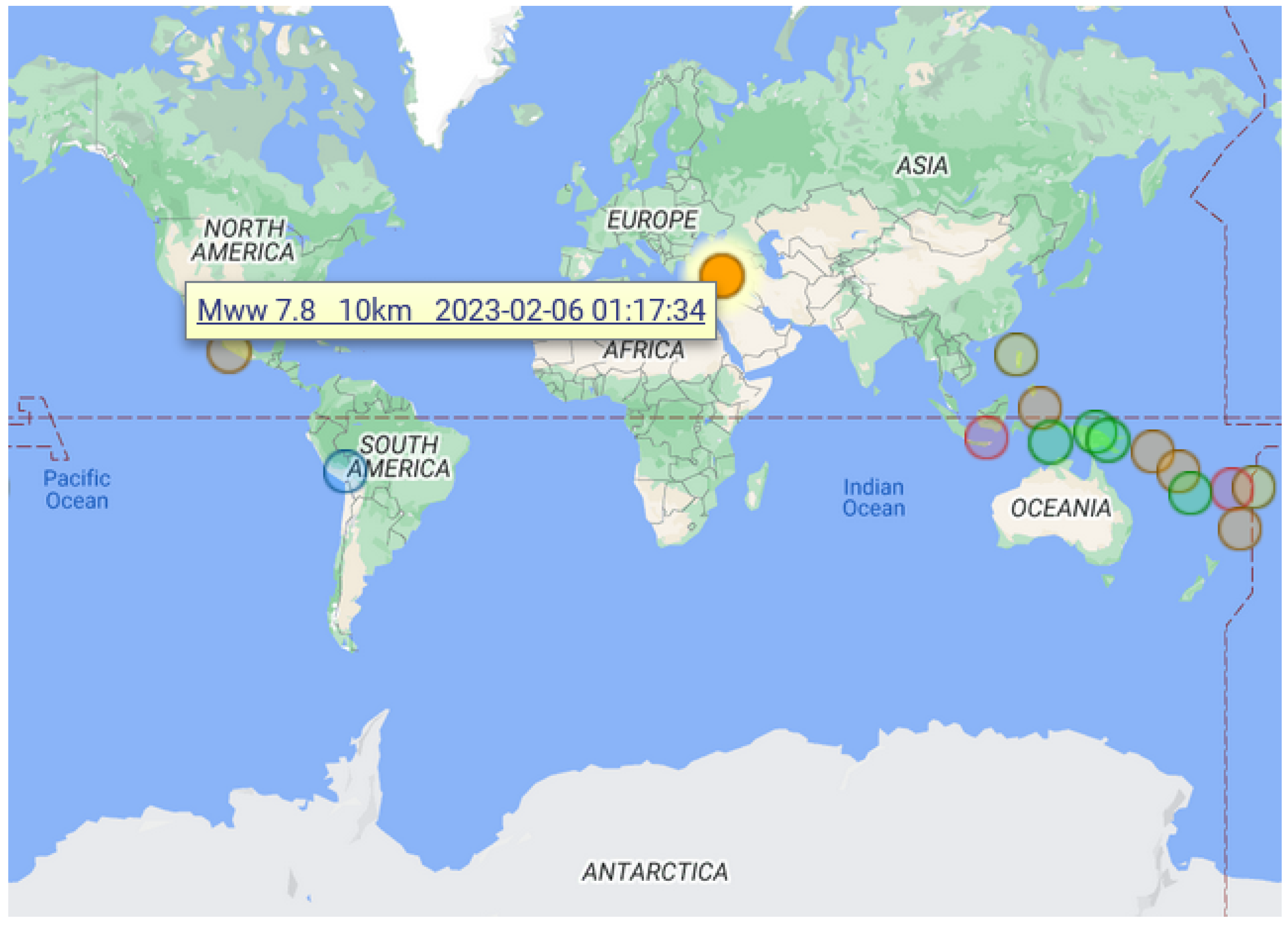
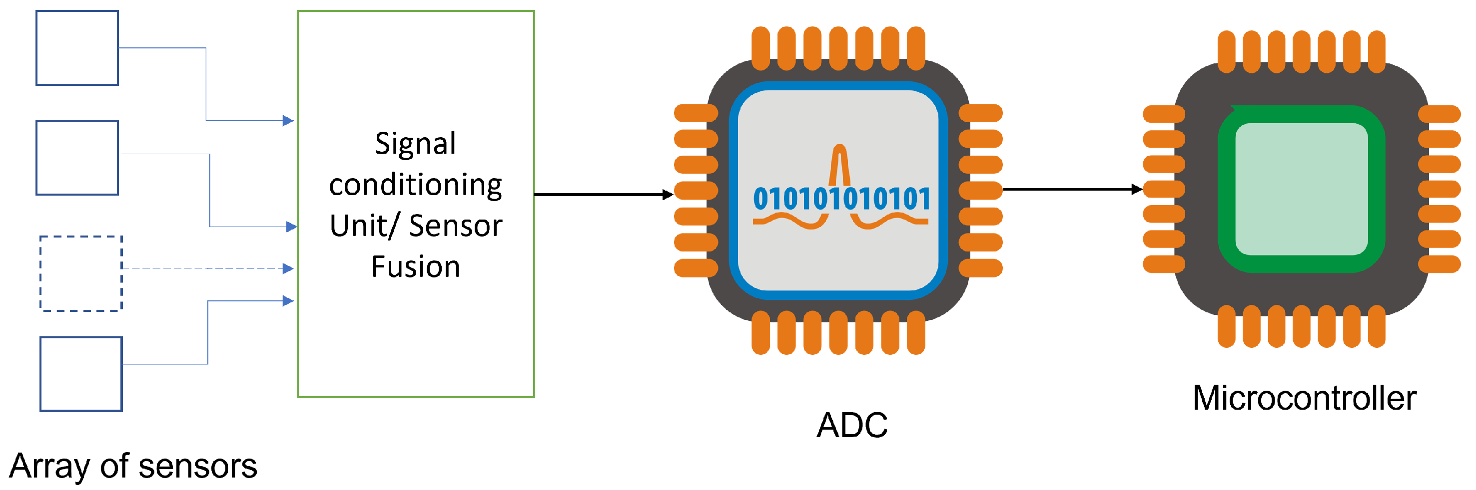
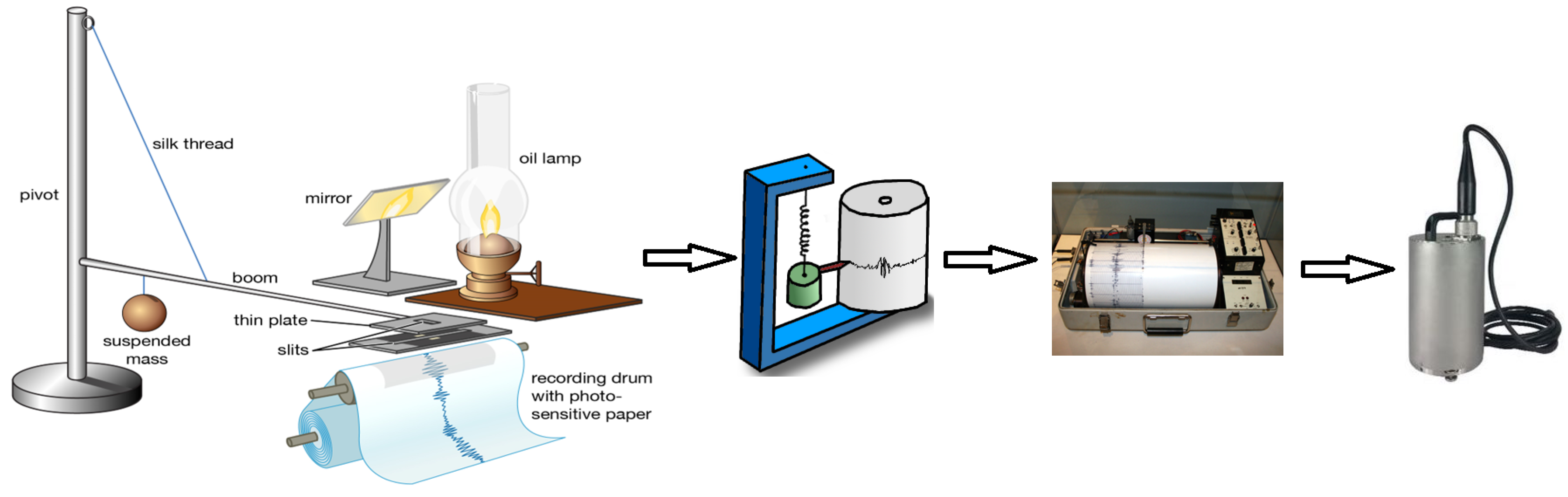
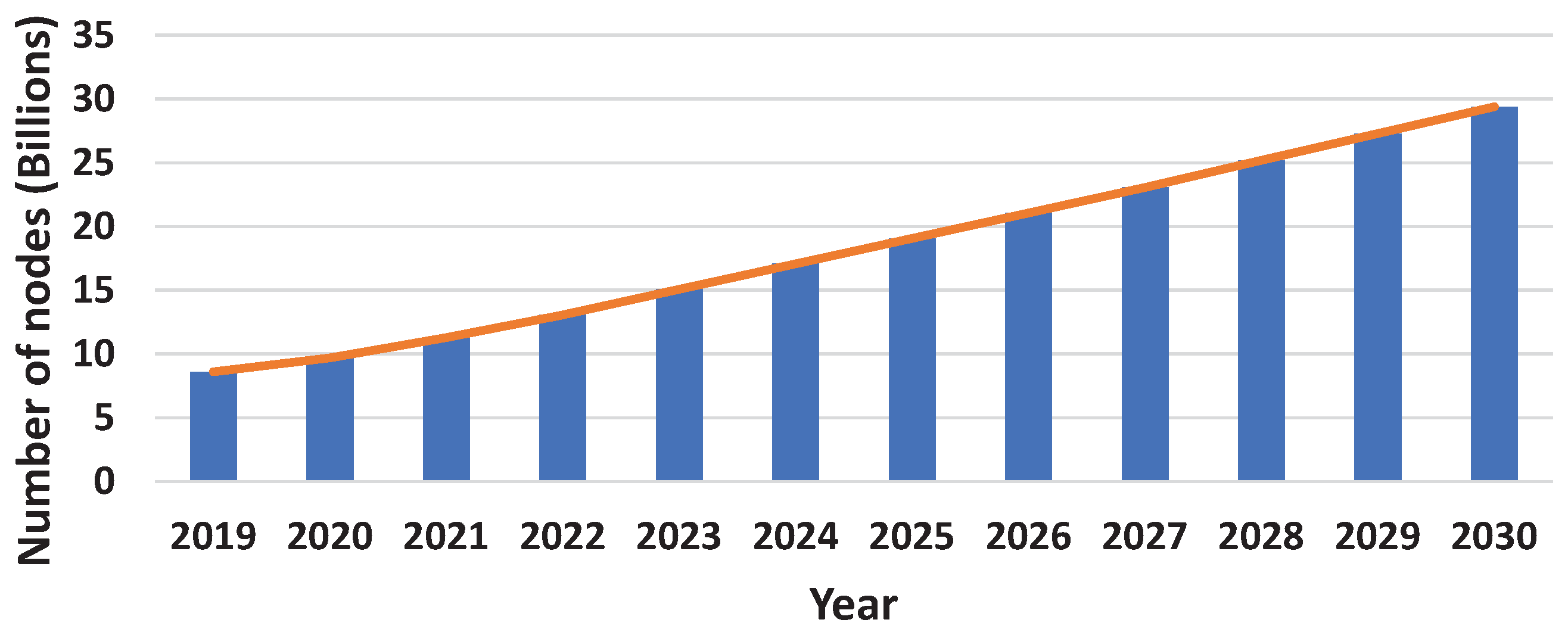
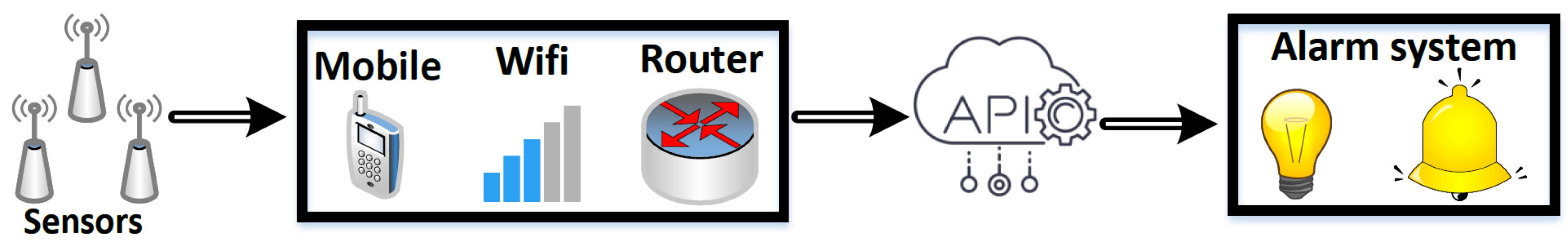
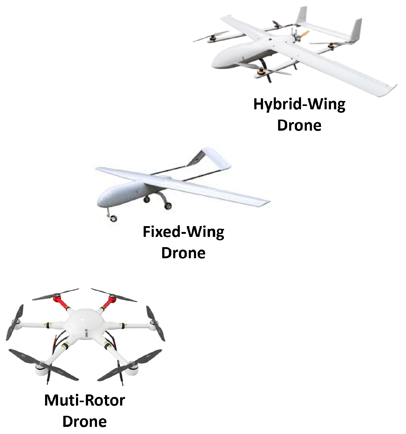
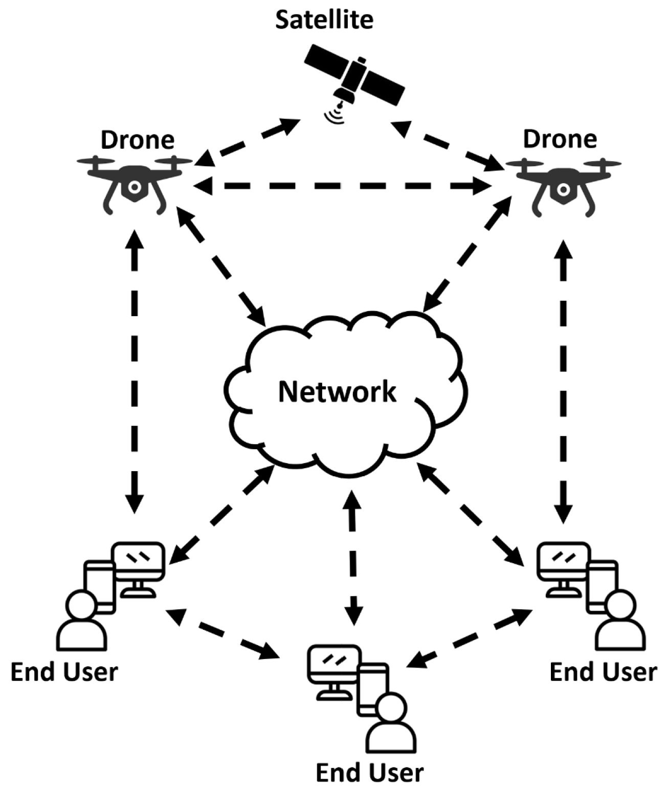
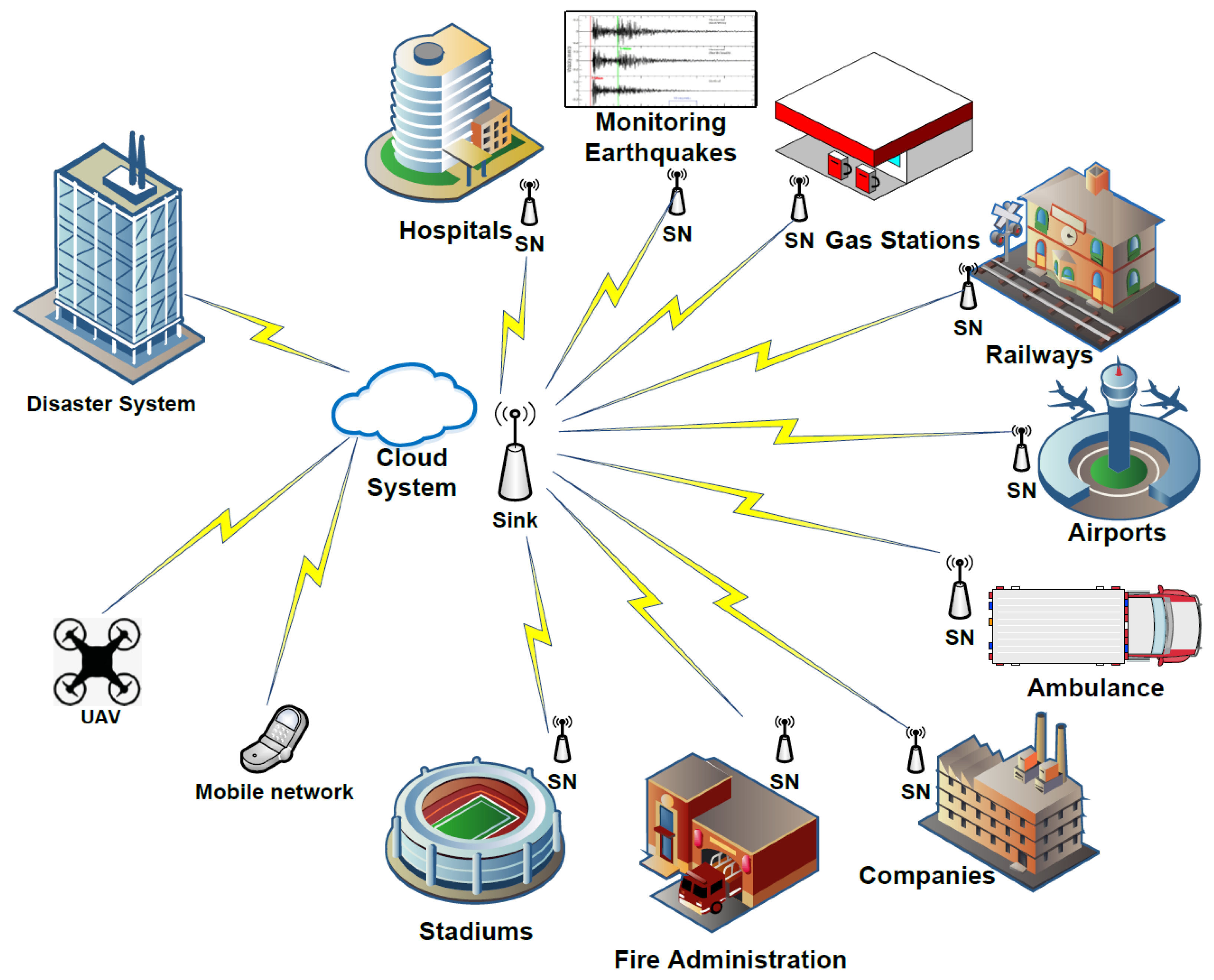
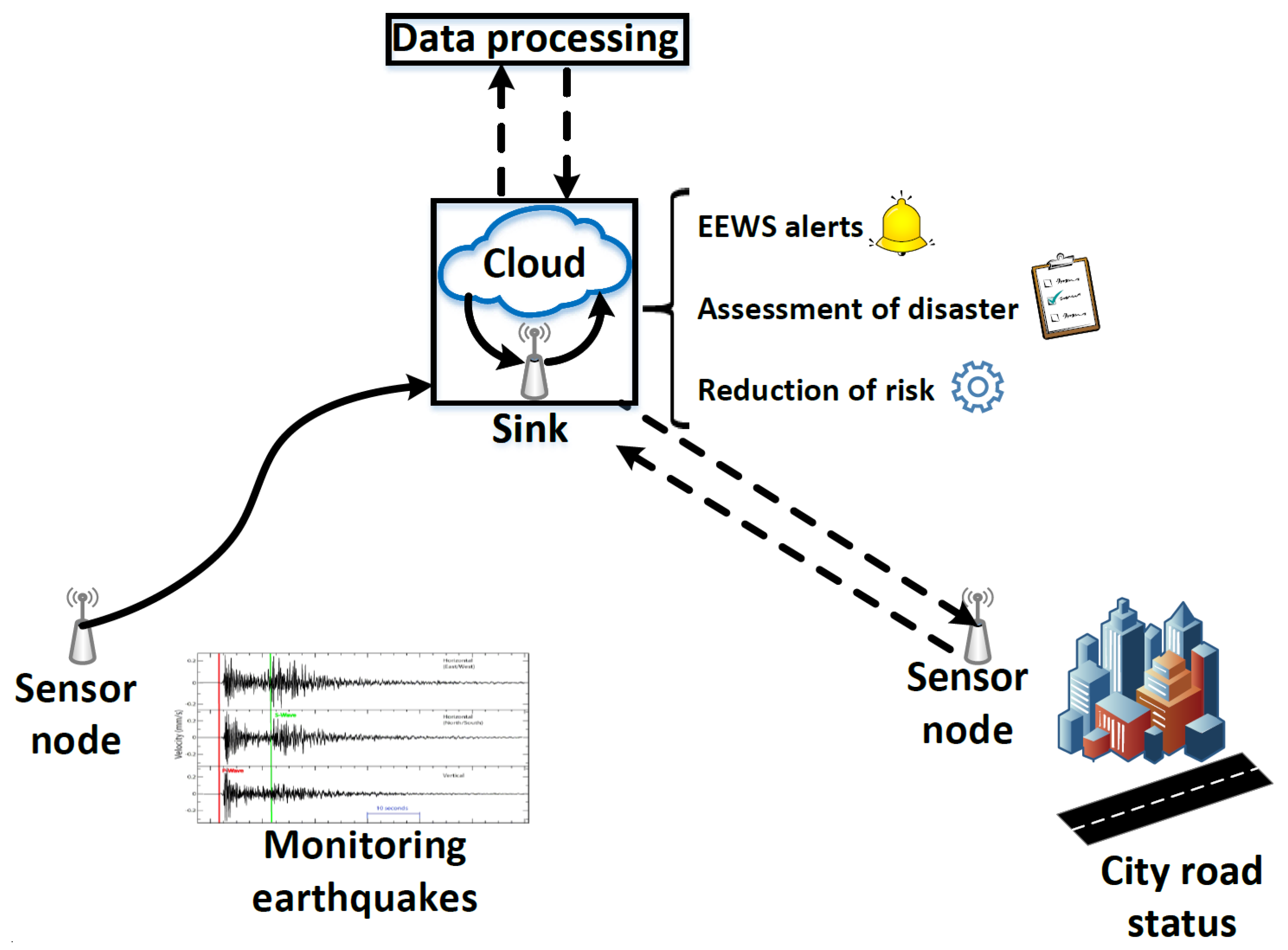
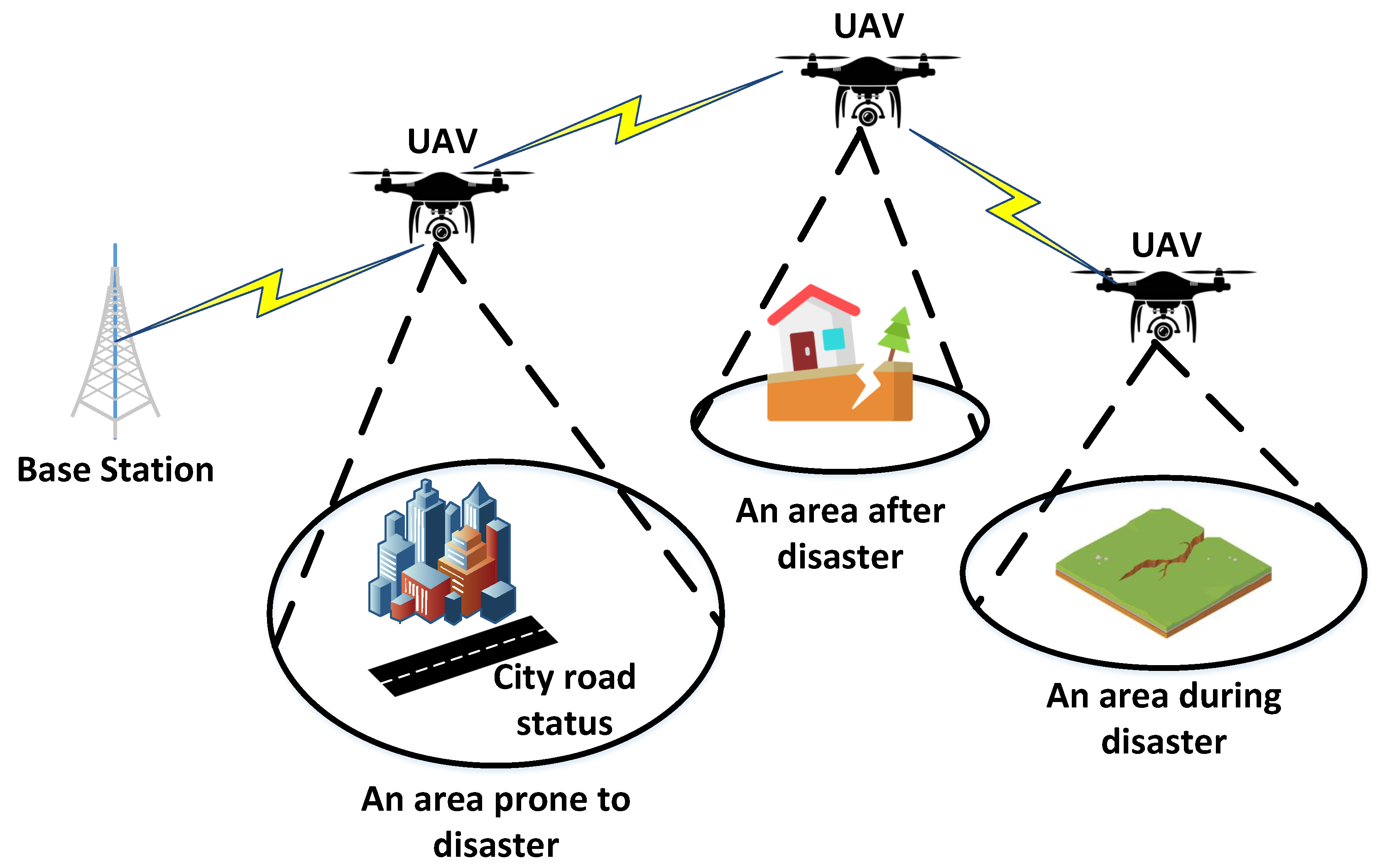
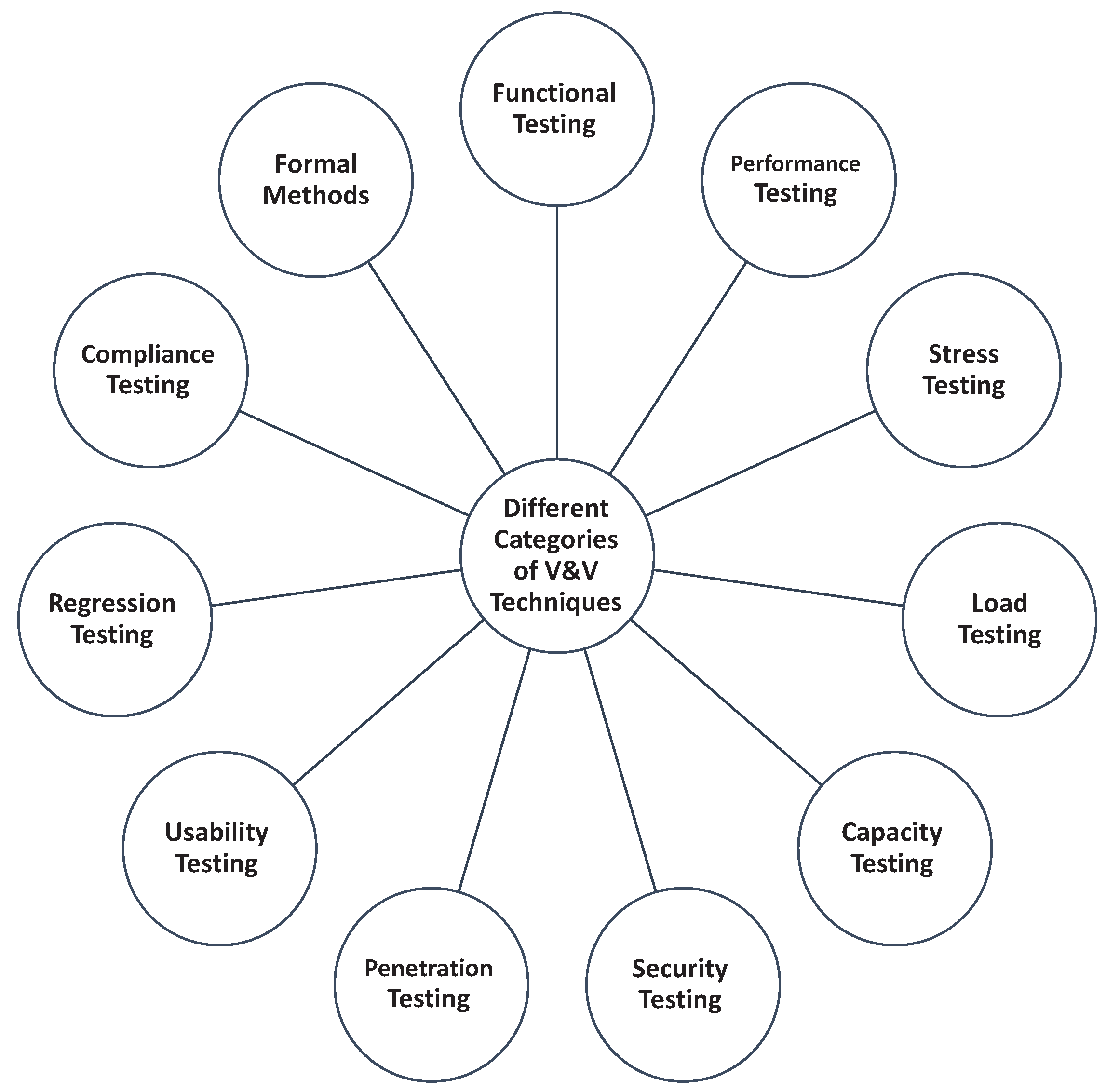
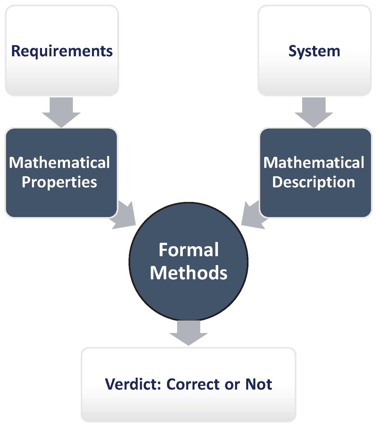
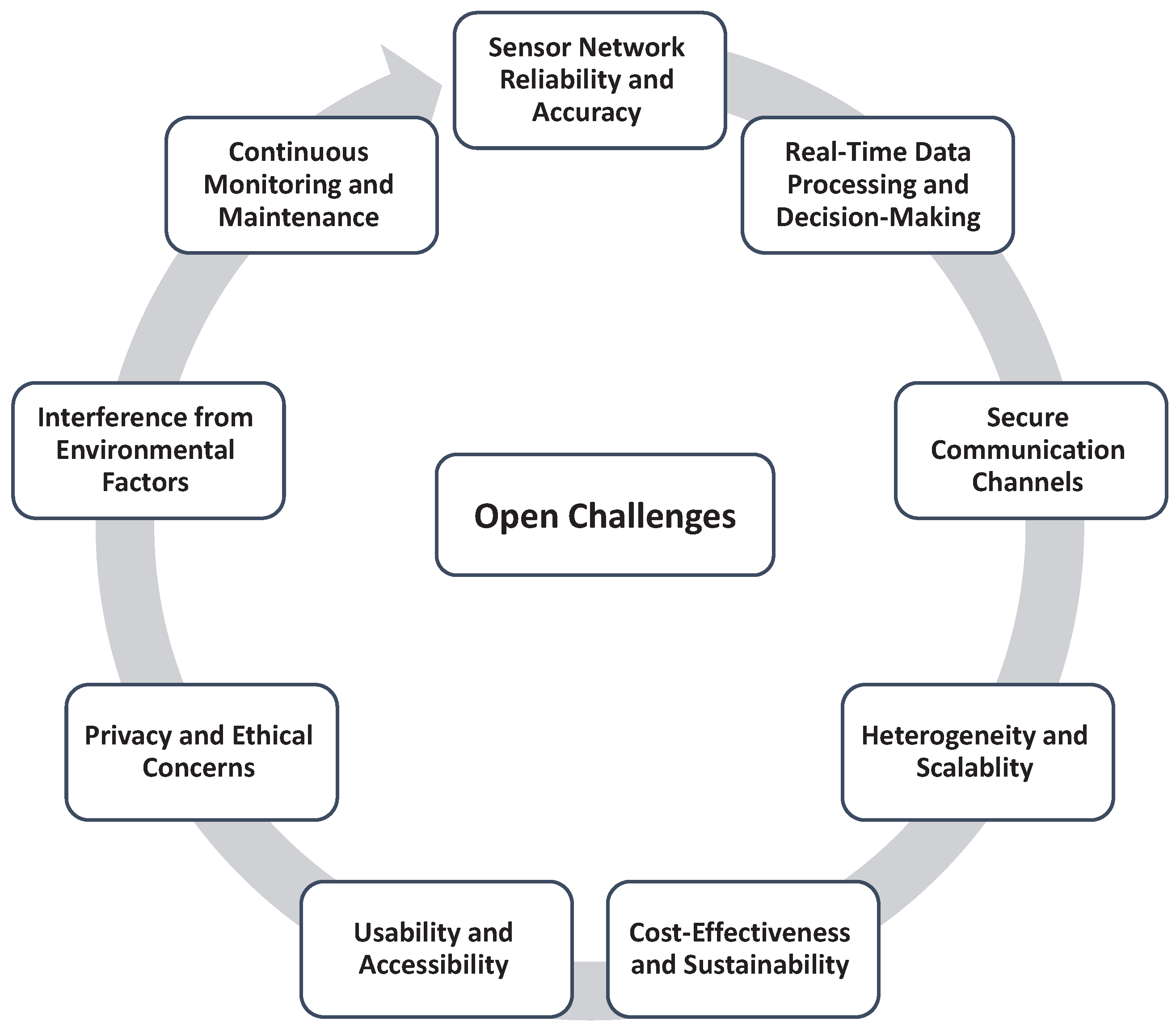
Table 1.
Comparison of our work with previous works.
| Ref. | Utilized Technology | Main Focus | Methodology | Contributions |
|---|---|---|---|---|
| [86] | Geophysical technology | Earthquake and catastrophe management | Literature review | Earthquake hazard, vulnerability, risk analysis |
| [87] | Remote sensing | Earthquake management | Review of remote sensing applications | Remote sensing pros and cons in earthquake research |
| [88] | UAV hardware | Disaster relief | Field trials and case studies | Implementable framework for drone data collection and analysis for disaster preparedness, response, and recovery |
| [89] | IoT technology | Disaster management | Comparative analysis of IoT-based disaster management options | Practical applications of IoT technology for disaster management |
| [90] | Modern technology | Disaster and risk management | Evaluation of available and applied technology | Suggestions for improving technology adoption across all DRM pillars |
| [91] | Mapping techniques | Mapping in post-earthquake settings | Evaluation of ML and deep learning frameworks | Identification of research gaps and possibilities for real-world scenarios |
| [92] | Remote sensing | Remote sensing data and methods for earthquake risk assessment | Review of remote sensing applications | Necessity for a complete, interdisciplinary approach to earthquake risk assessment |
| [93] | Satellite images | EEWS | Literature review | Evaluation of current and potential applications of remote sensing for seismic disaster early warning |
| [94] | Remote sensing | Post-earthquake damage assessment | Case studies and literature review | Identification of challenges and opportunities in remote sensing for post-earthquake damage assessment |
| [95] | Emerging technologies | Disaster management | Literature review and text mining | Analysis of the effects of emerging technologies on disaster management |
| [96] | Digital tools | Managing existing structures in earthquake settings | Case study | Procedure for managing pre- and post-earthquake stages of existing structure management using digital tools |
| Our Work | IoT nodes and cloud infrastructure | EEWS, environment type, data type, and source, measurement parameters, cloud infrastructure | Literature review and analysis | Comprehensive overview of the role of IoT and cloud infrastructure in EEWS, including a generic architecture and verification and validation methods |
Table 2.
Main Advantages and Limitations of Drones.
| Advantages | Limitations |
|---|---|
| Good performance in autonomous processes | Requirement of continuous connectivity with the controllers, network coordination |
| Long-distance flights, despite the need for line-of-sight, thus large coverage area | Range limitation proportional to the physical capabilities such as radio controller’s range, line-of-sight, and positioning |
| Transmission of big data to the cloud | Limited ability for intelligent data processing |
| Fast-deployed, flexible, and on-demand operative structure | Modeling complexity |
| Low-cost values | The necessity of Quality of Service optimization |
| Usage in dangerous areas | Security challenges such as hijacking |
Table 3.
IoT-based EEWS main efforts.
| Ref. | Sensor Node | Employed Environment | Used Data Type | Used Measurement Parameter | Source |
|---|---|---|---|---|---|
| [184] | Acceleration sensors (MMA8452, LIS3DHH, ADXL355, and MPU9250) | UG | Acceleration data | PGA | NIED and USGS |
| [180] | Mobile node | Coastal areas | Tsunamic data | Hypo-center and magnitude | NOAA |
| [177] | UAV nodes | ODLOS | Aerial images data | Received frames/sec | Local drones |
| [185] | Smartphones | S-D environment | Acceleration data | Earthquake data | NIED and USGS |
| [188] | Seismometer | UG | GPS and weak motion data | Earthquake data | IRIS and NIED |
| [173] | MEMS | UG | Acceleration data | Acceleration, SNR | NIED |
| [174] | Arduino Cortex M4 | UG | Acceleration data | Earthquake detection accuracy and detection latency | Local data observed by MEMS accelerometers |
| [175] | Acceleration nodes | IDNLOS | Acceleration data | PGA and human activity | Local distributed smartphones |
| [176] | Soil and terrain nodes | UG | Soil moisture, shear strength of the soil, severity of the rain | Soil moisture, Soil shear strength, rain severity | GSI |
| [53] | Tmote Sky | ID and OD | Seismic velocity data | Location and magnitude | JMA and Hi-net |
| [179,195] | IoT gateway | UG | Seismic waveform | Earthquake predictions | Local datasets and regional data |
| [183] | Acceleration nodes | UG | Acceleration data | PGA | NIED |
| [185] | MEMS | Noisy environments | Seismic waveform | P-wave arrival | STEAD |
| [182] | Raspberry Pi | Mesh network | Seismic waveform | Local earthquake | Locally observed |
| [196] | SSN/SOSA ontology | UW | Volcanic data | Volcano-tectonic, long-period earthquakes, underwater explosions, and quarry blasts | Local data |
Disclaimer/Publisher’s Note: The statements, opinions and data contained in all publications are solely those of the individual author(s) and contributor(s) and not of MDPI and/or the editor(s). MDPI and/or the editor(s) disclaim responsibility for any injury to people or property resulting from any ideas, methods, instructions or products referred to in the content. |
© 2023 by the authors. Licensee MDPI, Basel, Switzerland. This article is an open access article distributed under the terms and conditions of the Creative Commons Attribution (CC BY) license (https://creativecommons.org/licenses/by/4.0/).
Share and Cite
MDPI and ACS Style
Abdalzaher, M.S.; Krichen, M.; Yiltas-Kaplan, D.; Ben Dhaou, I.; Adoni, W.Y.H. Early Detection of Earthquakes Using IoT and Cloud Infrastructure: A Survey. Sustainability 2023, 15, 11713. https://doi.org/10.3390/su151511713
AMA Style
Abdalzaher MS, Krichen M, Yiltas-Kaplan D, Ben Dhaou I, Adoni WYH. Early Detection of Earthquakes Using IoT and Cloud Infrastructure: A Survey. Sustainability. 2023; 15(15):11713. https://doi.org/10.3390/su151511713
Chicago/Turabian StyleAbdalzaher, Mohamed S., Moez Krichen, Derya Yiltas-Kaplan, Imed Ben Dhaou, and Wilfried Yves Hamilton Adoni. 2023. "Early Detection of Earthquakes Using IoT and Cloud Infrastructure: A Survey" Sustainability 15, no. 15: 11713. https://doi.org/10.3390/su151511713
Note that from the first issue of 2016, this journal uses article numbers instead of page numbers. See further details here.