


Vietnam’s Water Resources: Current Status, Challenges, and Security Perspective

1
Faculty of Water Resources, Hanoi University of Natural Resources and Environment, Hanoi 100000, Vietnam
2
National Center for Water Resources Planning and Investigation, Hanoi 100000, Vietnam
*
Author to whom correspondence should be addressed.
Sustainability 2023, 15(8), 6441; https://doi.org/10.3390/su15086441
Submission received: 19 January 2023
/
Revised: 28 March 2023
/
Accepted: 6 April 2023
/
Published: 10 April 2023
(This article belongs to the Special Issue Sustainability in Water Supply and Smart Water Systems)
Abstract
:The current status of the exploitation, use, and management of water resources in the context of socioeconomic development, climate change, and issues related to the region are causing negative impacts on the water resources of Vietnam. This study aimed to develop a framework for assessing Vietnam’s water security based on the following key aspects: (i) the availability of water resources; (ii) the current status of water exploitation and use; (iii) the current status of waste water and water pollution; (iv) water resource management organization; and (v) water-related disasters, including floods, droughts, subsidence, coastal erosion, landslides, ecological imbalance, and diseases related to water resources. In particular, the challenges of transboundary water resources and the food–energy–water nexus were investigated. We reviewed the assessment frameworks that have recently been developed outside Vietnam or regions with similar climates and analyzed the characteristics of downstream and rapid-growth countries such as Vietnam using a number of key water resource indicators, both qualitative and quantitative. From these processes, we developed an assessment framework and provided a perspective on water security. The results of this study showed that the challenge of transboundary water resources, the impact of climate change, the pressure on socioeconomic development, and the water–energy–food nexus are core issues that need to be addressed from the perspective of water security in Vietnam. This case study may be helpful for downstream and developing countries.
1. Introduction
Depending on the perspective of research on water use (to meet basic human needs or for environmental activities), there are different definitions of water security [1,2,3]. All of these studies refer to a community’s ability to access reliable water resources and cover the following basic goals: (i) ensuring that the basic needs of human life are met by adequate access to water of an acceptable quantity and quality; (ii) protecting the environment and ecosystems against the dangers of disasters related to water; (iii) promoting sustainable development. The United Nations Water Commission [3] defines water security as “the ability of a community to maintain sustainable access to sufficient quantities of water of acceptable quality to sustain livelihoods, human health, and socio-economic development, ensuring against waterborne pollution and water-related disasters, conserving ecosystems in an environment of peace and political stability”. Several studies on water security assessment have been conducted outside of Vietnam and regions with similar climates. A water security assessment framework based on five aspects to assess China’s water security was developed, and it pointed out that China is currently facing a scarcity of water resources [4]. Water demand is increasing, seriously threatening the socioeconomic and sustainable development of this country. Integrated water resource management (IWRM) was used as a tool to strengthen institutions, policies, and legislation to address Libya’s food and energy security issues [5], as well as those of Finland [6]. The role of governance in enhancing water security for the benefit of people and nature was assessed, and recommendations were put forward in [7]. An evaluation of the economic potential in cases of increased water storage benefiting farms and food security was conducted based on an integrated water resources management framework in the face of highly fluctuating water supplies in the Balkh basin, Afghanistan in [8]. Reviews of indicators and methods of assessing water scarcity have been presented, considering indicators such as: (i) a group of indicators based on human water requirements, determined based on Falkenmark’s index [9], which is the most commonly used index to assess water stress status; (ii) a group of water resource vulnerability indicators based on the relative local water use and reuse index, river basin sustainability index, water supply stress index, and physical and economic water scarcity; and (iii) a group of indicators that combine water and environmental requirements [10].
Vietnam is located in southeast Asia, a tropical region with intensive rain. The average annual rainfall [11] and the river discharge are large compared to data presented in global studies [12], implying that this country is rich in water resources (Figure 1 and Tables S1–S3) [13,14]. The precipitation varies greatly across space and time. In the period 1980–2020, the average annual rainfall was about 1990 mm. It varied quite widely across the country, from 500–600 mm in the coastal and driest areas of Ninh Thuan and Binh Thuan to over 4000–5000 mm in some high mountainous areas such as the Nam Chau Linh mountainous area (Quang Ninh) and the Chay river arch (Ha Giang). Vietnam has 106 river basins with about 3450 rivers and streams that are relatively large (length of 10 km or more). There are 10 major river systems with a basin area larger than 10,000 km2, including the Red–Thai Binh, Bang Giang–Ky Cung, Ma, Ca, Vu Gia–Thu Bon, Ba, Se San, Srepok, Dong Nai, and Mekong Rivers. Most rivers and streams flow in a northwest–southeast direction and then reach the East Sea. Of the 10 major river systems, 7 are river systems with international rivers. Four river systems—Red–Thai Binh, Ma, Ca, and Cuu Long—are downstream and receive water from outside the country, while three river systems—Bang Giang–Ky Cung, Sesan, and Srepok—are upstream, and the water flows out of the country. The total amount of surface water resources nationwide is 844.4 billion m3, of which 97% is mainly concentrated in river basins: Bang Giang–Ky Cung, Hong–Thai Binh, Ma, Ca, Huong, Vu Gia–Thu Bon, Tra Khuc, Kon–Ha Thanh, Ba, Se San, Srepok, Dong Nai, Cuu Long, Cai Ninh Hoa, Cai Nha Trang, the group of Quang Ninh river basins, the group of Quang Binh river basins, the group of Quang Tri river basins, and the group of southeast river basins. A minor percentage is distributed in small independent coastal river basins [13]. The aquifer system with the most potential is concentrated in two large deltas, the Red River Delta and the Mekong River Delta, and the Central Highlands [14]. However, problems of saltwater intrusion and subsidence related to groundwater exploitation are occurring in unconsolidated and semi-unconsolidated aquifers in the two deltas [13]. While depletion and pollution has occurred in basaltic aquifers in the Central Highlands over the past three decades, Vietnam’s economy has grown rapidly, with an annual GDP growth rate of nearly 7%. This, in addition to the policies to ensure food security, energy security, and water security, has caused many challenges and contradictions for local water security. Therefore, in recent decades, water security has become a serious problem in terms of the exploitation, use, and management of water resources, and this issue has been mentioned in a number of research publications and reports [3,13,14,15].
Several challenges related to water security have been mentioned in the context of Vietnam, including the following [16]: (i) about 60% of river flow discharge is from outside Vietnam, (ii) natural disasters and climate change have been threatening water resources, (iii) water resources are at risk of serious deterioration not only in quantity but also in water quality, and (iv) the water demand is increasing rapidly due to socioeconomic development and population increases in association with the need to improve the quality of life. Furthermore, River Basin Management Councils and the Environmental Protection Committee for River Basin Organizations (RBOs) were established under the provisions of the Law on Water Resources in 1998. Although RBOs have been established in a number of large river basins, the role of local governments in these organizations and the financing mechanisms are unclear, so River Basin Management Boards (MBMs) have not operated effectively [17]. In recent years, the COVID-19 pandemic has also affected water intake, and water pressure changes were observed during that period [18,19,20]. Additionally, Vietnam is a tropical country that has suffered from several unforeseen problems such as the pandemic and the outbreak of diseases, including water-related diseases, so this problem needs to be considered.
In their research on “Measuring global water security towards sustainable development goals”, Gain et al. (2016) [21] assessed water security at a global scale on the basis of four criteria: availability, accessibility of services, safety and quality, and management. Data on a monthly temporal scale from the global hydrologic model PCR-GLOBWB and physical and socioeconomic dimensions were used in this assessment. The authors also documented that the aggregated global water security index (GWSI) in Vietnam ranged from 0.38 to 0.44, not yet reaching the average level of water security [21]. Thus, are climate change and socioeconomic development the main causes of this low water security assessment? These factors are important, but they are not enough. Emerging challenges that are having a huge impact on water security in Vietnam are heavily influenced by transboundary water sources, as it is a downstream country. Moreover, Vietnam is also a developing country with a fast-growing economy and has continued to be over the past 20 years, and so it requires not only traditional but also nontraditional security measures [16,22]. Traditional security can be defined as keeping a territory or state safe from military activities, while nontraditional security is based on threats to the “survival and well-being” of a community or state that arise mainly from nonmilitary sources [23]. This means that solving the food–energy–water nexus for sustainable development is not an easy issue. Water resource governance is also an issue that needs to be addressed before solving the abovementioned problems [15,17,24]. Nationally, previous studies have shown that the research on water security in Vietnam is at an early stage and has not been afforded due attention, and these challenges have not been deeply addressed [15,16,17]. Internationally, studies have not yet generalized the core of the challenges mentioned in this study [3,4,5,6]. There are many questions to raise during water security assessment, such as “What is the current status of water resources in Vietnam?”, “What emerging challenges need to be clarified for water security assessment in Vietnam as a downstream and developing country?”, and “How will the prospects for water security in Vietnam improve?”. Therefore, this study aimed to develop a framework for assessing Vietnam’s water security based on the following key aspects: (i) the availability of water resources; (ii) the current status of water exploitation and use; (iii) the current status of wastewater and water pollution; (iv) water resource management organization; (v) water-related disasters including floods, droughts, subsidence, coastal erosion, landslides, ecological imbalance, and diseases related to water resources; and, in particular, the challenge of transboundary water resources and the food–energy–water nexus, which are also mentioned. This case study may be helpful for other downstream and developing countries.
This paper comprises the following sections. In Section 1, we review the existing water security frameworks that relate to Vietnam and the key issues that should be addressed. Section 2 presents the current status of water resources in Vietnam. In Section 3, we analyze the emerging challenges to water security that pertain to downstream and developing countries such as Vietnam. In Section 4, based on the current state of national water resources and related challenges, we examine the water security perspective, which is crucial for future water security in Vietnam. In Section 5, we discuss the suggested framework and the perspective on water security for Vietnam, and Section 6 concludes the paper.
2. Current Status of Water Resources in Vietnam
2.1. Availability of Water Resources
2.1.1. Rainwater Resources
The average annual rainfall in the period 1980–2020 across the whole territory was about 1990 mm, equivalent to about 640 billion m3/year. It was unevenly distributed across river basins and seasons. The Thu Bon–Vu Gia Basin had the largest average annual rainfall of 2700 mm, followed by the Huong and Tra Khuc Basins with an average annual rainfall of 2600 and 2650 mm, respectively. The Kone Basin, Dong Nai Basin, Cai Nha Trang Basin (Nha Trang RG), Quang Binh river basin group (Quang Binh RG), and Quang Tri river basin group (Quang Tri RG) had an average annual rainfall in the range of 2100 to 2400 mm. The smallest average annual rainfall existed in the river basin group in southeast Vietnam (SERG), in the range of 1280 to 1310 mm. The distribution of basin area and average annual rainfall in the river basins for the period 1980–2020 is presented in Figure 1 and Figure 2 and Tables S1–S3 [14,15].
2.1.2. Surface Water Resources
Surface water resources in Vietnam are determined on the basis of the total surface flow of river basins nationwide. The surface water resources of each river basin are formed from water sources inside and outside the territory. Indicators of the total average annual and dry season surface water discharge present the level of water stress in river basins [9,25].
The total average annual discharge from all basins in Vietnam is 844.4 billion m3, of which 97% mainly originates from the following river basins: Bang Giang–Ky Cung; Red–Thai Binh; Ma, Ca, Huong; Vu Gia–Thu Bon; Tra Khuc, Kon–Ha Thanh; Ba; Se San; Srepok; Dong Nai; Cuu Long (Vietnam Mekong); Cai Ninh Hoa; Cai Nha Trang; and the river basin groups in Quang Ninh, Quang Binh, Quang Tri, and southeast Vietnam. A minor percentage is distributed in the small independent river basin group on the central coast [14,15].
Figure 3 represents the total average annual discharge originating from basins inside and outside Vietnam in the period 1980–2020. It was unevenly spatially distributed across river basins, regions, and seasons (Figure 3 and Tables S3 and S4), and the flow separated into two distinct seasons, the wet and the dry season, depending on the basin topography and geography. The flow discharge from all basins in the wet season accounted for 60–80% of the total average annual discharge, while the dry season flow accounted for only 20–40%. In the driest month, the flow only accounted for about 1.1–3.4% of the total average annual discharge.
Considering only the total average annual discharge from all basins in Vietnam, the amount of water per capita per year is very large (>9800 m3/capita/year) [14,15]. However, regarding more specifically the total average annual discharge by river basin and by season, many river basins in different seasons suffered from water shortages, sometimes severe, according to the most widely used measures of water stress [9]—the Falkenmark indicator and its thresholds. These are based on basic human water needs and surface water runoff sources and directly relate water stress status to population size [9]. According to this indicator, an adequate water availability per capita per year is 4000 m3, and irregular or local water shortages are represented by a water availability of between 1700 m3 and 4000 m3. For severe water stress, the indicator for water scarcity has a water availability in the range of 500 and 1000 m3, while the indicator for a threat to life or absolute scarcity is less than 500 m3 [9]. Due to data constraints, the total average annual and dry season surface water discharge were applied to consider the water stress in the basins. We are also aware that these figures may not provide an accurate picture of the overall water availability in a basin, but they are acceptable because surface water is a dominant source of water availability. Figure 4 represents the annual water availability indicator in each basin, which is the average annual surface water discharge from the basin divided by the population of that basin. This figure indicates the relative abundance of surface water resources for the populations of all basins except the Kone, Dong Nai, and Serepok Basins, which have flow discharges close to 4000 m3/capita/year, slightly below the adequate water level [13]. Similarly, Figure 5 represents the dry season surface water discharge of the basins divided by the population. This indicator shows that, at the current levels of development and in the dry season, many river basins across the country are likely to experience irregular or local water shortages [13]. During the dry season, only two basins had adequate water to support their communities (Cuu Long and Se San), and, based on the standard, another six basins (the Bang Giang–Ky Cung, Thu Bon–Vu Gia, Ba, and Cai Nha Trang, Quang Binh RG, and SERG Basins) were unlikely to experience water shortages. In the remaining basins, all but the Quang Ninh RG and Dong Nai Basins could experience irregular or local water shortages.
2.1.3. Groundwater Resources
The results of compiling and re-evaluating the groundwater potential, which is the dynamic reserve (or recharge) for the nation’s aquifers, determined through the project “Compiling a map of groundwater resources at the scale of 1:200,000 for provinces nationwide” [26] showed that the groundwater resource potential is quite large, with total estimated groundwater resources of about 91.5 billion m3/year (freshwater about 69.1 billion m3/year, saltwater about 22.4 billion m3/year). Within this figure, the total exploitable freshwater groundwater potential, i.e., via sustainable use, is about 22.3 billion m3/year. The distribution of the groundwater resource potential and exploitable groundwater potential in the river basins is represented in Figure 6a,b and Table S5.
2.2. Water Demand, Exploitation, and Use
2.2.1. Water Demand
According to the estimation of water demand for the National Master Plan for Water Resources in the period 2021–2030 with a vision to 2050 [13], the total annual water demand of all sectors is currently about 117.03 billion m3/year (accounting for about 12.5% of the total average annual water discharge from all basins nationwide). Within this, the water demand for agriculture is about 78 billion m3/year, accounting for about 73.1%; the demand for aquaculture is about 16.35 billion m3/year, accounting for about 15.3%; and the demand for industry is about 8.8 billion m3/year, accounting for 8.3%. The specific figures for water demand in the river basins for the years 2022, 2025, 2030, and 2050 are presented in Table 1.
2.2.2. Water Exploitation and Use
According to statistics from 2015, the total volume of water exploited and used nationwide was estimated at 80.2 billion m3/year, of which surface water represented about 77.2 billion m3 (accounting for 96.3% of the total water volume exploited and used), while the amount of groundwater exploited and used was only about 2.97 billion m3/year (accounting for 3.7% of the total water volume exploited and used) (Table S6).
The total annual volume of groundwater exploited and used nationwide was about 2.97 billion m3/year, equivalent to about 8,133,845 m3/day. Regarding the proportion of water use by sectors in 2020, there was an increase in the amount of water used for industry compared to 2015, with a particularly large increase in the river basins of Quang Ninh, Ca, Ba, Dong Nai, and the central coast.
The international standard for water exploitation stress dictates that moderate stress begins at an indicator value of 20%, and high water stress is represented by indicator values above 40% [27]. Figure 7 shows that only the Dong Nai, Cai Ninh Hoa, and SERG Basins were in the moderate stress range, and the Red–Thai Binh Basin was nearing this range. On an annual basis, all other rivers were at low stress levels. Nationally, the water demand represented almost 10% of the total average annual surface water discharge. Note that the direct investigation of water use has generally not yet been carried out, so the figures used were water demand estimates.
2.3. Current Status of Wastewater and Water Pollution
2.3.1. Pollution Sources and Vulnerability to Water Pollution
The degradation and pollution of the water environment in river basins occur for many different reasons, with the primary cause being the disposal of wastewater into rivers and streams. Sources for water degradation and pollution mainly include domestic waste, industry, agriculture, craft villages, healthcare, and a large amount of uncontrolled solid waste. In particular, the amount of domestic and agricultural wastewater, including aquaculture and industry, still accounts for the largest proportion of wastewater generated and discharged into water sources [28].
Although domestic wastewater accounts for more than 30% of the total amount of wastewater directly discharged into the environment, the levels of collection and treatment are still very low. About 7,680,000 m3/day of domestic wastewater is generated from urban areas in fourth-rank or larger cities, for which there are centralized wastewater treatment systems that have reached a wastewater collection rate of 21.35%. The average rate of wastewater collection and treatment in urban areas nationwide is about 12.5%. Thus, a large amount of untreated urban wastewater is discharged directly into river sections flowing through cities and urban areas, causing local overload in rivers, seriously reducing water quality [28].
Currently, there are more than 300 industrial zones in operation, with the total amount of wastewater discharge being about 510,000 m3/day nationwide. The proportion of centralized wastewater treatment systems with qualifying environmental technical standards is 89%. In cities or provinces with a large number of industrial zones, such as Ho Chi Minh City, Hanoi, Binh Duong, Ba Ria–Vung Tau, Dong Nai, Long An, Quang Ninh, and Bac Ninh, the rates have all reached 100% [29].
Water pollution from irrigation systems and the agricultural sector is also a great concern, as detailed below [30]:
- -
- The solid waste and wastewater discharged into irrigation systems are increasing, especially untreated domestic wastewater discharged directly into irrigation systems;
- -
- The abuse of fertilizers, chemicals, and pesticides in agricultural production;
- -
- Water shortages: the water level drops in the dry season in many river systems have tended to increase in recent years, which is also one of the causes of more severe water pollution;
- -
- The operating procedures for irrigation are usually set up for the main river systems, not taking into account the operation of wastewater drainage systems to reduce water pollution.
2.3.2. Pollution of Surface Water
In order to assess water quality in the period 2016–2020, the Vietnam Environment Protection Agency (VNEPA) under the Ministry of Natural Resources and Environment (MONRE) took samples from 1070 locations in monitoring networks (7 national monitoring stations for surface water and 1063 monitoring provincial stations). The analyzed parameters were mainly DO, TSS, COD, BOD5, NO2−, NO3−, NH4+, and PO43− [28]. The assessment of the water quality index (WQI) was conducted on the basis of the analyzed results and the national technical regulations for surface water quality in terms of pollution indicators [28]. The results of the water quality assessment for the river basins are represented in Figure 8. In general, most of the surface water in the large basins such as the Red–Thai Binh, Ma, Vu Gia–Thu Bon, and Mekong Basins was assessed as “Good” to “Average”. However, there were still some areas where the surface water was polluted, mainly in rivers that flow through areas with strong urbanization and industrialization. The water pollution in the basins is mainly organic and nutrient pollution from domestic waste, industry, agricultural wastes, craft villages, healthcare, and solid waste. Most of the monitoring points have not yet recorded any signs of pesticide contamination. Agricultural pollution is also a real challenge due to its solute transport, nonpoint pollution source, and the trade-off between ensuring food security by increasing the cultivation area of paddy fields and improving water quality. In addition, water pollution from craft villages in rural areas and grease and heavy metal pollution from navigation activities, industrial operations, and mining activities occur locally.
2.3.3. Groundwater Pollution
Arsenic pollution has a major impact on water quality and human health. The pollution of arsenic, Pb, and Mn in porous aquifers has exceeded the allowable standards many times in the Red–Thai Binh Delta and some areas in the Vietnam Mekong Delta [31,32,33,34]. Microbial pollution is a major problem occurring in porous aquifers, especially in densely populated areas and areas of fast socioeconomic development, where wastewater is directly and indirectly discharged and allowed to pollute both shallow and deep aquifers, such as in the Red–Thai Binh, Dong Nai, and Vietnam Mekong Basins [14,35,36,37,38].
2.3.4. The Problem of Saltwater Intrusion
In addition to the problems of water quality pollution mentioned above, saltwater intrusion is also one of the causes of water quality deterioration. At present, saline intrusion continues and tends to increase in the estuaries of the coastal plains. In the southern plain (the Dong Nai and Vietnam Mekong Basins), saline intrusion is quite complicated. In some coastal areas, seawater has penetrated deep into rivers and canals, causing saline intrusion from surface water, leading to saline intrusion into groundwater, which tends to increase in some shallow aquifers [39,40,41].
2.4. Actual Situation of Organization and Management of Water Resources
The legal documents related to water resource management were formed according to a system of laws; guiding documents based on laws, especially the Law on Water Resources; and documents detailing and guiding the implementation of the law. In addition, the management of water resources is also carried out in accordance with relevant specialized laws, such as the Law on Environmental Protection and the Law on Irrigation, and is governed by other legal regulations such as the Law on Planning, the Law on Fisheries, and the Law on Natural Disaster Prevention and Control. The national management agencies for water resources and their main functions are presented in Figure 9 [15,24].
- Advisory role to the government for decisions on water resources;
- Organizing discussions among specialists;
- Recommendations on national water resources;
- Solving conflicts between ministries and provinces.
The function of River Basin Organizations (RBOs):
- Recognized in the Law on Water Resources as a mechanism for water and related resources planning and management;
- Responsible for developing integrated RBOs, whilst taking various stakeholders into account;
- Coordinate ministries, agencies, and provincial water-related activities;
- Coordinate water resource assessment and monitoring;
- Advise government on the resolution of water-related disputes within river basins.
As early as 2008, the ADB report on the Socialist Republic of Viet Nam: Water Sector Review documented that the application of integrated principles in Agenda 21 in Vietnam was still limited [15]. This statement is still true, in that: (i) the integration of water resource management into programs has not been correctly implemented; (ii) insufficient attention has been paid to the concept of water as a part of an integrated ecosystem in the management of water resources, and water has not been considered as an economic good; (iii) currently, water use is often associated with the interests of a certain localities or industries to meet specific goals—to increase responsibility, the right to water should be assigned to developers of water resources; (iv) the national strategy on water resources identifies the fact that the combination of land use and impact assessment in water ecosystems in Vietnam is still very limited; (v) the current Law on Water Resources does not fully represent regulations related to IWRM; (vi) the management function of river basin organizations (RBOs) is still a problem and has not yet realized the essence of IWRM; (vii) currently, water service providers are afforded very little autonomy by the nation and have little opportunity to increase their water business rates to ensure financial stability; (viii) the effective participation of communities and water users in (the implementation of) decisions on water resources is not sufficient, although there is a legal framework for participation at all levels; (ix) Vietnam’s water resources depend greatly on international river basins. Currently, international cooperation in the Mekong River Basin under the Mekong Agreement is well underway [42], but institutional strengthening in this area is still needed, and many international river basins, including the Red River Basin (shared with China), do not yet have a formal cooperative mechanism.
Vietnam is applying IWRM principles fairly quickly to respond to water resource issues and to achieve economic, social, and environmental goals according to an integrated asymptotic approach. To carry out this task, it is necessary to significantly change the state of management today, because the previous and current conceptions of management will no longer be relevant in the future.
2.5. Water-Related Disasters
2.5.1. Flooding
In the period 2017–2020, Vietnam suffered heavy damage due to the effects of floods and inundation. This situation often appears after storms hit the country. River basins in the central region have been most affected by the big storms that occur continuously in the months of the flooding season. For example, in 2020, unusually heavy rain fell on a large scale and lasted for a long time in central Vietnam, which caused abundant damage in the region [14,43].
2.5.2. Drought and Saltwater Intrusion
Drought and saltwater intrusion are considered a major challenge for development, especially under the impact of climate change, as the temperature increases and the decrease in rainfall in the dry season causes a decrease in water resources in rivers. Currently, the country faces drought, saltwater intrusion, and a lack of fresh water, more severely so in the deltas of large river basins. These events occurred on a large scale in the dry seasons of 2015–2016 and 2019–2020. According to statistics, the dry season of the period 2015–2016, which was affected by the El Nino phenomenon, caused the most severe drought and saltwater intrusion of the past 90 years in the river basins of the central region and the Vietnam Mekong Basin [13,14,44,45].
In the Red–Thai Binh basin, the saltwater intrusion in each aquifer is different, depending heavily on the topographical and hydrogeological characteristics and the status of the groundwater level lowering caused by excessive groundwater exploitation. In the Dong Nai and Cuu Long Basins, saltwater intrusion is quite complicated and unusual. In coastal areas, saltwater has intruded deep into rivers and canals, causing river water to be saline, affecting saltwater intrusion into groundwater, and affecting livelihood and working activities [13,14,45].
2.5.3. Erosion of River Banks
In recent years, the problem of riverbank erosion has been most concentrated in the Vietnam Mekong Basin, with 257 normal erosions (149 km), 161 dangerous erosions (252 km), and 22 especially dangerous erosions (40 km). In the central river basins from Nghe An to Binh Thuan province, there have been 542 normal erosions (769 km), 181 dangerous erosions (284 km), and 15 especially dangerous erosions (32 km). In the river basins of Northern Vietnam and Thanh Hoa province, there have been 185 normal erosions (81 km), 211 dangerous erosions (248 km), and 28 especially dangerous erosions (52 km). In the river basins of the Central Highlands, there have been 342 normal erosions (271 km), 37 dangerous erosions (109 km), and 9 especially dangerous erosions (14 km). In the river basins of southeast Vietnam, there have been 85 normal erosions (121 km), 4 dangerous erosions (1 km), and 9 especially dangerous erosions (14 km) [13,14,45].
2.5.4. Land Subsidence
Currently, on a national scale, land subsidence has only been of interest in Hanoi, Ho Chi Minh City, and the Mekong Delta. In Hanoi city, the experimental monitoring of land subsidence data from 1991 to the present has been conducted at 14 monitoring stations by the Hanoi Institute of Science, Technology, and Construction Economics, under the Hanoi Department of Construction [46,47]. The results of the land subsidence assessment showed that, in areas with soft soil layers, the land subsidence rate was relatively high, such as in Thanh Cong (41.4 mm/year) and Ngo Sy Lien (31.5 mm/year). Stations without a soft soil layer had low land subsidence rates, such as in Ngoc Ha (1.80 mm/year) and Mai Dich (2.65 mm/year). In Ho Chi Minh City and the Vietnam Mekong Delta, land subsidence was measured by the Ministry of Natural Resources and Environment in the periods 2014, 2015, and 2017 at 347 landmarks. Compared with the measured elevation value in 2005, there were 306 landmarks with land subsidence and 33 landmarks without land subsidence. Among the 306 subsidence landmarks, the level of subsidence varied from 0.1 to 81.4 cm, with an average of 12.3 cm. The greatest subsidence levels were recorded at An Lac ward, Binh Tan district, Ho Chi Minh City, reaching 81.4 cm, and at Ward 1, Bac Lieu town, Bac Lieu province, reaching 62.2 cm [47].
There are many studies on the current status as well as the causes of land subsidence in Hanoi [46,48,49,50,51], Ho Chi Minh City [52,53], and the Vietnam Mekong Delta [54,55,56,57]. There is still much controversy regarding the abovementioned studies due to the lack of specific data from subsidence monitoring stations and their research uncertainties. However, all the studies showed a strong relationship between a decline in the groundwater level and land subsidence, implying that groundwater extraction was the cause of ground subsidence in the above locations.
3. Emerging Challenges to Water Security
The emerging challenges that greatly affect water security include climate change and sea-level rises; rapid economic growth; the water, energy, and food security nexus; and transboundary water resources.
3.1. Climate Change and Sea-Level Rise
“Vietnam is among the world’s very vulnerable countries” [58,59], in which water resources have been affected the most and at the earliest stage due to abnormal changes in temperature, evaporation, rainfall, and sea level. Climate change has impacted Vietnam’s economy, with an estimated 3.2 percent change in the gross domestic product (GDP) by 2020. Now, the impact is escalating rapidly, even as major efforts to mitigate future climate change are being made globally [58]. Specifically, based on the RCP 4.5 climate change and sea-level rise scenarios for Vietnam proposed in 2020 by MONRE [60], the average annual discharge of most river basins tends to increase by 2–18% per year [13,14]. However, the increase in discharge is mainly concentrated in the wet season, while in the dry season, the discharge in the driest month tends to decrease. This leads to an increase in flood frequency during the wet season, and a shortage of water and saltwater intrusion in the dry season in the river basins, especially in areas with the occurrence of floods and a shortage of water, respectively.
Some river basins have both an increase in flow during the wet season and a decrease in flow over the dry season. These make floods, landslides, and droughts more and more intensive. These phenomena have occurred in the two main agricultural production areas (for rice and aquatic products) in the country, which are the Cuu Long River Delta and the Red River Delta, respectively. This will seriously affect the balance of water resources through the uneven distribution of water between the dry and wet seasons. Consequently, floods and droughts continue to appear with increasing frequency and severity. Large floods and droughts cause a loss of life and property due to landslides, bank erosion, coastal erosion, and saltwater intrusion.
According to the RCP4.5 scenario [60], by the middle of this century, the East Sea level will have risen by about 24 cm (16–32 cm). By the end of the century, the sea level will have risen by about 56 cm (38–78 cm). Based on the RCP8.5 mid-century scenario [60], the sea level rise will be about 28 cm (20–37 cm). By the end of the century, the sea level rise of about 87 cm (61–119 cm) will have a great impact on water resources, increasing the risk of floods due to high tides, especially in the downstream areas of river basins. Saltwater will intrude deep into the mainland, causing a shortage of fresh water sources in estuaries.
The location and topography of Vietnam, together with the high population density in the coastal areas (which contain about 50% of the population), have made it one of the countries most affected by natural disasters in the world. Floods, inundations, droughts, saltwater intrusions, and natural disasters have become more and more common in these regions [15].
3.2. Socioeconomic Development
After more than two decades of steady growth, Vietnam has set an ambitious target of becoming a high-income country by 2045 [58]. The development of science and technology, as well as the socio-economy, have had a great impact on the exploitation, use, and environmental factors of water resources.
The statistical data on water availability and water use in the Synthetic Report on the National Master Plan for Water Resources are shown in Table 2. The current water use has increased significantly (108.9 billion m3/year) compared to 2015 (77.19 billion m3/year) (Table S6), but it does not yet meet the current demand for water supply (117.02 billion m3/year) (Table 1).
3.2.1. Discharge of Wastewater and Pollution of Water Sources
Water pollution is a challenge that needs to be addressed, especially in the basins of the Red–Thai Binh, Dong Nai, and Huong Rivers [28] as discussed below.
Red–Thai Binh Basin: Water pollution in the Red–Thai Binh Basin mainly occurs in international rivers such as the Thao, Da, Lo, Gam, Chay, and Nam Thi Rivers. Moreover, polluted water also flows out from urbanized, high-population-density areas such as around the Nhue–Day, Cau, and Ngu Huyen Khe Rivers because of the low rate of waste water treatment.
Dong Nai Basin: The water pollution is distributed mainly in the downstream area of the Dong Nai River System, where wastewater is received from urban areas, industrial zones, and service areas. The water quality of the Dong Nai River tends to degrade when it flows through a city. In many areas of Ho Chi Minh city (Cat Lai Ferry Terminal), the water quality is only barely acceptable, while river water is polluted by organic matter and nutrients. Some locations in the downstream areas of the Saigon and Vam Co Rivers are still locally polluted, especially in inner Ho Chi Minh city. In addition, saline intrusion in the Vam Co Estuary has tended to increase in recent years, which has adversely affected water quality, as well as people’s daily lives and production by extension.
Huong Basin: The water pollution source is the Huong River running through Hue city and then flowing out into the Tam Giang Lagoon at Thao Long’s sluice gate. This section of the Huong River is polluted because it receives wastewater from the daily activities of residents, services, production, and commercial activities.
Ma Basin: Saline intrusion mainly occurs in the lower Ma and Chu Subbasin. Due to the influence of tides from the sea, which has intruded deep into the inshore area, saline water may reach about 28–30 km from the estuary when the decrease in the upstream flow discharge causes unreasonable work regulations. Therefore, measures to solve this problem and reduce saltwater intrusion need to be set up.
Ca Basin: Saltwater intrusion in the downstream of the Ca River has penetrated deep into the inshore area, about 32 km away from the estuary, with an average salinity of 1.0–1.5‰.
Vu Gia–Thu Bon Basin: Saltwater intrusion occurs in the coastal estuary area of the lower Vu Gia and Thu Bon Subbasins, especially in extremely dry years. The degree of water salinization depends on the tidal regime and the flow in the river. The largest freshwater area is 10 to 27 km away from the estuary. The upstream reservoirs have changed the river flow regime, increasing saltwater intrusion in the Thu Bon Estuary area.
Tra Khuc Basin: The section of the Tra Khuc River downstream from the Thach Nham Dam does not receive direct waste inputs from industrial activities and densely populated areas but mainly receives pollution from nonpoint sources due to agricultural and small-scale industrial activities. In addition, the improper operation of the Thach Nham Dam system has decreased the flow discharge into the downstream sections, causing an increase in water pollution.
3.2.2. Deterioration of Water Resources
Lowering the water level in rivers: The lowering of the water level in the main streams of some river basins is a matter of great concern [13,14]. In recent years, the level of the lowering of the Red River bed has become more and more serious due to sand mining and other factors. Previously, in order to maintain the whole system’s water level for normal water intake system operation, it was necessary to maintain a downstream flow discharge of about 1200–1500 m3/s. Nowadays, because the river bed’s level has changed very fast, a downstream flow discharge of over 3000 m3/s would be needed to maintain a water level high enough for the irrigation systems and water supply. This depends very much on the regulation of the upstream dams at the hydropower plants Hoa Binh, Tuyen Quang, and Thac Ba.
Unreasonable and ineffective water exploitation and use from rivers have caused a reduction in downstream flows. The Cua Dat Reservoir and Bai Thuong Dam on the Ma River, the Do Luong Dam and Nam Dan sluice on the Ca River, and the Thach Nham Dam on the Tra Khuc River need to be upgraded.
Water transfer between reservoirs on Vietnam’s rivers has not been implemented according to regulations. This has caused a degradation in downstream flows, in particular at Dak Mi’s fourth reservoir on the Thu Bon River and the Thuong Kon Tum Reservoir on the Se San River. Water transfer reduces the water flow and causes water exploitation difficulties downstream, especially in the dry season when the flow is reduced compared to the natural flow.
Water pollution: Climate change, sea-level rises, and socioeconomic development have caused surface water and groundwater pollution, leading to a deterioration in water quality, as mentioned earlier.
3.3. The Water, Energy, and Food Security Nexus
The interdependence between water and energy is becoming a hot topic with a lot of attention in conferences, reports, and the media. Cooling water from thermal power plants accounts for about 40% of the fresh water extracted each year in the United State and 43% in Europe [61], about the same as the agricultural sector’s use.
In Vietnam, although most coal-fired power plants are located close to river mouths in coastal areas and cooling water is brackish or salty, not consumed, and recycled, the large volume of water extracted for thermal power has a great impact on the ecology and water resources of the area. In 2015, the water volume used for cooling coal-fired power plants with a capacity of about 56.5 billion kWh was 15.77 billion m3/year, accounting for 34.5% of the total annual water demand. It is expected that by 2030, this capacity will increase more than five times, reaching 304 billion kWh, accounting for about 53% of the total electricity production of the country. Meanwhile, electricity from renewable energy sources currently accounts for a very small proportion, about 3.7% of the total electricity production. If all coal-fired power plants in the power plan are built, this number will increase to more than 60 plants by 2030. Thus, by 2030, the demand for water use for cooling in power plants will be increased up to 78.84 billion m3/year [62]. Other conflicts between the main water users such as the agricultural and hydropower sectors are also taking place. Currently, in the main streams nationwide, there are about 77 reservoirs, of which 8 are in the northern region, 8 are on the northcentral coast, 15 are on the south central coast, 26 are in the Central Highlands, and 20 are in the southeast region. In the last decade, the fast-growing development of hydropower plants has taken place on the Red, Ma, Ca, Vu Gia–Thu Bon, Ba, Kon, Dong Nai, Sesan, and Srepok Rivers [13,14]. The prime minister has promulgated inter-reservoir operating procedures in 11 major river basins with the aim of regulating and allocating water sources to prevent floods and droughts. However, most of the irrigation systems have not been exploited fully according to their design capacity, resulting in low water use efficiency and large water losses so far.
In the past decade, Vietnam has been the second largest rice exporter in the world, and the largest cultivated area is in the Vietnam Mekong Delta, where the area of food security for the whole country is strictly maintained. Nowadays, freshwater resources for farming are declining due to the impact of climate change, sea-level rises, and the changes in water resources from the Mekong River, as upstream countries have built many hydropower dams; consequently, water and suspended sediment have been greatly regulated [13,14,15]. Even though farming productivity is increasing over time due to the application of science and technology, the largest economic sector is agriculture, and so this region has the lowest per capita income in the country, and migration phenomena have caused a decline in the population over recent years [63]. Worldwide, the increase in water efficiency from 17.3 USD/m3 in 2015 to 18.9 USD/m3 in 2018 equated to a 9% increase in water use efficiency. In 2018, the industrial sector had a water use efficiency equivalent to 32 USD/m3, the services sector 112 USD/m3, and the agriculture sector 0.60 USD/m3. Compared to 2015, this represented an increase of 15% in the industrial sector, 8% in the service sector, and 8% in the agriculture sector [64]. In Vietnam, the water use efficiency in 2020 was only equivalent to about 2 USD/m3. The main reason for the low water use efficiency in Vietnam is that the proportion of water used for agriculture is large, while the water use efficiency of other economic sectors is low [13,14,45]. Therefore, it is necessary to consider the way in which agricultural areas can ensure food security as well as water security, which is a very important issue today.
3.4. Transboundary Water Resources
Vietnam’s water resources are very dependent on foreign countries. Most of Vietnam’s major river systems are transboundary rivers, of which Vietnam is a downstream territory. According to preliminary statistics, the country has over 206 large and small rivers and streams that are transboundary rivers, and there are 68, 85, and 53 transboundary rivers along the Vietnam–China, Vietnam–Laos, and Vietnam-Cambodia border lines, respectively. The area of the river basins outside the territory accounts for 71.7% of all the river basins [13,14,15]. Of the 10 river basins with a catchment area larger than 10,000 km2, seven are transboundary river basins, with the area of the basin outside Vietnam being about 1.5–3 times larger than the domestic area. The total annual volume of water flow from abroad into Vietnam is about 504 billion m3, accounting for 59% of the total flow of the country’s rivers. Up to 95% of the Cuu Long River system’s water source runs through China, Myanmar, Thailand, Laos, and Cambodia, while 33% of the Red–Thai Binh River system runs through China [10]. In recent years, upstream countries have been promoting the exploitation and use of water in transboundary rivers, especially in the Mekong and the Red Rivers. Dams, flow blocking, hydropower construction, and the operation of hydropower plants in the upstream have directly degraded the water flow into Vietnam, in terms of not only quantity but also quality, causing national water insecurity. In the upstream Mekong River, by the end of 2019, China had constructed 11 hydropower plants with great flow-control capabilities. Although there are only two large reservoirs, they control the main flow with a capacity of about 38 billion m3. On the tributary in Laos, hydropower reservoirs have a total capacity of up to 20 billion m3. It is predicted that in the near future, the total capacity of the reservoirs in the upstream countries will be able to control a huge amount of water, representing over 20% of the total average annual water flow of the Mekong River. In the upstream of the Red River system, there are 19 planned hydropower plants, of which more than 10 are operational [13]. The water demand for the socioeconomic development of upstream countries in the period 2012–2020 was higher than the average of many years in the period 1985–2008, with an average increase of 5–10%. The water demand in the dry season was estimated at 3.7–4.1 billion m3. Particularly, in drought years such as 2016 and 2020, the water demand of countries increased sharply, with the total water use of the first 4 months in the dry season estimated at about 5 billion m3, an increase of 25% compared to the average values of many years, and the water use of Laos, Cambodia, and Thailand was estimated to increase by about 10%, 15%, 50%, respectively [13]. Vietnam’s water resources depend greatly on international river basins. The Mekong River Commission (MRC) is an intergovernmental organization for regional dialogue and cooperation in the Lower Mekong River Basin established in 1995 based on the Mekong Agreement between Cambodia, Lao PDR, Thailand, and Vietnam [42]. The organization serves as a regional platform for water diplomacy and a knowledge hub of water resources management for the sustainable development of the region. Currently, it is well underway, but institutional strengthening in this area is still needed. Many international river basins, including the Red River Basin—a river basin shared with China—do not yet have a formal cooperation mechanism. Upstream development and information sharing are very difficult for downstream countries such as Vietnam, leading to an unpredictable future.
4. Water Security Perspective
On the basis of the current state of national water resources and emerging challenges to water security, progress was made in the management, exploitation, use, and protection of water resources in the period 2016–2021 in order to meet the increasing management requirements. In the coming years, the management of water resources needs to focus on handling and solving the following main issues:
- The revised Law on Water Resources needs to be reliable and effective in IWRM implementation. Major statements and policies need to be amended, supplemented, and concretized into the Law on Water Resources, with a focus on five groups of policies: (1) ensuring water security; (2) the protection of water resources; (3) the prevention and control of harmful effects caused by water; (4) the socialization of water sector; and (5) financial mechanisms for water resources.
- Strictly controlling water exploitation and use activities, wastewater discharge, and water quantity and quality protection in order to prevent the pollution, degradation, and depletion of water resources after investment projects. Exploiting and using water resources economically and efficiently for water security.
- Organizing the implementation of solutions to ensure national water security is a crucial issue in the current context in order to concretize the guidelines and policies in terms of the content, action plans, and involvement of relevant management levels and stakeholders in contributing to the SDGs of the country.
- Organizing the implementation of the master plan based on the basic survey of water resources up to 2030, with a vision to 2050, promulgated by the prime minister in order to ensure the success of the objectives of the National Master Plan on Water Resources.
- Protecting water resources and mitigating and limiting the pollution, degradation, and depletion of water resources by the implementation of regulations on sanitary protection zones, registered areas for groundwater exploitation, the development of an interprovincial and international water resource restoration plan, and the renovation and restoration of seriously polluted and depleted rivers or river sections. Collecting statistics to classify water sources that are polluted, degraded, or seriously depleted and considering the stakeholders concerned.
- In order to continue to effectively implement water resource management in the future and solve the above problems, it is necessary to have comprehensive and synchronous solutions from the central to local levels. Those solutions include the following:
- Enhancing all management institutions by the training and development of human resources. Improving the operational capacity and organizational structure of water resource management institutions at all levels in order to meet the qualifications for professional staff to update the development of advanced sciences and technologies and the efficient application of new equipment and technologies in the field of water resources.
- Promoting the application of information technology in the management, acquisition, processing, and provision of water resource information to serve the needs of the country’s socio-economic development.
- Expanding multilateral and bilateral international cooperation relations and arranging reasonable funding sources for water resource management activities. Expanding the support from international countries and nongovernment organizations in the process of implementing water resource planning and the voice for international river basin management.
5. Discussion
5.1. Discussion on the Water Security Assessment Framework
The water security assessment framework was built on the basis of the frameworks that have been developed in regions or countries with the same climate conditions as Vietnam [4,5,6,7]. The main issues to be addressed are: the availability of water resources; the current status of water exploitation and use; the current status of waste water and water pollution; water resource management organization; and water-related disasters, including floods, droughts, subsidence, coastal erosion, landslides, ecological imbalance, and diseases related to water resources. Emerging challenges include particular concerns when assessing water security in Vietnam.
Factors that need to be analyzed and assessed for the challenge of transboundary water resources are the impacts caused by upstream-to-downstream flows. These impacts affect not only quantity but also quality and cause a shortage of sediment in the flow. These factors have a great impact on the livelihoods of millions of habitants in downstream areas such as the Red River Delta and the Mekong Delta in the territory of Vietnam [58]. Natural disasters such as droughts, floods, saltwater intrusion, bank erosion, and land subsidence are all related to upstream developments such as dam construction for reservoirs that change the flow in the downstream areas, which is clearly shown in the current state of water resources mentioned above. Industrial parks and craft villages developed along upstream river systems also cause changes in water quality. This challenge needs special attention due to the unpredictability of upstream flow changes [13]. As we all know, an international river basin organization such as the Mekong River Commission has missions that “promote and coordinate sustainable management and development of water and related resources for the countries’ mutual benefit and the people’s well-being” [42]. Moreover, the official members of this organization are mainly downstream countries, while upstream countries such as Myanmar and China are only dialogue members. More and more large dams in upstream river systems are under construction and will be a substantial challenge, causing huge impacts in downstream countries and unpredictable variables. The Red River Delta is also located in the world’s most important international river basin [65]. However, there is no water management organization among the relevant countries, leading to even less sharing of information, as in the case of the Mekong River system [65]. The impacts caused by dam construction for hydropower and industrial zones along upstream river systems also have negative and unpredictable impacts on the river basins downstream of Vietnam. Therefore, transboundary water resources are very crucial factors that greatly impact water security.
Vietnam is a long and narrow country with more than 3260 km of coastline and a high population density concentrated mainly in the coastal areas. Therefore, Vietnam is one of the countries that is most severely affected by climate change, with the water resources having been affected the most due to temperature, evaporation, rainfall, and sea-level changes [58,59]. This has led to an increase in flood frequency and severity, as well as saltwater intrusion and water shortages in the river basins. According to MONRE’s average emission scenario, by the middle of the century, the East Sea level will have risen by about 24 cm, and by the end of the century, the sea level will have risen by about 56 cm [60]. This will increase the risk of floods due to high tides, saltwater intrusion into the mainland, and a shortage of freshwater sources in estuaries. The location and topography of Vietnam, together with the high population density in the coastal areas (which house about 50% of the population), make it one of the countries most affected by natural disasters in the world [13]. Moreover, the effects of climate change have been heavy and unpredictable. In Vietnam, the challenge of climate change and sea-level rises will be a key issue in the water security assessment framework.
A challenge that is not small but has been shown less concern by developing countries is the food–energy–water security nexus. The inconsistency and inadequacy in maintaining the food–energy–water security nexus are challenges at the country’s macro-level. Vietnam, with its fast economic growth and high population density, is one of the three largest rice-exporting countries in the world. The National Assembly approved the resolution on national land use planning for the period 2021–2030 to ensure an area of 3.5 million ha rice cultivation for food security and export [13]. The water demand for agriculture, especially for rice cultivation, represents the largest among water users [13]. Moreover, fertilizers and pesticides for rice plants are also major sources of pollution. The centralized irrigation system for rice cultivation is causing great loss in water resources [30]. The creation of a decentralized irrigation system for rice cultivation, or the design of a crop cultivation method that is both water-efficient and reduces pollution, should also be considered. This has also been dealt with by recent studies in China and India looking at using a decentralized drainage system for more efficient water use [66]. Saltwater intrusion is becoming more and more severe, especially in the Cuu Long (Vietnam Mekong) area; thus, rice farming and aquaculture to ensure seasonal levels of saltwater intrusion should also be considered, as shown by a recent study on the adaptation of agricultural land and other management systems across seasons in respect to water management [67]. This also represents a conflict of interests between ensuring food security and preventing water security that needs to be fully considered and dealt with in the assessment framework of water and food security. In recent years, the requirements for electricity development to meet the socio-economic development goals have increased rapidly. In addition, at the COP 26 Climate Change Summit in Glasgow, Scotland, Vietnam, along with many countries around the world, pledged to achieve net zero emissions by 2050 [13]. This is necessary to develop clean and renewable energy sources. In the past three decades, the rapid development of hydroelectricity at different scales has had significant consequences [13]. Although there are circulars on inter-reservoir operation in force, its impacts on flood, drought, saline intrusion, riverbank erosion, etc., are valuable lessons in planning as well as in the commitment to energy security and water security. In order to meet the country’s rapid growth needs, thermal power is still a source of electricity that is being maintained and developed. The water demand for cooling and operating thermal power plants is very large, leading to the problems of water exploitation and pollution caused by thermal power plants [62]. Thus, the energy–food–water security nexus has been impacted greatly and interdependently, as was mentioned in relation to water–energy–food symbiosis in the Yangtze River Basin [68]. This needs to be considered in the long term and from a macro perspective, with a consistent approach throughout the country in all assessment frameworks to ensuring energy–food–water security.
5.2. Discussion on the Water Security Perspective
Many problems and challenges have been raised that need solutions to meet the requirements for ensuring water security. Structural and nonstructural solutions are always proposed together and go hand in hand. However, in the context of limited resources, strengthening the integrated water resources management in river basins on the basis of the above-analyzed inadequacies is a wise investment. As international river basin management organizations do not have the legal commitments, or do not exist, expanding the support from international countries and nongovernment organizations is essential to ensuring the equity of water use among countries sharing international river basins. Structural solutions, which often require a large investment of resources, should be considered with caution, so as to avoid regrettable decisions.
6. Conclusions
A framework to assess national water security was designed based on the conventional principles mentioned in many previous studies. However, the emerging challenges of climate change, transboundary water resources for downstream countries, and the food–energy–water nexus in the context of developing countries such as Vietnam are core issues that will be addressed in the Master Plan for National Water Resources as well as the Revised Law on Water Resources in 2022. The availability of water resources varies across different river basins and seasons, and many river basins in different seasons experience water shortages, which can be severe. According to the National Master Plan for Water Resources, the total annual water demand for all sectors is about 117.03 billion m3/year, with agriculture accounting for 73.1%, aquaculture for 15.3%, and industry for 8.3%.
Pollution in river basins is mainly due to organic and nutrient pollution from various sources such as domestic waste, industry, agricultural waste, craft villages, healthcare, and solid waste. Groundwater pollution is a major issue in areas such as Red–Thai Binh and the Vietnam Mekong Delta due to high levels of arsenic, lead, manganese, and microbial pollution. Saltwater intrusion is another cause of water quality deterioration, especially in coastal estuaries and the southern plain in the Dong Nai Basin and Mekong Delta.
Vietnam has established a system of legal documents and national management agencies for water resource management, including river basin organizations (RBOs). However, the application of the integrated principles in Agenda 21 is still limited, and the current Law on Water Resources does not fully represent the regulations related to Integrated Water Resource Management (IWRM). Additionally, there is a need to strengthen institutional cooperation for international river basins. Vietnam is working to apply IWRM principles to achieve economic, social, and environmental goals, but significant changes in current management practices will be necessary.
Water-related disasters such as floods, drought, saltwater intrusion, the erosion of river banks, and land subsidence are major challenges for development in Vietnam. The central river basins in Vietnam are most affected by floods and inundation, and drought and saltwater intrusion are severe in the deltas of large river basins. Riverbank erosion is most concentrated in the Mekong Delta. Land subsidence is currently being monitored in Hanoi, Ho Chi Minh City, and the Mekong Delta, but the causes of subsidence need to be clarified.
Water security is facing emerging challenges in Vietnam, primarily due to climate change and sea-level rises, as well as socioeconomic development. The average annual discharge of most river basins in Vietnam tends to increase by 2–18% per year, but mainly in the rainy season, causing an increase in flood frequency but a shortage of water and saltwater intrusion in the dry season. By the middle of this century, the East Sea level will have risen by about 24 cm (16–32 cm), and by the end of the century, it will have risen by about 56 cm (38–78 cm), increasing the risk of floods due to high tides and saltwater intrusion deep into the mainland. Additionally, water pollution is a challenge that needs to be solved, especially in the basins of the Red–Thai Binh, Dong Nai, and Huong Rivers due to the discharge of wastewater and the pollution of water sources. The location and topography of Vietnam, together with the high population density in the coastal areas, have made it one of the countries most affected by natural disasters, including floods, inundations, droughts, saltwater intrusions, and other natural disasters.
The management of water resources in Vietnam needs to focus on addressing issues such as controlling the exploitation and use of water, protecting water quantity and quality, and ensuring national water security. The revised Law on Water Resources needs to be reliable and effective in implementing integrated water resource management (IWRM) and should focus on five policy groups related to water security, the protection of water resources, the prevention and control of harmful effects caused by water, the socialization of the water sector, and financial policies related to water resources. It is necessary to provide comprehensive and synchronous solutions from the central to local levels, including enhancing all management institutions, promoting the application of information technology, and expanding multilateral and bilateral international cooperation relations.
Based on our analysis of Vietnam’s national water security, some research directions to contribute to the Master Plan for National Water Resources and amendments to the Law on Water Resources were also proposed. In Vietnam, a real transition to integrated water resources management is the core issue that needs to be addressed in institutional reform as well as in amending legal documents to address these problems and challenges facing water resources.
In order to supplement the uncertain information related to assessing water security, as well as the solutions to the problems mentioned above, several topics need to be studied:
- Developing and implementing effective measures to address water pollution in high-risk areas.
- The impacts of climate change on water resources and developing adaptive strategies to manage water scarcity and extreme weather events.
- Improving institutional cooperation for international river basin management.
- Improving monitoring data from outside the country using advanced technology.
- The causes and effects of land subsidence in areas such as Hanoi, Ho Chi Minh City, and the Mekong Delta.
- The effectiveness of the revised Law on Water Resources and its implementation for integrated water resource management.
Supplementary Materials
The following supporting information can be downloaded at: https://www.mdpi.com/article/10.3390/su15086441/s1, Table S1: Total average annual rainfall in the basins in the period 1980–2020, Table S2: Seasonal months in the river basin in the period 1980–2020, Table S3: Total average annual discharge in the basins in the period 1980–2020, Table S4: Total average annual discharge in wet and dry seasons in the basins in the period 1980–2020, Table S5: Groundwater potential and exploitable groundwater potential in river basins, Table S6: Total volume of surface water exploited and used in river basins in 2015 (mil. m3/year).
Author Contributions
Project administration, conceptualization, writing, and review: Q.-N.P.; data collection and analysis of disaster-related water resources and water management in Vietnam and security perspective: N.-H.N.; data collection and analysis of water resources status: T.-T.T.; assistance with making figures and writing (review and editing): T.-L.T. All authors have read and agreed to the published version of the manuscript.
Funding
This research was funded by the Vietnam Ministry of Science and Technology (MOST) under an independent research project entitled “Research on solutions to recovery of salinization groundwater exploitation works in the water scarcity areas of Nam Bo plain”, code number DTDL.CN—65/21 for the period 2021–2023.
Institutional Review Board Statement
Not applicable.
Informed Consent Statement
Informed consent was obtained from all subjects involved in the study.
Data Availability Statement
Available in section “MDPI Research Data Policies” at https://www.mdpi.com/ethics.
Acknowledgments
We highly appreciated the valuable support from collaboration project with Delft University of Technology (The Netherlands) under Project code OKP-VNM-10005 for this manuscript. The authors would like to express their sincere thanks to the anonymous reviewers for their helpful comments and review of the manuscript.
Conflicts of Interest
The authors declare no conflict of interest.
References
- Greya, D.; Sadoff, C.W. Sink or Swim? Water security for growth and development. Water Policy 2007, 9, 545–571. [Google Scholar] [CrossRef]
- Bogardi, J.; Dudgeon, D.; Lawford, R.; Flinkerbusch, E.; Meyn, A.; Pahl-Wostl, C.; Vielhauer, K.; Vörösmarty, C. Water security for a planet under pressure: Interconnected challenges of a changing world call for sustainable solutions. Curr. Opin. Environ. Sustain. 2012, 4, 35–43. [Google Scholar] [CrossRef]
- UN-Water; Water Security; The Global Water Agenda. An UN-Water Analytical Brief; United Nations University: Hamilton, ON, Canada, 2013; ISBN 978-92-808-6038-2. [Google Scholar]
- Jiang, Y. China’s water security: Current status, emerging challenges and future prospects. Environ. Sci. Policy 2015, 54, 106–125. [Google Scholar] [CrossRef]
- Bindra, S.P.; Hamid, A.; Salem, H.; Hamuda, K.; Abulifa, S. Sustainable integrated water resources management for energy production and food security in Libya. Procedia Technol. 2014, 12, 747–752. [Google Scholar] [CrossRef] [Green Version]
- Marttunen, M.; Mustajoki, J.; Sojamo, S.; Ahopelto, L.; Keskinen, M. A Framework for Assessing Water Security and the Water-Energy-Food Nexus-The Case of Finland. Sustainability 2019, 11, 2900. [Google Scholar] [CrossRef] [Green Version]
- Pahl-Wostl, C.; Palmer, M.; Richards, K. Enhancing water security for the benefits of humans and nature—The role of governance. Curr. Opin. Environ. Sustain. 2013, 5, 676–684. [Google Scholar] [CrossRef]
- Gohar, A.A.; Ward, F.A.; Amer, S.A. Economic performance of water storage capacity expansion for food security. J. Hydrol. 2013, 484, 16–25. [Google Scholar] [CrossRef]
- Falkenmark, M. The massive water scarcity threatening Africa-why isn’t it being addressed. Ambio 1989, 18, 112–118. Available online: https://www.jstor.org/stable/4313541 (accessed on 5 April 2023).
- Brown, A.; Matlock, M.D. A Review of Water Scarcity Indices and Methodologies; White Paper, #106; University of Arkansas: Fayetteville, AR, USA; The Sustainability Consortium: Scottsdale, AZ, USA, 2011. [Google Scholar]
- Schneider, U.; Finger, P.; Meyer-Christoffer, A.; Rustemeier, E.; Ziese, M.; Becker, A. Evaluating the Hydrological Cycle over Land Using the Newly-Corrected Precipitation Climatology from the Global Precipitation Climatology Centre (GPCC). Atmosphere 2017, 8, 52. [Google Scholar] [CrossRef] [Green Version]
- Harrigan, S.; Zsoter, E.; Alfieri, L.; Prudhomme, C.; Salamon, P.; Wetterhall, F.; Barnard, C.; Cloke, H.; Pappenberger, F. GloFAS-ERA5 operational global river discharge reanalysis 1979–present. Earth Syst. Sci. Data 2020, 12, 2043–2060. [Google Scholar] [CrossRef]
- DWRM (Department of Water Resources Management, Vietnam). Synthetic Report on National Master Plan for Water Resources in the Period 2022–2030 with a Vision to 2050; Approved Version; Archives of Department of Water Resources Management; Department of Water Resources Management: Hanoi, Vietnam, 2022. (In Vietnamese) [Google Scholar]
- MONRE. National Report on Water Resources; Archives of Ministry of Natural Resources and Environment: Hanoi, Vietnam, 2022. Available online: http://dwrm.gov.vn/index.php?language=vi&nv=download&op=Sa-ch-Ta-i-lieu-tham-kha-o/BAO-CAO-TAI-NGUYEN-NUOC-QUOC-GIA-GIAI-DOAN-2016-2021 (accessed on 5 April 2023). (In Vietnamese)
- Brown, K.; Root Pty Ltd. ADB Report on Socialist Republic of Vietnam: Water Sector Review; EEW702-FR- REP-001-Rev.2 02/2009; The Asian Development Bank: Metro Manila, Philippines, 2008. [Google Scholar]
- Dung, P.T. Water security—Non-traditional security issues. J. Theor. Educ. 2014, 220. (In Vietnamese) [Google Scholar]
- Van Truong, T. River Basin Management, Challenges and Solutions; Scientific Research Program Management Board KC08/11-15; Ministry of Science and Technology: Hanoi, Vietnam, 2015. (In Vietnamese)
- Ober, J.; Karwot, J. The Effect of Publicly Available COVID-19 Information on the Functioning of Society, Businesses, Government and Local Institutions: A Case Study from Poland. Int. J. Environ. Res. Public Health 2023, 20, 2719. [Google Scholar] [CrossRef] [PubMed]
- Abu-Bakar, H.; Williams, L.; Hallett, S.H. Quantifying the impact of the COVID-19 lockdown on household water consumption patterns in England. NPJ Clean Water 2021, 4, 13. [Google Scholar] [CrossRef]
- Nemati, M.; Tran, D. The Impact of COVID-19 on Urban Water Consumption in the United States. Water 2022, 14, 3096. [Google Scholar] [CrossRef]
- Gain, A.K.; Giupponi, C.; Wada, Y. Measuring global water security towards sustainable development goals. Environ. Res. Lett. 2016, 11, 124015. [Google Scholar] [CrossRef]
- Pham, N.Q.; Nguyen, H.N.; Ta, T.T.; Tran, L.T. Current status, challenge, and future prospects of water security in Vietnam. In Proceedings of the International Conference “Technology in Natural Disaster Prevention and Risk Reduction”, Hanoi, Vietnam, 22 August 2022; ISBN 978-604-357-070-0. [Google Scholar]
- Caballero–Anthony, M. From Comprehensive Security to Regional Resilience: Coping with Nontraditional Security Challenges. In Building ASEAN Community: Political-Security and Socio-Cultural Reflections; Economic Research Institute for ASEAN and East Asia: Jakarta, Indonesia, 2017; p. 123. Available online: https://www.think-asia.org/bitstream/handle/11540/9789/ASEAN (accessed on 5 April 2023).
- Waibel, G. State Management in Transition: Understanding Water Resources Management in Vietnam; ZEF Working Paper Series, No. 55; Center for Development Research (ZEF): Bonn, Germany, 2010; Available online: https://www.econstor.eu/handle/10419/88390 (accessed on 5 April 2023).
- Damkjaer, S.; Taylor, R. The measurement of water scarcity: Defining a meaningful indicator. Ambio 2017, 46, 513–531. [Google Scholar] [CrossRef] [Green Version]
- Tam, V.T. Project Report “Compiling a Map of Groundwater Resources at 1:200,000 Scale for Provinces Nationwide”; Archives of National Center for Water Resources Planning and Investigation; National Center for Water Resources Planning and Investigation: Hanoi, Vietnam, 2018. (In Vietnamese) [Google Scholar]
- EEA Water scarcity conditions in Europe (Water exploitation index plus). In Environment in the European Union at the Turn of the Century 1999; Environmental Assessment Report No 2; European Environment Agency: Copenhagen, Denmark, 1999; p. 155.
- VNEPA (Vietnam Environment Protection Agency). Report on the Current Status of the National Environment for the Period 2016–2020; Archives of Ministry of Natural Resources and Environment: Hanoi, Vietnam, 2020. Available online: http://vea.gov.vn/bao-cao-moi-truong-quoc-gia1105-7662 (accessed on 5 April 2023). (In Vietnamese)
- Report No, 2.3.8./B.C.-C.P. Reviewing the Situation of Water Pollution in Some Major Rivers and Proposing Solutions for Mitigation. The National Assembly Library. 2020. Available online: https://thuvienso.quochoi.vn/handle/11742/60660 (accessed on 5 April 2023).
- World Bank. An Overview of Agricultural Pollution in Vietnam: The Crops Sector; World Bank Group: Washington, DC, USA, 2017. (In Vietnamese) [Google Scholar]
- Berg, M.; Tran, H.C.; Nguyen, T.C.; Pham, H.V.; Schertenleib, R.; Giger, W. Arsenic contamination of groundwater and drinking water in Vietnam: A human health threat. Environ. Sci. Technol. 2001, 35, 2621–2626. [Google Scholar] [CrossRef] [Green Version]
- Berg, M.; Stengel, C.; Trang, P.T.K.; Viet, P.H.; Sampson, M.L.; Leng, M.; Samreth, S.; Fredericks, D. Magnitude of arsenic pollution in the Mekong and Red River Deltas-Cambodia and Vietnam. Sci. Total Environ. 2007, 372, 413–425. [Google Scholar] [CrossRef]
- Postma, D.; Larsen, F.; Nguyen, T.M.H.; Mai, T.D.; Pham, H.V.; Pham, Q.N.; Jessen, S. Arsenic in groundwater of the Red River floodplain, Vietnam: Controlling geochemical processes and reactive transport modeling. Geochim. Cosmochim. Acta 2007, 71, 5054–5071. [Google Scholar] [CrossRef]
- Fendorf, S.; Michael, H.A.; van Geen, A. Spatial and temporal variations of groundwater arsenic in South and Southeast Asia. Science 2010, 328, 1123–1127. [Google Scholar] [CrossRef] [Green Version]
- Trafford, J.M.; Lawrence, A.R.; Macdonald, D.M.J.; Van Dan, N.; Tran, D.N.; Ha, N.T. The Effect of Urbanization on the Groundwater Quality Beneath the City of Hanoi; Technical Report WC/96/22; British Geological Survey: Nottingham, UK, 1996. [Google Scholar]
- Wagner, F.; Tran, V.B.; Renaud, F.G. Chapter 7, Groundwater Resources in the Mekong Delta: Availability, Utilization and Risks. In The Mekong Delta System; Kuenzer, C., Renaud, F., Eds.; Springer: Berlin/Heidelberg, Germany, 2012; pp. 201–220. [Google Scholar] [CrossRef]
- Ha, K.; Ngoc, N.T.M.; Lee, E.; Jayakumar, R. Current Status and Issues of Groundwater in the Mekong River Basin; Korea Institute of Geoscience and Mineral Resources (KIGAM): Daejeon, Republic of Korea; UNESCO Bangkok Office: Bangkok, Thailand, 2015. [Google Scholar]
- Van Canh, D.; Dang, D.N.; Nguyen, K.C. Formation and chemistry of the groundwater resource in the Mekong River delta, South Vietnam. Vietnam J. Sci. Technol. Eng. 2018, 60, 57–67. [Google Scholar] [CrossRef]
- Bui, V.T.; Ngo, D.C.; Le, H.N.; Dang, V.T. Assessment of Climate Change on Groundwater Resources in Mekong Delta, Proposal of Adaptation Measures; Archives of Southern Division of Water Resources and Planning Investigation: Ho Chi Minh, Vietnam, 2013. [Google Scholar]
- Pham, V.H.; Van Geer, F.C.; Tran, V.B.; Dubelaar, W.; Essink, G.H.O. Paleo-hydrogeological reconstruction of the fresh-saline groundwater distribution in the Vietnamese Mekong Delta since the late Pleistocene. J. Hydrol. Reg. Stud. 2019, 23, 100594. [Google Scholar] [CrossRef]
- Minderhoud, P.S.J.; Coumou, L.; Erkens, G.; Middelkoop, H.; Stouthamer, E. Mekong delta much lower than previously assumed in sea-level rise impact assessments. Nat. Commun. 2019, 10, 3847. [Google Scholar] [CrossRef] [PubMed] [Green Version]
- Mekong River Commission. Website of Mekong River Commission 2022. Available online: https://www.mrcmekong.org/ (accessed on 5 April 2023).
- UNCT Viet Nam. Viet Nam: Floods, Landslides and Storms—Office of the UN Resident Coordinator Situation Report No. 2. 2020. Available online: https://reliefweb.int/report/viet-nam/ (accessed on 5 April 2023).
- UNDP Viet Nam Drought and Saltwater Intrusion. 2016. Available online: https://www.undp.org (accessed on 5 April 2023).
- NDPC (Vietnam Central Committee on Natural Disaster Prevention and Control). Annual Report on Natural Disaster Prevention and Control; Archives of Ministry of Agriculture and Rural Development: Hanoi, Vietnam, 2017–2020.
- Pham, Q.N.; Dang, T.T.; Tran, T.L. Sustainable Groundwater Development in Hanoi City; Science and Technics Publishing House: Hanoi, Vietnam, 2019; ISBN 978-604-67-1284-8. [Google Scholar]
- MONRE Project Report on Investigation and Assessment of Impact on Land Surface Subsidence in Hanoi, Ho Chi Minh City, Delta Areas Mekong River Due to Groundwater Exploitation and Proposal Orientation for Management, Exploitation and Sustainable Use of Groundwater Resources; Archives of Ministry of Natural Resources and Environment: Hanoi, Vietnam, 2017. (In Vietnamese)
- Thu, T.M.; Fredlund, D.G. Modelling subsidence in the Hanoi City area, Vietnam. Can. Geotech. J. 2000, 37, 621–636. [Google Scholar] [CrossRef]
- Dang, V.K.; Doubre, C.; Weber, C.; Masson, F.; Gourmelen, N. Recent land subsidence caused by the rapid urban development in the Hanoi urban region (Vietnam) using ALOS InSAR data. Nat. Hazards Earth Syst. Sci. Discuss 2013, 1, 6155–6197. [Google Scholar] [CrossRef] [Green Version]
- Minh, D.H.T.; Tran, Q.C.; Pham, Q.N.; Dang, T.T.; Nguyen, D.A.; El-Moussawi, I.; Le Toan, T. Measuring Ground Subsidence in Ha Noi Through the Radar Interferometry Technique Using TerraSAR-X and Cosmos SkyMed Data. IEEE J. Sel. Top. Appl. Earth Obs. Remote Sens. 2019, 12, 3874–3884. [Google Scholar] [CrossRef]
- Tran, V.A.; Masumoto, S.; Raghavan, V.; Shiono, K. DEM derivation and subsidence detection on Hanoi from ERS SAR interferometry. Geoinform 2007, 1, 3–13. [Google Scholar] [CrossRef] [Green Version]
- Minh, D.H.T.; Van Trung, L.; Toan, T.L. Mapping Ground Subsidence Phenomena in Ho Chi Minh City through the Radar Interferometry Technique Using ALOS PALSAR Data. Remote Sens. 2015, 7, 8543–8562. [Google Scholar] [CrossRef] [Green Version]
- Thoang, T.T.; Giao, P.H. Subsurface characterization and prediction of land subsidence for HCM City Vietnam. Eng. Geol. 2015, 199, 107–124. [Google Scholar] [CrossRef]
- Winkel, L.H. Arsenic pollution of groundwater in Vietnam exacerbated by deep aquifer exploitation for more than a century. Proc. Natl. Acad. Sci. USA 2011, 108, 1246–1251. [Google Scholar] [CrossRef] [Green Version]
- Minderhoud, P.S.J.; Coumou, L.; Erban, L.E.; Middelkoop, H.; Stouthamer, E.; Addink, E.A. The relation between land use and subsidence in the Vietnamese Mekong delta. Sci. Total Environ. 2018, 634, 715–726. [Google Scholar] [CrossRef] [PubMed]
- Minderhoud, P.S.J.; Middelkoop, H.; Erkens, G.; Stouthamer, E. Groundwater extraction may drown mega-delta: Projections of extraction-induced subsidence and elevation of the Mekong delta for the 21st century. Environ. Res. Commun. 2020, 2, 011005. [Google Scholar] [CrossRef]
- NAWAPI (Center for National Water Resources Planning and Investment). Project Report on Groundwater Protection in Large Cities of Vietnam; Archives of Ministry of Natural Resources and Environment: Hanoi, Vietnam, 2021. (In Vietnamese)
- The World Bank. Vietnam Country Climate and Development Report; World Bank: Washington, DC, USA, 2022. [Google Scholar] [CrossRef]
- Field, C.B.; Barros, V.R. Climate Change 2014: Impacts, Adaptation, and Vulnerability. Part B: Regional Aspects; Cambridge University Press: Cambridge, UK, 2014; pp. 1327–1370. [Google Scholar]
- IMHEN (Vietnam Institute of Meteorology, Hydrology and Climate change). Climate Change and Sea Level Rise Scenarios for Vietnam; Archives of Ministry of Natural Resources and Environment: Hanoi, Vietnam, 2020. (In Vietnamese)
- Jin, Y.; Behrens, P.; Tukker, A.; Scherer, L. The energy-water nexus of China’s interprovincial and seasonal electric power transmission. Appl. Energy 2021, 286, 116493. [Google Scholar] [CrossRef]
- Green, I.D. Coal-Fired Power: An Issue Needs to Be Discussed. 2015. Available online: http://greenidvietnam.org.vn/nhiet-dien-than-van-de-trao-doi-ky-2-1.html (accessed on 5 April 2023). (In Vietnamese).
- MPI (Ministry of Planning and Invesment). Annual Statistical Report; Archives of Ministry of Planning and Investment: Hanoi, Vietnam, 2020. (In Vietnamese)
- UN Water. Progress on Water Efficiency—Updated 2021; Food and Agriculture Organization of the United Nations and United Nations Water: Rome, Italy, 2021. [Google Scholar] [CrossRef]
- NAWAPI. Report on Water Resources Plaining for Red—Thai Binh Basin in the Period 2022–2030 with Vision to 2050 (Draft version); Archives of Ministry of Natural Resources and Environment: Hanoi, Vietnam, 2022. (In Vietnamese)
- Chen, W.; Chen, Y. Pre-Warning Measurement of Water Resources Security in the Yangtze River Basin from the Perspective of Water-Energy-Food Symbiosis. Water 2021, 13, 475. [Google Scholar] [CrossRef]
- Gondhalekar, D.; Drewes, J.E. Infrastructure Shaming and Consequences for Management of Urban WEF Security Nexus in China and India. Water 2021, 13, 267. [Google Scholar] [CrossRef]
- Schull, V.Z.; Mehan, S.; Gitau, M.W.; Johnson, D.R.; Singh, S.; Sesmero, J.P.; Flanagan, D.C. Construction of Critical Periods for Water Resources Management and Their Application in the FEW Nexus. Water 2021, 13, 718. [Google Scholar] [CrossRef]
Figure 1.
Distribution of the basin area inside Vietnam and its average annual rainfall in the period 1980–2020. The data in the tables represent the river basin names, average annual rainfall, and wet (RS) and dry (DS) seasons in the period 1980–2020.
Figure 1.
Distribution of the basin area inside Vietnam and its average annual rainfall in the period 1980–2020. The data in the tables represent the river basin names, average annual rainfall, and wet (RS) and dry (DS) seasons in the period 1980–2020.

Figure 2.
Proportion of seasonal rainfall (%) in the river basins in the period 1980–2020.

Figure 3.
Total average annual discharge of river basins originating from inside Vietnam and outside Vietnam in the period 1980–2020.
Figure 3.
Total average annual discharge of river basins originating from inside Vietnam and outside Vietnam in the period 1980–2020.

Figure 4.
Annual water availability indicator: the average annual surface water discharge from a basin divided by the population of that basin.
Figure 4.
Annual water availability indicator: the average annual surface water discharge from a basin divided by the population of that basin.

Figure 5.
Dry season water availability indicator: the dry season surface water discharge of a basin divided by the population of that basin.
Figure 5.
Dry season water availability indicator: the dry season surface water discharge of a basin divided by the population of that basin.

Figure 6.
(a) The groundwater resources potential and (b) exploitable groundwater potential in river basins.
Figure 6.
(a) The groundwater resources potential and (b) exploitable groundwater potential in river basins.

Figure 7.
Annual water exploitation indicator: the total estimated annual water exploitation in a river basin divided by the total average annual surface water discharge (including any inter-basin transfers). Only statistical data related to water demand, and not exploitation, were available for 2020 and are presented in this Figure.

Figure 8.
Percentage of water quality levels based on assessment of water quality index (WQI) at monitoring points in river basins in the period 2016–2020 [28].
Figure 8.
Percentage of water quality levels based on assessment of water quality index (WQI) at monitoring points in river basins in the period 2016–2020 [28].

Figure 9.
Vietnam’s institutional system for water management.


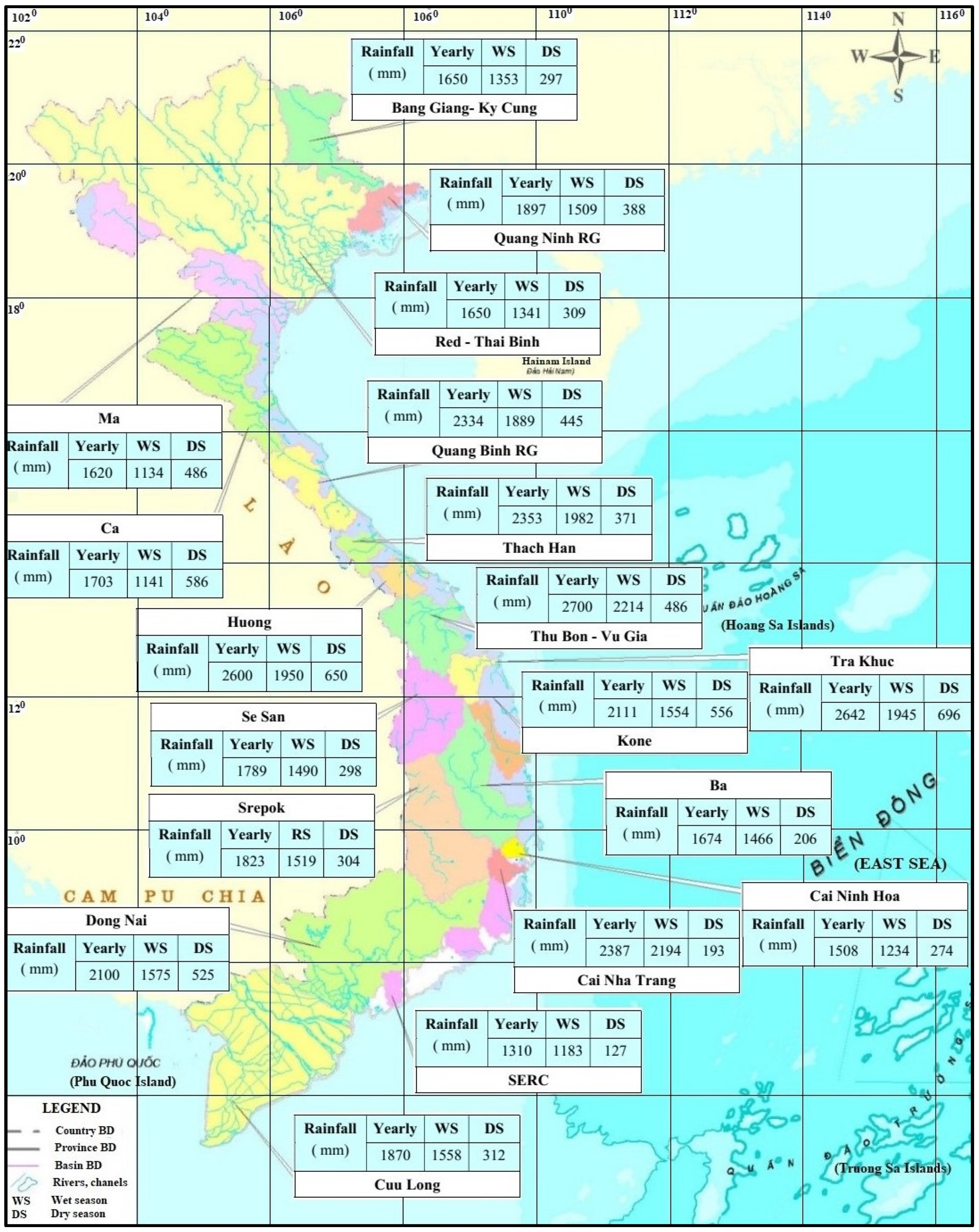
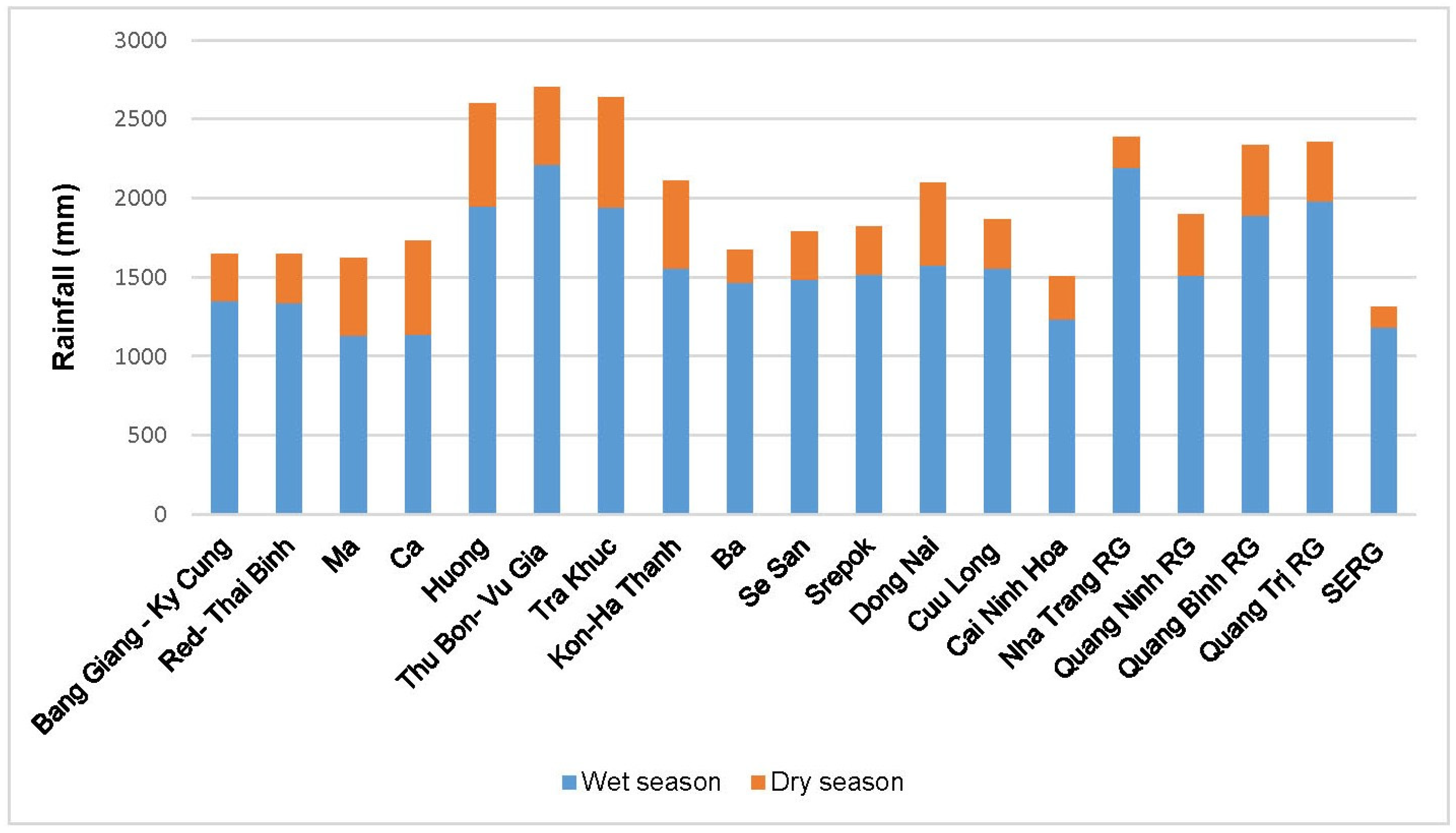
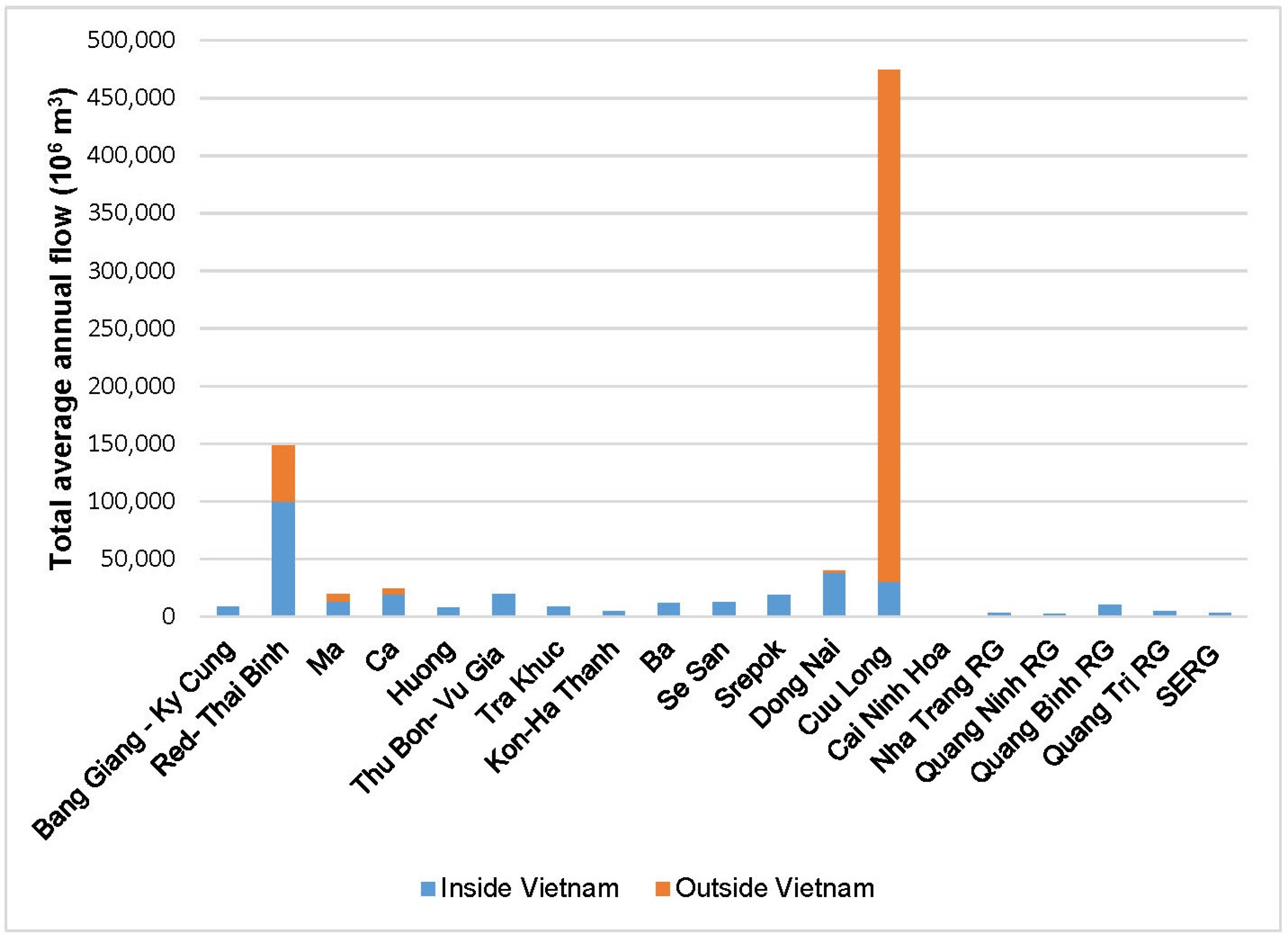
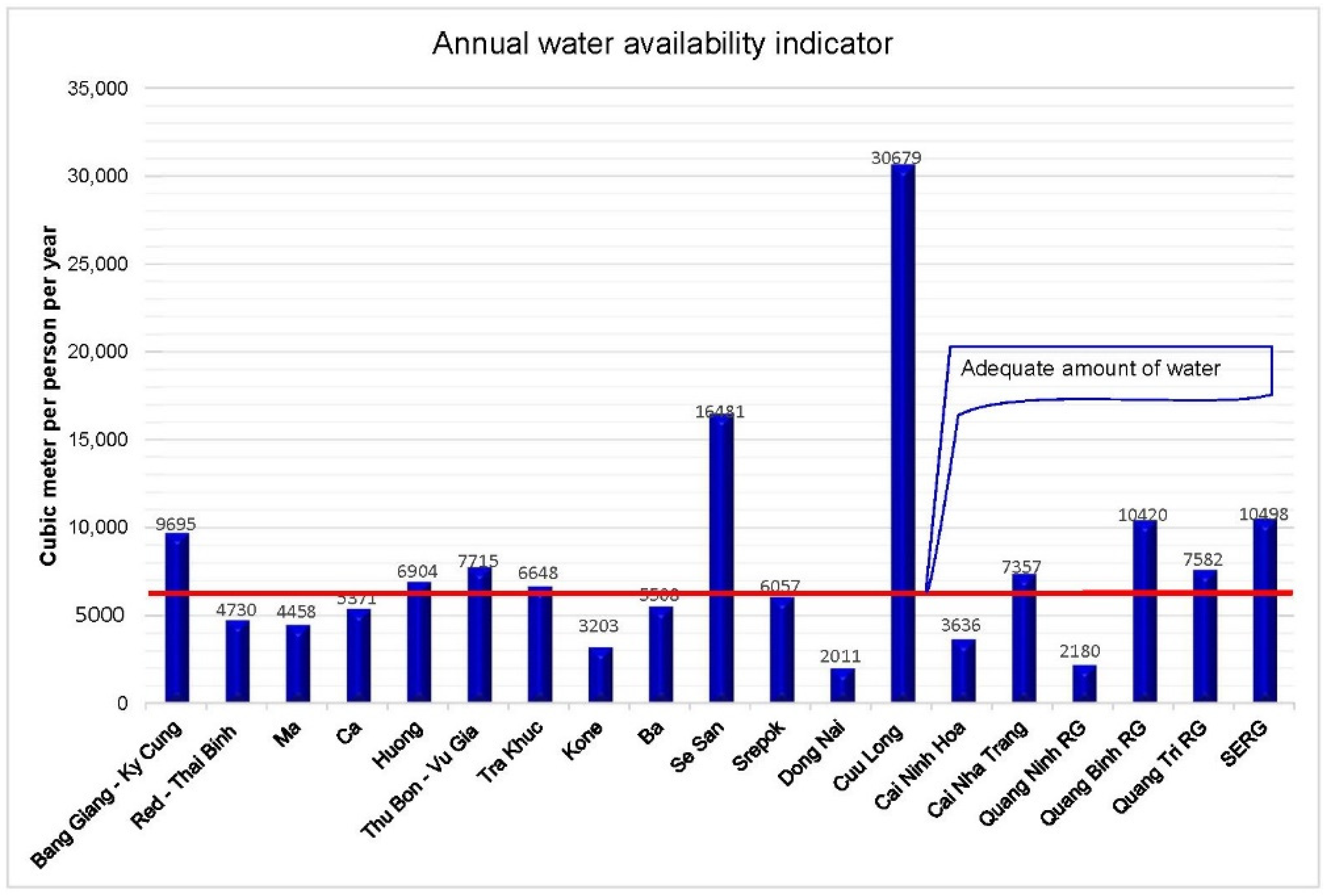
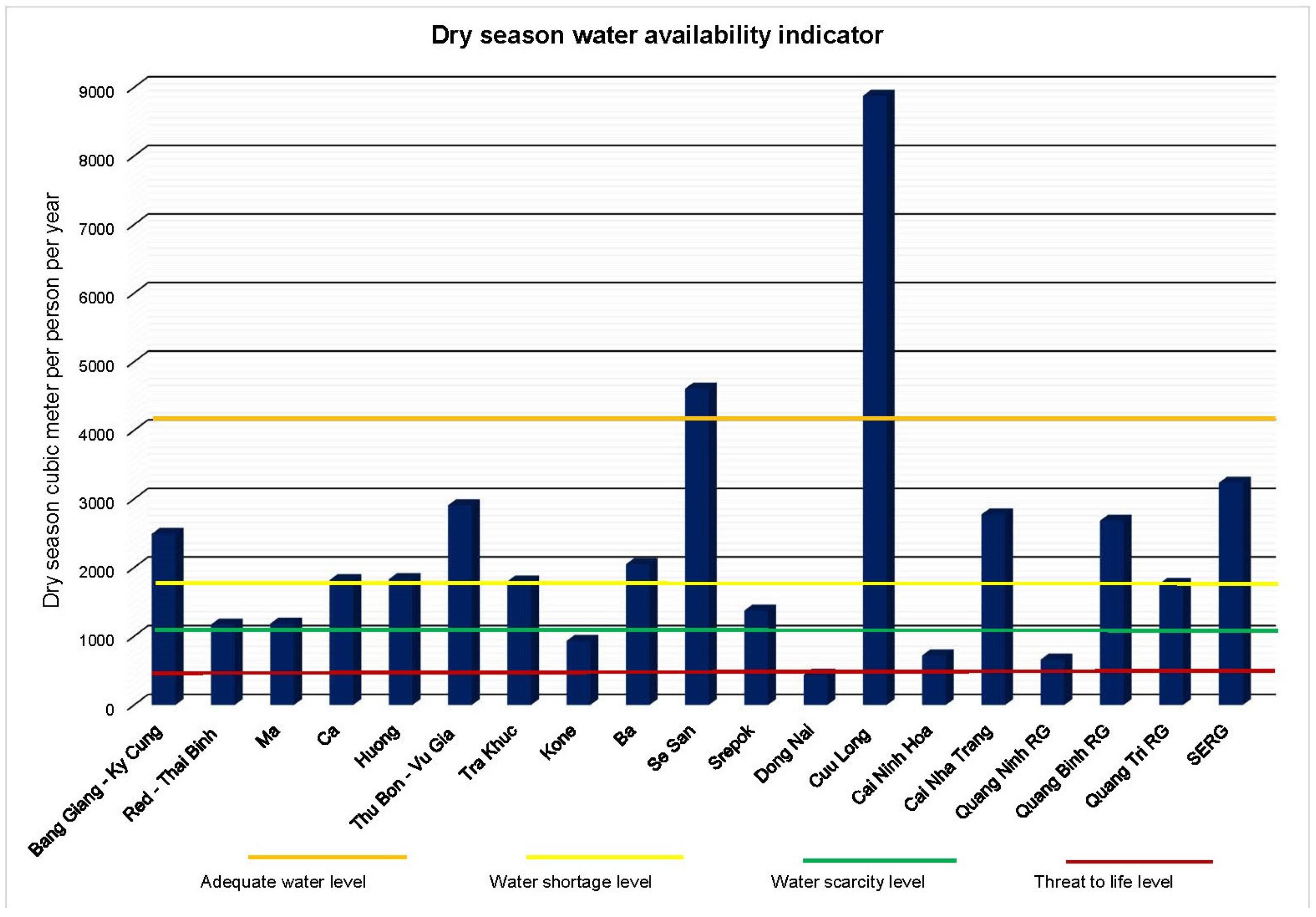
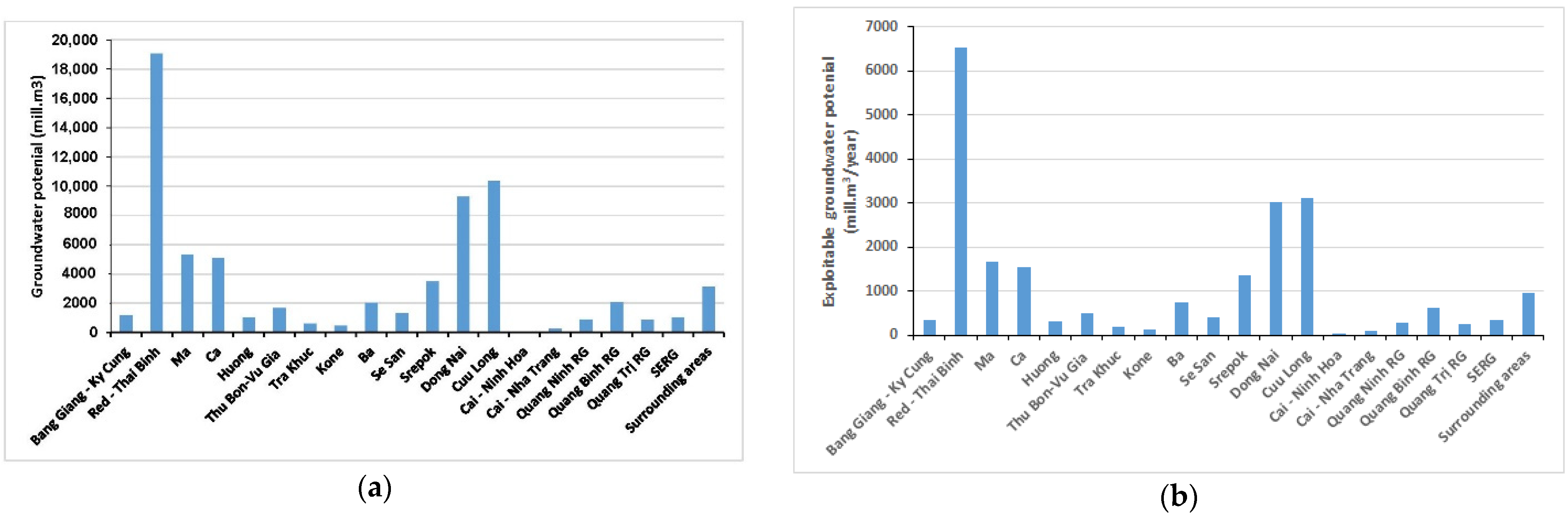
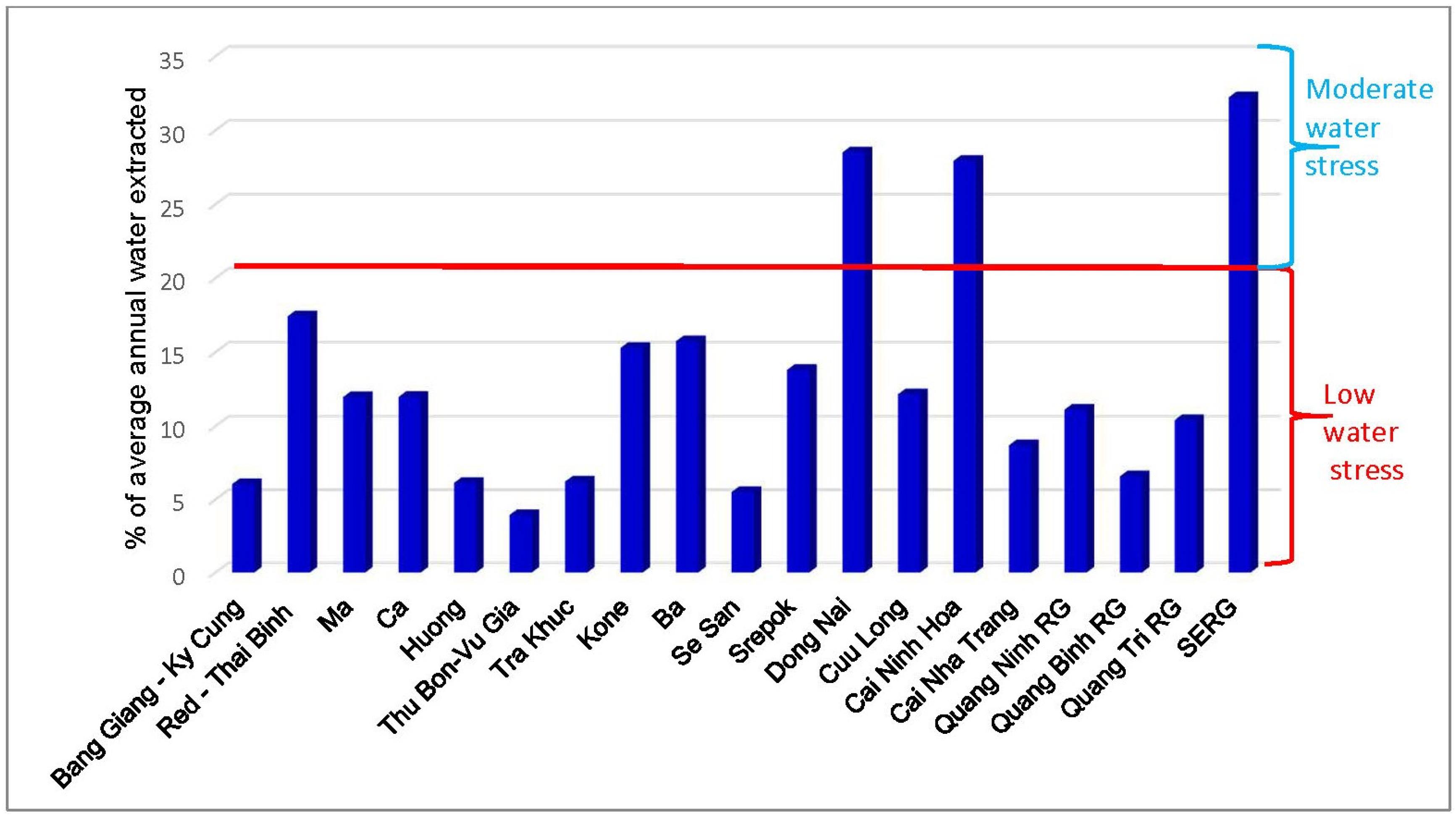
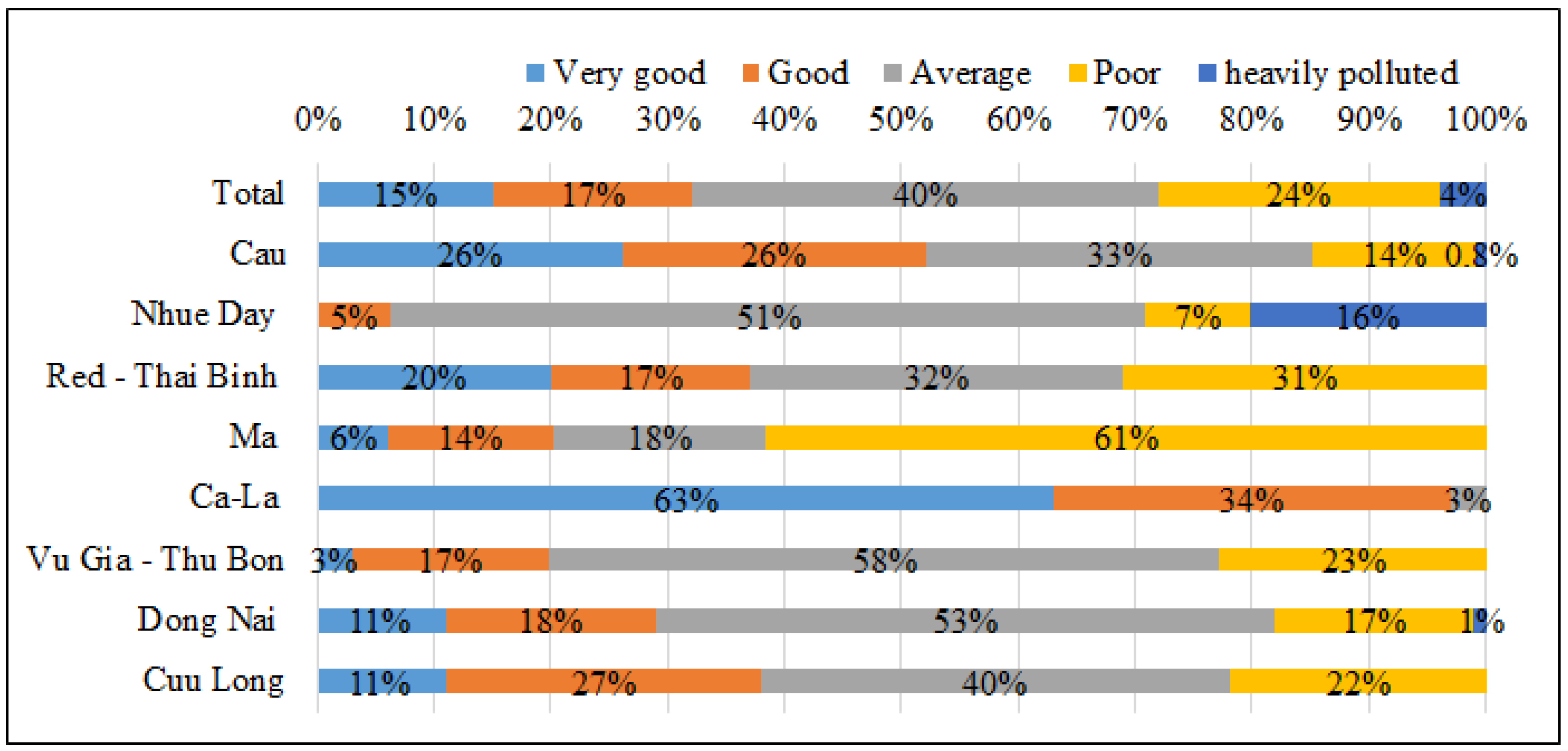
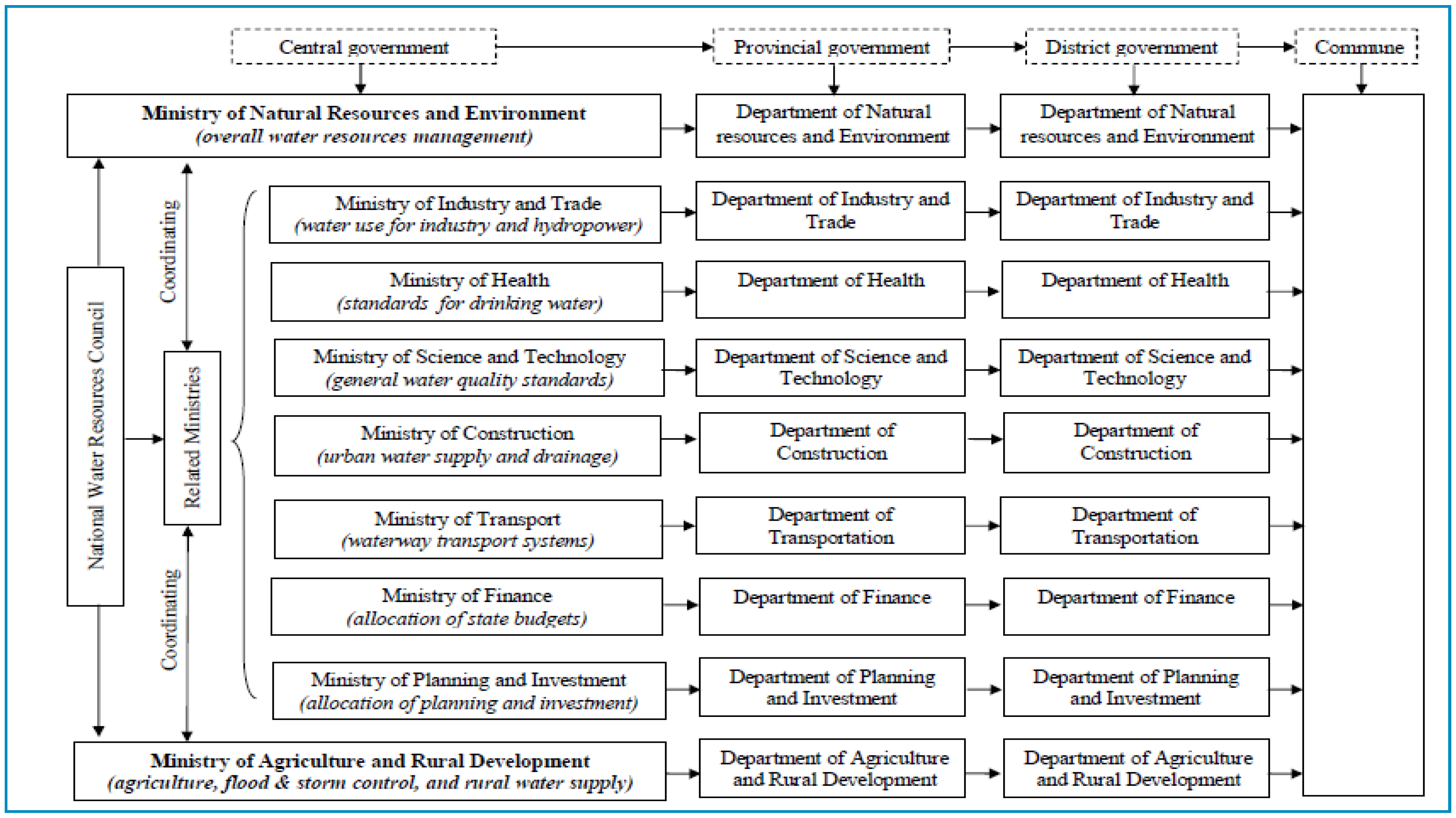
Table 1.
Water demand in river basins by the years 2022, 2025, 2030, and 2050.
| River Basin | Water Demand (Million m3) | Proportion of Basin Water Demand Compared to Total National Water Demand (%) | ||||||
|---|---|---|---|---|---|---|---|---|
| 2022 | 2025 | 2030 | 2050 | 2022 | 2025 | 2030 | 2050 | |
| Bang Giang–Ky Cung | 521 | 549 | 576 | 641 | 0.45 | 0.46 | 0.47 | 0.49 |
| Red–Thai Binh | 25,845 | 28,021 | 28,181 | 31,253 | 22.08 | 23.27 | 23.18 | 23.88 |
| Ma | 2360 | 2460 | 2547 | 2625 | 2.02 | 2.04 | 2.10 | 2.01 |
| Ca | 2857 | 2826 | 2825 | 2913 | 2.44 | 2.35 | 2.32 | 2.23 |
| Huong | 504 | 500 | 505 | 546 | 0.43 | 0.42 | 0.42 | 0.42 |
| Thu Bon–Vu Gia | 762 | 781 | 790 | 844 | 0.65 | 0.65 | 0.65 | 0.65 |
| Tra Khuc | 521 | 582 | 601 | 683 | 0.45 | 0.48 | 0.49 | 0.52 |
| Kone | 725 | 735 | 745 | 795 | 0.62 | 0.61 | 0.61 | 0.61 |
| Ba | 1896 | 1934 | 1954 | 2018 | 1.62 | 1.61 | 1.61 | 1.54 |
| Se San | 707 | 1.153 | 1153 | 1749 | 0.60 | 0.96 | 0.95 | 1.34 |
| Srepok | 2539 | 2752 | 2752 | 4055 | 2.17 | 2.29 | 2.26 | 3.10 |
| Dong Nai | 11,398 | 11,456 | 11,916 | 14,326 | 9.74 | 9.52 | 9.80 | 10.95 |
| Cuu Long (Vietnam Mekong) | 57,649 | 57,892 | 58,154 | 58,787 | 49.26 | 48.08 | 47.83 | 44.92 |
| Cai Ninh Hoa | 214 | 227 | 229 | 256 | 0.18 | 0.19 | 0.19 | 0.20 |
| Cai Nha Trang | 278 | 255 | 248 | 248 | 0.24 | 0.21 | 0.20 | 0.19 |
| River basin group in Quang Ninh (Quang Ninh RG) | 307 | 331 | 345 | 406 | 0.26 | 0.27 | 0.28 | 0.31 |
| River basin group in Quang Binh (Quang Binh RG) | 666 | 689 | 699 | 732 | 0.57 | 0.57 | 0.57 | 0.56 |
| River basin group in Quang Tri (Quang Tri RG) | 486 | 501 | 507 | 527 | 0.42 | 0.42 | 0.42 | 0.40 |
| River basin group in the southeast (SERG) | 1066 | 1121 | 1089 | 1159 | 0.91 | 0.93 | 0.90 | 0.89 |
| River basin group on the central coast (CCRG) | 5727 | 5632 | 5757 | 6320 | 4.89 | 4.68 | 4.74 | 4.83 |
| Total | 117,027 | 120,396 | 121,573 | 130,885 | 100 | 100 | 100 | 100 |
Data source: Synthetic Report on National Master Plan for Water Resources in the Period 2022–2030 with Vision to 2050 [13].
Table 2.
Current water availability and use in river basins.
| Basin | Water Availability (Bil m3/Year) | Water Use (Bil m3/Year) | ||||
|---|---|---|---|---|---|---|
| Yearly | Dry Season | Wet Season | Yearly | Dry Season | Wet Season | |
| Bang Giang–Ky Cung | 9.8 | 3.0 | 6.8 | 0.5 | 0.3 | 0.2 |
| Red–Thai Binh | 170.4 | 49.7 | 120.8 | 20.5 | 11.9 | 8.6 |
| Ma | 25.3 | 8.5 | 16.8 | 2.4 | 1.5 | 0.8 |
| Ca | 29.4 | 11.3 | 18.1 | 1.9 | 1.4 | 0.5 |
| Huong | 9.4 | 3.0 | 6.4 | 0.5 | 0.4 | 0.1 |
| Vu Gia–Thu Bon | 21.1 | 8.6 | 12.5 | 0.7 | 0.7 | 0.1 |
| Tra Khuc | 9.0 | 2.7 | 6.3 | 1.1 | 0.9 | 0.2 |
| Kôn–Hà Thanh | 5.2 | 1.7 | 3.5 | 0.7 | 0.5 | 0.2 |
| Ba | 14.1 | 5.8 | 8.2 | 1.9 | 1.6 | 0.3 |
| Sa San | 14.2 | 4.4 | 9.8 | 0.7 | 0.5 | 0.2 |
| Srepok | 21.9 | 6.2 | 15.7 | 2.5 | 2.0 | 0.6 |
| Dong Nai | 51.7 | 15.6 | 36.1 | 12.1 | 8.7 | 3.3 |
| Cuu Long (Vietnam Mekong) | 500.0 | 152.4 | 347.7 | 55.3 | 35.5 | 19.7 |
| Other coastal river basins | 54.4 | 19.5 | 34.9 | 8.2 | 6.7 | 1.5 |
| Total | 935.9 | 292.4 | 643.5 | 108.9 | 72.7 | 36.2 |
Data source: Synthetic Report on National Master Plan for Water Resources in the Period 2022–2030 with Vision to 2050 [13].
Disclaimer/Publisher’s Note: The statements, opinions and data contained in all publications are solely those of the individual author(s) and contributor(s) and not of MDPI and/or the editor(s). MDPI and/or the editor(s) disclaim responsibility for any injury to people or property resulting from any ideas, methods, instructions or products referred to in the content. |
© 2023 by the authors. Licensee MDPI, Basel, Switzerland. This article is an open access article distributed under the terms and conditions of the Creative Commons Attribution (CC BY) license (https://creativecommons.org/licenses/by/4.0/).
Share and Cite
MDPI and ACS Style
Pham, Q.-N.; Nguyen, N.-H.; Ta, T.-T.; Tran, T.-L. Vietnam’s Water Resources: Current Status, Challenges, and Security Perspective. Sustainability 2023, 15, 6441. https://doi.org/10.3390/su15086441
AMA Style
Pham Q-N, Nguyen N-H, Ta T-T, Tran T-L. Vietnam’s Water Resources: Current Status, Challenges, and Security Perspective. Sustainability. 2023; 15(8):6441. https://doi.org/10.3390/su15086441
Chicago/Turabian StylePham, Quy-Nhan, Ngoc-Ha Nguyen, Thi-Thoang Ta, and Thanh-Le Tran. 2023. "Vietnam’s Water Resources: Current Status, Challenges, and Security Perspective" Sustainability 15, no. 8: 6441. https://doi.org/10.3390/su15086441
Note that from the first issue of 2016, this journal uses article numbers instead of page numbers. See further details here.