1. Introduction
Around the world, populations and cities are growing rapidly. It has been estimated that by the year 2050, 7 out of 10 people will live in cities [
1]. All these people need food, which is traditionally grown in rural areas [
2]. Where food was historically grown close to urban centres, cities are now expanding across the fertile lands originally used for agriculture [
3,
4]. According to recent studies, the current trend of urban expansion requires approximately 1.2 million km
2 of additional land globally by the year 2030, making land an increasingly scarce resource [
1,
5].
Nowadays, food comes not only from the immediate vicinity of the city but from all over the world. It takes chains of actors (e.g., farmers, traders, wholesalers, and retailers) and activities to get food from farm to fork [
6]. These activities involve production, processing, transport, consumption, and waste disposal—a web of activities that we collectively call the food system [
7,
8,
9,
10]. Besides being driven by environmental factors such as land, water, and climate, the food system is largely driven by autonomous market development and is thus opportunistic. It seizes opportunities that are favourable to an actor at that time. As a consequence, developments can occur that are unfavourable to society at large. Examples include deforestation of the tropical rainforest in favour of palm oil production or soy production for cattle feed. Other unfavourable developments are overfishing, an increase in packaging materials, and closer to the city, the occurrence of lacking refrigeration opportunities at fresh markets, resulting in health risks, food loss, and (extra) waste.
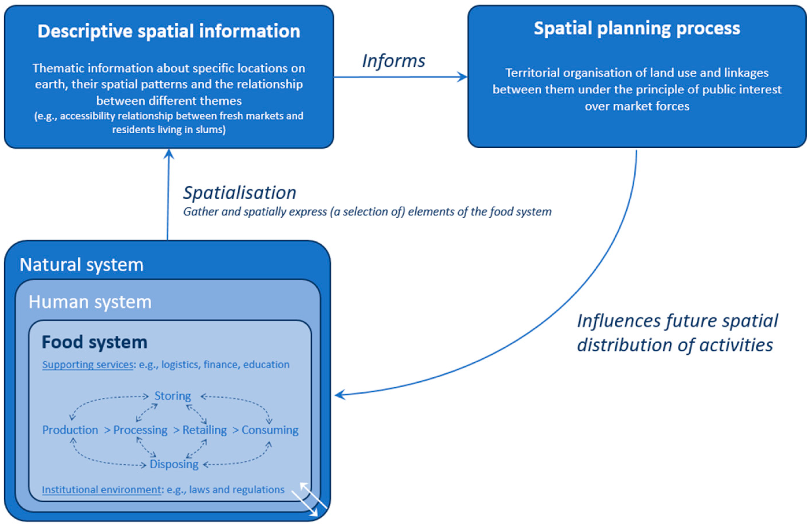
Government policies are required in cases in which food system activities need to be regulated to improve food system outcomes and resilience, and limit negative trade-offs, especially when private or civil initiatives (alone) cannot address such requirements. Spatial planning is a public sector function to influence the future spatial distribution of activities. The aim is to create a more rational territorial organisation of land use and the linkages between them to balance demands for development with the need to protect the environment, and to achieve social and economic objectives [
11]. With regard to the food system, spatial planning can then include designating areas where fishing is allowed up to a certain maximum volume, designating locations for fresh markets with facilities that meet hygienic standards (refrigeration, water, etcetra) to guarantee safe food, designating locations for waste disposal, good supply infrastructure, and parking facilities near markets, and urban gardening for fresh food from the neighbourhood, which is less subject to market-driven price fluctuations and uncertainties in distant import chains (e.g., crop failures and geopolitical instability).
Spatial planning generally does not focus on the food system [
12] but rather on identifying development zones for residential, transport, industrial, and recreational functions. Around Lisbon (Portugal), however, the food system has been incorporated into local spatial planning by integrating peri-urban and urban agriculture. Herewith, the supply chain is shortened to reduce the negative impacts associated with longer chains [
13]. Additionally, spatial planning for food systems can be targeted to include societal variation. In South Africa, for example, marginalised communities are at risk of being excluded if there is only food supply via relatively expensive malls and supermarkets. Therefore, fresh markets that offer affordable products are planned at specific locations close to the marginalised communities [
14]. In the Dutch city of Ede, areas have been designated where farmers sell their own produce. In other locations in Ede, community gardens are established where people in a neighbourhood grow food together. Schoolchildren are also introduced to growing their own food in kitchen gardens from an early age [
15].
In developing cities around the world, spatial planning for food systems proves more challenging. The Dhaka Metropolitan Area (DMA) [
16,
17] in Bangladesh, for example, is one of the fastest-growing metropoles in the world. With a population of over 22 million residents, DMA is one of the most densely populated areas on the planet with a density of 23,234 people per km
2 within its geographic area of 300 km
2 [
18]. As part of the Sustainable Development Goal (SDG) 2, which is to end hunger, access to nutritious and healthy food is a significant challenge for the sky-rocketing urban population and especially for the urban poor in the DMA. To include the food system in spatial planning, the food system must first be mapped to understand how the local food system functions—this process is known as spatialisation [
2]. By doing so, it informs the spatial planning process, which in turn influences the future spatial distribution of activities (see
Figure 1).
Several studies have been conducted on spatialisation in food systems. Nevertheless, these are limited to developed city regions [
13,
14], and little is known about developing city regions. This paper explores the spatial dimension and the potential role of spatialisation and spatial planning in the understanding and improvement of the food system of the fast-growing Dhaka Metropolitan Area as an example of a developing city region.
2. Materials and Methods
To explore the spatial dimensions of the DMA food system, two studies were conducted: (1) urban food footprint analysis and (2) the development of an interactive map portal of the DMA food system and specific narratives. These are two different ways of bringing the urban food system into a spatial perspective and with different means. Nonetheless, the spatialisation activities both show the value of bringing the food system into the actual spatial context. The urban food footprint takes the angle from the national perspective, while the spatial maps are written and illustrated from the DMA viewpoint.
To gain insights into the current uptake and potential role of spatial data and spatial planning, semi-structured interviews were carried out. Together, the two research studies showcase possible tools for gathering insights, but most of all highlight the importance of bridging the gap between food system policies and research, spatialisation, and spatial planning.
2.1. Urban Food Footprint Analysis
The first study compares the consumption pattern of Dhaka’s citizens with the agricultural production capacity of Bangladesh. It calculates and projects the urban food footprint in agricultural area demand (in hectares) to fulfil the consumption needs of the DMA. For this, the Urban Food Footprint tool was used [
20]. For the calculations, two assumptions were made:
All the food production takes place in Bangladesh itself, excluding food imports.
The consumption pattern of Dhaka’s citizens is equal to that of the average Bangladeshi, excluding differences in diets due to food availability and money spending capabilities in the DMA.
The Urban Food Footprint tool required the following input data: (1) population size of the DMA in 2021; (2) consumption pattern (meat, eggs, milk, fish, rice, pulses, vegetables, roots, maize, wheat, and bread); (3) food production quantities for animal products (kg/animal/year) and plant produce (kg/hectare/year); (4) food production efficiency (in %) to account for losses in the food value chain; (5) animal fodder production (kg/hectare/year) extracted from total production capacity of a product; and (6) animal fodder consumption (kg/animal/year). The input data were derived from [
21,
22,
23,
24,
25]. Based on the input data, the Urban Food Footprint tool calculated for every food product the city’s total food consumption in kg and the food production capacity in kg per hectare. The double and triple crop rotation practices applied in Bangladesh were hereby taken into account, whereby two or three rounds of harvest can be taken from the same field within one calendar year. Through division of the consumption by the production, the amount of agricultural area demand per food product was calculated. The agricultural area demand for every product is then summarized to determine the total hectares of area demand. As a last step, the total agricultural demand was visualized on a map of Bangladesh with a circle reflecting the size of the demand.
2.2. Development of an Interactive Map Portal and Specific Narratives on Food Systems
To explain and illustrate to municipal stakeholders the potential of spatial data and maps about the DMA food system, an interactive map portal, including seven narratives on food systems, was developed and published online [
26]. Each narrative combines a spatial map of a specific food system aspect with a compelling story that inspires action. Central to every narrative is a food system question addressing a broad range of societal themes. For instance, how much space is available to utilise for rooftop gardening? Or, what is the level of accessibility of fresh markets for the urban poor? After defining central food system questions, the available existing (spatial) data necessary to answer the questions were collected from different sources (i.e., Bangladesh Agricultural Research Council, Bangladesh Space Research and Remote Sensing Organisation, and World Bank). If additional data were required for the mapping, these data were collected. For example, additional data were required on the available services at wet markets (i.e., availability of electricity, clean water, and toilets) and these data were collected at all the wet markets in DMA through a survey (see
Supplementary Materials S1). The data collection was followed by spatial analysis of the data using QGIS and visualization resulting in a spatial map. To answer the food system question of the narrative, a story explaining the background of the map and the results was written. These stories had the following structure: introduction with scene setting, results of the mapping in numbers, and consequences or recommendations. The stories were supported by key facts. To develop the story, desk research was performed to imbed the topic into societal themes. The stories were shared and discussed with experts for validation. Next to the narratives, numerous maps of different food system elements were gathered and brought together in an interactive portal. This portal is freely available online [
26].
2.3. Conducting Semi-Structured Interviews for the Role of Spatialisation and Spatial Planning in DMA’s Food System
The actual uptake of spatial information on food systems depends on the actual stakeholders. A semi-structured interview approach was conducted to explore the current role of spatialisation and spatial planning in the DMA’s food system, as this approach provided an opportunity to explore the thoughts of the participants. The participants were selected based on the snowball method as a non-random sampling technique using the networks of the authors [
27]. In total, 17 participants were interviewed of whom 6 were public stakeholders from the government of Bangladesh (2 national and 4 local governmental stakeholders), and 11 participants were international experts with experience in food systems planning in the DMA. The interviews were all conducted online using Microsoft Teams video calls and took between 45 and 60 min per participant. Verbal permission was obtained from the participants to record the interviews for transcription purposes. The questions asked in the interviews focused on the case of the DMA and covered the following themes: (a) the food system, (b) spatialisation, (c) spatial planning, and (d) governance. The interview questions were informed by literature and were tailored to the participants based on the participants’ backgrounds and expertise and insights gained from previous interviews. An extensive list of the specific interview questions can be found in the
Supplementary Materials S2. After the interviews, the responses were transcribed and processed anonymously taking a semantic approach [
28]. The explicit content of the interviews was used to develop an overview of the DMA food system and the role of spatialisation and spatial planning therein. In addition to the interviews, reports and news articles were consulted as background material to complete the overview.
3. Results
3.1. Urban Food Footprint
The DMA 2021 population of 21,741,090 citizens [
1] has an average consumption pattern as shown in
Table 1. The product group described as vegetables, spices, and others also includes fruits and sugar cane.
To fulfil this consumption pattern for the whole DMA population, the Urban Food Footprint tool calculated that 1.9 million hectares of agricultural land is required, which is 0.09 hectares of agricultural land per DMA capita. The agricultural land demand is split up into 82% of the demand needed for plant production directly for human consumption and 18% is used to produce indirect animal products for human consumption. The largest demand for the DMA citizen’s food production is for rice production with 1.45 million hectares, which equals 76% of the total agricultural area demand.
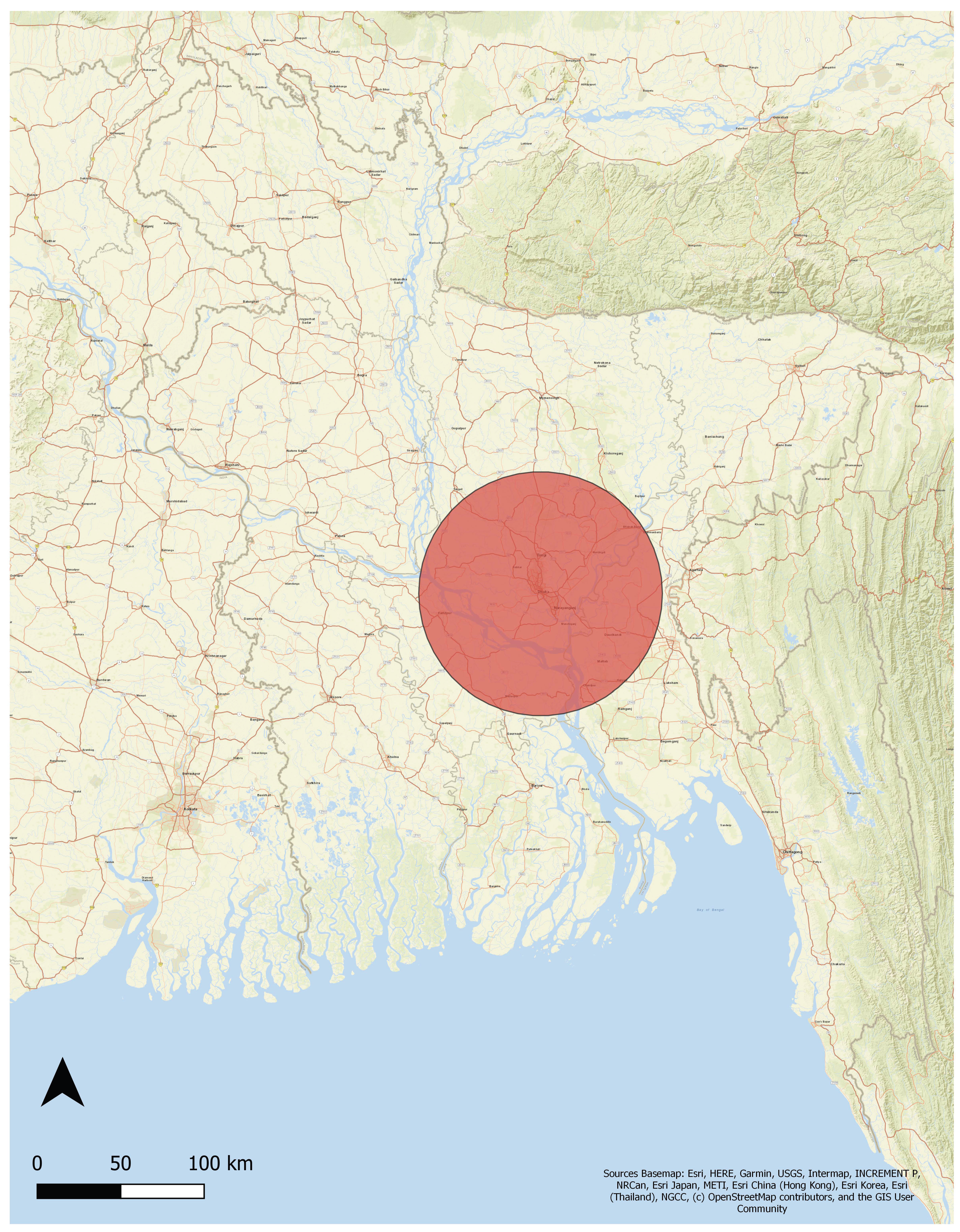
Figure 2 illustrates the area demand to feed the DMA’s citizens in perspective to the size of Bangladesh. The circle covers 12.8% of the total land area of Bangladesh. As the available agricultural area in Bangladesh is 8.06 million hectares [
30], the agricultural demand from the DMA population would occupy 18% of the available agricultural land, thereby leaving 82% of the agricultural area to feed the other 144.6 million people living in Bangladesh.
3.2. An Interactive Map (GIS) Portal and Specific Narratives
In total, six narratives on food systems were developed and published online (see also
Supplementary Materials S3) [
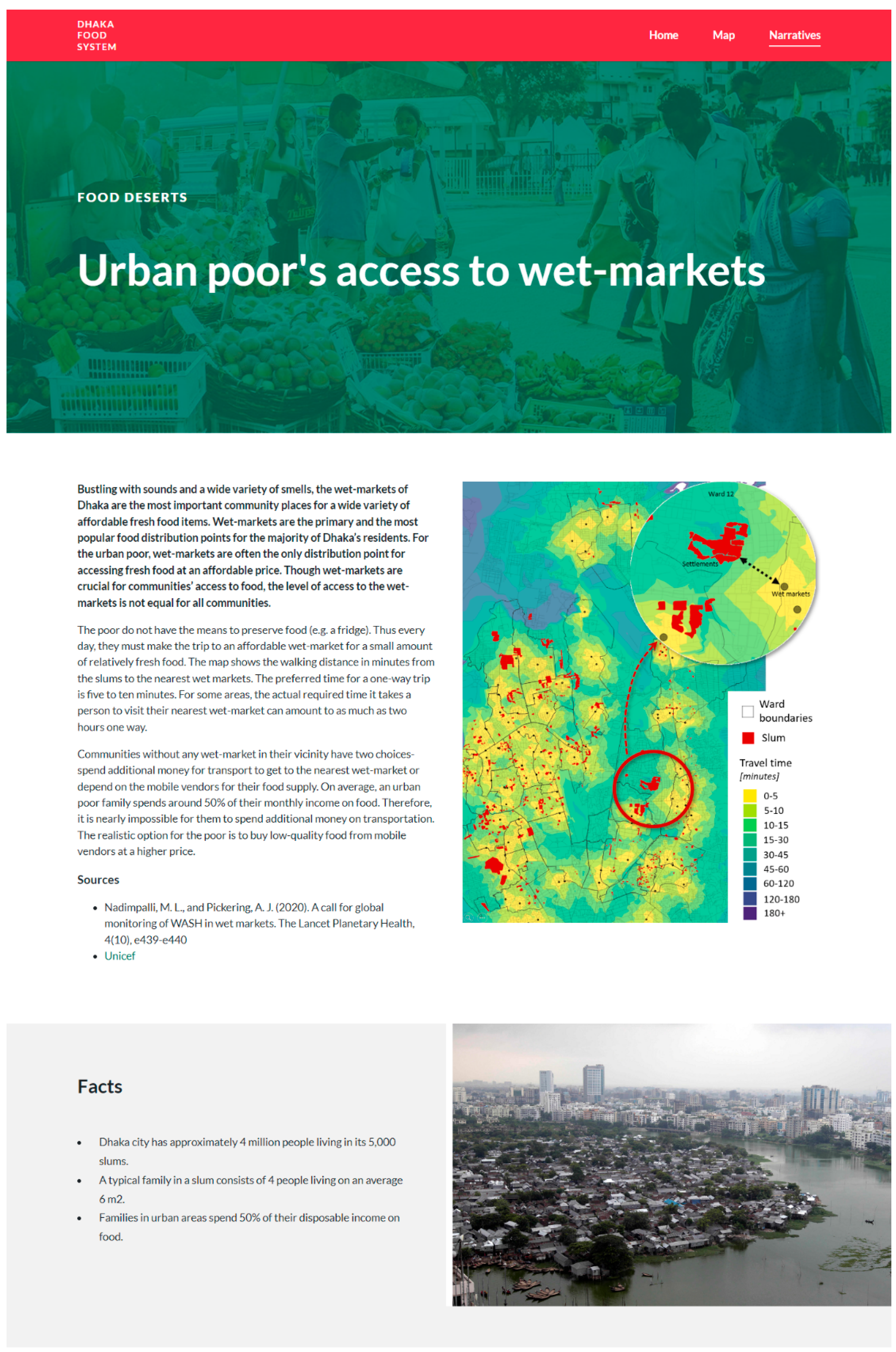
26]. The narrative on the urban poor’s access to fresh markets is published below. The map shows the travel time between fresh markets and the slum areas in the Dhaka North City Corporation (DNCC) (see
Figure 3). The narrative application lies in showing where the service areas of fresh markets are compared with the location of slum areas. Though access to markets is not only dependent on distance but also on purchasing power, it will enhance market access if fresh markets are reasonably close to the slum areas. Therefore, the map on the narrative indicates where new fresh markets can potentially be established to increase accessibility for the urban poor.
3.3. Semi-Structured Interviews for the Role of Spatialisation and Spatial Planning in DMA’s Food System
The semi-structured interviews first of all provided insights into the current spatial elements of the DMA’s food system. Regarding the elements of the food system, interviewees did not identify spatial aspects of food consumption. With regard to food production, Bangladesh has a total of 8.06 million hectares of land available for cultivation [
30]. Almost 80% of vegetables and fruits consumed in the DMA are cultivated on the farmlands of the country and are transported to the cities for wholesale and retail. Only 4–5% of the land of the DMA is under cultivation; therefore, the majority of the urban population relies on the food produced outside the metropolitan region. To contribute to food production in urban areas, city corporations are promoting urban gardening and roof-top gardening. It has been estimated that DMA has around 450,000 roofs covering 4500 ha of land, readily available for roof-top gardening [
31]. However, current practices in food production on roofs are mostly for recreational purposes and social cohesion [
32]. There is neither a centralised policy to promote roof-top gardening nor a monitoring committee to evaluate the contribution of roof-top gardening to the Dhaka food system.
Food processing occurs at different stages in the value chain and therefore also at different locations. For example, in the processing areas outside the DMA, onions are dried and packaged for retail at supermarkets and fresh markets in the DMA [
33]. At the fresh markets, food processing is performed by, for instance, slaughtering cattle, cutting onions and mangos, and pressing mangos to make juice [
34,
35,
36]. All of these practices are currently performed on a small scale; however, an interviewee said that big corporations are developing an interest in the food processing industry, leading to more structure in the process. Another interviewee suggested that for the meat value chain, the location of new slaughterhouses and fresh markets should be determined based on road accessibility and the points where live animals are coming into the DMA.
The DMA has approximately 386 fresh markets serving about 85% of its residents; thus, fresh markets play a key role in the food distribution and retail of the DMA. The DNCC and Dhaka South City Corporation (DSCC)—with 121 and 97 fresh markets, respectively—are the largest and most population-dense city corporations. Interviewees mentioned that most fresh markets were constructed 20+ years ago without any spatial recognition of transportation, traffic, and capacity to meet the current food demands per district of the city corporation. With time, most residential infrastructure expanded without any spatial planning and multiple interviewees highlighted that the challenges for urban food supply-chain worsened over time. For example, for the onion supply chain, there are only five wholesale locations for the entire DMA region. These wholesale markets are one of the biggest commodity hubs and are the entry points for food distribution for the entire DMA region. In addition, poor transportation infrastructure (roads, highways, bridges, and bypasses) creates traffic jams at multiple locations. The river Padma is another significant logistic bottleneck for the food supply chain. There are fewer ferry services available for commercial use; therefore, the only bridge on the river—the Bangabandhu bridge—faces severe traffic jams and uncertain waiting times. (Note that this study took place before the completion and opening of the Padma Bridge in 2022). If truck drivers are unable or unwilling to make payments, the ferry crossing adds an additional time of 5–25 h to cross the river. One of the interviewees highlighted that this has severe implications in terms of degraded food quality leading to post-harvest food losses and food waste at the fresh markets.
Food waste was recognized as another concern by most interviewees. The DMA produces approximately 8000 metric tons of waste every day, out of which 60–70% is organic food waste [
37]. Food loss at the fresh markets as a result of degraded food quality poses a severe challenge. A majority of the interviewees indicated that the food loss is a result of limited transport infrastructure and a lack of storage and cooling facilities. Additionally, most fresh markets lack basic facilities of fresh water supply, drainage, ventilation, and electricity supply. There are waste transfer stations for the fresh markets of DNCC and most waste goes to landfill sites. There are pilot projects on ‘black soldier fly initiatives’ for composting; however, interviewees recognized that to combat the waste challenge there is the opportunity to use bio-digester plants in the DMA. However, there is a lack of space and city corporations struggle to spatially recognize waste as an element of the food system.
Moreover, the semi-structured interviews revealed insights into how descriptive spatial information currently informs the spatial planning process, both at the national and the DMA levels. At the national level, there are various ministries and departments working on the food system and land use planning. However, interviewees indicated that there is no central governing organisation (yet) that is dedicated to spatial planning at the country level. Moreover, the food system is still an “alien” terminology for most interviewed urban planners. It was mostly expressed that the absence of an institutional framework for the urban food system further hampers the integration of urban food elements (e.g., production). Communication gaps and a lack of fiscal budget are said to be the main cause of poor policy infrastructure supporting the current food system. The spatial distribution of activities in the food system is in various ways influenced by spatial planning. According to interviewees, at the national level, there are three prime government divisions that play a key role in the policy framework of the food system:
The Food Monitoring and Evaluation Unit from the Ministry of Food is the primary division that coordinates with 18 ministries and is directly responsible for the food system of Bangladesh. The Ministry of Food is currently preparing land-use maps; however, according to one of the interviewees they are neither collaborating with any spatial planning institutes nor sharing them with other ministries and departments.
The Ministry of Land is responsible for land-use zoning, land registration, and land dispute cases. However, multiple interviewees recognized that there is a limited budget and limited human resources available per fiscal year at the ministry thus creating various complexities for the ministry’s mandates.
The Local Government Engineering Department (LGED) is responsible for building transportation infrastructure such as roads, bypasses, highways etcetera. The LGED has various land-use maps for all municipalities at the national level that are used for planning purposes. However, one of the interviewees mentioned that most maps were made 20–30+ years ago and are outdated while residential infrastructure has expanded enormously.
At the DMA level, additional governance for spatial planning of the food system is applied and this is not always connected with the national level. Rajdhani Unnayan Kartripakkha (RajUK), as the development authority of the government of Bangladesh at the DMA level, is responsible for coordinating urban development at various ministerial levels. RajUK prepared a Detailed Area Plan (DAP) for 2022–2035 for the land zoning of the DMA. The urban planners from the four city corporations in the DMA utilize the DAP to approve or deny land-use registration per land zone. Urban planners do not coordinate with the above-mentioned ministries. There is no policy framework for the integration of the food system at the DMA level. For example, one of the interviewees highlighted that there is no spatial planning information available in the DAP related to urban agriculture of the DMA as 4–5% of agricultural land is governed by the Ministries of Food and Agriculture. There is also not a fully operational institutional framework both at the national and the DMA levels for managing the food system (yet) as the concept of a food system is only recently being used. Additionally, the spatial distribution of activities is also influenced at a decentralised level. As a first step, in collaboration with NGOs and the UN FAO, city corporations have created city food charters to raise awareness of food security, food safety, and food hygiene. These endorsed food charters are designed to ultimately guide municipal policies and decision-making in local food systems targeting the urban poor and facilities available at the fresh markets [
38].
4. Discussion and Conclusions
In this paper, the potential role of spatialisation and spatial planning in food systems was studied through the case study of the fast-growing city of Dhaka, Bangladesh. Studying the DMA and its food system through three different methodological approaches resulted in an understanding of the current state of spatialisation and spatial planning integration within the DMA food system. The spatialisation of the Urban Food Footprint analysis suggests that the DMA citizens can be sufficiently fed through domestic agricultural production in Bangladesh even when the population continues to increase. Nevertheless, this needs extensive further research to include all relevant sources of food in the food basket as well as the effect of food import and export. A growing population will continue the urbanization of the metropole and increase the agricultural area demand, putting pressure on the land surrounding the capital [
39,
40]. Considering this surrounding land has various uses, including for agricultural production of the capital—which will be pushed outwards as the city expands—agricultural production for the rest of the Bangladeshi population is challenged as land availability declines.
Besides the spatialisation of the Urban Food Footprint, the development of an interactive map (GIS) portal and specific narratives support the learning process of understanding and solving issues related to the food system, using a spatial perspective. Both the food footprint spatialisation and the spatial maps showed the potential for the use of spatialisation and spatial information in helping to understand the DMA food system. As it is expected that the food system will substantially change towards the future, such spatial insight into the food system, both at the DMA and country levels, is crucial in light of economic development and land use, as well as climate change.
The interview results showed that the implementing actors are still lacking awareness of the food system and spatial information in general, in addition to specific knowledge of spatial planning in the DMA’s food system. Furthermore, external stakeholders within the DMA—national level actors, policy departments, and RajUK—are currently unaware of the food system and spatial aspects that are present in the DMA food system and therefore do not take the food system into consideration while developing spatial plans. Not only is awareness about the concepts of this study (see
Figure 1) lacking, a more general lack of spatial planning governance both on the level of the DMA and on the national level was observed. The currently available planning instruments for Bangladesh and the DMA are limited to land-use zoning and there is an absence of integration of the food system therein. There is no policy framework available yet to implement tools and instruments for spatial planning. A cause of the above findings might be found in the perceived limited freedom for communication across ministerial boundaries. This may prevent actors from developing planning instruments related to the food system at least on a national level. At the same time, at the decentralised level, internal stakeholders—city cooperation stakeholders who were informed in food charters—are aware of spatialisation and the role of maps in food systems. However, their awareness has not yet resulted in spatial planning for food systems. This is possibly related to their reliance on the (unaware) implementing actors. To establish the spatial planning practice for food systems, a more central role for spatial planning in governance is required.
During the interview process, an interview with a stakeholder from RajUK could not be conducted due to time constraints and the inability to establish contact. Therefore, information on the spatial planning process for the DMA and the presence or absence of a connection to food systems therein could only be studied through interviews with other actors and public reports. Additionally, little to no spatial information on food consumption was obtained as many initiatives are still in an early implementation phase in which spatially explicit thinking is not yet included in the initiatives. Moreover, a lack of freely available spatially explicit information hindered the complete understanding of the spatial elements in food processing of various food value chains. In addition, maps of, for instance, household availability and access to water, gas, and electricity in the DMA were not available, thereby limiting the background information for the narrative development. Stakeholders were reluctant to share their partially commercial—thus valuable—data.
It may further be noted that spatial information on infrastructure essential to food systems, e.g., road system and water-related infrastructure both at national and DMA levels, can further be explored and used in food system governance. In general, DMA-specific data are often not available. In these cases, we used the Bangladesh data as a proxy, e.g., per capita food consumption.
Both Van Berkum and Woodhill [
9,
19] discussed a systematic approach of food systems, acknowledging the interconnectivity between different food systems activities, resulting in a more robust system. Kasper [
2] adds the perspective of spatialisation as a way to “.. .. identify drivers and key points that allow [..] to adapt or transform (parts of) the urban food system in the long term toward improved working urban food systems that are more integrated, interactive, and resilient (p. 16).” These views were applied to the real-world example of the DMA food system in this study. Consequently, the potential and the bottlenecks of the DMA food system were identified.
All in all, Bangladesh is in a transformative process, coming from being a low income country and in the last years having established itself as a lower middle income country, on the way to being a upper middle income country by 2031 [
41]. In this transformative process, the DMA is easily positioned in the spotlight at a global level due to its skyrocketing population. Due to the rapid urbanization, the DMA food system is under enormous pressure to sustain the livelihood of urban dwellers. The methods used in this article are also relevant and applicable to similar cities and city regions around the world. The explorative study described in this article, based on the Urban Food Footprint analysis, food system mapping, and interviews, shows clearly that spatial planning informed by descriptive spatial information can play an important role in guiding the transformation to a more robust, resilient, and inclusive food system.

 ,
, 


