Article

An Expert Approach to an Assessment of the Needs of Land Consolidation within the Scope of Improving Water Resource Management

1
Department of Agricultural Land Surveying, Cadastre and Photogrammetry, University of Agriculture in Krakow, Mickiewicza 21 Street, 31-120 Krakow, Poland
2
Department of Sanitary Engineering and Water Management, University of Agriculture in Krakow, Mickiewicza 21 Street, 31-120 Krakow, Poland
3
Department of Hydraulics Engineering and Geotechnics, University of Agriculture in Krakow, Mickiewicza 21 Street, 31-120 Krakow, Poland
4
Lower Silesian Office of Geodesy and Agricultural Land in Wroclaw, Piłsudskiego 15/17 Street, 50-044 Wroclaw, Poland
5
Department of Ecology, Climatology and Air Protection, University of Agriculture in Krakow, Mickiewicza 21 Street, 31-120 Krakow, Poland
6
Department of Land Reclamation and Environmental Development, University of Agriculture in Krakow, Mickiewicza 21 Street, 31-120 Krakow, Poland
*
Author to whom correspondence should be addressed.
Sustainability 2022, 14(24), 16651; https://doi.org/10.3390/su142416651
Submission received: 5 November 2022 / Revised: 30 November 2022 / Accepted: 7 December 2022 / Published: 12 December 2022

Abstract

:
The objective of this study is to present the approach to assess needs of land consolidation to prepare rural areas for proper water resource management. The study presented links of water management with land consolidation, which is a new approach in rural development planning in Central Europe. The results of this research are presented in the form of a needs assessment matrix for water retention. The matrix includes the main groups of parameters that are related to water resource management systems and rural development planning, which are classified into three groups: (1) water resources and retention, (2) technical systems and water management measures, and (3) information about land space distribution in rural areas. A verification of the proposed matrix was carried out for two sites that differ in terms of factors influencing the retention size; one is located in southern Poland in Lower Silesia—in the village of Mokrzeszów—and the other is located in Strzelce Wielkie—a village located in Lesser Poland. Both sites were evaluated using different needs assessment methods in terms of retention. The main factors influencing a reduced retention potential are related to the insufficient retention capacity of river channels and valleys and the inadequate maintenance of melioration systems. In Strzelce Wielkie, the land consolidation favours longer catchment response on rainfall, which is an advantage to mitigating drought and flood problems. The developed matrix can be applied for an assessment of the retention potential of rural areas based on the relatively accessible data. The method is universal and can be used in different regions. The approach presents practical tools dedicated to authorities to deciding on land consolidation in regards to water resources management; it aims at resolving agricultural land use conflicts and sustainably using space in order to manage water domains.

1. Introduction

Rural development planning as a part of land consolidation can have benefits, not only for the development of agriculture in rural areas, but also as a critical—although often underutilised—tool for developing land for facilities related to the management of water resources. Land consolidation allows these facilities to be developed in balance with other needs with respect to rural spaces, including agriculture, nature, and landscape conservation [1], where land use types and their associated intensities are often associated with pressures and disruptions to the natural values and ecosystem services provided by water [2]. One of the key objectives of land consolidation in rural areas is to eliminate the excessive fragmentation of agricultural land [3]. Land fragmentation leads to lower agricultural productivity via increased production costs [4], decreased agricultural land values [5], and higher agricultural labour intensity, which further strains labour resources for other industries [6]. A paucity of properly standardized approaches for land management in rural areas can increase risk and decrease quality with respect to the environment [7]. Moreover, Di Falco et al. [8] and Ntihinyurwa et al. [9] emphasised numerous benefits of land fragmentation, such as the following: allowing the exploitation of land plots of different quality, which increases crop diversification; expanding labour requirements; reducing production and pricing risks; and better matching soil types with essential crops, which can not only help keep up food security levels at household, but also increase rural resilience to climate change [9]. Furthermore, agrarian fragmentation is part of a heritage of Europe’s cultural landscapes and is related to its biodiversity, often resulting from the heterogeneous spatial structure of agricultural lands [10,11]. Land consolidation is one of the most effective ways to quickly correct economically unfavourable agrarian fragmentation [12], taking into account the objectives of sectoral plans that support decision making in water resource management.
The practice of land consolidation should have an ever-increasing impact on the development of rural areas. Land consolidation enables the fulfilment of a number of non-agricultural objectives, including important public tasks in the field of environmental protection and landscape formation and counteracts climate change in the water sphere. Under land consolidation, it is possible to procure necessary lands without having to resort to expropriation procedures. This can have a huge impact on the development of rural areas in terms of improving the quality of environment, life, and safety, which are of great importance for both residents and public institutions [13].
Kowalewski [14] emphasised that land consolidation should not be treated solely as a procedure for improving the spatial structure of farmlands; it could also be used as a tool for improving water management in rural areas.
With rational activities, sustainable development, and spatial planning, it is possible to reduce the surface runoff from a catchment area in order to increase its retention potential and to decrease the risk of floods or drought damage. It involves the temporary retention of water in the environment in various forms, including rainwater, snow, and ice, as well as groundwater. In many cases, retention not only results in a significant reduction in the velocity of water flowing over the land surface—that is, surface runoff—but also in a reduction in the velocity of water flowing along a river, stream, or creek channel. This results in decelerations in the water cycle in the environment [15]. Non-technical methods for improving catchment retention—mainly an appropriate spatial structure of a given agricultural microcatchment—have other environmental benefits, such as reduced soil erosion and improved biodiversity and landscape aesthetics, while contributing to improved water quality [16].
In the context of countries with long traditions of running modern consolidation works, such as Switzerland or the Federal Republic of Germany, using these works to support activities related to the proper formation of water resources in rural areas has been implemented for a number of years [17].
Among the main technical flood protection measures implemented in the context of land consolidation are dykes, flood banks, and polders, as well as the regulation of watercourses, holding reservoirs, and damming structures. A common aspect of all technical flood protection measures is that the choice of their location depends on specific topographical constraints and spatial requirements. Land consolidation can often facilitate their respective completion because their planned location competes with the conservation of nature and agricultural objectives, and their implementation—as mentioned earlier—is usually not possible without the extensive reorganisation of the ownership structure via land purchase or exchange [1,13].
Land consolidation enables a systemic design—one that is linked to hydrological and land melioration systems facilities for water retention and lag of the runoff. [1,18]. The land consolidation along river course plays also role of prevent to decrease water quality by buffering zones.
Without the use of land consolidation, it is difficult to reconcile public and private interests, which results in cases, known in Poland, as ‘the carving up’ of necessary land plots by means of expropriation with negative economic, ecological, and landscape effects, an example of which is the acquisition of land for road investments. Another aspect that results from land consolidation is the possibility to regulate the future use of agricultural land following consolidation, adapted to the land’s retention function. This is particularly useful in the area of damming, where land is flooded temporarily, and agricultural use is still desirable and possible. In this way, conflicts of land use with regards to agriculture can be resolved by land consolidation.
The type of land use is important in terms of impacting flood or drought risks. With land consolidation, it is possible to design agricultural land use in such a way as to minimise surface runoffs—in consultation with field owners and users. In addition, irrigation system improvements and the optimal allocation of water resources are conducive to conflict mitigation [19]. As described by Phan et al. [20], understanding the dynamic interactions and feedback mechanisms among interrelated hydrological, social, economic, and environmental factors is crucial for strategic planning and water resources management.
Land consolidation helps with the planning and construction of land melioration facilities, as these investments are carried out in a more structured manner. The melioration measures, which are frequently neglected in Europe, as of recently, are an important component of a broadly interpreted agricultural water management operation and include water balance over larger areas, water distribution in catchments and on sites, the regulation of soil moisture and the adaptation of land to the technological requirements of modern agriculture [21]. Poland is located in a transitional temperate zone and is characterised by an unstable water balance, which means that there are periods with either water surplus or deficits in the same area [22]. For these reasons, one of the fundamental objectives of melioration is to regulate water cycles in the soil and catchment. Inappropriate land use planning can lead to many social, economic, and environmental conflicts. To identify and quantify land use conflicts, the following advanced methods have been developed: participatory research [23], game theory [24], landscape ecological risk assessment [25], landscape hydric potential assessment [26], and the multi-criteria evaluation (MCE) model [27].
A central, novel aspect of this paper is a presentation of an approach for the assessment of water retention risks and needs in rural areas. The work presents links of water management with land consolidation as a new approach in rural development planning in Central Europe. The aim of the article is to describe the matrix of needs of water retention in rural areas. This is performed to assist making the most optimised decisions related to water resource management in a framework of land consolidation. The matrix could be an excellent tool for governments and institutions aiming to prepare space for adverse effects of climate change in the water domain and to help prevent and reduce land use conflicts and to enhance sustainable practices. The matrix should be applied at the stage of implementing preparations for land consolidation works, as it is a stage for developing assumptions for land consolidation projects in many rural regions because assessing the sets of parameters is quite simple and easy.

2. Methods

To achieve the aim of the study, it was decided that the matrix should include parameters that are related to water and land management systems in the context of land consolidation. It was assumed that for the purpose of widespread use, these parameters should be easily calculated and be user-friendly to those who are not specialists in hydrology, water management, or land melioration systems, but who are specialists in land consolidation. The parameters to prepare the matrix are calculated based on free access data and field investigations.
The parameters presented in Table 1 have been divided into the following three groups, and they will be discussed in the following subsections:
  • Water resources and retention (A–C);
  • Technical systems and measures for water management (D–G);
  • Aspects of spatial planning in the framework of land consolidation (H–J).
The markings ❶–❹ in Table 1 indicate the adopted rating of a given parameter.

2.1. Water Resources and Retention

The first group of parameters concerns water resources and retention and includes the following:
  • Curve number (CN);
  • Climatic water balance (CWB);
  • Mean slope (S).
These parameters are strongly related to water retention and water resources in the catchment area and play an important role in assessing the needs for rational water management, especially in the event of climate change.
CN is a basic parameter used to calculate direct runoff using the ‘Soil Conservation Service–Curve Number’ (SCS-CN) method, which is used widely by the National Resources Conservation Service (NRCS) for calculating the amount of surface runoff for a given rainfall from small watersheds in the United States [28,29,30]. The ability to produce runoff generally depends on this parameter. The CN values are derived from tables based on the hydrologic soil group (function of the soil type, land-cover, and land use), as well as the antecedent moisture condition (AMC) [31]. CN can reflect the ability of a catchment to create direct runoff from a storm event and has a range from 0 to 100, but the practical range is 25–98 (a higher CN means less retention and, therefore, a greater risk of producing high flows). CN is divided into three classes:
  • A.❶: >81—very small retention;
  • A.❷: 51–80—median potential retention;
  • A.❸: up to 50—high potential retention.
The necessary data to assess the CN are land covers based on Corine Land Cover database and soil texture. Both bases are commonly accessible and are accessible for free. The second parameter—CWB—is one of the most commonly used indicators for assessing the intensity of meteorological drought [32,33]. CWB is calculated as the difference between annual precipitation and annual potential evapotranspiration. Meteorological drought is defined as a prolonged lack of precipitation (or below-normal precipitation) that is made worse by high temperatures, resulting in high evapotranspiration rates [34]. This parameter is also strong linked with agricultural drought because it includes evaporation losses from soil. During a deficit of precipitation, when potential evaporation (PET) is higher than sum of precipitation in particular period, the soil moisture deficit increases and, thus, plants do not have sufficient water for growth. Based on this definition, it was assumed that CWB could be a good descriptor of meteorological and agricultural drought. Under Polish conditions, CWB can easily be estimated from maps for each region and period (http://www.susza.iung.pulawy.pl/kbw/2020,14/, accessed on 25 April 2021). This indicator can also be calculated for different climate change scenarios. Based on the drought risk prevention plan for Poland [35], CWB has been divided into four categories:
  • B.❶: CWB ≤ −150 mm—very strong risk of drought;
  • B.❷: −150 mm < CWB ≤ 0 mm—strong risk of drought;
  • B.❸: 0 mm < CWB ≤ 150 mm—medium or small risk of drought;
  • B.❹: CWB ≥ 150 mm—a lack of risk of drought.
CBW values have some uncertainties that are linked with errors in precipitation measures, but the most important uncertainty is caused by PET calculation. In this method, PET is assessed indirectly based on air temperature and insolation.
Another parameter is S, which is one of the most important geomorphological factors affecting the intensity of infiltration and retention of precipitation. In general, it can be said that the infiltration intensity decreases with an increasing slope gradient and increased surface runoff [36]. To define the slope’s inclination, the ‘Digital Elevation Model’ (DEM) has been used. The DEM can be assessed based on LIDAR (Light Detection and Ranging). In the matrix, the ‘S’ parameter is divided into four categories based on slope ranges, and these categories are used in Poland to determine the suitability of space for agricultural production [37]:
  • C.❶: >25%—precipitous terrains, steep, and very steep;
  • C.❷: 17%–25%—heavily sloped terrains;
  • C.❸: 10%–17%—moderately sloped terrains;
  • C.❹: 0%–10%—level and slightly sloped terrains.

2.2. Technical Systems and Measures for Water Management

The second group of parameters adopted for this study include the following technical systems and activities related to water management:
  • D. Melioration facilities;
  • E. Maintenance status of meliorative systems;
  • F. Channel retention/meandering;
  • G. Valley water retention.
Melioration facilities represent a basic technical system that determine the outflow of water from agricultural spaces that are connected with natural watercourses and water reservoirs. A network of drainage ditches, water reservoirs, and other structures should be a critical element when developing assumptions for land consolidation projects. Moreover, melioration changes the value of agricultural land. While melioration systems act as important elements of water retention, they can also be used for irrigation functions [16].
In the matrix, melioration facilities have been divided into the following classes:
  • D.❶: None;
  • D.❷: Irrigation only;
  • D.❸: Drainage only;
  • D.❹: Irrigation–drainage.
For the parameter related to the maintenance status of meliorative systems, three ratings of facilities’ maintenance were adopted for analysis:
  • E.❶: Poor;
  • E.❷: Acceptable;
  • E.❸: Good.
The category ‘poor’ includes facilities that are overgrown, silted up, have an irregular cross-section, have a poor gradient, are too shallow, lack protection, culverts, and back-flow devices, have silted wells and silted-up outlets, and possess a lack of flow in the drainage network. The ‘acceptable’ category includes facilities with a hydraulic cross-section close to trapezoidal, ditch depths that are too shallow and flow in the ditch and drainage network that has not been disturbed. In turn, the ‘good’ category includes well-maintained ditches, a trapezoidal cross-section, mowed escarpments, no siltation in wells, and a presence of outlets or culverts.
Another parameter is channel retention/meandering. Favourable conditions include a rich channel morphology, which is evidenced by a diversified vertical and horizontal layout of the watercourse. The rich vertical system is created by riffle-pool sequences, that is, sections with small and large fills at low water levels occurring alternately. This is conducive to the formation of a diversified channel morphology, which, combined with an appropriate management of channel banks, enriches habitat conditions for the flora and fauna. In a properly formed horizontal system of a watercourse, its main current flows through meanders. This has a positive effect on extending the line of a watercourse, resulting in an increase in channel retention. A creation of such channel elements is the same as activities intended to re-naturalise a watercourse. In the matrix, channel retention/meandering is divided into the following classes:
  • F.❶: None—straight channel with a regular shape;
  • F.❷: Insignificant—single shoreline widenings;
  • F.❸: Moderate—river forms bends;
  • F.❹: Significant—river channel in the form of meanders.
The fourth parameter is valley water retention, which can be improved by enabling a connection between dependent water areas and the main channel at high water levels [38]. Increasing both the channel and valley retention is part of the watercourse’s re-naturalisation process. These measures are carried out in areas where the development, infrastructure and ownership status have been created and shaped as a result of anthropopression. For this reason, implementing re-naturalisation projects is difficult due to a need to acquire necessary lands [39]. Re-naturalisation processes can be implemented successfully by taking environmental aspects into account when developing the assumptions for land consolidation. In the matrix, valley retention has been categorised into the following classes:
  • G.❶: Narrow floodplains;
  • G.❷: Wide floodplains;
  • G.❸: Unrestricted (no embankment).

2.3. Aspects of Spatial Planning in the Framework of Land Consolidation

The last group of parameters is related to the land-use aspects of land consolidation and includes the following:
  • H. Type of land-cover by build-up;
  • I. Buffer zones;
  • J. Layout of land plots.
All of these parameters are associated with the catchment’s response to rainfall and should, therefore, be included in studies on the assumptions of land consolidation projects.
The type of land-cover by build-up is mainly related to settlement areas, where the influence of impervious areas on formation of surface runoff is evident. There is a tendency to eliminate natural retention, where there exist built-up areas with high imperviousness, such as roads, roofs and car parks; this significantly affects surface water [40]. Urbanisation disrupts the natural water cycle, such as rainfall capture, infiltration, and evaporation, causing a number of flood management problems, including frequent flooding, the deterioration of the aquatic environment, and severe water shortages [41]. When catchment imperviousness increases, infiltration and evapotranspiration are limited, leading to lower groundwater levels. In turn, sewerage systems designed for the rapid discharge of rainwater from drained catchments may lead to increased flow concentrations in the basins that receive surface water during excessive rainfall [42]. In the matrix, the type of land cover by build-up has been categorised into the following classes:
  • H.❶: Industrial (commercial)—highest risk of flash floods, where impervious surfaces such as streets and roads, built-up area, or urban district cover more than 10% of the total area;
  • H.❷: Continuous—high risk of flash floods, where impervious surfaces occur between 5% and 10%;
  • H.❸: Discontinuous/favourable type—where impervious surfaces are divided by pervious vegetated areas, and impervious surfaces make up <5% of the total area.
The percentage thresholds of impervious surfaces were taken from Schueler and Brown [43].
Buffer zones (around channels, field roads, etc.) are linear semi-natural habitats that may occur in the agricultural space. These are strips of varying widths, of herbaceous, shrubby, or woody vegetation not used for agricultural purposes, located at the interface between arable land or grassland and non-agricultural habitats or between individual fields [44]. They play a multifunctional role as biologically protective filters, guarding these ecosystems against the penetration of all types of chemical pollutants of agricultural origins. Buffer zones are barriers that slow down water runoff and trap sediment. Furthermore, they form distinct transition zones (ecotones) between different types of ecosystems, contributing to biodiversity. Vegetation influences hydrological processes by three main processes: (1) runoff control, which is the physical influence of living and dead plants on the hydraulics; (2) influence of plant physiology on water uptake, storage, and return to the atmosphere; and (3) influence on water quality [45]. Nature strips with increased harshness (vegetation or stones) have been found to reduce and delay flood peaks [46]. It is therefore advisable, particularly from an environmental point of view, to separate the surface of large fields by, among other things, introducing mid-field afforestation, establishing mid-field baulks with perennial grasses and herbaceous plants, and creating buffer zones for surface water [16]. Such areas can be hosts to a high diversity of flora and fauna, especially when created in a way that allows different plant species to grow spontaneously. Their environmental importance depends on a number of factors, such as width, length, and position in the relief and the type of vegetation. The wider these nature strips are—with a more diverse vegetation structure and greater number—the more beneficial their impacts [47].
The following four-grade descriptive scale was used to assess this parameter, given the considerable spatial and temporal variation in linear vegetation patterns at the regional scale [48]:
  • I.❶: Lack of buffer zones;
  • I.❷: Insignificant—single, short sections that do not connect with one another or there is no linear tree canopy;
  • I.❸: Satisfactory rate—buffer zones on parts of the watercourses and sparse linear woodlands that are unevenly distributed throughout the area;
  • I.❹: Large numbers—well-developed buffer zones on most lengths of watercourses (also on first-order watercourses) and linear tree planting along roads and field edges. Even distribution throughout the area.
The last parameter—the layout of land plots—and its modification is one of the central aspects of land consolidation, with a great influence on pro-retention measures. It takes into account the maintenance of small agricultural plots that are in suitable places and are used extensively to provide environmental services. Land consolidation may also involve a transformation of land use–in particular, of arable land into grassland and afforestation of marginal land. Plots for pro-retention measures and buffer strips, such as afforestation, as well as inlet or linear shrubs, should also be subdivided as part of land consolidation [49]. Land consolidation also makes it possible to subdivide plots into new forms for farmers or landowners interested in having small parcels where agri-environmental and climatic packages or organic farming with maintained elevated baulks can be practiced [13].
The size, shape, and layout of plots projected as part of land consolidation is critical for increasing retention, slowing water runoff, and preventing erosion. Increasing the size of land parcels has a stimulating effect on the intensification of surface runoff and related erosion processes [50]. Therefore, land consolidation should take into account the need to reduce the size of plots in certain areas and to properly integrate plot layout into the relief [51]. By diversifying the use of agricultural land and fragmenting the parcel area itself, a significant reduction in runoff can be achieved in relation to homogeneous and large-scale land use, even if the sowing structure is the same [52]. This is because runoff water can always move from a poorly covered surface to a well-vegetated surface with high infiltration capacity. However, a mere subdivision into small plots is not sufficient to ensure proper habitat conditions if there is intensive farming, a small number of plant species, and an environment with a paucity of valuable biotopes.
The intensity of erosion resulting from surface water runoffs, as measured by soil loss, is proportional to the land slope in percentage terms, raised to the power of 1.4, and to the length of the slope in metres raised to the power of 0.65. This means that, with a doubling of the plot length, the amount of the material carried increases 1.41 times. Therefore, it can be concluded that the longer the slope (land plot), the weaker the effect of increases in length on soil loss; simultaneously, the steeper the slope, the stronger the effect of increases in the slope on erosion and vice versa [50]. In this paper, the following criteria were adopted to describe a plot’s layout:
  • J.❶: Many plots—small and irregular, ≥8 plots per ha;
  • J.❷: Few plots and with regular shapes–3–7 plots per ha;
  • J.❸: Average number of plots—<3 plots per ha.

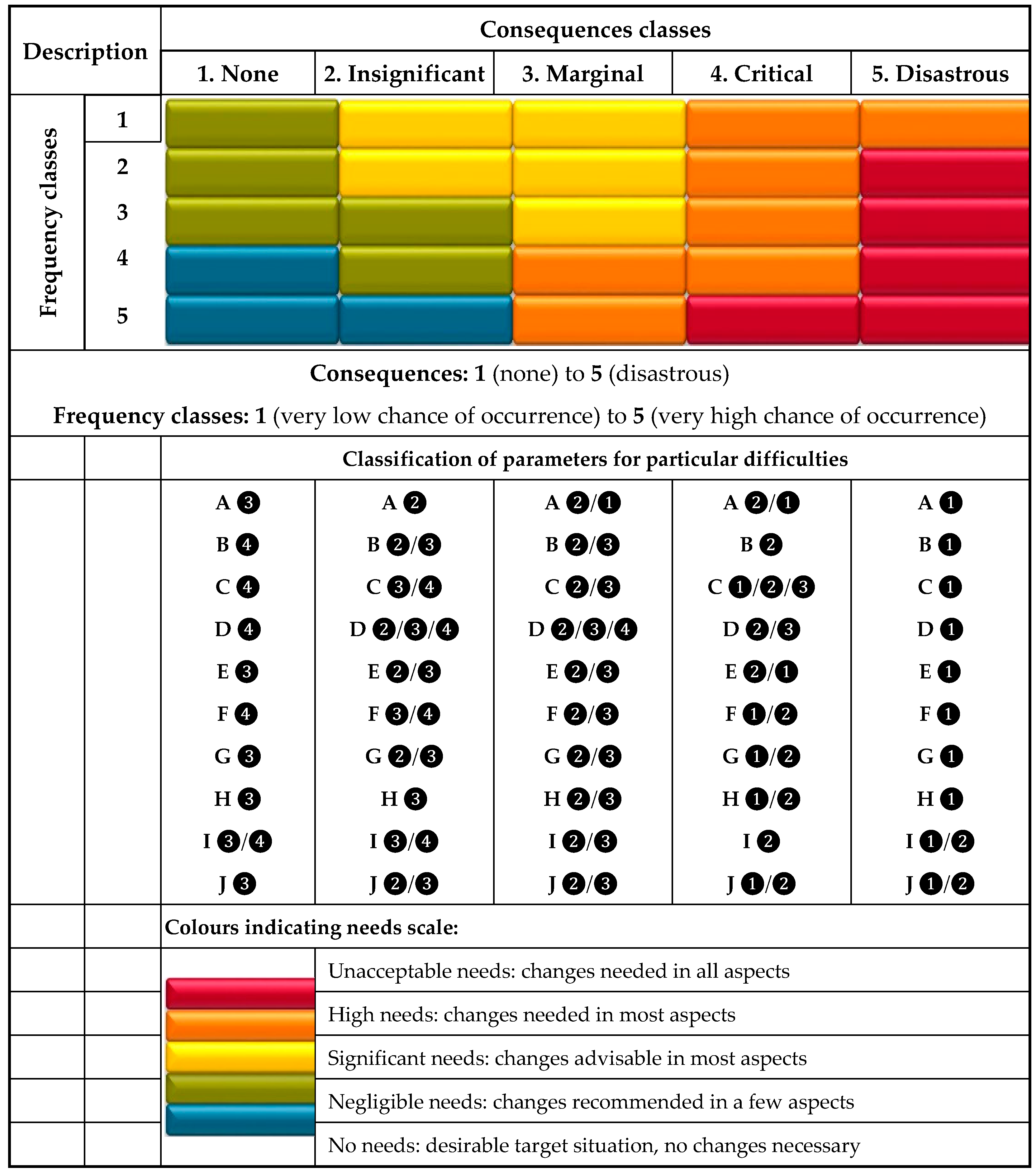
2.4. Needs Matrix for Land Consolidation Activities with Reference to Water Management Needs

Based on the needs assessment matrix with respect to water management needs (Figure 1), the assessment of needs for land consolidation aiming to increase retention can be made in accordance with the following principles:
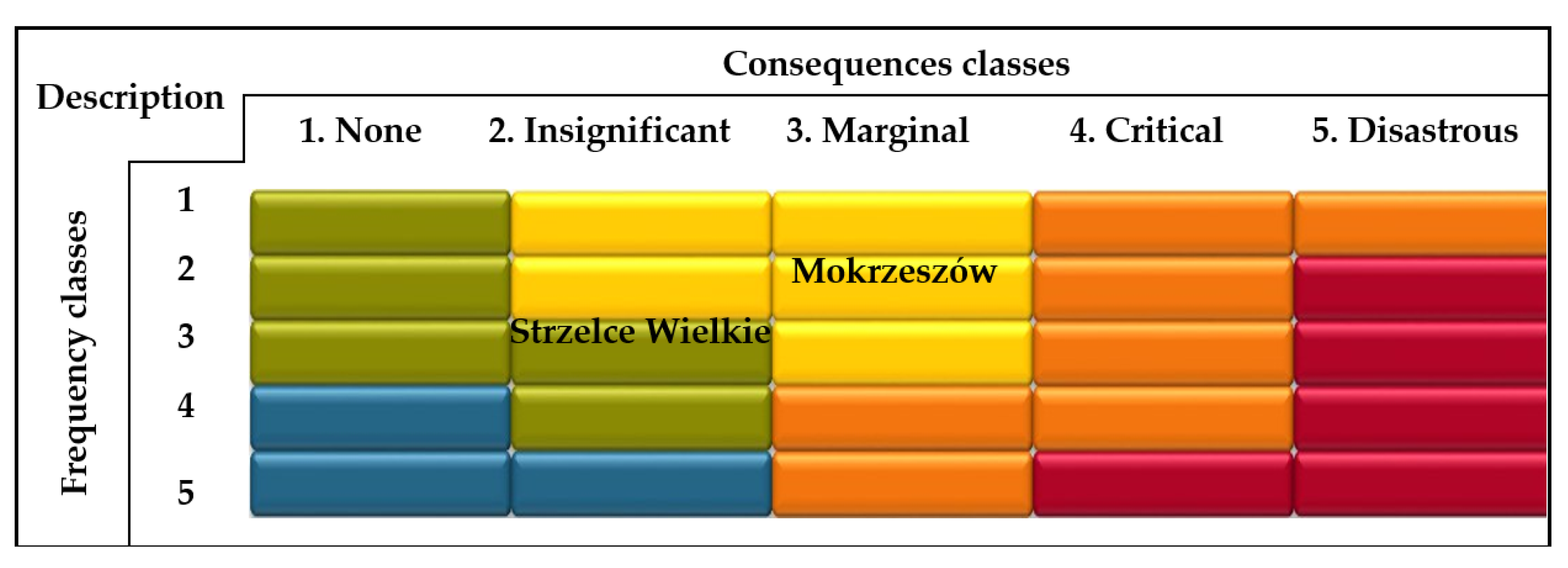
  • A particular site is assigned to the ‘Consequences’ criterion when at least 70% of the analysed indicators take the grade appropriate for a given ‘Consequences’ class;
  • A selection of the likelihood of a given situation is made based on the rating of a given parameter: if >50% of the parameters have a higher rating (❸ or ❹), then a higher likelihood is allocated for that column;
  • Frequency classes are a one-dimensional likelihood of occurrence of each complex parameter, according to the classification shown in the middle part of Figure 1. A frequency value of ‘1′ is associated with a very low chance of the occurrence of complex parameters, while a value of ‘5′ denotes a very high chance of occurrence;
  • The ‘Consequences’ classes describe different categories of impact, and they are ranked from insignificant impact (‘1′) to disastrous impact (‘5′);
  • The matrix feature colours representing five needs scale that show whether the group parameters for a particular site are favourable for water retention. The most favourable option is when the frequency class is ‘5’ and the consequence class is ‘1′. The worst situation is when the parameter values resulted in critical or disastrous consequences;
  • In the matrix, letters ‘A’ to ‘J’ describe the parameters defined earlier. Symbols ❶–❹ indicate the value scale of the parameter.
A similar matrix is commonly used in engineering and water management risk analysis [53].

3. Results and Discussion

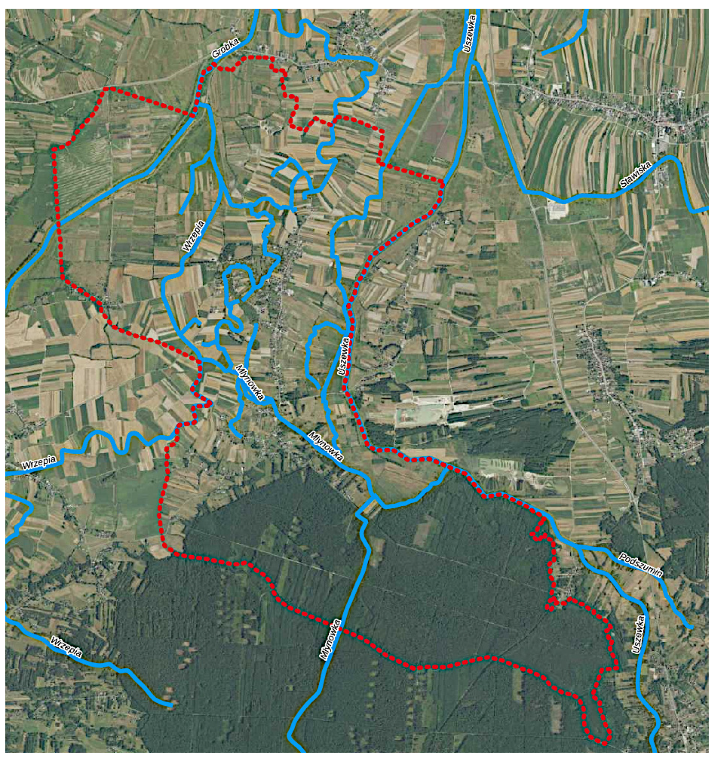
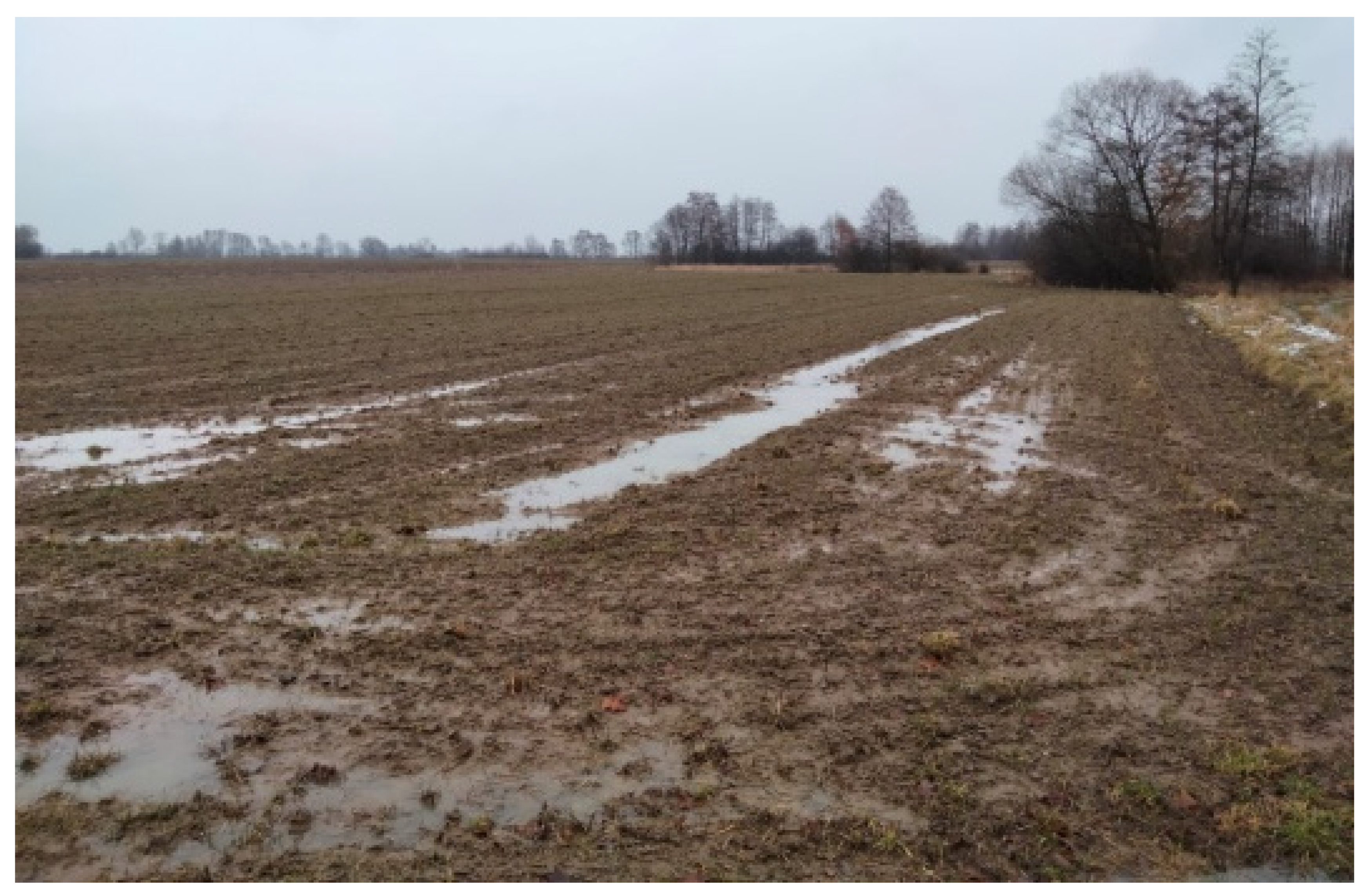
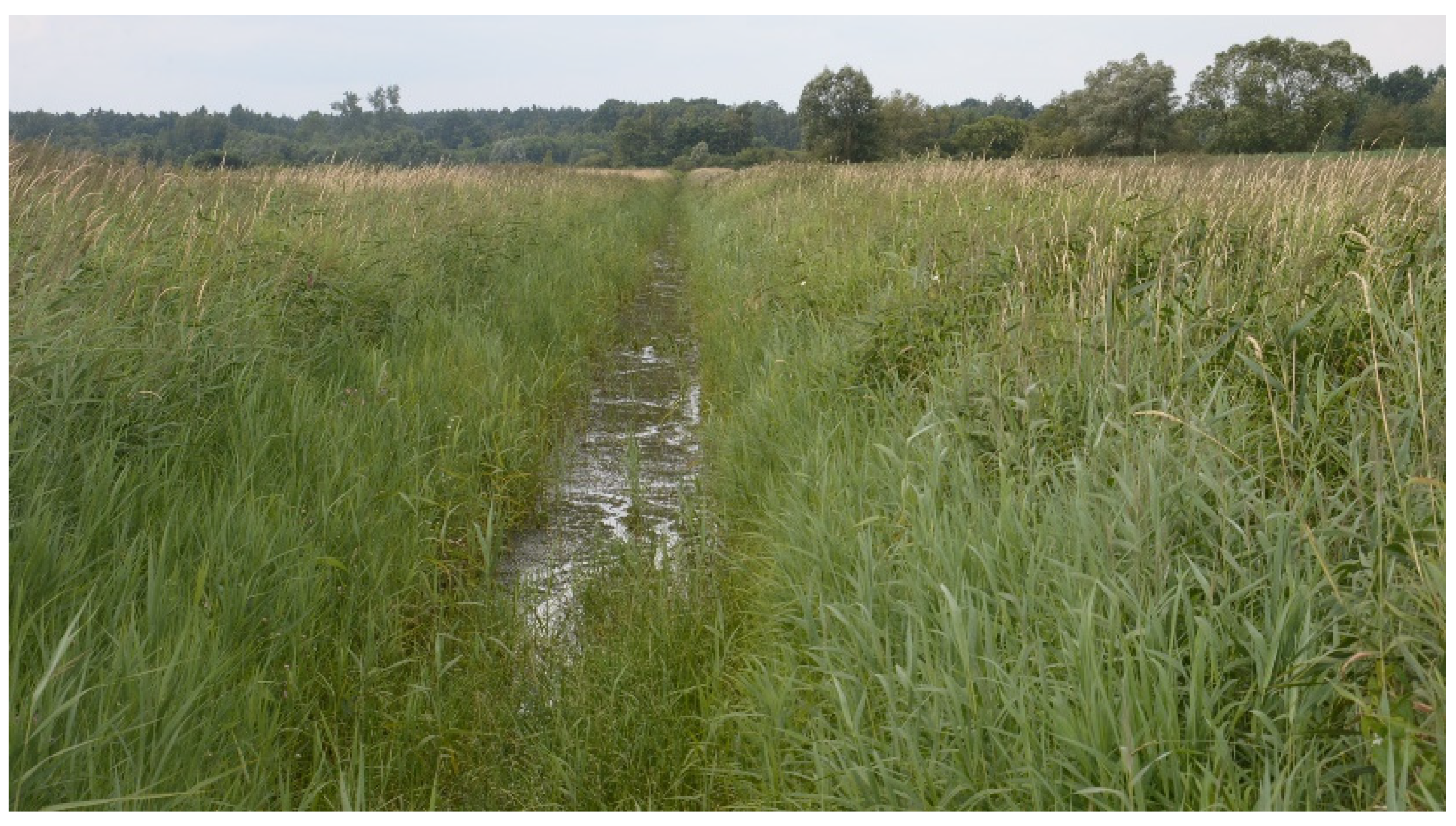
3.1. Characteristics of Sites Selected for Analysis

In developing the assumptions for this land consolidation project, a proposed approach was verified for estimating the water retention needs of two sites located in different parts of Poland and characterised by different spatial structure and water conditions. The Mokrzeszów research site is located in the Świdnica commune in the Lower Silesia province, while the Strzelce Wielkie research site is located in the Szczurowa commune in the province of Lesser Poland.
Table 2 presents the selected parameters of spatial structure of examined sites, while Figure 2 and Figure 3 present fragments of orthophotos showing a typical ownership structure of the sites’ agricultural and built-up areas.
Climate conditions: For Mokrzeszów, the total annual precipitation in the 1971–2000 period was 678 mm, and in the 2001–2010 period, it was 743 mm. On the other hand, the recorded mean annual air temperatures in these periods were 7.4 and 7.8 °C, respectively [54]. Thus, this is a region with mild climate and above-average precipitation relative to the national scale. For Strzelce Wielkie, the total annual precipitation in the 1971–2000 period was 662 mm, and in the 2001–2010 period, it was 719 mm. The recorded mean annual air temperatures in these periods were 8.1 and 8.7 °C, respectively [55]. Thus, it is a warm region with relatively high precipitation [13].
Agricultural land use and soils: Mokrzeszów has been transformed markedly in terms of agriculture, namely, by large-scale farming. The central and northern parts are located at an altitude of 254–310 m and are used for agriculture. The terrain ascends towards the south, where the agricultural space is limited by forest complexes and terrain denivelations. Forests cover 32.95 ha or 2.6% of the area. Good-quality soils prevail in the analysed area. Arable land (AL) dominates over grasslands (GL), the share of which is 89.6% and 10.4%, respectively, in the agricultural area (AA). Permanent grasslands (PG) cover about 7.6% of the area. The entire precinct has a northern slope exposure. In the southern part, which is elevated from 310 to 409 m, there are forests and arable areas, while the local terrain’s descent is 120%.
Strzelce Wielkie has an alluvial plain form, located at approximately 180 m above sea level. The area is flat, with small depressions in the form of oxbow lakes, which are used as GLs. PGs occupy about 30% of the area. In the northern and central sections of the examined area, we can find mud and grey mud in the lower parts. Brown soils dominate in the southern area of the site. Therefore, Strzelce Wielkie, in general, has quite fertile soils with high retention potentials and low risks of soil drought; however, due to the valley’s location and low permeability, they are often exposed to excessive moisture [13].
Water and melioration aspects: Within Mokrzeszów, there are two watercourses with a medium degree of transformation: Milikówka and Lubiechowska Woda, which are right-bank tributaries of the Pełcznica River, in the Bystrzyca River catchment, associated with the Odra River system (Figure 4). Milikówka drains the southern and eastern parts of Mokrzeszów, while Lubiechowska Woda drains its western and northern parts. These watercourses flow in a typically agricultural area, and their course has been adapted to the arrangement of agricultural fields. For this reason, in Figure 4, not only curved, but also straight sections of rivers, can be found. As a result of the regulation, the originally existing natural (winding) course of watercourses has been significantly simplified. Transformed flowing waters do not privilege the creation of a proper biological and hydromorphological balance. For this reason, revitalization works were carried out consisting in widening the migration area and creating buffer zones between the watercourses and the surrounding agricultural fields.
Both watercourses flow in channels protected by buffer zones, which have good influence on the water interactions in this area of influence. Moreover, there are several natural and artificial water reservoirs and ponds in the area.
The total length of melioration ditches in Mokrzeszów is 35.09 km. Drainage has been installed mainly in Mokrzeszów’s northwestern part, where AL occurs. The area of the drained land is 283.38 ha, meaning that it covers about 21.8% of the precinct’s AA.
The Gróbka River and its tributaries—the Wrzępski and Młynówka Creeks—flow through the site of Strzelce Wielkie (northeastern part of the village). The Uszewka channel runs along the eastern boundary of the village (Figure 5).
Figure 5 shows natural and artificial watercourses connected to the land irrigation system, as well as reaches intended for revitalization within the existing system. Compared to the Mokrzeszów village in Strzelce Wielkie, no such strong transformations were made, aimed at adapting the area to achieve the optimal shape of agricultural acreages. For this reason, many oxbow lakes have been left here, suitable for adaptation in the revitalized river network.
The channels of the Gróbka, Uszewka, and Wrzępski Creeks are regulated, and the Gróbka River and the Uszewka channel are embanked. The Młynówka channel, on the other hand, has preserved its natural course with considerable winding. In the central part of the village, in the middle reaches of the Młynówka Creek, there is a large inactive water reservoir that is marshy and overgrown, with water plants and bushes, due to the water being cut off from the Młynówka Creek and directed to the Uszewka channel. In the central and northern part of Strzelce Wielkie, there are small reservoirs of still water, while throughout the village, there is a dense network of drainage ditches with a total length of over 65 km, of which about 52 km requires renovation and maintenance.
In the forest areas, the entire ditch network, totalling 13 km, also needs restoration. There is a large discharge of water from these areas, which periodically floods the AA, contributing to moisture in the soil and deterioration of water conditions. The existing ditch drainage network system is not working, especially in the village centre. As a result, it does not fully provide either the drought protection function or flood risk reduction. Water flow is mainly from the south to north direction. Due to a small catchment area of the Młynówka and Wrzępia Creeks, the flow in these watercourses may subside, which is associated with accelerated plant succession.
Much of the AA in the northeastern and eastern part of Strzelce Wielkie has been drained. Nevertheless, there are wetlands that are exposed to the periodical stagnation of water. The presence of such areas is mainly due to poor technical conditions of the significant part of ditches and drainages, limiting mechanical farming options and, consequently, causing arable land lying fallow [13].
Environmental aspects. Mokrzeszów contains the Ksiazanski Landscape Park, while Strzelce Wielkie contains the Bratucicki Protected Landscape Area and the Gróbka River Valley Special Area of Habitat Protection PLH 120067. This area has very high environmental and cultural potentials. With both examined locations, the course of the agriculture–forest border is mostly regular, but there are no buffer zones at the interface with AL. Additionally, in the examined locations, there are no planned ecological corridors, windbreak tree belts, or degraded land that would require recultivation [13].

3.2. An Assessment of Needs for Retention Measures in the Framework of Land Consolidation

Table 3 presents the analyses of parameters calculated for Mokrzeszów. The weighted mean CN was 82, which indicates a high capacity for direct runoff from rainfall. This is due to the prevalence of AL over other forms of land use, with lower retention capacities than, for instance, meadows or woodlands. Moreover, a significant portion of AA is located in soils with lower-than-average soil permeability according to the USDA [28], which limits its absorptive capacity relative to the infiltrating atmospheric precipitation. Therefore, with respect to CN, the Mokrzeszów area has poor retention capacities.
To evaluate the agricultural drought threat, CWB was calculated. From the agricultural production point of view, for the warm half of the year, its mean value was −35.0 mm, which points to relatively small precipitation deficits. Its value was determined based on the CWB maps included in the Agricultural Drought Monitoring System (SMSR) in Poland, which are available at (https://susza.iung.pulawy.pl/kbw/2021,14/, accessed on 25 April 2021). According to the ‘Plan to counteract the effects of drought’ [35], Mokrzeszów is located in a region where the probability of exceeding annual CWB values below −150 mm is about 10%. In other words, on average, every 10 years, rainfall supply deficits may be expected, which indicates an increased need for irrigation facilities as far as counteracting the effects of agricultural drought is concerned. It should be mentioned, however, that the land’s topography, expressed by average slopes, supports the increase in retention, as they are relatively small and amount to 7.48%. Although, in terms of land use and soil properties, there are negative conditions for retaining precipitation on site, a relatively flat terrain in the central and northern parts is conducive to retarding the runoff, which further enables the use of technical infrastructure in helping to regulate water cycles in the soil.
Given that Mokrzeszów is marked by a high proportion of AL, a large number of water and melioration facilities have been designed in this area. There are drainage and irrigation facilities that enable the complete regulation of water conditions in the soil—in the period of precipitation excesses and deficiencies. These solutions compensate for the relatively unfavourable retention conditions of the studied area, which is evidenced by the high CN. In the period of excess precipitation, the melioration system drains water efficiently. On the other hand, in the period of rainfall deficits, the outflow from these systems can be delayed by a system of gates and damming structures, which reduces rainfall deficits for agricultural crops. Therefore, the D-parameter achieved the highest score in this category.
Nevertheless, for melioration systems to work and benefit water management in the catchment, they need to be maintained properly. In Mokrzeszów, 20% of the facilities are in good condition, 30% are in acceptable condition, and 50% are in poor condition (Figure 6). Finally, the level of maintenance of the melioration system was assessed as acceptable. To improve water interactions inside the AA, it is necessary to maintain correct technical parameters with respect to the drainage ditches. This will promote the efficient drainage of excess water during periods of intense rainfall and reduce the risks of overflows and floods.
A vital element in increasing water retention in the catchment and delaying the runoff is channel retention. Moreover, a well developed system of watercourses with considerable winding is conducive for improving habitat conditions for aquatic organisms. Due to property ownership issues, a network of cultivated fields fits very tightly into the system of drainage ditches. Therefore, the only possible measure is to create buffer strips. One possibility to increase channel retention is to change the shape of the cross-section by reducing the slope’s inclination; however, the effect of these measures interferes with the structure of the watercourse channel. Taking into account the described conditions, the channel retention of Mokrzeszów is insufficient and has been assessed as ‘low’.
The watercourses flowing through Mokrzeszów are not embanked, which means that there are no restrictions on valley retention. Therefore, this parameter scored the highest rating. The lack of embankments along the watercourses allows water to spill over during a flood wave, which leads to its flattening and to the protection of built-up areas from flood damage. In addition, the provision of periodic flooding of the river valley has a beneficial effect on water-dependent ecosystems and the transportation of post-flood substances from the floodplain terraces to the river channel, which has a beneficial effect on aquatic organisms [56].
The amount of water retention in a catchment is also determined by the proportion of sealed areas such as roads, densely built-up areas, or industrial areas. The reduction in permeable surfaces reduces the infiltration of water into the soil, while the use of artificial drainage alters or replaces natural channels. Impervious surfaces increase the danger of increased discharge and decrease the filtration rate [57]. In the case of Mokrzeszów, the proportion of sealed land in the entire area is 8.09%, which classifies it as a continuous build-up area. This is an indirect assessment, as continuously built-up areas are characterised by a high share of sealed areas, yet possess a share of biologically active terrains where the infiltration of precipitation into the ground does take place, thus reducing the intensity of runoffs into watercourses and drainage systems [58,59].
In the case of Mokrzeszów, there is an insignificant degree of involvement of buffer zones due to a small number of watercourses that have such zones, and in the case of drainage ditch networks, no such zones have been observed. Moreover, unevenly distributed, sparse linear forestation was observed on the inspected site.
The last parameter considered in the analysis is the layout of plots. The analysis carried out for Mokrzeszów revealed an average of 0.89 registered plots per ha, which will limit the biodiversity of the area and accelerate the outflow of water due to a small number of baulks on the one hand. This is further evidenced by the lack of numerous buffer zones in the form of woodlots. On the other hand, it is favourable from the land consolidation point of view due to fewer owners, resulting in simpler land acquisition negotiations regarding channel retention measures.
Finally, based on the analysis of parameters, the Mokrzeszów site was classified as a location with significant risks of problems connected with water resources management (Figure 7). This is mainly associated with the site’s low retention capacity, unfavourable water balance from the water, and drainage infrastructure, resulting in water deficits for agriculture, the inappropriate maintenance of drainage systems, and the insufficient retention capacity of river channels. The consequences of this formation of water resources are ‘Marginal’, mainly due to the presence of complex irrigation and drainage systems, a favourable land configuration that compensates for the effects of the lower retention capacity of the soil, a high valley retention capacity, and a continuous type of build-up. Ongoing investments in the maintenance and upkeeping of drainage systems should be pursued with respect to this case study. Moreover, the use of incentives for farmers to implement more buffer strips should also be pursued.
Table 4 presents the analyses of parameters calculated for the Strzelce Wielkie locality. For this site, the weighted mean CN was 66.1, which implies an average capacity in producing direct runoffs from rainfall. This is due to the predominance of meadows over other forms of land use and a relatively large share of forests. Such a significant share of these land uses compensates for the less favourable influence of arable land on runoff formations. Moreover, >90% of the AA is located on soils with good permeability, according to the USDA [28]. Therefore, in terms of CN, Strzelce Wielkie has good retention capacities.
The CWB is +55.0 mm, which means the predominance of supplies over precipitation losses due to evapotranspiration. Therefore, in terms of agricultural drought risk, the area in question is in a favourable situation regarding agricultural production. According to the ‘Plan to counteract the effects of drought’ [35], Strzelce Wielkie is located in a region where the likelihood of exceeding an annual CWB < −150 mm is up to 5%; in other words, precipitation supply deficits may be expected every 20 years, on average. It should be mentioned, however, that the average slope of the terrain favours an increase in retention because it is relatively small and amounts to 6.97%.
In Strzelce Wielkie, AL makes up 39% of the area, which means water conditions in the soil must be regulated by using land melioration facilities. Drainage and irrigation facilities have been identified at the site, enabling the full regulation of water conditions in the soil during periods of precipitation surplus and deficiency. In Strzelce Wielkie, drainage ditches constitute a network of about 65 km in length, while the drained areas make up 7% of the AL. Only 16% of the drainage facilities are well-maintained, whereas as much as 84% are poorly managed (Figure 8). The poor maintenance of melioration facilities will result in an inadequate capacity of the drainage system in taking out excess water, making it a detriment to agricultural production.
The network of watercourses in Strzelce Wielkie is very diverse (Figure 5), resulting in the highest rating given to the ‘channel retention’ parameter. The area is situated at the fork of the Uszewka and Gróbka watercourses. The area contains Stara Młynówka, with a number of drainage ditches, which increase the catchment’s retention. The dense network of watercourses, in combination with technical measures (gates at junctions), enables delaying the outflow and maximising channel retention. Land development enables alterations to the length of the watercourses by extending their horizontal system (meandering). Additionally, declogging Stara Młynówka would enable the restoration of its meandering course.
Strzelce Wielkie is located between the Uszewka and Gróbka watercourses, which have been embanked. Most watercourses in the area, however, have not been embanked, which implies that the floodplains are wide, and this has a positive effect on the valley’s retention.
Sealed areas make up 2.6% of Strzelce Wielkie; hence, it is classified as a discontinuous build-up area. This is a favourable assessment because such areas have a dominant share of biologically active terrains where precipitation infiltrates the ground, thus reducing the intensity of outflow to watercourses and drainage systems.
Along most of the watercourses in Strzelce Wielkie, there are naturally formed buffer zones of varying widths. In addition, point and linear woodlots of various lengths have been identified along parts of the ditches and field roads and also along field boundaries. The buffer strips are evenly distributed across the area. Shrubs and afforestation have been observed in the oxbow lakes. Strzelce Wielkie, therefore, achieved the highest score for this parameter.
The average number of plots in Strzelce Wielkie was 1.57 per ha (Table 4). In contrast to Mokrzeszów, possessing such a number of plots is favourable in terms of biodiversity and outflow delays, although it is not favourable in terms of cultivation and ownership issues. Undertaking pro-retention measures involving watercourses or drainage facilities is easier when there are fewer plots.
Based on the analysis of the selected parameters describing aquatic interactions, Strzelce Wielkie was classified as an area with insignificant risks of problems related to water resources (Figure 7); this was mainly associated with the poor maintenance of melioration facilities and the insufficient retention capacity of river valleys. The consequences of the present situation concerning the structure of water resources are ‘Insignificant’. Only ongoing investments in the maintenance and upkeeping of drainage systems should be pursued for the investigated site.
The main parameters that determined lower needs of water resource management in Strzelce Wielkie village are (Table 4): cuve number, CBW, channel retention, and type of land-cover by build up and buffer zones. Lower CN value and higher CWB in Strzelce Wielkie influence higher water storage in soil and, thus, lower risk of agricultural droughts and also influence longer response of catchment on intensity rainfall. The higher channel retention in Strzelce Wielkie can compensate the disadvantage effect of poorer maintenance of meliorative system than occurs in Mokrzeszów village. Negative impact on water resources has sealed areas where infiltration rate of rainfall is poor. In Strzelce Wielkie village, there are much better conditions for infiltration because sealed areas occupy only 2.6% of the village, as compared to Mokrzeszów, where the sealed area is equal to 8.09%. Finally, large buffering zones in Strzelce Wielkie play a significant role in the protection of the river against pollution, regarding mainly nutrients, which can outflow to form arable land, and which also increase the biodiversity of the landscape.
The applied methodology enables the comparison of various objects in terms of a number of parameters defining land consolidation and its impact on their functions and environmental responses. Some of the parameters can be directly interpreted as factors contributing to or counteracting climate change. The analyzed objects are characterized by different specificities from the point of view of channel and valley water retention capacity and melioration facilities. Watercourses flowing in the Mokszeszów village are characterized by low channel retention, which is the result of adjusting their course to the arrangement of agricultural fields. However, the valley retention is greater than in the Strzelce Wielkie village, which allows the water to flood the neighboring farmlands. Strzelce Wielkie, due to the smaller number of heavily transformed waters, has, on balance, a greater channel retention. Regulation works on this structure served as flood protection, which resulted in the reduction of valley retention. As a result of the analysis of the above-mentioned parameters, information was obtained about the conditions prevailing in a given facility and the possibilities of their improvement. For example, in Mokrzeszów, measures should be taken to increase channel retention. This can be achieved by widening the channel migration belts, combined with increasing the curvature of the watercourses. In the Strzelce Wielkie village, by appropriate control of the operation of the in-channel structures, as a flood protection measure, water can be directed to the adjacent fields. This action will affect the use of additional valley retention. Increasing retention in the catchment is part of the fight against climate change. In some aspect, the proposed approach can be used to assess needs of land consolidation for water management in the future climate change projections. It is possible, by using the CWB, that it is only one parameter in this approach linked with meteorologic conditions. Generally, results of this study confirmed strong needs actions to prevent water scarcity and drought in Poland (regarding conditions), where some of studies confirmed a negative effect of meteorological drought on the agricultural sector [60,61].
During the land consolidation process, stakeholder participation played an important role, mainly in the Strzelce Wielkie village. The land consolidation project was prepared with support residents, including farmers and representatives of the Cracow Bureau of Geodesy and Agricultural Land, local authorities and institutions, and NGOs [62]. In the future, studies involving local communities in the process of developing consolidation projects will certainly be subject to extensive scientific research.

4. Conclusions—Final Remarks

In the future, land consolidation should play a greater role in many aspects of the national economy. It takes on a particular role in agricultural areas, where, in addition to the production’s function, the formation of water resources is becoming increasingly important. A proper shaping of the agricultural production space is important for increased water retention, which is particularly relevant with various, often unfavourable, climatic change phenomena. Therefore, a creation of a simple yet comprehensive tool, which allows surveyors to quickly assess the impacts of water management measures, plays an important role in making land consolidation decisions that take water management problems into account.
This paper proposes a simple tool regarding the formation of a needs matrix for water management in agricultural areas, considering not only factors affecting water retention, such as land use, soil, climate conditions, and topography, but also technical and non-technical retention methods, such as water melioration, channel, and valley retention, the presence of buffer strips that enhance biodiversity, and plot layouts. With the proposed matrix, it is possible to take into account all of the aforementioned factors, allowing for a quantitative and qualitative description of the area in view of developing water retention facilities.
The proposed matrix has been modelled on solutions used for flood risk analysis. All parameters used in the matrix are relatively easy to estimate, and they are based on commonly available databases, such as the following: land use, numerical terrain model, soil maps and information from atmospheric drought monitoring, and on the basis of a visual assessment of the condition of technical infrastructure. In order to verify the assumptions made at the matrix design stage, two sites were selected—Mokrzeszów and Strzelce Wielkie—which differ in climate, soil, land use structure, and hydrological conditions. Based on the analysis, each site was given a different assessment of its retention potential, as the sites exhibited different factors influencing them, including the inadequate maintenance of drainage systems and insufficient retention capacity of river channels and valleys. It can be concluded that the criteria showing the factors influencing water retention have been selected correctly, and the assumptions adopted in the matrix make it sensitive to changes in factors that influence retention. It can be said that the limitation of the proposed method may be the subjective view in the evaluation of some parameters, such as channel and valley retention, or the conditions of drainage facilities. However, the criteria adopted to describe these factors are so simple and unambiguous that an error obtained from the analysis would be acceptable and would not affect the final results.

Author Contributions

Conceptualization, J.M.P. and A.W.; methodology, J.M.P., A.W., L.K. and K.G.; validation, J.M.P., A.W., L.K., A.S., K.G. and J.Z.; formal analysis, A.W., L.K., A.S., M.W. and K.S.; investigation, J.M.P., A.W., L.K., A.S., T.K. and A.B.; resources, J.M.P., A.S., K.G., A.B., M.W. and K.S.; writing—original draft preparation and review and editing, J.M.P., A.W., L.K., J.Z., T.K. and A.B.; visualization, J.M.P., L.K., A.S., T.K., A.B., M.W. and K.S.; supervision, J.M.P. and A.W.; project administration, J.M.P.; funding acquisition, J.M.P. All authors have read and agreed to the published version of the manuscript.

Funding

The research was funded by the operation ‘Environmental and social effects of agricultural and arrangement works in Poland’ and co-financed by the ‘European Agricultural Fund for Rural Development: Europe investing in rural areas’ from the European Union funds under Scheme II of Technical Assistance ‘National Rural Areas Network’ of the Rural Area Development Program for the years 2014–2020 Program Managing Authority—Minister of Agriculture and Rural Development. Co-financing agreement: No. KSOW/4/2020/060.

Institutional Review Board Statement

Not applicable.

Informed Consent Statement

Not applicable.

Data Availability Statement

The data presented in this study are available upon request.

Conflicts of Interest

The authors declare no conflict of interest.

References

  1. Lorig, A.; Ewald, W.G.; Rodig, C.; Bertling, H.; Dielmann, R.; Ebert-Hatzfeld, T.; Franz, K.H.; Gottwald, M.; Hunke-Klein, M.; Kaiser, C.; et al. Strategische Lösungsansätze und Best-Practice-Beispiele zum Thema Hochwasservorsorge. Bund-Länder-Arbeitsgemeinschaft Nachhaltige Landentwicklung (Strategic Solution Approaches and Best Practice Examples on the Subject of Flood Prevention). 2014. Available online: https://www.landentwicklung.de/fileadmin/php_includes/landentwicklung/pdf_doc/Heft22.pdf (accessed on 6 December 2022).
  2. Rodrigues, C.; Fidélis, T. Distinctive features of spatial planning nearby estuaries—An exploratory analysis of water-related rules in municipal master plans in Portugal. Estuar. Coast. Shelf Sci. 2021, 255, 107352. [Google Scholar] [CrossRef]
  3. Hartvigsen, M. Land reform and land fragmentation in Central and Eastern Europe. Land Use Policy 2014, 36, 330–341. [Google Scholar] [CrossRef]
  4. Tan, S.; Heerink, N.; Kruseman, G.; Qu, F. Do fragmented landholdings have higher production costs? Evidence from rice farmers in Northeastern Jiangxi province, PR China. China Econ. Rev. 2008, 19, 347–358. [Google Scholar] [CrossRef]
  5. Kocur-Bera, K. Determinants of agricultural land price in Poland—A case study covering a part of the Euroregion Baltic. Cah. Agric. 2016, 25, 25004. [Google Scholar] [CrossRef] [Green Version]
  6. Lu, H.; Xie, H.; Yao, G. Impact of land fragmentation on marginal productivity of agricultural labor and non-agricultural labor supply: A case study of Jiangsu, China. Habitat Int. 2018, 83, 65–72. [Google Scholar] [CrossRef]
  7. Doehring, K.; Young, R.G.; Robb, C. Demonstrating efficacy of rural land management actions to improve water quality—How can we quantify what actions have been done? J. Environ. Manag. 2020, 270, 110475. [Google Scholar] [CrossRef]
  8. Di Falco, S.; Penov, I.; Aleksiev, A.; van Rensburg, T.M. Agrobiodiversity, farm profits and land fragmentation: Evidence from Bulgaria. Land Use Policy 2010, 27, 763–771. [Google Scholar] [CrossRef]
  9. Ntihinyurwa, P.D.; de Vries, W.T.; Chigbu, U.E.; Dukwiyimpuhwe, P.A. The positive impacts of farm land fragmentation in Rwanda. Land Use Policy 2019, 81, 565–581. [Google Scholar] [CrossRef]
  10. Jongman, R.H.G. Homogenisation and fragmentation of the European landscape: Ecological consequences and solutions. Landsc. Urban Plan. 2002, 58, 211–221. [Google Scholar] [CrossRef]
  11. Clough, Y.; Kirchweger, S.; Kantelhardt, J. Field sizes and the future of farmland biodiversity in European landscapes. Conserv. Lett. 2020, 13, e12752. [Google Scholar] [CrossRef]
  12. Wojewodzic, T.; Janus, J.; Dacko, M.; Pijanowski, J.M.; Taszakowski, J. Measuring the Effectiveness of Land Consolidation: An Economic Approach Based on Selected Case Studies from Poland. Land Use Policy 2021, 100, 104888. [Google Scholar] [CrossRef]
  13. Pijanowski, J.M.; Bogdał, A.; Książek, L.; Wojewodzic, T.; Kowalik, T.; Wałęga, A.; Zarzycki, J.; Zadrożny, P.; Nicia, P.; Strużyński, A.; et al. Środowiskowe i Społeczne Efekty Scaleń Gruntów (Environmental and Social Effects of Land Consolidation); Pijanowski, J.M., Ed.; Uniwersytet Rolniczy w Krakowie: Kraków, Poland, 2021; p. 243. ISBN 978-83-66602-22-9. [Google Scholar] [CrossRef]
  14. Kowalewski, Z. (Ed.) Metody Retencjonowania Wody na Obszarach Rolniczych i Warunki Ich Stosowania (Methods of Water Retention in Rural Areas and Their Conditions of Use); ITP Falenty: Falenty, Poland, 2014; p. 162. ISBN 978-83-62416-82-0. [Google Scholar]
  15. Podhrázská, J.; Kučera, J.; Karásek, P.; Szturc, J.; Konečná, J. The Effect of Land Management on the Retention Capacity of Agricultural Land in the Conditions of Climate Change—Case Study. J. Ecol. Eng. 2021, 22, 258–266. [Google Scholar] [CrossRef]
  16. Przybyła, C.; Sojka, M.; Mrozik, K.; Wróżyński, R.; Pyszny, K. Metodyczne i Praktyczne Aspekty Planowania Małej Retencji (Methodical and Practical Aspects of Small Retention Planning); Bogucki Wydawnictwo Naukowe: Poznań, Poland, 2015; p. 204. ISBN 978-83-7986-057-9. [Google Scholar] [CrossRef]
  17. Glatthard, T.; Amélioration Foncière. Dictionnaire Historique de la Suisse (Land Improvement. Historical Dictionary of Switzerland). 2016. DHS, Version du 29.11.2016, Traduit de L’allemand, Consulté le 12.06.2021. Available online: https://hls-dhs-dss.ch/fr/articles/007847/2016-11-29/ (accessed on 23 January 2021).
  18. Thiemann, K.-H. Fließgewässerrenaturierung in der Flurbereinigung—Anforderungen, planerische Grundlagen und Umsetzung (Watercourse renaturation in land consolidation-requirements, planning principles and implementation). Z. Für Geodäsie Geoinf. Und Landmanagement ZFV 2020, 2, 100–110. [Google Scholar] [CrossRef]
  19. Jiang, S.; Meng, J.; Zhu, L. Spatial and temporal analyses of potential land use conflict under the constraints of water resources in the middle reaches of the Heihe River. Land Use Policy 2020, 97, 104773. [Google Scholar] [CrossRef]
  20. Phan, T.D.; Bertone, E.; Stewart, R.A. Critical review of system dynamics modelling applications for water resources planning and management. Clean. Environ. Syst. 2021, 2, 100031. [Google Scholar] [CrossRef]
  21. Rajda, W. Woda w zagospodarowaniu przestrzennym obszarów wiejskich (Water in spatial development in rural areas). Postępy Nauk. Rol. 2005, 3, 33–42. [Google Scholar]
  22. Mrozik, K.; Przybyła, C. Mała Retencja w Planowaniu Przestrzennym (Small Retention in Spatial Planning); Prodruk: Poznań, Poland, 2013; p. 216. ISBN 978-83-64246-06-7. [Google Scholar]
  23. Brown, G.; Raymond, C.M. Methods for identifying land use conflict potential using participatory mapping. Landsc. Urban Plan. 2014, 122, 196–208. [Google Scholar] [CrossRef]
  24. Teague, A.; Sermet, Y.; Demir, I.; Muste, M. A collaborative serious game for water resources planning and hazard mitigation. Int. J. Disaster Risk Reduct. 2021, 53, 101977. [Google Scholar] [CrossRef]
  25. Peterseil, J.; Wrbka, T.; Plutzar, C.; Schmitzberger, I.; Kiss, A.; Szerencsits, E.; Reiter, K.; Schneider, W.; Suppan, F.; Beissmann, H. Evaluating the ecological sustainability of Austrian agricultural landscapes—the SINUS approach. Land Use Policy 2004, 21, 307–320. [Google Scholar] [CrossRef]
  26. Wojkowski, J.; Młyński, D.; Lepeška, T.; Wałęga, A.; Radecki-Pawlik, A. Link between hydric potential and predictability of maximum flow for selected catchments in Western Carpathians. Sci. Total Environ. 2019, 683, 293–307. [Google Scholar] [CrossRef]
  27. Lojă, C.I.; Niţă, M.R.; Vânău, G.O.; Onose, D.A.; Gavrilidis, A.A. Using multi-criteria analysis for the identification of spatial land-use conflicts in the Bucharest Metropolitan Area. Ecol. Indic. 2014, 42, 112–121. [Google Scholar] [CrossRef]
  28. USDA. Estimation of Direct Runoff from Storm Rainfall. In National Engineering Handbook—Part 630 Hydrology; United States Department of Agriculture USDA: Washington, DC, USA, 2004. [Google Scholar]
  29. Michel, C.; Vazken, A.; Perrin, C. Soil conservation service curve number method: How to mend a wrong soil moisture accounting procedure. J. Water Resour. Res. 2005, 41, 1–6. [Google Scholar] [CrossRef]
  30. Wałęga, A.; Cupak, A.; Amatya, D.M.; Drożdżal, E. Comparison of direct outflow calculated by modified SCS-CN methods for mountainous and highland catchments in upper Vistula Basin, Poland and lowland catchment in South Carolina, USA. Acta Sci. Pol. Form. Circumiectus 2017, 16, 187–207. [Google Scholar] [CrossRef]
  31. Epps, T.H.; Hitchcock, D.R.; Jayakaran, A.D.; Loflin, D.R.; Williams, T.M.; Amatya, D.M. Curve Number derivation for watersheds draining two headwater streams in lower coastal plain South Carolina, USA. J. Am. Water Resour. Assoc. 2013, 49, 1284–1295. [Google Scholar] [CrossRef]
  32. Erhardt, T.M.; Czado, C. Standardized drought indices: A novel univariate and multivariate approach. J. Roy. Stat. Soc. Series C (Appl. Stat.) 2018, 67, 643–664. [Google Scholar] [CrossRef] [Green Version]
  33. Ali, Z.; Hussain, I.; Grzegorczyk, M.A.; Ni, G.; Faisal, M.; Qamar, S.; Shoukry, A.M.; Sharkawy, M.A.W.; Gani, S.; Al-Deek, F.F. Bayesian network based procedure for regional drought monitoring: The Seasonally Combinative Regional Drought Indicator. J. Environ. Manag. 2020, 276, 111276. [Google Scholar] [CrossRef]
  34. Spinoni, J.; Barbosa, P.; De Jager, A.; McCormick, N.; Naumann, G.; Vogt, J.V.; Magni, D.; Masante, D.; Mazzeschi, M. A new global database of meteorological drought events from 1951 to 2016. J. Hydrol. Reg. Stud. 2019, 22, 100593. [Google Scholar] [CrossRef]
  35. KZGW. Projekt Planu Przeciwdziałania Skutkom Suszy w Polsce. Projekt: Opracowanie Planów Przeciwdziałania Skutkom Suszy na Obszarach Dorzeczy (Plan to Counteract the Effects of Drought in Poland), Project no: POIS.02.01.00-00-0015/16, Warszawa. 2020. Available online: http://wide-vision.pl/wp-content/uploads/2020/10/Projekt-PPSS_10-2020.pdf (accessed on 25 April 2021).
  36. Iliopoulou, T.; Aguilar, C.; Arheimer, B.; Bermúdez, M.; Bezak, N.; Ficchì, A.; Koutsoyiannis, D.; Parajka, J.; Polo, M.J.; Thirel, G.; et al. A large sample analysis of European rivers on seasonal river flow correlation and its physical drivers. Hydrol. Earth Syst. Sci. 2019, 23, 73–91. [Google Scholar] [CrossRef] [Green Version]
  37. Harasimowicz, S. Organizacja Terytorium Gospodarstwa Rolnego (Organization of the Territory of the Farm); Akademia Rolnicza im. H. Kołłątaja w Krakowie: Kraków, Poland, 2002; ISBN 83-86524-71-5. [Google Scholar]
  38. Strużyński, A.; Książek, L.; Bartnik, W.; Radecki-Pawlik, A.; Plesiński, K.; Florek, J.; Wyrębek, M.; Strutyński, M. Wetlands in river valleys as an effect of fluvial processes and anthropopression. In Wetlands and Water Framework Directive, GeoPlanet: Earth and Planetary Science; Ignar, S., Grygoruk, M., Eds.; Springer International Publishing: New York, NY, USA, 2015; pp. 69–90. [Google Scholar] [CrossRef]
  39. Żelazo, J.; Popek, Z. Podstawy Renaturyzacji Rzek (Basics of River Restoration); Publisher SGGW: Warszawa, Poland, 2014; p. 308. ISBN 978-83-7583-573-1. [Google Scholar]
  40. O’Driscoll, M.; Clinton, S.; Jefferson, A.; Manda, A.; McMillan, S. Urbanization effects on watershed hydrology and in-stream processes in the Southern United States. Water 2010, 2, 605–648. [Google Scholar] [CrossRef] [Green Version]
  41. Tan, P.Y.; bin Abdul Hamid, A.R. Urban ecological research in Singapore and its relevance to the advancement of urban ecology and sustainability. Landsc. Urban Plan. 2014, 125, 271–289. [Google Scholar] [CrossRef]
  42. Kibii, J.K.; Kipkorir, E.C.; Kosgei, J.R. Application of Soil and Water Assessment Tool (SWAT) to Evaluate the Impact of Land Use and Climate Variability on the Kaptagat Catchment River Discharge. Sustainability 2021, 13, 1802. [Google Scholar] [CrossRef]
  43. Schueler, T.; Brown, K. Manual 4: Urban Stream Repair Practices; Urban Subwatershed Restoration Manual Series; Office of Water Management U.S. Environmental Protection Agency: Washington, DC, USA, 2004. [Google Scholar]
  44. Marshall, E.J.P.; Moonen, A.C. Field margins in northern Europe: Their functions and interactions with agriculture. Agric. Ecosyst. Environ. 2002, 89, 5–21. [Google Scholar] [CrossRef]
  45. Tabacchi, E.; Lambs, L.; Guilloy, H.; Planty-Tabacchi, A.M.; Muller, E.; Décamps, H. Impacts of riparian vegetation on hydrological processes. Hydrol. Processes 2000, 14, 2959–2976. [Google Scholar] [CrossRef]
  46. Ghavasieh, A.R.; Poulard, C.; Paquier, A. Effect of roughened strips on flood propagation: Assessment on representative virtual cases and validation. J. Hydrol. 2006, 318, 121–0137. [Google Scholar] [CrossRef] [Green Version]
  47. Cole, L.J.; Stockan, J.; Helliwell, R. Managing riparian buffer strips to optimise ecosystem services: A review. Agric. Ecosyst. Environ. 2020, 296, 106891. [Google Scholar] [CrossRef]
  48. Dixon, S.J.; Sear, D.A.; Odoni, N.A.; Sykes, T.; Lane, S.N. The effects of river restoration on catchment scale flood risk and flood hydrology. Earth Surf. Processes Landf. 2016, 41, 997–1008. [Google Scholar] [CrossRef]
  49. Stańczuk-Gałwiaczek, M. Planowanie małej retencji wodnej w procesie scalenia gruntów na obszarach wiejskich (Planning of small water retention in the process of land consolidation in rural areas). Woda-Sr. Obsz. Wiej. 2016, 16, 55–69. [Google Scholar]
  50. Koreleski, K. Wpływ czynników terenowych na natężenie erozji wodnej na przykładzie wsi górskiej (The influence of field factors on the intensity of water erosion exemplified by a mountain village). Infrastruct. Ekol. Rulal Areas 2008, 3, 5–12. [Google Scholar]
  51. Józefaciuk, C.z.; Józefaciuk, A. Specyfika urządzania wsi o gruntach zagrożonych erozją (The specificity of arranging villages with land threatened by erosion). Zesz. Probl. Postępów Nauk. Rol. 1992, 401, 219–229. [Google Scholar]
  52. Auerswald, K. Landnuzung und Hochwasser (Land use and floods). In Rundgespräche der Kommission für Ökologie, Bd. 24; Verlag Dr. Friedrich Pfeil: München, Germany, 2002; pp. 67–76. ISBN 3-89937-002-3. ISSN 0938-5851. [Google Scholar]
  53. Mark, O.; Paludan, B. Climate change and urban water systems. In Handbook of Engineering Hydrology; Eslamian, S., Ed.; CRC Press: Boca Raton, FL, USA, 2014; pp. 87–111. [Google Scholar]
  54. GUS. Ochrona Środowiska 2020 (Environmental Protection 2020); Główny Urząd Statystyczny GUS: Warszawa, Poland, 2020. Available online: https://stat.gov.pl/obszary-tematyczne/srodowisko-energia/srodowisko/ochrona-srodowiska-2020,1,21.html (accessed on 30 November 2020).
  55. Praskievicz, S.; Luo, C. Assessment of flow-ecology relationships for environmental flow standards: A synthesis focused on the southeast USA. Hydrol. Sci. J. 2020, 65, 571–582. [Google Scholar] [CrossRef]
  56. Skalski, T.; Kędzior, R.; Radecki-Pawlik, A. Riparian ground beetles in gravel bed rivers: Validation of Invertebrate Bankfull Assessment method. Sci. Total Environ. 2019, 707, 135572. [Google Scholar] [CrossRef]
  57. Li, X.; Fang, X.; Gong, Y.; Li, J.; Wang, J.; Chen, G.; Li, M.H. Evaluating the road-bioretention strip system from a hydraulic perspective—Case studies. Water 2018, 10, 1778. [Google Scholar] [CrossRef] [Green Version]
  58. Zevenbergen, C.; Cashman, A.; Evelpidou, N.; Pasche, E.; Garvin, S.; Ashley, R. Urban Flood Management; CRC Press: London, UK, 2010; p. 340. [Google Scholar] [CrossRef]
  59. Kubiak-Wójcicka, K.; Pilarska, A.; Kamiński, D. The Analysis of Long-Term Trends in the Meteorological and Hydrological Drought Occurrences Using Non-Parametric Methods—Case Study of the Catchment of the Upper Noteć River (Central Poland). Atmosphere 2021, 12, 1098. [Google Scholar] [CrossRef]
  60. Bokwa, A.; Klimek, M.; Krzaklewski, P.; Kukułka, W. Drought Trends in the Polish Carpathian Mts. in the Years 1991–2020. Atmosphere 2021, 12, 1259. [Google Scholar] [CrossRef]
  61. Ziernicka-Wojtaszek, A. Summer Drought in 2019 on Polish Territory—A Case Study. Atmosphere 2021, 12, 1475. [Google Scholar] [CrossRef]
  62. Czarnecka, A.; Krupowicz, W. Partycypacja społeczna w scaleniach gruntów oparta na idei crowdsourcingu—doświadczenia z wykorzystania aplikacji na urządzenia mobilne LC-CApp (Public participation in land consolidation process based on the idea of crowdsourcing-experience from the use of LC-CApp for mobile devices). Przegląd Geod. 2022, 94, 9–15. [Google Scholar] [CrossRef]
Figure 1. The needs matrix for land consolidation activities with reference to water management needs (own study). The numbers and letters are explained in Table 1.
Sustainability 14 16651 g001
Figure 2. Example of a typical ownership structure of agricultural and built-up areas in Mokrzeszów (source: Dolnośląskie Biuro Geodezji i Terenów Rolnych, Poland, http://dbgitr.pl/, accessed on 6 December 2022).
Sustainability 14 16651 g002
Figure 3. Example of a typical ownership structure of agricultural and built-up areas in Strzelce Wielkie (source: Krakowskie Biuro Geodezji i Terenów Rolnych, Poland, https://www.kbgitr.com.pl/, accessed on 6 December 2022).
Sustainability 14 16651 g003
Figure 4. Overview map of the flowing water locations in Mokrzeszów (own study) Markings: blue lines—flowing waters, red dotted lines—administrative boundary.
Sustainability 14 16651 g004
Figure 5. Overview map of the flowing water locations in Strzelce Wielkie (own study) Markings: blue lines—flowing waters, red dotted lines—administrative boundary.
Sustainability 14 16651 g005
Figure 6. Excessive moistening of fields in Mokrzeszów caused by ill-functioning drainage ditches (photo: T. Kowalik).
Sustainability 14 16651 g006
Figure 7. Results matrix of water retention needs in the Mokrzeszów and Strzelce Wielkie land consolidation framework (own study).
Sustainability 14 16651 g007
Figure 8. An example of poor maintenance of a drainage ditch in Strzelce Wielkie (photo: T. Wirth).
Sustainability 14 16651 g008
Table 1. Parameters adopted for the analysis of land consolidation in relation to water management needs (own study).
ParameterRanges Adopted for Testing
A. Curve number (CN)❶ >81
❷ 51–80
❸ <50
B. Climatic Water Balance (CWB)❶ <−150 mm
❷ −150–0 mm
❸ 0–150 mm
❹ >150 mm
C. Mean slope (S)❶ >25%
❷ 17–25%
❸ 10–17%
❹ 0–10%
D. Melioration facilities❶ none
❷ irrigation only
❸ drainage only
❹ irrigation−drainage
E. Maintenance status of meliorative systems❶ poor
❷ acceptable
❸ good
F. Channel retention/meandering❶ none
❷ low
❸ average
❹ high
G. Valley water retention❶ narrow floodplains
❷ wide floodplains
❸ unrestricted (no embankment)
H. Type of land-cover by build-up❶ industrial (commercial)
❷ continuous
❸ discontinuous
I. Buffer zones❶ none
❷ insignificant
❸ satisfactory rate
❹ large numbers
J. Layout of land plots❶ many, small, and irregular
❷ few and with regular shapes
❸ average number of plots
Table 2. Selected parameters of spatial structure of the examined research sites.
SpecificationMokrzeszówStrzelce Wielkie
Land consolidation area (ha)1716.001708.00
Number of farmlands80.00262.00
Number of participants517.00818.00
Number of land plots1532.002698.00
Average number of plots per farmland7.006.55
Average plot size of the farmland (ha)1.380.45
Own study based on Pijanowski et. al. [13].
Table 3. Results of the parameters included in the risk/needs assessment matrix for water management measures for Mokrzeszów (own study).
ParameterValueParameter Classification
A. Curve number (CN)82
B. Climatic water balance (CWB)−35 mm
C. Mean slope (S)7.48%
D. Melioration facilitiesirrigation–drainage
E. Meliorative systems’ maintenance statusacceptable
F. Channel retention/meanderinglow
G. Valley water retentionunrestricted
H. Type of land-cover by build-up8.09% sealed
I. Buffer zonesinsignificant
J. Layout of land plots0.89 plot per ha
Table 4. Parameter results included in the risk/needs assessment matrix for water management measures for Strzelce Wielkie (own study).
ParameterValueParameter Classification
A. Curve number (CN)66.1
B. Climatic water balance (CWB)+55 mm
C. Mean slope (S)6.97%
D. Melioration facilitiesirrigation–drainage
E. Meliorative systems’ maintenance statuspoor
F. Channel retention/meanderinghigh
G. Valley water retentionwide
H. Type of land-cover by build-up2.6% sealed
I. Buffer zonesLarge number
J. Layout of land plots1.57 plots per ha
Bold are marked parameters that determined different results in matrix for both locations.
Publisher’s Note: MDPI stays neutral with regard to jurisdictional claims in published maps and institutional affiliations.

