
Ship Graffiti in Horologion of Andronikos Kyrristos, Greece: A Comparative Study and New Evidence
by
 , ,
, ,
Evangelia Panou
1,
Agathi Anthoula Kaminari
1,
Georgios Tsairis
1 and
Athina Georgia Alexopoulou
2,* 1
Department of Conservation of Antiquities and Works of Art, University of West Attica, 12243 Egaleo, Greece
2
ARTICON Lab: Conservation Promotion of Visual Arts, Books and Archival Material, Faculty of Applied Arts and Culture, Egaleo Park Campus, University of West Attica, 12243 Egaleo, Greece
*
Author to whom correspondence should be addressed.
Sustainability 2022, 14(21), 13791; https://doi.org/10.3390/su142113791
Submission received: 25 August 2022
/
Revised: 11 October 2022
/
Accepted: 19 October 2022
/
Published: 24 October 2022
(This article belongs to the Special Issue Sustainability in Conservation of Cultural Heritage: An Open Challenge)
Abstract
:The paper contributes new information about the Horologion of Andronikos Kyrristos of the Roman Agora of Athens, Greece and its continuous presence in Athens from antiquity until now. The monument is of cultural, historical and astronomical importance. It has undergone conservation work and non-destructive documentation which contribute to its sustainability. The spectral imaging technique, which allows the acquisition of high-resolution images, was applied on the stone surfaces of the monument. The acquisition of images in the visible and infrared regions, combined with the digital tracing reproduction of the graffiti and image processing, is used for the first time in this particularly interesting case study of the aforementioned monument, of which a complete description is provided. New evidence with a clearer recording of the vessels already mentioned in the literature, as well as the detection of new historical data and graffiti, is discussed in comparison with the results of previous studies.
1. Introduction
1.1. The Horologion of Andronikos Kyrristos
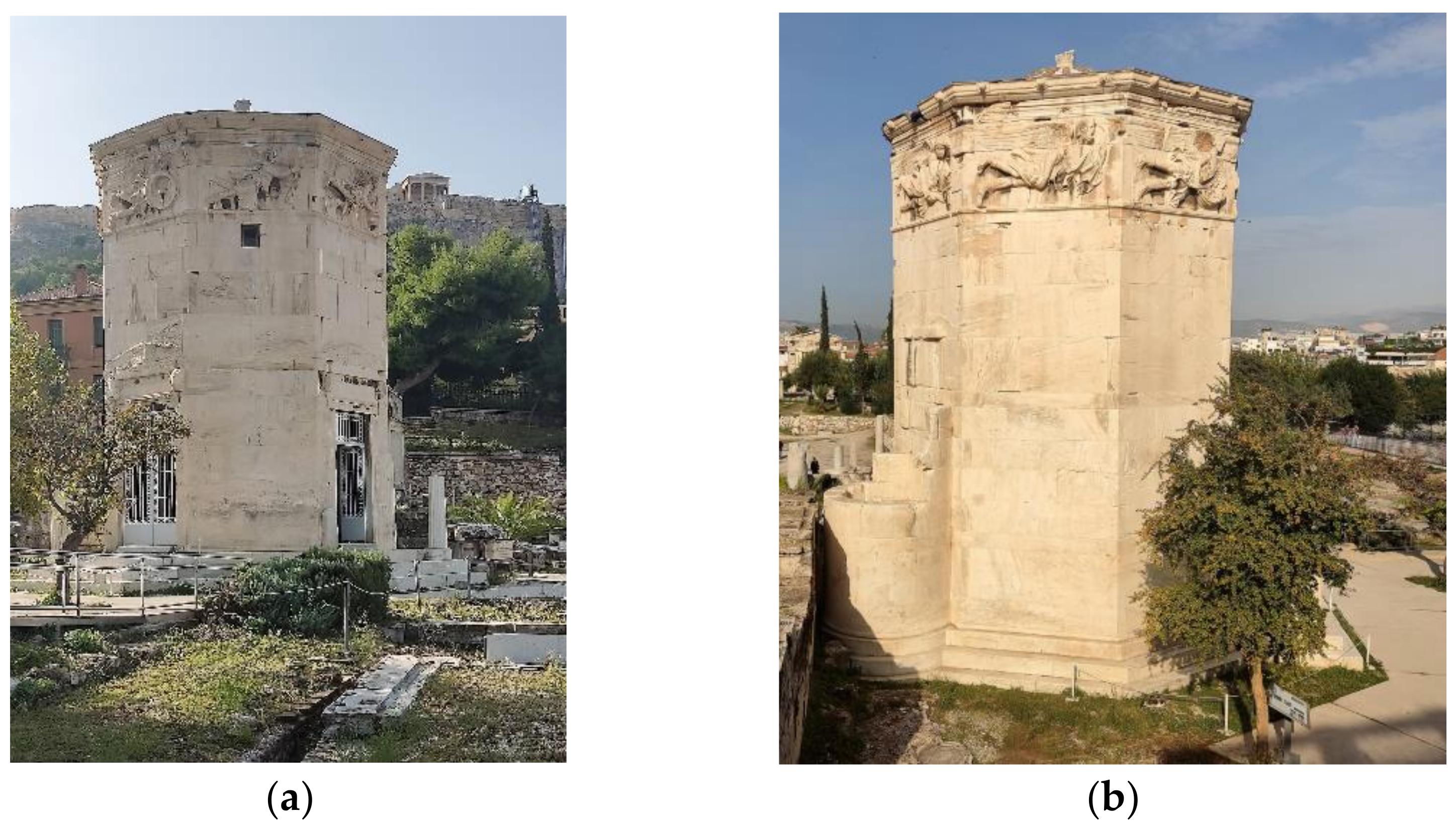
The Horologion of Andronikos Kyrristos is a monument of cultural importance within the historical centre of Athens, Greece. It is located on the north side of the hill at foot of the Acropolis, next to the Roman Agora in Athens (Figure 1). It was built around 100 B.C. by the astronomer Andronikos from Kyrros, Macedonia, who constructed the monument according to the science and cultural knowledge of that era [1,2]. It is a tall (13.5 m), octagon-shaped marble building with a maximum diameter 8.0 m and a semi-cylindrical annex attached on its south side. Each side length is about 3.26 m [3]. Unofficially, the monument is also called the Tower of the Winds, Temple of Aeolus (Aeolus was the god of winds in ancient Greek mythology) or Aerides from the Greek word Aέρηδες, which means winds.
In ancient times, the monument was used as a meteorological and time-measuring station as well as a planetarium [4,5,6,7,8,9]. On the upper external walls of the monument, οn the frieze that ‘runs’ along the monument below the roof, eight marble personified wind deities, one on each wall of the octagon, are depicted. The deities bear the symbols and represent the orientations of the corresponding blowing winds: Boreas (north), Notos (south), Apeliotes (east), Zephyros (west), Kaikias (northeast), Evros (southeast), Lips (southwest) and Skiron (northwest). Below them, eight engraved sundials are mounted. They were used to indicate the time on sunny days throughout the year, whereas a hydraulic mechanism inside the monument was used on cloudy days. Although nowadays there is no surviving mechanism, evidence proves that the mechanism was a planetarium used for astronomical purposes. The monument was also used for ecclesiastical purposes, such as an orthodox church or the baptesterion of an adjacent church [10,11,12,13,14,15,16,17,18,19] and as an Islamic place of worship [13]. In the 19th century, the monument was included in the antiquities of Athens and was used as a temporary museum [20].
The need to tackle the problem of the deterioration the Horologion of Andronikos as a whole has resulted in extensive conservation work on the surfaces of the monument inside as well as outside, as well as in structural reinforcement. The aforementioned treatments were implemented between 2014 and 2015 in the context of the project of the National Strategic Reference Framework 2007–2013 titled ‘Conservation and Valorization of the Horologion of Andronikos Kyrristos, at the archaeological site of the Roman Agora of Athens’; it was initially conducted by the A’ Ephorate of Prehistoric and Classical Antiquities and then followed by the Ephorate of Antiquities of Athens, Ministry of Culture and Sports [3].
Within the frame of this project, new studies and research methods were carried out by ARTICON Lab: Conservation Promotion of Visual Arts, Books and Archival Material of the Faculty of Applied Arts and Culture, University of West Attica, for the comprehensive investigation of the wall’s surfaces, the substrates of the mortars, the underlying paint layers, and the drawings of the decoration, as well as an inorganic materials analysis. This paper refers to the application of imaging techniques for the acquisition of information in the visible and infrared regions, combined with image processing to produce more information. This is used for the first time in this particularly interesting case study of the Horologion of Andronikos Kyrristos in order to bring to light new evidence concerning the clearer recording of vessels that have already been mentioned in the literature as well as the detection of new historical data and graffiti.
At this point, it is necessary to explain why the use of the term graffiti has been adopted. When graffiti began appearing as tags on walls, it had the meaning of verifying that the writer had been to that place [21]. Later it became a means of making known the opinions of people who had no other way of expressing themselves or their political, economic and social status [22]. However, graffiti dates back over a millennium. Originally, graffiti was a term invented by classical archaeologists to describe a very specific kind of inscription: the scribbles that covered the walls of Pompeii [23], and it would include insults, sexual content, political support and visual images. In general, ancient graffiti would refer to shapes, lines, images or texts and conveyed the writers’ messages to their fellow civilians not only about politics but also about mythology, the way they wanted people to remember them, loving or hateful messages, and recreational sketches, using either charcoal or a marking tool to scratch on the surface [24,25]. Bearing this in mind, it now becomes evident that even though the ships’ figures were not part of the original decoration and cannot be called murals, they fall into the category of graffiti. Moreover, the presence of graffiti and the use of the monument for ecclesiastical purposes [10,11,12,13,14,15,16,17,18,19] and as an Islamic place of worship [13], which influenced the humidity and the chemical composition of the atmosphere inside the building, represent a threat to the rock/marble preservation and to the sustainability of the building itself, as all the aforementioned have damaged its original pristine-like surfaces. However, because the graffiti on the walls has been acknowledged as an inseparable part of the monument’s history and identity, we have employed non-destructive imaging techniques to thoroughly study the sketches, so as to further contribute to the scientific knowledge of their origin and purpose. Our non-destructive methodology contributes to the sustainability of the monument. Furthermore, it is mentioned in the literature that non-invasive methods have already been applied for the research and preservation of the sustainability of rock art [26], which supports the present research.
1.2. State of the Art
The novelty of the present study is employing non-destructive imaging techniques that have been traditionally used for paintings and applying them for stone surfaces [27]. Spectral imaging (SI) was the main method applied in this research, which, as an imaging technique, guarantees the safety of the investigated surfaces because it is non-invasive. Photographic documentation was also used to record the surfaces in true colour.
Spectral imaging exploits both visible and near-infrared regions, usually from 400 to 1000 nm, to acquire images. Using an internal combination of filters, it can record the reflectivity response of surfaces at specific wavelengths given by the manufacturer, which results in the acquisition of several singular images, each responding to a particular wavelength [28,29]. This has the major advantage of being able to study the individual behaviours of the surface or the paint layers in different wavelengths, which may lead to better discrimination [30,31,32,33]. Another advantage of single wavelength images is that no matter the background or the surface, there will always be at least one wavelength that will produce high contrast between the background and information to be differentiated.
Apart from the conventional use of spectral imaging for the study of icons [34,35], paintings [36] and manuscripts [37], they have been employed for other kinds of archaeological materials as well, such as papyrus, marble pyxis, ancient lekythoi and ceramics [38].
As spectral imaging systems have limitations, such as short ranges, they are not the first choice for non-movable, large-sized murals, especially when they are located inside or outside monuments and require dedicated artificial illumination systems. In such cases, remote-sensing hyperspectral imaging is used instead [39,40]. However, the present case study of a large-scale monument with stone surfaces pioneered the application of the methods on non-conventional materials, and in the end obtained remarkable results. In the international literature, only a few cases are mentioned regarding the use of spectral imaging for studying archaeological or historical buildings and stone surfaces [41,42,43]. Furthermore, it is worth mentioning that it is the first time that these techniques have been applied systematically and comprehensively for the diagnosis of conservation status, the study of morphology and the detection of historical data on the stone surfaces of the Horologion; however, only the latter will be discussed in the present paper.
This study expanded the potential of these methods; improved the observations of the material; assisted in the discovery of, approach to and interpretation of aspects invisible to the human eye; and proved that these modern non-destructive documentation techniques are rightly regarded as cutting-edge technology in the diagnoses of works of art and monuments [40,44].
It should be mentioned that short wave infrared images (SWIR), false colour infrared images (FCIR) and spectral cubes (SC) were also acquired, but most of our best evidence of the ships resulted from the 800 nm single band images and therefore the aforementioned methods are not presented in this paper.
2. Materials and Methods
One of the goals of the research was to produce results concerning the historical use of the monument. As stated before, modern diagnostic methods were applied, and images were acquired using in situ spectral imaging assisted by normal and macro photography in normal and raking light in the visible and infrared regions.
A hyperspectral detector, MuSIS HS model 2009 (Forthphotonics Hellas S.A. now Dysis, Heraklion, Greece), was used, which was equipped with a CCD 1/200 progressive scan sensor (1600 × 1200 pixels, 8 bits, 15 fps) with 34 selectable spectral bands in the range of 400–1000 nm for B&W and colour imaging. Its standard illumination sources were two Dr. Fischer halogen lamps 500 W with a colour temperature of 3200 Κ (Dr. Fischer GmBH, Germany, bought in Athens, Greece).
Further photographic images were acquired with a FX-format Nikon D800 with a 36.3 megapixel (59.4 × 84.1 cm/200 dpi) CMOS censor (Nikon Corporation, Tokyo, Japan, bought in Athens, Greece), a micro Nikkor 60 mm f/2.8D (Nikon Corporation, Tokyo, Japan, bought in Athens, Greece), and a Νikon AF-S Nikkor Nano Crystal ED with 24–70 mm lenses (Nikon Corporation, Tokyo, Japan, bought in Athens, Greece). The same illumination system was used as with the MuSIS HS.
It must be noted that the majority of images were acquired with the position of the lights at such an angle so as to provide uniform illumination. However, after careful examination of the surface, scratch marks were located and it was decided to acquire extra images using all the techniques in raking light as well, so as to record any further information that might be revealing.
In order to record the stone blocks with an adequate resolution, it was decided the detectors would be up to 1.5 m away from the surface, meaning no image could cover their entire surface. Therefore, depending on the size of each stone block, a grid comprising four, six or nine areas was drawn on paper, facilitating the acquisition of the images and their respective grouping and categorization. Recordings at specific wavelengths (420, 500, 600, 700, 800, 900 and 1000 nm, vis and FCIR) were carried out in all grid sections. All images were stored in a digital format and Adobe Photoshop 2022 (v.23, Mountain View, CA, USA) was used to improve the readability of the sketches.
3. Results
The building itself encourages interdisciplinary research and approaches using non-invasive methods within the framework of the sustainability of cultural heritage. It is the first time that the wall surfaces of this monument have been studied in a systematic and comprehensive way using spectral imaging. Thus, invisible to the human eye, graffiti and drawings were recorded and their documentation followed. The primary material produced, which exceeds 4400 useful images, is unique in terms of its size, quality, originality in the application of the diagnostic methods and huge amount of data. The images were grouped according to the stone block they belonged to and according to the method applied. The documentation of the walls recorded numerous types of graffiti, such as ships, names, numbers, texts, dates and sketches.
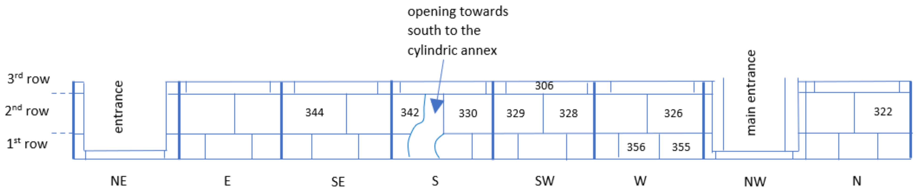
The present study focuses on the three lower rows of stones of the internal north-, west-, south- and southwest-facing walls of the building in which 18 vessels have been revealed using visible and infrared illumination (Figure 2). Two of the ships (1a and 1b) are engraved or scratched on the stones [45] while the remaining 16 ships are drawn with a black medium, possibly charcoal [46,47]. In order to determine the position of the vessels, the stones were assigned numbers, which start from the main entrance of the building and go counter-clockwise.
The first row of stones (the lowest one) consists of stones 348–351, 353–361 and 367–377; the second row of stones (above the first row) consists of stones 321–330 and 342–347; and the third row of stones (above the second row) consists of stones 300–307 and 315–320. In Figure 2, for simplicity of representation, only the stone numbers (306, 322, 326, 328, 329, 330, 342, 344, 355 and 356) where the vessels were recorded are mentioned. The orientation of the walls is also indicated. Moreover, a vessel number is assigned to each ship for identification (Table 1).
Our close in situ observations and study of the acquired images gave us information not only about the sketches but also about the condition of the blocks. In regards to the area where the ships are located on the ground floor, the stones look worn by time. The monument had many uses during its lifetime, which included part of the ground floor being buried [20]. Soil has indeed left its mark by rendering the stone surfaces with different hues of brown. Soot from past lighting as well as black deposits have affected several surfaces, giving them a dark appearance. The ship graffiti is traceable in most cases because of the contrast: the difference between the light colour of the stone surface and the black medium used for painting them. In some cases, however, they are worn by time and dirt deposits and are hard to discern.
The individual images of the grid of each stone were merged to form a final image of the entire block for each individual wavelength. In the present study, these images were cropped to form the ships’ graffiti. The images were also processed minimally, only to show better contrast. Furthermore, because of the difficulty in discerning the graffiti, digital tracing reproduction of the images was applied by copying the ships’ graffiti on a 1:1 scale, processed by the commercial software Adobe Photoshop. The processing resulted both in separating the ship graffiti from the elements belonging to the rough surface of the stones and in producing a digital version of the sketch.
4. Discussion
During a survey of the Horologion of Andronikos conducted in 1998 by H.J. Kienast [45,46], several sketches of vessels were first identified with the naked eye on the internal stone surfaces of the monument. Four years later, Damianidis and Kienast presented a preliminary report of them and a detailed discussion on 12 of the sketches of vessels [45,47]. In 2014 and 2015, ARTICON Lab conducted the aforementioned survey which resulted in the detection of more sketches, among other discoveries.
Damianidis in his work recorded the location of each piece of graffiti in the building without the employment of specialised instruments and made their scale drawings [45]. He referred to each sketch by the name of the wind of the wall, the number of the marble stone and the number of the vessel. He divided the ship graffiti into two groups according to the materials used to draw them: the graffiti scratched onto the marble surface with a pointed tool and the graffiti drawn with charcoal graffiti on the interior marble walls; these terms were also adopted in the present paper. Due to the appearance of both groups of ships, he suggested that they were drawn in completely different historical periods. The first group are drawings from the late Roman period, whereas the second one consists of charcoal graffiti and includes sailing vessels from the recent past. The present paper discusses the comparison of the graffiti presented by Damianidis and the corresponding ones detected by spectral imaging techniques in the visible and the near infrared spectra. We also discuss the detection and presentation of new, important details that are invisible to the naked eye, which helped in understanding and interpreting the graffiti.
4.1. Ancient Ship Graffiti (Stone 344)
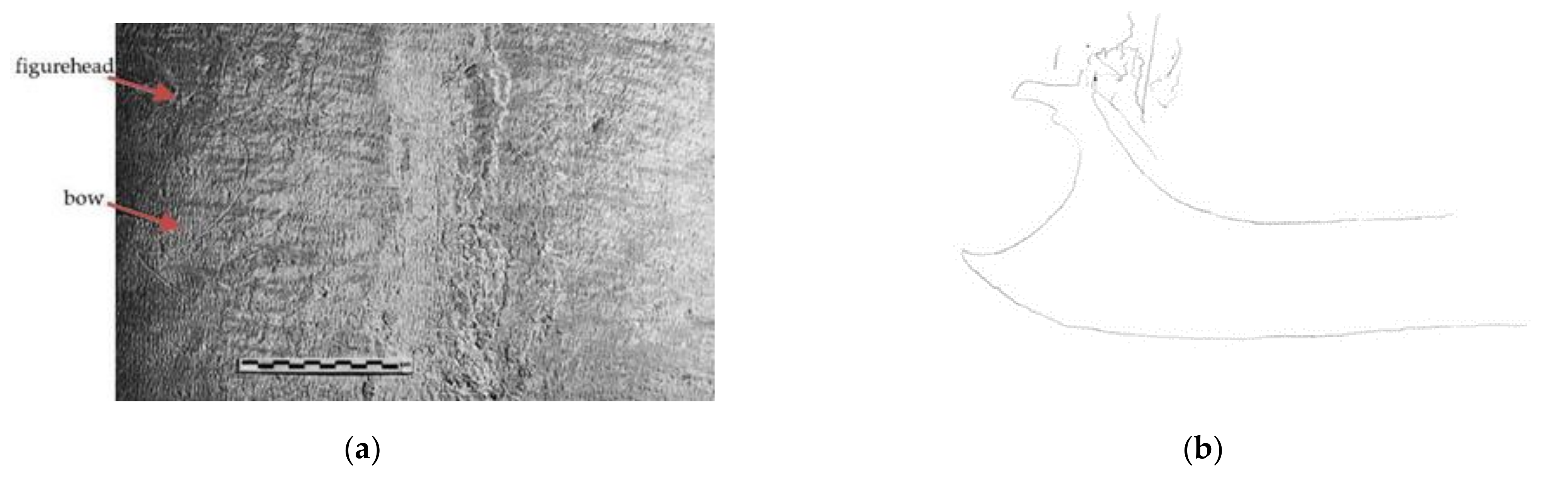
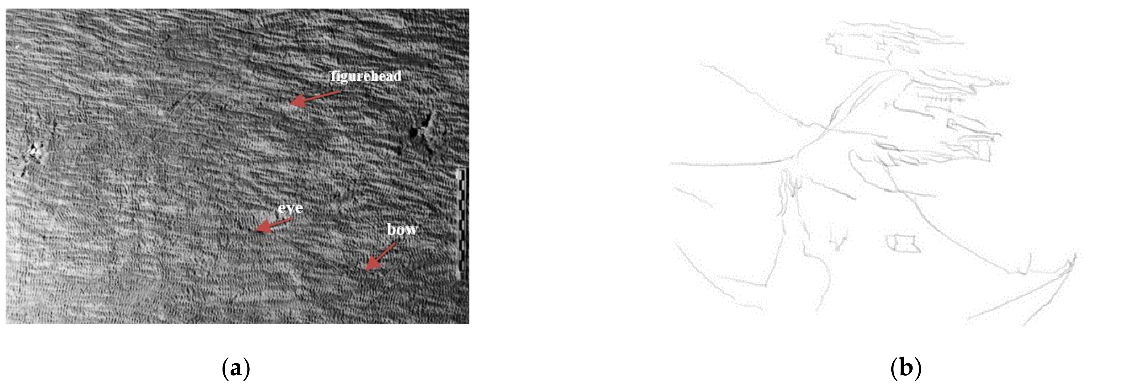
On the lower zone of the southeast-facing wall (Evros wall), on the second row of stones (Figure 2), very thin lines scratched onto marble stone 344 with a pointed tool were recorded with the raking lighting technique. This technique was used so that small contours would be highlighted and long shadows for small protrusions would be produced. The images taken depict two separate grids of carved lines and curves that form a small-sized piece of graffiti (vessel 1a) (Figure 3) and quite a large one, respectively (vessel 1b) (Figure 4 and Figure 5). The large piece of graffiti (1.26 m × 0.45 m) is four times the size of the small one. So, it is likely the small one is a draft for the large one.
The vessels are not likely to be triremes but could be smaller warships or rowed vessels. Vessel 1a is a simple drawing of a rowed vessel that appears to move towards the east. It is engraved onto the marble with a few simple basic lines and curves. Its bow has a very distinctive shape and bears a figurehead that looks like a horse bust (Figure 3).
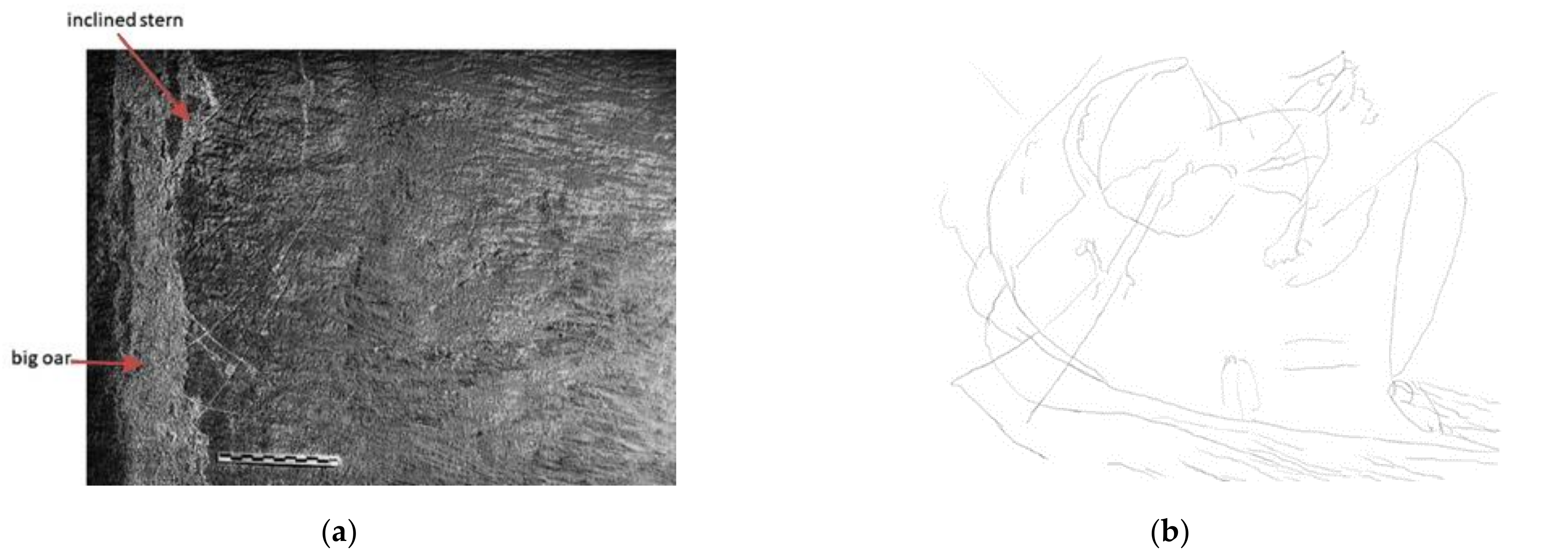
Vessel 1b, appearing to move towards south, is a much larger and more detailed drawing than vessel 1a. It has an oblong hull, an inwardly inclined stern with a big oar used for the navigation of the vessel (Figure 4) and a very distinctive bow that bears a figurehead (looks like a horse bust) in the form of an intimidating animal head (Figure 5). It has just a single, large square sail and a carved eye (or ophthalmos) ornament on the bow, thus making the ship frightening to enemies (Figure 5).
Oared ships, such as triremes and penteconters [48], were sailing in the eastern Mediterranean sea when the ancient Greek and Roman civilizations flourished, respectively [49,50,51,52]. From the 2nd millennium B.C. to the 6th century, eastern Mediterranean vessels had animal-shaped bows and sterns, thus endowing the vessel with a life of its own [53,54]. Vessels of the Bronze Age and of the Archaic, Classical, Hellenistic and Roman periods featured an eye ornament on the bow [53,55,56,57,58]. In merchant ships, the eyes had round shapes (circles) while in rowing ships they were bigger, more natural and more anthropomorphic. The circular eyes were depicted in concentric circles with their gaze facing outwards, so as to protect the ship against evil. The anthropomorphic eyes symbolised the presence of a supernatural consciousness of a god, which navigated the ship to reduce the risk of marine hazards. In addition, the stern of the large-sized vessel (vessel 1b) has several similarities with the stern on which the southwest wind deity Lips leans. Although vessel 1b was not recorded on the southwest-facing wall, it could be documented as an offering to Lips, a favourable wind for ancient ships.
Although vessels 1a and 1b are referred to in the literature [45], the contribution of the present work is that the digital image as primary material extracted from the imaging techniques revealed the eye on the bow of vessel 1b, which is crucial evidence for its documentation as an oared vessel of Greek and Roman antiquity.
4.2. Graffiti of the Recent Past
4.2.1. Graffiti on the Boreas (N) Wall (Stone 322)
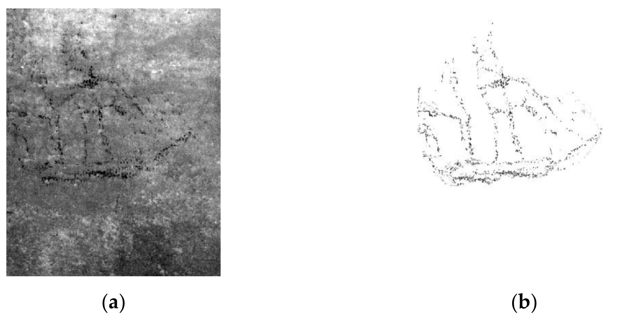
On the lower zone of the north-facing wall (Boreas wall, stone 322) a sketch made from black material [47], which looks like a large-sized sailing vessel (0.85 m × 0.54 m) moving towards the west (vessel 2), is depicted (Figure 6).
It is a two-masted ship with square rigging. The hull bears zig-zag lines; the stern, the bow and the rudder are well shaped; the square sails are well shaped; and the ropes on either side of the foremast and the mainmast are well depicted. Moving upwards on each mast, the size of the sails becomes smaller and smaller. On the lower mainmast, a four-cornered, gaff-rigged sail for improving the manoeuvrability of the ship is remarkably depicted. Moreover, a thin, carved, non-painted line extending beyond the bow represents the bowsprit, whereas the outline of the head sails is not clearly depicted. Therefore, the ship is a full-rigged brig with two square-rigged masts. These types of brigs that carry typical forms of rigging with Western European influences [47] were sailing in the Mediterranean sea during the 19th century and were also involved in the Greek sea battles during the War of Greek Independence [59]. One of the most distinguished Greek ships of the Greek War of Independence was the brig Ares (Ares was the god of war in Greek mythology). Thus, the digital tracing reproduction of the graffiti revealed a much clearer depiction of this graffiti regarding the rigging of the vessel.
4.2.2. Graffiti on the Zephyros (W) Wall (Stones 326, 355 and 356)
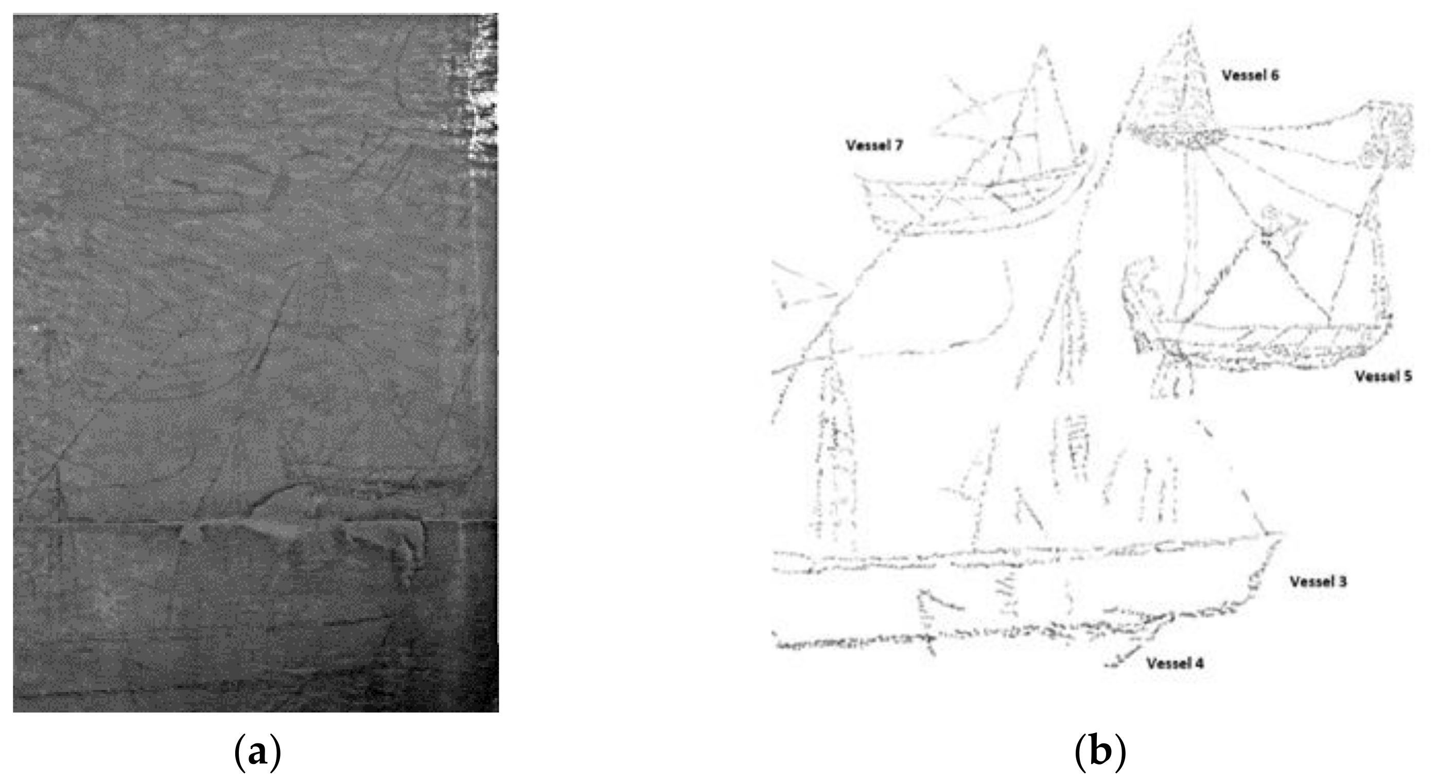
On the lower zone of the west-facing wall (Zephyros wall, stones 326, 355 and 356) seven pieces of ship graffiti (vessels 3–9) made with a black substance are recorded (Figure 7, Figure 8 and Figure 9). It must be noted that Damianidis in his sketches did not fully record vessel 6, and he did not detect vessels 4 and 7 at all [47].
Vessel 3 is a medium-sized sketch (0.49 m × 0.42 m). It depicts a sailing vessel appearing to move towards the south (Figure 7). It has a well-depicted oblong hull with a grid of lines rising above it. The vertical lines represent the three masts of the vessel; the mainmast is the tallest. The masts are crossed by lines running in the bow–stern direction, which represent the long yards. On both sides of each mast, two lines starting from the top of the mast and ending above the deck represent the ropes of the masts. This type of vessel with triangular sails set on long yards mounted at an angle on the masts, known as lateen sails, was sailing in the Mediterranean sea as well as during the 18th, 19th and 20th centuries [47,60]. Vessel 3’s graffiti presents a 18th- or 19th-century sailing vessel with lateen sails, which is already mentioned in the literature [47]. However, our work revealed one more lateen sail mounted on the mizzenmast of vessel 3, the ropes on both sides of the mizzenmast and a more clear and accurate depiction of the whole work of graffiti. Moreover, below the mainmast of vessel 3, another small-sized (0.22 m × 0.19 m) sailing vessel (vessel 4) is recorded. It is a one-mast vessel with a triangular sail. It seems to be sailing in a rough sea towards the north.
Vessel 5 is a medium-sized sketch (0.31 m × 0.28 m). It depicts a sailing vessel appearing to move towards the north (Figure 7). The outline of its hull is discernible and is painted in detail. The deck is designed with parallel lines, adding a sense of depth to the graffiti, whereas the hull is painted with a pattern of wavy lines, which could also refer to the sea waves. The inclined, straight line above the bow represents the mast and a well-designed square sail is set on its top. The diagonal line starting from the bow and going towards the stern represents a diagonal yard which is used to hold the sole sail of the vessel open. In the middle of the diagonal yard, a square flag is apparent, bearing a saltire. The outlines of the single sail and the ropes are depicted with thin lines. When focusing on the bow, the bowsprit is notably absent. However, the lines above the bow seem to be part of the outline of triangular sails (e.g., outer and inner jib) which is enhanced by the fact that they converge beyond the bow. This rigging is typical of 18th- and 19th-century vessels known as sacoleva, which sailed in the Aegean Sea and the Black Sea [47]. The digital tracing reproduction of the graffiti of vessel 5 produced a clear depiction of the sole sail outline and its ropes, supporting the theory that vessel 5 is a sacoleva of the 18th and 19th centuries.
Vessel 6 is a very small-sized piece of charcoal graffiti (0.13 m × 0.05 cm) (Figure 7). It depicts a one-masted vessel with an elongated hull and two triangular sails painted with a dashed line pattern. Although a rough sketch for vessel 6 has already been mentioned in the literature [47], our work recorded a much clearer depiction of its rigging.
Vessel 7 is a small-sized piece of charcoal graffiti (0.18 m × 0.18 m) recorded for the first time (Figure 7). Although its large hull and its deck are well designed, its rigging is not clearly depicted. However, it is quite likely to be a sacoleva. The inclined, straight line above the bow represents the mast, whereas the roughly sketched diagonal line starting from the bow and going towards the stern could represent a diagonal yard. The other lines recorded represent ropes.
Vessel 8 is a small-sized piece of charcoal graffiti (0.22 m × 0.14 m). It depicts a small two-masted square-rigged vessel with a bowsprit, which appears to move towards the south (Figure 8). The oblong hull, the stern and the bow as well are well shaped. The ropes on either side of the foremast and the three square sails are remarkably depicted. Although the sails of the mainmast are not clearly depicted, a gaff-rigged sail is obvious. The line extending beyond the bow represents the bowsprit. The lines extending below the bow could be attributed to a part of the rigging of a sailing boat (bobstay), which counteracts the upward tension on the bowsprit from the jibs and forestay. Our work provides more evidence concerning the rigging of the vessel. So, the vessel has all the typical characteristics of brigs from the first half of the 19th century [47], whose shipbuilding continued in Greece until the end of the 19th century [59,61].
Vessel 9 is a small-sized piece of charcoal graffiti (0.21 m × 0.14 m). It depicts a two-masted vessel with square rigging which appears to move towards the north (Figure 9). Moving upwards on each mast, the size of the sails becomes smaller and smaller, whereas a four-cornered sail on the lower main mast is slightly discernible. Moreover, the outline of the hull, the outline of the square sails, the bowsprit and its triangular sail (head sail) are depicted. The digital tracing reproduction of the graffiti revealed a slightly clearer depiction of the rigging of the vessel, suggesting that vessel 9 is a depiction of a brig from the first half of the 19th century [47].
4.2.3. Graffiti on Notos (S) Wall (Stones 330 & 342)
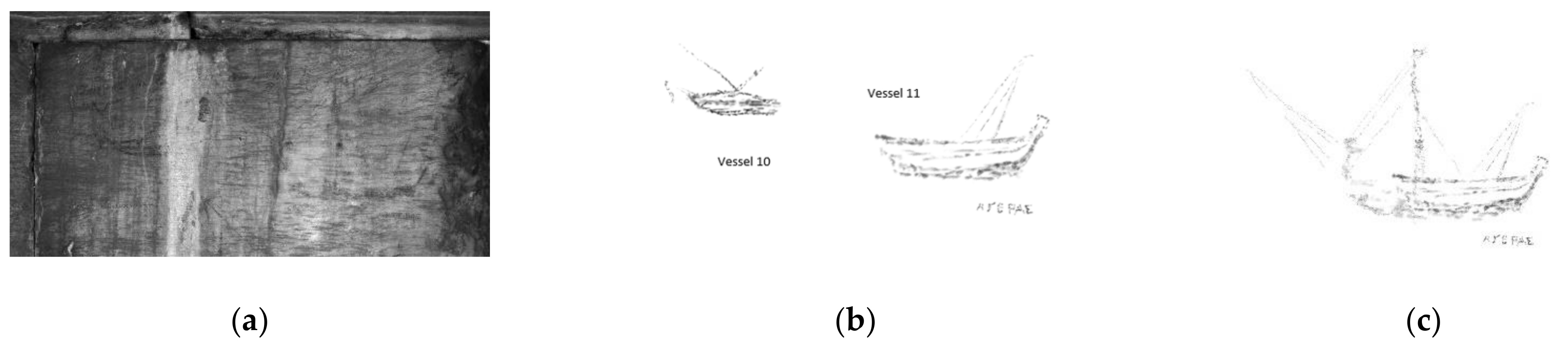
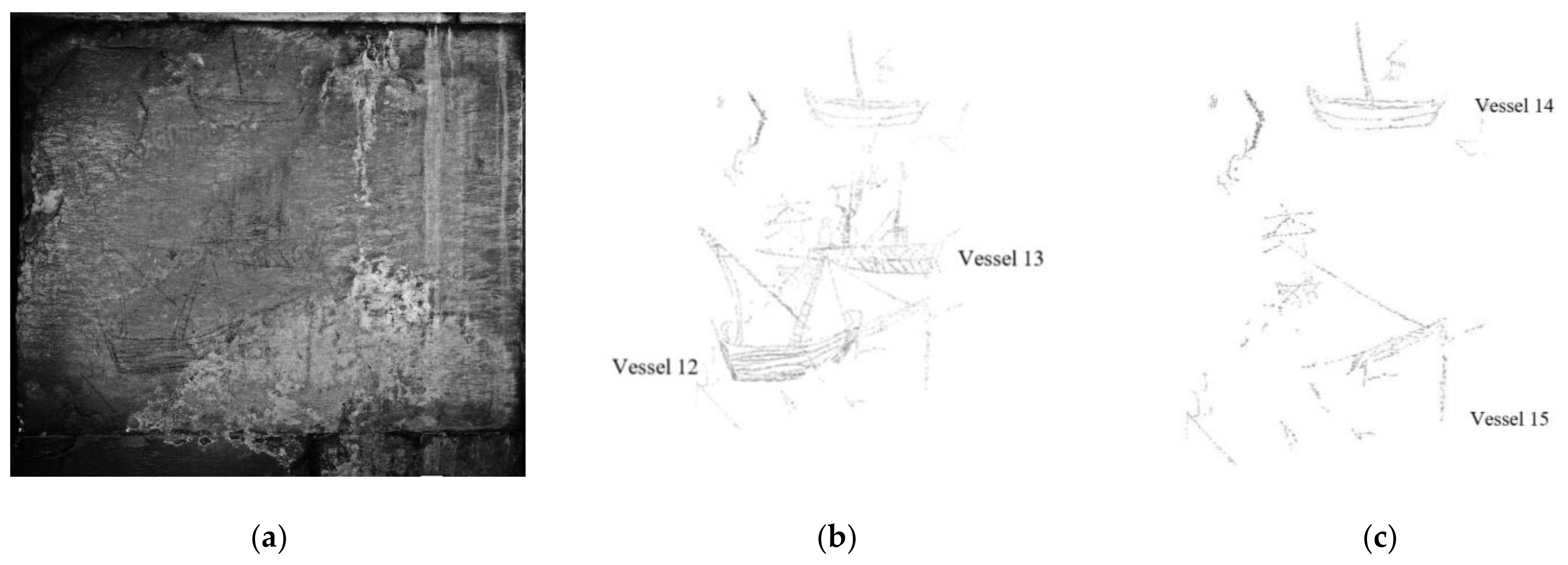
On the lower zone of the south-facing wall (Notos wall, stones 330 and 342), six charcoal graffiti are painted (Figure 10 and Figure 11). On stone 342, a small-sized piece of graffiti (vessel 10) and a larger one (vessel 11) are recorded (Figure 10), whereas on stone 330 three large-sized pieces of graffiti (vessel 12–14) and a small one (vessel 15) are recorded (Figure 11).
Vessel 10 is a small-sized sketch (0.15 m × 0.11 m). It depicts a one-masted vessel with a sole sail which appears to move towards the west (Figure 10). The outlines of the hull, the deck and the raised stern are well depicted. The bow is not clearly depicted, whereas the bowsprit is notably absent. Above the deck, the inclined straight line towards the bow represents the mast, whereas the diagonal line starting from the bow and going towards the stern represents the diagonal yard, which is used to hold the sole sail of the vessel open. Despite the intense alterations on the stone’s surface, the digital tracing reproduction of the graffiti resulted in a clearer depiction of the outline of the sketch. Thus, the rigging denotes that vessel 10 is a sacoleva from the 18th and 19th centuries [47,59].
Vessel 11 is a medium-sized sketch. It depicts a vessel with no mast or rigging, which appears to move towards the east (Figure 10). The hull, the stern and the bow are well depicted (Figure 10b). The lower part of the hull is painted with a continuous line pattern, giving either a sense of colour or a sense of the sea’s surface, whereas the drawing lines above the hull provide no adequate indications to form conclusions about the rigging. However, further image processing revealed additional surrounding drawings, and the rigging appearing above the hull of vessel 11 seems to depict the rigging of a one-masted vessel (Figure 10c). Additional information is produced, compared to the findings of Damianidis’ study [47]. Furthermore, an inscription is written below the stern of vessel 11. The word ‘AΓΕΡAΣ’, the Greek word for ‘WIND’, is evidence highly related to the use of the monument.
Vessel 12 is a medium-sized sketch (0.51 m × 0.35 m). It depicts a one-masted vessel with a sole sail, which appears to move towards the west (Figure 11). The outline of its hull is discernible and is painted with a continuous pattern of parallel lines. Additionally, the double lines on the stern and the painted bow add a sense of depth to the graffiti. Two almost-parallel, inclined, straight lines going towards the bow and painted with a line pattern represent the mast. The diagonal line starting from the bow and going towards the stern represents a diagonal yard, which is used to hold the sole sail of the vessel open. The clear depiction of vessel 12 provides further information for the documentation of the vessel as an 18th–19th century sacoleva [47,59].
This is the first time that vessels 13–15 have been recorded (Figure 11). Vessel 13 is a medium-sized (0.43 m × 0.27 m) sketch. It depicts a two-masted ship, which appears to move towards the east. The hull, painted with a herringbone pattern, has an overall length of 0.35 m with a discernible outline. However, the bow is not clearly depicted. On the top of the foremast, a square sail has been recorded, whereas the lines on either side of the masts represent the ropes. Thus, vessel 13 is a two-masted vessel with square rigging and could be characterised as a brig [59]. Vessel 14 is a medium-sized sketch (0.32 m × 0.24 m). It depicts a one-masted ship with no rigging, which appears to move towards the west. The outline of its hull is discernible and is painted with a continuous line pattern. Due to the inclined line towards the stern which represents the mast, it is likely the graffiti of vessel 14 was a rough drawing of a 18th–19th century sacoleva [59]. Finally, the most impressive piece of evidence from Stone 330 is a large-sized piece of graffiti from vessel 15 (Figure 11). The shape of the vessel, the outline of the hull and its rigging are different compared to those of other vessels discussed in this paper. However, it is fruitful evidence for further research on the documentation of vessel 15.
4.2.4. Graffiti on Lips (SW) Wall (Stones 328 and 329)
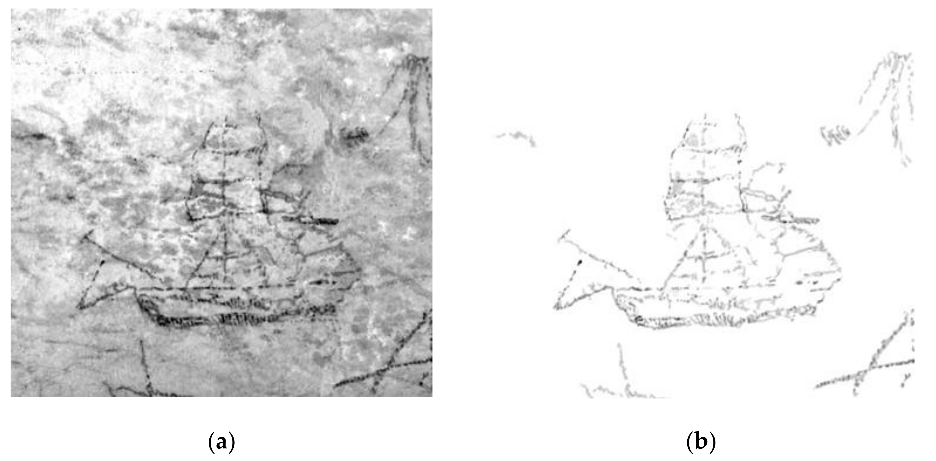
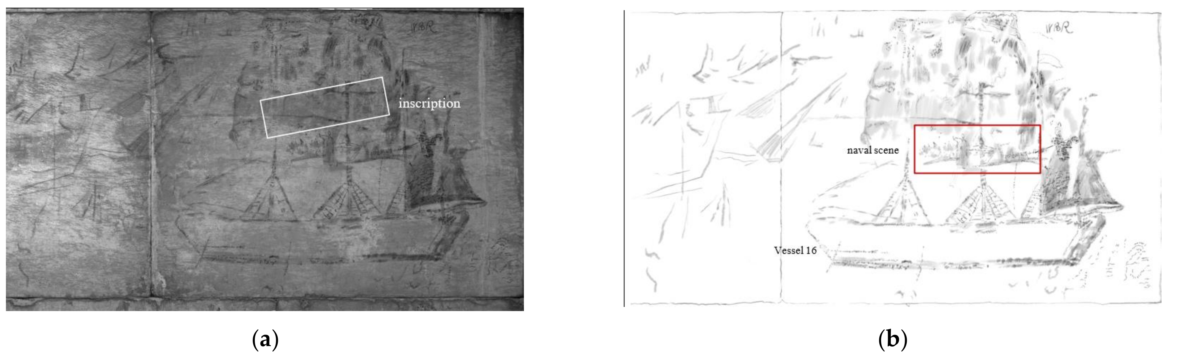
On the lower zone of the southwest-facing wall (Lips wall, stones 328 and 329) a large-sized ship graffiti (vessel 16) and a small-sized sketch of a naval scene, consisting of vessels and a silhouette of a man, are painted (Figure 12).
Vessel 16 is a large-sized sketch (1.65 m × 1.10 m). It depicts a three-masted ship (foremast, mainmast, mizzenmast) with square-rigged sails and a gaff-rigged sail, which appears to move towards the south (Figure 12). It has a distinct oblong hull and the double bold lines on its deck add a sense of depth to the sketch. The stern is depicted in detail with a pattern of parallel lines which also adds to the sense of depth. In the front part of the hull, two lines at an angle to the hull are drawn. They could represent oars. Three lines rising above the deck represent three masts. The grid of lines on either side of the masts represents the ropes. The mainmast has the most ropes, with the mizzenmast and the foremast following. The ropes of the mainmast are intensively depicted, whereas the ropes of the mizzenmast are partially hidden by the well-painted mizzenmast sail. The outline of the sails is not clearly depicted. When looking at the graffiti from a distance, three square sails on the foremast, three square sails on the mainmast and two sails on the mizzenmast can be seen. Moreover, when moving upwards on each mast, the size of the sails becomes smaller and smaller. As it can be observed, the middle mast sketch continues onto stone 306, where a flag with a saltire can be seen. On the top of the mizzenmast, a waving flag is clearly depicted. Above this flag the letters ‘WBR’ can be seen. The sails on the foremast and the mainmast are symmetrically painted on them whereas a four-cornered sail above the stern is remarkably depicted. Although the ship has no bowsprit, three triangular oblong sails (jibs) are depicted. Thus, our work recorded a much clearer depiction of the ship graffiti providing more evidence concerning the documentation of vessel 16 as a barque, a type of sailing vessel from the recent past (18th–19th century) [47]. Such vessels were known to sail in the Aegean Sea, following the Treaty of Kuchuk–Kainarji (21 July 1774) signed between the Russian Empire and the Ottoman Empire [59]. The dating of the ship between the 17th century and the middle of the 18th century is enhanced by the existence of the oars, as the oars were characteristic of the pirate warships of that period. Moreover, it is recorded in the literature that the Christian pirates usually caused problems to the Ottomans [62].
A special feature of the graffiti of vessel 16 is the large, empty space below the lower part of the sails. Focusing on the mainmast’s detailed representations, drawings and depictions are about to reveal. A small-sized graffiti exactly behind the mainmast has been recorded. It depicts a sailing vessel (vessel 17) with no clear rigging. The outline of the hull is obvious, whereas the lines above the deck could represent ropes or the outline of a sail. This piece of evidence shows that vessel 17 depicts a roughly designed one-masted ship. Next to it, the silhouette of a man wearing a himation over a chiton is recorded. Below the raised right hand of the silhouette, graffiti of three vessels has been recorded. Moreover, next to vessel 17, another vessel is recorded. Thus, a naval battle scene consisting of four vessels and a figure has been recorded.
In addition, above the figure (Figure 12), the carved inscription ‘H Σ A A’ has been recorded. The last letter ‘A’ of the inscription is smaller in size than the other letters.
4.3. Symbolism of Ships
The present documentation revealed new and important evidence concerning the use of the monument throughout the centuries. The current vessel depictions are more detailed than Damianidis’ ones. Interesting evidence, such as the eye ornament on the bow of the ancient ship graffiti on the Evros wall, the new vessel graffiti on the Zephyros wall, the inscription ‘AΓΕΡAΣ’ on the Notos wall, and the navy battle painting and the human silhouette on the Lips wall, show that the monument is highly related to the symbolism of ships and religious affairs.
In antiquity, ships were an integral part of the daily activities of the civilizations that flourished around the Mediterranean sea. For instance, warships with oars have been depicted on ancient Greek vases as decorative elements since the 8th century B.C. [63,64]. In ancient Greece and Rome, the worship of sea deities, maritime votive offerings and naval dedications were very common [65]. The most powerful sea deity was the god of the sea, Poseidon, who was also the protector of seafarers and of many Hellenic cities and colonies. Another sea deity of Greek and Roman mythology was Triton, the son of Poseidon, whose figure was fixed at the top of the roof of the Horologion of Andronikos as a bronze weathervane [8]. Ships also played a crucial role in religious affairs. The ship was an ancient Christian symbol. In Christianity, the lamb or the fish represents Christ, whereas the ship represents the Christian church. The cross is the symbol which defeats death and therefore the cross on the top of the mast of the ship protects the ship from dangers at sea.
The graffiti on the Horologion of Andronikos (Table 2) may be votive offerings to the Gods. The ancient ship graffiti (vessel 1a and 1b) may be a votive offering to Aeolus or/and Triton, whereas the graffiti from the recent past may be either a votive offering to Christian saints of sailors and merchants with regard to safety at sea or winning navy battles. This is also enhanced by the fact that some pieces of graffiti bear flags with a cross and by the navy battle painting depicted on the Lips wall. Our suggestions are in accordance with the literature. For example, on the exterior walls of Haghia Sophia in Trabzon [66], there are ship carvings made by sailors to ask for God’s help while sailing.
Ship graffiti is also related to events that happened on the coast [62], to life experiences or to very personal expressions of the sketchers [24]. It is quite likely graffiti representation was created only for simple amusement [62], and the painters could be shepherds, goatherds, visitors or people having the detailed knowledge of the structure of warships, cargo and boats [67].
5. Conclusions
The systematic and comprehensive way that the internal wall surfaces of the Horologion of Andronikos Kyrristos or the Tower of the Winds were studied, using modern non-destructive spectral imaging techniques, brought forth new evidence for the historical life of the monument through the centuries. The present study focuses on the lower stones of the internal north-, west-, south- and southwest-facing walls of the building. The most fruitful evidence, which comes from visible and near-infrared light (infrared images at 800 nm), revealed 17 vessels and a naval scene. Among them, two ancient vessels of the Late Roman period (2nd–early 4th century) are depicted, whereas the rest of them are modern vessels of the recent past (17th–19th century). Our knowledge concerning the history of the monument is greatly enriched by revealing the graffiti in a more detailed and thoroughly documented way; it could be explained as votive offerings to ancient Gods, Aeolus or/and Triton or votive offering to Christian saints of sailors and merchants with regard to safety at sea or winning navy battles, which is in accordance with the historical use of the monument.
Author Contributions
Conceptualization, E.P. and A.G.A.; methodology, A.G.A., A.A.K. and G.T.; validation, A.G.A. and E.P.; investigation, E.P.; resources, E.P., A.G.A., A.A.K.; data curation, G.T., writing—original draft preparation, E.P. and A.A.K.; writing—review and editing, A.G.A.; visualization, E.P. and G.T.; supervision, A.G.A.; project administration, A.G.A. All authors have read and agreed to the published version of the manuscript.
Funding
Project: ‘Conservation and Valorization of the Horologion of Andronikos Kyrristos at the archaeological site of the Roman Agora of Athens’ of the National Strategic Reference Framework 2007–2013 was funded initially by the A’ Ephorate of Prehistoric and Classical Antiquities, followed by the Ephorate of Antiquities of Athens, Ministry of Culture and Sports and ARTICON Lab: Conservation Promotion of Visual Arts, Books and Archival Material of the Faculty of Applied Arts and Culture, University of West Attica, Greece.
Institutional Review Board Statement
Not applicable.
Informed Consent Statement
Not applicable.
Data Availability Statement
Publicly available datasets were analysed in this study. This data can be found here: http://odysseus.culture.gr/h/2/eh251.jsp?obj_id=1839 (accessed on 24 August 2022).
Acknowledgments
The authors would like to thank the employees of the A’ Ephorate of Prehistoric and Classical Antiquities (now Ephorate of Antiquities of Athens) for their support and cooperation during the in situ study and analyses, as well as the reviewers for their comments. Funding acquisition, A’ Ephorate of Prehistoric and Classical Antiquities of Athens, ARTICON Lab UniWA.
Conflicts of Interest
The authors declare no conflict of interest.
References
- Kienast, J.H. The Tower of the Winds in Athens: Hellenistic or Roman? In Proceedings of the Romanization of Athens; Hoff, M.C., Rotroff, S.I., Eds.; Oxbow Books: Lincoln, OR, USA, 1997; pp. 53–65. [Google Scholar]
- Wycherley, R.E. The Stones of Athens; Princeton University Press: Princeton, NJ, USA, 1978. [Google Scholar]
- Ministry of Culture and Sports-Ephorate of Antiquities of Athens, Athens, Greece. Available online: https://efaathculture.gr/wp-content/uploads/2016/05/the-conservation-and-valorization-of-the-horologon-of-andronikos-of-kyrrhos.pdf (accessed on 23 August 2022).
- Delambre, Μ. L’ Histoire de L’Astronomie Ancienne; Mme Vve Courcier, Libraire Pour les Sciences: Paris, France, 1817. [Google Scholar]
- Kienast, H.J. The Tower of the Winds in Athens. AAIA Bull. 2013, 9, 20–29. [Google Scholar]
- Kienast, H.J. Der Turm der Winde in Athen; Archäologische Forschungen; Reichert Verlag: Wiesbaden, Germany, 2014; p. 30. [Google Scholar]
- Stuart, J.; Revett, N. The Antiquities of Athens; J. Haberkorn: London, UK, 1762. [Google Scholar]
- Varro, M.T. Rerum Rusticarum; Libri III; Teubner: Lipsia, Germany, 1929. [Google Scholar]
- Pollio, M.V. De Architecturei; Book I; Dover Publications: Mineola, NY, USA, 1960. [Google Scholar]
- Bechi, L. L’Anonimo Ambrosiano. Un Itinerario in Grecia di Urbano Bolzanio; ATTI della Academia Nazionale dei Lincei: Rome, Italy, 1984; Volume 1–2, pp. 3–22. [Google Scholar]
- Frantz, A. Late Antiquity: A.D. 267–700 (Athenian Agora); The American School of Classical Studies at Athens: Princeton, NJ, USA, 1988; Volume XXIV. [Google Scholar]
- Laskaris, N. Monuments Funeraires Paleochretiens (et Byzantins) de Grece; Vasilopoulos: Athens, Greece, 2000. [Google Scholar]
- Noble, N.J.; Solla Price, D.J. The Water Clock in the Tower of the Winds. Am. J. Archaeol. 1968, 72, 345–355. [Google Scholar] [CrossRef]
- Robinson, H. The Tower of Winds and the Roman Market-Place. Am. J. Archaeol. 1943, 47, 291–305. [Google Scholar] [CrossRef]
- Small, B. A Proposal for the reuse of the Tower of the Winds. Am. J. Archaeol. 1980, 84, 96–99. [Google Scholar] [CrossRef]
- Spetsieri-Choremi, A. Πολεοδομική εξέλιξη και μνημειώδη κτήρια στην Aθήνα κατά την εποχή του Aυγούστου και του Aδριανού [Urban development and monumental buildings in Athens of the times of Augustus and Hadrian]. In Aθήναι. Aπό την Κλασική εποχή έως Σήμερα (5ος αι. π.Χ.–2000 μ.Χ.) [Athens. From the Classical Era to the Present (5th Century B.C.–2000 A.D.)]; Bouras, C., Ed.; ΚOΤΙΝOΣ: Athens, Greece, 2000. [Google Scholar]
- Travlos, Ι. Πολεοδομική Εξέλιξις των Aθηνών [Urban Development of Athens]; ΚAΠOΝ: Athens, Greece, 2005. [Google Scholar]
- Tsoniotis, N.; Karamperidi, A. New Evidence for the Use of the Horologion of Andronikos Kyrrhistos during the Byzantine Period. In Proceedings of a Conference Byzantine Athens; Saradi, H., Ed.; Byzantine & Christian Museum Press: Athens, Greece, 2021; pp. 264-278, 397-403. [Google Scholar]
- Volanakis, I. Τα παλαιοχριστιανικά Βαπτιστήρια της Ελλάδος [The early Christian Baptisteries of Greece]; Archaeological Society at Athens: Athens, Greece, 1976. [Google Scholar]
- Papastamatiou, K.; Photopoulou, M. Ωρολόγιο του Aνδρόνικου Κυρρήστου. Μελέτη Συντήρησης. Τεύχος 1ο. Τεχνική Έκθεση [The Horologion of Andronikos Kyrristos. Conservation Study. Vol. 1. Technical Report]; General Directorate of Antiquities and Cultural Heritage, Directorate of Preservation of Ancient and Modern Monuments Ministry of Culture and Tourism: Athens, Greece, 2011.
- Almqvist, B.; Lindblad, T.B.; Nystrom, M.; Sjostrand, T. Graffiti Cookbook: A Guide to Techniques and Materials; Dokument Press: Warsaw, Poland, 2013. [Google Scholar]
- Ganz, N.; Manco, T. Graffiti World: Street Art from five Continents; Harry, N., Ed.; Abrams Inc. Publishers: New York, NY, USA, 2004. [Google Scholar]
- Scribbling though History: Graffiti, Places and People from Antiquity to Modernity; Ragazzoli, C.; Harmansah, O.; Salvador, C.; Frood, E. (Eds.) Bloomsbury Academic: London, UK, 2018. [Google Scholar]
- Demesticha, S.; Delouca, K.; Trentin, M.G.; Bakirtzis, N.; Neophytou, A. Seamen on Land? A Preliminary Analysis of Medieval Ship Graffiti on Cyprus. Int. J. Naut. Archaeol. 2017, 46, 346–381. [Google Scholar] [CrossRef]
- Keegan, P. Graffiti in Antiquity; Routledge: New York, NY, USA, 2014. [Google Scholar]
- Zerboni, A.; Villa, F.; Wu, Y.-L.; Solomon, T.; Trentini, A.; Rizzi, A.; Cappitelli, F.; Gallinaro, M. The Sustainability of Rock Art: Preservation and Research. Sustainability 2022, 14, 6305. [Google Scholar] [CrossRef]
- Bracci, S.; Sacchi, B. In situ Assessment of Conservation Treatments and Monitoring of Their Effectiveness. In Conserving Stone Heritage. Cultural Heritage Science; Gherardi, F., Maravelaki, P.N., Eds.; Springer: Cham, Switzerland, 2022; pp. 231–274. [Google Scholar] [CrossRef]
- Fischer, C.; Kakoulli, I. Multispectral and hyperspectral imaging technologies in conservation: Current research and potential applications. Rev. Conserv. 2006, 7, 3–16. [Google Scholar] [CrossRef]
- Liang, H. Advances in multispectral and hyperspectral imaging for archaeology and art conservation. Appl. Phys. A 2012, 106, 309–323. [Google Scholar] [CrossRef] [Green Version]
- Polak, A.; Kelman, T.; Murray, P.; Marshall, S.; Stothard, D.J.M.; Eastaugh, N.; Eastaugh, F. Use of infrared hyperspectral imaging as an aid for paint identification. J. Spectr. Imaging 2016, 5, a2. [Google Scholar] [CrossRef] [Green Version]
- Tonazzini, A.; Salerno, E.; Abdel-Salam, Z.A.; Harith, M.A.; Marras, L.; Botto, A.; Campanella, B.; Legnaioli, S.; Pagnotta, S.; Poggialini, F.; et al. Analytical and mathematical methods for revealing hidden details in ancient manuscripts and paintings: A review. J. Adv. Res. 2019, 17, 31–42. [Google Scholar] [CrossRef]
- Cosentino, A. Infrared technical photography for art examination. E-Preserv. Sci. 2016, 13, 1–6. [Google Scholar]
- Delaney, J.K.; Thoury, M.; Zeibel, J.G.; Ricciardi, P.; Morales, K.M.; Dooley, K.A. Visible and infrared imaging spectroscopy of paintings and improved reflectography. Herit. Sci. 2016, 4, 6. [Google Scholar] [CrossRef] [Green Version]
- Mastrotheodoros, G.P.; Theodosis, M.; Filippaki, E.; Beltsios, K. By the hand of Aggelos? Analytical investigation of a remarkable 15th century Cretan icon. Heritage 2020, 3, 1360–1372. [Google Scholar] [CrossRef]
- Pelagotti, A.; Del Mastio, A.; De Rosa, A.; Piva, A. Multispectral imaging of paintings. IEEE Signal Process. Mag. 2008, 25, 27–36. [Google Scholar] [CrossRef]
- Imai, K.; Delaney, J.K.; Webster-Cook, S.; Jimenez, R. Pablo Picasso’s Mother and Child by the Sea (1902): Report on the hyperspectral near-infrared reflectance imaging survey of Picasso’s newspaper use. SN Appl. Sci. 2020, 2, 1474. [Google Scholar] [CrossRef]
- Hollaus, F.; Diem, M.; Fiel, S.; Kleber, F.; Sablatnig, R. Investigation of Ancient Manuscripts based on multispectral imaging. In Proceedings of the DocEng ’15: ACM Symposium on Document Engineering 2015, Lausanne, Switzerland, 8–11 September 2015; Association for Computing Machinery: New York, NY, USA, 2015; pp. 93–96. [Google Scholar] [CrossRef]
- Alexopoulou, A.; Kaminari, A.; Panagopoulos, A.; Pöhlmann, E. Multispectral documentation and image processing analysis of the papyrus of tomb II at Daphne, Greece. J. Archaeol. Sci. 2013, 40, 1242–1249. [Google Scholar] [CrossRef]
- Liang, H.; Lucian, A.; Lang, R.; Cheung, C.S.; Su, B. Remote spectral imaging with simultaneous extraction of 3D topography for historical wall paintings. J. Photogramm. Remote Sens. 2014, 95, 13–22. [Google Scholar] [CrossRef] [Green Version]
- Cucci, C.; Picollo, M.; Chiarantini, L.; Uda, G.; Fiori, L.; De Nigris, B.; Osanna, M. Remote-sensing hyperspectral imaging for applications in archaeological areas: Non-invasive investigations on wall paintings and on mural inscriptions in the Pompeii site. Microchem. J. 2020, 158, 105082. [Google Scholar] [CrossRef]
- Kaimaris, D.; Kandylas, A. Small multispectral UAV sensor and its image fusion capability in cultural heritage applications. Heritage 2020, 3, 1046–1062. [Google Scholar] [CrossRef]
- Kogou, S.; Shahtahmassebi, G.; Lucian, A.; Liang, H.; Shui, B.; Zhang, W.; Su, B.; van Schaik, S. From remote sensing and machine learning to the history of the Silk Road: Large scale material identification on wall paintings. Sci. Rep. 2020, 10, 19312. [Google Scholar] [CrossRef]
- Legnaioli, S.; Lorenzetti, G.; Cavalcanti, G.H.; Grifoni, E.; Marras, L.; Tonazzini, A.; Salerno, E.; Pallecchi, P.; Giachi, G.; Palleschi, V. Recovery of archaeological wall paintings using novel multispectral imaging approaches. Herit. Sci. 2013, 1, 33. [Google Scholar] [CrossRef] [Green Version]
- Alexopoulou, A.; Kaminari, A.A.; Moutsatsou, A. Multispectral and Hyperspectral Studies on Greek Monuments, Archaeological Objects and Paintings on Different Substrates. Achievements and Limitations. In Transdisciplinary Multispectral Modeling and Cooperation for the Preservation of Cultural Heritage. Communications in Computer and Information Science; Moropoulou, A., Korres, M., Georgopoulos, A., Spyrakos, C., Mouzakis, C., Eds.; Springer: Berlin/Heidlberg, Germany, 2019; Volume 962, pp. 443–461. [Google Scholar] [CrossRef]
- Damianidis, K.A. Roman ship graffiti in the Tower of the Winds in Athens. Archaol. Korresp. 2011, 41, 85–99. [Google Scholar] [CrossRef]
- Damianidis, K.A.; Kienast, J.K. Ship Graffiti on the Walls of the Tower of the Winds. In Proceedings of the 8th International Symposium (Tropis VIII) on Ships Construction in Antiquity, Hydra, Greece, 27–30 August 2002. [Google Scholar]
- Damianidis, K.A. Study of ancient ship-graffiti from the Black Sea and the Aegean. In Seapower, Technology and Trade. Studies in Turkish Maritime History; Couto, D., Gunergun, F., Redani, M.P., Eds.; Piri Reis University Publications: Istanbul, Turkey, 2014; pp. 450–459. [Google Scholar]
- Morrison, J.S.; Coates, J.F.; Rankov’s, N.B. The Athenian Trireme; University Press: Cambridge, UK, 2000. [Google Scholar]
- Morrison, J.S.; Williams, R.T. Greek Oared Ships 900–322 B.C.; Cambridge University Press: Cambridge, UK, 1968. [Google Scholar]
- Morrison, J.S. Greek and Roman Oared Warships. 399–30 B.C.; Oxbow Books: Oxford, UK, 1996. [Google Scholar]
- Basch, L. Le Musée Imaginaire de la Marine Antique; Institut Hellénique pour la Préservation de la Tradition Nautique: Athens, Greece, 1987. [Google Scholar]
- Casson, L. Ships and Seamanship in the Ancient World; Johns Hopkins University Press: London, UK, 1995. [Google Scholar]
- Friedman, Z. The Phoenician Hippos Figurehead. Preserved Tradition and Types of Ship. In Proceedings of the Symposion ‘On Sea and Ocean: New Research in Phoenician Seafaring’, Marburg, Germany, 23–25 June 2011; Eigenverlag des Archäologischen Seminars der Philipps-Universität: Marburg, Germany, 2011; pp. 19–34. [Google Scholar]
- Wachsmann, S. The ships of the Sea Peoples. Int. J. Naut. Archaeol. 1981, 10, 187–220. [Google Scholar] [CrossRef]
- Carlson, D.N. Seeing the Sea: Ships’ Eyes in Classical Greece. Hesperia J. Am. Sch. Class. Stud. Athens 2009, 78, 347–365. [Google Scholar] [CrossRef]
- Nowak, T.J. Archaeological Evidence for Ship Eyes: An Analysis of Their Form and Function. Master’s Thesis, Texas A&M University, College Station, TX, USA, May 2006. [Google Scholar]
- Wachsmann, S. Seagoing Ships & Seamanship in the Bronze Age Levant; A&M University Press: College Station, TX, USA, 1998. [Google Scholar]
- Pomey, P. La Navigation Dans L’Antiquité; Edisud: Aix-en-Provence, France, 1997. [Google Scholar]
- Delis, A. From Lateen to Square Rig: The evolution of the Greek-owned merchant fleet and its ships in the eighteenth and nineteenth centuries. Mar. Mirror 2014, 100, 44–58. [Google Scholar] [CrossRef]
- Campbell, I.C. The Lateen Sail in World History. J. World Hist. 1995, 6, 1–23. [Google Scholar]
- Delis, A. Modern Greece’s first industry? The shipbuilding center of sailing merchant marine of Syros 1830–70. Eur. Rev. Econ. Hist. 2015, 19, 255–274. [Google Scholar] [CrossRef]
- Stamatatou, E. Two Graffiti of Sailing Vessels at Paliachora on Aigina. Annu. Br. Sch. Athens 1997, 92, 435–440. [Google Scholar] [CrossRef]
- Kirk, G.S. Ships on Geometric Vases. Annu. Br. Sch. Athens 1949, 44, 93–153. [Google Scholar] [CrossRef]
- Münds, R. Archaische Schiffsdarstellungen auf attischen Vasen. In Schiffe und ihr Kontext. Darstellungen, Modelle, Bestandteile—Von der Bronzezeit bis zum Ende des Byzantinischen Reiches; Frielinghaus, H., Schmidts, T., Tsamakda, V., Eds.; Internationales Kolloquium: Mainz, Germany, 2017; pp. 39–49. [Google Scholar]
- Streuding, J.H. Success at Sea: Maritime Votive Offerings and Naval Dedications in Antiquity. Master’s Thesis, Texas A&M University, College Station, TX, USA, August 2014. [Google Scholar]
- Köse, İ. Haghia Sophia in Trabzon. Codrul Cosm. 2012, XVIII, 169–180. [Google Scholar]
- Van De Moortel, A.; Langdon, M.K. Graffiti: Archaic Ships from Southern Attica. Int. J. Naut. Archaeol. 2017, 46, 382–405. [Google Scholar] [CrossRef]
Figure 1.
(a) Northern view of the Horologion of Andronikos Kyrristos; (b) Eastern view of the Horologion of Andronikos Kyrristos.
Figure 1.
(a) Northern view of the Horologion of Andronikos Kyrristos; (b) Eastern view of the Horologion of Andronikos Kyrristos.

Figure 2.
Development of the three lowest rows of the internal stones of the building. The stone numbers show the location of the recorded vessels (see also Table 1).
Figure 2.
Development of the three lowest rows of the internal stones of the building. The stone numbers show the location of the recorded vessels (see also Table 1).

Figure 3.
(a) Image in visible raking light of the bow of the small-sized oared vessel graffiti (vessel 1a) on the Evros (SE) wall (stone 344); (b) digital tracing reproduction of the graffiti showing the drawing of vessels 1a’s bow.
Figure 3.
(a) Image in visible raking light of the bow of the small-sized oared vessel graffiti (vessel 1a) on the Evros (SE) wall (stone 344); (b) digital tracing reproduction of the graffiti showing the drawing of vessels 1a’s bow.

Figure 4.
(a) Image in visible raking light of the stern of the large-sized oared vessel graffiti (vessel 1b) on the Evros (SE) wall (stone 344); (b) digital tracing reproduction of the graffiti showing the drawing of vessel 1b’s stern.
Figure 4.
(a) Image in visible raking light of the stern of the large-sized oared vessel graffiti (vessel 1b) on the Evros (SE) wall (stone 344); (b) digital tracing reproduction of the graffiti showing the drawing of vessel 1b’s stern.

Figure 5.
(a) Image in visible raking light of the bow of the large-sized oared vessel graffiti (vessel 1b) on the Evros (SE) wall (stone 344); (b) digital tracing reproduction of the graffiti showing the drawing of vessel 1b’s bow.
Figure 5.
(a) Image in visible raking light of the bow of the large-sized oared vessel graffiti (vessel 1b) on the Evros (SE) wall (stone 344); (b) digital tracing reproduction of the graffiti showing the drawing of vessel 1b’s bow.

Figure 6.
(a) Infrared image (800 nm) of a two-masted vessel graffiti (vessel 2) on Boreas (N) wall (stone 322); (b) digital tracing reproduction of the graffiti showing the drawing of vessel 2.
Figure 6.
(a) Infrared image (800 nm) of a two-masted vessel graffiti (vessel 2) on Boreas (N) wall (stone 322); (b) digital tracing reproduction of the graffiti showing the drawing of vessel 2.

Figure 7.
(a) Infrared image (800 nm) of five vessel graffiti (vessels 3–7) on Zephyros (W) wall (stones 326 and 355); (b) digital tracing reproduction of the graffiti showing the drawing of vessels 3–7.
Figure 7.
(a) Infrared image (800 nm) of five vessel graffiti (vessels 3–7) on Zephyros (W) wall (stones 326 and 355); (b) digital tracing reproduction of the graffiti showing the drawing of vessels 3–7.

Figure 8.
(a) Infrared image (800 nm) of a vessel graffiti (vessel 8) on Zephyros (W) wall (stone 326); (b) digital tracing reproduction of the graffiti showing the drawing of vessel 8.
Figure 8.
(a) Infrared image (800 nm) of a vessel graffiti (vessel 8) on Zephyros (W) wall (stone 326); (b) digital tracing reproduction of the graffiti showing the drawing of vessel 8.

Figure 9.
(a) Infrared image (800 nm) of a vessel graffiti (vessel 9) on Zephyros (W) wall (stone 356); (b) digital tracing reproduction of the graffiti showing the drawing of vessel 9.
Figure 9.
(a) Infrared image (800 nm) of a vessel graffiti (vessel 9) on Zephyros (W) wall (stone 356); (b) digital tracing reproduction of the graffiti showing the drawing of vessel 9.

Figure 10.
(a) Infrared image (800 nm) of graffiti of two vessels (vessels 10–11) on the Notos (S) wall (stone 342); (b) digital tracing reproduction of the graffiti showing the drawing of vessels 10–11; (c) further image processing which shows the drawing of vessel 11 and additional surrounding drawings.

Figure 11.
(a) Infrared image (800 nm) of graffiti of four vessels (vessels 12–15) on the Notos (S) wall (stone 330); (b) digital tracing reproduction of the graffiti showing the drawing of vessels 12–15; (c) image processing which shows the drawing of vessels 14–15.
Figure 11.
(a) Infrared image (800 nm) of graffiti of four vessels (vessels 12–15) on the Notos (S) wall (stone 330); (b) digital tracing reproduction of the graffiti showing the drawing of vessels 12–15; (c) image processing which shows the drawing of vessels 14–15.

Figure 12.
(a) Infrared image (800 nm) of graffiti of two vessels (vessels 16–17) and a navy battle scene on the Lips (SW) wall (stones 328 and 329); (b) digital tracing reproduction of the graffiti showing the drawing of the naval scene and of vessels 16–17.
Figure 12.
(a) Infrared image (800 nm) of graffiti of two vessels (vessels 16–17) and a navy battle scene on the Lips (SW) wall (stones 328 and 329); (b) digital tracing reproduction of the graffiti showing the drawing of the naval scene and of vessels 16–17.


Table 1.
Summary table of the recorded vessels’ graffiti.
| Orientation of the Wall/Wind Deity of the Outer Wall | Figure | Stone Number | Dimension of Stone | Number of the Sketch of Vessel |
|---|---|---|---|---|
| SE/Evros | 3–5 | 344 | 173 cm × 108 cm | 1a, 1b |
| N/Boreas | 6 | 322 | 153 cm × 108 cm | 2 |
| W/Zephyros | 7–9 | 326 | 114.5 cm × 108 cm | 3–8 |
| 355 | - | 3 | ||
| 356 | - | 9 | ||
| S/Notos | 10–11 | 342 | 58–94 cm × 108 cm | 10, 11 |
| 330 | 132 cm × 108 cm | 12–15 | ||
| SW/Lips | 12 | 328 | 146 cm × 108 cm | 16 & naval scene |
| 329 | 141 cm × 108 cm | 16 | ||
| 306 | 204 cm × 30 cm | 16 |
Table 2.
Summary table of the type of graffiti on the Horologion of Andronikos.
| Number of the Sketch of Vessel | Dimension of the Sketch of Vessel | Type of Graffiti (Drawn or Engraved) |
|---|---|---|
| 1a | 1.26 m × 0.45 m | Oared ships/warships of Greek and Roman antiquity |
| 1b | 0.37 m × 0.18 m | warships of Greek and Roman antiquity |
| 2 | 0.85 m × 0.54 cm | brig |
| 3 | 0.49 m × 0.42 m | Three-masted vessel with lateen sails |
| 4 | 0.22 m × 0.19 m | one-masted sailing vessel |
| 5 | 0.31 m × 0.28 m | sacoleva |
| 6 | 0.13 m × 0.05 m | one-masted sailing vessel |
| 7 | 0.18 m × 0.18 m | no clear rigging (could be sacoleva) |
| 8 | 0.22 m × 0.14 m | brig |
| 9 | 0.21 m × 0.14 m | brig |
| 10 | 0.15 m × 0.11 m | sacoleva |
| 11 | - | no clear rigging |
| 12 | 0.51 m × 0.35 m | sacoleva |
| 13 | 0.43 m × 0.27 m | two-masted sailing vessel (could be brig) |
| 14 | 0.32 m × 0.24 m | one-masted sailing vessel (could be sacoleva) |
| 15 | - | - |
| 16 | 1.65 m × 1.10 m | barque |
| 17 | - | one-masted sailing vessel |
Publisher’s Note: MDPI stays neutral with regard to jurisdictional claims in published maps and institutional affiliations. |
© 2022 by the authors. Licensee MDPI, Basel, Switzerland. This article is an open access article distributed under the terms and conditions of the Creative Commons Attribution (CC BY) license (https://creativecommons.org/licenses/by/4.0/).
Share and Cite
MDPI and ACS Style
Panou, E.; Kaminari, A.A.; Tsairis, G.; Alexopoulou, A.G. Ship Graffiti in Horologion of Andronikos Kyrristos, Greece: A Comparative Study and New Evidence. Sustainability 2022, 14, 13791. https://doi.org/10.3390/su142113791
AMA Style
Panou E, Kaminari AA, Tsairis G, Alexopoulou AG. Ship Graffiti in Horologion of Andronikos Kyrristos, Greece: A Comparative Study and New Evidence. Sustainability. 2022; 14(21):13791. https://doi.org/10.3390/su142113791
Chicago/Turabian StylePanou, Evangelia, Agathi Anthoula Kaminari, Georgios Tsairis, and Athina Georgia Alexopoulou. 2022. "Ship Graffiti in Horologion of Andronikos Kyrristos, Greece: A Comparative Study and New Evidence" Sustainability 14, no. 21: 13791. https://doi.org/10.3390/su142113791
Note that from the first issue of 2016, this journal uses article numbers instead of page numbers. See further details here.