Article

Root Water Uptake Patterns for Nitraria during the Growth Period Differing in Time Interval from a Precipitation Event in Arid Regions

1
The Institute of Hydrogeology and Environmental Geology, Chinese Academy of Geological Sciences, Shijiazhuang 050061, China
2
Key Laboratory of Groundwater Sciences and Engineering, Ministry of Natural Resources, Shijiazhuang 050061, China
*
Authors to whom correspondence should be addressed.
Sustainability 2022, 14(13), 8203; https://doi.org/10.3390/su14138203
Submission received: 3 May 2022 / Revised: 31 May 2022 / Accepted: 28 June 2022 / Published: 5 July 2022
(This article belongs to the Special Issue Application of Isotope Techniques on Water Resources Management)

Abstract

:
Vegetation root water uptake is one of the most central water transport processes along the soil-vegetation-atmosphere interface particularly in (semi-)arid ecosystems. The identification and quantification of root activities and water uptake patterns of arid vegetation remain challenging. This paper aims at the quantitative examination of water uptake behaviors of Nitraria, a prevalent desert species in arid environments, during the growth phase via a multivariate linear mixed model based on water stable isotopes, with a main focus on the time interval from a precipitation pulse. The observations indicate that the precipitation events exert periodic significant pulse-effects on vegetation water uptake through direct absorption (contribution of almost 75%) and activation of deep root activity at a certain depth. While in most occasions without rainfall, Nitraria relies on its extremely extensive shallow roots in surface-near lateral zone (contribution of about 60%) to extract massive soil as well as the hydraulic lifting mechanism to survive drought. Achievements would be beneficial to enhancing the understanding of entangled water transport processes and eco-hydrological feedbacks along soil-vegetation interface in arid ecosystems and contribute to a scientific allocation to water resources with the consideration of ecological protection.

1. Introduction

Vegetation root water uptake has been recognized to play a major role in the entangled water transport processes and eco-hydrological feedbacks along the soil-vegetation-atmosphere interface particularly in arid ecosystems worldwide [1,2,3]. Meanwhile, various arid species, usually with high ecological plasticity, would develop variable roots system structures and water uptake patterns especially related to the water availabilities in order to survive the long-term or short-term drought [4,5,6]. Hence, the quantitative investigation of root activities and relative uptakes to different contributors remain one of a great challenges in the field of plant ecological hydrology globally [7,8,9,10].
Water stable isotopes-based approaches have been reported to provide a unique opportunity to trace the eco-hydrological processes along soil-vegetation interface that have been difficult to deal with previously [10]. Many scholars around the world [11,12,13,14] have examine the vertical water uptake patterns of arid vegetation with different function types via water isotopic methods.
Antunes et al. [15] established the seasonal water uptake proportion by different plants in Mediterranean coastal dune systems differing in aridity in Europe by means of water isotope. Beyer et al. [7] obtained various source water contributions to different kinds of tree and shrub species utilizing the isotopic data of vegetation and potential contributors in the Elundu Forest Site in southern Africa. In inland arid regions of Northwest China, Jiang et al. [16] quantitatively analyzed the water use strategy of Nitraria shrub in the growing season of Qingtu Lake in the lower reaches of Shiyang River by the isotopic signatures of different sources of water, indicating that Nitraria gradually uses deep soil water and groundwater with the increase of distance from the lake. Li et al. [17] investigated the roots water use pattern and its temporal and spatial changes of Populus euphratica and Tamarix ramosissima in the riparian zone of Ejina Delta in the lower reaches of Heihe River based on natural 18O stable isotope, revealing their responses to groundwater level fluctuation and the hydraulic lift effect.
Many literature have documented that unpredictable precipitation pulses significantly alter the most common water uptake behaviors of arid vegetation [18,19,20], yet there are rare researches specifical in this regard by reviewing the latest relevant researches globally.
Thus, using the water stable isotope-based multivariate linear mixed model, the current research is aimed at the quantitative investigation for root water uptake patterns of Nitraria, a prevalent desert shrub species in arid environments of Northwest China with an important windbreak and sand fixation function, differing in time interval from a common precipitation event in arid regions.
The outcomes are helpful to get more insight into the water uptake strategies of Nitraria and other desert species, especially accounting for the short-term effects of precipitation pulses, and thus are beneficial for an elevated understanding of the entangled eco-hydrological processes along soil-vegetation interface in arid ecosystems. They also contribute to the sustainable management and maintenance for desert ecology.

2. Materials and Methods

2.1. Study Area

Qingtu Lake is the tail-end lake of an inland river, the Shiyang River, in Northwest China. The lake is affiliated with Minqin County, Wuwei city, Gansu Province, its geographical coordinates are 39.04 to 39.09° N and 103.36 to 103.39° E, and its altitude is 1292–1310 m. Located on the northern edge of Minqin Oasis, Qingtu Lake belongs to the oasis-desert transition zone, with the Badain Jaran Desert and Tengger Desert closely located in the northwest and southeast, respectively (Figure 1). Qingtu Lake is situated at the monsoon fringe, with a temperate continental arid desert climate. The annual average temperature is 7.8 °C, and the effective accumulated temperature of > 10 °C is as high as 3289.1 °C·d. The average annual precipitation is 89.8 mm, and the precipitation from July to September accounts for 73% of the precipitation of the whole year. The potential evaporation capacity is up to 2640 mm, which is approximately 24 times the amount of precipitation. The annual illumination is 3181 h, and northwesterly winds prevail throughout the year.
The research object Nitraria is known as a typical desert shrub species with a strong windbreak and sand fixing function.

2.2. Collection and Determination of Samples

There was a precipitation on 12 August 2019 and 6 replicates of the rainfall taken at different points were collected at the same day. Then, the samples were put into 8-mL borosilicate glass bottles, sealed with parafilm and refrigerated at 2 °C.
12 plots of 2 m × 2 m inside 4 (3 for each) typical desert plant communities dominated by Nitraria which were prevalent in the Qingtu Lake area were selected for study. The location and environment of each plot were ensured to be consistent and representative, including soil condition, micro-geomorphology.
Hydrogen and oxygen isotope sampling of Nitraria xylem water and the soil water of various soil layers at four different spots were implemented at different time intervals from the drizzle event respectively. The specific sampling dates were 13 August at S3 (1 day later), 17 August at S2 and S4 (5 days later) and 22 August at S1 (10 days later) (Figure 1).
For the hydrogen and oxygen isotope sampling of xylem water of Nitraria, three healthy individuals with similar condition were randomly selected as a sample (2 replicates) from each plot. Three corked stems from growth branch of each individual were collected, cut into 5-cm-long pieces, and the epidermis and phloem were quickly peeled off. Then, the samples were placed in an 8-mL borosilicate glass bottle, sealed with parafilm, and frozen at −10 °C.
For the simultaneous isotopic sampling for the soil moisture of different soil layers, on the inner wall of the excavated test pit, appropriate amounts of soil samples (full bottle of dry soil, 2/3-full bottle of wet soil, ½-full bottle of saturated clay) were collected vertically in 4 layers (0–10 cm, 10–30 cm, 30–50 cm and 50–70 cm). 3 duplicates were taken for each sample. Then, the samples were placed in 8-mL borosilicate glass bottles, sealed with parafilm and frozen at −10 °C.
Water in plant and soil samples was extracted using a cryogenic vacuum distillation system (LI-2100, LICA, Beijing, China). The extraction process required 1.5 to 3 h depending on the water content of the samples and the extraction efficiency was over 98%. Rain and extracted water were filtered using 0.22-μm organic phase pin-type filters. Isotopic measurements of all kinds of water were conducted using a Liquid-Water Isotope Analyzer (GLA431-TLWIA, ABB, Montreal, Quebec, Canada). The measurement precisions were ±0.4‰ for δ2H and ±0.1‰ for δ18O. According to the international standardized method, all data are thousand differences of the Vienna Standard Mean Ocean Water (VSMOW).

2.3. Multivariate Linear Mixed Model Method

The multivariate linear mixed model method was proposed by Phillips and Gregg [21] based on the principle of conservation of isotopic mass to determine the absorption ratio of plants to each potential water source. Its basic principle is that the hydrogen/oxygen isotope ratio of plant stem water is equal to the sum of the hydrogen/oxygen isotope ratio of each potential water source multiplied by its share (assuming that no hydrogen/oxygen isotope fractionation occurs during the process of plant roots absorbing water from the soil and transporting it to the xylem [22]:
δ X p = i = 1 n f i δ X i
i = 1 n f i = 1
where δ X p represents the stable hydrogen/oxygen isotope ratio of plant xylem water; δ X i represents the stable hydrogen/oxygen isotope ratio of each potential water source i; and f i represents the contribution of the potential water source i to the total water used by plants.
Ellsworth and Williams [23] found that D isotopes may undergo fractionation during the transport of water in the stems of xerophytes. In addition, the variation range of D isotopes is significantly wider than that of 18O isotopes, and the sample determination error is larger for D isotopes than for 18O isotopes. Therefore, it is considered to be more accurate to calculate the contributions of different water sources to plants via the use of 18O isotopes alone.
When there are more than 3 potential water sources, the above equations cannot be used to determine a single accurate solution. In this case, it is necessary to obtain multiple groups of possible solutions, that is, a frequency distribution histogram of the share of each potential water source, with the help of IsoSource software. The averages calculated through the mathematical statistical analysis of computer sampling data are assumed to characterize the plant water sources and proportions.

3. Results and Discussion

3.1. Evaluation of Isotopic Signatures

In Figure 2 the dual-isotope plot for δ2H and δ18O is presented. The graphic displays the isotopic compositions of the local precipitation, soil water and xylem water of the species as well as the global (GWML) and China (CWML) meteorologic water lines.
The local meteorologic water samples fall on a regression line between the GMWL and CMWL, indicating that the precipitating air mass experienced a certain degree of depletion and enrichment before reaching the study area [24]. Furthermore, both the slope and intercept of local precipitation line are lower than those for globe (δD = 8δ18O + 10) and China (δD = 7.48δ18O + 1.01) [25], suggesting that the water vapor in the study area underwent secondary fractionation in the process of precipitation forming and falling to the ground [26]. In authors’ opinion, generally small single precipitation events in the inland arid area of Northwest China are extremely easily affected by secondary evaporation under clouds, bringing about strong isotopic dynamic fractionation; light isotopes are preferentially evaporated, and thus heavy isotopes are concentrated in the falling water, leading to a precipitation line with a decreased slope and intercept (refer to [27]).
The regression lines for soil water and xylem water of the vegetation are close to each other with an obvious separation from the precipitation line, indicating that rainfall underwent great evaporation during the infiltration process [27] and that soil water was the central source for Nitraria.

3.2. Isotopic Vertical Profiles of Soil Water

In Figure 3 the soil water isotope profiles from the three sports are exhibited.
Immediately after the precipitation pulse, S3 shows a significantly elevated 2H concentration in soil water at the depth of 0–10 cm as well as 10–30 cm due to the rapid infiltration of heavy isotope enriched rainfall (dotted line in Figure 3). S2 and S4, five days after that event, approximately parallelly exhibit pronounced increases of the heavy isotope up to the depth of ~50 cm representing the further infiltration of the rainfall to deeper soil layers, followed by tiny variabilities in deuterium at greater depth due to lack of effect of infiltration and evaporation. This finding provides an indicator that the maximum infiltration depth of a most common precipitation pulse in such typical sandy deserts in arid regions is about 50 cm, which is agreement with previous related studies [7,26]. Ten days later, when the influence of the precipitation pulse has been minimized, S1 represents the most usual vertical profile for 2H in the different depths of soil water without the interferences of precipitation events, which implies that the impact duration of a common precipitation is 5 to 10 days.
The vertical changes in 18O show a highly similar but much milder pattern compared with 2H. Furthermore, the vertical variation lines of δ18O in soil moisture of S1, S2 and S4 intersected with the corresponding δ18O in Nitraria stem water at 20 cm, 35 cm and 50 cm respectively, indicating that the major water sources of Nitraria in S1, S2 and S4 might be soil water of at depth of 20 cm, 35 cm and 50 cm respectively from a preliminary view. On the contrary, the vertical variation line of δ18O in soil moisture of S3 had no intersection with the corresponding δ18O line in Nitraria stem water, suggesting that there was another main water source for Nitraria in S3 [28].

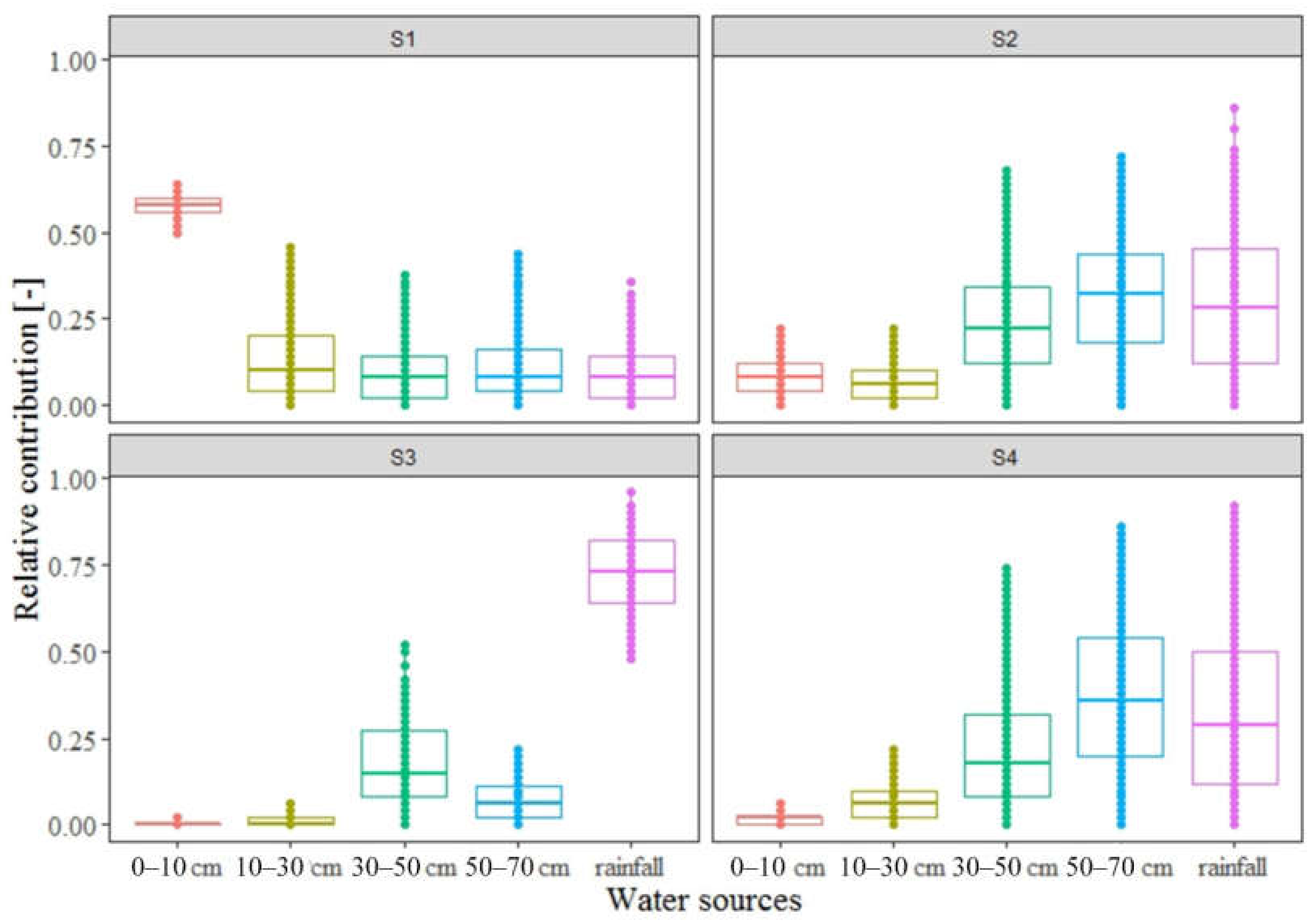
3.3. Water Uptake Patterns of Nitraria

Results of the analysis of source contributions to the mean isotopic compositions of the species using mixing model IsoSource are presented in Figure 4. It reveals distinct differences in the vegetation water source division among the four.
S1, just 1 day after the precipitation pulse, meteorologic water was the dominant contributor to the water demand of Nitraria, making up almost 75 percent (mean). S2 and S4, five days later, share a highly similar shape indicating that the influence of rainfall decreases and meanwhile 30–70 cm soil water absorbed increase gradually resulting in rainfall, 30–50 cm and 50–70 cm soil water share 30 percent, respectively. S3, 10 days after the meteorologic event, the most contributive source was shifted to 0–10 cm soil water, with a major share of about 60%.
The observations provide indicators for roots activity and water uptake strategies of the species. Shortly after a precipitation pulse, Nitraria could use the highly available meteorologic water immediately in huge proportion, which represents the strong short-term impacts of precipitation events on plant roots water uptake and is consistent with related views for arid vegetation worldwide [1,18]. As time goes on, the direct influence of precipitation pulse gradually recedes while the infiltrated rainfall significantly raise the availability of deeper soil water, leading to an appropriate activation for deeper roots activity and thus an elevated relative uptake from deeper soil, which agrees with our research results obtained on other desert species and can be considered as the indirect effect of unpredictable precipitation events in arid regions. From this case study, the short-term impacts of a common precipitation pulse are found to last 5 to 10 days. With the further passage of time and at the end of influences of precipitation pulses, the species majorly depends on its extremely extensive roots developed in surface-near lateral zone to extract bulky soil to acquire required water, which corresponds to the water use strategy of T. sericea, a shrub species at semi-arid regions of Africa, found by Beyer et al. [1]. Considering the very low soil moisture content in arid areas, it is a safe inference, from authors’ perspective, that a large part of the water used from surface-near soil is brought from much deeper soil layers and/or groundwater by vegetation deep tap roots via their hydraulic lifting function, which has been long reported in related literatures [29,30]. The dominant proportional uptake to the shallow soil water pronouncedly confirms the maintenance of activities for Nitraria surface-near shallow roots, which is responsible for its well-known windbreak and sand fixing function [16,31].

4. Conclusions

Two major conclusions regarding the study of root water uptake patterns for Nitraria during the growth period differing in time interval from a precipitation event in arid regions can be drawn from our observations via quantitative stable water isotope tracing. First, the precipitation events exert periodic significant pulse-effects on vegetation water uptake through direct absorption and activation of deep root activity at a certain depth. ~ 50 cm is the maximum infiltration depth of a common precipitation in such typical arid deserts as the Northwest China and its periodic strong function lasts 5 to 10 days. Second, in most occasions without rainfall, Nitraria relies on its extremely extensive shallow roots in surface-near lateral zone to extract massive soil as well as the Hydraulic lifting mechanism to survive drought.
The feature of this paper is being targeted at water uptake strategies of a desert species during growth period in arid areas of Northwest China considering the dynamic effects of precipitation events, and the results will be significant for a boomed knowledge on water transport processes within soil-vegetation cycle and contribute to the sustainable management and maintenance of desert ecosystem in arid areas.
In future research, the vertical range of the study might be extended to the complete unsaturated zone for the further investigation of vegetation water uptake from deeper soil layers and/or groundwater. In addition, artificial isotopic labeling applied to the eco-hydrological processes would be a potential.

Author Contributions

Conceptualization, H.D. and Z.C.; Data curation, J.H.; Formal analysis, M.Y.; Funding acquisition, J.H.; Investigation, M.Y. and J.W.; Methodology, Z.C.; Project administration, H.D.; Resources, G.Z.; Software, H.D.; Supervision, G.Z.; Validation, J.W.; Visualization, H.D.; Writing—original draft, H.D.; Writing—review & editing, Z.C. and G.Z. All authors have read and agreed to the published version of the manuscript.

Funding

This research was funded by China Geological Survey grant number SK201909, SK202107 and G202203-4. The APC was funded by China Geological Survey grant number SK202107.

Institutional Review Board Statement

Not applicable.

Informed Consent Statement

Not applicable.

Data Availability Statement

The datasets used or analyzed during the current study are available from the corresponding author on reasonable request.

Conflicts of Interest

The authors declare no conflict of interest.

References

  1. Beyer, M.; Koeniger, P.; Gaj, M.; Hamutoko, J.T.; Wanke, H.; Himmelsbach, T. A Deuterium-based labeling technique for the investigation of rooting depths, water uptake dynamics and unsaturated zone water transport in semiarid environments. J. Hydrol. 2016, 533, 627–643. [Google Scholar] [CrossRef]
  2. Youri, R.; Mathieu, J. Reviews and syntheses: Isotopic approaches to quantify root water uptake: A review and comparison of methods. Biogeosciences 2017, 14, 2199–2224. [Google Scholar]
  3. Xu, J.; Guo, Z.Y.; Li, Z.; Li, F.J.; Xue, X.K.; Wu, X.R.; Zhang, X.M.; Li, H.; Zhang, X.D.; Han, Q.F. Stable oxygen isotope analysis of the water uptake mechanism via the roots in spring maize under the ridge–furrow rainwater harvesting system in a semi-arid region. Agric. Water Manag. 2021, 252, 106879. [Google Scholar] [CrossRef]
  4. Germon, A.; Laclau, J.P.; Robin, A.; Jourdan, C. Tamm Review: Deep fine roots in forest ecosystems: Why dig deeper? For. Ecol. Manag. 2020, 466, 118135. [Google Scholar] [CrossRef]
  5. Eamus, D.; Zolfaghar, S.; Villalobos-Vega, R.; Cleverly, J.; Huete, A. Groundwater-dependent ecosystems: Recent insights, new techniques and an ecosystem-scale threshold response. Hydrol. Earth Syst. Sci. Discuss. 2015, 12, 4677–4754. [Google Scholar]
  6. Bertrand, G.; Goldscheider, N.; Gobat, J.M.; Hunkeler, D. Review: From multi-scale conceptualization to a classification system for inland groundwater-dependent ecosystems. Hydrogeol. J. 2012, 20, 5–25. [Google Scholar] [CrossRef] [Green Version]
  7. Beyer, M.; Hamutoko, J.T.; Wanke, H.; Gaj, M.; Koeniger, P. Examination of deep root water uptake using anomalies of soil water stable isotopes, depth-controlled isotopic labeling and mixing models. J. Hydrol. 2018, 566, 122–136. [Google Scholar] [CrossRef]
  8. Barbeta, A.; Peñuelas, J. Relative contribution of groundwater to plant transpiration estimated with stable isotopes. Sci. Rep. 2017, 7, 10580. [Google Scholar] [CrossRef] [Green Version]
  9. Berry, Z.C.; Evaristo, J.; Moore, G.; Poca, M.; Steppe, K.; Verrot, L.; Asbjornsen, H.; Borma, L.S.; Bretfeld, M.; Hervé-Fernández, P.; et al. The two water worlds hypothesis: Addressing multiple working hypotheses and proposing a way forward. Ecohydrology 2017, 11, e1843. [Google Scholar] [CrossRef]
  10. Pierret, A.; Maeght, J.-L.; Clément, C.; Montoroi, J.-P.; Hartmann, C.; Gonkhamdee, S. Understanding deep roots and their functions in ecosystems: An advocacy for more unconventional research. Ann. Bot. 2016, 4, 130. [Google Scholar] [CrossRef] [Green Version]
  11. Brum, M.; Vadeboncoeur, M.A.; Ivanov, V.; Asbjornsen, H.; Saleska, S.; Alves, L.F.; Penha, D.; Dias, J.D.; Aragão, L.E.O.C.; Barros, F.; et al. Hydrological niche segregation defines forest structure and drought tolerance strategies in a seasonal Amazon forest. J. Ecol. 2019, 107, 318–333. [Google Scholar] [CrossRef] [Green Version]
  12. Knighton, J.; Conneely, J.; Walter, M.T. Possible increases in flood frequency due to the loss of Eastern Hemlock in the Northeastern United States: Observational insights and predicted impacts. Water Resour. Res. 2019, 55, 5342–5359. [Google Scholar] [CrossRef]
  13. Brinkmann, N.; Eugster, W.; Buchmann, N.; Kahmen, A. Species-specific differences in water uptake depth of mature temperate trees vary with water availability in the soil. Plant. Biol. 2019, 21, 71–81. [Google Scholar] [CrossRef] [Green Version]
  14. Gómez-Navarro, C.; Pataki, D.E.; Bowen, G.J.; Oerter, E.J. Spatiotemporal variability in water sources of urban soils and trees in the semiarid, irrigated Salt Lake Valley. Ecohydrology 2019, 12, e2154. [Google Scholar] [CrossRef]
  15. Antunes, C.; Barradas, M.C.D.; Zunzunegui, M.; Vieira, S.; Pereira, Â.; Anjos, A.; Correia, O.; Pereira, M.J.; Máguas, C. Contrasting plant water-use responses to groundwater depth in coastal dune ecosystems. Funct. Ecol. 2018, 32, 1931–1943. [Google Scholar] [CrossRef]
  16. Jiang, S.X.; An, F.B.; Ma, J.P.; Zhao, P.; Liu, H.J.; Liu, S.J. Water sources of Nitraria tangutorum nebkhas and its response to ecological water transfer in Qingtu lake in lower reaches of Shiyang river. J. Arid. Land Resour. Environ. 2019, 33, 176–182, (in Chinese with English abstract). [Google Scholar]
  17. Li, Y.F.; Yu, J.J.; Lu, K.; Wang, P.; Zhang, Y.C.; Du, C.Y. Water sources of Populus euphratica and Tamarix ramosissima in Ejina Delta, the lower reaches of the Heihe River, China. Chin. J. Plant. Ecol. 2017, 41, 519–528, (in Chinese with English abstract). [Google Scholar]
  18. Debandi, G.; Rossi, B.E.; Villagra, P.E.; Giantomasi, M.A.; Mantován, N.G. Spatial and temporal synchronicity in the phenological events of Prosopis flexuosa in the Central Monte Desert. Rev. De La Fac. De Cienc. Agrar. 2020, 52, 148–160. [Google Scholar]
  19. Duran-Llacer, I.; Arumí, J.L.; Arriagada, L.; Aguayo, M.; Rojas, O.; González-Rodríguez, L.; Rodríguez-López, L.; Martínez-Retureta, R.; Oyarzún, R.; Singh, S.K. A new method to map groundwater-dependent ecosystem zones in semi-arid environments: A case study in Chile. Sci. Total Environ. 2022, 816, 151528. [Google Scholar] [CrossRef] [PubMed]
  20. Meglioli, P.A.; Villagra, P.E.; Aranibar, J.N.; Magliano, P.N.; Jobbagy, E.G. Sensitivity of groundwater levels and chemistry to partial removal of vegetation in Prosopis woodlands of the Monte Desert, Argentina. J. Hydrol. 2021, 598, 128264. [Google Scholar] [CrossRef]
  21. Phillips, D.L.; Gregg, J.W. Source partitioning using stable isotopes: Coping with too many sources. Oecologia 2003, 136, 261–269. [Google Scholar] [CrossRef]
  22. Duan, D.Y.; Ouyang, H. Application of stable hydrogen and oxygen isotope in analyzing plant water use sources. Ecol. Environ. 2007, 16, 655–660. [Google Scholar]
  23. Ellsworth, P.Z.; Williams, D.G. Hydrogen isotope fractionation during water uptake by woody xerophytes. Plant. Soil 2007, 291, 93–107. [Google Scholar] [CrossRef]
  24. Xing, D.; Xiao, J.J.; Han, S.Y.; Peng, G.H.; Fu, W.T.; Jia, Y.L. Water absorption source analysis of mulberry roots based on stable isotopes in rocky desertification area. Trans. Chin. Soc. Agric. Eng. 2019, 35, 77–84. [Google Scholar]
  25. Liu, J.R.; Song, X.F.; Yuan, G.F.; Sun, X.M.; Yang, L.H. Stable isotopic compositions of precipitation in China. Tellus B 2014, 66, 39–44. [Google Scholar] [CrossRef] [Green Version]
  26. Xing, X.; Chen, H.; Zhu, J.; Chen, T. Water sources of five dominant desert species in Nuomuhong area of Qaidam Basin. Acta Ecol. Sin. 2014, 34, 6277–6286. [Google Scholar]
  27. Zhou, T.H.; Zhao, C.Y.; Wu, G.L.; Jiang, S.W.; Yu, Y.X.; Wang, D.D. Application of stable isotopes in analyzing the water sources of Populus euphratica and tamarix ramosissima in the upstream of tarim river. J. Desert Res. 2017, 37, 124. [Google Scholar]
  28. Wang, Y.Y.; Chen, Y.P. Research progress in water uptake models by plant roots. Acta Prataculturae Sin. 2017, 26, 214–225. [Google Scholar]
  29. Ceperley, N.; Mande, T.; Rinaldo, A.; Parlange, M.B. Evidence of hydraulic lift for pre-rainy season leaf out and dry-season stem water enrichment in Sclerocarya birrea, a tropical agroforestry tree. EGU Gen. Assem. Conf. Abstr. 2014, 16, 8261. [Google Scholar]
  30. Yuan, G.F.; Zhang, P.; Xue, S.S.; Zhuang, W. Change characteristics in soil water content in root zone and evidence of root hydraulic lift in Tamarix ramosissima thickets on sand dunes. Chin. J. Plant. Ecol. 2012, 36, 1033–1042, (in Chinese with English abstract). [Google Scholar] [CrossRef]
  31. Du, J.H.; Yan, P.; Dong, Y.X. The progress and prospects of nebkhas in arid areas. J. Geogr. Sci. 2010, 5, 712–728. [Google Scholar] [CrossRef]
Figure 1. DEM and river system of the Minqin Country and the relative geographical location of Qingtu Lake (study area) as well as sampling spots.
Sustainability 14 08203 g001
Figure 2. Dual-isotope plot (including according regression equations) of various samples collected and analyzed through the field campaign.
Sustainability 14 08203 g002
Figure 3. δD (as well as that of meteorologic water) and δ18O (including that of respective xylem water) profils of soil water.
Sustainability 14 08203 g003
Figure 4. Boxplots of source water relative uptake (estimated by IsoSource realizations) in the four spots considering the five contributors.
Sustainability 14 08203 g004
Publisher’s Note: MDPI stays neutral with regard to jurisdictional claims in published maps and institutional affiliations.

