1. Introduction
Geo-ecotourism is the perfect blend of geotourism, which encourages the population to become interested in the sustainable preservation of places by allowing them to appreciate historical heritage sites or geological landscapes and ecotourism, which aims at preserving the place’s natural and cultural resources. It is a combination of the two words ‘geo’ and ‘eco’, implying that it refers to the interrelationships between abiotic components, such as natural landscapes or heritage sites, and biotic components, such as the flora and fauna and local residents of a place [
1]. Geo-ecotourism seeks to capture the essence of a place. Geo-ecotourism is a type of travelling that helps us to preserve or enhance the environment, indigenous features, cultural aesthetics and the geographical uniqueness of a given place. Ecotourism mainly comprises cherishing the flora and fauna of a place, the interdependency between the environment and the indigenous local people and the idiosyncratic culture and norms of that region. Geotourism, on the other hand, prizes historic and archaeological structures, traditional architecture, geological landscape and geological relics found in that place. Geological relics include structures that have been brought up from under the Earth’s surface by both endogenic and exogenic processes, such as karst topography, soil profiles, etc. Putting these two types of tourism together forms the concept of geo-ecotourism, which is new and thus has enormous potential.
The tourism industry of India is ranked seventh in the world, as reported by the World Travel and Tourism Council [
2] and is considered one of the most significant contributors to the world’s GDP. In India, for the last decade, the tourism trend has shown a sharp rise. Most tourists travel with a variety of intentions, and hence, geo-ecotourism provides plenty of options for a tourist. People have started travelling to lesser-known destinations alongside popular vacation spots. The mass tourism industry has enabled even low-income and middle-income groups to travel to places they have never travelled to before. The improvement in transport and communication networks and the drop in the prices of domestic travel, together with the increase in the purchasing power of people, have made domestic tourism widely popular. In 2019, more than 2.3 billion domestic trips were made within the country, an improvement over the previous year [
3]. However, regrettably, this has caused a lot of environmental degradation. As the influx of tourists has increased in these secluded spots, which are mostly detached from the urban pace of life and rich with picturesque beauty, the demand for luxury staycation experiences has also increased, increasing the pressure on these places. In addition, over the years, the Geological Survey of India (GSI) has identified many geographically unique and exotic landscapes suitable for tourism sites, but there is still a lack of initiative in terms of promoting, sustaining and maintaining these sites. Given the unawareness and ignorance of such sites and the significant menace of over-tourism, geo-ecotourism may be the only way to popularize and commercialize these tourism sites while simultaneously conserving them, which would benefit not only our country but also the entire world.
Previous research on geo-ecotourism, ecotourism and related issues has been undertaken [
1,
4,
5,
6,
7,
8,
9,
10,
11,
12,
13,
14,
15,
16,
17,
18,
19,
20,
21,
22] to understand recent trends and the logical coherence of these patterns. In recent years, in the area of sustainable tourism, geological parks have become a well-appreciated topic around the world. With rising trends of geo-tourism and geo-ecotourism in Asian countries such as Japan, Turkey, Indonesia, etc., geological parks promise to conserve landscapes and geographical structures, alongside making these structures popular among tourists [
1,
14,
15,
16,
17,
18,
19,
20,
21,
22]. However, geo-ecotourism differs from the concept of geological parks, as it focuses on the central aspects of geotourism—that is, the preservation of geographical landscape and land formation processes—and of ecotourism—primarily concentrating on the interrelationship between the ecosystem and the communities within that place.
Numerous studies have been performed on ecotourism, but most of the works on geo-ecotourism have been completed at the microlevel and are mostly related to other countries [
1,
14,
21,
22]. While some significant works on ecotourism and geotourism in India [
23,
24,
25,
26,
27,
28,
29,
30,
31,
32,
33,
34,
35,
36,
37,
38,
39,
40,
41], and specifically in West Bengal [
42,
43,
44,
45,
46,
47,
48,
49,
50,
51,
52], have been performed, very few studies have considered site suitability analyses [
53,
54,
55,
56] or the potential applicability of GIS [
16,
17,
19,
20,
57,
58,
59,
60,
61,
62]. Therefore, this kind of study on geo-ecotourism is incredibly new for India and especially for West Bengal. Thus, the rationale of the current study is that it aims to cultivate geospatial techniques to promote geo-ecotourism, and for this purpose, the Analytical Hierarchy Process (AHP) method is employed to assess site suitability and determine potential geo-ecotourism zones in West Bengal.
West Bengal, in India, has strong potential for developing geo-ecotourism sites due to the provision of biodiversity hotspots of the north-east Himalayan region, a portion of which was found to be advancing into its northern part. For example, the Alipurduar district of the state has vast scope for developing geo-ecotourism with its lush green scenery and hilly streams. Aside from this, the state’s central part, comprising Birbhum, Bankura, Purulia, Paschim Bardhaman, Purba Bardhaman, Jhargram and Purba Medinipur districts, has immense potential for developing geo-ecotourism due to the presence of the hills, river valleys, caves and badland areas. This lateritic landscape might not be suitable for cultivation, but the picturesque beauty of the region induces the provision of tourism. The Gangani badlands region, formed during the Pleistocene period, is famously known as the ‘Grand Canyon of West Bengal’. The aesthetic beauty of this region lies within the escarpments, buttes, mesas, caves, ridges and geomorphological sites. The Purulia district is endowed with geoheritage sites that are attractive to tourists and holds immense aesthetic value. Places such as the Durgabera dam, Bhanratongri Hill and Garpanchkot and Jaychandi hills are the most popular among tourists, encompassing the very best geoheritage values. In contrast, the Pordih Hills, Tamakhun Mine and Jabar Hills belong to the lesser-known potential geo-ecotourism sites. Thus, this paper discusses the expansion of the newer alternative geo-ecotourism industry and its potential in West Bengal rather than of mass tourism or other types of tourism. The prime objective of the present study was to look at the scope and potentiality of geo-ecotourism in West Bengal considering its physiography, LULC etc. and recognize tourist spots by dividing the state into probable geo-ecotourism zones and demonstrating their mapping. Furthermore, we recognized and categorized the site suitability of geo-ecotourism spots with the help of the AHP method and mapped out the study region by employing geospatial techniques to improve the prospect of tourism.
2. Materials and Methods
2.1. Study Area
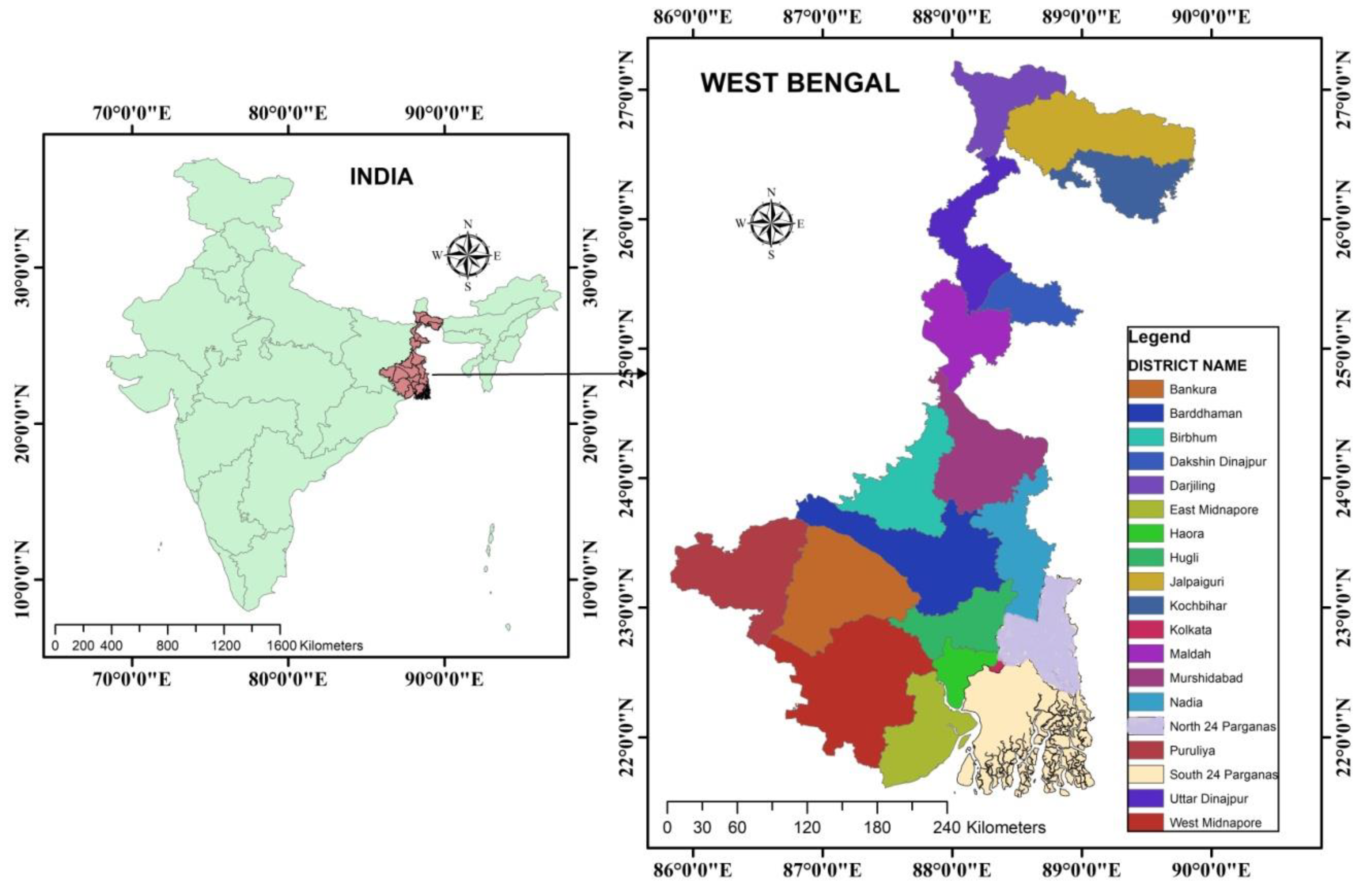
The current study was carried out in one of the smallest states of India with a sizeable population base, i.e., West Bengal (
Figure 1). This state is positioned in the eastern part of India and surrounded by countries, such as Bangladesh in the east, Bhutan in the north and many states, such as Sikkim in the north, Assam in the northeast and Bihar and Jharkhand in the west.
The capital of the state is Kolkata, which is a well-known megacity located on the left bank of the Hooghly River. West Bengal is located between 21°25′ N 27°13′ N and 85°50′ E 89°50′ E. The state previously had 19 districts; since 2018, however, there have been 23 districts.
The total population of West Bengal is 91.3 million (Census, 2011), which constitutes about 7.54% of the total population of India, and this figure reached approximately 100.9 million in the year 2020. The population density is extremely high (1028 persons/km
2) in the state with a high rate of growth (13.84% in 2011) [
63]. The Gross State Domestic Product (GSDP) of the state is predicted to exceed 14.44 trillion in 2020–2021 [
2,
64], which signifies that the state has a sound contribution to the National Gross Domestic Product (NGDP). Almost every district has some special features in terms of tourism, and therefore, the state is famous for its landscape and nature, including hills, wildlife, forests and beaches; its cultural, heritage, religious, waterways, traditional, ethnic, urban, rural and tribal aspects; and its historical forms of tourism. Moreover, tourist spots, such as Darjeeling, Kalimpong, Sandakphu, Dooars, Jaldapara, Murshidabad, Gour, Gorumara, Bishnupur, Purulia, Shantiniketan, Belur Math, Dakshineswar, Kalighat, Tarapith, Nabadwip, Mayapur, Digha, Mandarmoni, Bakkhali, Gangasagar, Sundarbans, Kolkata, etc., are known to every tourist who visits or is willing to visit West Bengal [
42,
43,
44,
45,
46,
47,
48,
49,
50,
51,
52].
2.2. Methodology
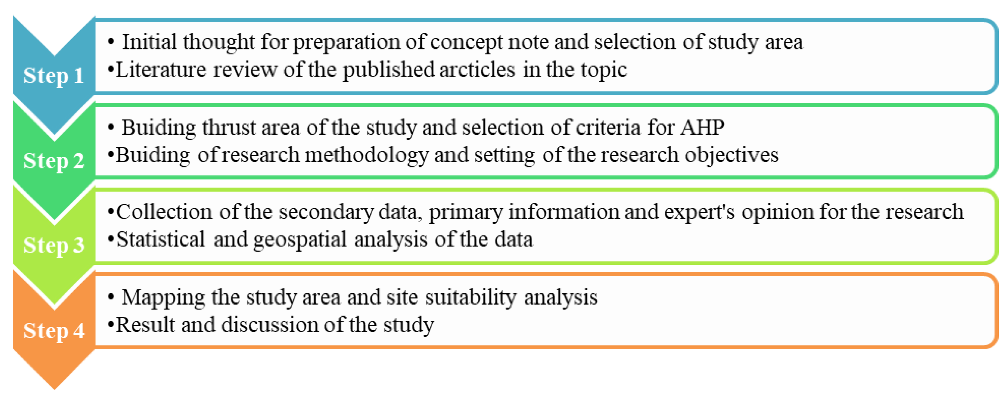
The present study mostly employed secondary data with significant primary information and an expert’s opinions and followed a suitable methodology. The structural framework of the study had some sequential steps, which are graphed below (
Figure 2).
2.3. Data Used
The remotely sensed data and topographical sheets used in the study and the spatial and non-spatial data and their corresponding sources are listed below (
Table 1).
2.4. Data Processing
2.4.1. Data Analysis
The study employed various data using geospatial techniques and methods, such as AHP, statistical techniques, and cartographic tools; therefore, the collected data were analyzed by the ArcGIS (10.3), Edras Imagine (9.2), Mapinfo (10.2) software and Microsoft excel.
2.4.2. Criteria and Numerical Rating for AHP Method
The application of the AHP method was carried out in the current effort twice: initially to examine the suitability of geo-ecotourism in West Bengal and again in a case study of the coastal geo-ecotourism region of West Bengal. Initially, the eleven factors, namely relief, slope, drainage, forest, population concentration, the number of tourist spots, infrastructure, health facilities, road density, scenic beauty and land use land cover were considered for geo-ecotourism suitability in West Bengal. Further, the study concentrated on nine criteria, which included land use/land cover, geomorphology (beach length), existing major infrastructure facilities, existing transport facility, distance of beach from the village, distance from the nearest town, distance from the nearest railway station, distance from nearest cyclone centre and distance from nearest health facility for overlay analysis by the AHP method based on the expert’s opinions to determine the site suitability for geo-ecotourism sites in coastal tracts as a microlevel study.
The comparison between two criteria was carried out using the relative importance scale for two alternatives as suggested by Saaty (1980) [
65] as it is the most widely used in the AHP. Attributing values from 1 to 9 were considered in this study, (
Table 2) which determined the relative importance of an alternative when compared with another alternative.
2.4.3. Steps for Calculation in AHP Method
The application of the AHP method determined geo-ecotourism suitability in West Bengal and site suitability analysis in its coastal tracts in a logical way, the calculation steps of which are described below:
The 1st Step of the AHP procedure is to form a pair-wise comparison between each criterion. The results of the comparison (for each factor pair) describe a term with integer values from 1 (equal value) to 9 (extreme value), where a higher number indicates the chosen factors are considered to be more important and are of greater value.
2nd Step is completing the matrix.
3rd Step is normalization (To make the sum of the weightage of the selected criteria equal to 1 (one), this normalization process was applied. It was performed on the pair-wise comparison matrix and calculated by dividing each criterion’s value from the column with the sum of the corresponding column) and weight determination.
4th Step is calculating the Consistency Ratio (CR).
Here, if the CR > 0.10, then some pair-wise values need to checked, and if the CR < 0.01, then the value is acceptable.
3. Results
3.1. Trend of Tourist Arrival in West Bengal
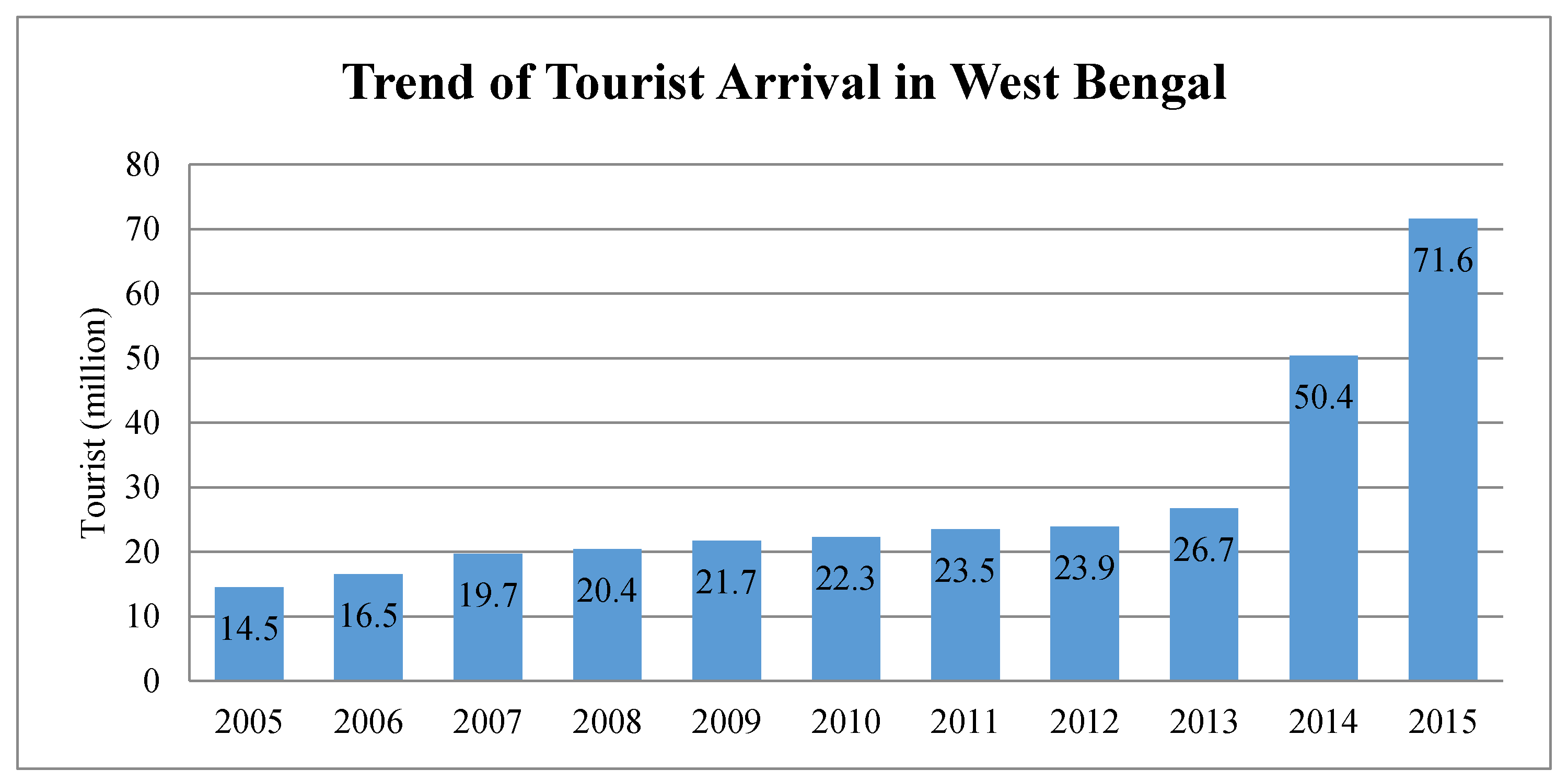
The tourist influx and trend of domestic and foreign tourist arrival in West Bengal are important to note to understand the pressure of tourism bustle in the state and the requirements and scope of geo-ecotourism analysis. According to the Department of Tourism, Govt. of West Bengal, the place experiencing the most tourism is Kolkata (State Capital), followed by Darjeeling with Dooars (foothill region), Darjeeling (hilly region) and Digha, Mandarmani (coastal region) along with Sundarbans and followed by the Rarh region. This reveals that the trend of tourist arrival in West Bengal (
Figure 3) showed a gradually increasing pattern observed from 2005 up to 2013, while a sharp increase was noticed in 2014, which represented an influx of 71.6 million tourists in 2015 [
66,
67,
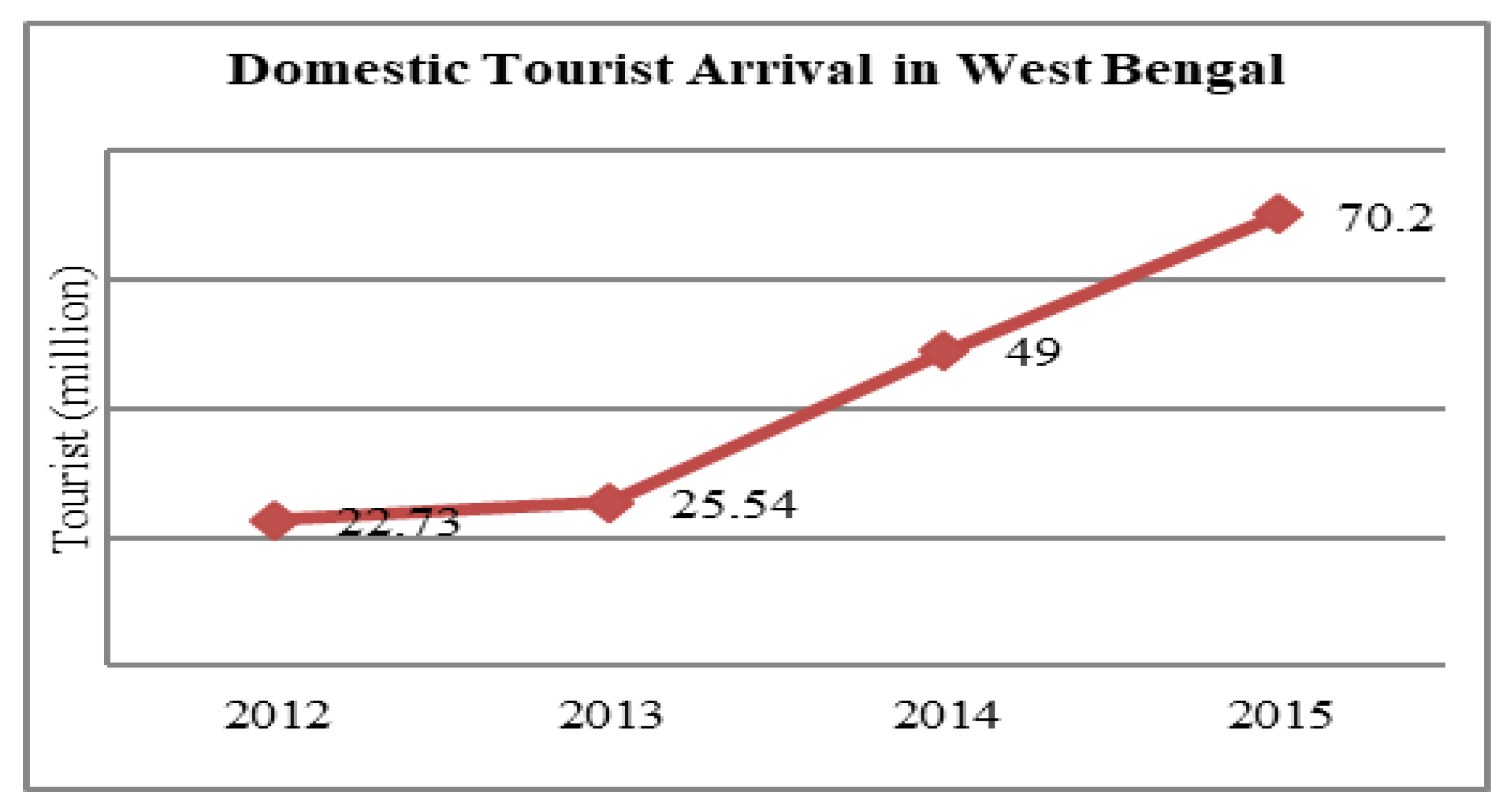
68]. The trend of domestic tourist (
Figure 4 and
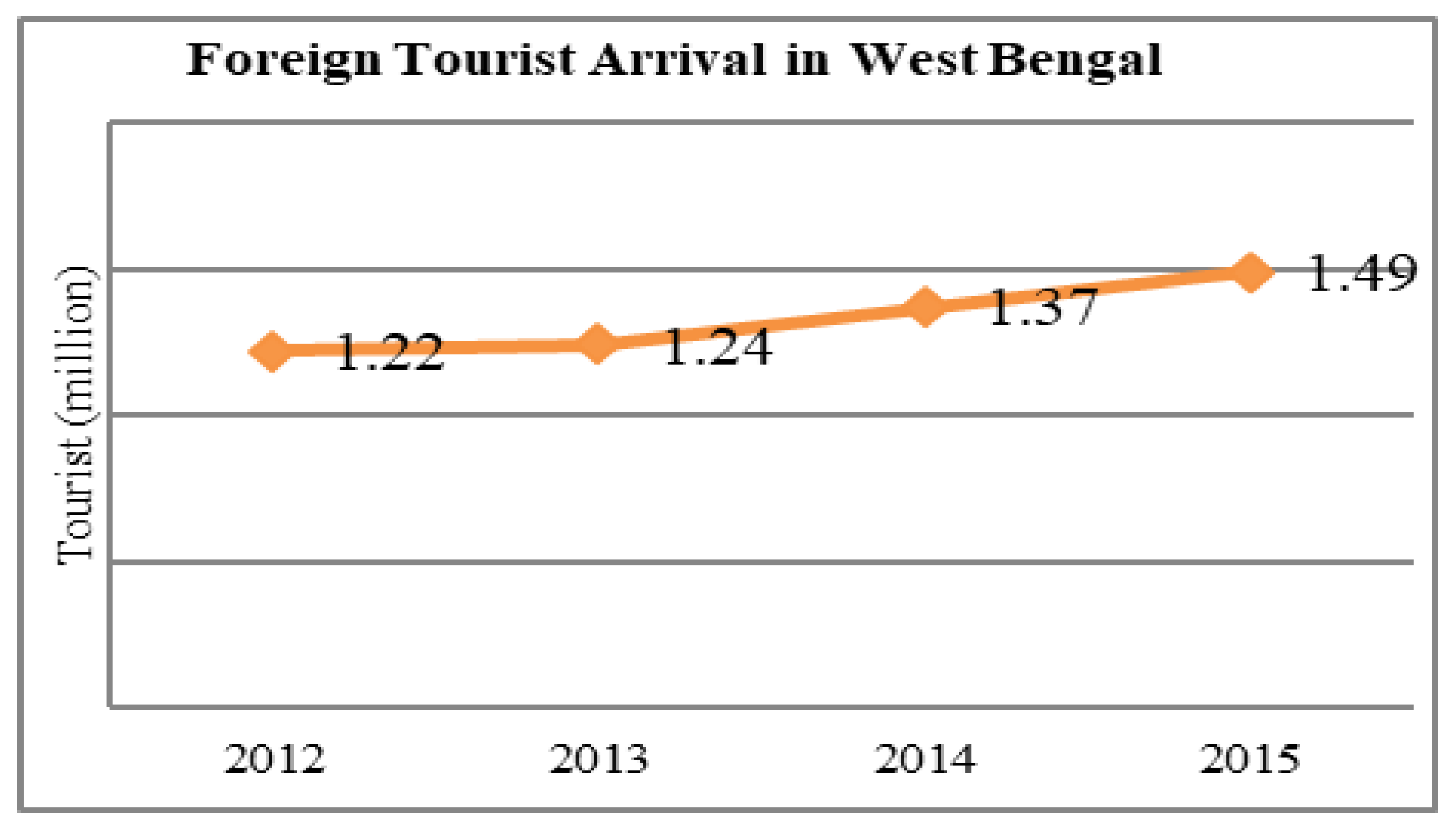
Figure 5) arrival in West Bengal had a sharp increase from the year 2014 and it crossed 70 million in 2015. Moreover, the number of foreign tourists visiting West Bengal has also increased and reached almost 1.5 million in 2015. The state is the fifth highest in the country in terms of foreign arrival (2015). Thus, the tourism budget was increased to 2570 million (2015) from INR 400 to attract further domestic and foreign tourists [
64,
66].
3.2. Tourism in West Bengal and Scope of Geo-Ecotourism
The state of West Bengal has great tourism potential, and it attracts a huge number of domestic and foreign tourists every year in its various familiar and uncommon tourist destinations. The geographical features of the mountain ranges, forests and sea beaches of the state perform as imperative ingredients for the development of tourism. West Bengal is the most unique state in India from a geographical perspective and thus attracts tourists to an assortment of tourism sites throughout the year. The state has the Himalayan range in the north, the Chhotanagpur Plateau in the west and the Bay of Bengal in the south, while the Rajmahal Hills skirt on the north-western side, and the Shillong Plateau stands on the north-eastern border. The heavenly sight of the beautiful Himalayan mountains from Darjeeling with their white snow cover has earned the place the title ‘Queen of the Hill stations’. The Darjeeling Himalayan Railway, more commonly known as the Toy Train, is famous as a ‘World Heritage Site’, pulling in tourists from all over the world who flock to Darjeeling to ride this train [
67,
68]. The green forest, protected sanctuaries and national parks thrive in the Terai region, and the foothills of the Himalayas are extremely popular. Moreover, after Terai, the Dooars region is famous for national parks and wildlife sanctuaries, which are habitats for numerous endangered animals, such as the one-horned rhino, great Indian hornbills, pythons, elephants, leopards, etc. In these regions, the Teesta, Rangit, Murti, Kurti, Lumbini, Jal Dhaka, etc., rivers are found frolicking, the beauty of which attracts tourists from all over the world [
42,
43]. The extreme south of Bengal encompasses mangrove forests nested in the delta formed at the confluence of the Ganga, Brahmaputra and Meghna Rivers, named the Sundarbans, which is a great attraction to tourists for adventure and quietude. The Sundarbans is the largest contiguous mangrove forest in the world and is renowned as a ‘World Heritage Site’ by UNESCO (1987), a ‘Ramsar Site’ (1992) and a ‘Wetland of International Importance’ (2019) [
67,
68]. This is an excellent example of an ongoing ecological process, as the only mangrove habitat for the Panthera Tigris species in the world. The middle of Bengal, covering most parts of the Purulia, Bankura, Medinipur and Bardhhaman districts, constitutes a magnificent extent of rugged, hilly topography in the Rarh plateau region and abundant countryside and inspirations for tourists desiring a nice holiday. The geological structures of the region leave significant imprints on the physical landscape, such as deep canyons in Gangani and Garbeta, formed by the river Shilabati in the Paschim Medinipur district, and are major tourist attractions due to the deep, beautifully carved red rock and amazing scenic beauty. The verdant greenery of the Purulia district, coating the jagged, rising topography comprising the lower elevations of the Eastern Ghats, can be exceptionally attractive to people looking for a taste of adventure [
48,
49,
50,
51,
52]. The lower part of the state is the coastline with several beaches, such as Digha, New Digha, Mandarmani, Tajpur, etc., which is enticing for peaceful, serene vacations. The gently rolling waves along smooth sandy beaches and maritime climate are tourist hooks, and with the support of the state government, these places have emerged as famous tourist spots [
69,
70].
These diverse and rather complex features of West Bengal enhance its geo-ecotourism potentiality and ensure varied outcomes. There are multiples factors, but the current study concentrated on eleven factors, of which the major thrust is thought to be its geological landscapes, geomorphological features and environmental and cultural mosaics, such as population concentration, attractive tourist destinations and their beauty, tourist infrastructural development, road density, accessibility of health facilities, and LULC for developing geo-ecotourism. The expert’s opinions, field observation and literature review were considered when determining the suitability factors of geo-ecotourism in West Bengal and thereafter, these factors were established through AHP using evaluation factors and a judgement matrix (
Table 3). The magnitude of the judgement matrix was determined by the consistency ratio and was found to be significant (
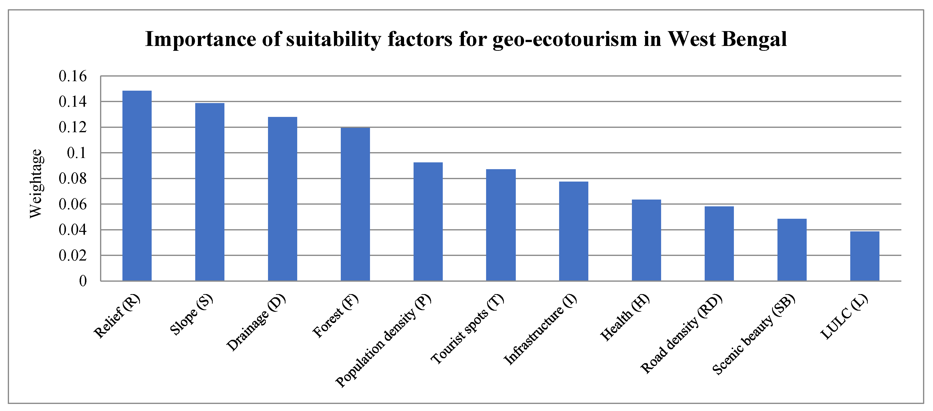
Table 4). According to this judgement, the most important six factors amongst the eleven factors are relief (weight = 0.1484), slope (weight = 0.1387), drainage (weight = 0.1279), forest (weight = 0.1194), population concentration (weight = 0.0925) and number of tourist spots (weight = 0.0871) (
Figure 6). Other factors also play a significant role as the state has diverse features that can attract tourists. Based on the physiographic conditions, the importance of some factors is changeable, and therefore, their contribution in site suitability analysis of geo-ecotourism becomes multifaceted. Thus, to simplify the major factors, they were initially considered for their significance in the geo-ecotourism zones of West Bengal based on their weight analysis; thereafter, all the considerable factors were taken for microlevel analysis of each zone, and the geo-ecotourism spots were located.
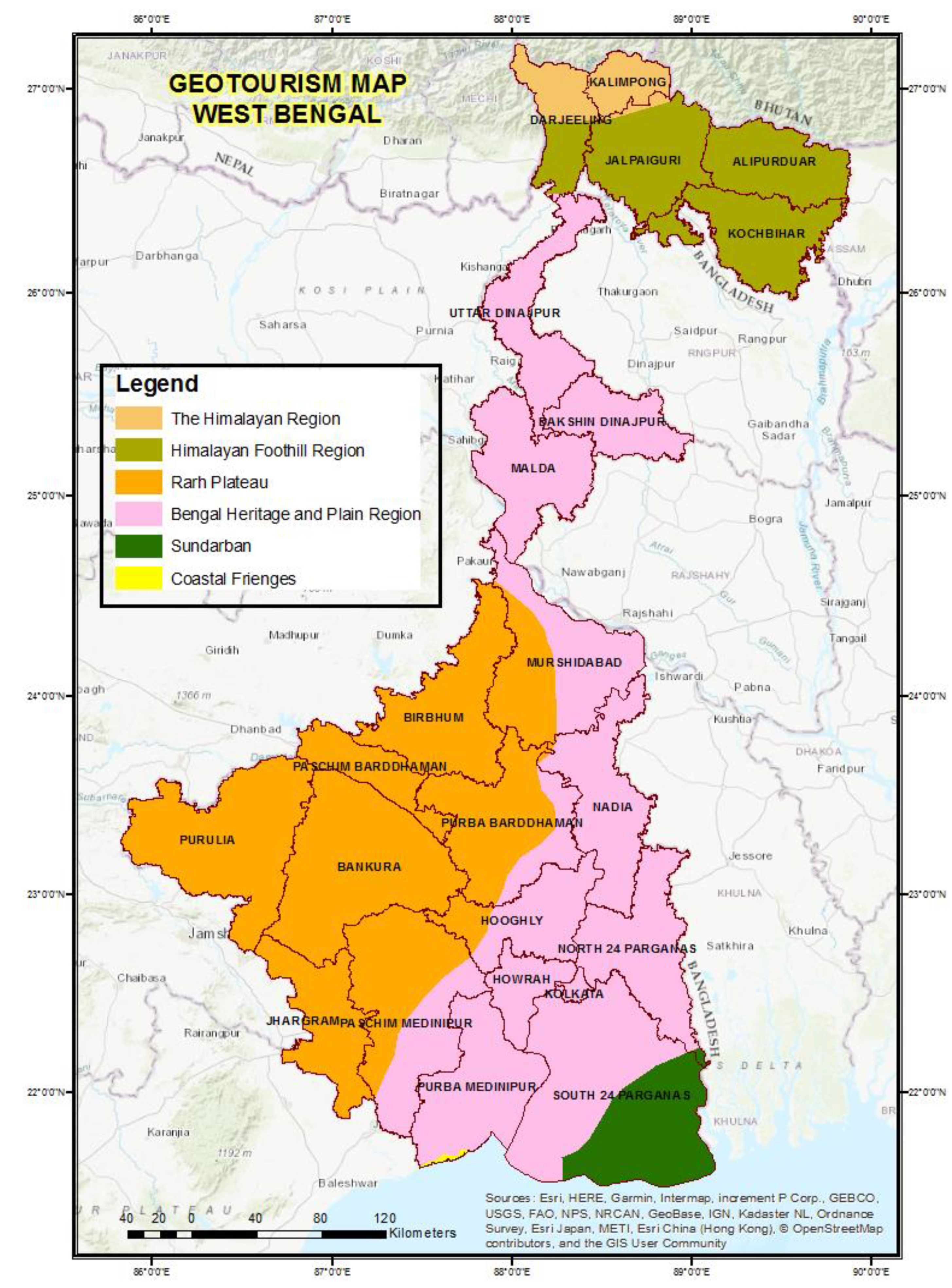
3.3. Geo-Ecotourism Zones of West Bengal and Geo-Ecological Uniqueness
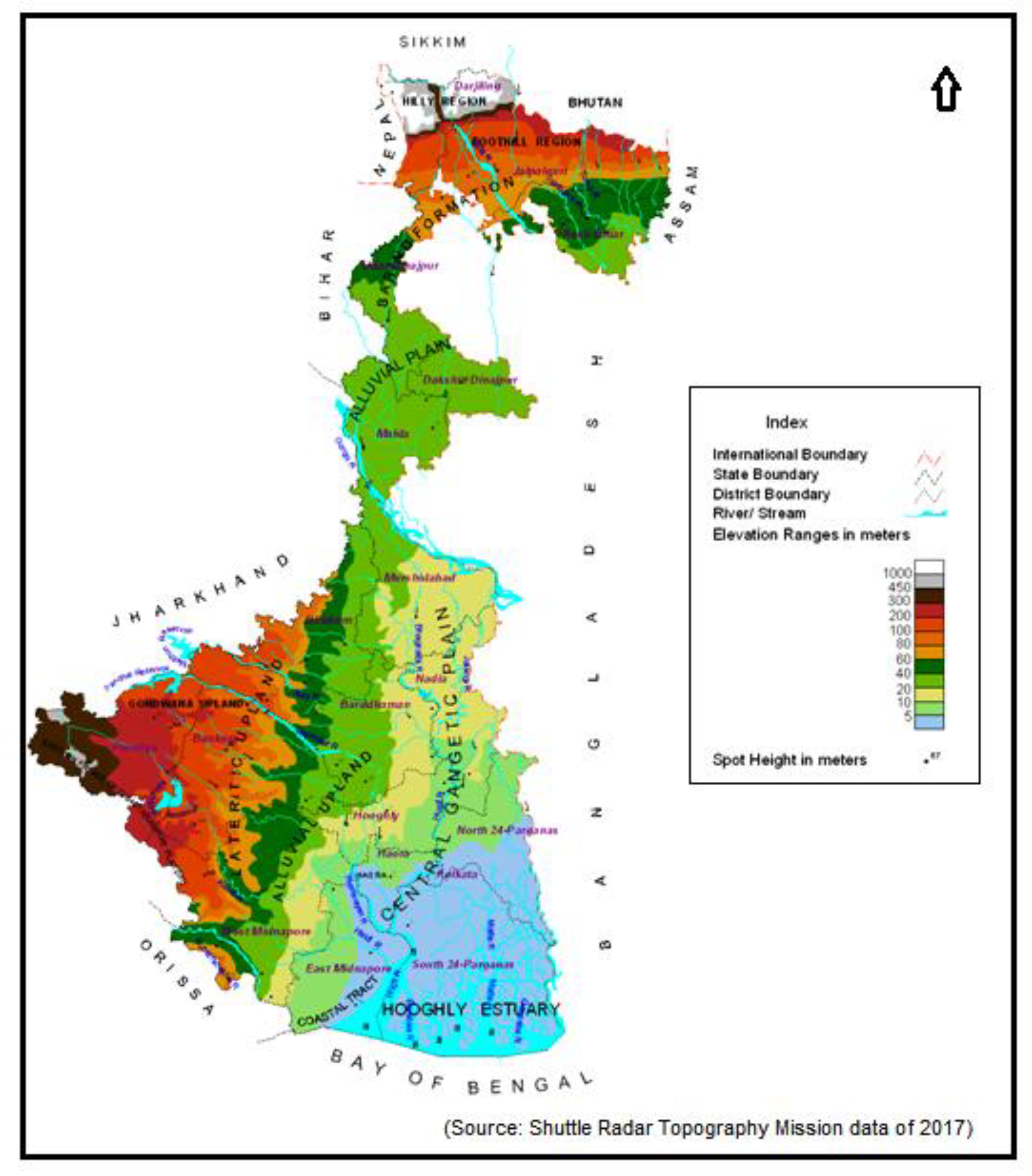
There is significant potential for developing geo-ecotourism in West Bengal because of its diverse geological relics and physiographic settings consisting of hills, inselbergs, tors, springs, waterfalls, ravines, badlands, etc. The geo-ecological uniqueness of the two physiographic divisions, i.e., the northern Himalayan tracts and the southern Gangetic plains, has always attracted tourists from across the world. Thus, the sequential changes in relief, slope, drainage, forest, scenic beauty, LULC, population concentration, etc., in the northern parts with the abrupt elevation of the Himalayan mountain, Sub-Himalayan Dooars region, Lesser Himalayan Terai region in the southern plains and its ascent near the western part, merging into the Chhotanagpur Plateau, result in the area’s significant donation to geo-eco-tourism development. These geological landscapes, geomorphological features and environmental and cultural mosaics create diverse prospects and attractive destinations for developing geo-ecotourism. The physiography (
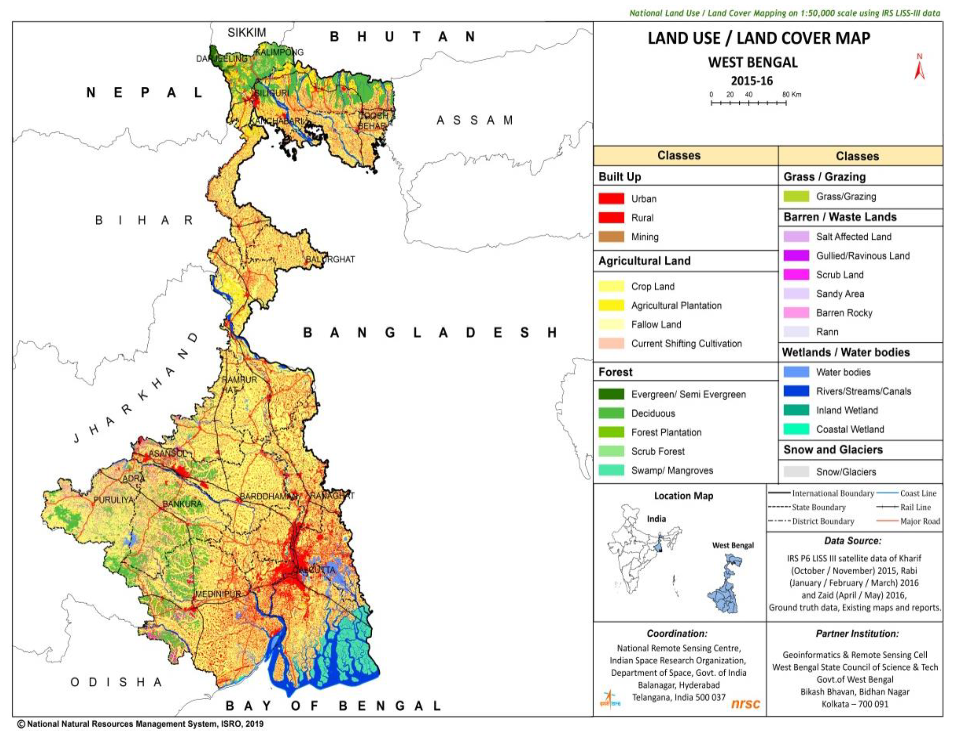
Figure 7) and land use/land cover (LULC) (
Figure 8) of West Bengal is mapped here to arrange the geo-ecotourism zones because it is logical that the barren land and open space can be strategically used for infrastructural development to promote tourism; the forest and wetland area could be useful to build national parks and sanctuaries.
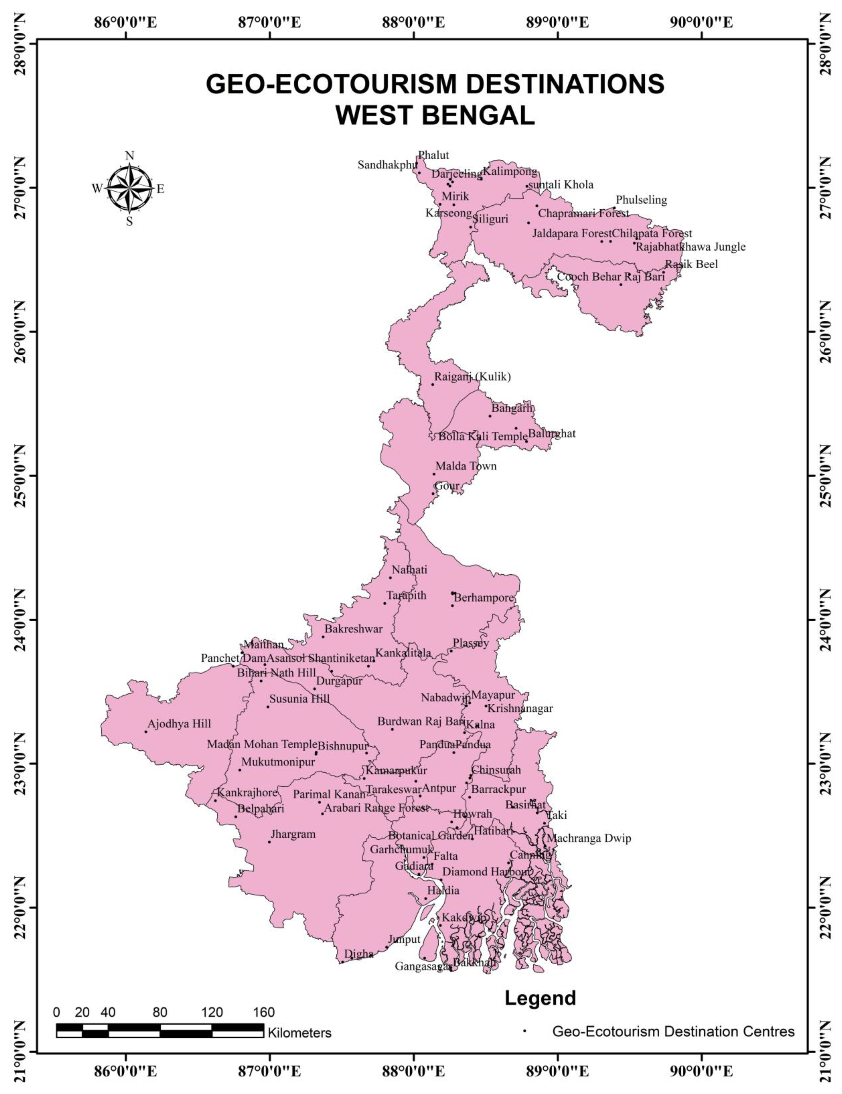
The geo-ecological uniqueness of each geo-ecotourism zones (
Figure 9 and
Figure 10) of West Bengal has been described accordingly to unearth the key tourist spots. The detailed mapping of the potential spots of each zone was also carried out in the study (
Figure 11,
Figure 12,
Figure 13 and
Figure 14).
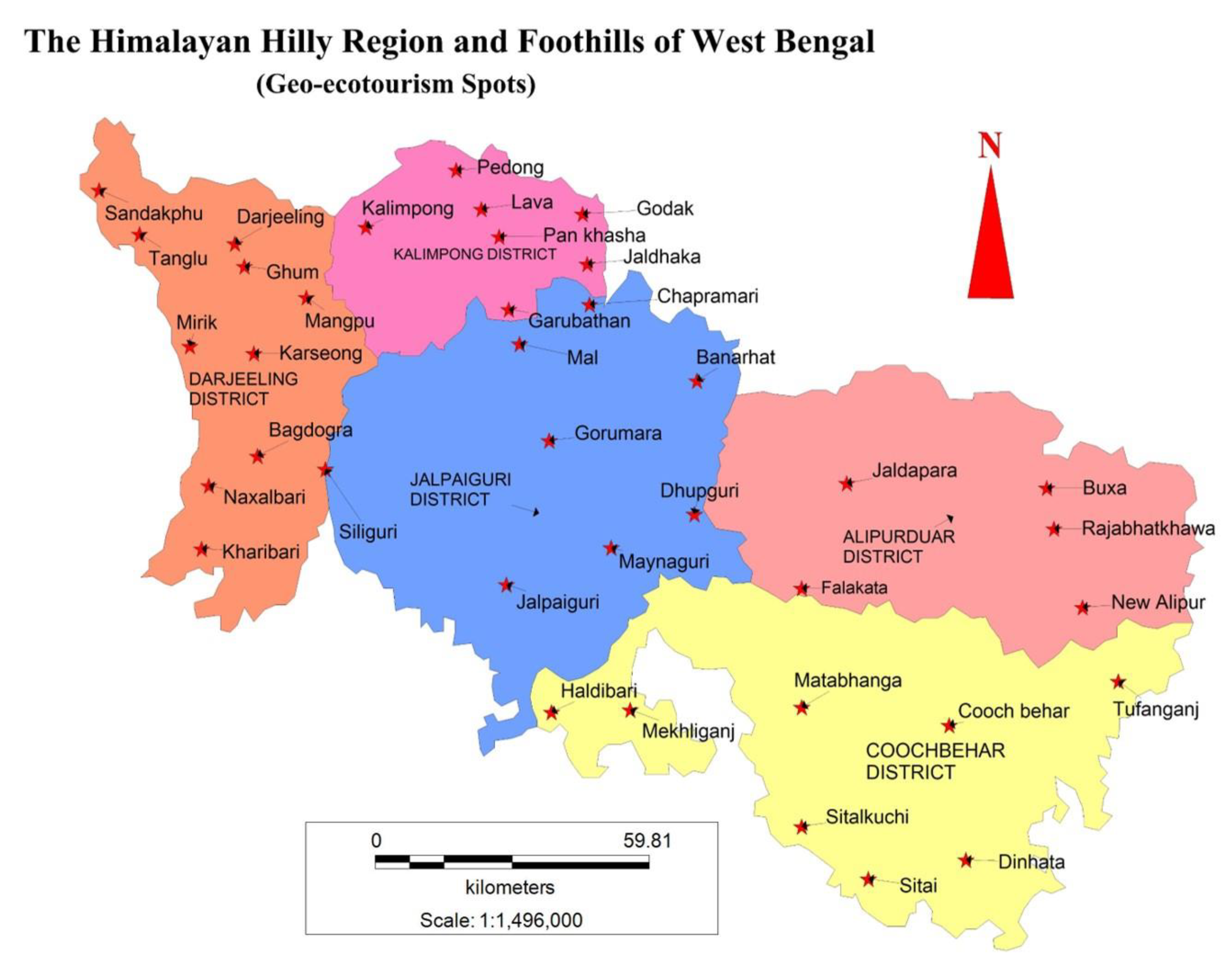
3.3.1. Zone 1: The Himalayan Hilly Region
The entire Darjeeling district and the northern parts of the Alipurduar and Jalpaiguri districts of West Bengal belong to the Himalayan hilly region, which merges into the Eastern Himalayan range, where the climate is favourable throughout the year. Teesta is the main river, running north to south and forming a deep gorge, dividing this region into the eastern and western mountains. This Himalayan range has picturesque mountain peaks with an average height of 2200 m to 1900 m, and the famous Tiger Hill (2567 m) is located here. Mt Everest, Mt Kanchenjonga, Mt Lhotse and Mt Makalu are a few of the highest peaks in the world, which are visible and attract tourists every year. Moreover, the influence of Tibetan and Bhutanese indigenous culture is noticeable in the cuisines and attires in this region. Thus, there are numerous spots that have the capability of promoting geo-ecotourism (
Figure 11) and so many uncommon spots are currently emerging as eco-tourism spots in the region. Some of the potential spots of this region are Kurseong, Kalimpong, Lamahatta, Samsing, Lava lolegaon, Phalut, Takdah, Tinchuley, Sillery Gaon, Mirik, Latpanchar, Srikhola, Sandakphu, Jorpokhri, Palmajua and Rishop.
3.3.2. Zone 2: Terai or Foothill Region
The unique geo-ecological region comprising the Lesser Himalaya and the foothills in the east is known as Terai, and the western fraction is called Dooars, which encompass numerous national parks and wildlife sanctuaries, catering to adventurous tourists and people looking for wildlife photography. The region, which lies just below the Bhabhar, is an area of rocks, gravels and soil eroded from the Himalayas and dotted with clayey marshes, grasslands and wetlands. The lush green forests of Dooars are the home to several endangered species such as the one-horned Indian rhino, Indian elephant, Great Indian Hornbill, red panda, lemurs, leopards, etc. The region is dissected by several rivers, such as Teesta, Torsha, Raidhaka and Jaldhaka, and other small mountain streams, and it is also a place of extensive, wide, stretched mellow green tea estates, creating charisma conducive to geo-ecotourism. The potential spots of this region are Naxalbari, Fashidewa, Panitanki-Kakarvita, Gorumara, Jaldapara, Buxa forest, Dooars-Rongpo, Jhalong, Murti, Bindu, Jayanti, Chillapata, Magurmari Oraon and Kathambari (
Figure 11).
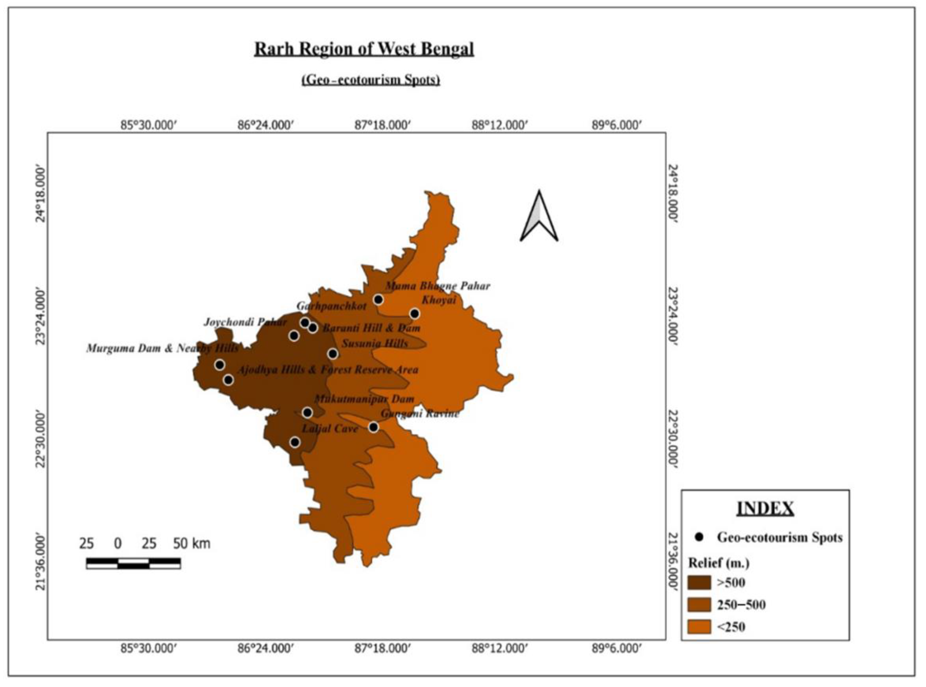
3.3.3. Zone 3: Rarh Plateau Region
The extension of the Chhotanagpur plateau running from the west to the east till the stretch of the Gangetic plains is known as the Rarh plateau region of West Bengal. The western part of Bankura, Bardhaman, Purulia, Birbhum and Paschim Medinipur are found in this region. It has an elevation of about 75 to 500 m, where the low-elevation lateritic badlands, belonging to the Pleistocene era, commonly called Khowai, are widely seen in this region. The highest of these hillocks are the Biharinath and Susunia hills. Small hillocks or Tila are formed due to tectonic activities, and aerial erosions are frequently found in this area, which has transformed this place into an undulating peneplain. The rugged topography of this region provides many opportunities for geo-ecotourism. Furthermore, several rivers such as Damodar, Ajay, Shilabati, Kangsabati, etc., have developed the landscape and added some beauty to the region, which significantly magnetizes tourists. The Gangani Canyon, formed by the river Shilabati in Medinipur, is popularly known as ‘The Grand Canyon of Bengal’. The potential spots of this region are Joychandipahar, Garhpanchkot, Susunia hill, Ayodhya hill, Gargaburu hills, Mathaburu hill, Gangani, Garbetta and Mama-bhagne Pahar (
Figure 12).
3.3.4. Zone 4: Bengal Heritage Plain Land Region
Middle Bengal is an alluvial tract, the combination of old and new alluvium deposits, which is primarily characterized by flat to rolling surfaces, loamy soil and environments with a suitable climate. The Malda, Murshidabad and Nadia districts and parts of the Birbhum and Bardhaman districts belong to this region, which is famous for its heritage sites, physical landscapes and fluvial landforms with distinguished ecological facets, which caters to a large tourist influx. The potential spots of this region are Gour, Adina, Palasi, Hazarduari, Bakreswar, Khoai, Tarapith, Shantiniketan, Nabdwip and Mayapur (
Figure 10 and
Figure 11).
3.3.5. Zone 5: Coastal Fringes
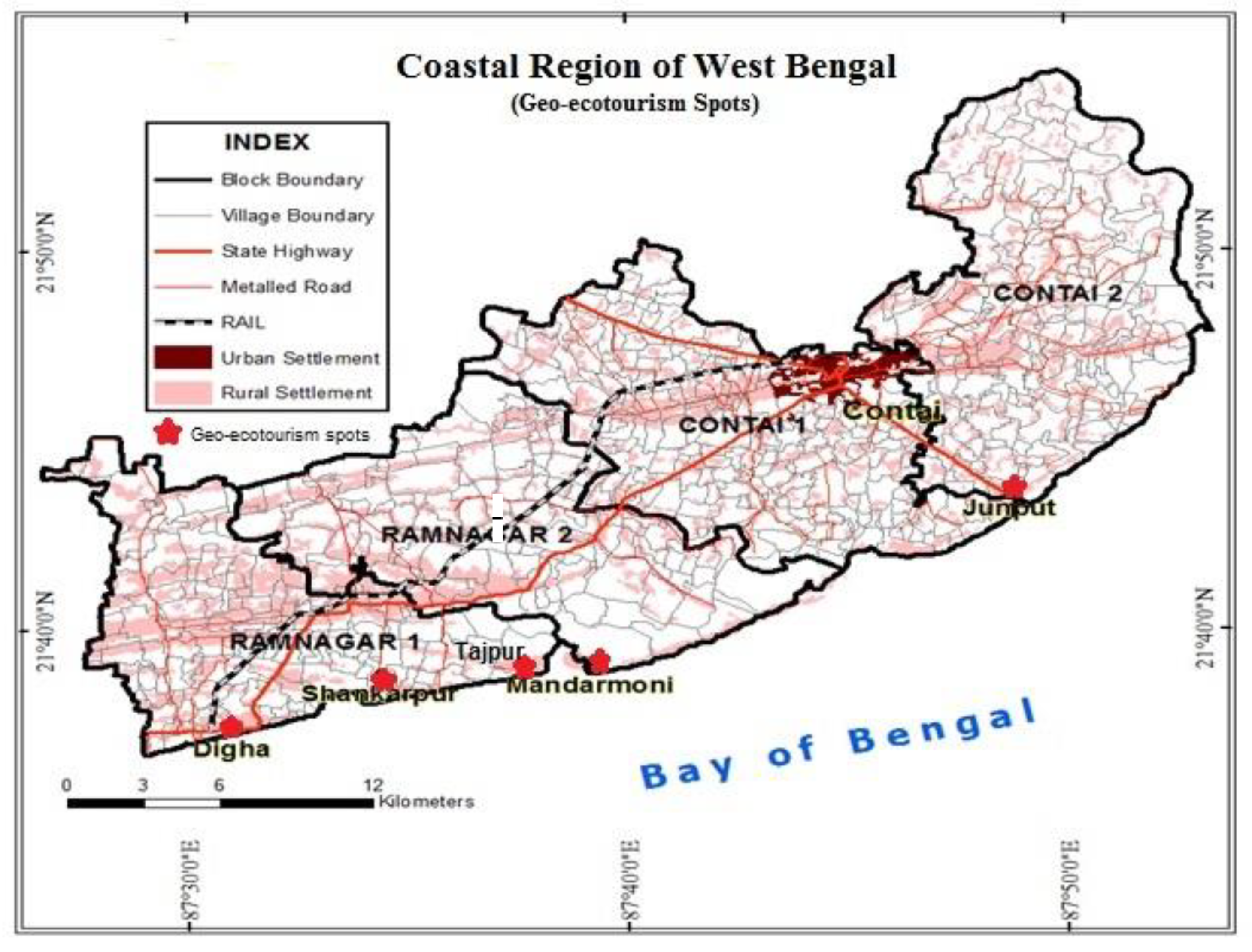
The coastal fringes have smooth beaches with gentle waves due to touching the Bay of Bengal. This plainland region is 158 km long, occupying the southern parts of Purba Medinipur, and extends up to the South 24 Paraganas district. The uniqueness of this region caters to a huge tourist influx throughout the year, and to avoid the drawbacks of such mass tourism, there is immense scope to develop geo-ecotourism in the region. This is the most famous and frequent destination for domestic tourists, despite having tidal inflows and attacks of cyclones. The potential spots of this region are New Digha, Tajpur, Junput, Mandarmoni, Shankarpur and Udaipur (
Figure 13).
3.3.6. Zone 6: Sundarban
This
World Heritage Site and
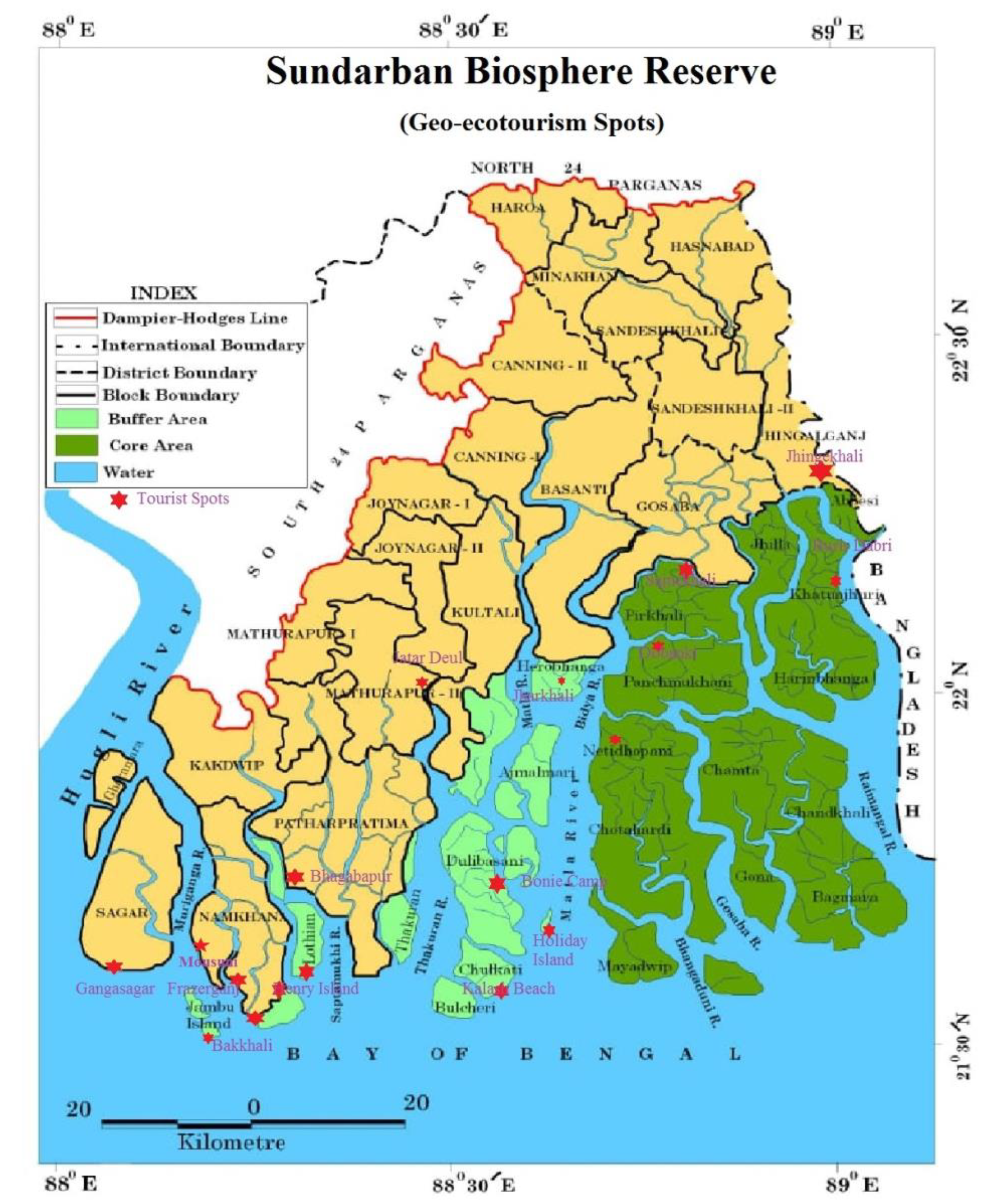
Ramsar Site is a deltaic region, which is associated with the coastal track and was formed at the confluence of the Ganga, Brahmaputra and Meghna rivers. It is the world’s largest mangrove forest, consisting of Sundri trees, and is nestled in a labyrinth of streams and rivers with a series of islands and mudflats. The exceptional biodiversity of the region supports different terrestrial, aquatic and marine habitats, which are popular across the world. It is also the sole habitat for the Royal Bengal tiger (Panthera Tigris) and various other endangered species such as Ganges and Irrawaddy dolphins, estuarine crocodiles and critically endangered endemic river terrapin (Batagur Baska), green turtle, olive ridley turtles, alligators, etc., which are also found to create keen interest amongst tourists. The potential spots are Mausuni, Bakkhali, Henry Island, Gangasagar, Pakhiralay, Bhagbatpur, Dobaki, Burir dabri, Sajnekhali, Sudhanyokhali and Bonni camp (
Figure 14).
3.4. Potential Site Suitability of Geo-Ecotourism in the Coastal Region of West Bengal
3.4.1. Background of Tourism in Coastal Beaches
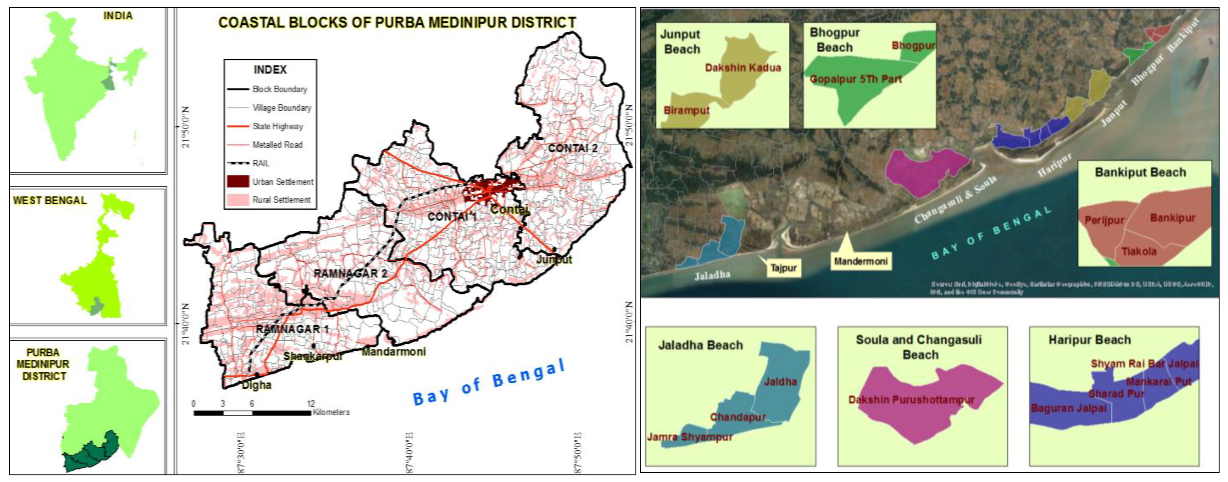
A further intensified outlook of geo-ecotourism was undertaken through checking out the site suitability of the coastal region of West Bengal. Digha, which is located 187 km southwest of Kolkata, is situated in the Purba Medinipur district (
Figure 15), which is the prime spot of the coastal tracts of Bengal [
71]. Since Digha is the foremost choice of tourists [
70,
72], it receives about 1 lakh of foreign tourists and 25 lakh domestic tourists throughout the year (about 43% of the tourist flow of West Bengal) [
67,
68,
72]. The other tourism sites could be found out through employing the site suitability study. Keeping this situation in mind, the coastal area was selected for the case study to find out site suitability using the AHP method. The other significant tourist places (
Figure 15) of the region are Mandarmoni, Tajpur, Shankarpur, Junput, etc. [
67,
71], and they are connected [
71,
73] with the nearest town of Contai. The other local beaches are Jaladha, Soula and Changasuli, Haripur, Junput, Bhogpur and Bankiput, as shown in the figure.
3.4.2. Site Suitability of Coastal Beaches as determined by AHP Method
Considering the nine criteria selected by the expert’s opinions, the site suitability of geo-ecotourism in this coastal region was determined by employing the AHP method and geospatial techniques. The nine selected criteria were land use/land cover, geomorphology (beach length), existing major infrastructure facilities, existing transport facilities, distance of beach from the village, distance from the nearest town, distance from the nearest railway station, distance from nearest cyclone centre and distance from nearest health facility for overlay analysis using weight derived from the AHP method. Each criterion had high, moderate and low suitability levels, but the proportion of influence varied; where land use/land cover (30.33%); beach length (21.42%); and distance of beach from the village (17.05%) have the highest influence capacity. However, it should be kept in mind that the criteria and their influence capacity are perhaps dissimilar in the case of other geo-ecotourism regions of West Bengal. Here, the CR value was calculated using the CI (0.05) and RI (1.32) and found as 0.05, which signifies its acceptance (as it is less than 0.10) [
7,
53,
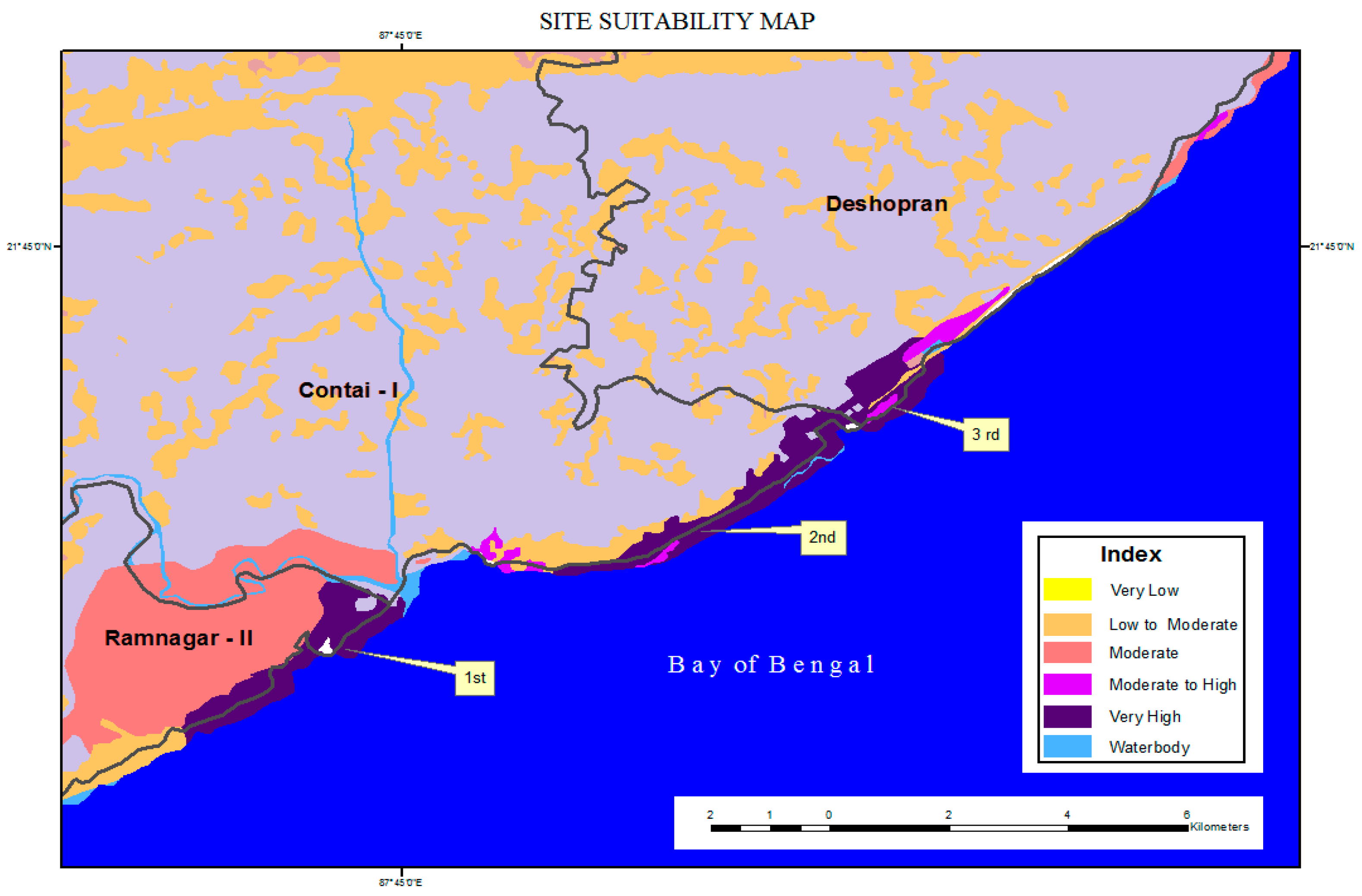
56]. It was significantly found that open space, greater beach length, a shorter beach-to-village distance, the existence of infrastructural, transport and health care facilities, and the nearest location of the town and railway station resulted in higher suitability for the geo-ecotourism sites. Based on such AHP analysis, five zones were identified based on the final score of each criterion and outlined in a suitability map (
Figure 16). In it, very high site suitability was identified along a larger beach area, while moderate to high suitability was scattered, and moderate suitability was found for the beach of the Ramnagar block. Moreover, a ranking of the beaches and corresponding village names was carried out, and it was found that the Soula and Changasuli beaches (Dakshin Purushottampur village) ranked first with the highest suitability and great potentiality, while Haripur beach (Shyam Rai Bar Jalpai, Mankarai Put, Sharad Pur, Baguran Jalpai villages) ranked second, and Junput beach (Dakshin Kadua, Biramput villages) ranked third. Therefore, it can be stated that based on the suitability analysis and ecosystem sustainability, the development of geo-ecotourism in currently unpopular coastal beaches is recommended.
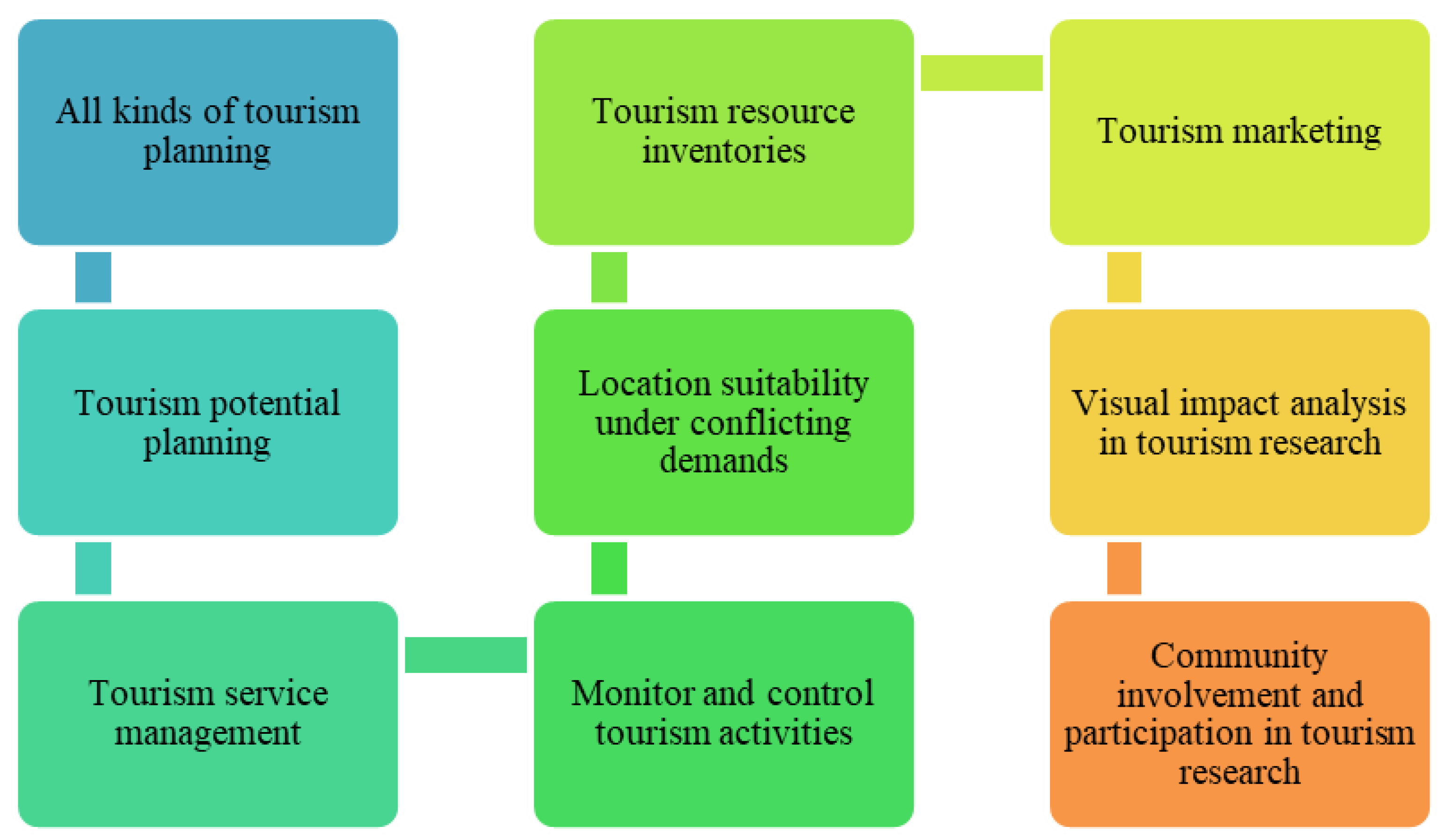
3.5. Appliance of GIS as Geospatial Techniques in Tourism Development
Geospatial techniques can be used in tourism development in diverse ways (
Figure 17), which includes tourism planning, service management, location suitability planning, demand-oriented planning, resource inventories, tourism marketing, monitoring tourism activities, community involvement, participation planning etc., and all of these can be employed for any sort of tourism. Thus, location-specific tourism, which is the key feature of geo-ecotourism, can be portrayed through this technique. Recently, tourism research and development have largely included geospatial techniques in many countries as these help countries to use, manage and distribute huge databases and produce valuable output for better and sustainable tourism. Moreover, it can coordinate government, academic and tourism sectors and tourism organizations and thus create a tourism knowledge system which finally promotes a greater vision of tourism.
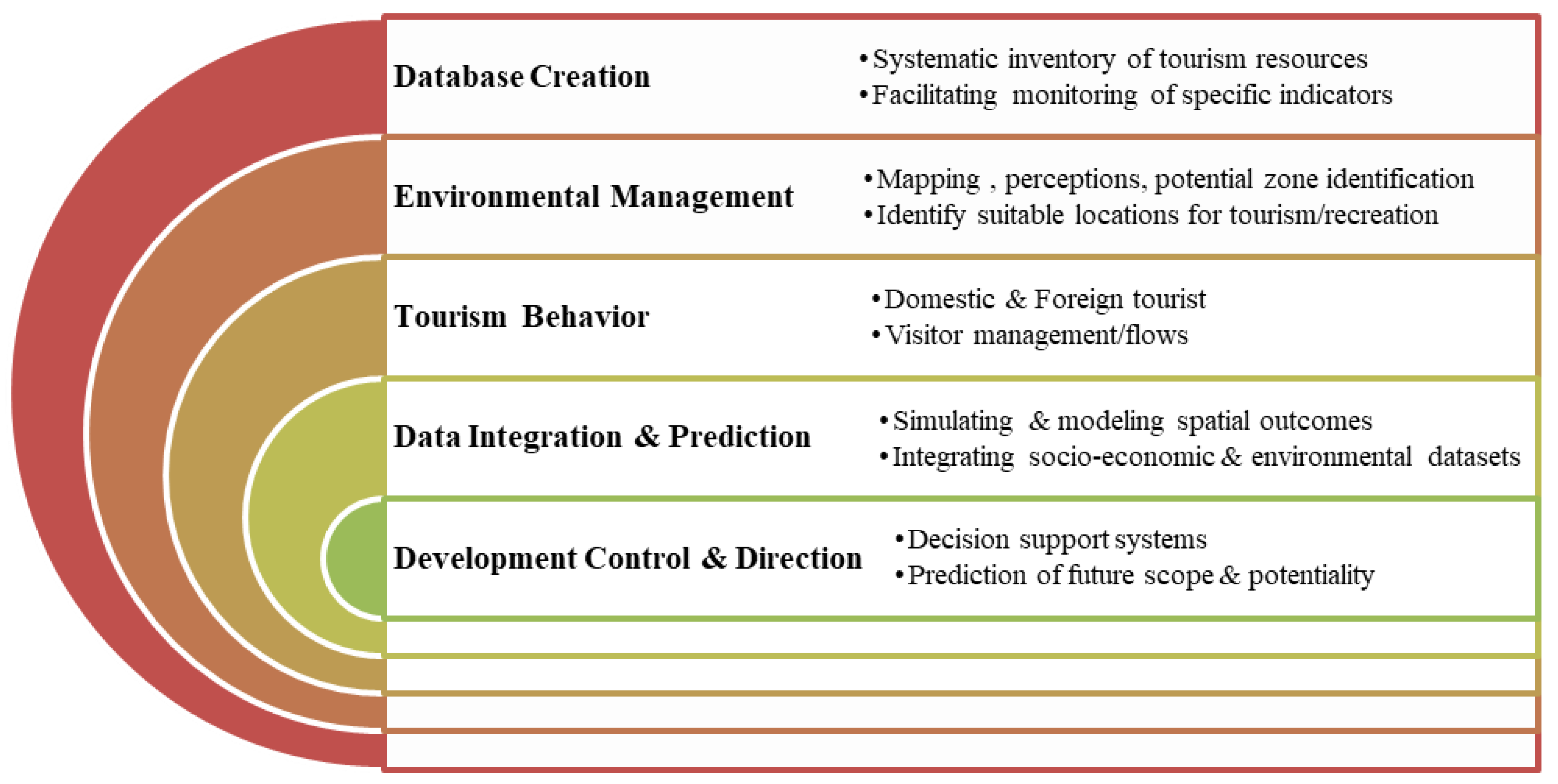
As the current study is concentrated on geo-ecotourism, a comprehensive, integrated planning and management programme has been planned to encourage sustainable geo-ecotourism development in West Bengal. This will help to promote and develop the diverse aspects of geo-ecotourism using physical, ecological, environmental, socioeconomic and cultural development of existing and potential tourist spots. This tourism has a broader prospect in utilizing re-engineering infrastructure by employing coastal, forest, agrovillage, plantation, water-based, sociocultural resource-based resources to encourage income, employment, revenue and profit generation. Moreover, there is promise in the development of systematic inventory of tourism resources, monitoring of specific indicators, domestic and foreign tourist/visitor management, simulating and modelling of spatial outcomes, integrating socioeconomic and environmental datasets, creating proper decision support systems, identification of and/or recreation in suitable locations for tourism, potential zone identification and eventually prediction of future scope and potentiality of geo-ecotourism in West Bengal (
Figure 18).
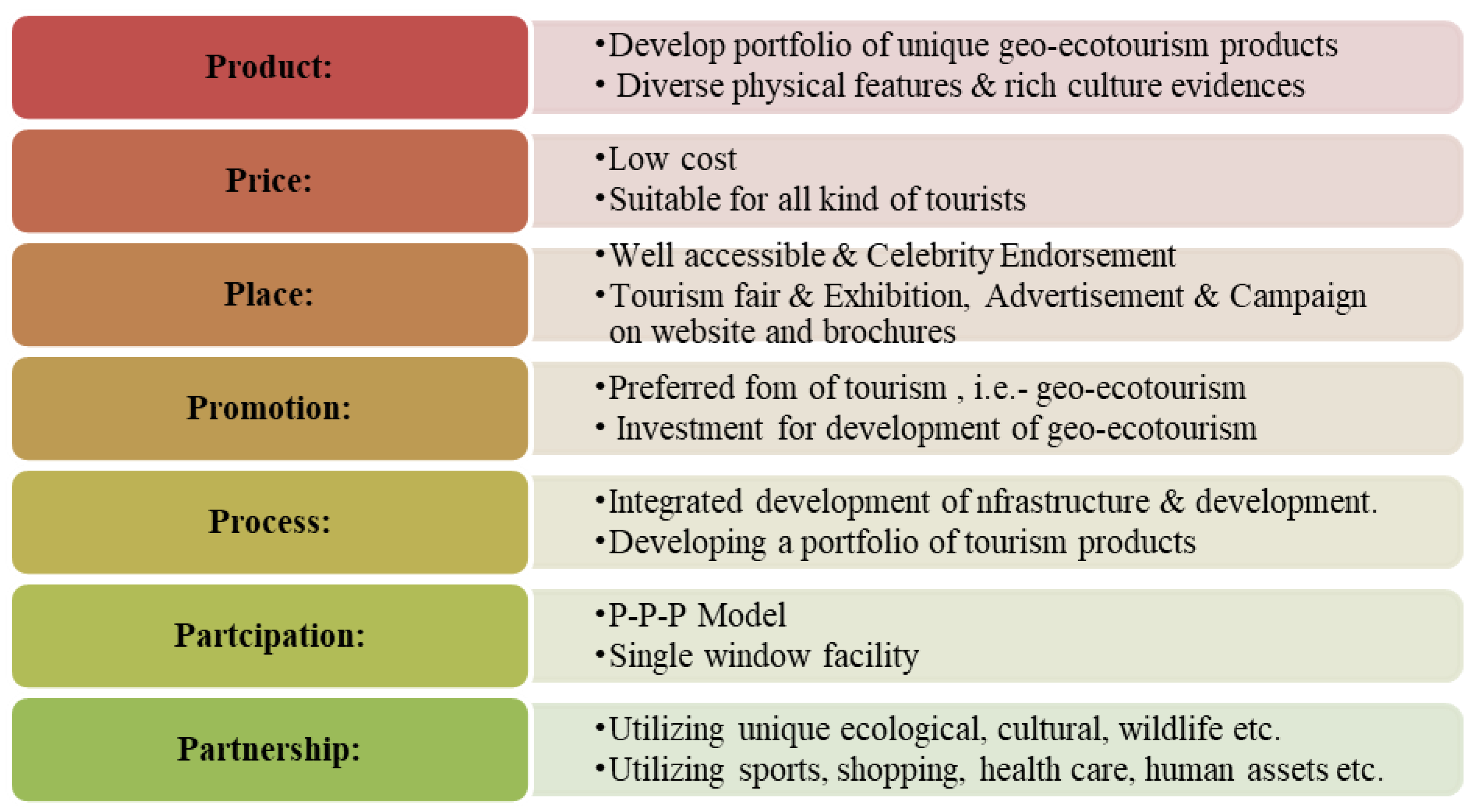
The marketing strategy of the tourism sector by the government largely depends on seven key issues (7Ps): price, place, promotion, process, participation, partnership (
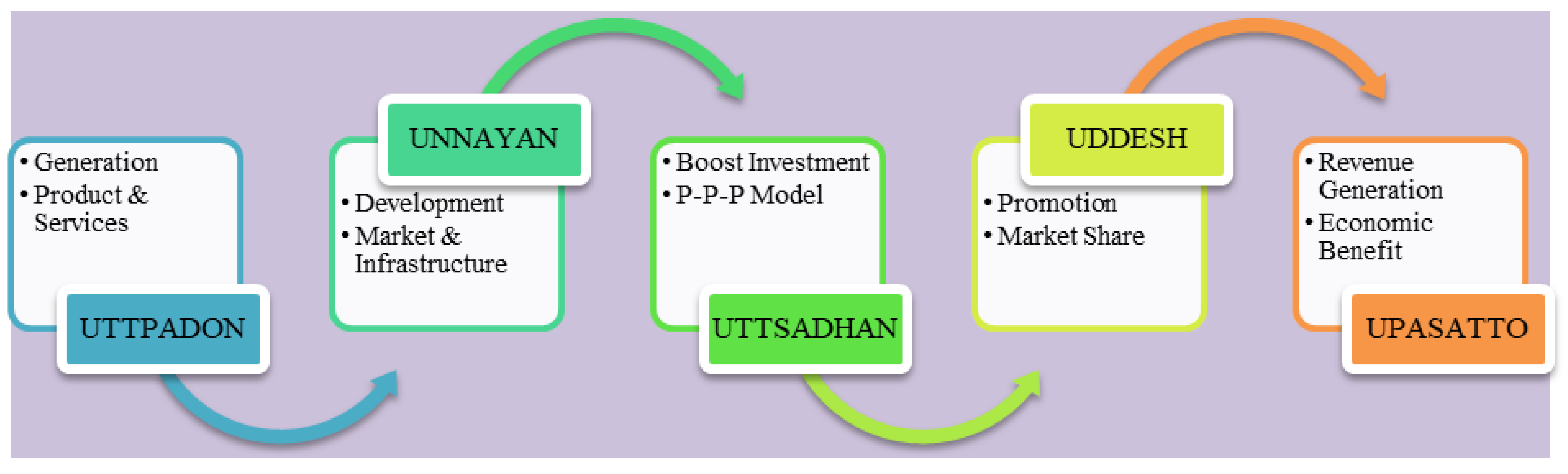
Figure 19). It includes the development of a portfolio of geo-ecotourism based on physical and cultural aspects and extends to single-window facilities and partnerships for utilizing unique aspects. The current tourism policy of West Bengal includes the 5U model in their policy planning initiatives (
Figure 20), which can also be very useful in geo-ecotourism development. It covers the production (Uttpadan) of products and services; includes development (Unnayan) of markets and infrastructure; boosts investment through the Public–Private–Partnership (P-P-P) model (Uttsadan); and induces promotion (Uddesh) and generation of revenue and economic benefits (Utsatto). This model is helpful in developing all types of tourism, but the promotional setting and advertisement campaign of government websites and brochures should be taken care of, and sustainable tourism, such as geo-ecotourism, must be highlighted in it so that all sorts of tourists can come to know the features and develop a keen interest in travelling to various destinations in West Bengal. In addition to this, the application of geospatial techniques with the analysis of remote sensing data, the inclusion of administrative information, the extension of potential tourist spots and creation of tourism facility maps and accessibility maps with the employment of GIS will help to promote geo-ecotourism planning and development.
4. Discussion
The tourism sector of West Bengal stretches from the Himalayas in the north to the Bay of Bengal in the south. The state is known for domestic, inbound, outbound and leisure tourism; and the Himalayas, Dooars Foothills, Bengal heritage, Sundarbans, coastal tracts, Kolkata and cultural and religious tourism all are very significant. The state is generally famous for its diverse tourism, which is spread across the Darjeeling, Jalpaiguri, Koch Behar, South 24 Parganas, North 24 Parganas, Nadia, Birbhum, Bankura, Purulia, Malda, Murshidabad districts and Kolkata districts, where many places attract a large volume of domestic, national and international tourists, almost throughout the entire year. More than 70 million domestic tourists and 1.5 million foreign visitors and approximately 10,000 branded hotels were recorded in 2019 [
64,
67,
68]. The state has been awarded the ‘East India Travel Award East 2016’ for the ‘Best Experimental Destination’ [
3]. This is considered as the ‘Sweetest Part of India’, and thus the state launched a new logo: ‘Experience Bengal’. Moreover, under the ‘Swedish Darshan Scheme,’ the ‘Udaypur-Digh-Sankarpur-Tajpur-Mandarmani-Bakkhali-Henry Island-Frazergaunj’ route was introduced as a new coastal circuit [
67,
68]. It signifies the importance of tourism in the state and the need for tourism development to construct more potential hotspots. Therein lies the scope of geo-ecotourism as a new form of tourism, which has already been ongoing in some states of India and is popular in other countries.
It is known to all that tourism is vital for the growth of the state’s as well as the country’s economy. Still, it is nowhere as important as famous visiting destinations such as Digha, Darjeeling, Dooars, etc., as than 15% of the region’s economy depends on the influx of annual tourists. The strategic development of geo-ecotourism in West Bengal can cater to first-timers and middle-class families and increasingly become a large travel market. A new strategic approach or method must boost this sector to cope with the situation in the post-COVID-19 era. With the combination of government and private sectors and the application of an improved management system, this sector should develop its worldwide appeal; geospatial techniques can occupy this role. This sector may concentrate on ICT usage, e-focus, a future delivery mechanism and the outcomes from the statistical analysis of travel and tourism in the pandemic situation, all of which can be used as a basis to find alternative and probable encouraging views [
74,
75]. Therefore, the current effort will shed some light on the diverse issues regarding tourism development and its economic and societal aftermath in the new normal phase of the post-COVID-19 era, and geospatial techniques can help the sector recover as well. As West Bengal is vast and diverse in terms of its features, only one region, i.e., the coastal region, was initially chosen for testing the site suitability analysis and potential mapping of geo-ecotourism by employing geospatial techniques, i.e., the AHP method.
During the application of geospatial technology, the image processing and analysis of remotely sensed data plays a pivot role, attracting advanced methods of hyperspectral image classification [
76,
77]; methods for reducing the computational complexity caused by various noise effects degradation, variability, etc., need to be applied. Moreover, some mathematical models, mixing models, etc., [
78] need to be run during the RS-data-based multicriteria decision analysis to meet various difficulties due to variability, diverse expert opinion, the nature of parameters and their regional differences. The current study used RS data from suitable times to avoid such complications and keep the diverse and complex physio-ecological and cultural features of the study region in mind; the eleven factors were considered for developing geo-ecotourism zones by employing the AHP method using geospatial technology.
The tourism sector of West Bengal is suffering from its physiocultural heterogeneity, physical isolation, inaccessibility, unplanned and haphazard growth of tourist spots, insufficient infrastructural and supra-structural facilities, information gaps, overcrowding in some spots, lack of planning for the development of new spots, lack of proper publicity and a dearth of reliable data, etc. The current attempt addressed most of these issues in a more scientific and methodological way so that the physiocultural heterogeneity coincides with the ecological diversity and developed a new terminology, ‘geo-ecotourism’, for tourists who visit the tourist spots in the state. It demonstrates how the various physical and cultural factors could be included in the geo-ecotourism zonation of West Bengal and further analysis of each zones for existing tourist spot mapping, the planned growth of possible and potential tourist spot mapping through reliable data, circuit analysis, modification of existing spots by adding attractiveness, improvement of accessibility, reducing haphazardness, concentrating of required infrastructural development, creating awareness and accordingly tourism management, which can be improved with the application of geospatial techniques and mathematical methods. The fruitful outcomes from such analysis help us to recognize suitability zones and their ranking and ensure that this could be very much beneficial to boost the tourism sector by encouraging geo-ecotourism development.
5. Conclusions
West Bengal caters to an oversized volume of domestic and foreign tourists as it shares international boundaries with three different countries, namely Nepal, Bhutan and Bangladesh, as well as its domestic boundary with the Assam, Bihar, Jharkhand and Orissa states. The state owns five national parks, fifteen wildlife sanctuaries and three tiger reserve forests, which are growing keen interest amongst tourists worldwide. Culturally, West Bengal is incredibly enriching as the state possesses a patchwork of different ethnicities; and the inhabitants of West Bengal inherited their originality and aspiration from the substantial Indian mosaic. Previously, the state was primarily dependent on mass tourism, and numerous environmental problems have emerged from this. However, in recent years, the changing patterns of tourism, behavioural changes and purchase habits of the tourists, etc., have encouraged the government to explore some other forms of tourism, such as ecotourism, geo-tourism, agro-tourism, wildlife tourism, rural tourism, etc., and geo-ecotourism will add some extra sugar in it. Hence, identifying geo-ecotourism potential will strengthen the ambition of West Bengal’s tourism potency, and the government will be able to boost the sector with ambitious plans. West Bengal possesses the potential to emerge as a frequently sought destination for geo-ecotourism for its exceptional geography, geological relics and cultural and ethnic richness. By allowing this tourism sector to flourish by developing it through pragmatic analysis with the application of geospatial techniques, the state will open itself up to more exposure, and hence, it will pave the path for economic growth through the structural conversion of the state. The influx of tourists in existing and probable geo-ecotourism spots would ensure the development of the transport and communication system for the tourists’ sake and improve the existing infrastructure.
Site suitability analysis by employing AHP method with the help of geospatial techniques in the study signifies that there is ample scope of geo-ecotourism development in the coastal tracts of West Bengal and ensures the potentiality of other tourism zones of the state. This kind of analysis helps to reduce the regional problems, ensuring employment and community participation and helps the planners and policymakers to take initiatives for sustainable and resilient tourism development in the state. The state has a huge geographical area and numerous features, and thus has ample scope of geo-ecotourism, but the current AHP investigation only focused on the coastal region; therefore, there is scope for further analysis of the other tourism regions of Bengal. It is asserted that to promote the geo-ecotourism, the regional connectivity, infrastructural sector and the economic sector of the region need to be significantly developed. Thus, the authority of the concerned section and stakeholders of West Bengal should delve into developing the tourism sector by concentrating on the growth of possible spots, discovering potential spots, carrying out attractive mapping with sufficient information and circuit analysis of different geo-ecotourism zones, modifying existing spots, creating attractiveness of unknown spots by promotion, creating awareness, improving =connectivity and accessibility, ensuring infrastructural development, constructing a build-up strategy for diverting mass tourism to the new spots, reducing haphazardness, concentrating on management involving the local community, etc. Henceforth, the development of any setting for tourism must be properly planned, and before the examination of the place for potential assessment, site suitability analysis using geospatial techniques, statistical methods and statistical methods, such as AHP, must be employed, and related research activities should be considered during budgetary provision for the sustainable and resilient development of tourism.
Author Contributions
Conceptualization, B.K.M. and A.A.; methodology, B.K.M., A.A. and R.D.; software, A.A., B.K.M. and R.D.; validation, B.K.M., P.K.M. and K.A.; formal analysis, B.K.M. and A.A.; investigation, B.K.M., P.K.M., K.A. and TB; resources, B.K.M. and A.A.; data curation, B.K.M., A.A. and P.K.M.; writing—original draft preparation, A.A., R.D. and B.K.M.; writing—review and editing, B.K.M., K.A., P.K.M., A.T. and T.B.; visualization, B.K.M., A.A., R.D., T.B. and P.K.M., supervision, K.A., P.K.M. and A.T.; project administration, K.A.; funding acquisition, K.A. and P.K.M. All authors have read and agreed to the published version of the manuscript.
Funding
Deep thanks and gratitude go out to the Researchers Supporting Project (RSP-2021/351), King Saud University, Riyadh, Saudi Arabia, for funding the research article.
Institutional Review Board Statement
Not applicable.
Informed Consent Statement
Not applicable.
Data Availability Statement
Not applicable.
Conflicts of Interest
The authors declare that there is no conflict of interest.
References
- Koizumi, T.; Chakraborty, A. Geo-ecotourism and environmental conservation education: Insights from Japan. GeoJournal 2016, 81, 737–750. [Google Scholar] [CrossRef]
- World Travel & Tourism Council (WTTC). 2017. Available online: https://skift.com/wp-content/uploads/2017/06/WTTC-June-2017.pdf (accessed on 19 July 2021).
- Ministry of Tourism, GOI. India Tourism Statistics, New Delhi. 2019. Available online: http://tourism.gov.in/sites/default/files/Other/India%20Tourism%20Statistics%202019.pdf (accessed on 25 September 2021).
- Buckley, R. A framework for ecotourism. Ann. Tour. Res. 1994, 21, 661–665. [Google Scholar] [CrossRef]
- Elliott-White, M.P.; Finn, M. Growing in sophistication: The application of geographic information systems in post-modern tourism marketing. J. Travel Tour. Mark. 1997, 7, 65–84. [Google Scholar] [CrossRef]
- Tewodros, K. Geospatial Approach for Ecotourism Development: A Case of Bale Mountain National Park. Addis Ababa University. 2010. Available online: http://etd.aau.edu.et/handle/123456789/789 (accessed on 25 September 2021).
- Abed, M.H.; Monavari, M.; Karbasi, A.; Farshchi, P.; Abedi, Z. Site selection using Analytical Hierarchy Process by geographical information system for sustainable coastal tourism. In Proceedings of the International Conference on Environmental and Agriculture, Engineering, Chengdu, China, 29–31 July 2011; Volume 15, pp. 120–124. [Google Scholar]
- Bunruamkaew, K.; Murayama, Y. Site suitability evaluation for ecotourism using GIS & AHP: A case study of Surat Thani province, Thailand. Proced. Soc Behav. Sci. 2011, 2, 269–278. [Google Scholar]
- Reihanian, A.; Noor Zalina Binti, M.; Kahrom, E.; Hin, T.W. Sustainable tourism development strategy by SWOT analysis: Boujagh National Park, Iran. Tour. Manag. Perspect. 2012, 4, 223–228. [Google Scholar] [CrossRef]
- Dowling, R.K. Global Geotourism—An emerging form of sustainable tourism. Czech J. Tour. 2013, 2, 59–79. [Google Scholar] [CrossRef] [Green Version]
- Ahmadi, M.; Darabkhani, M.F.; Ghanavati, E. A GIS-based Multi-criteria Decision-making Approach to Identify Site Attraction for Ecotourism Development in Ilam Province, Iran. J. Qual. Assur. Hosp. Tour. 2014, 12, 243–268. [Google Scholar] [CrossRef]
- Mihret, G.; Yohannes, L. Site suitability evaluation of ecotourism potentials or sustainable natural resource management and community based ecotourism development: The case of Bench Maji zone, southwestern part of Ethiopia. J. Arts Humanit. Soc. Sci. 2015, 3, 1368–1383. [Google Scholar]
- Suryabhagavan, K.V.; Tamirat, H.; Balakrishinan, M. Multi-criteria evaluation in identification of potential ecotourism sites in Hawassa town and its surroundings, Ethiopia. J. Geomat. 2015, 1, 86–92. [Google Scholar]
- Pita, A.B.C.; Cahyono, A. Development of Landscape Architecture through Geo-eco-tourism in Tropical Karst Area to Avoid Extractive Cement Industry for Dignified and Sustainable Environment and Life. IOP Conf. Ser. Earth Environ. Sci. 2017, 83, 012028. [Google Scholar] [CrossRef] [Green Version]
- Palmer, N.J.; Chuamuangphan, N. Governance and local participation in ecotourism: Community-level ecotourism stakeholders in Chiang Rai province, Thailand. J. Ecotourism 2018, 17, 320–337. [Google Scholar] [CrossRef]
- Taye, B. Using Geospatial Techniques in the Selection of Potential Ecotourism Sites in Menz-geramidir District, Ethiopia. Ghana J. Geogr. 2019, 11, 201–227. [Google Scholar] [CrossRef]
- Zarghi, A.H.; Bidkhori, A.; Hosseini, S.M. Site Suitability Evaluation for Ecotourism Using GIS & MCDM: A Case Study of Bazangan Lake Watershed, Iran. J. Nov. Appl Sci. 2019, 8, 170–181. Available online: http://jnasci.org/wp-content/uploads/2019/12/JNASCI-2019-170-181.pdf (accessed on 15 October 2021).
- Tomic, N.; Markovic, S.B.; Antic, A.; Tesic, D. Exploring the potential for geotourism development in the Danube region of Serbia. Int. J. Geoheritage Parks 2020, 8, 123–139. [Google Scholar] [CrossRef]
- Ambecha, A.B.; Melka, G.A.; Gemeda, D.O. Ecotourism site suitability evaluation using geospatial technologies: A case of Andiracha district, Ethiopia. Spat. Inf. Res. 2020, 28, 559–568. [Google Scholar] [CrossRef]
- Guerrero, J.V.R.; Gomes, A.A.T.; de Lollo, J.A.; Moschini, L.E. Mapping Potential Zones for Ecotourism Ecosystem Services as a Tool to Promote Landscape Resilience and Development in a Brazilian Municipality. Sustainability 2020, 12, 10345. [Google Scholar] [CrossRef]
- Strba, L.; Kolackovská, J.; Kudelas, D.; Kršák, B.; Sidor, K. Geoheritage and Geotourism Contribution to Tourism Development in Protected Areas of Slovakia—Theoretical Considerations. Sustainability 2020, 12, 2979. [Google Scholar] [CrossRef] [Green Version]
- Chlachula, J.; Zhensikbayeva, N.Z.; Yegorina, A.V.; Kabdrakhmanova, N.K.; Czerniawska, J.; Kumarbekuly, S. Territorial Assessment of the East Kazakhstan Geo/Ecotourism: Sustainable Travel Prospects in the Southern Altai Area. Geosciences 2021, 11, 156. [Google Scholar] [CrossRef]
- Maharana, I.; Rai, S.C.; Sharma, E. Valuing ecotourism in a sacred lake of the Sikkim Himalaya, India. Environ. Conserv. 2000, 27, 269–277. [Google Scholar] [CrossRef]
- Das, S. Ecotourism, sustainable development and the Indian state. Econ. Political Wkly. 2011, 46, 60–67. [Google Scholar]
- Vinodan, A.; Manalel, J. Local economic benefits of ecotourism: A case study on Parambikulan Tiger Reserve in Kerala, India. South Asian J. Tour. Herit. 2011, 4, 93–109. [Google Scholar]
- Kala, C.P. Ecotourism and sustainable development of mountain communities: A study of Dhanolti Ecopark in Uttarakhand state of India. Appl. Ecol. Environ. Sci. 2013, 1, 98–103. [Google Scholar] [CrossRef]
- Ecotourism Society of India (ESI). Ecotourism and Environment Handbook: A Ready Reckoner for the Tourism Industry. 2014, pp. 1–292. Available online: http://www.ecotourismsocietyofindia.org/file/ESOI-HANDBOOK-2014_kuoni.pdf (accessed on 15 October 2021).
- Kumari, S.; Behera, M.D.; Tewari, H.R. Identification of potential ecotourism sites in West District, Sikkim using geospatial tools. Trop. Ecol. 2010, 51, 75–85. [Google Scholar]
- Chand, S.; Singh, S.; Parappurathu, S.; Roy, S.D.; Kumar, A. Explaining the status and scope of ecotourism development for livelihood security: Andaman and Nicobar Islands, India. Int. J. Sustain. Dev. World Ecol. 2015, 22, 335–345. [Google Scholar] [CrossRef]
- Das, M.; Chatterjee, B. Ecotourism and empowerment: A case analysis of Bhitarkanika Wildlife Sanctuary, Odisha, India. IIM Kozhikode Soc. Manag. Rev. 2015, 4, 136–145. [Google Scholar] [CrossRef]
- Bhalla, P.; Coghlan, A.; Bhattacharya, P. Homestays’ contribution to community-based ecotourism in the Himalayan region of India. Tour. Recreat. Res. 2016, 41, 213–228. [Google Scholar] [CrossRef]
- Goodwin, R.D.; Chaudhary, S.K. Eco-tourism dimensions and directions in India: An empirical study of Andhra Pradesh. J. Commer. Manag. Thought 2017, 8, 436–451. [Google Scholar] [CrossRef]
- Grover, A.K.; Mahanta, B.N. Geotourism potential in Arunachal Pradesh—A preliminary appraisal. Indian J. Geosci. 2018, 72, 345–360. [Google Scholar]
- Hameed, B.; Khalid, A. Impact of Ecotourism in Ensuring the Sustainable Development of Tourism Industry in India. Int. J. Recent Res. Asp. 2018, 5. Available online: https://www.ijrra.net/Vol5issue2/IJRRA-05-02-11.pdf (accessed on 22 October 2021).
- Karunakaran, N. Ecotourism Development and its Economic Impacts on Local Population in India. Int. J. Adv. Multidiscip. Sci. Res. 2018, 1, 17–20. [Google Scholar] [CrossRef]
- Poyyamoli, G. Ecotourism policy in India: Rhetoric and reality. Grassroots J. Nat. Resour. 2018, 1, 46–61. [Google Scholar] [CrossRef]
- Shamnas, S.; Aishwarya, G.S.; Arun, K. GIS: A Tool for Eco-Tourism Site Selection in South Kerala. Int. J. Pure Appl. Math. 2018, 118, 4105–4111. [Google Scholar]
- Cabral, C.; Dhar, R.L. Ecotourism research in India: From an integrative literature review to a future research framework. J. Ecotourism 2020, 19, 23–49. [Google Scholar] [CrossRef]
- Ranjith, M. To Examine the Potential and Scope of Ecotourism in Kerala with a Special Focus on Tourists to Ecotourism Destinations in Trivandrum. J. Tourism Hospit. 2020, 9, 433. [Google Scholar] [CrossRef]
- Sachin, C.P.; Niharranjan, M. Ecotourism industry in India: A review of current practices and prospects. Anatolia 2020, 32, 289–302. [Google Scholar] [CrossRef]
- Sati, V.P. Sustainable Tourism Development: Constraints and Prospects. In Sustainable Tourism Development in the Himalaya: Constraints and Prospects; Springer: Cham, Switzerland, 2020; pp. 133–139. [Google Scholar] [CrossRef]
- Karmakar, M. Ecotourism and Its impact on the regional economy—A study of North Bengal (India). Tour. Int. Mutidisciplinary J. Tour. 2011, 6, 251–270. [Google Scholar]
- Banerjee, M. Eco-tourism in Sunderbans—A life line for local people and the ecology. Int. J. Sci. Res. 2014, 3, 25–202. [Google Scholar]
- Ahamed, M. Cultural Heritage Tourism—An Analysis with Special Reference to West Bengal (A State of India). Int. J. Recent Trends Bus. Tour. 2017, 1, 55–62. [Google Scholar]
- Bhaya, S.; Chakrabarty, A. A GIS Based Ecotourism Infrastructure Planning for Promotion of Tourism in Jungle Mahal of West Bengal. J. Remote Sens. GIS 2016, 5, 181. [Google Scholar] [CrossRef]
- Mondal, S. West Bengal -A Tourist Destination Comparative Analysis of Bengal Tourism Business Method with Kerala & Gujarat. Arab. J. Bus Manag. Rev. 2016, 6, 245. [Google Scholar] [CrossRef]
- Chakrabarty, P.; Mandal, T. (Eds.) Tourism and Sustainability: A Geographical Study in the Rarh Region of West Bengal; Anjan Publisher: Kolkata, India, 2018. [Google Scholar]
- Chakrabarty, P.; Mandal, R. Geoarchaeo sites for geotourism: A spatial analysis for Rarh Bengal in India. Geo J. Tour. Geosites 2019, 25, 543–554. [Google Scholar] [CrossRef]
- Ghosh, P.; Ghosh, A. Is ecotourism a panacea? Political ecology perspectives from the Sundarban Biosphere Reserve, India. GeoJournal 2019, 84, 345–366. [Google Scholar] [CrossRef]
- Mahato, M.K.; Jana, N.C. Exploring the potential for development of Geotourism in Rarh Bengal, Eastern India using M-GAM. Int. J. Geoheritage Parks 2020, 9, 313–322. [Google Scholar] [CrossRef]
- Mahato, S. Travel Route Planning for Eco-Tourists of Jungle Mahals of West Bengal. Sambodhi J. 2021, 46, 352–361. [Google Scholar]
- Ghosh, A.; Mukhopadhyay, S.; Chatterjee, S. Assessment of geoheritage and prospects of geotourism: An approach to geoconservation of important geological and geomorphological sites of Puruliya district, West Bengal, India. Int. J. Geoheritage Parks 2021, 9, 264–283. [Google Scholar] [CrossRef]
- Bhushan, N.; Rai, K. Strategic Decision Making: Applying the Analytic Hierarchy Process; Springer Science & Business Media: Berlin/Heidelberg, Germany, 2007. [Google Scholar]
- Mahdavi, A.; Niknejad, M. Site suitability evaluation for ecotourism using MCDM methods and GIS: Case study-Lorestan province, Iran. J. Biodivers. Environ. Sci. 2014, 4, 425–437. [Google Scholar]
- Çetinkaya, C.; Kabak, M.; Erbaş, M.; Özceylan, E. Evaluation of ecotourism sites: A GIS-based multi-criteria decision analysis. Kybernetes 2018, 47, 1664–1686. [Google Scholar] [CrossRef]
- Datta, K. Application of SWOT-TOWS Matrix and Analytical Hierarchy Process (AHP) in the Formulation of Geo-conservation and Geotourism Development Strategies for Mama Bhagne Pahar: An Important Geomorphosite in West Bengal, India. Geoheritage 2020, 12, 45. [Google Scholar] [CrossRef]
- Bahaire, M.; White, E. The Application of Geographical Information Systems (GIS) in Sustainable Tourism Planning: A Review. J. Sustain. Tour. 1999, 7, 159–174. [Google Scholar] [CrossRef]
- Farsari, Y.; Prastacos, P. GIS applications in the planning and management of tourism. In A Companion to Tourism; Wiley-Blackwell: Oxford, UK, 2004; pp. 596–607. [Google Scholar]
- Julia, C.H.; Milne, S. Participatory Approaches and Geographical Information Systems (PAGIS) in Tourism Planning. Tour. Geogr. 2005, 7, 272–289. [Google Scholar]
- Fung, T.; Wong, F.K.K. Ecotourism planning using multiple criteria evaluation with GIS. Geocarto. Int. 2007, 22, 87–105. [Google Scholar] [CrossRef]
- Widaningrum, D.L. A GIS-based approach for information management in ecotourism region. Procedia. Comput. Sci. 2015, 15, 511–518. [Google Scholar] [CrossRef] [Green Version]
- Samanta, S.; Baitalik, A. Potential Site Selection for Eco-Tourism: A Case Study of Four Blocks in Bankura District Using Remote Sensing and GIS Technology, West Bengal. Int. J. Adv. Res. 2015, 3, 978–989. [Google Scholar]
- Census of India. Government of India. 2011. Available online: https://censusindia.gov.in/2011-common/censusdata2011.html (accessed on 2 November 2021).
- Economic Review, Government of West Bengal. 2020. Available online: http://www.wbpspm.gov.in/publications/Economic%20Review (accessed on 2 November 2021).
- Saaty, T. The Analytic Hierarchy Process; McGraw-Hill: New York, NY, USA, 1980; p. 287. [Google Scholar]
- Statistical Abstract, Government of West Bengal. 2015. Available online: http://www.wbpspm.gov.in/publications/Statistical%20Abstract (accessed on 2 November 2021).
- Department of Tourism, Government of West Bengal. (n.d.). Available online: http://beautifulbengal.com/west-bengal-tourism-department.html (accessed on 7 November 2021).
- Department of Tourism, Government of West Bengal. (n.d.). Available online: https://www.wbtourismgov.in/ (accessed on 7 November 2021).
- Chakraborty, S.K. Coastal environment of Midnapore, West Bengal: Potential threats and management. J. Coast. Environ. 2010, 1, 27–40. [Google Scholar]
- Mitra, S.S.; Santra, A.; Mitra, D. Change detection analysis of the shoreline using Toposheet and Satellite Image: A case study of the coastal stretch of Mandarmani-Shankarpur, West Bengal, India. Int. J. Geomat. Geosci. 2013, 3, 425. [Google Scholar]
- Mandal, M.; Dandapath, P.K. Digha Sankarpur littoral tract a geographical case study. Int. J. Humanit. Soc. Sci. Invent. 2013, 2, 46–54. [Google Scholar]
- Banerjee, U.K.; Kumari, S.; Paul, S.K.; Sudhakar, S. Remote Sensing and GIS Based Ecotourism Planning: A Case Study for Western Midnapore, West Bengal, India; ESRI: Noida, India, 2002. [Google Scholar]
- Dandapath, P.K.; Mondal, M. Urbanisation and its impact on coastal eco-tourism in West Bengal. Int. J. Sci. Res. 2013, 2, 114–119. [Google Scholar]
- Kreiner, N.C.; Ram, Y. National tourism strategies during the COVID-19 pandemic. Ann. Tour. Res. 2020, 89, 130076. [Google Scholar] [CrossRef]
- Sigala, M. Tourism and COVID-19: Impacts and implications for advancing and resetting industry and research. J. Bus. Res. 2020, 117, 312–321. [Google Scholar] [CrossRef]
- Hong, D.; Gao, L.; Yao, J.; Zhang, B.; Plaza, A.; Chanussot, J. Graph Convolution Network for Hyperspectral Image Classification. IEEE Trans. Geosci. Remote Sens. 2020, 59, 5966–5978. [Google Scholar] [CrossRef]
- Hong, D.; Han, Z.; Gao, L.; Yao, J.; Zhang, B.; Plaza, A.; Chanussot, J. SpectralFormer: Rethinking Hyperspectral Image Classification with Transformer. IEEE Trans. Geosci. Remote Sens. 2021. [Google Scholar] [CrossRef]
- Hong, D.; Yokoya, N.; Chanussot, J.; Zhu, X.X. An Augmented linear Mixing Model to Address Spectral Variability for Hyperspectral Unmixing. IEEE Trans. Image Processing 2018, 28, 1923–1938. [Google Scholar] [CrossRef] [Green Version]
Figure 1.
Location map of the study area.
Figure 1.
Location map of the study area.
Figure 2.
Structural framework of the study.
Figure 2.
Structural framework of the study.
Figure 3.
Trend of tourist arrival in West Bengal.
Figure 3.
Trend of tourist arrival in West Bengal.
Figure 4.
Domestic tourist arrival in West Bengal.
Figure 4.
Domestic tourist arrival in West Bengal.
Figure 5.
Foreign tourist arrival in West Bengal.
Figure 5.
Foreign tourist arrival in West Bengal.
Figure 6.
Importance of suitability of factors for geo-ecotourism.
Figure 6.
Importance of suitability of factors for geo-ecotourism.
Figure 7.
Physiographic divisions of West Bengal.
Figure 7.
Physiographic divisions of West Bengal.
Figure 8.
Land Use/Land Cover of West Bengal.
Figure 8.
Land Use/Land Cover of West Bengal.
Figure 9.
Geo-ecotourism zones in West Bengal.
Figure 9.
Geo-ecotourism zones in West Bengal.
Figure 10.
District-wise major tourist spots.
Figure 10.
District-wise major tourist spots.
Figure 11.
Geo-ecotourism spots of Himalayan hills & foothill regions.
Figure 11.
Geo-ecotourism spots of Himalayan hills & foothill regions.
Figure 12.
Geo-ecotourism spots of Rarh region.
Figure 12.
Geo-ecotourism spots of Rarh region.
Figure 13.
Geo-ecotourism spots of Coastal region.
Figure 13.
Geo-ecotourism spots of Coastal region.
Figure 14.
Geo-ecotourism spots of Sundarbans region.
Figure 14.
Geo-ecotourism spots of Sundarbans region.
Figure 15.
Coastal region of West Bengal with the beaches of tourist interest.
Figure 15.
Coastal region of West Bengal with the beaches of tourist interest.
Figure 16.
Site Suitability of Coastal region.
Figure 16.
Site Suitability of Coastal region.
Figure 17.
Application of Geospatial techniques in tourism development.
Figure 17.
Application of Geospatial techniques in tourism development.
Figure 18.
Applications of geospatial techniques in common tourism-related issues.
Figure 18.
Applications of geospatial techniques in common tourism-related issues.
Figure 19.
Marketing strategy for tourism development in West Bengal.
Figure 19.
Marketing strategy for tourism development in West Bengal.
Figure 20.
The 5U model for Policy Planning Initiative of West Bengal Tourism Development. (Prepared by the authors on the basis of the objectives of tourism policy of West Bengal).
Figure 20.
The 5U model for Policy Planning Initiative of West Bengal Tourism Development. (Prepared by the authors on the basis of the objectives of tourism policy of West Bengal).
Table 1.
Different types of datasets used in the study.
Table 1.
Different types of datasets used in the study.
| Data | Sources |
|---|
| Topographical Sheets (R.F.-1:50,000) | Survey of India, 1968–1969 |
| Landsat ETM+ Satellite Image | Google Earth, USGS, 2020 |
| Physiography Map | Shuttle Radar Topography Mission Data, 2020 |
| Land Use Land Cover (LULC) Map | Bhuvan (http://bhuvan.nrsc.gov.in, 2017, accessed on 27 November 2021) |
| Socioeconomic Data | Census of India, Economic Review, Statistical Abstract, 2011 |
Table 2.
Saaty’s Scale of relative importance.
Table 2.
Saaty’s Scale of relative importance.
| Scale | Numerical Rating | Reciprocal |
|---|
| Extremely Preferred | 9 | 1/9 |
| Very Strong to Extremely | 8 | 1/8 |
| Very Strongly Preferred | 7 | 1/7 |
| Strong to Very Strongly | 6 | 1/6 |
| Strongly Preferred | 5 | 1/5 |
| Moderately to Strongly | 4 | 1/4 |
| Moderately Preferred | 3 | 1/3 |
| Equally to Moderately | 2 | 1/2 |
| Equally Preferred | 1 | 1 |
Table 3.
Analyzing the suitability factors for geo-ecotourism in West Bengal by AHP.
Table 3.
Analyzing the suitability factors for geo-ecotourism in West Bengal by AHP.
| | R | S | D | F | P | T | I | H | RD | SB | L | Weightage |
|---|
| Relief (R) | 1.00 | 2.00 | 2.00 | 2.00 | 3.00 | 2.00 | 2.00 | 3.00 | 2.00 | 2.00 | 2.00 | 0.1484 |
| Slope (S) | 0.50 | 1.00 | 2.00 | 2.00 | 3.00 | 2.00 | 2.00 | 3.00 | 2.00 | 2.00 | 2.00 | 0.1387 |
| Drainage (D) | 0.50 | 0.33 | 1.00 | 2.00 | 3.00 | 2.00 | 2.00 | 3.00 | 2.00 | 2.00 | 2.00 | 0.1279 |
| Forest (F) | 0.50 | 0.50 | 0.50 | 1.00 | 3.00 | 2.00 | 2.00 | 3.00 | 2.00 | 2.00 | 2.00 | 0.1194 |
| Population density (P) | 0.33 | 0.33 | 0.33 | 0.33 | 1.00 | 2.00 | 2.00 | 2.00 | 2.00 | 2.00 | 2.00 | 0.0925 |
| Tourist spots (T) | 0.50 | 0.50 | 0.50 | 0.50 | 0.50 | 1.00 | 2.00 | 2.00 | 2.00 | 2.00 | 2.00 | 0.0871 |
| Infrastructure (I) | 0.50 | 0.50 | 0.50 | 0.50 | 0.50 | 0.50 | 1.00 | 2.00 | 2.00 | 2.00 | 2.00 | 0.0774 |
| Health (H) | 0.33 | 0.33 | 0.33 | 0.33 | 0.50 | 0.50 | 0.50 | 1.00 | 2.00 | 2.00 | 2.00 | 0.0634 |
| Road density (RD) | 0.50 | 0.50 | 0.50 | 0.50 | 0.50 | 0.50 | 0.50 | 0.50 | 1.00 | 2.00 | 2.00 | 0.0580 |
| Scenic beauty (SB) | 0.50 | 0.50 | 0.50 | 0.50 | 0.50 | 0.50 | 0.50 | 0.50 | 0.50 | 1.00 | 2.00 | 0.0484 |
| LULC (L) | 0.50 | 0.50 | 0.50 | 0.50 | 0.50 | 0.50 | 0.50 | 0.50 | 0.50 | 0.50 | 1.00 | 0.0387 |
Table 4.
Consistency Index (CI) and Consistency Ratio (CR) for validation of AHP.
Table 4.
Consistency Index (CI) and Consistency Ratio (CR) for validation of AHP.
| Lamda Max | Consistency Index (CI) | Random Consistency Index (RI) | Consistency Ratio (CR) | Remarks |
|---|
| 25.83 | 0.216718 | N = 11, RI = 1.51 | 0.14 | The decision is reliable and significant |
| Publisher’s Note: MDPI stays neutral with regard to jurisdictional claims in published maps and institutional affiliations. |
© 2022 by the authors. Licensee MDPI, Basel, Switzerland. This article is an open access article distributed under the terms and conditions of the Creative Commons Attribution (CC BY) license (https://creativecommons.org/licenses/by/4.0/).


 ,
, 


