Article

Basin-Scale Approach to Integration of Agro- and Hydroecological Monitoring for Sustainable Environmental Management: A Case Study of Belgorod Oblast, European Russia

1
Federal and Regional Centre for Aerospace and Ground Monitoring of Objects and Natural Resources, Belgorod State National Research University, 308015 Belgorod, Russia
2
Institute of Geology and Petroleum Technologies, Kazan Federal University, 420008 Kazan, Russia
3
Department of Agricultural Complex and Environmental Restoration of the Belgorod Oblast, 308000 Belgorod, Russia
*
Author to whom correspondence should be addressed.
Sustainability 2022, 14(2), 927; https://doi.org/10.3390/su14020927
Submission received: 10 December 2021 / Revised: 8 January 2022 / Accepted: 11 January 2022 / Published: 14 January 2022
(This article belongs to the Special Issue Water Resources Governance for a Sustainable Future)

Abstract

:
The quantitative and qualitative depletion of water resources (both surface and groundwater) is closely related to the need to protect soils against degradation, rationalization of land use, and regulation of surface water runoff within the watershed area. Belgorod Oblast (27,100 km2), one of the administrative regions of European Russia, was chosen as the study area. It is characterized by a high activity of soil erosion (the share of eroded soils is about 48% of the total area of arable land). The development phase of the River Basin Environmental Management Projects (217 river basins from the fourth to seventh order) allowed for the proceeding of the development of an integrated monitoring system for river systems and river basin systems. The methods used to establish a geoecological network for regional monitoring include the selection and application of GIS techniques to quantify the main indicators of ecological state and predisposition of river basins to soil erosion (the share of cropland and forestland, the share of the south-oriented slopes, soil erodibility, Slope Length and Steepness (LS) factor, erosion index of precipitation, and the river network density) and the method of a hierarchical classification of cluster analysis for the grouping of river basins. An approach considering the typology of river basins is also used to expand the regional network of hydrological gauging stations to rationalize the national hydrological monitoring network. By establishing 16 additional gauging stations on rivers from the fourth to seventh order, this approach allows for an increase in the area of hydro-agroecological monitoring by 1.26 times (i.e., up to 77.5% of the total area of Belgorod Oblast). Some integrated indicators of agroecological (on the watershed surface) and hydroecological (in river water flow) monitoring are proposed to improve basin environmental management projects. Six-year monitoring showed the effectiveness of water quality control measures on an example of a decrease in the concentrations of five major pollutants in river waters.

Graphical Abstract

1. Introduction

The river basin as an integral natural formation, which is a meeting point for flows of substances and energy, is to be considered from the perspective of operational territorial units of integrated environmental monitoring. In recent years, sustainable land use has been justified not for individual economic areas but within the boundaries of complete basins that integrate separate subsystems of landscape architecture according to common features of hydrofunctioning [1,2,3,4,5,6,7,8,9]. Environmental management within one hydrographic basin takes into account many factors. It is necessary to assess, on the one hand, available water resources such as precipitation, surface runoff, groundwater reserves, and return water, and on the other hand, the water needs of various sectors of the economy such as municipal water supply, irrigation, industry, hydropower production, recreation, shipping, fishing, etc. [10]. Assessment of the anthropogenic pressure on basin geosystems includes population density and infrastructure, industrial, and agricultural indicators in various forms [11,12,13]. The characteristics of river basins used in different countries are different. These include abiotic parameters (land use/land cover, soil texture, depth to bedrock, depth to the water table, recent precipitation area, total stream length, watershed shape, topographic complexity, mean elevation, mean slope [14]), as well as biotic indicators [15]. In addition to these indicators, social pressure and recovery potential were considered for the entire land area within certain administrative boundaries [16].
River basins in regions of intensive agricultural development require supporting measures and environmental management, restoring the ecological balance of the territory, primarily through optimization of the land use structure. The effectiveness of approaches to a comprehensive assessment of the ecological and economic balance of river basins and the assessment of natural protection, absolute and relative tension of the ecological and economic state of territories in various environmental conditions is shown [17,18,19,20]. Understanding the importance of agroforestry for modern agricultural landscapes has led to the formation of sustainable and durable agroforestry systems based on a combination of agricultural and landscape-ecological ideologies [4,21]. It was previously suggested [22,23] that small watersheds and river ecosystems should be used as key monitoring sites for land monitoring at various levels.
To prevent qualitative depletion of water resources, any environmental policy should focus on the priority of clean water as the basis for the maintenance of public health and key life-sustaining conditions (stable functioning of water and land ecosystems, efficiency and quality of agricultural products, reproduction of fish resources, recreational and aesthetic potential of water bodies) [24,25,26]. Along with hydrological and hydroecological monitoring of water bodies in specific places and at the outlet, it is no less essential to monitor natural and economic situations, particularly agroenvironmental parameters within river basins [27,28,29,30,31,32,33,34]. Therefore, a set of water quality indicators with a unique range of values should be produced for different river basins with due account for specifics of economic management and physiographical, geological, topographical, and climatic conditions [35].
Hydroecological monitoring for river basins amid increasing restrictions on the amount of water (both surface and groundwater) aims to assess the state of water resources and detect their changes over time. It includes a wide range of evaluation indicators: surface and underground runoff, qualitative indicators of the state of water resources, changes in the configuration of rivers and water reservoirs, usage mode for water protection zones, and others.
The order structure of river basins determines the hierarchy of territorial monitoring levels [35,36,37]. The eighth-order and higher river basins can be used for the national level. The seventh-order basins are for the country’s regional level, and the sixth- and fifth-order basins are for the municipal level. River basins of the fourth order and lower should be considered as a set of positional and dynamic relations between elementary natural complexes [38]. Indicators of the state of any basin reflect the entire state of the previous hierarchical level of river basin organization. Structurally, such an organization of river basins of different orders [39] allows judging of the universal nature of specific processes manifested in their subordinate hierarchical levels. All this can be considered a conceptual framework for monitoring based on river basin principles.
Geographic Information Systems (GIS) have become widely used because inventory and spatial analysis of water and land resources in river basins require obtaining, storing, and simultaneously processing a wide range of quantitative data and visualizing spatial data [40,41,42,43,44,45]. Multivariate statistics and neural network technologies are promising for a comprehensive analysis, assessment of series heterogeneity, determination of spatiotemporal patterns of formation, and synchronization of the dynamics of river water flow and soil erosion [46,47,48,49,50,51]. In addition, using multivariate techniques can be implemented to guide optimization projects for the surface water quality network monitoring in the river basins [52,53,54,55]. The methodology for assessing the state of agricultural landscapes is based on remote sensing data and multivariate cartographic analysis using geoinformation technologies [56]. This provides qualitatively new cartographic and geographic information support for experimental and design work on the anti-erosion arrangement of agricultural landscapes based on electronic thematic maps and landscape models [22,57,58].
Branched river systems drain areas with different land-use types, each of which brings different sets of metals and pollutants which affect the quality of surface runoff and river water [59,60,61]. Effective river water quality management requires information on the influence of all types of anthropogenic impacts within the particular watersheds (urban and rural) throughout the river basin [62,63,64]. When many factors need to be considered, the solution to these complex problems is most promising when using combined cluster and discriminant analysis, and others [65,66].
A watershed is a hydrological unit that can be used as a physical and biological unit, as well as a socioeconomic-political unit to plan and manage natural resources [67]. However, when assessing the state of rivers and the quality of their waters, many researchers use an integrated approach that takes into account the overall economic situation in the watershed area [68,69,70,71,72,73,74,75,76]; the regional authorities which are responsible for individual control units objectively cannot take into account the national context for large (transboundary) rivers. The first principle of “Integrated Water Resources Management” (IWRM) [77,78,79] assumes that the river basin should be used as a water resources management unit. Therefore, there are severe difficulties in coordinating available water resources with demands within one hydrographic basin, since each water balance component is related to the social situation and economic and political conditions [10]. The current approaches to integrated water resources management [80] give a special role to basin control factors, upstream-to-mouth cascade effects, and the need for sustainable (viable) agriculture to function in watersheds. For nature management, it is fundamentally important to have well-ordered territorial information in the form of a database on a river basin scale [81,82]. The presence of several levels of environmental management by authorities, private ownership of land, and other reasons determine objective difficulties in a consistent and integrative approach to land uses and water management. This is because land administration—which includes planning, forestry, industry, agriculture, and the environment—is usually regulated by other agencies not related to water resources [77].
Directive 2000/60/EC of the European Parliament and Council [83] should become an operational tool designed to move forward basin-based integrated protection of water resources. However, since the focus in the EU Water Framework Directive (WFD) implementation is on status monitoring of hydrographic objects [84], its compatibility with other aspects of nature management remains to be determined. Monitoring programs need to consider the types of the basin (river, groundwater) and parameters to be measured: quantitative or qualitative (e.g., biological, hydromorphological, physicochemical, specific pollutants) [77]. This type of water management is implemented at the national level in different contexts and in the case of transboundary river basins [85,86,87].
The national systems for river basins and river systems monitoring have their specifics. We should note Russia’s particular features since national principles are implemented without fail in regions with large or transboundary rivers. The Russian Ministry of Agriculture has approved a system of indicators for agroecological monitoring [88]. This system includes a list of eight characteristics: (1) the composition of land areas by categories, types of land, forms of ownership, types of land users, etc.; (2) soil fertility indicators; (3) soil pollution indexes; (4) indicators of negative processes; (5) indicators of agrochemical works; (6) information about sowing and harvesting; (7) meteorological data, and (8) the number of detected law offenses. Suppose there are clearly expressed degradation processes in agricultural landscapes that are one of the leading limiting factors for obtaining stable yields; in that case, one should strengthen the negative process monitoring unit in the agroecological monitoring system. At the same time, monitoring data should be sufficient for the environmental and economic assessment of damage from degradation processes [89]. Regarding soil degradation processes, the agroecological monitoring system considers only the area of degraded land. However, it is insufficient to estimate only degradation processes and their distribution and intensity. Agricultural land degradation monitoring should be linked to land impact monitoring [90], which identifies the causes of negative changes.
The Russian watershed-based monitoring system has had difficulties integrating the results. This is because agroecological monitoring is assigned to the Ministry of Agriculture while hydroecological monitoring is under the Ministry of Natural Resources and Ecology supervision. In addition, control and supervision are partially dispersed between the executive authorities of the administrative regions of the Russian Federation and the federal authorities [91]. Such a system duplicates the system of evaluation indicators, disregards natural environment hierarchical levels, which assess the relationship of its components and the cause–effect relations concerning changes in their state. Therefore, it is necessary to use a complex multi-level approach to monitoring surface and groundwater quality and quantity, based on the idea of subordinated hierarchical levels of natural systems. Previously, such a concept was proposed to soil monitoring [92,93,94,95,96], to control erosion losses [97] and tolerable soil loss [98,99], the contribution of soil/gully erosion on the sedimentation within river floodplains and riverbeds [100], and to optimize the monitoring network of agricultural landscapes [101].
As cascading dynamic systems, river basins have a closed cycle of matter and energy flows. As a result, the watershed outlet becomes an integrative focus used to assess surface and underground runoff of water, as well as migration of dissolved substances and sediments [102]. Thus, using this approach, it is possible to effectively manage the processes associated with the hydrological cycle [103,104,105] and land use [106,107,108]. Hydroecological monitoring carried out in the lower reaches of the watercourse gives a complete picture of the migration and accumulation of agrochemicals in the river basin. This type of monitoring is an indispensable component of integrated water resources management in basins. Similar advantages can be offered by the agroecological monitoring system, which can be organized based on basin principles for the upper links of the fluvial network, including gullies and small dry valleys.
For basin-based environmental management, it is necessary to develop principles of integration of agroecological and hydroecological monitoring and organize fully fledged geosystem monitoring. This will allow the evaluation of the effectiveness of the measures taken and adjustment of the further use of natural resources in the watershed area with due account for changes in progress.
The aim of the study includes solving the following sequential tasks: (1) The establishment of a river-basin-organized, hydrologically integrated system (ecoregion) within one of the administrative regions of Russia; (2) The hierarchical classification of river basins in the ecoregion according to the characteristics of relief, soil, climate, and human activity; (3) Determination of the correspondence of the identified types of river (sub)basins with the existing state network of gauging stations to develop a rational network of hydroecological monitoring of the administrative region, which switched to basin principles for solving problems of soil protection in watershed areas.

2. Materials and Methods

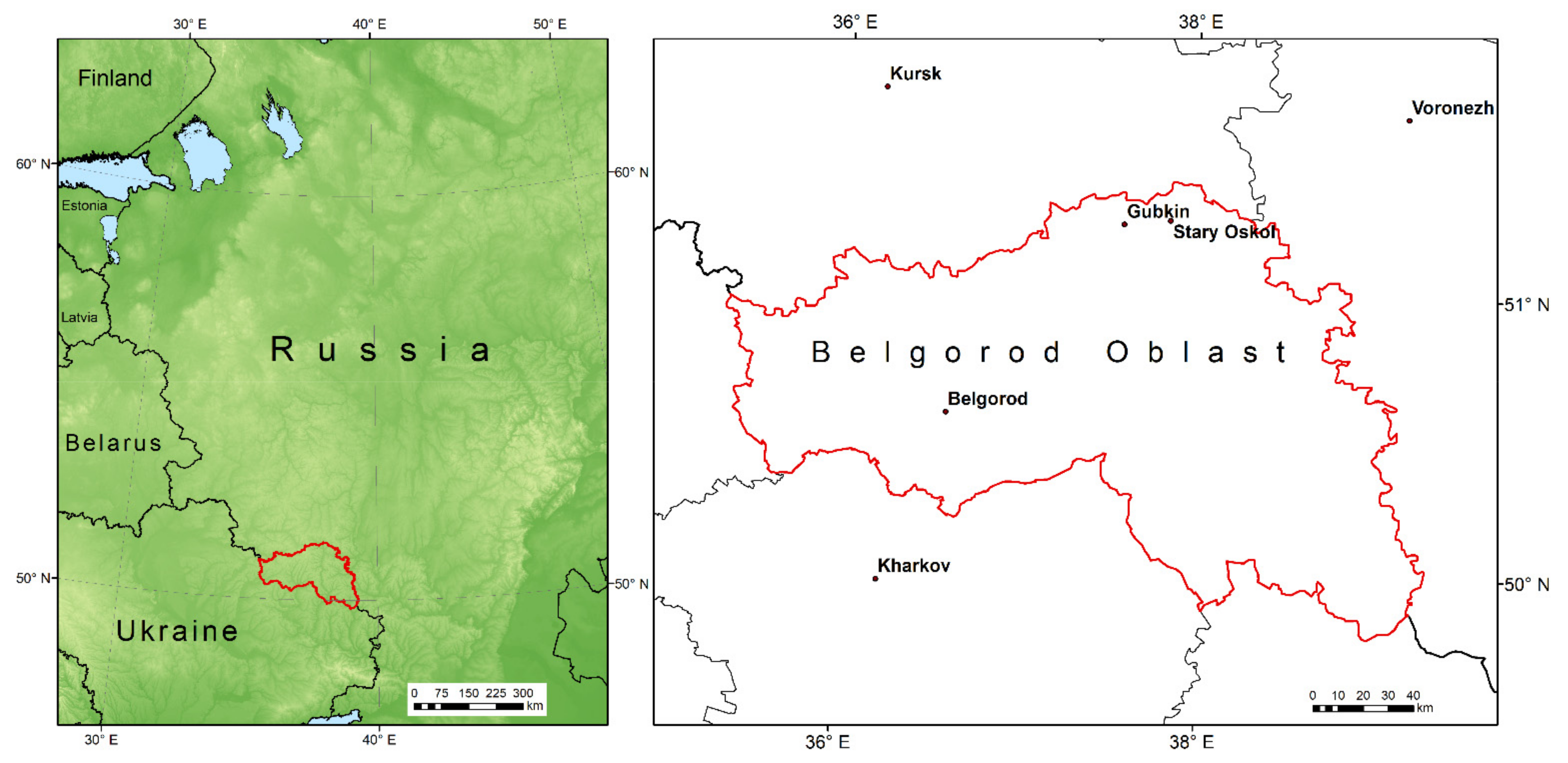
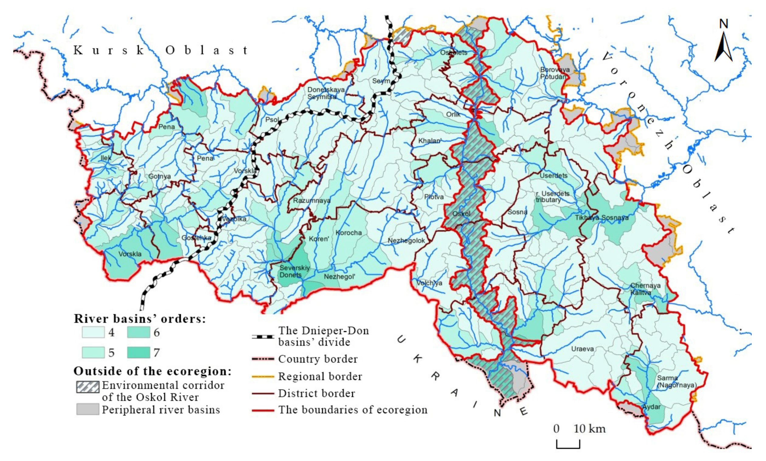
2.1. Study Area and Study Objects

Belgorod Oblast (27,100 km2) is one of the administrative regions of European Russia, located within the Central Russian Upland (Figure 1). Its territory is an elevated plain with a range of altitude of 68–277 m a.s.l. It is characterized by highly dissected terrain (up to 1.5 km/km2). The total length of the erosion network, including river valleys, is estimated at 22.5 × 10³ km. The depth of vertical dissection of the earth’s surface varies within 20–110 m. However, in the east of the region, the erosion forms of the Don River basin have an incision depth of 154–159 m. In these conditions, both sheet and linear erosion processes are active. More than 63.7% of this territory is presented by slopes inclined by more than 2°; about 46% (6944 km2) of them belong to arable land [109]. It should be noted that the share of arable land on slopes where erosion is already manifested, i.e., with a steepness over 2°, is 59.6%; 34% of arable land slopes exceed 3° (Figure 2). The prevalence of slope-type agricultural landscapes and a high proportion of arable land (60.6%) create favorable conditions for active water erosion processes.
The climate in the region is temperate continental. The average annual air temperature varies from +5.4 to +6.8 °C. The coldest month is January; the average monthly temperature varies across the territory from −7.5 °C to (in the south) −8.5 °C (in the north). The frost-free period is about 155–160 days. The soil cover of the region is very diverse, but chernozems prevail (Figure 2). Cropland occupies 61% of Belgorod Oblast. According to data of the detailed soil survey [110], the last rounds of which were carried out in the 1980s, more than half of Belgorod Oblast’s cropland is on uneroded soils; the share of eroded soils is about 48% of the total arable land area (Figure 2).
From 1950 to 1980, the growth rate of eroded areas was 5.1% in the western part of the region, 8.4% in the center, and 9.8% in the southeast part. Modern studies [111] using Earth remote sensing tools also confirm the growth of eroded areas nowadays: an assessment of highly eroded soil areas has shown their increase by 6% over the past 30 years.
A specific relief feature is the location of a zone of origin of large rivers in the western and central parts of Belgorod Oblast. Because of this, the ecological situation in this territory is essentially independent of the problems related to the quantity and quality of river flow in adjacent areas [107]. For regional monitoring, it is advisable to choose the fourth-order river basins since they reflect the specific features of local environmental management and, if necessary, allow monitoring of rapid changes due to human activities. We identified 217 river basins (fourth-to-seventh-orders) within Belgorod Oblast (Figure 3).
Belgorod Oblast’s ecological region (ecoregion) is a relatively hydrologically isolated integral natural-economic formation. It is an optimal object for basin-based nature management and geoplanning, and for establishing a multi-level system for land and water resource monitoring. The ecoregion is wholly or partially formed by 52 river basins, including 188 watersheds (subbasins) from the fourth to seventh order. Their external borders are entirely located within Belgorod Oblast. These watersheds occupy about 90% of the region’s area. Peripheral (incomplete or fragmentary) basins, which occupy 3.4% of the study area (Figure 3), cannot be subject to fully fledged geoecological monitoring. However, the basin-wide environmental management projects include these areas.

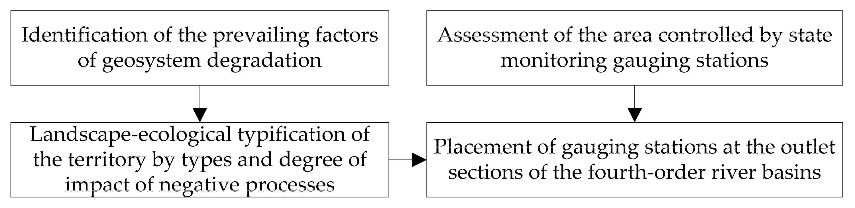
2.2. Methodology for Solving the Problem

When deploying a regional monitoring network, the first step is to determine the dominant degradation factors (Figure 4), which may differ depending on the natural area, terrain, geoecological conditions, and so on.
At the second stage of monitoring network development, it is necessary to identify the location of homogeneous territories by type and degree of the negative process using a point assessment and principles of landscape-environmental zoning. Approaches to complex score assessment of land degradation are widely covered [112,113,114,115,116]. The types of soil degradation, of which there are already several dozen, as well as the degree of their manifestation in specific landscape conditions, should be mapped, reflecting in the legend the landscape-ecological typification of the territory. These results form the basis for the localization of relatively homogeneous landscape units as territorial objects of the monitoring network. On the other hand, there is a state system of hydroecological monitoring, which makes it possible to assess the results of natural and anthropogenic development of landscapes for a controlled area, according to data in the outlet section of permanent streams. Using the results of the landscape-ecological typification of the territory, it is possible to determine to what extent the existing network of river gauging stations is rational and sufficient, limiting the scope of monitoring to an economically acceptable level of the hierarchy, e.g., river basins of the fourth order. In 2011–2015, several projects were implemented to arrange river basins following the criteria for the protection of soil and water resources on a single conceptual and technological basis [102,117,118]. The design was based on establishing an integration geoinformation platform, which can combine spatial data on individual components of Belgorod Oblast’s landscapes (about 30 thematic layers and 200 × 103 objects) and digital data on their economic use and ongoing observations (soils, surface/underground water, vegetation, etc.). Among the administrative regions of the Russian Federation, this is the only example of introducing a basin-based structure for nature management using 121 completed projects (covering about 2572 × 103 ha) for the entire region of the country (Belgorod Oblast). The current stage of the introduction of basin-based nature management projects using a basin-administrative approach within agricultural landscapes has shown the urgent need to establish a system to monitor both design solutions and their effectiveness.

2.3. Justification of the Initial Data

The leading indicators used for ecological-hydrological typification and zoning are very diverse [23,38,57,119]. For example, they include hydroclimatic conditions; morphometric indicators of the relief (the depth of local erosion base levels, slope steepness, terrain roughness); soils (their genesis and particle size distribution); potential erosion processes hazard and actually eroded soils; agricultural land use (cropland area, crop rotation, etc.); the area of forest cover, lakes, and marshes; urbanization; land reclamation; hydrological characteristics (water discharge, water intake, suspended sediment concentration, etc.); hydrochemical characteristics (mineralization, salinity, toxic substances, etc.); hydrobiological features (phytoplankton and zooplankton biomass, aquatic higher plants, respiratory intensity, etc.). A set of data may vary depending on typification tasks. To organize the geodata for each river basin with its inherent morphological, functional, and process characteristics, as well as information about the basin structure and the network of monitoring points for water bodies in Belgorod Oblast, the database “Basin Organization of Nature Management: Design and Monitoring” was formed [107]. It is based on European experience in river network monitoring within the framework of WFD [84] and creating a unified spatial data infrastructure [120]. Considering the European directive INSPIRE’s requirements, the database structure’s organization makes it possible to integrate regional spatial data into the pan-European information space. However, when using European approaches to hydroecological monitoring, it is necessary to consider the difference in understanding of the monitoring object: in Europe, the emphasis is on environmental control of watercourses [84,121,122], while we have justified the watershed as a geosystem, which is connected by united hydrological processes. The hydrographic-geographical typification proposed in this work is mainly aimed at solving soil conservation problems. Therefore, we have selected groups of target indicators, which show land use organizational structure, hydrometeorological conditions, erosion processes, and the actual state of watershed’s agricultural lands. To typify river basins of the same scale level, we used seven key factors, each of which was selected according to the essential criterion for the set objective (Table 1).
A quantitative assessment of arable land and forest areas was obtained in ArcGIS 9.2 based on an overlay of digital vector maps of land, which were updated using high-resolution satellite images. The proportion of the area occupied by the southern exposure slopes (Ss) was calculated based on the exposure distribution raster obtained from the DEM with a sample of azimuth values ranging from 135 to 225°. The soil erosion parameter (Es) was expressed in terms of the weighted average yield coefficient for cereals depending on the degree of erosion and soil subtype. Calculations of the weighted average Es for each basin were carried out using the vector soil layers and erosion overlay method. The Slope Length and Steepness (LS) Factor (relief function values) were calculated using the [123] formula. From the resulting raster of LS values, the average LS values for each basin were determined using the ZonalStatistics tool. The river network density (K) was estimated using electronic topographic maps at a scale of 1: 200,000. Using the Field Calculator in the attribute table of the vector layer, the values of the K parameter were also determined for each basin. The erosion index of precipitation (P) is defined as the product of the kinetic energy of rainfall and its 30 min intensity [124]. The distribution raster of the P exponent was obtained using the SpatialAnalyst module by extrapolating the contours; using ZonalStatistics, a weighted average P was determined for each river basin.

2.4. Methods of Data Preparation

Various methods were applied to determine the spatial distribution of each parameter: map-morphometric technique, geoinformation mapping/modeling, and remote sensing. The selected characteristics are not intercorrelated, and they can comprehensively reflect the ecological and economic status of the landscape basin structures. The source materials included digital land-use maps (1:25,000), topographic maps, soil erosion survey materials, a cartogram of the rainfall erosion index [124], and the results of our previous studies, i.e., digital maps of river basin boundaries and erosion networks [122], statistical data provided by the Department of Agro-Industrial Complex and Environmental Restoration of Belgorod Oblast. Some characteristics (woodland and plowing area; soil erosion; LS-factor [123]; the proportion of the southern aspect slopes area; the erosion index of precipitation; the river network density) are not correlated between themselves. This requires both separate and synthetic analyses of their territorial distribution. In this paper, using the STATISTICA 10.0, river basins of homogeneous types are selected based on the factors limiting the use of natural resources in Belgorod Oblast. Digital vector layers of contour lines and elevations obtained from topographic maps at a scale of 1: 25,000 served as the basis for constructing the DEM. The study used the tools of the ArcGIS 10.2.2 software package to produce slope maps, slope length, and slope exposure (“Surface Tools”), to calculate relief function values by the formula [123] (Map Algebra), and to determine weighted averages for the basins studied (Zonal Statistics), etc.

2.5. Classification of Objects

According to various estimates [6,110], soil cover in Belgorod Oblast is being destroyed due to water erosion, with an average annual rate of 6 to 12 t ha−1. As a result, among the five administrative regions that make up the Central Chernozem Region of European Russia with an area of 167,856 km2, Belgorod Oblast is the most prone to erosion (the share of eroded soils reached 60% of the area) and the length of the river network has decreased by 38% over the last 200 years [118]. The choice of a set of informative key parameters for the hierarchical classification of watersheds needed to reflect the complexity of natural and economic conditions that would characterize the predisposition of the territory to the manifestation of water erosion (geomorphological, soil, climatic, and ecological conditions). It would also have spatial variation across the region. The coefficient of variation for a sample of 188 river basins (Table 1) for six indicators exceeds 25% (a substantial degree of variation) and is less only for the indicator of hydrometeorological conditions, the erosion index of precipitation, the value of which uniformly increases from the southeast to the northwest over the territory of Belgorod Oblast, varying from 7.8 to 9.1.
An algorithm of tree-like clustering by Ward’s method in the square of Euclidean distance was used to typify the studied river basins. The classification into groups includes a basic grouping procedure. We used the cluster analysis technique hierarchic classification (unification by Ward’s method) based on the most informative indices normalized through mean-square deviation. Subsequent evaluation, which determines the correctness of the classifications, is important. In a specific study, a grouping of sample points of a multidimensional space can be provided by both the procedure of cluster analysis and a meaningful interpretation of the result using the values of threshold distance [125]. In our case, this allowed all of the river basins (n = 188) to be grouped into larger sets so that they were hierarchically classified. Two grouping boundaries were used using the values of threshold distance (D): D is 25 (basin type), and D is 12 (basin subtype) (Figure S1). It is important to note that the role of the selected seven factors (topography, climate, soil, and ecology) is changed in individual clusters.

2.6. Evaluation Criteria

The composition of the agroecological and hydroecological criteria for monitoring includes both traditional indicators (three indicators of the land-fund structure; seven indicators of soil quality; three indicators of water quality) and three complex ecological coefficients. The coefficient of environmental sustainability [126] is calculated by the ratio of the areas of “destabilizing” lands (industry and infrastructure, arable land, perennial plantations, and reclaimed fodder lands) to “stabilizing” lands (nature reserves, forest land, hayfields, moderately used pastures etc.) within the basins. The rating scale of this coefficient includes five gradations, from below the optimum by more than 10% (KES > 2.41) to above the optimum by more than 10% (KES < 0.39). The ecological stability coefficient (KES) [127] is calculated by the Formula (1):
  K E S = 1 n A i S i A
where Si is the score corresponding to the area with certain natural security; A is the total area of the study; Ai is the area of the corresponding type of land (i). The range of KES values can vary from <0.33 (environmentally unstable situation) to >0.67 (environmentally stable condition). The coefficient of natural protection [127] is calculated by the ratio between the areas of “stabilizing” and “destabilizing” lands. The rating scale of this coefficient includes five gradations, from critical (≤0.45) to favorable (≥0.71).

3. Results

3.1. Development of Soil Protection Projects for River Basins

There is a basin environmental management project in Belgorod Oblast, which is unique for the Russian Federation [45]. This regulation provides scientific justification for measures to create conditions for the sustainable functioning of ecosystems in the river basins of Belgorod Oblast. The concept was adopted based on the development conducted by Belgorod State National Research University scientists concerning soil and water protection arrangement of small river basins [107,117], design stages, and methods for basin environmental management [102,128,129].
Any basin environmental management project includes materials that assess the use of natural resources and the environmental/ecological situation in a basin, as well as support for a program of actions tailored to achieve watershed quality targets for natural resources and an environment subject to sustainable and environmentally friendly development of the regional economy. The basin nature management concept was implemented through land-use planning projects for 63 river basins ranging from 67 to 1517 km2, which cover the entire Belgorod Oblast. The practical implementation of the projects began in 2015.
The Belgorod Oblast’s executive authority controlled the standard for the project preparation method statement, ensured a stable annual scope of work, and formed a single base of electronic project data. The municipal authorities, as work commissioners, provided a significant portion of original data, accepted design solutions on the watershed areas, i.e., took responsibility for their implementation. A large number of participants from local authorities was one of the main problems related to the implementation of basin environmental management projects throughout the entire regional territory. For instance, the measures on the optimization of gully network use required the involvement of more than 330 rural settlements (communities) which had to hold meetings of locals in a short time, determine areas for grazing and conservation of natural forage lands, adopt regulatory documents, and carry out measures for afforestation of low-productive and erosion-dangerous lands. The Government of Belgorod Oblast applied the project management standard to implement this activity. As a result, the projects on conservation of natural forage lands, afforestation within unproductive and degraded lands, restoration and arrangement of water springs, and ecotourism development were successfully implemented in cooperation with regional and municipal authorities.
It became much more challenging to implement the measures on arable land for irrigation of hollows (small dry valleys), creation of protective forest stands, and introduction of soil protection crop rotations, due to the reluctance of local farmers to reduce arable land area and additional costs for the implementation of environmental protection measures. In this regard, first, several legal acts were adopted at the regional level, including those obliging end users of arable land to develop and implement projects for adaptive landscape systems of agriculture and soil protection. Second, a regional service was established to monitor and control the rational use of agricultural land and soil protection. In addition, the Belgorod Oblast’s Government took systematic efforts to use the regional budget to subsidize land-users who introduced the No-till soil protection system, engaged in chemical reclamation of acidic soils, and implemented meadow and forest reclamation activities.
To coordinate the activities in this field, the Department of Agro-Industrial Complex and Environmental Restoration introduced a departmental geoinformation system (geoportal). A specific feature of this system is that it can maintain real-time data exchange between the server part (geoportal), smartphones, and tablets of government employees. This system can also accept telematics data from agricultural machinery, remote sensing data (Sentinel), and public cadastral map data.

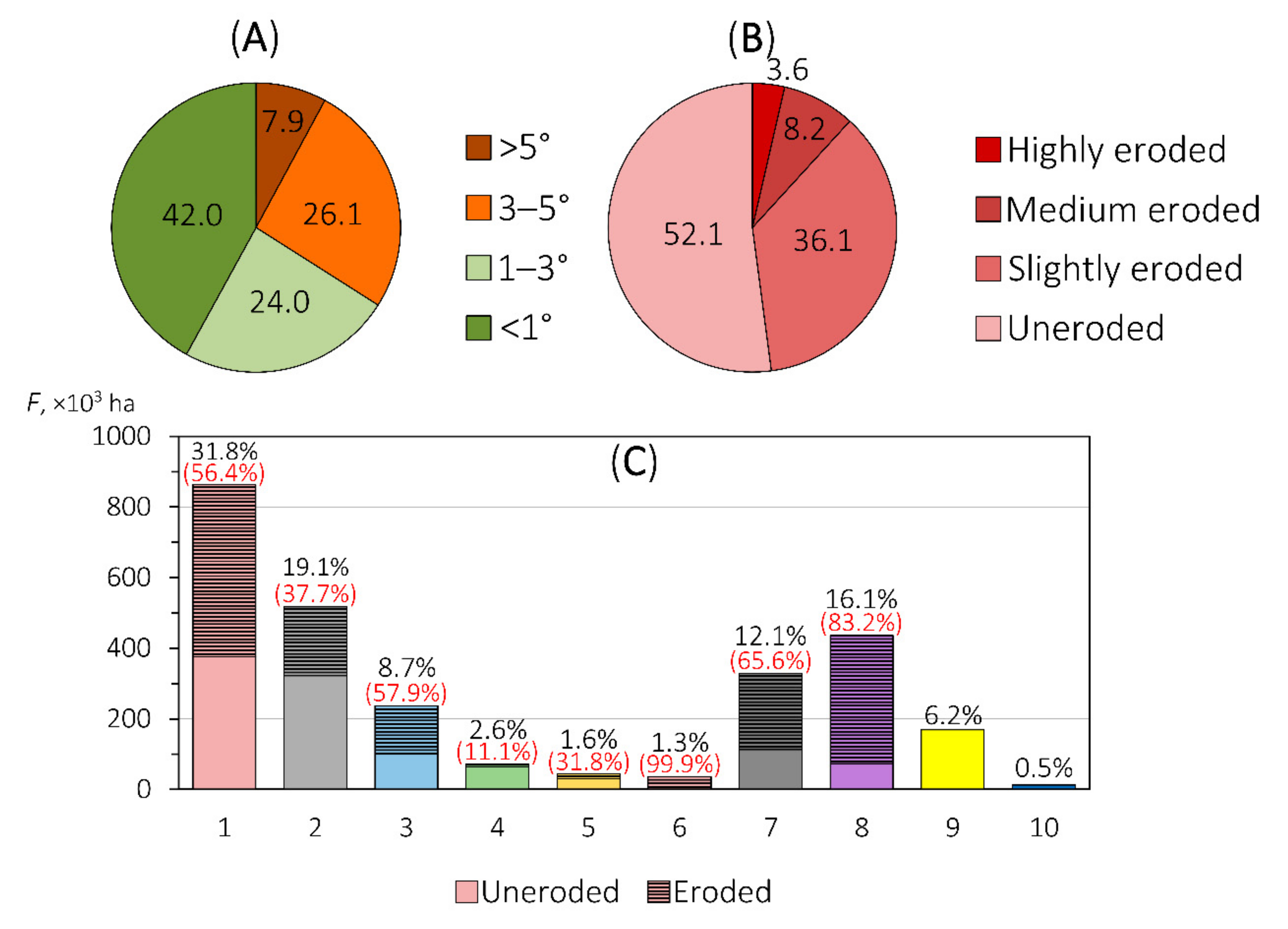
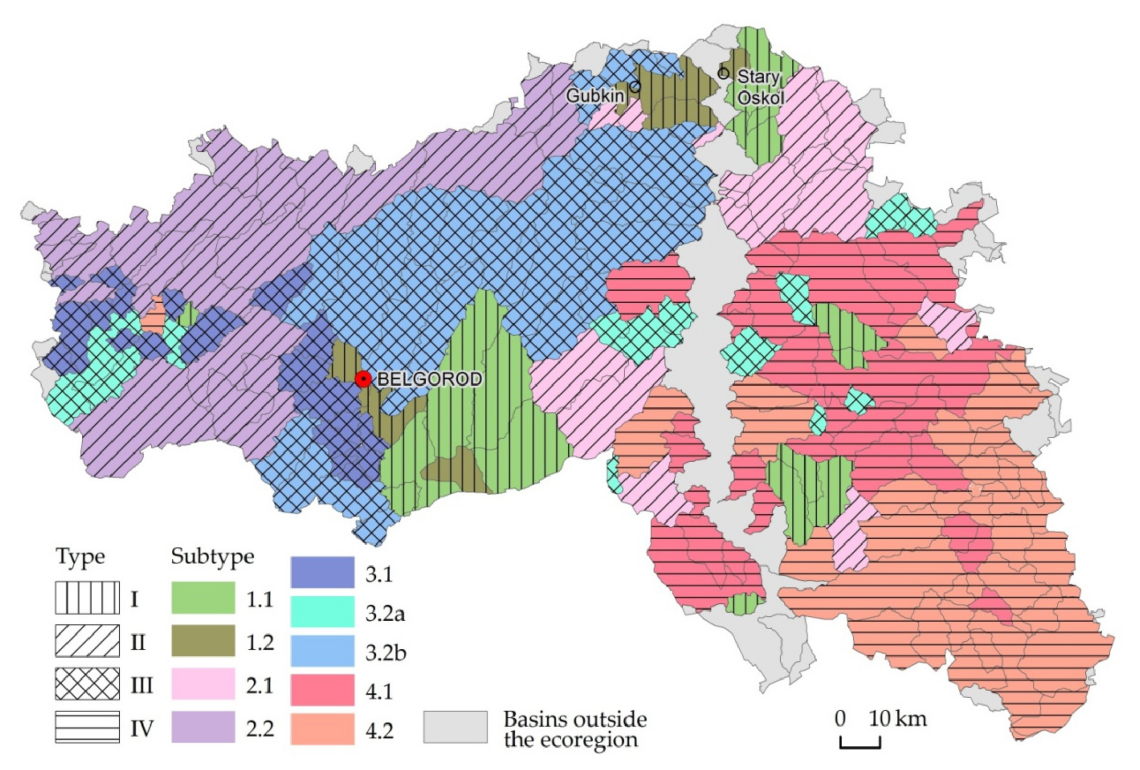
3.2. Typification of River Basins by Environmental and Erosion Criteria

An analysis of the potential of the prevailing negative processes within Belgorod Oblast has shown that this is primarily water erosion of soils. Therefore, agroecological monitoring of Belgorod Oblast should contain detailed information on water erosion processes (sheet/rill/gully erosion) in agricultural landscapes. The most informative indicators considering topography, soil, and climatic-environmental conditions are selected for river basin typification (Table 2).
As a result of cluster analysis, the river (sub)basins are aggregated by anthropogenic transformation criteria: plowing and forest area (Figure S1). They formed four types. According to the terrain conditions in the selected types, there are nine subtypes of predisposition to water-erosion processes (Table 2, Figure 5):
Subtype 1.1. The basins, which fall under the first type, have a relatively large forest area and a relatively small arable land area. They have the most favorable ecological and economic conditions because the areas of forests and arable land are approximately equal. Such basins serve as a relative reference for environmentally sustainable territories, but their share in the total area of the ecoregion is insignificant (only 9.5%).
Subtype 1.2. Environmentally unstable basins where the main centers of settlement and industrial development are located: the cities of Belgorod, Shebekino, Stary Oskol, Gubkin, and the iron ore-mining complex of the Kursk Magnetic Anomaly. Due to their technology-related transformation, these basins are isolated from other inter-settlement territories.
Subtype 2.1. A group of (sub)basins in the central and north-eastern part of Belgorod Oblast. They belong to the basins of the Oskol River and Potudan’ River. The basins of this subtype are characterized by very high plowing (66%) and small forestland area (8%). The basins’ soils are poorly eroded, and the topography and climate conditions are quite favorable (LS = 1.7, p = 8.3). The specific feature of this subtype is that one-quarter of its territory was affected by glaciation during the Middle Neopleistocene. The parent materials are mainly water-glacial sand deposits that have formed sandy and sandy-loam soils. These soils are subject to wind erosion.
Subtype 2.2. These are the basins with weakly eroded soils in the forest-steppe zone with a small forestland area. They are similar to subtype 2.1 and experience an intense agrogenic load (stress). The topography of this subtype of river basins is quite favorable (LS = 1.7, the proportion of the area of the southern slope is 21%), which reduces the risk of intensive surface water runoff. However, compared with subtype 2.1, the probability of intense rainfall is higher there (p = 8.9).
Subtype 3.1. This subtype is characterized by average afforestation and plowing areas (more than 45%) under difficult topographic conditions. We should consider separately a group of the (sub)basins of the Vorskla River basin with a combination of high soil erosion and a relatively high forestland area (16%). This combination is unusual for the forest-steppe zone. The reason is that dark grey forest soils were actively developed on this territory after deforestation during the 17–19th centuries. These soils are extremely unstable to erosion processes (compared to chernozems), which has resulted in soil cover degradation and forming medium and strongly washed-out soils.
Subtype 3.2a. This subtype is not characterized by territorial uniformity: small-area river (sub)basins are dispersed in the central and western parts of the study region. Out of all subtypes, this feature has the smallest share of the area of south-oriented slopes (19%), which makes this subtype’s river (sub)basins less vulnerable to erosion processes during spring snow melting.
Subtype 3.2b presents an extensive array of river (sub)basins with slightly eroded soils in the central part of the study region. These territories are characterized by high agrogenic load and low environmental stability: plowing area, 60%; woodland, 7%. It makes them similar to subtype 2.2. The erosion potential of the topography determines the difference between them. This subtype is characterized by higher values of the LS-factor (LS = 2.4) and a large share of the area of the southern slopes.
Subtypes 4.1 and 4.2 include (sub)basins of type 4, which have highly eroded soils in the east of the ecoregion and more than 50–60% of arable land. The forestland area of these subtypes is extremely small, especially in subtype 4.2 (3.5%). Subtypes 4.1 and 4.2 mainly differ in topography-induced erosion hazard: for the former, the terrain function (LS-factor) is the highest of all the listed subtypes (LS = 3.1); for the latter, it is slightly less—Ls = 2.5.

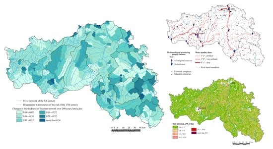
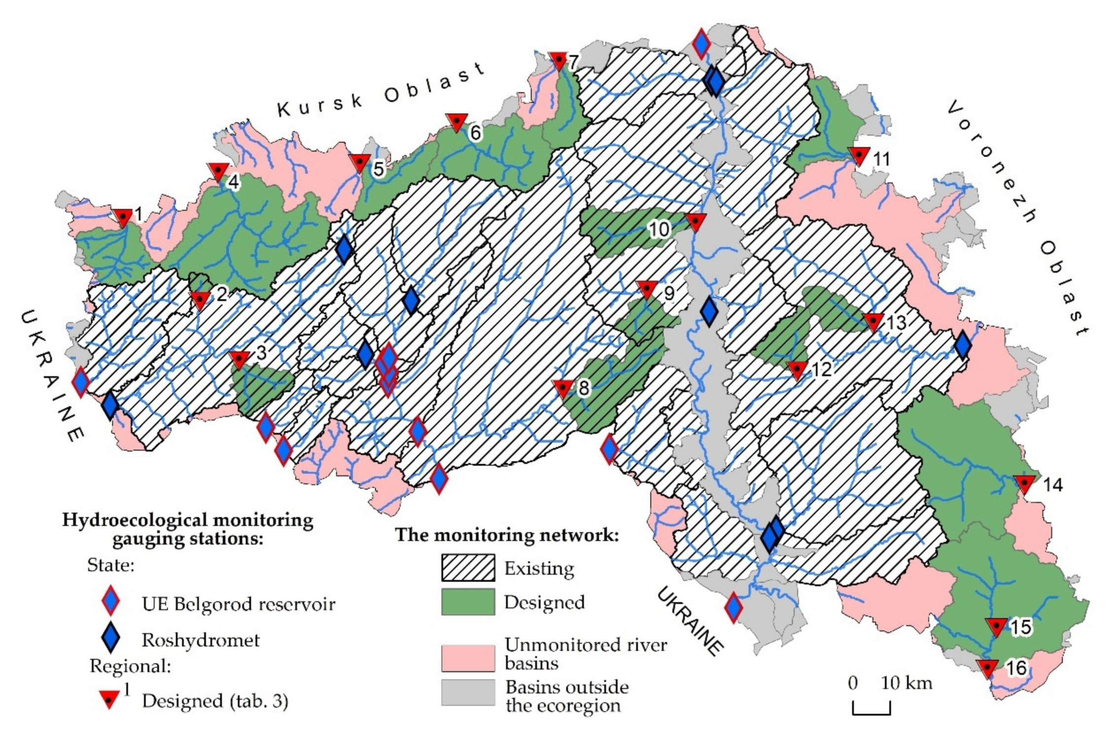
3.3. Justification for a Sustainable Network of Hydroecological Monitoring

Several levels of hydrological monitoring can be highlighted: local (within industrial centers, cities), regional (river basins), and state monitoring. An essential feature of a river basin is its hydrological characteristic, which makes it possible to draw up the water balance and model the spatial moisture content of the entire basin surface based on rainfall information and data on water discharge in river outlet sections. Environmental and anthropogenic factors determine spatiotemporal heterogeneity, which significantly influences the location and number of river basins monitored, monitoring stations, and the frequency of sample collection [77]. It is rational to place a sufficient amount of monitoring stations to represent the general state of rivers and watersheds of the ecoregion, to minimize economic costs during a monitoring arrangement. A regional monitoring network should complement the state one [70]; thus, its configuration should be planned with due account for maximum territorial coverage. To achieve this, it is advisable to estimate the total area of a (sub)basin (Figure 4), the state of which is monitored at the existing state-run monitoring stations. The existing hydrological gauging stations are, as a rule, confined to river basins with large human settlements and industrial objects. The regional network should be predominantly located in agriculturally developed basins, which are not covered by national hydrological monitoring.
Hydroecological monitoring arranged in the river (sub)basin outlets provides an idea of the amount of dispersed pollution, which is mainly caused by agriculture. It also gives an integral view of migration and accumulation of substance flows within a river (sub)basin: information on water discharge and suspended sediment load gives a generalized idea of the intensity of water-erosion processes in the (sub)basin; at the same time, the indicators of impurities of agrochemical origin allow for the estimation of the agro-geochemical state of the soil cover of the (sub)basin. Such an arrangement of monitoring stations can improve monitoring data accuracy while reducing cash costs [119].
A spatial analysis of the digital elevation model (DEM) of Belgorod Oblast has shown that the total area of (sub)basins with outlet gauging stations, being part of the national observation network, covers about 68% of its territory (Figure 6). From this, we have justified the optimum locations for regional hydroecological monitoring stations (Figure 6, Table 3).
When regional monitoring stations are placed according to the proposed scheme, the coverage area will increase by 1.26 times and make up 86% of the ecoregion’s area. For 100% coverage, the number of monitoring gauging stations needs to be raised at least twofold, which is not economically feasible. This problem can be solved using the results of (sub)basin typification of the Belgorod Oblast’s ecoregion. The state of river (sub)basins uncovered by the regional monitoring network (see Figure 6) can be estimated by analogy with monitored (sub)basins of the same subtype. It is expected that the water quality indicators will be similar for (sub)basins of the same subtype. First, this concerns the amount of suspended sediment and applied agrochemicals, since the key typification criteria were terrain erosion potential and cropland area. However, it should be borne in mind that hydrochemical indicators in (sub)basins of the same subtype may differ significantly in terms of impurities received from point sources of pollution (human settlements and industrial and agricultural objects).

4. Discussion

An integrated approach that should consider stakeholder interests and the economic value of water forms the basis of preventive measures for the sustainable utilization of water resources [130]. Considering the concept of basin environmental management, we implemented some land-use planning projects for the river basins, which cover the entire territory of Belgorod Oblast [5,107,117]. The basin-administrative approach for organizing a system of rational environmental management [117,131,132] was used because of the need to overcome the mismatch of natural and administrative (economic) borders in matters of information support, coordination of inter-farm land management, and coordination of environmental and economic projects at individual levels. The municipal budget funded the development of each basin management project with a 50% subsidy from the regional budget. Such a funding scheme has provided several advantages. On the one hand, the regional executive authority controlled the standard for the project preparation method statement, ensured a stable annual scope of work, and formed a single base of electronic project data. On the other hand, the municipal authorities as work commissioners provided a significant portion of original data and accepted design solutions in watersheds.
During the design, all arable land owned by agricultural producers, regardless of the form of ownership, was taken into account. The crop rotation fields, the areas pre-allocated for conservation (mainly highly eroded and/or unproductive), irrigation drains, contour forest strips, etc., were demarcated (Table 4).
As a result of arable land planning, it was proposed to organize three types of crop rotations: field type (68.8% of the projected arable land area), grain-grass type (21.8%), and soil protection type (6.2%). Part of the arable land is temporarily put under conservation to restore its productivity; 0.33% of the arable land located in the runoff concentration zone (shallow gullies) has permanent irrigation for surface water discharge into a hydrographic network. Polygonal forest strips should ensure that they protect the land against erosion.
According to the biologization program, about 10% of the sown area should be allocated for planting annual grasses, green manure, and catch crops during crop rotation; up to 50% of perennial grasses for grain-grass crop rotation; and up to 100% with conservation crop rotation. Based on the results of the design work, it was found that at least 2986.43 km2 of perennial grasses and 3627.92 km2 of green manures should be sown in Belgorod Oblast. Based on the average yield of perennial grasses and green manures, it was calculated that more than 5.7 × 10⁶ t of humus would be formed annually, and about 121 × 103 t of biological nitrogen would be accumulated.
The extent of eroded land prevalence in the list of monitoring indicators reflects the soil areas, which are subject to water erosion and classified by erosion degree with division into by land types. The effect of water erosion on soil state can also be estimated from the reserves of organic matter in the plow horizon of the soil [133,134,135]. These criteria are updated once every five years; an additional growth indicator should be introduced for the previous survey period to reflect the dynamics of water erosion processes. This shows whether water erosion processes are effectively regulated and how successfully agricultural landscape soil protection measures are being implemented. It is also promising to move from accounting individual factors of soil water erosion to assessing and predicting erosion hazard for agricultural landscapes by calculating the potential average annual soil erosion losses [136,137,138,139] and hazard evaluation of gully erosion [140,141].
The results of monitoring the implementation of measures determined by the basin environmental management projects showed that in 2019, arable land in the river basins of Belgorod Oblast was occupied by perennial grasses on an area of 1356.9 km2 and green manures on an area of 2789.34 km2, which amounted to 45.4% and 76.9% of the projected area, respectively. Since the start of the projects, 10.62 km2 of forest strips (42%) have been planted and 32.10 km2 of arable land have been converted to meadow vegetation. This has significantly changed the situation with the solution of soil protection problems.
The project was practically implemented on more than 330 rural settlements (communities). For the effective implementation of afforestation activities for low-yielding and erosion-dangerous lands, restoration and arrangement of water springs, determination of the legal status of plots for grazing, and conservation of natural forage lands, the Belgorod Oblast Government applied the project management standard, which was adapted for use in Belgorod Oblast’s public authorities [142].
Implementing cropland measures to irrigate hollows (small dry valleys), create protective afforestation, and introduce conservation crop rotations has become much more difficult due to the reluctance of local farmers to reduce their arable land and put themselves at risk due to the additional costs of environmental protection measures. In this regard, first, some legal acts were adopted at the regional level, including those obliging end users of arable land to develop and implement projects for adaptive landscape systems of agriculture and soil protection [143]. Second, a regional service was created to monitor and control the rational use of agricultural land and soil protection. In addition, the Belgorod Oblast Government [144] took systematic efforts to use the regional budget to subsidize land users who introduced the No-till soil protection system, engaged in chemical reclamation of acidic soils, and implemented meadow and forest reclamation activities.
The Department of Agro-Industrial Complex and Environmental Restoration introduced a departmental geoinformation system (geoportal) for the coordination of activities. A special feature of this system is that it can maintain real-time data exchange between the server (geoportal) part, smartphones and tablets of government employees; this system can also accept telematics data from agricultural machinery, remote sensing data (Sentinel), and public cadastral map data. In 2021–2022 the Department plans to expand the functionality of the departmental geoinformation system, primarily in terms of exchange of information in real time with the information systems of universities, specialized institutions, and agricultural enterprises.
All 21 municipalities of Belgorod Oblast are assessed based on the implementation of the basin management projects (Table 4). The municipalities regularly submit data on the state of their river basins to the Department of Agro-Industrial Complex and Environmental Restoration. It is possible to assess the effectiveness of basin-type environmental management by integrating agro- and hydro-ecological monitoring systems. For this purpose, a list of agro- and hydro-ecological criteria is proposed (Table 5).
The river (its regime and correlative sediments (channel sediment, floodplain alluvium, terrace deposits)) is the carrier of the most complete information about intra-basin events and natural and economic conditions of the entire catchment area, and the water masses of rivers most clearly diagnose these conditions. The estuary (the outlet section of watercourses) is the focus of key material and energy flows, such as surface and subsurface runoff of water masses and migration of dissolved substances and sediments. The most integral picture of the migration and accumulation of matter fluxes within the basin can be obtained by hydroecological monitoring if it is organized in the outlet section of watercourses. The basin approach harmoniously links the results of agroecological and hydrological (hydroecological) monitoring through common features and unidirectionality of the process of functioning of drainage basins. On the one hand, in the river (sub)basins, the state of the land, primarily for agricultural purposes, directly affects the water quality and the river’s hydrological regime. On the other hand, the peculiarities of water processes in slope systems determine the intensity of water erosion processes in agricultural landscapes, significantly affecting soil fertility. Prospects for the integration of agroecological monitoring of land use in catchments and hydroecological monitoring of surface waters are determined by the fundamental features and high information potential of the hydrographic network as a hierarchical cascade system, consisting of points of the confluence of lower-order channels into higher-order channels, the synergy of which is focused in the outlet section, up to the main mouth of the watercourse. The integration of agroecological and hydroecological monitoring makes it possible to assess the impact produced by human activities on the runoff and water balance in river basins. It is critical to rely on the landscape and hydrological principles [101,145] in such a case. This makes it possible to move from a point of any drainage basin to its entire area based on the studied patterns of changes in the water balance and hydrological regime of landscapes, which are typical of natural territory. This makes it possible to transfer the analysis from a point of any watershed area to its entire territory based on the studied patterns of changes in the water balance and hydrological regime of landscapes typical for natural areas [146]. Orderly and up-to-date information on the basin organization of the territory is fundamentally essential for environmental management, especially when planning the development of industries associated with the use of significant volumes of water resources [103]. This problem is wholly characteristic of Belgorod Oblast, where there are further plans to develop the enterprises of the iron ore complex and increase the volume of water consumed.
The modern hydrological monitoring system shows that since implementing the Basin Environmental Management Concept, several key indicators have improved in values (Figure 7).
An analysis of the data in Figure 7 (biochemical oxygen consumption (BOC5), ammonium nitrogen, cooper, nitrites, and phenols) shows that the river network has become less polluted. However, to assess the efficiency for the entire territory, it is necessary to expand the monitoring network, which will inevitably lead to economic costs. The next step in using our proposals should be the transition to an automated system of hydrological monitoring, which will ensure the stable functioning of the monitoring network and the information-technological base of territorial administrations, the creation of a single network resource, and interaction with external information systems [147,148]. In this regard, attention should be drawn to two existing water quality assessment approaches. The first group of methods intends to obtain a set of different characteristics [149,150] that reflect water quality assessment based on a detailed set of hydrochemical, microbiological and hydrological indicators. At the same time, they often do not give an unambiguous evaluation and refer to the same condition of water bodies by separate indicators to different classes of pollution. The second group includes monitoring methods that are based on the integration of its components, which allows us to obtain a reasonable idea of water quality in general. It is apparent that it is difficult to adequately convey all the information about a system as complex and multi-component as surface water. Nevertheless, integrated monitoring methods allow solving tasks related to identifying pollution classes from the spatiotemporal aspect and making operational decisions in the dynamics of water management and water protection situations. However, such methods are usually less expensive.
The European Water Framework Directive (WFD) focuses on hydrological and geomorphological processes and maintaining the ability of the water flow, in order to ensure the continuity of sediment transport along the river system [83]; the main emphasis in the implementation of the WFD is placed on monitoring the state of the hydrographic network [84]. The implementation of the concept of basin nature management, which we developed, differs in that after the completion of the design work, there was a period of implementation of soil and water protection measures in the watersheds of small rivers (2015–2021). Starting from 2022, a sediment removal program will be implemented in 39 river sections of the study region. Experience with hydro-biogeochemical modeling within the framework of WFD methodology has shown the need for the quality of water bodies on an intra-annual scale, which will require the development of more innovative monitoring systems by coupling both time-adaptative automated monitoring networks and modeling tools [151].

5. Conclusions

For all river basins of Belgorod Oblast, basin projects of nature management have been developed based on landscape and ecological principles in compliance with the requirements of the regulatory framework, including the regional one. The projects are being implemented in practice, and the first results show that the proposed measures are effective both for soil cover and for improving hydrological indicators.
Agroecological and hydroecological monitoring can be interlinked through the proposed system of 16 indicators that integrate soil cover and water quality in river basins. A combined analysis of data from such an integrated system will allow for the assessment of the impact of human activity on river basins’ runoff and water balance.
The development of an integrated monitoring system should be based on landscape and basin principles with due account for the existing network of national hydrological monitoring. However, it is advisable to supplement it with a regional network. The typification of river basins according to key environmental factors (terrain, climate, soil, ecological situations) is of great importance for understanding how integrated data on natural and economic conditions within the river (sub)basins should be taken into account for an efficient (that is, both minimized and most informative) two-level network of state and regional hydroecological monitoring system. There is a need to use a new approach to improve the hydroecological monitoring network, as the state network was created without considering the four types of river basins we established in the region. Therefore, additional gauging stations on the regional rivers will make it possible to obtain a complete picture of river flow formation depending on specific typical natural conditions. In addition to 117 river basins with 15,502 km2 area covered by the state monitoring network, the modernization proposed for Belgorod Oblast has enabled the provision of control over another 44 regional river (sub)basins with a total area of 5891 km2. The above studies allowed for determination of the optimal configuration of the regional monitoring network, which should increase the area covered by hydroecological monitoring from 16.7 × 10³ to about 21 × 103 km2, i.e., by 1.26 times.

Supplementary Materials

The following supporting information can be downloaded at: https://www.mdpi.com/article/10.3390/su14020927/s1, Figure S1: Results of the cluster analysis on erosion hazard and ecological status in 188 river basins of the Belgorod Oblast’s ecoregion. (A, B)—the border of the threshold for determining the types (subtypes) of basins (I–IV—types; 1.1–4.2—subtypes). Subtype 3.2a. This subtype is not characterized by territorial uniformity: small-area basins are dispersed in the central and western parts of the region. Out of all subtypes, this feature has the smallest share of southern slopes (19%), which makes the river basins of this subtype less vulnerable to erosion during spring melting of snow. Subtype 3.2b includes a large array of river basins on slightly eroded soils in the central part of the region. These territories are characterized by high agrogenic load and low environmental stability: cropland, 60%; woodland, 7%. This makes them similar to subtype 2.2. The difference between them is the erosion potential of the terrain: this subtype is characterized by higher values of LS-factor (LS = 2.4) and a large share of the area of the southern slopes. Supplementary material associated with this article (source database) can be found at 10.17632/43sp4rxzsh.1.

Author Contributions

Conceptualization, F.L. and Z.B.; methodology, F.L.; software, A.N.; validation, Z.B.; formal analysis, Z.B. resources, Z.B. and M.K.; writing—original draft preparation, Z.B., A.G. and A.N.; writing—review and editing, F.L., A.G.; visualization, Z.B. and A.N.; supervision, M.K. All authors have read and agreed to the published version of the manuscript.

Funding

This research was funded by the Russian Science Foundation (project no. 20-67-46017).

Institutional Review Board Statement

The study was conducted in accordance with the Declaration of Helsinki of 1975 (https://www.wma.net/what-we-do/medical-ethics/declaration-of-helsinki/, accessed on 30 October 2021) and follows the Ethical codex (https://www.aapor.org/StandardsEthics/AAPOR-Code-of-Ethics.aspx, accessed on 30 October 2021). The INESAN ethic review board does not require an additional ethics approval for such studies according to the ethical codex (https://inesan.eu/wp-content/uploads/2020/12/A_Eticky-kodex.pdf, accessed on 30 October 2021) because the institute holds a HRS4R HR Excellence in Research award (https://inesan.eu/en/hrs4r-2/, accessed on 30 October 2021). This award grants the highest level of ethical work carried by the researchers at this institute (https://www.euraxess.cz/jobs/hrs4r, accessed on 30 October 2021).

Informed Consent Statement

Not applicable.

Data Availability Statement

The data used to support the findings of this study were preposted to the repository Mendeley Data.

Conflicts of Interest

The authors declare no conflict of interest. The funders had no role in the design of the study; in the collection, analyses, or interpretation of data; in the writing of the manuscript; or in the decision to publish the results.

References

  1. Lehner, B.; Grill, G. Global river hydrography and network routing: Baseline data and new approaches to study the world’s large river systems. Hydrol. Processes 2013, 27, 2171–2186. [Google Scholar] [CrossRef]
  2. Nian, Y.Y.; Li, X.; Zhou, J.; Hu, X.L. Impact of land use change on water resource allocation in the middle reaches of the Heihe River Basin in northwestern China. J. Arid. Land 2014, 6, 273–286. [Google Scholar] [CrossRef] [Green Version]
  3. Wang, Z.; Wang, Z.; Zhang, B.; Lu, C.; Ren, C. Impact of land use/land cover changes on ecosystem services in the Nenjiang River Basin, Northeast China. Ecol. Processes 2015, 4, 11. [Google Scholar] [CrossRef] [Green Version]
  4. Astashin, A.E.; Pashkin, O.N.; Vatina, O.E.; Astashina, N.I.; Fomina, A.I. Dynamics of the length of the river network of elementary watercourses in the zone of broad-leaved forests under high anthropogenic pressure in the XXI Century (on the example of the catchment area of the Birlya river in the Republic of Tatarstan, Russia). IOP Conf. Ser. Earth Environ. Sci. 2021, 688, 012023. [Google Scholar] [CrossRef]
  5. Ivanov, M.A.; Yermolaev, O.P.; Maltsev, K.A.; Shynbergenov, Y.A. Geomorphometric analysis of river basins in East European Russia using SRTM and ASTER GDEM data. J. Eng. Appl. Sci. 2016, 14, 3080–3087. [Google Scholar]
  6. Koshovskii, T.S.; Zhidkin, A.P.; Gennadiev, A.N.; Ivanova, N.N. Diagnostics, genesis, and localization of pedosediments within a small catchment (Central Russian Upland). Eurasian Soil Sci. 2019, 5, 481–493. [Google Scholar] [CrossRef]
  7. Yermolaev, O.P.; Mukharamova, S.S.; Maltsev, K.A.; Ivanov, M.A.; Ermolaeva, P.O.; Gayazov, A.I.; Mozzherin, V.V.; Kharchenko, S.V.; Marinina, O.A.; Lisetskii, F.N. Geographic information system and geoportal river basins of the European Russia. IOP Conf. Ser. Earth Environ. Sci. 2018, 107, 012108. [Google Scholar] [CrossRef]
  8. Tagne, G.V.; Dowling, C. Land-use controls on nutrient loads in aquifers draining agricultural and mixed-use karstic watersheds. Environ. Monit. Assess. 2020, 192, 168. [Google Scholar] [CrossRef]
  9. Zhu, P.-Z.; Zhang, G.-H.; Zhang, B.-J.; Wang, H.-X. Variation in soil surface roughness under different land uses in a small watershed on the Loess Plateau, China. Catena 2020, 188, 104465. [Google Scholar] [CrossRef]
  10. Dukhovny, V.A.; Sokolov, V.I.; Ziganshina, D.R. Integrated water resources management in Central Asia, as a way of survival in conditions of water scarcity. Quat. Int. 2013, 311, 181–188. [Google Scholar] [CrossRef]
  11. Mukharamova, S.; Ivanov, M.; Yermolaev, O. Assessment of anthropogenic pressure on the Volga federal district territory using river basin approach. Geosciences 2020, 10, 139. [Google Scholar] [CrossRef] [Green Version]
  12. Sultana, J.; Tibby, J.; Recknagel, F.; Maxwell, S.; Goonan, P. Comparison of two commonly used methods for identifying water quality thresholds in freshwater ecosystems using field and synthetic data. Sci. Total Environ. 2020, 724, 137999. [Google Scholar] [CrossRef]
  13. Wang, G.; Zhou, S.; Han, X.; Zhang, L.; Ding, S.; Li, Y.; Zhang, D.; Zarin, K. Occurrence, distribution, and source track of antibiotics and antibiotic resistance genes in the main rivers of Chongqing city, southwest China. J. Hazard. Mater. 2020, 389, 122110. [Google Scholar] [CrossRef]
  14. Jabbar, F.K.; Grote, K. Statistical assessment of nonpoint source pollution in agricultural watersheds in the Lower Grand River watershed, MO, USA. Environ. Sci. Pollut. Res. 2019, 26, 1487–1506. [Google Scholar] [CrossRef] [Green Version]
  15. Stefanidis, K.; Panagopoulos, Y.; Mimikou, M. Response of a multi-stressed Mediterranean river to future climate and socio-economic scenarios. Sci. Total Environ. 2018, 627, 756–769. [Google Scholar] [CrossRef] [PubMed]
  16. Zhao, H.; Fu, Z.; Lu, W.; Guo, H. A risk analysis of interactive region of river and land area environmental systems. Acta Sci. Circumstantiae 2018, 38, 372–379. [Google Scholar]
  17. Kochurov, A.I.; Marunich, N.A.; Khaziakhmetova, Y.A.; Krasnov, E.V. The ecologically balanced structure of lands and energy efficiency of forestry management in Transnistria. Geogr. Nat. Resour. 2017, 38, 394–398. [Google Scholar] [CrossRef]
  18. Gagarinova, O.V.; Kovalchuk, O.A. Assessment of anthropogenic impacts on landscape-hydrological complexes. Geogr. Nat. Resour. 2010, 31, 291–295. [Google Scholar] [CrossRef]
  19. Prykhodko, M.M.; Romaniuk, V.V.; Kukhtar, D.V.; Bodnaruk, I.L.; Adamovych, M.V. Use of geoinformation technology to study the structure and morphometric parameters of river basins. In Proceedings of the Geoinformatics 2020—XIXth International Conference “Geoinformatics: Theoretical and Applied Aspects”, Kiev, Ukraine, 11–14 May 2020; p. 17532. [Google Scholar]
  20. Panchenko, E.M.; Dyukarev, A.G. The ecological-economic balance of the Ob’-Tom’ interfluve. Geogr. Nat. Resour. 2016, 4, 123–129. [Google Scholar]
  21. Miserendino, M.L.; Kutschker, A.; Brand, C.; Manna La, L.; Di Cecilia, P.Y.; Papazian, G.; Bava, J. Ecological status of a Patagonian mountain river: Usefulness of environmental and biotic metrics for rehabilitation assessment. Environ. Manag. 2016, 57, 1166–1187. [Google Scholar]
  22. Rulev, A.S.; Pugacheva, A.M. Formation of a new agroforestry paradigm. Her. Russ. Acad. Sci. 2019, 89, 495–501. [Google Scholar] [CrossRef]
  23. Fang, L.; Wang, L.; Chen, W.; Sun, J.; Cao, Q.; Wang, S.; Wang, L. Identifying the impacts of natural and human factors on ecosystem service in the Yangtze and Yellow River Basins. J. Clean. Prod. 2021, 314, 127995. [Google Scholar] [CrossRef]
  24. Moiseenko, T.I.; Soromotin, A.V.; Shalabodov, A.D. Kachestvo vod i metodologija normirovanija zagrjaznenija [Water quality and methodology of valuation of pollution]. Bull. Tyumen State Univ. 2010, 7, 4–13. (In Russian) [Google Scholar]
  25. DeLonge, M.; Basche, A. Leveraging agroecology for solutions in food, energy, and water. Elem. Sci. Anth. 2017, 5, 6. [Google Scholar] [CrossRef]
  26. Chen, Y.P.; Fu, B.J.; Zhao, Y.; Wang, K.B.; Zhao, M.M.; Ma, J.F.; Wang, H. Sustainable development in the Yellow River Basin: Issues and strategies. J. Clean. Prod. 2020, 263, 121223. [Google Scholar] [CrossRef]
  27. Li, Y.; Yen, H.; Harmel, R.D.; Lei, Q.; Zhou, J.; Hu, W.; Li, W.; Lian, H.; Zhu, A.-X.; Zhai, L.; et al. Effects of sampling strategies and estimation algorithms on total nitrogen load determination in a small agricultural headwater watershed. J. Hydrol. 2019, 579, 124114. [Google Scholar] [CrossRef]
  28. Brownson, K.; Fowler, L. Evaluating how we evaluate success: Monitoring, evaluation and adaptive management in Payments for Watershed Services programs. Land Use Policy 2020, 94, 104505. [Google Scholar] [CrossRef]
  29. Jerves-Cobo, R.; Benedetti, L.; Amerlinck, Y.; Lock, K.; De Mulder, C.; Van Butsel, J.; Cisneros, F.; Goethals, P.; Nopens, I. Integrated ecological modelling for evidence-based determination of water management interventions in urbanized river basins: Case study in the Cuenca River basin (Ecuador). Sci. Total Environ. 2020, 709, 136067. [Google Scholar] [CrossRef]
  30. Yang, G.; Moyer, D.L. Estimation of nonlinear water-quality trends in high-frequency monitoring data. Sci. Total Environ. 2020, 715, 136686. [Google Scholar] [CrossRef]
  31. Chalov, S.; Ermakova, G. Fluvial response to climate change: A case study of northern Russian rivers. IAHS Publ. 2011, 346, 111–119. [Google Scholar]
  32. Kairis, O.; Kosmas, C.; Karavitis, C.; Ritsema, C.; Salvati, L.; Acikalin, S.; Belgacem, A.; Solé-Benet, A.; Brito, J.; Chaker, M.; et al. Evaluation and selection of indicators for land degradation and desertification monitoring: Types of degradation, causes, and implications for management. Environ. Manag. 2014, 54, 971–982. [Google Scholar] [CrossRef]
  33. Marinina, O.A. Soil evaluation for land use optimizing. IOP Conf. Ser. Earth Environ. Sci. 2018, 107, 012015. [Google Scholar] [CrossRef]
  34. Golosov, V.; Belyaev, V. The history and assessment of effectiveness of soil erosion control measures deployed in Russia. Int. Soil Water Conserv. Res. 2013, 1, 26–35. [Google Scholar] [CrossRef] [Green Version]
  35. Yermolaev, O.; Mukharamova, S.; Vedeneeva, E. River runoff modeling in the European territory of Russia. Catena 2021, 203, 105327. [Google Scholar] [CrossRef]
  36. Simonov, Y.G.; Simonova, T.Y. River basin and basin organization of the landscape geosphere. Soil Eros. Channel Processes 2004, 14, 7–32. (In Russian) [Google Scholar]
  37. Ermolaev, O.P.; Mal’tsev, K.A.; Mukharamova, S.S.; Kharchenko, S.V.; Vedeneeva, E.A. Cartographic model of river basins of European Russia. Geogr. Nat. Resour. 2017, 38, 131–138. [Google Scholar] [CrossRef]
  38. Korytny, L.M. The basin concept: From hydrology to nature management. Geogr. Nat. Resour. 2017, 2, 111–121. [Google Scholar] [CrossRef]
  39. Puzachenko, Y.G. Application of fractal theory to the study of landscape structure. News Acad. Sci. Russ. Fed. Geogr. Ser. 1997, 2, 24–40. [Google Scholar]
  40. Ibrahim-Bathis, K.; Ahmed, S.A. Geospatial technology for delineating groundwater potential zones in Doddahalla watershed of Chitradurga district, India. Egypt. J. Remote Sens. Space Sci. 2016, 19, 223–234. [Google Scholar] [CrossRef] [Green Version]
  41. Liu, Y.; Yang, W.; Shao, H.; Yu, Z.; Lindsay, J. Development of an integrated modelling system for evaluating water quantity and quality effects of individual wetlands in an agricultural watershed. Water 2018, 10, 774. [Google Scholar] [CrossRef] [Green Version]
  42. Buryak, Z.; Grigoreva, O. A project-based approach to reduce the risk of soil erosion in agricultural landscapes of small river basins using GIS technologies. SGEM 2019, 19, 19–26. [Google Scholar]
  43. Abedin, S.J.H.; Stephen, H. GIS framework for spatiotemporal mapping of urban flooding. Geosciences 2019, 9, 77. [Google Scholar] [CrossRef] [Green Version]
  44. Voda, M.; Sarpe, C.A.; Voda, A.I. Romanian river basins lag time analysis. The SCS-CN versus RNS comparative approach developed for small watersheds. Water Resour. Manag. 2019, 33, 245–259. [Google Scholar] [CrossRef]
  45. Buryak, Z.A.; Zelenskaya, E.Y.; Poletaev, A.O.; Tsybenko, V.V. System approach to soil protection and ecological arrangement of watersheds at the regional level, Belgorod oblast. Ecol. Environ. Conserv. 2019, 25, 219–228. [Google Scholar]
  46. Ghorbani, M.A.; Kisi, O.; Aalinezhad, M. A probe into the chaotic nature of daily streamflow time series by correlation dimension and largest Lyapunov methods. Appl. Math. Model. 2010, 34, 4050–4057. [Google Scholar] [CrossRef]
  47. Li, H.; Wang, Y.; Li, X. Mechanism and forecasting methods for severe droughts and floods in Songhua River Basin in China. Chin. Geogr. Sci. 2011, 21, 531–542. [Google Scholar] [CrossRef]
  48. Singh, G.; Panda, R.K. Grid-cell based assessment of soil erosion potential for identification of critical erosion prone areas using USLE, GIS and remote sensing: A case study in the Kapgari watershed, India. Int. Soil Water Conserv. Res. 2017, 5, 202–211. [Google Scholar] [CrossRef]
  49. Pichura, V.I.; Domaratsky, Y.A.; Yaremko, Y.I.; Volochnyuk, Y.G.; Rybak, V.V. Strategic ecological assessment of the state of the transboundary catchment basin of the Dnieper River under extensive agricultural load. Indian J. Ecol. 2017, 44, 442–450. [Google Scholar]
  50. Nguyen, T.H.; Helm, B.; Hettiarachchi, H.; Caucci, S.; Krebs, P. The selection of design methods for river water quality monitoring networks: A review. Environ. Earth Sci. 2019, 78, 96. [Google Scholar] [CrossRef]
  51. Pichura, V.I.; Potravka, L.A.; Vasylivna, D.N.; Skrypchuk, P.M.; Stratichuk, N.V. Retrospective and forecast of heterochronal climatic fluctuations within territory of Dnieper basin. Indian J. Ecol. 2019, 46, 402–407. [Google Scholar]
  52. Guigues, N.; Desenfant, M.; Hance, E. Combining multivariate statistics and analysis of variance to redesign a water quality monitoring network. Environ. Sci. Process. Impacts 2013, 15, 1692–1705. [Google Scholar] [CrossRef]
  53. Liu, Y.; Zheng, B.H.; Wang, M.; Xu, Y.X.; Qin, Y.W. Optimization of sampling frequency for routine river water quality monitoring. Sci. China Chem. 2014, 57, 772–778. [Google Scholar] [CrossRef]
  54. Calazans, G.M.; Pinto, C.C.; da Costa, E.P.; Perini, A.F.; Oliveira, S.C. Using multivariate techniques as a strategy to guide optimization projects for the surface water quality network monitoring in the Velhas river basin, Brazil. Environ. Monit. Assess. 2018, 190, 726. [Google Scholar] [CrossRef]
  55. Loga, M.; Wierzchołowska-Dziedzic, A.; Martyszunis, A. The problem of water body status misclassification—A hierarchical approach. Environ. Monit. Assess. 2018, 190, 264. [Google Scholar] [CrossRef] [Green Version]
  56. Ovchinnikov, A.S.; Litvinov, E.A.; Rulev, A.S.; Kochkar, M.M.; Vorob’eva, O.M. Remote cartographic assessment of the erosion condition of agrolandscapes. J. For. Sci. 2017, 63, 485–489. [Google Scholar]
  57. Pichura, V.; Potravka, L.; Dudiak, N.; Stroganov, A.; Dyudyaeva, O. Spatial differentiation of regulatory monetary valuation of agricultural land in conditions of widespread irrigation of steppe soils. J. Water Land Develop. 2021, 48, 182–196. [Google Scholar]
  58. Batbayar, G.; Pfeiffer, M.; Kappas, M.; Karthe, D. Development and application of GIS-based assessment of land-use impacts on water quality: A case study of the Kharaa River Basin. Ambio 2019, 48, 1154–1168. [Google Scholar] [CrossRef]
  59. Bussan, D.D.; Ochs, C.A.; Jackson, C.R.; Anumol, T.; Snyder, S.A.; Cizdziel, J.V. Concentrations of select dissolved trace elements and anthropogenic organic compounds in the Mississippi River and major tributaries during the summer of 2012 and 2013. Environ. Monit. Assess. 2017, 189, 73. [Google Scholar] [CrossRef]
  60. Česonienė, L.; Sileikiene, D.; Dapkiene, M.; Radzevicius, A.; Räsänen, K. Assessment of chemical and microbiological parameters on the Leite River Lithuania. Environ. Sci. Pollut. Res. 2019, 26, 18752–18765. [Google Scholar] [CrossRef]
  61. Li, R.; Tang, X.; Guo, W.; Lin, L.; Zhao, L.; Hu, Y.; Liu, M. Spatiotemporal distribution dynamics of heavy metals in water, sediment, and zoobenthos in mainstream sections of the middle and lower Changjiang River. Sci. Total Environ. 2020, 714, 136779. [Google Scholar] [CrossRef]
  62. Chapman, D.V.; Bradley, C.; Gettel, G.M.; Hatvani, I.G.; Hein, T.; Kovács, J.; Várbíró, G. Developments in water quality monitoring and management in large river catchments using the Danube River as an example. Environ. Sci. Policy 2016, 64, 141–154. [Google Scholar] [CrossRef] [Green Version]
  63. Liu, L.; Jiang, T.; Xu, H.; Wang, Y. Potential threats from variations of hydrological parameters to the Yellow River and Pearl River Basins in China over the next 30 years. Water 2018, 10, 883. [Google Scholar] [CrossRef] [Green Version]
  64. Frolova, N.L.; Kireeva, M.B.; Magritckiy, D.V.; Bolgov, M.B.; Kopylov, V.N.; Hall, J.; Semenov, V.A.; Kosolapov, A.E.; Dorozhkin, E.V.; Korobkina, E.A.; et al. Hydrological hazards in Russia: Origin, classification, changes and risk assessment. Nat. Hazards 2017, 88, 103–131. [Google Scholar] [CrossRef]
  65. Tanos, P.; Kovács, J.; Kovács, S.; Anda, A.; Hatvani, I.G. Optimization of the monitoring network on the River Tisza (Central Europe, Hungary) using combined cluster and discriminant analysis, taking seasonality into account. Environ. Monit. Assessment 2015, 187, 575. [Google Scholar] [CrossRef]
  66. Ge, M.; Wu, F.; Chen, X. Using multiple discriminant analysis for the assignment of initial water entitlements at river basin-level under the strictest water resources management system constraints in China. Sustainability 2018, 10, 4414. [Google Scholar] [CrossRef] [Green Version]
  67. Eldho, T.I.; Jha, A.; Singh Anupam, K. Integrated watershed modeling using a Finite Element Method and GIS approach. Int. J. River Basin Manag. 2006, 4, 17–25. [Google Scholar] [CrossRef]
  68. Acreman, M.; Dunbar, M.J. Defining environmental river flow requirements—A review. Hydrol. Earth Syst. Sci. 2004, 8, 861–876. [Google Scholar] [CrossRef]
  69. King, R.S.; Baker, M.E.; Whigham, D.F.; Weller, D.E.; Jordan, T.E.; Kazyak, P.F.; Hurd, M.K. Spatial considerations for linking watershed land cover to ecological indicators in streams. Ecol. Appl. 2005, 15, 137–153. [Google Scholar] [CrossRef] [Green Version]
  70. Nomquphu, W.; Braune, E.; Mitchell, S. The changing water resources monitoring environment in South Africa. S. Afr. J. Sci. 2007, 103, 306–310. [Google Scholar]
  71. Tran, C.P.; Bode, R.W.; Smith, A.J.; Kleppel, G.S. Land-use proximity as a basis for assessing stream water quality in New York State (USA). Ecol. Indic. 2010, 10, 727–733. [Google Scholar] [CrossRef]
  72. Keeler, B.L.; Polasky, S.; Brauman, K.A.; Johnson, K.A.; Finlay, J.C.; O’Neille, A.; Kovacs, K.; Dalzell, B. Linking water quality and well-being for improved assessment and valuation of ecosystem services. Proc. Natl. Acad. Sci. USA 2012, 109, 18619–18624. [Google Scholar] [CrossRef] [Green Version]
  73. King, J.M.; Brown, C. Environmental flow assessments are not realizing their potential as an aid to basin planning. Front. Environ. Sci. 2018, 6, 113. [Google Scholar] [CrossRef]
  74. Schuwirth, N.; Honti, M.; Logar, I.; Stamm, C. Multi-criteria decision analysis for integrated water quality assessment and management support. Water Res. X 2018, 1, 100010. [Google Scholar] [CrossRef] [PubMed]
  75. Andrew, R.G.; Burns, R.C.; Allen, M.E. The influence of location on water quality perceptions across a geographic and socioeconomic gradient in Appalachia. Water 2019, 11, 2225. [Google Scholar] [CrossRef] [Green Version]
  76. Eamen, L.; Brouwer, R.; Razavi, S. The economic impacts of water supply restrictions due to climate and policy change: A transboundary river basin supply-side input-output analysis. Ecol. Econ. 2020, 172, 106532. [Google Scholar] [CrossRef]
  77. A Handbook for Integrated Water Resources Management in Basins; Global Water Partnership (GWP); International Network of Basin Organizations (INBO): Stockholm, Sweden, 2009.
  78. Fritsch, O.; Benson, D. Mutual learning and policy transfer in integrated water resources management: A research agenda. Water 2020, 12, 72. [Google Scholar] [CrossRef] [Green Version]
  79. Haroun, M.; Punjabi, S.; Suboyin, A.; Anastasiou, S.; de Bakker, J. Integrated management of water resources: A novel approach for water-stressed regions. Syst. Res. Behav. Sci. 2019, 36, 827–834. [Google Scholar] [CrossRef]
  80. Krol, M.S.; de Vries, M.J.; van Oel, P.R.; de Araújo, J.C. Sustainability of small reservoirs and large-scale water availability under current conditions and climate change. Water Resour. Manag. 2011, 25, 3017–3026. [Google Scholar] [CrossRef] [Green Version]
  81. Margerum, R.D.; Whitall, D. The challenges and implications of collaborative management on a river basin scale. J. Environ. Plan. Manag. 2004, 47, 407–427. [Google Scholar] [CrossRef]
  82. De Groot, R.S.; Alkemade, R.; Braat, L.; Hein, L.; Willemen, L. Challenges in integrating the concept of ecosystem services and values in landscape planning, management and decision making. Ecol. Complex. 2010, 7, 260–272. [Google Scholar] [CrossRef]
  83. Directive 2000/60/EC of the European Parliament and of the Council of 23 October 2000, establishing a framework for Community action in the field of water policy. Off. J. Eur. Communities 2000, L. 327, 1–72.
  84. Naddeo, V.; Scannapieco, D.; Zarra, T.; Belgiorno, V. River water quality assessment: Implementation of non-parametric tests for sampling frequency optimization. Land Use Policy 2013, 30, 197–205. [Google Scholar] [CrossRef]
  85. Ly, K.; Metternicht, G.; Marshall, L. Transboundary river catchment areas of developing countries: Potential and limitations of watershed models for the simulation of sediment and nutrient loads. A review. J. Hydrol. Reg. Stud. 2019, 24, 100605. [Google Scholar] [CrossRef]
  86. Yu, Y.; Tang, P.; Zhao, J.; Liu, B.; Mclaughlin, D. Evolutionary cooperation in transboundary river basins. Water Resour. Res. 2019, 55, 9977–9994. [Google Scholar] [CrossRef]
  87. Yuan, L.; He, W.; Degefu, D.M.; Liao, Z.; Wu, X.; An, M.; Zhang, Z.; Ramsey, T.S. Transboundary water sharing problem: A theoretical analysis using evolutionary game and system dynamics. J. Hydrol. 2020, 582, 124521. [Google Scholar] [CrossRef]
  88. The Order of the Ministry of Agriculture of the Russian Federation of December 22, 2011 N 110-r “About the System of Indicators for State Monitoring of Agricultural Lands”. Available online: http://www.consultant.ru/cons/cgi/online.cgi?req=doc&base=EXP&n=523215#0603810253920906 (accessed on 17 March 2020).
  89. Shapovalov, D.A.; Koroleva, P.V.; Kalinina, N.V.; Rukhovich, D.I.; Suleiman, G.A.; Dolinina, E.A. Differences in inventories of waterlogged territories in soil surveys of different years and in land management documents. Eurasian Soil Sci. 2020, 53, 294–309. [Google Scholar] [CrossRef]
  90. Kiryushin, V.I. Methodology for integrated assessment of agricultural land. Eurasian Soil Sci. 2020, 53, 960–967. [Google Scholar] [CrossRef]
  91. Sadretdinov, O.E. Topical issues of Russian Federalism. Multiple States: Experience and development prospects. In Proceedings of the All-Russian Scientific and Practical Conference, Penza, Russian Federation, 29–30 May 2019; Gulyakova, A.D., Ed.; Publishing house of PSU: Penza, Russia, 2019; pp. 196–200. (In Russian). [Google Scholar]
  92. Bulygin, S.Y.; Lisetskii, F.N. Soil microaggregation as an index of erosion resistance. Eurasian Soil Sci. 1992, 24, 59–65. [Google Scholar]
  93. Basaran, M.; Erpul, G.; Ozcan, A.U. Variation of macro-aggregate stability and organic matter fractions in the basin of Saraykoy II irrigation dam, Cankiri, Turkey. Fresenius Environ. Bull. 2008, 17, 224–239. [Google Scholar]
  94. Zelenskaya, E.; Pichura, V.; Domaratsky, Y. Priorities of agroecological monitoring of the composition of soil trace elements taking into account the peculiarities of its formation over time. J. Eng. Appl. Sci. 2018, 14, 5807–5813. [Google Scholar]
  95. Ahmed, B.; Rizvi, A.; Zaidi, A.; Khan, M.S.; Musarrat, J. Understanding the phyto-interaction of heavy metal oxide bulk and nanoparticles: Evaluation of seed germination, growth, bioaccumulation, and metallothionein production. RSC Adv. 2019, 9, 4210–4225. [Google Scholar] [CrossRef] [Green Version]
  96. Plotnikova, O.O.; Lebedeva, M.P.; Demidov, V.V.; Karpova, D.V. Comparison of micromorphometric characteristics of aggregates from noneroded and moderately eroded typical Chernozem in a laboratory experiment. Eurasian Soil Sci. 2019, 10, 1258–1265. [Google Scholar] [CrossRef]
  97. Shtompel, Y.A.; Lisetskii, F.N.; Sukhanovskii, Y.P.; Strelnikova, A.V. Soil loss tolerance of Brown Forest Soils of Northwestern Caucasus under intensive agriculture. Eurasian Soil Sci. 1998, 2, 185–190. [Google Scholar]
  98. Lisetskii, F.; Chepelev, O. Quantitative substantiation of pedogenesis model key components. Adv. Environ. Biol. 2014, 4, 996–1000. [Google Scholar]
  99. Lisetskii, F.N.; Stolba, V.F.; Goleusov, P.V. Modeling of the evolution of steppe chernozems and development of the method of pedogenetic chronology. Eurasian Soil Sci. 2016, 8, 846–858. [Google Scholar] [CrossRef] [Green Version]
  100. Ivanov, I.V.; Prikhodko, V.E.; Zamotaev, I.V.; Manakhov, D.V.; Novenko, E.Y.; Kalinin, P.I.; Markova, L.M.; Plaksina, A.L. Synlithogenic evolution of floodplain soils in valleys of small rivers in the Trans-Ural Steppe. Eurasian Soil Sci. 2019, 6, 593–609. [Google Scholar] [CrossRef]
  101. Roose, A.; Sepp, K.; Saluveer, E.; Kaasik, A.; Oja, T. Neighbourhood-defined approaches for integrating and designing landscape monitoring in Estonia. Landsc. Urban Plan. 2007, 79, 177–189. [Google Scholar] [CrossRef]
  102. Shamova, V.; Murin, P. Creation of a cartographic geoinformation system of the river basin with plotted riverbed quarries. IOP Conf. Ser. Earth Environ. Sci. 2021, 937, 042072. [Google Scholar] [CrossRef]
  103. Erba, S.; Furse, M.T.; Balestrini, R.; Christodoulides, A.; Ofenböck, T.; Bund, W.V.D.; Wasson, J.-G.; Buagni, A. The validation of common European class boundaries for river benthic macroinvertebrates to facilitate the intercalibration process of the Water Framework Directive. Hydrobiologia 2009, 633, 17–31. [Google Scholar] [CrossRef]
  104. Kolarevic, S.; Knezevic-Vukcevic, J.; Paunovic, M.; Tmovic, J.; Gagic, Z.; Vukovic-Gacic, B. The anthropogenic impact on water quality of the river Danube in Serbia: Microbiological analysis and genotoxicity monitoring. Arch. Biol. Sci. 2011, 63, 1209–1217. [Google Scholar] [CrossRef]
  105. Yurova, Y.; Shirokova, V. Geoecological assessment of anthropogenic impacts on the Osetr River basin. Geosciences 2020, 10, 121. [Google Scholar] [CrossRef] [Green Version]
  106. Korytnyi, L.M. Basin Concept in Nature Management; V.B. Sochava Institute of Geography, Siberian Branch of the Russian Academy of Sciences (Irkutsk): Irkutsk, Russia, 2001. (In Russian) [Google Scholar]
  107. Lisetsky, F.N.; Buryak, J.A.; Grigoreva, O.I.; Marinina, O.A.; Martsinevskaya, L.V. Implementation of the basin-administrative and ecoregional approaches to environmentally oriented arrangement inter-settlement areas of the Belgorod Region. Biogeosystem Tech. 2015, 1, 50–63. [Google Scholar] [CrossRef]
  108. Duchene, O.; Celette, F.; Ryan, M.R.; DeHaan, L.R.; Crews, T.E.; David, C. Integrating multipurpose perennial grains crops in Western European farming systems. Agric. Ecosyst. Environ. 2019, 284, 106591. [Google Scholar] [CrossRef]
  109. Narozhnyaya, A.G.; Buryak, Z.A. Morphometric analysis of digital elevation models of the Belgorod region at different degrees of generalization. Nauch. Ved. Belgorod. Gos. Univ. Ser. Estestv. Nauki 2016, 25, 169–178. (In Russian) [Google Scholar]
  110. Chendev, Y.G.; Khokhlova, O.S.; Alexandrovskiy, A.L. Agrogenic evolution of automorphic chernozems in the forest-steppe zone (Belgorod Oblast). Eurasian Soil Sci. 2017, 50, 499–514. [Google Scholar] [CrossRef] [Green Version]
  111. Golosov, V.; Gusarov, A.; Litvin, L.; Yermolaev, O.; Chizhikova, N.; Safina, G.; Kiryukhina, Z. Evaluation of soil erosion rates in the southern half of the Russian plain: Methodology and initial results. Proc. Int. Assoc. Hydrol. Sci. 2017, 375, 23–27. [Google Scholar] [CrossRef]
  112. Goleusov, P.; Malyshev, A. Resource characteristics of post-agrogenic chernozems in multiple-aged fallow lands of the Belgorod Region. IOP Conf. Ser. Earth Environ. Sci. 2021, 817, 012036. [Google Scholar] [CrossRef]
  113. Volungevičius, J.; Feiza, V.; Amalevičiūtė-Volungė, K.; Liaudanskienė, I.; Šlepetienė, A.; Kuncevičius, A.; Vengalis, R.; Vėlius, G.; Prapiestienė, R.; Poškienė, J. Transformations of different soils under natural and anthropogenized land management. Zemdirbyste 2019, 106, 3–14. [Google Scholar] [CrossRef]
  114. Tsaregorodtsev, A.; Akhtyrtsev, A.; Golyadkina, I. The effect of hydromorphic processes on the soil organic matter in the Central Russia (case study of the Voronezh and Kursk regions). IOP Conf. Ser. Earth Environ. Sci. 2010, 595, 012030. [Google Scholar] [CrossRef]
  115. Prăvălie, R.; Săvulescu, I.; Patriche, C.; Dumitraşcu, M.; Bandoc, G. Spatial assessment of land degradation sensitive areas in southwestern Romania using modified MEDALUS method. Catena 2017, 153, 114–130. [Google Scholar] [CrossRef]
  116. Mathur, M.; Sundaramoorthy, S. Evaluation of land degradation assessment studies: Attributes applicable to various geographical regions. Indian J. Ecol. 2019, 46, 714–721. [Google Scholar]
  117. Lisetskii, F.N.; Zemlyakova, A.V.; Terekhin, E.A.; Naroznyaya, A.G.; Pavlyuk, Y.V.; Ukrainskii, P.A.; Kirilenko, Z.A.; Marinina, O.A.; Samofalova, O.M. New opportunities of geoplanning in the rural area with the implementing of geoinformational technologies and remote sensing. Adv. Environ. Biol. 2014, 8, 536–539. [Google Scholar]
  118. Dmitrieva, V.; Zhigulina, E. Water dynamics of small water currents of the Upper Don basin and its role in the structural-dynamic organization of landscapes. Reg. Geosystems 2020, 4, 404–414. [Google Scholar] [CrossRef]
  119. Jiang, J.; Tang, S.; Han, D.; Fu, G.; Solomatine, D.; Zheng, Y. A comprehensive review on the design and optimization of surface water quality monitoring networks. Environ. Model. Softw. 2020, 132, 104792. [Google Scholar] [CrossRef]
  120. Müller, H.; Würriehausen, F. A case study on local SDI implementation in Germany. Survey Review. 2012, 325, 124–133. [Google Scholar] [CrossRef]
  121. Naddeo, V.; Zarra, T.; Belgiorno, V. Optimization of sampling frequency for river water quality assessment according to Italian implementation of the EU Water Framework Directive. Environ. Sci. Policy 2007, 10, 243–249. [Google Scholar] [CrossRef]
  122. Lebedeva, I.I.; Bazykina, G.S.; Grebennikov, A.M.; Smirnova, L.G.; Tyutyunov, S.I. Morphology, properties, and regimes of migrational–mycelial agrochernozems with different ground moistening (Belgorod oblast). Eurasian Soil Sci. 2016, 49, 1344–1354. [Google Scholar] [CrossRef]
  123. Morgan, R.P.C. Soil Erosion; Longman: London, UK, 1979. [Google Scholar]
  124. Larionov, G.A.; Dobrovolskaya, N.G.; Kiryukhina, Z.P.; Krasnov, S.F.; Litvin, L.F. Hydrophysical model of soil erosion: A basic equation and influence of bed load and suspended sediment on soil detachment by shallow water flow. IAHS-AISH Publ. 2004, 288, 361–369. [Google Scholar]
  125. Jeffers, J.N.R. An Introduction to Systems Analysis: With Ecological Applications; Edward Arnold: London, UK, 1978. [Google Scholar]
  126. Kochurov, B.I.; Ivanov, Y.G. Modern problems of land management in Russia. Izv. Akad. Nauk. Seriya Geogr. 2006, 2, 86–91. (In Russian) [Google Scholar]
  127. Chernikov, V.A.; Aleksakhin, R.M.; Golubev, A.V. Agroecology; Kolos Publishing: Moscow, Russia, 2000. (In Russian) [Google Scholar]
  128. Gusarov, A.V. Land-use/-cover changes and their effect on soil erosion and river suspended sediment load in different landscape zones of European Russia during 1970–2017. Water 2021, 13, 1631. [Google Scholar] [CrossRef]
  129. Gvozdeva, O.; Sinitsa, Y.; Ruleva, N.; Smirnova, M.; Podbolotova, L. Land use greening support system development. IOP Conf. Ser. Earth Environ. Sci. 2020, 579, 012124. [Google Scholar] [CrossRef]
  130. Sherafatpour, Z.; Roozbahani, A.; Hasani, Y. Agricultural water allocation by integration of hydro-economic modeling with bayesian networks and random forest approaches. Water Res. Manag. 2019, 7, 2277–2299. [Google Scholar] [CrossRef]
  131. Kiselev, V.V.; Pavlyuk, Y.V.; Kornilov, A.G.; Buryak, Z.A. Geoinformation methods for development of intensive animal husbandry in catchment basins of small rivers in the Belgorod Region. Indian J. Ecol. 2021, 48, 760–765. [Google Scholar]
  132. Buryak, Z.; Marinina, O. Using GIS technology for identification of agricultural land with an increased risk of erosion. E3S Web Conf. 2020, 176, 04007. [Google Scholar] [CrossRef]
  133. Zaslavsky, M.N. Erosiology; Higher School Publishing House: Moscow, Russia, 1983. (In Russian) [Google Scholar]
  134. Surmach, G.P. Relief Formation, Forest-Steppe Formation, Modern Erosion and Anti-Erosion Measures; Publishing House All-Union Research Institute of Agroforestry: Volgograd, Russia, 1992. (In Russian) [Google Scholar]
  135. Karabutov, A.P.; Tyutyunov, S.I.; Solovichenko, V.D. Humus status of typical black soil under different intensity of arable land usage. Eurasian J. Biosci. 2019, 13, 1317–1321. [Google Scholar]
  136. Kashtanov, A.N.; Shishov, L.L.; Kuznetsov, M.S.; Kochetov, I.S. Problems of soil erosion and soil conservation in Russia. Eurasian Soil Sci. 1999, 32, 83–90. [Google Scholar]
  137. Litvin, L.F. Soil erosion on agricultural lands in Russia. Eurasian Soil Sci. 1997, 30, 517–523. [Google Scholar]
  138. Sukhanovskii, Y.P. Commentary: Urgent problems of soil erosion and its effects prediction. In Soil Erosion: Causes, Processes and Effects; Fournier, A.J., Ed.; Nova Science Publishers: New York, NY, USA, 2011; pp. 235–240. [Google Scholar]
  139. Maltsev, K.A.; Yermolaev, O.P. Potential soil loss from erosion on arable lands in the European Part of Russia. Eurasian Soil Sci. 2019, 52, 1588–1597. [Google Scholar] [CrossRef]
  140. Yermolayev, O.P.; Rysin, I.I.; Golosov, V.N. Mapping assessment of gully erosion in the east of the Russian plain. Geomorfologiya 2017, 2, 38–51. [Google Scholar] [CrossRef]
  141. Rysin, I.; Grigoriev, I.; Zaytseva, M.; Golosov, V.; Sharifullin, A. Long-term monitoring of gully erosion in Udmurt Republic, Russia. Proc. Int. Assoc. Hydrol. Sci. 2017, 375, 1–4. [Google Scholar] [CrossRef] [Green Version]
  142. Backlund, F.; Chronéer, D.; Sundqvist, E. Project management maturity models—A critical review: A case study within Swedish engineering and construction organizations. Procedia-Soc. Behav. Sci. 2014, 119, 837–846. [Google Scholar] [CrossRef] [Green Version]
  143. Kiryushin, V.I. The management of soil fertility and productivity of agrocenoses in adaptive-landscape farming systems. Eurasian Soil Sci. 2019, 9, 1137–1145. [Google Scholar] [CrossRef]
  144. Savchenko, E. Problems of regulation of land relations at the present stage. Int. Agric. J. 2001, 1, 3–6. [Google Scholar]
  145. Guidelines for Accounting for the Impact of Economic Activity on the Flow of Small Rivers with Hydrological Calculations for Water Management Design; Gidrometeoizdat: Leningrad, Russia, 1986. (In Russian)
  146. Varlamov, A.A.; Khabarov, A.V. Land Use Ecology and Protection of Natural Resources; Kolos Publ.: Moscow, Russia, 1999. (In Russian) [Google Scholar]
  147. Sivapalan, M.; Blöeschl, G. The growth of hydrological understanding: Technologies, ideas, and societal needs shape the field. Water Resour. Res. 2017, 10, 8137–8146. [Google Scholar] [CrossRef] [Green Version]
  148. Sokolov, A.A.; Bugaets, A.N. To the problem of verification of methods for short-range forecasting of hydrological parameters. Rus. Meteor. Hydrol. 2018, 8, 65–71. [Google Scholar] [CrossRef]
  149. Panin, A.V.; Ivanova, N.N.; Golosov, V.N. The river network and the processes of erosion and accumulation in the Upper Don basin. Water Resour. 1997, 24, 609–617. [Google Scholar]
  150. Karthe, D.; Abdullaev, I.; Boldgiv, B.; Borchardt, D.; Chalov, S.; Jarsjö, J.; Li, L.; Nittrouer, J.A. Water in Central Asia: An integrated assessment for science-based management. Environ. Earth Sci. 2017, 76, 690. [Google Scholar] [CrossRef] [Green Version]
  151. Vilmin, L.; Flipo, N.; Escoffier, N.; Groleau, A. Estimation of the water quality of a large urbanized river as defined by the European WFD: What is the optimal sampling frequency? Environ. Sci. Pollut. Res. 2018, 24, 23485–23501. [Google Scholar] [CrossRef] [Green Version]
Figure 1. Location of the study area (Belgorod Oblast) in the East European Plain.
Sustainability 14 00927 g001
Figure 2. Distribution of arable land (%) in Belgorod Oblast according to (A) the steepness of the slopes and (B) the degree of soil erodibility. (C)—the main types of soils and their erosion in Belgorod Oblast: 1—Chernozems typical (Voronic Chernozems, hereinafter according to WRB, 2006); 2—Chernozems leached (Voronic Chernozems); 3—Chernozems ordinary (Voronic Chernozems); 4—Chernozems solonetzic (Luvic Chernozems); 5—Chernozems podzolized (Luvic Phaeozems); 6—Chernozems residual-calcareous (Leptic Chernozems); 7—Grey forest soils (Greyic Phaeozems); 8—soils of hollows and small dry valleys; 9—other lands (incl. urban areas); 10—water bodies and rivers. 31.8%, 19.1% …—the share of the corresponding type of soil (object) in the total area of tBelgorod Oblast (the proportion of eroded soils is in parentheses).
Sustainability 14 00927 g002
Figure 3. Basin structure of Belgorod Oblast.
Sustainability 14 00927 g003
Figure 4. Stages of creating the geoecological regional monitoring network in the study region.
Sustainability 14 00927 g004
Figure 5. Typification of Belgorod Oblast’s ecoregion’s river basins by water erosion predisposition and ecological status.
Sustainability 14 00927 g005
Figure 6. Proposed modernization of the regional hydroecological monitoring network in the Belgorod Oblast’s ecoregion (the numbering of gauging stations is in Table 3).
Sustainability 14 00927 g006
Figure 7. Changes in water quality in the regional rivers between 2013 and 2018 (1—Seversky Donets River (997 km from the mouth), 2—Razumnaya River, 3—Oskol River (430 km from the mouth), 4—Gerasim River, 5—Oskol River (180 km from the mouth), 6—Seversky Donets River (950 km from the mouth), 7—Udy River, 8—Lopan River, 9—Vorskla River).
Sustainability 14 00927 g007
Table 1. Statistical assessment of the typification indicators of river basins (n = 188).
ParameterWoodlandCroplandSsEsLSPK,
km km−2
%
Average9.756.026.40.22.48.40.17
Minimum00.76.900.77.80
Maximum50.182.361.60.54.69.10.93
Standard deviation (σ)10.014.06.70.10.80.40.12
Variation coefficient (V, %)10325254832570
Ss—the proportion of the area of the southern exposure slopes; Es—soil erosion, LS—relief factor; P—the erosion index of precipitation (rainfall erosion index); K—the river network density.
Table 2. Indicators of the ecological state and predisposition of river basins to water erosion processes in Belgorod Oblast.
Subtype 1WoodlandCroplandSsEsLSPK,
km km–2
%
1.135.5 ± 10.434.6 ± 8.928.7 ± 5.80.2 ± 0.12.5 ± 1.18.4 ± 0.20.13 ± 0.07
1.212.7 ± 9.522.2 ± 12.626.8 ± 6.60.1 ± 0.11.5 ± 0.48.6 ± 0.10.12 ± 0.09
2.17.7 ± 7.266.3 ± 9.521.2 ± 4.80.1 ± 0.01.7 ± 0.58.3 ± 0.20.18 ± 0.11
2.25.9 ± 4.165.4 ± 7.021.4 ± 4.10.1 ± 0.01.7 ± 0.38.9 ± 0.10.25 ± 0.07
3.114.9 ± 7.846.8 ± 9.928.3 ± 3.10.2 ± 0.13.0 ± 0.48.9 ± 0.10.28 ± 0.09
3.2a5.6 ± 3.963.0 ± 3.918.6 ± 4.90.3 ± 0.12.4 ± 0.68.4 ± 0.40.13 ± 0.08
3.2b7.3 ± 4.059.5 ± 8.428.7 ± 3.20.2 ± 0.12.4 ± 0.38.6 ± 0.10.16 ± 0.07
4.18.6 ± 4.553.4 ± 6.629.1 ± 4.30.3 ± 0.03.1 ± 0.68.2 ± 0.20.12 ± 0.06
4.23.5 ± 264.0 ± 5.727.2 ± 4.10.3 ± 0.12.5 ± 0.68.0 ± 0.20.09 ± 0.08
1 Subtype numbers are consistent with Figure 5 and Figure S1. Ss—the proportion of the area of the southern exposure slopes; Es—soil erosion, LS—relief function; P—the erosion index of precipitation (rainfall erosion index); K—the river network density.
Table 3. The structure and characteristics of the proposed hydroecological monitoring network of Belgorod Oblast.
RiverDistance to the Mouth, kmStation CoordinatesRiver Order(Sub)Basin Area, km2(Sub)Basin Subtype 1
LatitudeLongitude
1Ilek2250.91083335.5930715248.352.2
2Gotnya0.650.71888535.899074435.783.1
3Gostenka4.150.57885836.0578864157.142.2
4Pena12.651.03399835.9486875916.422.2
5Psyol69451.06710136.4903935218.802.2
6Donetskaya Seymitsa4151.17314436.8580244478.472.2
7Seim4951.32882137.2452664165.022.2
8Nezhegolok1.250.53380437.2882574365.302.1
9Plotva0.850.77828937.6008664123.133.2a
10Halan1.150.94383737.7816194281.543.2b
11Borovaya Potudan’3.051.10923538.4060095262.342.1
12Sosna0.750.58871738.1768644165.514.1
13A tributary of the Userdets River0.950.70682238.464534137.421.1
14Chyornaya Kalitva120.050.31614439.0412076941.834.2
15Sarma (Nagolnaya)0.349.96980538.9353624353.044.2
16Aydar222.049.86910838.90140161041.194.2
1 According to Figure 6.
Table 4. The arrangement of Belgorod Oblast resulted from the implementation of the basin organization projects.
Land Fund StructureSquare, km2Balance: +/−
Actual
(2011–2014)
After the Implementation of the Projectskm2
Arable land, including:15,092.6115,067.35–25.26
arable land rotation:014,590.130
cultivated field010,364.740
grain grass03290.360
soil protection0935.030
vegetable growing2.582.580
bee parks (melliferous crops)0337.74+337.74
arable land conservation087.45+87.45
grassed spillways032.10+32.10
Forest strips543.20568.46+25.26
Remiza 1010.85+10.85
Small zakaznik 209.01+9.01
Self-growth of wood and shrub vegetation of fodder land0637.42+637.42
Afforestation242.79883.74+640.95
1 Remiza is a place with good protective conditions for fauna, where animals can take shelter from adverse weather conditions and predators. Remiza can be both natural and artificial. In our case, these are artificial shelters in which a person’s activity is deliberately reduced to decrease the factor of anxiety. 2 Zakaznik is the area where temporary or permanent limitations are placed upon certain on-site economic activities, such as logging, mining, grazing, hunting, etc.
Table 5. Integrated agroecological and hydroecological criteria for monitoring the effectiveness of the implementation of basin management projects.
NoEvaluation CriterionUnit of Measurement
1The area of afforestationkm2
2The area of land under conservationkm2
3The area of meadowskm2
4The humus content of the topsoil (0–20 cm)%
5The content of mobile forms of phosphorusmg/kg
6The exchangeable potassium contentmg/kg
7The easily hydrolysable nitrogen contentmg/kg
8pH (actual/potential)dimensionless
9Total index of soil pollutiondimensionless
10Module of soil losses from the watershed area×103 kg/km2 per annum
11Water pollution index (WPI)points
12Water saprobity indexpoints
13Fish productivitykg/km2
14The coefficient of ecological stabilitydimensionless
15The coefficient of natural protectiondimensionless
16Coefficient of environmental sustainabilitydimensionless
Publisher’s Note: MDPI stays neutral with regard to jurisdictional claims in published maps and institutional affiliations.

