
Paleohydrogeology of the Karstic System of Fuentetoba Spring (Soria, Spain): An Interdisciplinary Approach


Abstract
:1. Introduction
- -
- To determine the main characteristics of the paleohydrological evolution and speleogenesis of the karstic system during the late Tertiary and Quaternary and to demonstrate how the karst’s evolution affects the past and present aquifer hydrodynamics.
- -
- To build a chronological preliminary calcareous tufa frame associated with the springs in addition to the representative speleothems of the cave network, in order to evaluate the paleohydrological and paleoclimatic significance of the obtained results; the article aims also to connect the tufa accumulations with speleothems (paleogours) within the same aquifer.
- -
- To use a precipitation–runoff mathematical model to simulate the Fuentetoba spring [17], in order to study the probable past behavior of the karst system in different climatic conditions, as quantified, for example, by the natural recharge variation.
2. Methodology
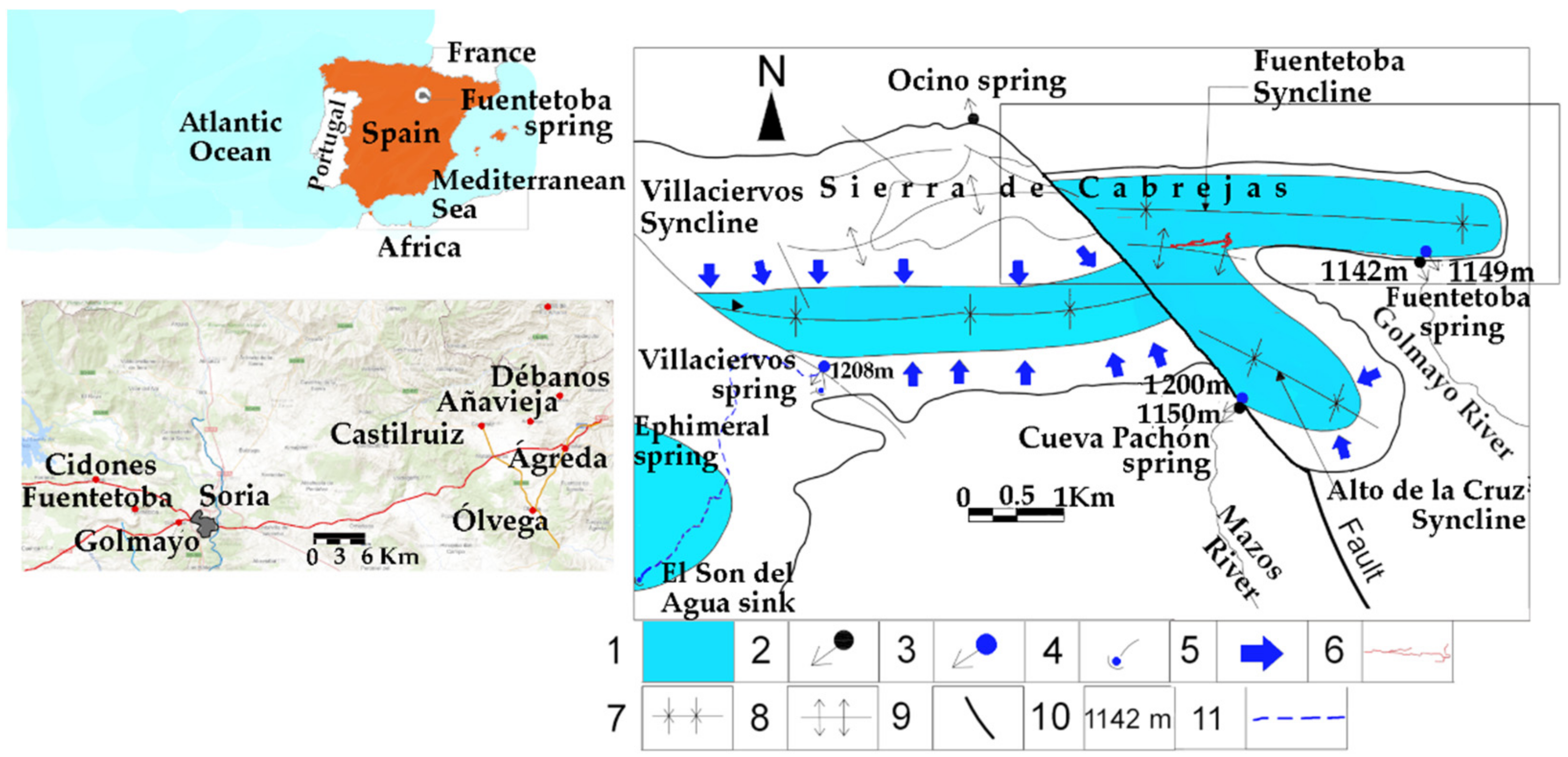
3. Area Description
3.1. Climate and Vegetation
3.2. External Geomorphological Characteristics
3.3. The Karstic System
4. Results
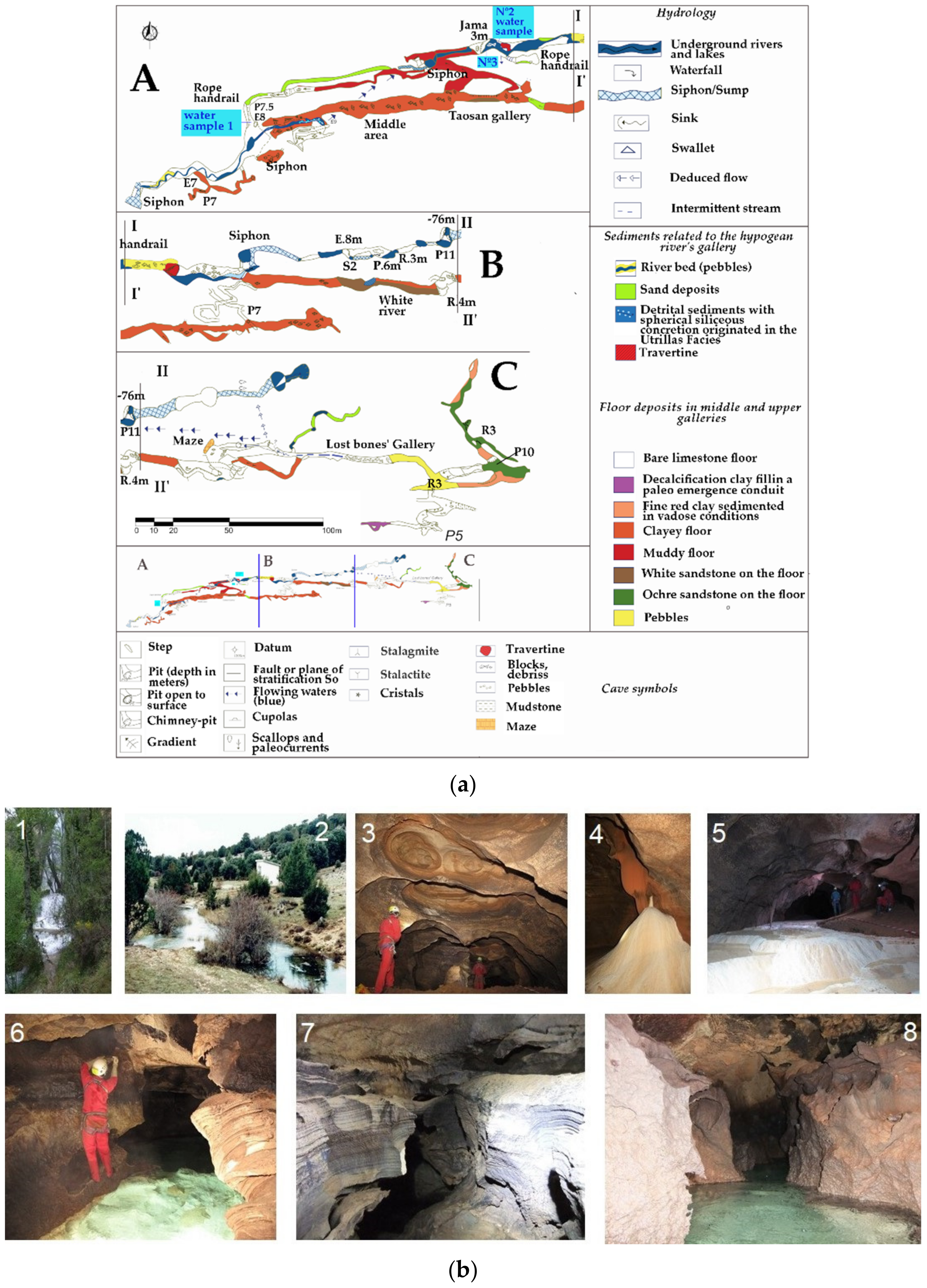
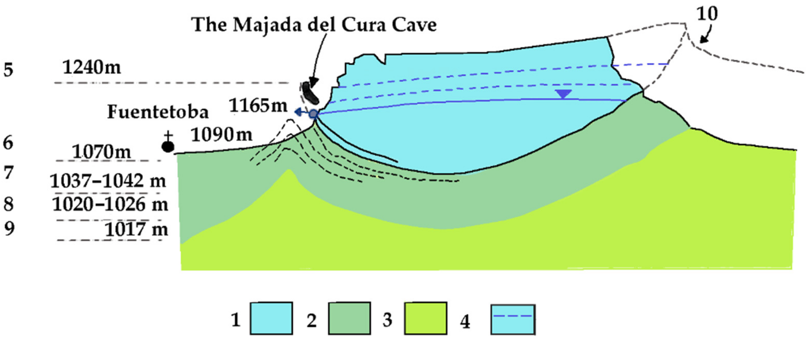
4.1. Paleohydrogeological Information Provided by the Endokarst: The Majada del Cura Cave and Fuentetoba Spring’s Trop-Plein Syphon
4.1.1. The Paleohydrological Information Provided by the Upper Galleries
4.1.2. The Paleohydrological Information Provided by the Active Lower Gallery
4.1.3. Syngenetic Cave Galleries: Fuentetoba Spring Syphon
4.2. External Morphology with a Paleogeographic Significance: The Fossil Superficial Drainage Network
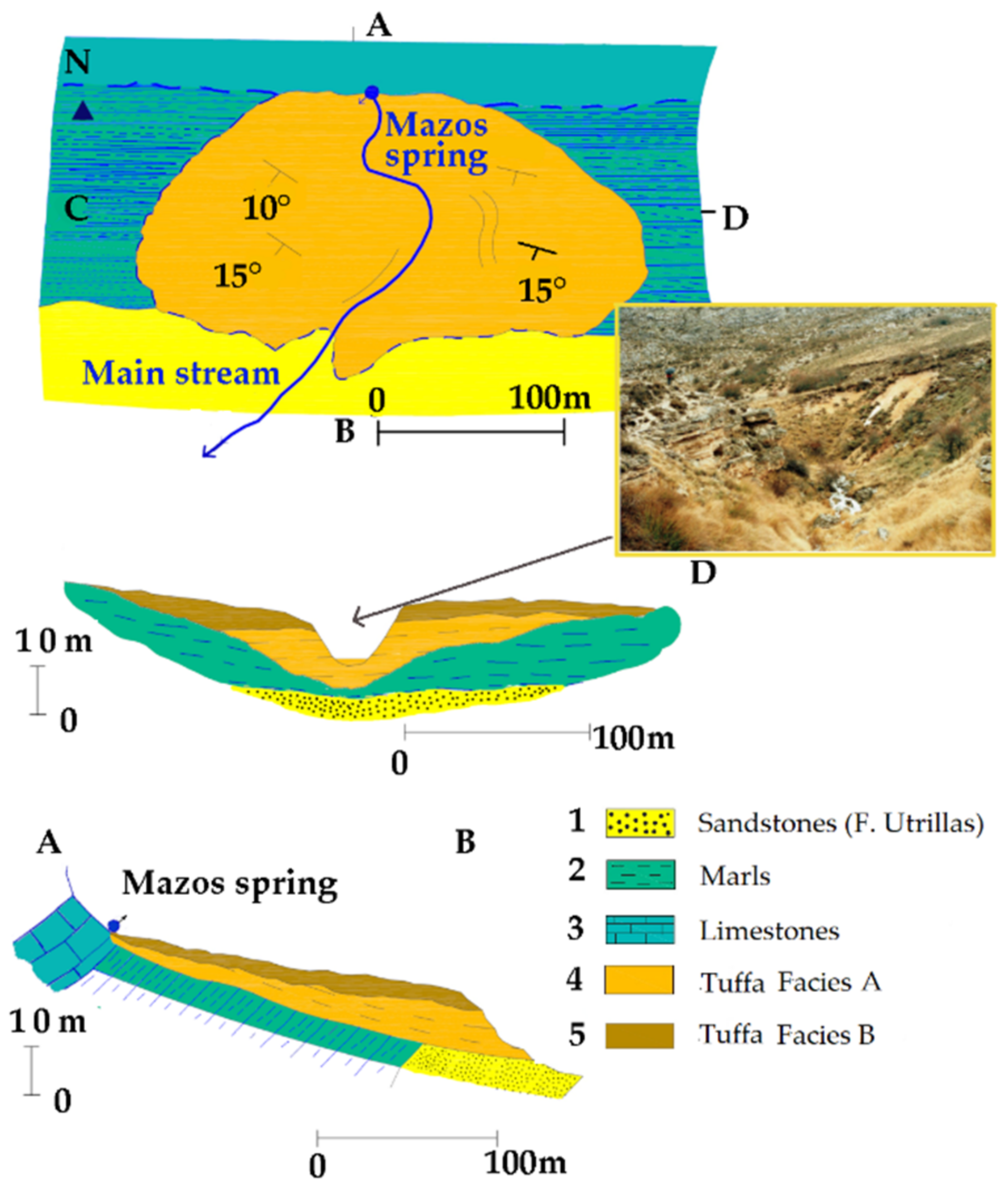
4.3. The Spring’s Calcareous Tufas
4.3.1. Geological Context
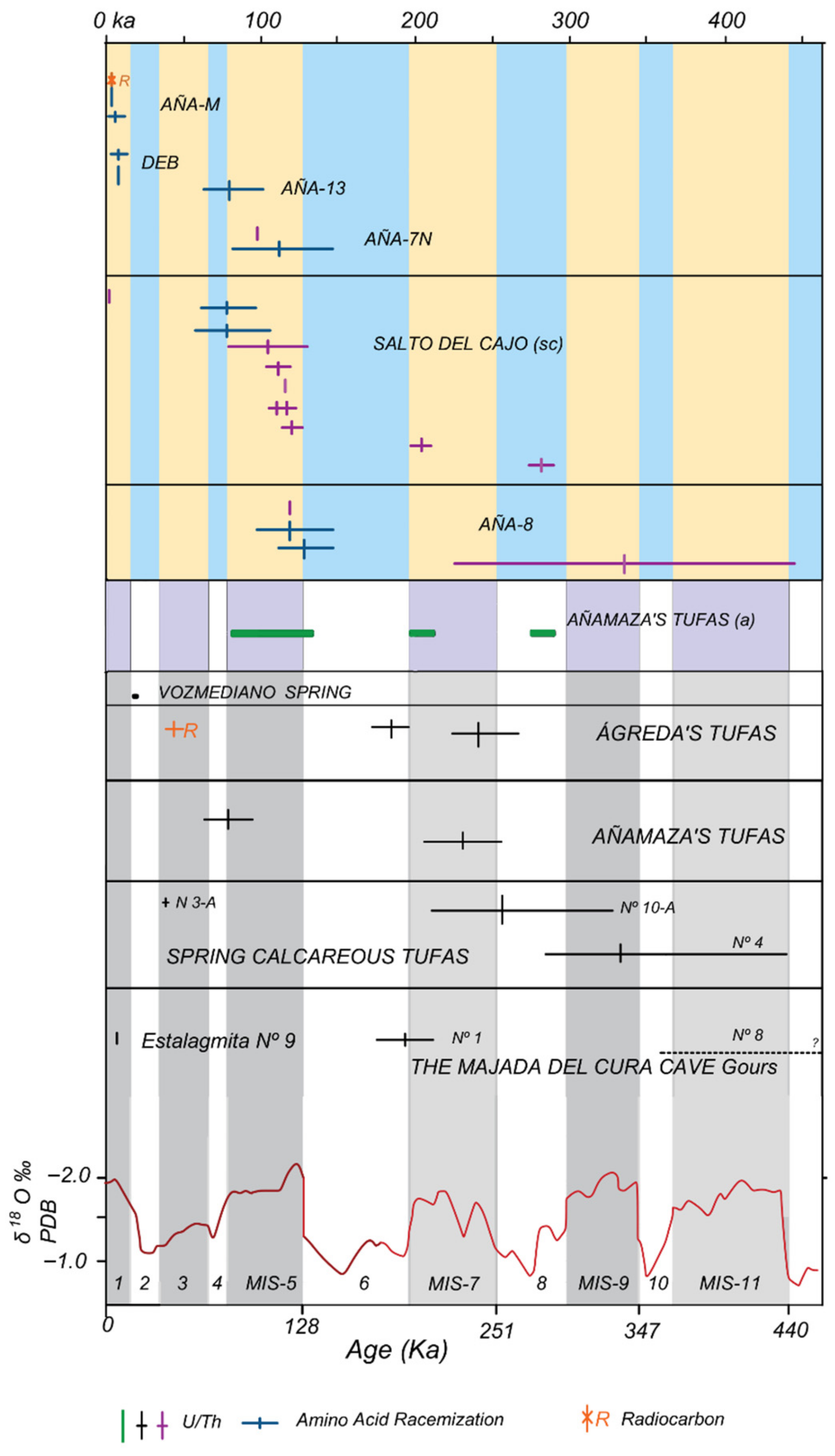
4.3.2. Dating of Tufas and Speleothems (Paleogours)
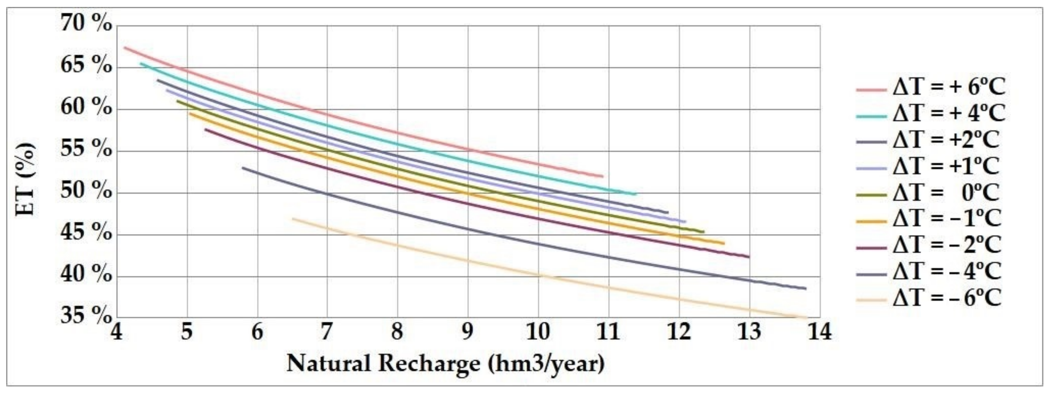
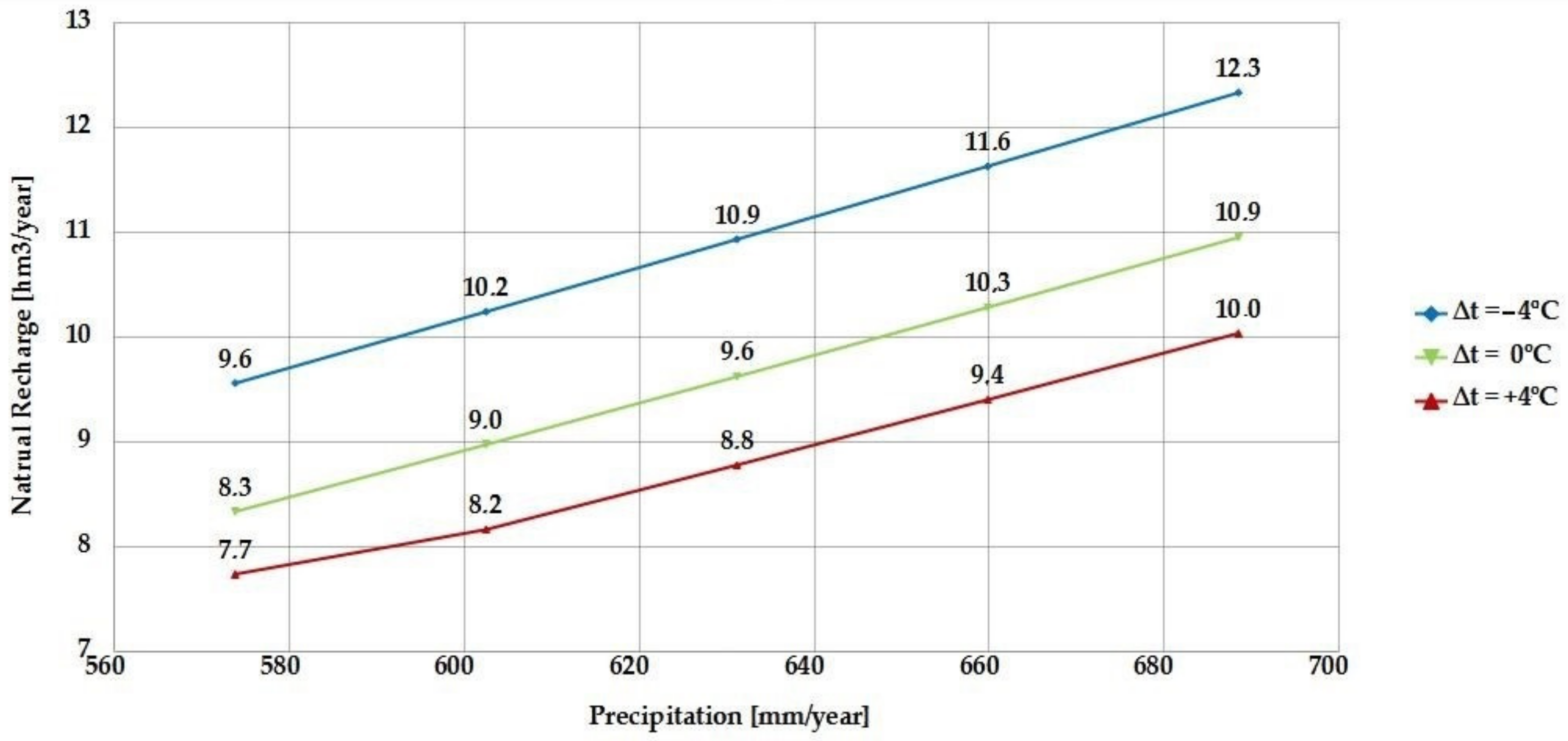
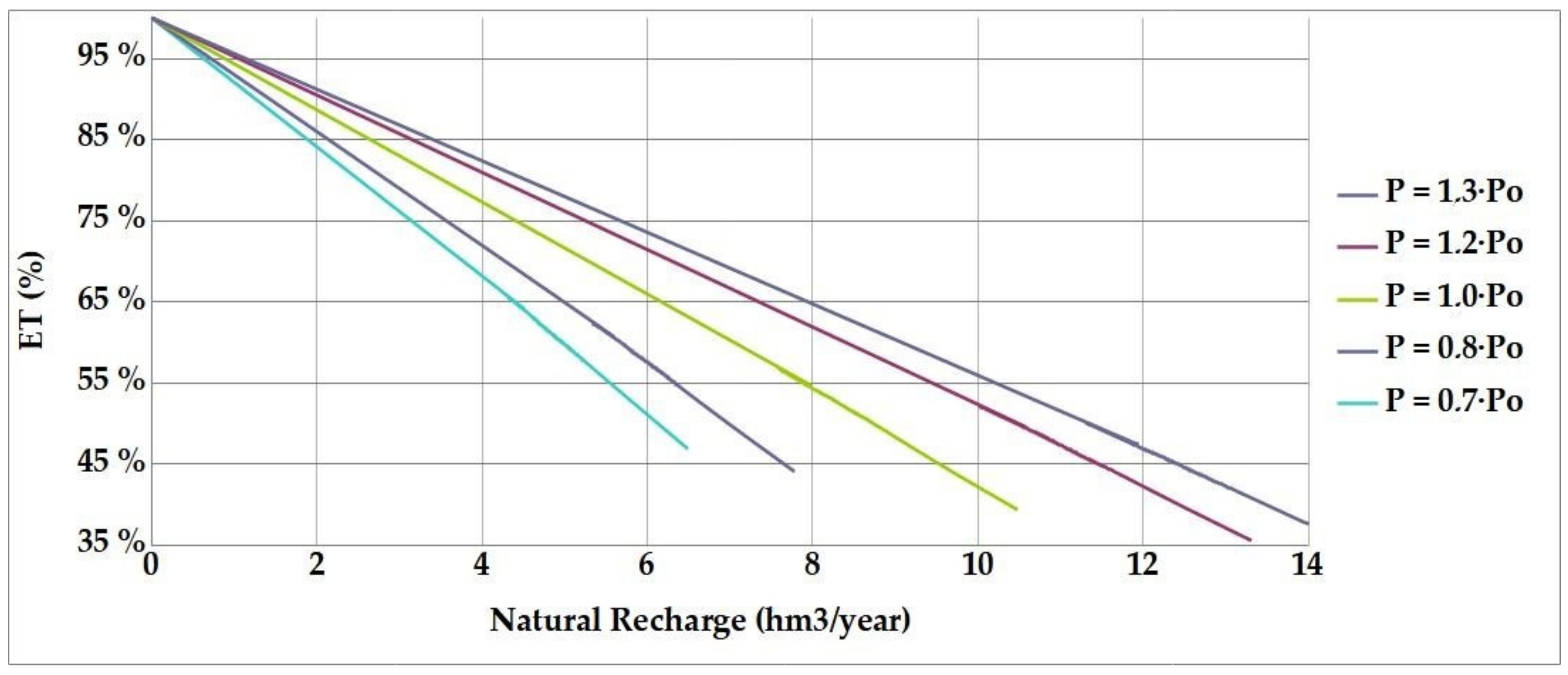
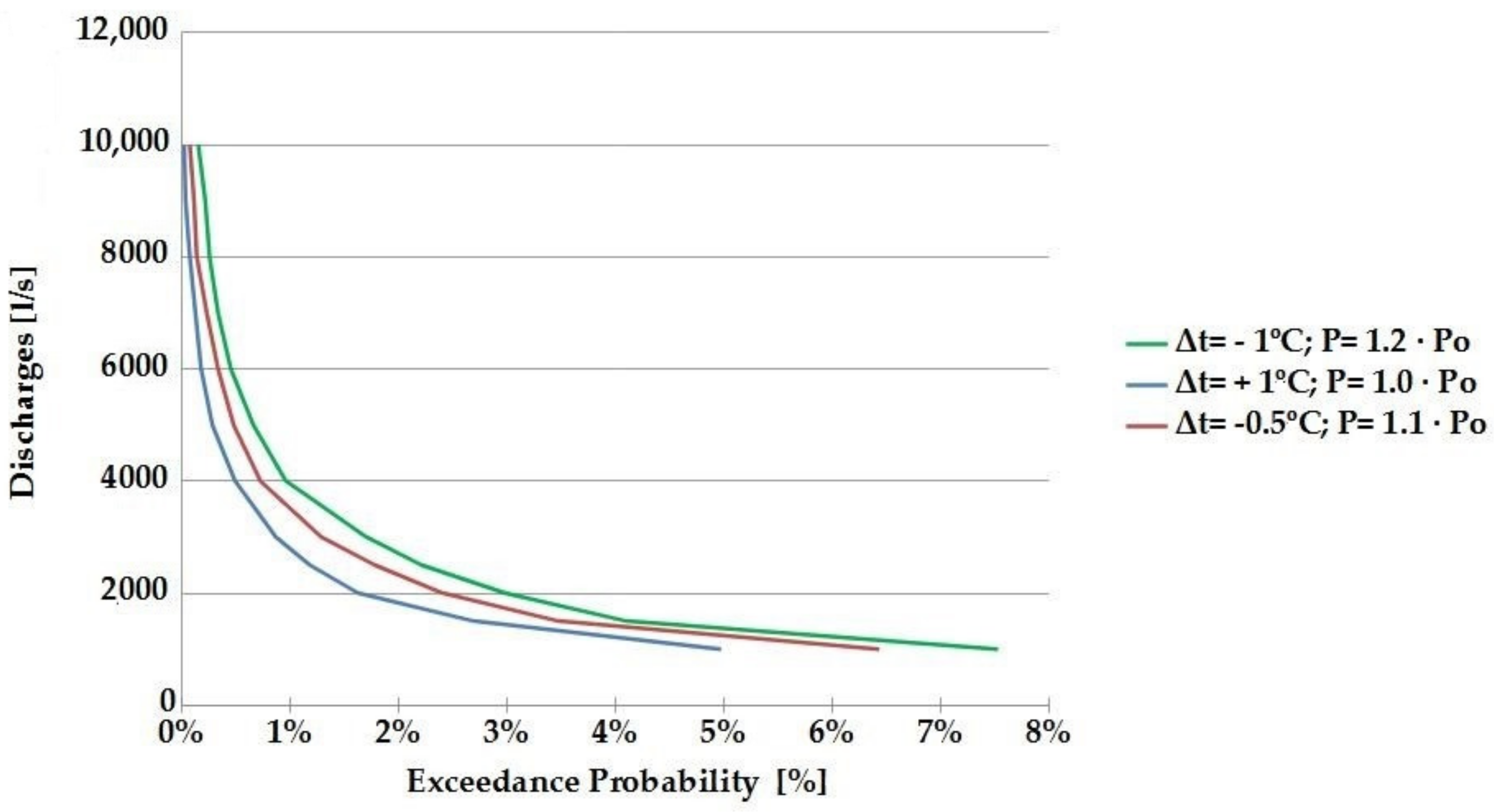
4.4. Paleohydrogeology and Natural Recharge in Past Climates: Recharge Variation versus Precipitation and Temperature Using Numerical Simulation
4.4.1. Limits in the Use of Mathematical Models for Calculating Past Natural Recharge
4.4.2. Modeling Results
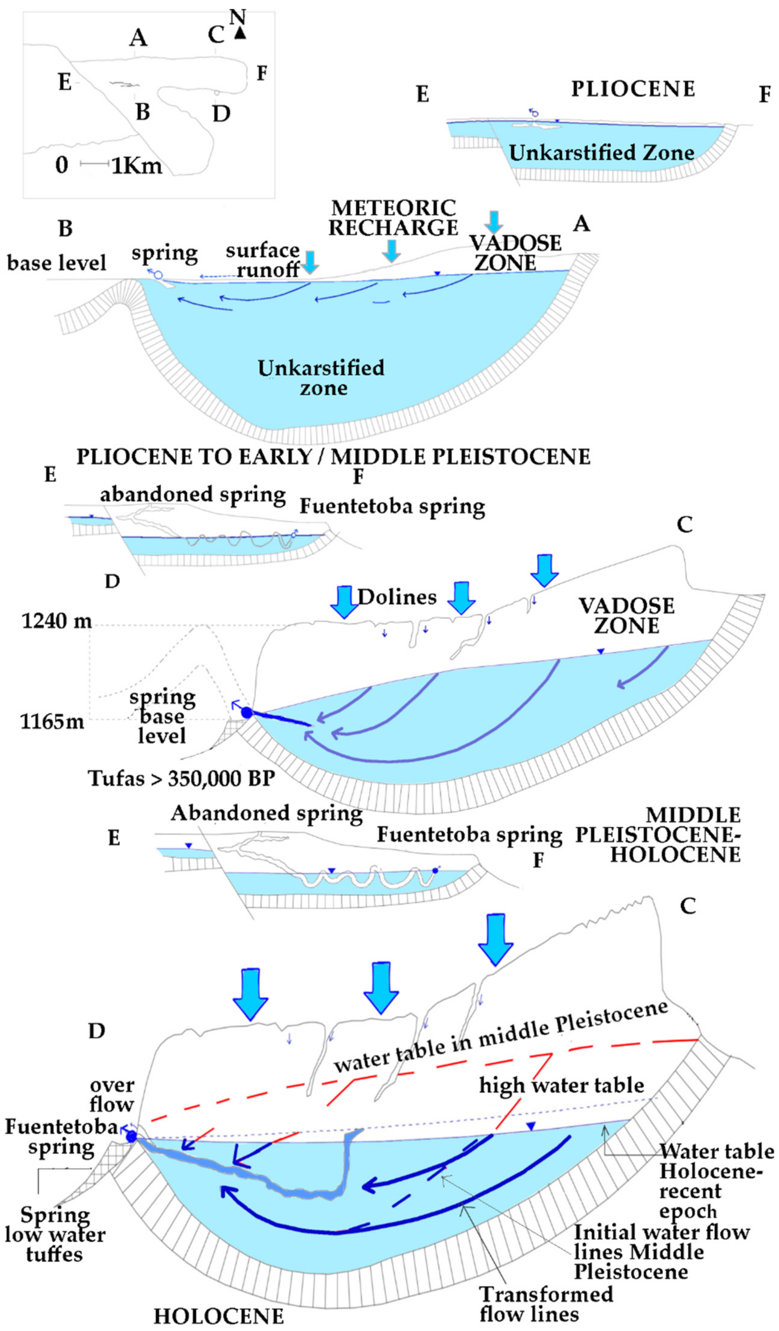
5. Discussion: Paleohydrological Evolution of the Karstic System during the Late Miocene and Quaternary
5.1. The Earliest Stages of Karstification in the Aquifer
5.2. Paleohydrologic Evolution Proposed Since the Late Miocene and during the Quaternary
5.3. What the Tufas Reveal about the Paleoclimatology of the Middle–Upper Pleistocene
5.4. Natural Recharge Variations in Earlier Climatic Stages
6. Conclusions
Author Contributions
Funding
Institutional Review Board Statement
Informed Consent Statement
Data Availability Statement
Acknowledgments
Conflicts of Interest
References
- Sanz, E.; Rosas, P.; Menéndez-Pidal, I.; De Ojeda, J.S. Modeling and Prefeasibility Management, and Conservation Strategies for Fuentetoba Springs, (Spain). Sustainability 2020, 12, 131. [Google Scholar] [CrossRef]
- Ford, D.C.; Williams, P.W. Karst Geomorphology and Hydrology; Unwin Hyman: London, UK, 1989; p. 601. [Google Scholar]
- Ford, D.C.; Williams, P.W. Karst Hydrogeology and Geomorphology; Wiley: Chichester, UK, 2007. [Google Scholar]
- Bakalowicz, M. Karst groundwater: A challenge for new resources. Hydrogeol. J. 2005, 13, 148–160. [Google Scholar] [CrossRef]
- Hernanz, A. Aspectos Generales de la Hidrología del Karst. Curso de Hidrología General y Aplicada. Escuela de Hi-drología; Centro de Estudios Hidrográficos: Madrid, Spain, 1979; p. 29. [Google Scholar]
- Renault, P. Contribution a l’etude des actions mecaniques et sedimentologiques dans la speleogenese. Ann. Speleol. 1967, 22, 259–307. [Google Scholar]
- Renault, P. La Formation des Cavernes. Presses Universitaires de France, Collection Que-sais-je, 1400, Paris, 1970; 126p. Available online: https://journals.openedition.org/geomorphologie/9547 (accessed on 23 June 2021).
- Klimchouk, A.B.; Ford, D.C.; Palmer, A.N.; Dreybrodt, W. (Eds.) Speleogenesis: Evolution of Karst Aquifers: Hunts-Ville, Ala; National Speleological Society Huntsville: Huntsville, AL, USA, 2000; p. 527. [Google Scholar]
- Rhoades, R.; Sinacori, M.N. Pattern of Ground-Water Flow and Solution. J. Geol. 1941, 49, 785–794. [Google Scholar] [CrossRef]
- Bakalowicz, M. Géochimie des eaux karstiques et karstification. (Karst groundwater geochemistry and karstification). Ann. Spéléologie 1975, 30, 581–589. [Google Scholar]
- Atkinson, T.C. Diffuse flow and conduit flow in limestone terrain in the Mendip-Hills, Somerset (Great Bretain). J. Hydrol. 1977, 35, 93–110. [Google Scholar] [CrossRef]
- Dreybrodt, W. Limestone Dissolution Rates in Karst Environments; Bulletin d’Hydrogéologie; Centre d’Hydrogéologie, Université de Neuchâtel, France: Neuchatel, Switzerland, 1998; Volume 16, pp. 167–183. [Google Scholar]
- Andrews, J.E. Paleoclimatic records from stable isotopes in reverine tufas: Synthesis and review. Earth Sci. Rev. 2006, 75, 85–104. [Google Scholar] [CrossRef]
- Gonzalez Martin, J.A.; Gonzalez Amuchastegui, J. (Eds.) Las acumulaciones tobaceas. Sociedad Española de Geomorfologia. Las Tobas en España. SEG, Badajoz. 2014, pp. 3–18. Available online: https://geomorfologia.es/publicaciones/libros (accessed on 23 June 2021).
- Peña, J.L.; Sancho, C.; Arenas, C.; Auque, L.; Longares, L.A.; Lozano, M.V.; Melendez, A.; Osacar, C.; Pardo, G.; Vazquez Urbez, M. Las tobas Cuaternarias en el Sector Aragonés de la Cordillera Iberica. Sociedad Española de Geomorfologia. Las Tobas en España. SEG, Badajoz. González Martín, J.A., González Amuchastegui, M.J., Eds.; 2014, pp. 159–172. Available online: https://geomorfologia.es/publicaciones/libros (accessed on 23 June 2021).
- Swanson, S.K.; Muldoon, M.; Polyak, V.; Asmerom, Y. Evaluating shallow flow-system response to climate change through analysis of spring deposits in southwsetern Wisconsin, USA. Hydrogeol. J. 2014, 22, 851–863. [Google Scholar] [CrossRef]
- Sanz, E.; Rosas, P.; Menéndez-Pidal, I. Hidrogeología del Karst de Pico Frentes (Cordillera Ibérica, España). Estud. Geológicos 2016, 72, e047. [Google Scholar] [CrossRef] [Green Version]
- Arenas, C.; Sancho, C.; Vazquez-Urbel, M.; Pardo, G.; Hellstrom, J.; Ortiz, J.E.; Torres, T.; Cinta Osácar, M.; Auqué, L. Las tobas cuaternarias del río Añamaza (provincia de Soria, Cordillera Ibérica): Aproximación cronológica. Geogaceta 2010, 49, 51–54. [Google Scholar]
- Hellstrom, J. Atomic Spectrometry. J. Analytical. 2003, 18, 1346–1351. [Google Scholar]
- Sanz, E.; Rosas, P.; Menendez-Pidal, I. Drainage and siphoning of a karstic spring: A case study. J. Cave Karst Stud. 2016, 78, 183–197. [Google Scholar] [CrossRef]
- Fonolla, C.; Sanz, E.; Menendez-Pidal, I. Lateral ferruginous groundwater transfer as the origin of the iron crusts in caves: A case study. J. Cave Karst Stud. 2020, 82, 183–197. [Google Scholar] [CrossRef]
- Benito-Calvo, A.; Pérez-González, A. Erosion surfaces and Neogene landscape evolution in the NE Duero Basin (north-central Spain). Geomorphology 2007, 88, 226–241. [Google Scholar] [CrossRef]
- Rodríguez-García, J.A. Geomorfología de un Sector de la Cuenca de Almazán (Soria): Procesos de Erosión de Suelos y Planteamiento de Escenarios Ante el Cambio Climático. Ph.D. Thesis, Univ. Complutense de Madrid, Madrid, Spain, 2008; p. 390. [Google Scholar]
- IGME (Instituto Geológico y Minero de España). Mapa Geológico de España 1: 200.000. Hoja 31. Soria. Ed. IGME, Madrid, España. 1980. Available online: http://info.igme.es/cartografiadigital/portada/default.aspx?mensaje=true (accessed on 23 June 2021).
- Sanz, E. El Relieve de la Sierra de Cabrejas. III Congreso Geológico de España y I Congreso Iberoamericano de Geología. Salamanca, Spain Tomo 3. 1992, pp. 91–95. Available online: https://soporte.dialnet.unirioja.es/portal/es/kb/articles/acceso-a-documentos-a-texto-completo (accessed on 23 June 2021).
- IGME (Instituto Geológico y Minero de España). Mapa Geológico de España 1: 50.000. Hoja 349. Cabrejas del Pinar.. Ed. IGME, Madrid, España. 1982. Available online: http://info.igme.es/cartografiadigital/portada/default.aspx?mensaje=true (accessed on 23 June 2021).
- Pérez, J.; Sanz, E. Hydrodinamic characteristics and sustainable use of karst aquifer of high environmental value in the Cabrejas range (Soria, Spain). Environ. Earth Sci. 2010, 1, 20–30. [Google Scholar] [CrossRef]
- Sanz Perez, E. Las Aguas Subterraneas en Soria. Ediciones Diputación Provincial de Soria. Coleccion Temas Sorianos nº 39 Soria, España. 1999. Available online: https://scholar.google.es/scholar?hl=es&as_sdt=0%2C5&q=+Sanz+Perez%2C+E.1999.+Las+aguas+subterraneas+en+Soria.Ediciones+Diputaci%C3%B3n+Provincial+de+Soria.&btnG= (accessed on 23 June 2021).
- Shackleton, N.J.; Opdyke, N.D. Oxygen isotope and palaeomagnetic stratigraphy of Equatorial Pacific core V28-238: Oxygen isotope temperatures and ice volumes on a 105 year and 106 year scale. Quat. Res. 1973, 3, 39–55. Available online: https://www.sciencedirect.com/science/article/pii/0033589473900525 (accessed on 23 June 2021). [CrossRef]
- Sanz-Pérez, E.; Pascual, C.; de Ojeda, L.S.; Menéndez-Pidal, I. La antigua laguna de Agreda. Celtiberia 2015, 109, 177–191. [Google Scholar]
- Sanz, E.; Pidal, I.M.; Escavy, J.; Ojeda, J. Hydrogeological Changes along a Fault Zone Caused by Earthquakes in the Moncayo Massif (Iberian Chain, Spain). Sustainability 2020, 12, 9034. [Google Scholar] [CrossRef]
- Rushton, K.; Ward, C. The estimation of groundwater recharge. J. Hydrol. 1979, 41, 345–361. [Google Scholar] [CrossRef]
- Sanz, E.; Pérez, J.; Menéndez-Pidal, I.; Meneses, J.M.; Molina, C.Y. Guía Geológica de la Sierra de Cabrejas y del Mo-Numento Natural de la Fuentona. Exma. Diputación Provincial de Soria, Soria, España. 150 págs. 2012. Available online: https://scholar.google.es/scholar (accessed on 23 June 2021).
- Catastro del Marques de la Ensenada 1749–1759. Available online: http://pares.mcu.es/Catastro/servlets/ServletController?accion=4&opcionV=2 (accessed on 23 June 2021).
- Alcalde Olivares, M.C.; Gómez Manzaneque, F.; Postigo Mijarra, J.M.; Sanz Pérez, E.; Menéndez-Pidal, I. Pinus sylvestris L. en el Pleistoceno superior del Duero (Vega Cintora, Soria, España). Cuatern. Geomorfol. 2003, 17, 21–28. [Google Scholar]
- Menéndez Amor, J. Análisis Palinológico de los Yacimientos Turbosos de Calatañazor (Soria). Estudios Geológicos, 31. 795–797. CSIC, Madrid, España. 1975. Available online: https://pascal-francis.inist.fr/vibad/index.php?action=getRecordDetail&idt=PASCALGEODEBRGM7720087532 (accessed on 23 June 2021).
- De Vaumas, E. Phénomènes Karstiques en Méditerranée Orientel; Ed. Rueda: Madrid, Spain, 1967; Volume 4, pp. 193–281. [Google Scholar]
- Gutiérrez, M.; Peña, J.L. Cordillera Ibérica. En: Geomorfología de España. Ed. Rueda; Geoforma Ediciones: Madrid, Spain, 1994; pp. 251–286. [Google Scholar]
- Sese Benito, C. Mamíferos del Mioceno Medio de Escobosa de Calatañazor (Soria). Tesis Doctoral. Universidad Com-Plutense de Madrid. (Inédita). 1985. Available online: https://www.proquest.com/docview/1835821442?pq-origsite=gscholar&fromopenview=true (accessed on 23 June 2021).
- Monné, J.P. Geoarqueología aplicada a la reconstrucción paleoambiental: La evolución del Holoceno superior en el NE de España. Bol. Geol. Min. 2018, 1129, 285–303. [Google Scholar] [CrossRef]
- Curl, R.L. Scallops and flutes.Transactions of the Cave. Res. Group Great Br. 1996, 7, 121–160. Available online: http://www.eauxsouterraines.eu/documents/articlessciences/Curl_1966.pdf (accessed on 23 June 2021).
- Soligo, M.; Tuccimei, P.; Barberi, R.; Delitala, M.; Miccadei, E.; Taddeucci, A. U/Th dating of freshwater travertine from Middle Velino Valley (Central Italy): Paleoclimatic and geological implications. Palaeogeogr. Palaeoclim. Palaeoecol. 2002, 184, 147–161. [Google Scholar] [CrossRef]
- Julian Andres, A.; Chueca Cia, J. Le Petit Âge Glaciaire Dans les Pyrénées Centrales Méridionales: Estimations des Paléotempératures à Partir D’inférences Géomorphologiques. Revue Géographique des Pyrénées et du Sud-Ouest. Sud-Ouest Européen, 3 ppp. 1998, pp. 79–88. Available online: https://www.persee.fr/doc/rgpso_1276-4930_1998_num_3_1_2697 (accessed on 23 June 2021).
- Kresic, N.; Stevanovic, Z. Groundwater Hydrology of Springs: Engineering, Theory, Management, and Sustainability; Elsevier: Amsterdam, The Netherlands, 2010; p. 573. [Google Scholar]
- White, W.B. Conceptual Models for Karstic Aquifers: Speleogenesis and Evolution of Karst Aquifers, v.1. p. 11–16. Proceedings of the Symposium Held February 24 through 27, 1999 Charlottesville, Virginia. Edited by Arthur N. Palmer, Margaret V. Palmer, and Ira D. Sasowsky. Karst Modelling, Karst Water Institute Special Publications. 2003. Available online: https://apps.dtic.mil/sti/pdfs/ADA369937.pdf#page=19 (accessed on 23 June 2021).
- Sáenz, C. Pico Frentes (Partes I a V). Celtiberia 1955, 9, 245–274. [Google Scholar]
- Sáenz, C. La Fuente de La Toba y la Hidrología Local. Proyecto de Conducción de Aguas Potables de La Toba a Soria. Mapas y Anejos; Unpublished Report; Ayuntamiento de Soria: Soria, Spain, 1935; p. 59. Available online: https://scholar.google.es/scholar?hl=es&as_sdt=0%2C5&q=+Curl%2CR.L.%281966%29.+Scallops+and+flutes.Transactions+of+the+Cave.+Research+Group+of+Great+Britain%2C+7+%282%29%2C+121-60.&btnG= (accessed on 23 June 2021).


| Place | Name | Nominal Date (Years bp) | Method |
|---|---|---|---|
| The Majada del Cura Cave | N1 Middle Gour | 188,808 + 17,060/−14,853 | Th-230/U-234 |
| N2 Bones (c) | ― | ― | |
| N7 Clay (c) | ― | ― | |
| N8 High Gour | 350 | Th-230/U-234 | |
| N 9 Stalagmite | 6978 + 568/−565 | Th-230/U-234 | |
| Spring’s tufa | N4 La Monjía | 335,683 + 98,854/−52,534 | Th-230/U-234 |
| 3-A Mazos River (a) | 38,858 + 1660/−1635 | Th-230/U-234 | |
| N 10-A Fuentetoba (b) | 252,304 + 70,511/−42,615 | Th-230/U-234 | |
| N 11-B Pachón Cave (c) | ― | ― | |
| Añamaza’s tufa | 1 | 225,000 + 25,000/−20,000 | U/Th |
| 2 | 75,000 + 12,500/−12,500 | U/Th | |
| Ágreda’s tufa | Dam | 240,034 + 19,920/−16,963 | U/Th |
| Railway station | 180,108 + 9365/−8754 | U/Th | |
| Keyles River | 40,350 ± 1950 | C-14 | |
| Calcareous tufa terrace | Vozmediano spring | 19,159 + 947/−950 | Th-230/U-234 |
| P = 130% | P = 120% | P = 100% | P = 80% | P = 70% | |||||||||||
|---|---|---|---|---|---|---|---|---|---|---|---|---|---|---|---|
| EVT (%) | R(hm3) | días > 1.000 l/s | EVT (%) | R(hm3) | días > 1.000 l/s | EVT (%) | R(hm3) | días > 1.000 l/s | EVT (%) | R(hm3) | días > 1.000 l/s | EVT (%) | R(hm3) | días > 1.000 l/s | |
| ∆T = −6° | 34.0% | 14.77 | 35.0 | 35.6% | 13.31 | 32.0 | 39.4% | 10.48 | 24.5 | 44.1% | 7.78 | 17.4 | 46.9% | 6.49 | 13.8 |
| ∆T = −4° | 38.5% | 13.81 | 32.5 | 40.3% | 12.38 | 29.4 | 44.5% | 9.62 | 22.8 | 49.8% | 7.01 | 14.6 | 53.0% | 5.78 | 10.1 |
| ∆T = −2° | 42.3% | 13.00 | 31.3 | 44.3% | 11.61 | 28 | 48.8% | 8.93 | 20.6 | 54.3% | 6.42 | 12.4 | 57.6% | 5.25 | 8.5 |
| ∆T = −1° | 43.9% | 12.65 | 30.1 | 45.9% | 11.28 | 27.5 | 50.6% | 8.64 | 19.3 | 56.2% | 6.18 | 12 | 59.5% | 5.03 | 8 |
| ∆T = 0° | 45.3% | 12.36 | 29.3 | 47.3% | 11.01 | 26.7 | 52.0% | 8.4 | 18.5 | 57.7% | 5.98 | 11.3 | 61.0% | 4.85 | 7 |
| ∆T = +1° | 46.5% | 12.10 | 29 | 48.6% | 10.76 | 25.8 | 53.3% | 8.19 | 18.2 | 59.0% | 5.8 | 11 | 62.3% | 4.7 | 7.4 |
| ∆T = +2° | 47.6% | 11.85 | 29.2 | 49.7% | 10.53 | 25.9 | 54.4% | 7.99 | 17.8 | 60.2% | 5.65 | 10.5 | 63.5% | 4.57 | 6.8 |
| ∆T = +4° | 49.8% | 11.39 | 28.3 | 51.8% | 10.1 | 25.1 | 56.6% | 7.63 | 17 | 62.2% | 5.37 | 10.1 | 65.5% | 4.33 | 7.9 |
| ∆T = +6° | 51.9% | 10.92 | 27.2 | 54.0% | 9.66 | 23.5 | 58.7% | 7.28 | 16.2 | 64.3% | 5.09 | 9.6 | 67.4% | 4.1 | 6.0 |
Publisher’s Note: MDPI stays neutral with regard to jurisdictional claims in published maps and institutional affiliations. |
© 2021 by the authors. Licensee MDPI, Basel, Switzerland. This article is an open access article distributed under the terms and conditions of the Creative Commons Attribution (CC BY) license (https://creativecommons.org/licenses/by/4.0/).
Share and Cite
Sanz Pérez, E.; Fonolla, C.; Menéndez Pidal, I.; Rosas Rodriguez, P. Paleohydrogeology of the Karstic System of Fuentetoba Spring (Soria, Spain): An Interdisciplinary Approach. Sustainability 2021, 13, 7236. https://doi.org/10.3390/su13137236
Sanz Pérez E, Fonolla C, Menéndez Pidal I, Rosas Rodriguez P. Paleohydrogeology of the Karstic System of Fuentetoba Spring (Soria, Spain): An Interdisciplinary Approach. Sustainability. 2021; 13(13):7236. https://doi.org/10.3390/su13137236
Chicago/Turabian StyleSanz Pérez, Eugenio, Cristina Fonolla, Ignacio Menéndez Pidal, and Pablo Rosas Rodriguez. 2021. "Paleohydrogeology of the Karstic System of Fuentetoba Spring (Soria, Spain): An Interdisciplinary Approach" Sustainability 13, no. 13: 7236. https://doi.org/10.3390/su13137236