Article

Research on the Spatial Network Characteristics and Synergetic Abatement Effect of the Carbon Emissions in Beijing–Tianjin–Hebei Urban Agglomeration

1
College of Management and Economics, Tianjin University, Tianjin 300072, China
2
Research Center for Circular Economy and Enterprise Sustainable Development, Tianjin University of Technology, Tianjin 300384, China
*
Author to whom correspondence should be addressed.
Sustainability 2019, 11(5), 1444; https://doi.org/10.3390/su11051444
Submission received: 23 January 2019 / Revised: 4 March 2019 / Accepted: 5 March 2019 / Published: 8 March 2019

Abstract

:
Based on the carbon emission data in the Beijing–Tianjin–Hebei urban agglomeration from 2007 to 2016, this paper used the method of social network analysis (SNA) to investigate the spatial correlation network structure of the carbon emission. Then, by constructing the synergetic abatement effect model, we calculated the synergetic abatement effect in the cities and we empirically examined the influence of the spatial network characteristics on the synergetic abatement effect. The results show that the network density first increased from 0.205 in 2007 to 0.263 in 2014 and then decreased to 0.205 in 2016; the network hierarchy fluctuated around 0.710, and the minimum value of the network efficiency was 0.561, which indicates that the network hierarchy structure is stern and the network has good stability. Beijing and Tianjin are in the center of the carbon emission spatial network and play important “intermediary” and “bridge” roles that can have better control over other carbon emission spatial spillover relations between the cities, thus the spatial network of carbon emissions presents a typical “center–periphery” structure. The synergetic abatement effect increased from −2.449 in 2007 to 0.800 in 2011 and then decreased to −1.653 in 2016; the average synergetic effect was −0.550. This means that the overall synergetic level has a lot of room to grow. The carbon emission spatial network has a significant influence on the synergetic abatement effect, while increasing the network density and the network hierarchy. Decreasing the network efficiency will significantly enhance the synergetic abatement effect.

1. Introduction

With the carbon dioxide concentration in the atmosphere increasing, a series of problems, such as global warming, glacier melting, sea level rise, and so on, have been triggered, which pose a serious threat to the sustainable development of human society and the security of the ecology and the environment [1]. The signing of the Paris Agreement demonstrates the determination of the international community to actively cope with global climate change. The signatories agreed to control the average rise of the global temperature within less than 2 °C above the pre-industrial level and to strive to control the temperature rise within 1.5 °C above the pre-industrial level. However, the annual Greenhouse Gas Bulletin issued by the World Meteorological Organization in 2017 pointed out that the average level of carbon dioxide in 2016 was 145% of that of pre-industrialization, and the average concentration of carbon dioxide in the world reached 403.3 parts per million, which surpassed the historical record [2]. This shows that working to reduce greenhouse gas emissions, mainly composed of carbon dioxide, and promote the coordinated development of the socio-economic and ecological environment are still major issues that need to be solved urgently in all countries of the world.
As the largest developing country in the world, China has become one of the largest carbon emitters [3,4]. How to deal with this contradiction between development and the environment in China has always been a global focus [5]. In order to solve this problem, the government of China is committed to achieving the goal of cutting carbon-emitting intensity by 40–45% before 2020 and plans to reach the peak of carbon emissions around 2030. Because of the vast territory of China and the differences in the development level of each region, natural resources endowment, and geographical environment [6], it is difficult for all regions to achieve the low-carbon development goals formulated by the state in the same way [7]. Therefore, finding a coordinated development path in terms of economy, society, and the ecological environment that is suitable for China’s national conditions is the major premise for achieving the goal of carbon emission reduction. In fact, China is currently implementing a series of regional and spatial development strategies, such as the synergetic development of Beijing, Tianjin, and Hebei and the construction of the Yangtze River Economic Zone [8]. The spatial correlation of carbon emissions has broken through the traditional linear model and is gradually presenting a nonlinear spatial structure with complex network structure characteristics. Thus, in order to adhere to green and low-carbon development, it is an important policy for China to establish a new mechanism of regionally coordinated development with urban agglomerations as the main body [9]. Against this background, this paper chose the Beijing–Tianjin–Hebei urban agglomeration as the research area, focusing on the spatial network characteristics of carbon dioxide emissions and the synergetic emission reduction effect. Based on the relational data and network analysis perspective, this took the spatial correlation of carbon emissions as the breakthrough point, analyzing the spatial network structure and the effect of its carbon emissions with the help of the social network analysis method. This aimed at formulating emission reduction policies that are more in line with regional characteristics in the implementation of a regional coordinated development strategy in China, as well as providing a reference and basis for achieving synergetic emission reduction among regional cities.

2. Literature Review

Carbon emissions have always been a hot issue in academic research and also a key issue in regional socio-economic development. Early studies focused on the relationship between carbon emissions and economic development [10,11] and systematically explored the principles and mechanisms of carbon emission reduction [12,13]. On this basis, scholars at home and abroad have made great research achievements regarding carbon-emission intensity [14], carbon emission performance [15], carbon emission quota [16], and factors affecting carbon emissions [17]. According to recent studies, the spatial effects of carbon emissions have become an important research subject. Many scholars use exploratory spatial data analysis (ESDA) to examine the characteristics of the spatial correlation and spatial agglomeration of carbon emissions at the regional level. Grunewald et al. explored the driving factors for the formation of spatial differences in carbon emissions and found that energy intensity and energy structure were the main reasons for these spatial differences [18]. Marbuah and Mensah took 290 urban districts in Sweden as research areas. Statistical tests were carried out to analyze the spatial correlation of several pollutants, including carbon dioxide. The results showed that the spatial spillover effect was the main driving factor of the environmental Kuznets curve [19]. Through spatial econometrics, Wu studied the temporal and spatial pattern and evolution mechanism of carbon emission reduction in different provinces of China and analyzed the emission reduction characteristics of key provinces [20]. Wang et al. constructed spatial econometric models, which were based on patent data about energy conservation and emission reduction and economic externalities of spatial units that were transplanted into CO2 emissions research [21]. Yan et al. used the undesirable-slacks-based measure (SBM) model and evaluated the carbon emission efficiency [22]. You et al. applied the spatial panel method to address the problems of spatial dependency and the spillover effect among neighboring countries [23]. Sun et al. divided China into resource-based and non-resource-based areas according to their industrial development level. Using the equity measurement method, the dynamic differences of regional carbon emissions were discussed and the causes of profit-loss deviation were revealed [24]. Wang et al. estimated the spatial dependence of the carbon emission reduction potential at the provincial level, combined with the economic weight matrix and the novel spatial panel data model [25]. Zhang et al. used Arc GIS to calculate the carbon emission and absorption rates in China’s Beijing–Tianjin–Hebei agglomeration [26]. From the perspective of research methods, some studies used social network analysis (SNA) [27,28,29] to analyze the regional carbon emission spatial network structure. Most of the research on carbon emissions focuses on carbon emission measurement and decomposition, carbon emissions’ influencing factors, and carbon emission efficiency [30,31,32]. When using traditional spatial measurement methods to analyze carbon emissions and their influencing factors, most of the literature only considers geographically similar factors. An increasing number of researchers have proved that carbon emissions do not exist independently in various regions but in a certain spatial correlation. Existing research often considers the spatial correlation of carbon emissions from the perspective of provinces or regions and from the empirical study of “attribute data” of carbon emissions. They do not reveal the linkage structure between regions from the perspective of “relational data”. In addition, there are a few issues involved with the synergy effect of carbon emission reduction among regions and how to strengthen the synergy of regional emission reduction.
In summary, previous studies have thoroughly explored the issue of carbon emissions and revealed the spatial correlation characteristics and spatial differences of carbon emissions to a certain extent, which has laid the foundation for the study of regional synergetic carbon emission reduction. However, the “relational data” have more analytical value, as they often determine the performance of the “attribute data”. Therefore, on the basis of existing research, this paper uses the social network analysis method to comprehensively deconstruct the spatial network characteristics of carbon emissions in the urban agglomeration of Beijing, Tianjin, and Hebei, to analyze its synergetic emission reduction effect. On this basis, the proposal of synergetic carbon emission reduction in an urban agglomeration is put forward in order to understand the spatial correlation of carbon emissions as a whole and to reveal the interconnected network structure of carbon emissions among regions and its impact on synergetic carbon emission reduction. This can provide a decision-making reference for achieving the goal of coordinated regional carbon emission reduction and formulating corresponding carbon emission reduction policies.

3. Research Methods and Sources of Data

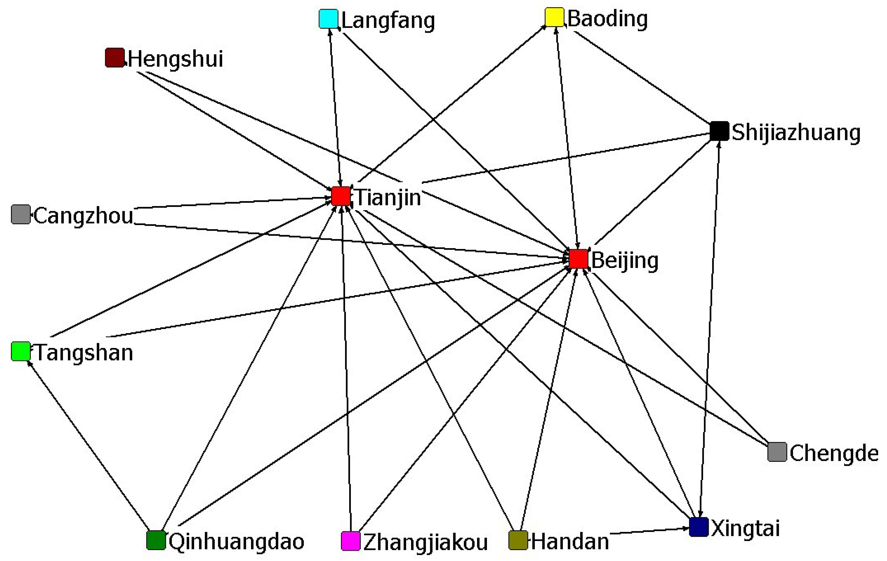
3.1. Construction of a Spatially Relevant Network of Carbon Emissions

Social network analysis is a quantitative analysis method for relational data, which has been widely used in sociology, economics, management, and other disciplines. It takes “relationship” as the basic unit of analysis and expresses the interaction among members as a pattern or rule based on the relationship by studying the network relationship. The confirmation of relationships is the key to the analysis of social networks. Currently, the methods of describing spatial correlation are mainly the Granger Causality test based on the VAR model and the gravitational model or the improved gravitational model [33,34,35,36]. This paper uses the improved gravity model to construct the spatial correlation network of carbon emissions in the urban agglomeration of Beijing–Tianjin–Hebei, as the VAR model is too sensitive to the selection of lag order, which would reduce the accuracy of the characterization of the network structure characteristics [37,38,39]. In addition, the gravitational model is not only applicable to the total data, but also can take economic and geographical factors into account. The basic model is:
G i j = C i C i + C j × P i C i E i 3 P j C j E j 3 ( D i j e i e j ) 2 .
In Formula (1), i and j indicate i city and j city in the urban agglomeration of Beijing–Tianjin–Hebei respectively; G i j indicates the carbon emission gravity between cities; C i and C j indicate the carbon emission of i city and j city, respectively; P i and P j indicate the total population of i city and j city, respectively; E i and E j indicate the gross product of i city and j city, respectively; D i j indicates the spatial distance between i city and j city; e i and e j indicate the per capita production of i city and j city, respectively. D i j e i e j Value means “economic distance” between i city and j city.
According to Formula (1), the gravitational matrix of carbon emissions of the urban agglomeration of Beijing–Tianjin–Hebei can be calculated, then the average value of each row of the gravitational matrix can be taken as the critical value. If the gravity is higher than the average value, then the value is taken as 1, which indicates that there is a correlation between the city in this row and the carbon emission of the city in this column. In contrast, if the gravity is lower than the average value, the value is taken as 0, indicating that there is no correlation between the two. Thus, the spatial correlation matrix of carbon emissions in the urban agglomeration of Beijing–Tianjin–Hebei can be constructed.

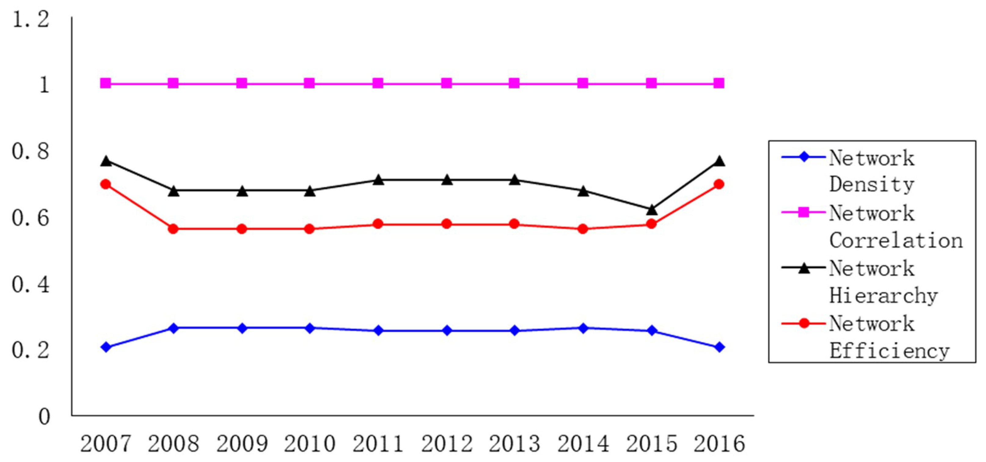
3.2. Characteristic Index of the Spatial Network of Carbon Emissions

In social network analysis, four indicators—network density, network correlation degree, network hierarchy, and network efficiency—are commonly used to reflect the overall characteristics of the network structure, while for the individual network structure characteristics, degree centrality and intermediary centrality are used to describe them [40,41].
For the structural characteristics of the entire network, if N is the number of urban nodes in the carbon emission network of the urban agglomeration of Beijing–Tianjin–Hebei, the largest number of possible correlations in the network is N × ( N 1 ) ; if the number of actual correlations in the network is M, the density of the network can be expressed as follows:
D n = M / [ N × ( N 1 ) ] .
Network density reflects the closeness of the entire network structure. The greater the network density, the closer the relationship between the carbon emissions of the cities in Beijing, Tianjin, and Hebei and the greater the impact of the network structure on the carbon emissions of the cities.
If the number of pairs of unreachable points in the network is V, the formula for calculating the degree of network correlation is as follows:
C = 1 V / [ N × ( N 1 ) / 2 ] .
The network correlation degree reflects the robustness and vulnerability of the spatial network of carbon emissions. The greater the network correlation degree, the greater the direct or indirect correlation between the cities in the spatial network of carbon emissions of the urban agglomeration of Beijing–Tianjin–Hebei.
If the number of pairs of symmetrically reachable points in the network is K, max ( K ) is the number of pairs of the most possible symmetrically reachable points in the network. Then, the hierarchy of the network can be expressed as:
H = 1 K / max ( K ) .
Network hierarchy describes the degree of asymmetric accessibility of cities in the network. The higher the network hierarchy, the stricter the hierarchical structure among the cities. Only a few cities are in the dominant position in the network.
If M is the number of redundant lines in the network, max ( M ) is the maximum possible number of redundant lines. The formula for calculating the network efficiency of the network is as follows:
E = 1 M / max ( M ) .
Network efficiency characterizes the connective efficiency between cities in the network. The lower the network efficiency, the more links that exist between cities in the network. Therefore, their carbon emissions are closely related, generating more channels of spatial spillover.
For the structural characteristics of the individual network, if d i is the number of direct correlations existing between i city and other cities in the carbon emission network of the urban agglomeration of Beijing–Tianjin–Hebei, then the degree of centrality of i city can be expressed as:
C d ( i ) = d ( i ) / ( N 1 ) .
Point-degree centrality measures the degree to which the cities of Beijing, Tianjin, and Hebei are at the center of the spatial correlation network of carbon emissions. The greater the degree of point centrality, the more the city is at the center of the network and the more connections it has with other cities.
If g j k is the number of relationship paths between j city and k city and g j k ( i ) is the number of cities to pass through the relationship paths between j city and k city, the formula for calculating the degree of intermediary centrality of cities is as follows:
C b ( i ) = 2 j < k [ g j k ( i ) / g j k ] ( N 1 ) ( N 2 ) .
The degree of intermediary centrality reflects the extent to which a city in the network can control the relationship between the other cities. The greater the degree of intermediary centrality, the stronger the “intermediary” role the city plays in the network, thus the greater the extent to which it can control the correlation of carbon emissions of other cities [42].

3.3. Synergetic Effect Model of Carbon Emission Reduction

Due to externalities, the problem of environmental pollution needs to be treated through regional coordination in order to make fundamental achievements. In the process of regional coordinated emission reduction, regions with higher economic development levels and lower pollution levels are regarded as learning examples for other regions [43]. If other regions can change the direction and extent of pollutant emission in the same direction as the benchmark areas, the benchmark effect of coordinated emission reduction will exist among the regions [44,45]. Considering this, this paper chose Beijing, the central city of the urban agglomeration of Beijing–Tianjin–Hebei, as the benchmark area of carbon emission reduction and used the methods of Cerqueira and Martins to construct the synergetic effect model of carbon emission reduction of the urban agglomeration of Beijing–Tianjin–Hebei [46].
C o r r b i , t = 1 1 2 [ ( c b , t c b ¯ ) 1 t 1 t ( c b , t c b ¯ ) 2 ( c i , t c i ¯ ) 1 t 1 t ( c i , t c i ¯ ) 2 ] 2
In Formula (8), C o r r b i , t shows the synergetic effect of carbon emission reduction of i city of the urban agglomeration of Beijing–Tianjin–Hebei for the year and the central city, Beijing. The closer the value is to 1, the higher the synergy between the i city and the central city, Beijing. c b , t indicates the total annual carbon emissions of Beijing for the t year and c b ¯ is the average annual carbon emissions of Beijing for the t year. c i , t indicates the total annual carbon emissions of i city in the urban agglomeration of Beijing–Tianjin–Hebei for the t year and c i ¯ shows the average annual carbon emissions of i city in the urban agglomeration of Beijing–Tianjin–Hebei.

3.4. Sources of Data

This paper takes 13 cities, including Beijing, Tianjin, Shijiazhuang, Chengde, Zhangjiakou, Qinhuangdao, Tangshan, Langfang, Baoding, Cangzhou, Hengshui, Xingtai, Handan, as the research objects. The research time ranges from 2007 to 2016—10 years in total. The data of economy, population, and energy consumption of each city come from the statistical annals of Chinese cities, the statistical annals of China’s energy resources, the statistical annals of Beijing, Tianjin, and Hebei, and the statistical annals and bulletins of Hebei cities in each year; these data are properly referred to.
Considering the lack of statistical data on carbon dioxide emissions at the urban level, this paper adopts the simplified estimation method of carbon dioxide emissions based on apparent energy consumption in the 2006 IPCC Guidelines for National Greenhouse Gas Inventories to calculate the carbon dioxide emissions of each city in the urban agglomeration of Beijing–Tianjin–Hebei. The calculation formula is as follows:
E c o 2 = i ( E i × V i × F i × O i ) × 44 12 ,
where E c o 2 is the total amount of carbon dioxide emissions generated by energy consumption, E i is the apparent consumption of the i energy, V i is the low calorific value of the i energy, F i is the carbon emission factor of the i energy, and O i is the oxidation rate of the energy. The conversion coefficient of   44 12 converts the carbon atom mass to the carbon dioxide molecular mass. Considering the availability of the data, this paper chooses several kinds of energy sources—coal, coke, crude oil, gasoline, kerosene, diesel, raw oil, liquefied petroleum gas, and natural gas—to calculate the carbon dioxide emissions of each city in the urban agglomeration of Beijing–Tianjin–Hebei [47,48,49,50]. Among them, the correlation coefficients of various energy sources are mainly derived from the data published in the 2006 IPCC Guidelines for National Greenhouse Gas Emissions Inventories.

4. Calculation Results and Analysis

4.1. Characteristic Analysis of the Spatial Network of Carbon Emissions

According to the improved gravity model of Formula (1) mentioned above, the carbon emission gravity matrix of the urban agglomeration of Beijing–Tianjin–Hebei is primarily calculated and converted into a spatial correlation matrix. In order to more effectively demonstrate the structure of the spatial correlation network of carbon emissions of the urban agglomeration of Beijing–Tianjin–Hebei, this paper draws a spatial correlation network of carbon emissions in 2016 by using the visualization tool Net-draw from the software UCINET6.0 ( UCINET v6.0, Analytic Technologies, Lexington, KY, USA). The specific results of the network are shown in Figure 1.
As is shown in Figure 1, the spatial correlation network of carbon emissions in the urban agglomeration of Beijing–Tianjin–Hebei takes on a typical “center–periphery” structure. There are 32 correlations among the 13 cities and there is at least one spatial correlation among each city, which indicates that the carbon emissions of each city are generally related in space, and the urban agglomeration of Beijing–Tianjin–Hebei has a relatively stable spatial network structure of carbon emissions.
In order to further investigate the spatial network characteristics of carbon emissions in the urban agglomeration of Beijing–Tianjin–Hebei, the network density, network correlation, network hierarchy, network efficiency, point degree centrality, and intermediary centrality were calculated based on Formula (2–7). The spatial network characteristics of carbon emissions of the urban agglomeration of Beijing–Tianjin–Hebei from 2007 to 2016 were analyzed from two aspects: The entire network’s characteristics and individual centrality. Firstly, the overall characteristics of the spatial network of carbon emissions in the urban agglomeration of Beijing–Tianjin–Hebei were calculated; the specific results are shown in Figure 2.
According to the results of Figure 2, the network density of the spatial network of carbon emissions in the urban agglomeration of Beijing–Tianjin–Hebei increased first and then decreased from 0.205 in 2007 to 0.263 in 2014, then to 0.205 in 2016. The increase of network density shows that the carbon emission links between the cities of Beijing, Tianjin, and Hebei are getting closer, but the network density has declined since 2014, which indicates that the spatial links of carbon emissions in the urban agglomeration of Beijing–Tianjin–Hebei have been reduced and it is imperative to enhance the coordinated emission reduction among the cities. On the other hand, the correlation degree of the spatial network of carbon emissions in the urban agglomeration of Beijing–Tianjin–Hebei over the years is 1, which indicates that the structure of the carbon emission network of the urban agglomeration of Beijing–Tianjin–Hebei is stable, there is general spatial correlation and spillover, and the network accessibility is good. From 2007 to 2016, the network hierarchy fluctuated around 0.710, which indicates that, in the spatial network of carbon emissions, the hierarchical structure between the cities of Beijing, Tianjin, and Hebei is stricter and only a few cities are in the center of the network. The network efficiency shows an oscillatory trend, with a minimum value of 0.561 and a maximum value of 0.697. The value of the comprehensive network efficiency is relatively high, which indicates that there are more redundant connections in the network and there are many overlaps in the spatial spillover of carbon emissions. This also means that the existing network correlation can maintain the stability of the network. The results indicate that the carbon emission spatial correlation is increasingly close in the urban agglomeration. This result may have originated from China, which put forward the goal of energy conservation and emission reduction starting in 2006. The carbon emission spatial correlation was enhanced as the adjustment of the energy and industrial structure, the energy flow, and the industrial transfer among the cities were gradually increased.
To compare with the existing research [27,28,29] on China’s provincial carbon emission spatial network, our analysis shows that in the process of China’s current urban agglomeration development, there also exists a stable and complex carbon emission spatial network structure and correlation relationship among the cities in the urban agglomeration. The difference is that, in the national carbon emission spatial network, the network hierarchical structure is gradually broken and an increasing number of small provinces have changed the subordinate and edge positions in the network. However, as the results show in Figure 2, the large cities are still in the center position and have the control status. In other words, under the influence of the carbon emission spatial network, in order to improve the carbon emission reduction efficiency of the urban agglomeration, the small cities in Hebei province also need to take actions to change the subordinate and edge positions in the network. Only focusing on the emission reduction measures of the large cities, such as Beijing and Tianjin, will not produce a long-term mechanism for the realization of the regional emission reduction goals.
Furthermore, according to Formula (6,7), two indices of each city in the urban agglomeration of Beijing–Tianjin–Hebei—point degree centrality and intermediary degree—are calculated. Individual centrality of the carbon emission network in the urban agglomeration of Beijing–Tianjin–Hebei is analyzed but, due to the limitation of the length of the paper, only the calculation results of 2016 are given, as shown in Table 1.
From the results of Table 1, we can see that only three of the 13 cities, Tianjin, Beijing, and Baoding, in the urban agglomeration of Beijing–Tianjin–Hebei have a higher point-in degree than point-out degree. They belong to the recipient subject in the spatial network correlation of carbon emissions, while the other ten cities have a higher point-out degree than point-in degree, belonging to the spillover subject in the spatial network correlation of carbon emissions. From the results of the point-degree centrality, the point-degree centrality of Beijing and Tianjin is up to 91.667, which is obviously higher than that of other cities. This shows that Beijing and Tianjin are in the central position in the carbon emission network and have more links with other cities. The cities with a relatively small degree of centrality tend to send out a carbon emission correlation to the cities with a larger degree of centrality. In terms of the intermediary centrality, Tianjin and Beijing still ranked in the first two places, with 15.404 and 7.071, respectively. The results of the other cities are far lower than those of Tianjin and Beijing. It can be seen that Beijing and Tianjin, which lie in the center of the network, also play an important role of “intermediary” and “bridge” in the spatial network of carbon emissions, while the other cities are in a weaker position in the network. This is mainly because, as the two core cities in the urban agglomeration of Beijing–Tianjin–Hebei and compared to the cities of Hebei Province, Beijing and Tianjin have benefited in terms of economic development, industrial structure, energy consumption, and so on. This reveals that there is a significant carbon emission spatial transfer trend from energy-rich cities to economically developed cities in China. Therefore, synergetic promotion of inter-city carbon emission control will be the key work of the coordinated development of Beijing, Tianjin, and Hebei in the future [51,52]. It is essential to analyze the synergetic emission reduction effect in the urban agglomeration of Beijing–Tianjin–Hebei on the basis of clarifying the characteristics of the spatial network of carbon emissions in Beijing, Tianjin, and Hebei.

4.2. Analysis of the Synergetic Effect of Carbon Emission Reduction

Based on the synergetic effect model of Formula (8) mentioned above, choosing Beijing as the learning benchmark, the synergetic effect of carbon emission reduction in the urban agglomeration of Beijing–Tianjin–Hebei was calculated from 2007 to 2016. The specific results are shown in Table 2.
Based on the results of Table 2, the closer the value is to 1, the higher the synergy between the related city and the central city, Beijing. We can see that the synergetic effect of carbon emission reduction in the urban agglomeration of Beijing–Tianjin–Hebei shows a trend of rising first and then declining. The average level of synergetic effect increased from −2.449 in 2007 to 0.800 in 2011, and then decreased to −1.653 in 2016. This is mainly because Beijing, as the national political, cultural, and technological innovation center, has been capable of controlling its carbon emissions within a reasonable level for a long time, while other cities in the urban agglomeration of Beijing, Tianjin, and Hebei are in the process of industrialization and urbanization and the level of carbon emissions in all other regions shows a trend of continuous growth [9]. With the improvement of economic ties, the interests of related cities and Beijing are more closely linked. If a city continues to follow the original development path of high pollution and high emission, Beijing, which has a larger economic volume, can respond by reducing the purchase of polluting products, thus forcing the city to follow the benchmark of Beijing in terms of their production mode. In the past ten years, the average synergetic effect in the urban agglomeration of Beijing–Tianjin–Hebei was −0.550. There is still much room to improve the overall synergetic level. From the perspective of each city, the synergetic effect of carbon emission reduction is significant. The synergetic effect of carbon emission reduction between Tianjin, Shijiazhuang, Tangshan, Baoding, Xingtai, and other cities and Beijing is relatively high. With the further promotion of a coordinated development strategy of Beijing, Tianjin, and Hebei, a crucial mission in the future will be to change the economic development mode of high investment, high consumption, and high emission and to establish an effective mechanism of coordinated emission reduction through relieving the non-capital functions of Beijing and upgrading the industrial transfer in Beijing.
As mentioned above, structural data usually determine the performance of the attribute data. Based on a clear description of the spatial network of carbon emissions in the urban agglomeration of Beijing–Tianjin–Hebei and an in-depth analysis of the synergetic emission reduction effect in the urban agglomeration of Beijing, Tianjin, and Hebei, this paper chose the annual average of the synergetic emission reduction effect from 2007 to 2016 in the Beijing–Tianjin–Hebei urban agglomeration as the explained variable, respectively, and chose the network intensity, network hierarchy, and network efficiency from 2007 to 2016 as the explanatory variables. We carried out the ordinary least square (OLS) regression, aiming to reveal the impact of the overall structure of the spatial network on the synergetic emission reduction effect. The regression results are shown in Table 3.
According to the results of Table 3, the regression coefficients of network density, network hierarchy, and network efficiency of the spatial correlation of carbon emissions in the urban agglomeration of Beijing–Tianjin–Hebei are 31.809, −10.283, and −13.613, respectively, which indicate that the spatial network of carbon emissions has a significant impact on the synergetic effect of carbon emission reduction. The increase in network density and the decrease in network hierarchy and network efficiency will significantly strengthen the synergetic effect of carbon emission reduction. This is mainly because the increase in network density means that the number of relationships in the whole network will increase, which will help to limit and narrow the spatial differences of carbon emissions among cities in the network. The decline of the network hierarchy will gradually break down the strict hierarchical structure among cities in the network, and the former subordinate and marginal cities will have more discourse power. Additionally, the decline in network efficiency shows the increase of links in the spatial network of carbon emissions, which will eliminate the comparative advantages of some cities in the network in terms of carbon emissions and in turn increase the synergetic effect of carbon emission reduction.

5. Conclusions and Policy Implications

5.1. Main Conclusions

Based on the data of 13 cities in the urban agglomeration of Beijing–Tianjin–Hebei from 2007 to 2014, this paper adopted the improved gravitational model to characterize the spatial correlation of carbon emissions in the urban agglomeration of Beijing–Tianjin–Hebei. On this basis, the spatial characteristics of the carbon emission network in the urban agglomeration of Beijing–Tianjin–Hebei were investigated by using the analysis method of the social network. Then, a synergetic effect model of carbon emission reduction was constructed to analyze the synergetic emission reduction in the urban agglomeration of Beijing–Tianjin–Hebei. The main conclusions are as follows:
(1) During the research, the spatial correlation network of carbon emissions in the urban agglomeration of Beijing–Tianjin–Hebei presented a typical “center–periphery” structure. From the overall structure of the network, the network density showed a trend of first rising and then declining and the spatial relationship of carbon emissions in the urban agglomeration of Beijing–Tianjin–Hebei still needs strengthening. The results of the network correlation degree show that the network accessibility in the urban agglomeration of Beijing–Tianjin–Hebei is in good condition; the results of the network hierarchy show that in the spatial network of carbon emissions, the hierarchical structure among the cities of Beijing, Tianjin, and Hebei is stricter. Network efficiency showed an oscillating trend, and its value was generally higher. These results indicate that the spatial correlation of carbon emissions has broken through the traditional geographical limitation, showing a complex multi-threaded spatial network correlation, with many overlapping phenomena in the spatial spillover of carbon emissions. The spatial correlation network structure of carbon emissions in the urban agglomeration has gradually stabilized.
(2) Based on the characteristics of network individual centrality, only three of the 13 cities, Tianjin, Beijing, and Baoding, in the urban agglomeration of Beijing–Tianjin–Hebei belong to the recipient subject in the spatial network correlation of carbon emissions. Beijing and Tianjin are in the center position of the network in the spatial network of carbon emissions. They also play an important role of “intermediary” and “bridge”, while other cities are weaker in the spatial network of carbon emissions.
(3) During the research, the synergetic effect of carbon emission reduction in the urban agglomeration of Beijing–Tianjin–Hebei showed a trend of rising first and then declining. The average value of the synergetic effect of carbon emission reduction in the urban agglomeration of Beijing–Tianjin–Hebei was −0.550 over the past ten years. There is still much room to improve the overall synergetic level. From the perspective of each city, the differences in terms of the synergetic effect of carbon emission reduction were quite obvious. The synergetic effect of carbon emission reduction between Tianjin, Shijiazhuang, Tangshan, Baoding, Xingtai, etc., and Beijing was relatively high.
(4) The spatial network of carbon emissions has a significant impact on the synergetic effect of carbon emission reduction. The increase in network density and the decrease in network hierarchy and network efficiency will greatly enhance the synergetic effect of carbon emission reduction. Therefore, enhancing the network structure of spatial correlation of carbon emissions in the urban agglomeration of Beijing–Tianjin–Hebei is an important driving mechanism to narrow the spatial differences of carbon emissions, improve the spatial equity of carbon emissions, and promote the coordinated emission reduction in these regions.
This paper has made a comprehensive analysis and research on the spatial network characteristics and synergetic abatement effect of the carbon emissions in Beijing–Tianjin–Hebei Urban Agglomeration. While we have obtained some research results, and they are of a certain theoretical and practical significance, due to the limitations of personal research ability, there may be still some deficiencies in the paper. Firstly, considering the availability and computability of the data, we only selected the primary energy consumption to calculate the carbon emissions, in the future, we will consider adding more energy consumption data, such as the electricity energy into the formula to improve the carbon emissions calculation. On the other hand, the confirmation of relationships is the key to the analysis of social networks. Currently, this paper uses the improved gravity model to construct the spatial correlation network of carbon emissions in the urban agglomeration of Beijing–Tianjin–Hebei. Whether there will be more advanced methods to determine the network relationships is worth exploring.

5.2. Policy Implications

With the further development of major regional development strategies such as the coordinated development of Beijing, Tianjin, and Hebei, as well as the construction of the Yangtze River Economic Zone, it is an inevitable choice to establish a coordinated mechanism for carbon emission reduction across these regions for the realization of national low-carbon development goals in the future. Comprehensive analysis of the spatial characteristics of carbon emissions and the synergetic emission reduction effects in the urban agglomeration of Beijing–Tianjin–Hebei can provide solutions for the cities in the Beijing, Tianjin, and Hebei provinces to formulate emission reduction policies based on their piratical conditions in the process of synergetic development, in order to achieve the goal of regional synergetic carbon emission reduction [7,53].
Through the research conclusions mentioned above, we can extract the following inspiration for making policies: First, according to the structural characteristics of the “center–periphery” structure of the spatial network of carbon emissions in the urban agglomeration of Beijing–Tianjin–Hebei, we can establish a “lead–follow” type of synergetic emission reduction mechanism. In this type of mechanism, Beijing and Tianjin are the overall leading areas of carbon emission reduction in the urban agglomeration of Beijing–Tianjin–Hebei, while other cities act as the following areas of carbon emission reduction to promote the synergetic control on carbon emission reduction [54]. Secondly, the above research shows that it is difficult to achieve the long-term mechanism of carbon emission reduction by only improving the carbon emission reduction targets of each individual city. It is an inevitable choice to establish a transregional carbon emission reduction coordination mechanism to achieve future carbon emission reduction goals. Thus, we should continuously adjust and optimize the spatial network structure of carbon emissions. At the same time, we should strictly control the total amount of carbon dioxide emissions from the perspective of spatial relations and attach more importance to improving the efficiency of the spatial allocation of resources by using market mechanisms, further boosting the trial establishment of the trading of carbon-emission rights in Beijing and Tianjin, and taking the cities in Hebei province into the scope of trading [1,3]. Finally, we should accelerate the coordinated development strategy of Beijing, Tianjin, and Hebei, establishing the regional sharing mechanism of emission reduction responsibility and the system of emission reduction compensation as soon as possible [55]. While ensuring the economic growth of underdeveloped cities, we should promote the convergence of the level of carbon emissions with the central city, Beijing, enhancing the synergetic effect of carbon emission reduction.

Author Contributions

All authors contributed equally to this work. Specifically, X.L. developed the original idea for the study and designed the methodology. D.F. completed the survey and drafted the manuscript, which was revised by J.L. and Z.Z. All authors read and approved the final manuscript.

Funding

This research was funded by: The National Social Science Foundation of China, Research on the Generating Mechanism Evaluation Method and Governance Model of the Political Cost of Environmental Pollution Problem, No. 16BGL138; the Key Projects of Philosophy and Social Science in Ministry of Education, Study on Some Major Issues in the Implementation of the Beijing–Tianjin–Hebei Synergetic Development Strategy, No. 15JZD021.

Conflicts of Interest

The authors declare no conflict of interest.

References

  1. Li, W.; Wang, W.; Wang, Y.; Ali, M. Historical growth in total factor carbon productivity of the Chinese industry—A comprehensive analysis. J. Clean. Prod. 2018, 170, 471–485. [Google Scholar] [CrossRef]
  2. People.cn. Greenhouse Gas Bulletin: Global Carbon Dioxide Concentrations Hit a New High in 2016. Available online: http://world.people.com.cn/n1/2017/1031/c1002-29618565.html (accessed on 15 December 2018).
  3. Tan, X.; Dong, L.; Chen, D.; Gu, B.; Zeng, Y. China’s regional CO2 emissions reduction potential: A study of Chongqing city. Appl. Energy 2016, 162, 1345–1354. [Google Scholar] [CrossRef]
  4. IEA. CO2 Emissions from Fuel Combustion 2013; IEA: Paris, France, 2014. [Google Scholar]
  5. Chen, J.D.; Cheng, S.L.; Nikic, V.; Song, M.L. Quo Vadis? Major players in global coal consumption and emissions reduction. Transform. Bus. Econ. 2018, 17, 112–132. [Google Scholar]
  6. Zhao, Q.R.; Chen, Q.H.; Xiao, Y.T.; Tian, G.Q.; Chu, X.L.; Liu, Q.M. Saving forests through development? Fuelwood consumption and the energy-ladder hypothesis in rural Southern China. Transform. Bus. Econ. 2017, 16, 199–219. [Google Scholar]
  7. Zhang, C.; Lin, Y. Panel estimation for urbanization energy consumption and CO2 emissions: A regional analysis in China. Energy Policy 2012, 49, 488–498. [Google Scholar] [CrossRef]
  8. Zhuang, M.; Sheng, J.C.; Webber, M.; Baležentis, T.; Geng, Y.; Zhou, W. Measuring water use performance in the cities along China’s South-North water transfer project. Appl. Geogr. 2018, 98, 184–200. [Google Scholar]
  9. Zhu, Z.; Liu, Y.; Tian, X.; Wang, Y.; Zhang, Y. CO2 emissions from the industrialization and urbanization processes in the manufacturing center Tianjin in China. J. Clean. Prod. 2017, 168, 867–875. [Google Scholar] [CrossRef]
  10. Yamaji, K.; Matsuhashi, R.; Nagata, Y.; Kaya, Y. A study on economic measures for CO2 reduction in Japan. Energy Policy 1993, 21, 123–132. [Google Scholar] [CrossRef]
  11. Ang, B.W. Is the energy intensity being a less useful indicator than the carbon factor in the study of climate change? Energy Policy 1999, 27, 943–946. [Google Scholar] [CrossRef]
  12. Bohm, P.; Larsen, B. Fairness in a tradable permit treaty for carbon emission reductions in Europe and the former Soviet Union. Environ. Resour. Econ. 1994, 4, 219–239. [Google Scholar] [CrossRef]
  13. Janssen, M.; Rotmans, J. Allocation of fossil CO2 emission rights quantifying cultural perspectives. Ecol. Econ. 1995, 13, 65–79. [Google Scholar] [CrossRef]
  14. Zhao, G.M.; Zhao, G.Q.; Chen, L.Z.; Sun, H.P. Research on spatial and temporal evolution of carbon emission intensity and its transition mechanism. China Popul. Resour. Environ. 2017, 27, 84–93. (In Chinese) [Google Scholar]
  15. Jiang, J.J.; Ye, B.; Xie, D.J.; Tang, J. Provincial-level carbon emission drivers and emission reduction strategies in China: Combining multi-layer LMDI decomposition with hierarchical clustering. J. Clean. Prod. 2017, 169, 178–190. [Google Scholar] [CrossRef]
  16. Jorgenson, A.; Schor, J. Income Inequality and Carbon Emissions in the United States: A State-level Analysis, 1997–2012. Ecol. Econ. 2017, 134, 40–48. [Google Scholar] [CrossRef]
  17. Zhao, R.; Min, N.; Gen, Y. Allocation of carbon emissions among industries/sectors: Emissions intensity reduction constrained approach. J. Clean. Prod. 2017, 142, 3083–3094. [Google Scholar] [CrossRef]
  18. Grunewald, N.; Jakob, M.; Mouratiadou, I. Decomposing inequality in CO2 emissions: The role of primary energy carriers and economic sectors. Ecol. Econ. 2014, 100, 183–194. [Google Scholar] [CrossRef]
  19. Marbuah, G.; Amuakwa-Mensah, F. Spatial analysis of emissions in Sweden. Energy Econ. 2017, 68, 383–394. [Google Scholar] [CrossRef]
  20. Wu, H. Analysis on Chinese Provincial Carbon Emission Reduction: Spatial-temporal Patterns, Evolution Mechanisms and Policy Recommendations: Based on the Theory and Method of Spatial Econometrics. Manag. World 2015, 11, 3–10. (In Chinese) [Google Scholar]
  21. Wang, B.; Sun, Y.F.; Wang, Z.H. Agglomeration effect of CO2 emissions and emissions reduction effect of technology: A spatial econometric perspective based on China’s province-level data. J. Clean. Prod. 2018, 204, 96–106. [Google Scholar] [CrossRef]
  22. Yan, D.; Lei, Y.L.; Li, L.; Song, W. Carbon emission efficiency and spatial clustering analyses in China’s thermal power industry: Evidence from the provincial level. J. Clean. Prod. 2017, 156, 518–527. [Google Scholar] [CrossRef]
  23. You, W.H.; Lv, Z.K. Spillover effects of economic globalization on CO2 emissions: A spatial panel approach. Energy Econ. 2018, 73, 248–257. [Google Scholar] [CrossRef]
  24. Sun, H.; Liu, Y. Analysis on inter-regional differences of carbon emissions loss and profit deviation in China. Manag. Rrev. 2016, 10, 89–96. (In Chinese) [Google Scholar]
  25. Wang, Y.; Zhao, T.; Wang, J.; Guo, F.; Kan, X.; Yuan, R. Spatial analysis on carbon emission abatement capacity at provincial level in China from 1997 to 2014: An empirical study based on SDM model. Atmos. Pollut. Res. 2019, 10, 97–104. [Google Scholar] [CrossRef]
  26. Zhang, Y.; Wua, Q.; Zhao, X.; Hao, Y.; Liu, R.; Yang, Z.; Lu, Z. Study of carbon metabolic processes and their spatial distribution in the Beijing-Tianjin-Hebei urban agglomeration. Sci. Total Environ. 2018, 7, 1630–1642. [Google Scholar] [CrossRef] [PubMed]
  27. Wang, F.; Gao, M.N.; Liu, J.; Fan, W.N. The spatial network structure of China’s regional carbon emissions and its network effect. Energies 2018, 11, 2076. [Google Scholar] [CrossRef]
  28. Sun, Y.; Liu, H.; Liu, C. Research on spatial association of provinces carbon emissions and its effects in China. Shanghai Econ. Res. 2016, 2, 82–92. (In Chinese) [Google Scholar]
  29. Yang, G.Y.; Wu, Q.; Xu, Y. Researches of China’s regional carbon emission spatial correlation and its determinants: Based on the method of social network analysis. J. Bus. Econ. 2016, 4, 56–78. (In Chinese) [Google Scholar]
  30. Chen, J.; Zhao, A.; Zhao, Q.; Song, M.; Baležentis, T.; Streimikiene, D. Estimation and factor decomposition of carbon emissions in China’s tourism sector. Probl. Ekorozw. 2018, 13, 91–101. [Google Scholar]
  31. Li, J.C.; Xiang, Y.W.; Jia, H.Y.; Chen, L. Analysis of total factor energy efficiency and its influencing factors on key energy-intensive industries in the Beijing-Tianjin-Hebei region. Sustainability 2018, 10, 111. [Google Scholar] [CrossRef]
  32. Yang, Q.; Wang, X.Z.; Ma, H.M. Assessing green development efficiency of municipalities and provinces in China integrating models of super-efficiency DEA and Malmquist index. Sustainability 2015, 7, 4492–4510. [Google Scholar] [CrossRef]
  33. Li, J.; Chen, S.; Wan, G.H.; Fu, C.M. Study on the spatial correlation and explanation of regional economic growth in China-Based on analytic network process. Econ. Res. 2014, 11, 4–16. (In Chinese) [Google Scholar]
  34. Schröter, B.; Hauck, J.; Hackenberg, I.; Matzdorf, B. Bringing transparency into the process: Social network analysis as a tool to support the participatory design and implementation process of Payments for Ecosystem Services. Ecosyst. Serv. 2018, 34 Pt B, 206–217. [Google Scholar] [CrossRef]
  35. Rödder, W.; Brenner, D.; Kulmann, F. Entropy based evaluation of net structures—Deployed in Social Network Analysis. Expert Syst Appl. 2014, 41, 7968–7979. [Google Scholar] [CrossRef]
  36. Zhang, G.L.; Zhang, N.; Liao, W.M. How do population and land urbanization affect CO2 emissions under gravity center change? A spatial econometric analysis. J. Clean. Prod. 2018, 202, 510–523. [Google Scholar] [CrossRef]
  37. Maharani, W.; Gozali, A.A. Collaborative Social Network Analysis and Content-based Approach to Improve the Marketing Strategy of SMEs in Indonesia. Procedia Comput. Sci. 2015, 59, 373–381. [Google Scholar] [CrossRef] [Green Version]
  38. Rios, V.; Gianmoena, L. Convergence in CO2 emissions: A spatial economic analysis with cross-country interactions. Energy Econ. 2018, 75, 222–238. [Google Scholar] [CrossRef]
  39. Balado-Naves, R.; Baños-Pino, J.F.; Mayor, M. Do countries influence neighbouring pollution? A spatial analysis of the EKC for CO2 emissions. Energy Policy 2018, 123, 266–279. [Google Scholar] [CrossRef]
  40. Badi, S.; Wang, L.S.; Pryke, S. Relationship marketing in Guanxi networks: A social network analysis study of Chinese construction small and medium-sized enterprises. Ind. Mark. Manag. 2017, 60, 204–218. [Google Scholar] [CrossRef]
  41. Brooks, B.; Hogan, B.; Ellison, N.; Lampe, C.; Vitak, J. Assessing structural correlates to social capital in Facebook ego networks. Soc. Networks 2014, 38, 1–15. [Google Scholar] [CrossRef]
  42. Zhang, L.L.; Xiong, L.C.; Cheng, B.D.; Yu, C. How does foreign trade influence China’s carbon productivity? Based on panel spatial lag model analysis. Struct. Chang. Econ. Dyn. 2018, 47, 171–179. [Google Scholar] [CrossRef]
  43. Warner, J.; Zawahri, N. Hegemony and Asymmetry: Multiple-chessboard Games on Transboundary Rivers. Int. Environ. Agreem. 2012, 12, 215–229. [Google Scholar] [CrossRef]
  44. Zhang, L.J.; Rong, P.J.; Qin, Y.C.; Ji, Y.Y. Does Industrial Agglomeration Mitigate Fossil CO2 Emissions? An Empirical Study with Spatial Panel Regression model. Energy Procedia 2018, 152, 731–737. [Google Scholar] [CrossRef]
  45. Li, W.C.; Yan, Y.H.; Tian, L.X. Spatial Spillover Effects of Industrial Carbon Emissions in China. Energy Procedia 2018, 152, 679–684. [Google Scholar]
  46. Cerqueira, P.; Martins, R. Measuring the Determinants of Business Cycle Synchronization Using a Panel Approach. Econ. Lett. 2009, 102, 106–108. [Google Scholar] [CrossRef]
  47. Can, M.; Gozgor, G. The impact of economic complexity on carbon emissions: Evidence from France. Environ. Sci. Pollut. Res. 2017, 24, 16364–16370. [Google Scholar] [CrossRef] [PubMed]
  48. Han, Y.M.; Long, C.; Geng, Z.Q. Carbon emission analysis and evaluation of industrial departments in China: An improved environmental DEA cross model based on information entropy. J. Environ. Manag. 2018, 205, 298–307. [Google Scholar] [CrossRef] [PubMed]
  49. Ikeda, K.; Murota, K.; Takayama, Y. Stable economic agglomeration patterns in two dimensions: Beyond the scope of central place theory. J. Reg. Sci. 2017, 57, 132–172. [Google Scholar] [CrossRef]
  50. Neves, S.A.; Marques, A.C.; Fuinhas, J.A. Is energy consumption in the trans-port sector hampering both economic growth and the reduction of CO2 emissions? A disaggregated energy consumption analysis. Transp. Policy 2017, 59, 64–70. [Google Scholar] [CrossRef]
  51. Riti, J.S.; Song, D.Y.; Shu, Y. Decoupling CO2 emission and economic growth in China: Is there consistency in estimation results in analyzing environmental Kuznets curve? J. Clean. Prod. 2017, 166, 1448–1461. [Google Scholar] [CrossRef]
  52. Zhang, Z.; Craft, C.B.; Xue, Z.; Tong, S.; Lu, X. Regulating effects of climate, net primary productivity, and nitrogen on carbon sequestration rates in temperate wet-lands, Northeast China. Ecol. Indic. 2016, 70, 114–124. [Google Scholar] [CrossRef]
  53. Tao, Y.; Li, F.; Wang, R.; Zhao, D. Effects of land use and cover change on terrestrial carbon stocks in urbanized areas: A study from Changzhou, China. J. Clean. Prod. 2015, 103, 651–657. [Google Scholar] [CrossRef]
  54. Criado, C.O.; Grether, J.M. Convergence in per capita CO2 emissions: A robust distributional approach. Resour. Energy Econ. 2011, 33, 637–665. [Google Scholar] [CrossRef]
  55. Aichele, R.; Felbermayr, G. Kyoto and carbon leakage: An empirical analysis of the carbon content of bilateral trade. Rev. Econ. Stat. 2015, 97, 104–115. [Google Scholar] [CrossRef]
Figure 1. Spatially relevant network of carbon emissions of the urban agglomeration of Beijing–Tianjin–Hebei in 2016.
Sustainability 11 01444 g001
Figure 2. Overall characteristic indicators of the spatial network of carbon emissions in the urban agglomeration of Beijing–Tianjin–Hebei from 2007 to 2016.
Sustainability 11 01444 g002
Table 1. Individual centrality analysis of the spatial network of carbon emissions in the urban agglomeration of Beijing–Tianjin–Hebei in 2016.
CityOut DegreeIn DegreeDegree Centrality (%)RankBetweenness Centrality (%)Rank
Beijing2991.66717.0712
Tianjin3991.667115.4041
Shijiazhuang4133.33330.2536
Chengde2016.66790.0008
Zhangjiakou2016.66790.0008
Qinhuangdao3025.00050.0008
Tangshan2125.00050.0008
Langfang2216.66791.0103
Baoding2325.00051.0103
Cangzhou2116.66790.2536
Hengshui2016.66790.0008
Xingtai3233.33330.7585
Handan3025.00050.0008
Table 2. The synergetic effect of carbon emission reduction in the urban agglomeration of Beijing–Tianjin–Hebei.
City2007200820092010201120122013201420152016Mean
Tianjin−2.404−2.071−1.1000.7050.8270.711−0.4570.047−0.424−0.550−0.466
Shijiazhuang−2.562−1.728−0.2770.0330.8620.619−1.0250.135−0.287−0.384−0.461
Chengde−2.682−1.031−0.922−0.3260.9950.9980.514−0.996−2.040−3.021−0.869
Zhangjiakou−3.378−1.581−0.7090.3670.9690.723−0.471−0.041−0.385−1.859−0.637
Qinhuangdao−2.722−1.969−0.8010.2620.8560.7950.6630.040−0.508−3.987−0.737
Tangshan−3.116−1.107−0.2460.5150.6130.440−0.4830.3300.598−0.569−0.302
Langfang−2.510−1.662−0.799−0.0040.9940.844−0.0520.107−2.961−1.009−0.705
Baoding−2.136−2.123−0.4170.4180.8210.416−0.8200.530−0.378−0.199−0.389
Cangzhou−2.585−2.063−0.6690.5190.6210.654−0.4850.597−0.012−1.454−0.488
Hengshui−1.972−2.303−1.0370.3000.7990.542−0.4660.619−0.223−2.079−0.580
Xingtai−0.803−2.985−0.7530.1650.5320.464−0.1840.8760.093−2.126−0.472
Handan−2.513−1.614−0.6970.3650.7060.380−0.2300.6260.523−2.421−0.488
Mean−2.449−1.849−0.7020.2770.8000.632−0.2900.239−0.500−1.653−0.550
Table 3. The regression results of the relationship between the carbon emission network and synergetic emission reduction effect in the urban agglomeration of Beijing–Tianjin–Hebei.
Explanatory VariablesModel (1)Model (2)Model (3)
Constant Term−8.457 **6.646 *7.540 **
Network Density31.809 **
Network Hierarchy−10.283 *
Network Efficiency−13.613 **
R20.4410.1730.448
F-statistic6.3121.6716.480
Note: ** and * indicate that the effect is significant within the levels of 5% and 10% respectively.

