
A Low-Cost and Fast Operational Procedure to Identify Potential Slope Instabilities in Cultural Heritage Sites
 ,
,  ,
,  , and
, and
Abstract
: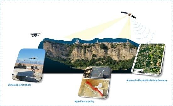
1. Introduction
How can we identify potential slope instabilities in cultural heritage sites that are characterized by inaccessible areas and/or are not completely visible from the observation point?
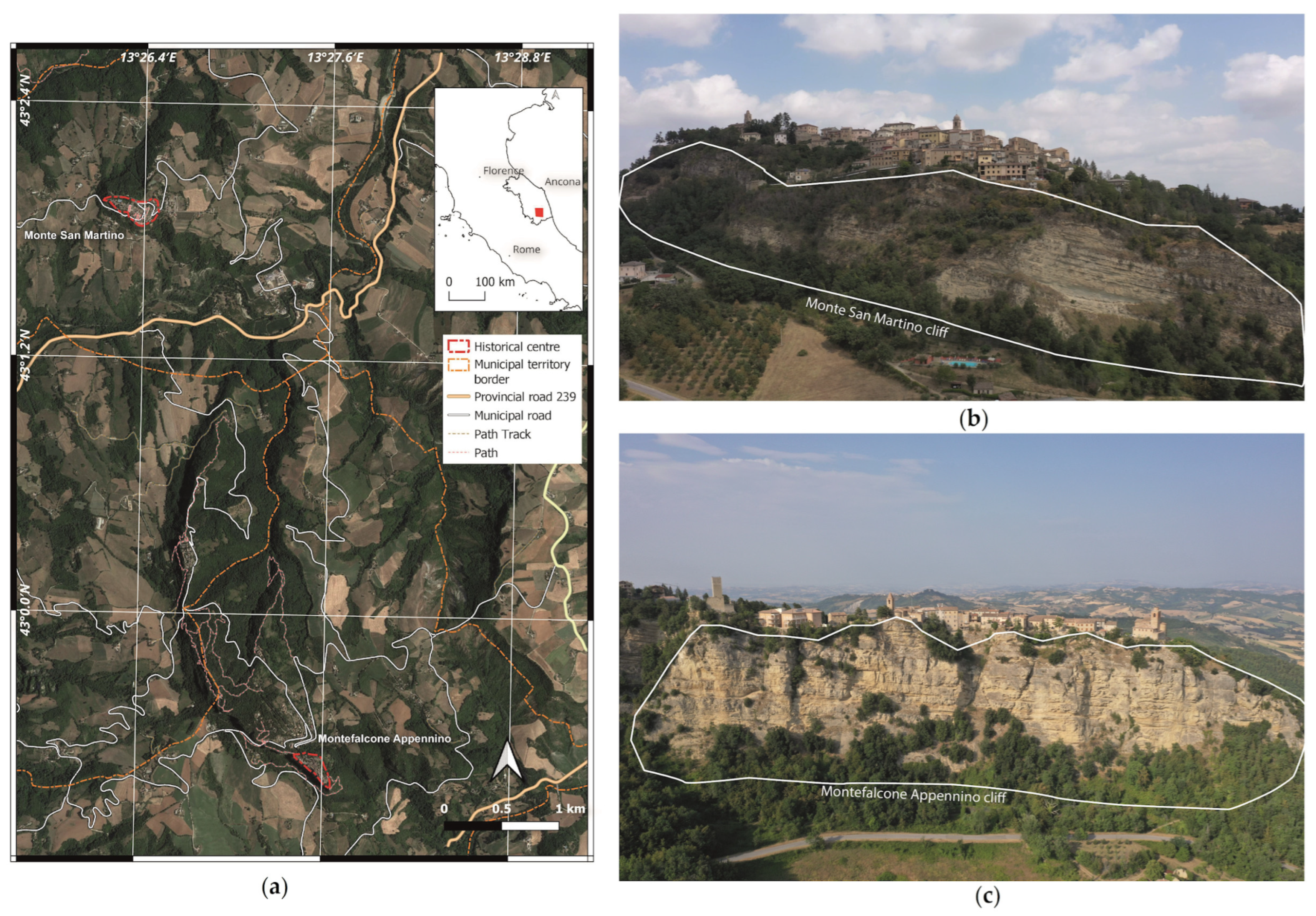
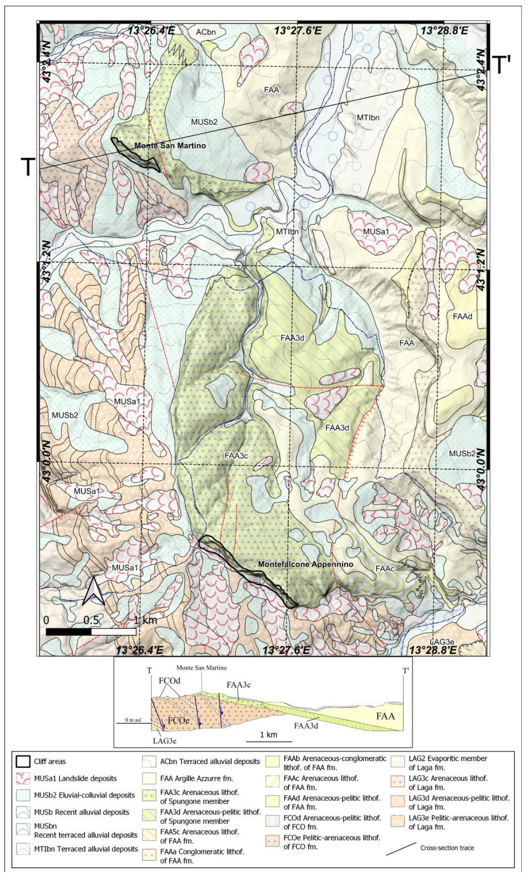
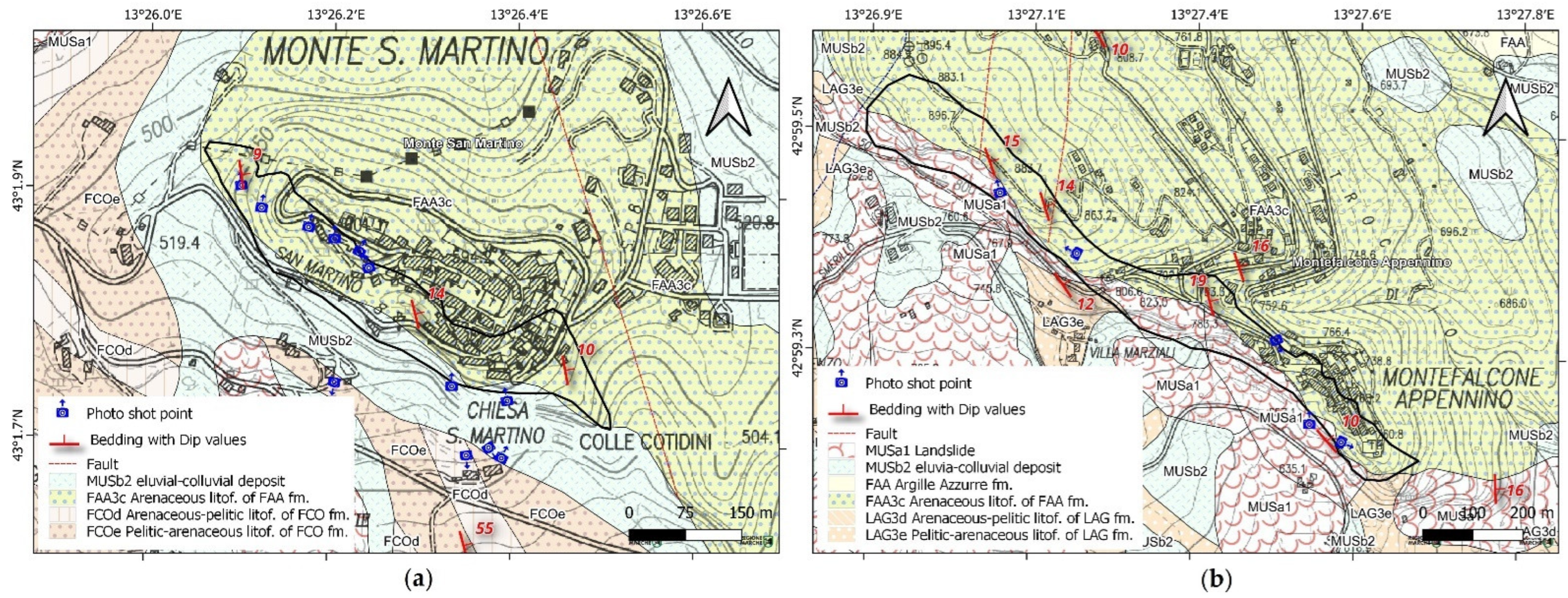
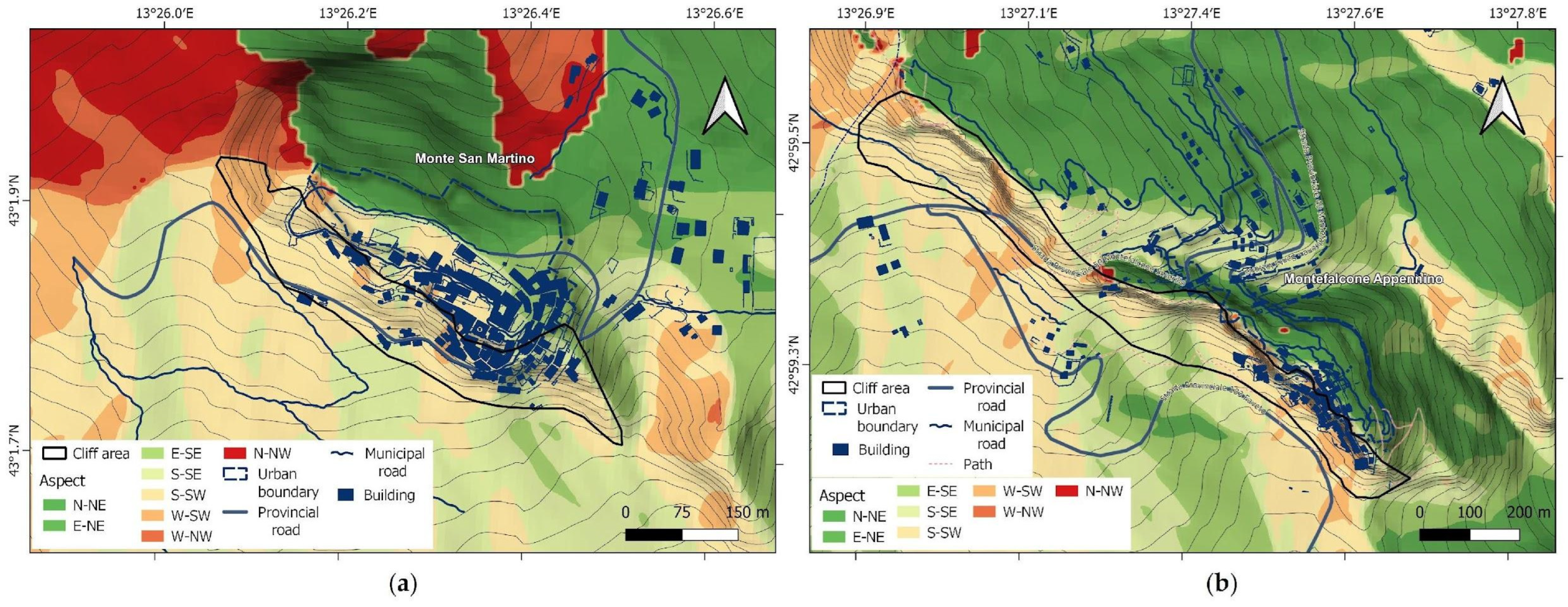
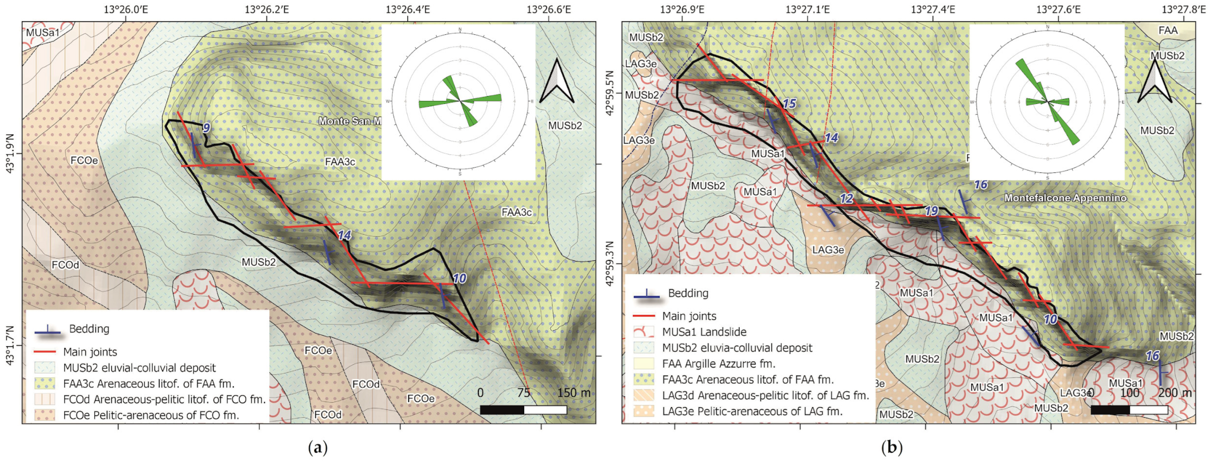
2. Geological Setting
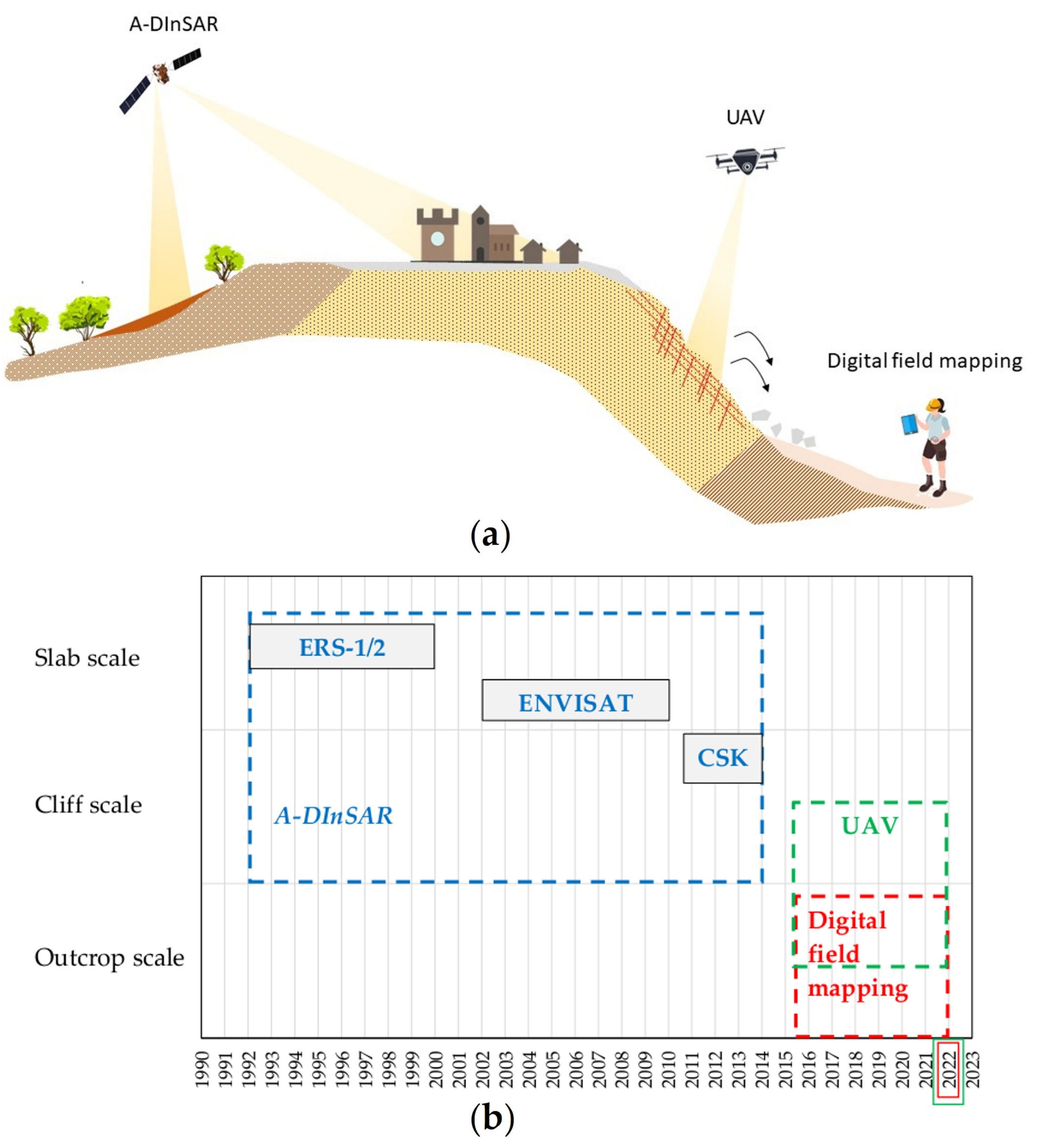
3. Methods
3.1. Digital Field Survey
3.2. DEM Analysis
3.3. UAV
3.4. A-DInSAR
4. Results
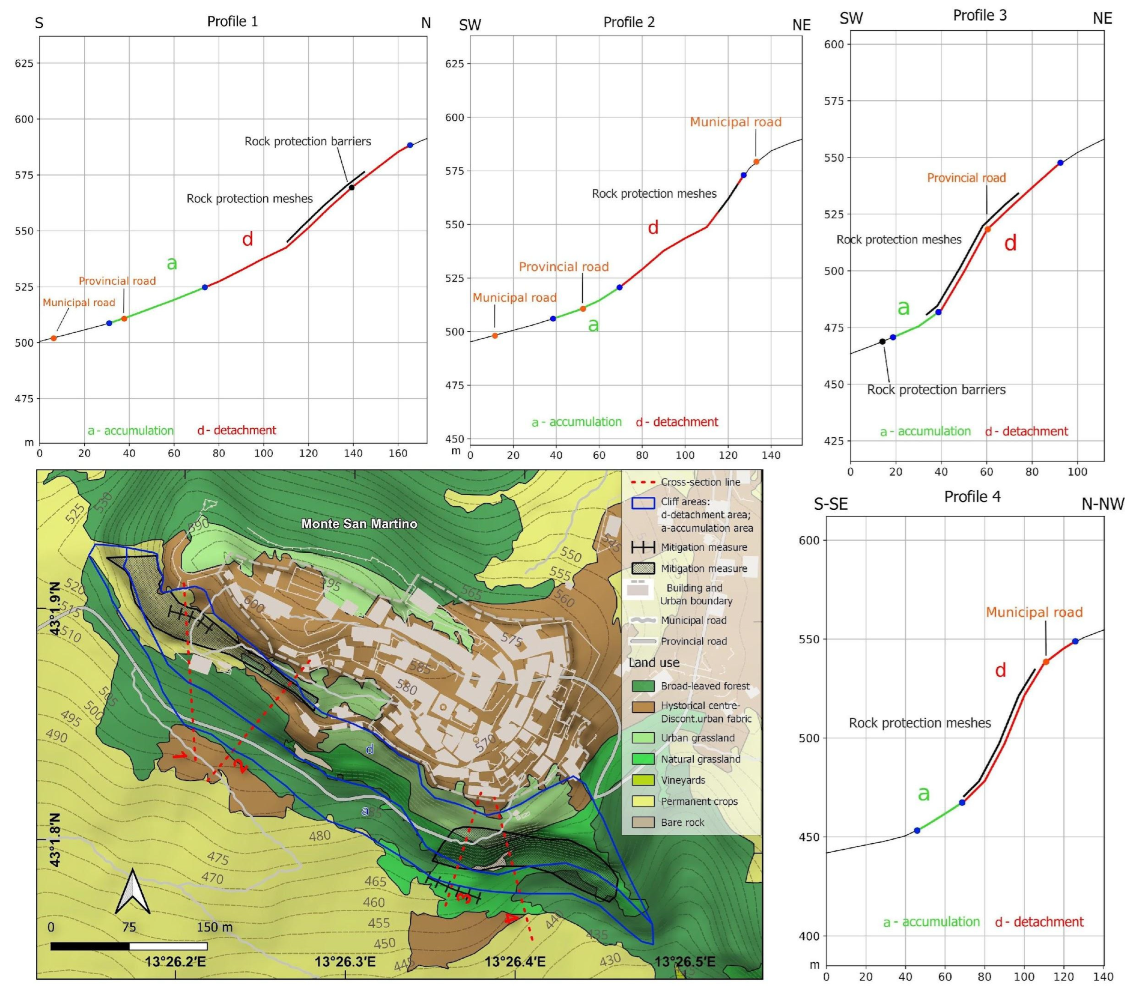
4.1. Digital Field Mapping
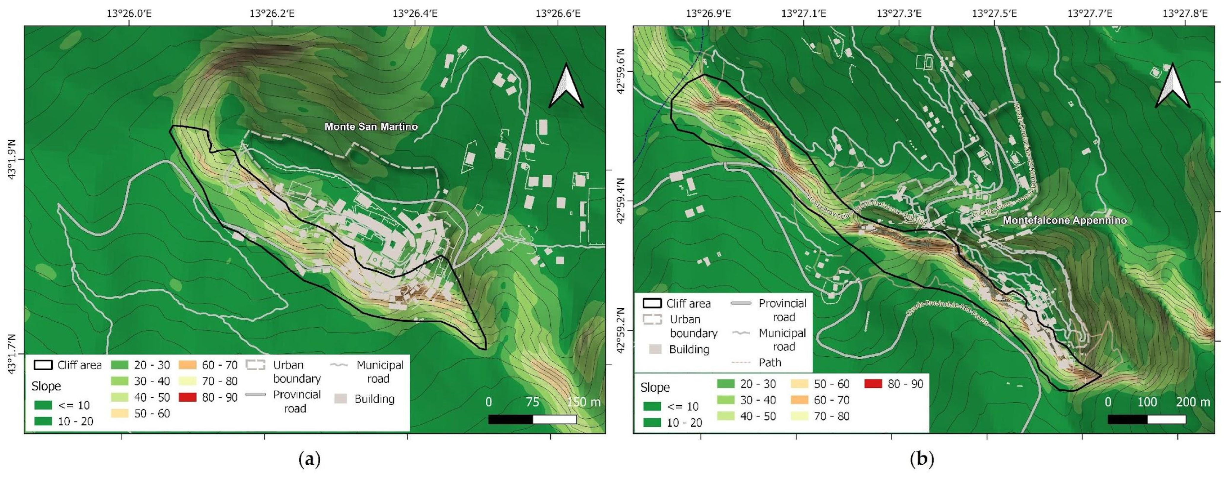
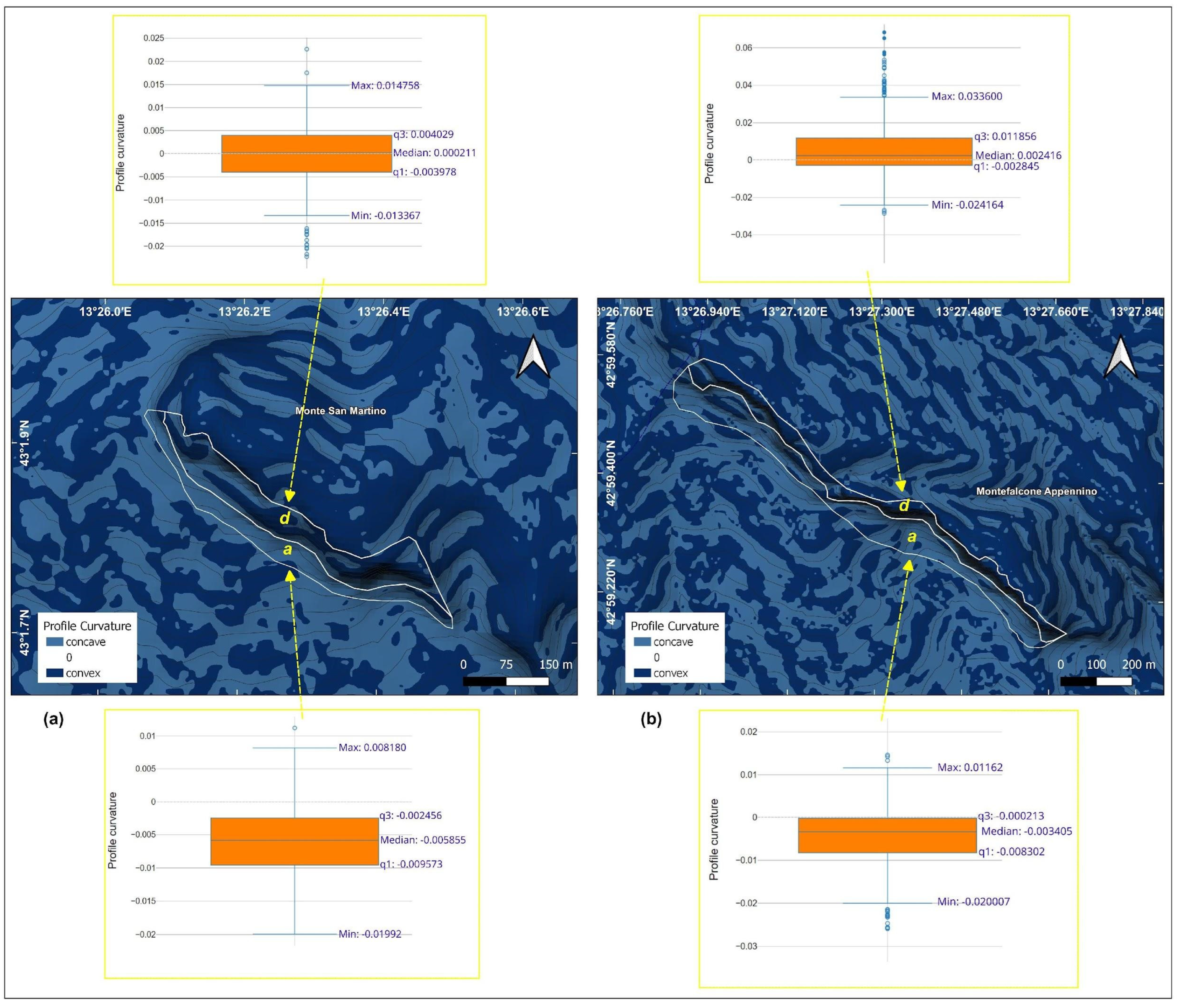
4.2. DEM-Based Geomorphologic Features
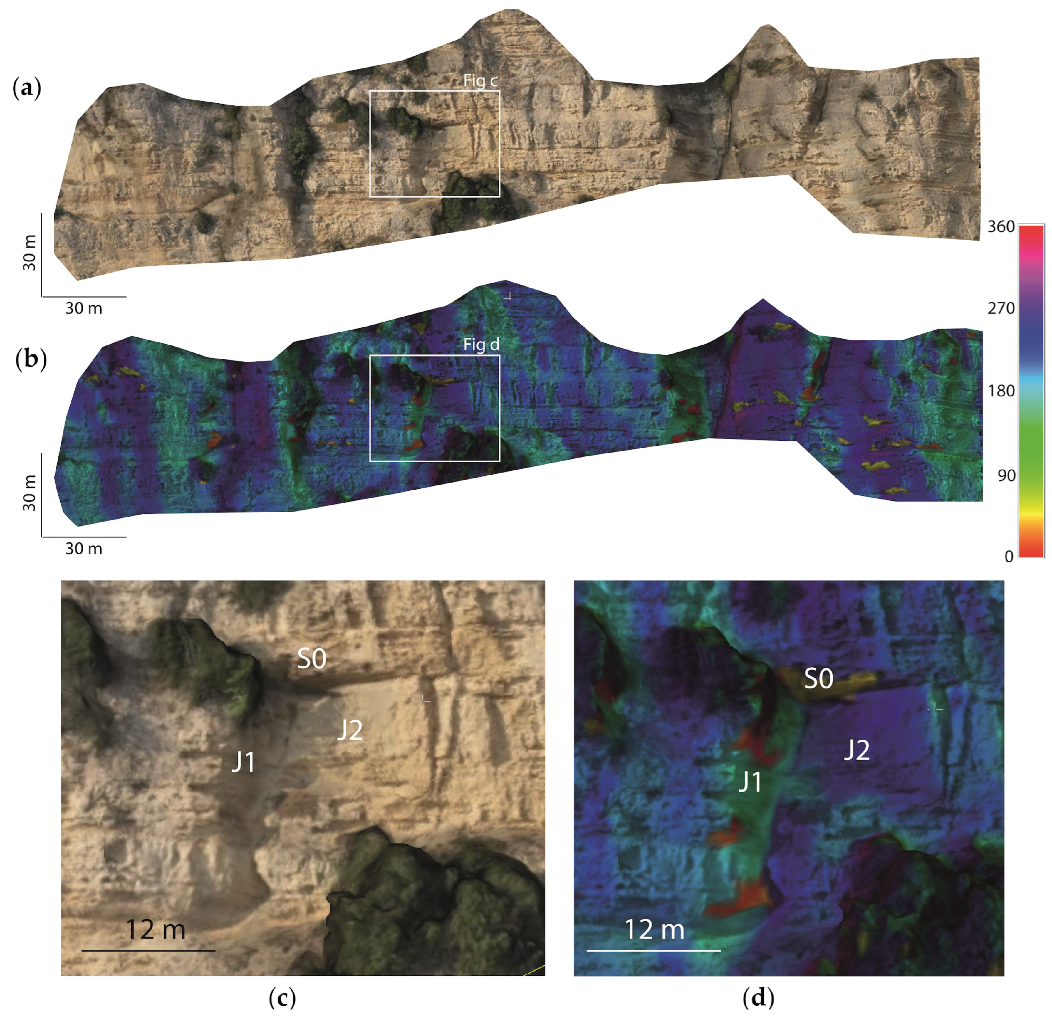
4.3. UAV Models and Structural Setting
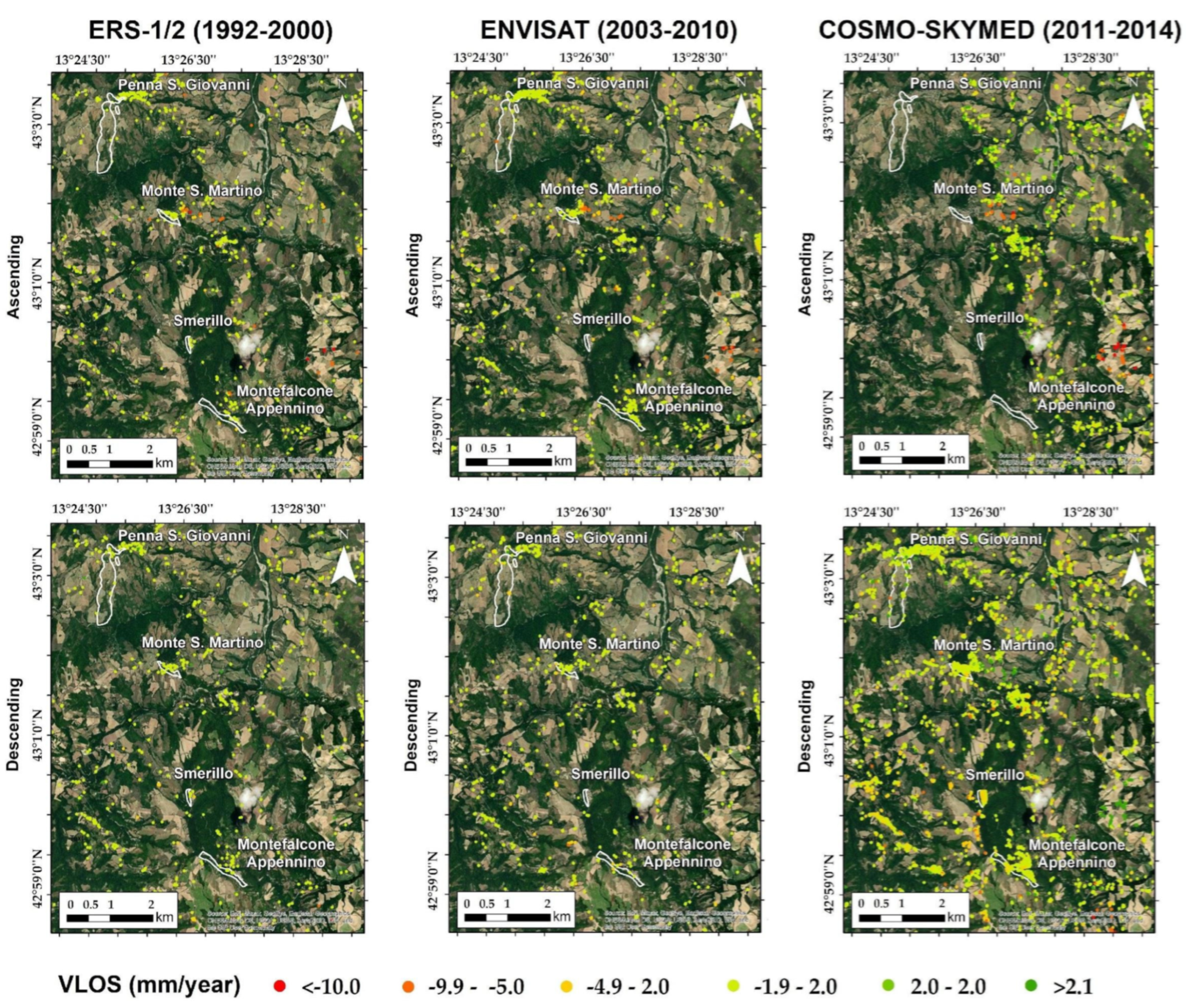
4.4. A-DInSAR-Based Velocity and Displacement Time Series
5. Discussion
6. Conclusions
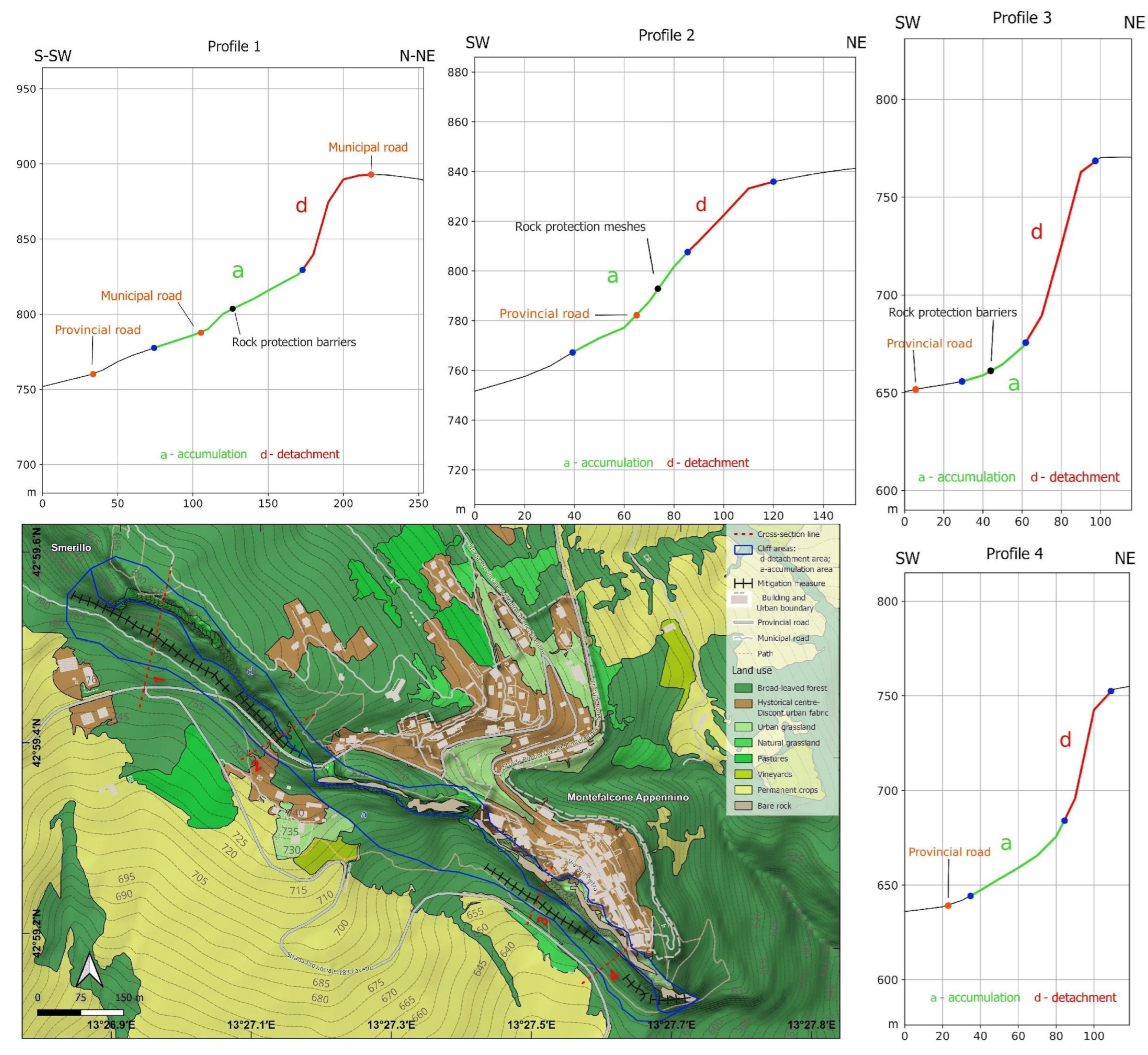
- Digital geological surveys permit the development of geodatabases directly in the field, including all the information about the geology and mitigation measures installed.
- GIS outputs showcase useful morphometric and morphodynamic information to deepen the knowledge of the studied hills and to support the study with other survey techniques. Furthermore, the use of the profile curvature and the slope’s profile was important to understand the role of urbanization in the historical town built on top of the cliff face. In fact, urbanization decreases water infiltration in the slopes and, at the same time, the slope’s evolution.
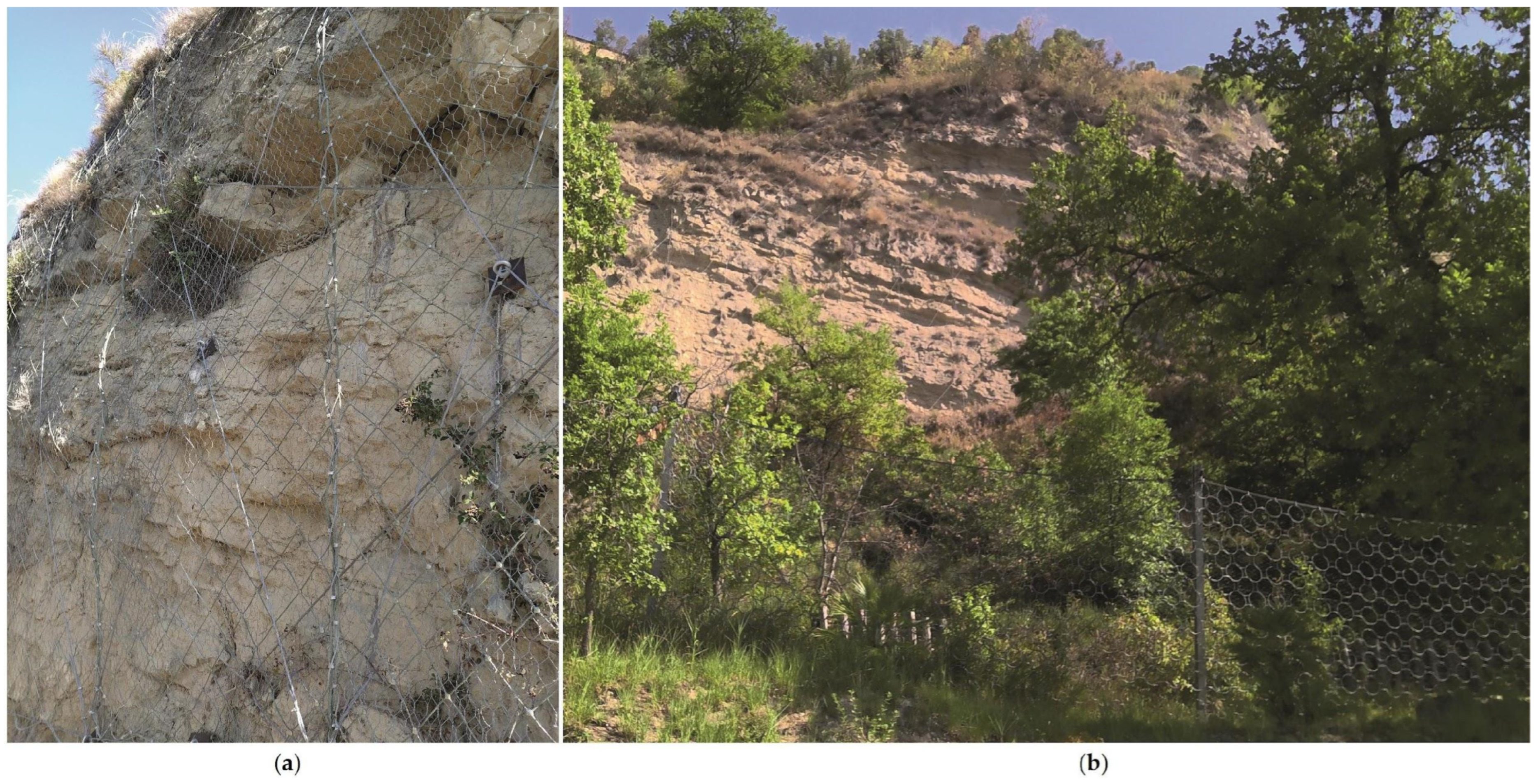
- The use of UAV is fundamental for defining the main discontinuity sets affecting the steep cliff and the volume of potentially failing blocks. This, in combination with the information about the installed mitigation measures, permits us to remarkably improve rockfall mitigation strategies.
- A-DInSAR playes a key role in the identification of potential slow-moving landslides, which impossible to be detected with UAV and digital surveys.
Author Contributions
Funding
Data Availability Statement
Conflicts of Interest
References
- Morelli, S.; Pazzi, V.; Tanteri, L.; Nocentini, M.; Lombardi, L.; Gigli, G.; Tofani, V.; Casagli, N. Characterization and Geotechnical Investigations of a Riverbank Failure in Florence, Italy, UNESCO World Heritage Site. J. Geotech. Geoenviron. Eng. 2020, 146, 05020009. [Google Scholar] [CrossRef]
- Gallerini, G.; De Donatis, M.; Baioni, D.; Bruciatelli, L. Landslide Field Mapping with Tablet Pc. A New Integrated Approach. In Proceedings of the 11th International Conference and Field Trip on Landslides, Norway, Landslides, Norway, 1–10 September 2005; Taylor & Francis: London, UK; Vol. Landslides and Avalanches, Proceedings, pp. 107–113. [Google Scholar]
- Baioni, D.; De Donatis, M.D.D.M.; Giuliano, G. Bruciatelli Lorenzo Il Mobile-Gis per La Geologia Ambientale: Il Rilevamento Digitale Applicato Alle Frane. Geol. Dell’ambiente 2007, 15, 21–26. [Google Scholar]
- Gallerini, G.; De Donatis, M. Rilevamento Digitale Delle Frane: Applicazione Della Scheda IFFI. Rend. Della Soc. Geol. Ital. 2007, 4, 49–53. [Google Scholar]
- Evans, H.; Pennington, C.; Jordan, C.; Foster, C. Mapping a Nation’s Landslides: A Novel Multi-Stage Methodology. In Landslide Science and Practice: Volume 1: Landslide Inventory and Susceptibility and Hazard Zoning; Margottini, C., Canuti, P., Sassa, K., Eds.; Springer: Berlin/Heidelberg, Germany, 2013; pp. 21–27. ISBN 978-3-642-31325-7. [Google Scholar]
- De Donatis, M.; Pappafico, G.F.; Romeo, R.W. A Field Data Acquisition Method and Tools for Hazard Evaluation of Earthquake-Induced Landslides with Open Source Mobile GIS. ISPRS Int. J. Geo-Inf. 2019, 8, 91. [Google Scholar] [CrossRef]
- Casagli, N.; Frodella, W.; Morelli, S.; Tofani, V.; Ciampalini, A.; Intrieri, E.; Raspini, F.; Rossi, G.; Tanteri, L.; Lu, P. Spaceborne, UAV and Ground-Based Remote Sensing Techniques for Landslide Mapping, Monitoring and Early Warning. Geoenvironmen. Disasters 2017, 4, 9. [Google Scholar] [CrossRef]
- Tapete, D.; Cigna, F. COSMO-SkyMed SAR for Detection and Monitoring of Archaeological and Cultural Heritage Sites. Remote Sens. 2019, 11, 1326. [Google Scholar] [CrossRef]
- Mateos, R.M.; Ezquerro, P.; Azañón, J.M.; Gelabert, B.; Herrera, G.; Fernández-Merodo, J.A.; Spizzichino, D.; Sarro, R.; García-Moreno, I.; Béjar-Pizarro, M. Coastal Lateral Spreading in the World Heritage Site of the Tramuntana Range (Majorca, Spain). The Use of PSInSAR Monitoring to Identify Vulnerability. Landslides 2018, 15, 797–809. [Google Scholar] [CrossRef]
- Ferretti, A.; Prati, C.; Rocca, F. Permanent Scatterers in SAR Interferometry. IEEE Trans. Geosci. Remote Sens. 2001, 39, 8–20. [Google Scholar] [CrossRef]
- Sarro, R.; Riquelme, A.; García-Davalillo, J.C.; Mateos, R.M.; Tomás, R.; Pastor, J.L.; Cano, M.; Herrera, G. Rockfall Simulation Based on UAV Photogrammetry Data Obtained during an Emergency Declaration: Application at a Cultural Heritage Site. Remote Sens. 2018, 10, 1923. [Google Scholar] [CrossRef]
- Francioni, M.; Antonaci, F.; Sciarra, N.; Robiati, C.; Coggan, J.; Stead, D.; Calamita, F. Application of Unmanned Aerial Vehicle Data and Discrete Fracture Network Models for Improved Rockfall Simulations. Remote Sens. 2020, 12, 2053. [Google Scholar] [CrossRef]
- Graber, A.; Santi, P. UAV-Photogrammetry Rockfall Monitoring of Natural Slopes in Glenwood Canyon, CO, USA: Background Activity and Post-Wildfire Impacts. Landslides 2023, 20, 229–248. [Google Scholar] [CrossRef]
- Mammoliti, E.; Pepi, A.; Fronzi, D.; Morelli, S.; Volatili, T.; Tazioli, A.; Francioni, M. 3D Discrete Fracture Network Modelling from UAV Imagery Coupled with Tracer Tests to Assess Fracture Conductivity in an Unstable Rock Slope: Implications for Rockfall Phenomena. Remote Sens. 2023, 15, 1222. [Google Scholar] [CrossRef]
- Micarelli, A.; Cantalamessa, G.; Didaskalou, P.; Potetti, M.; Pambianchi, G.; Le Pera, E.; Critelli, S.; Pennesi, T.; Mazzoli, S. Note Illustrative Della Carta Geologica D’italia Alla Scala 1:50.000. Foglio 314 Montegiorgio; Note illustrative della Carta Geologica d’Italia in scala 1:50.000; APAT-Servizio Geologico d’Italia: Rome, Italy, 2006. [Google Scholar]
- Micarelli, A.; Cantalamessa, G.; Di Celma, C.; Piccini, M.; Sabatinelli, M.; Mazzoli, S. Geological Sheet 314 “Montegiorgio” of the Geologic Map of Italy at the Scale of 1:50.000. 2006. Available online: https://www.isprambiente.gov.it/Media/carg/314_MONTEGIORGIO/Foglio.html (accessed on 27 November 2023).
- QGIS software (version 3.22) by Development Team QGIS Geographic Information System QGIS. Available online: https://www.qgis.org/it/site/ (accessed on 28 September 2022).
- Alberti, M. BeePen, Python Plugin for QGIS Software 2019. Available online: https://github.com/mauroalberti/beePen (accessed on 14 August 2022).
- De Donatis, M.; Alberti, M.; Cesarini, C.; Menichetti, M.; Susini, S. Open Source GIS for Geological Field Mapping: Research and Teaching Experience. PeerJ 2016, 4, e2258v3. [Google Scholar] [CrossRef]
- OPENGIS.Ch. Available online: https://www.opengis.ch/ (accessed on 7 October 2022).
- Mergin Maps: Raccogliere, Archiviare e Analizzare Facilmente i Dati Geografici. Available online: https://it.merginmaps.com/ (accessed on 7 September 2023).
- Campbell, E.; Duncan, I.; Hibbitts, H. Analysis of Errors Occurring in the Transfer of Geologic Point Data from Field Maps to Digital Data Sets. In Proceedings of the Workshop Proceedings, Baton Rouge, LA, USA, 24–27 April 2005; USGS: Baton Rouge, LA, USA; Vol. U.S. Geological Survey Open-File Report 2005-1428, pp. 61–65. [Google Scholar]
- De Donatis, M.; Pappafico, G.F.; Bonì, R.; Francioni, M.; Marino, L.; Morelli, S.; Zatserkovny, V.I. Landslide Field Mapping: IFFI-Restart Forms for Data Acquisition and Management for the Classification of Landslides in the Municipalities Affected by the 2016 Central Italy Earthquake. Preprints 2022, 2022110461. [Google Scholar] [CrossRef]
- Microsoft Corporation Windows Journal Software for Windows, 7. 2021. Available online: https://www.microsoft.com/en-us/download/details.aspx?id=53003 (accessed on 27 November 2023).
- GeoPackage Encoding Standard. Open Geospatial Consortium. Available online: https://www.geopackage.org/ (accessed on 27 November 2023).
- Tarquini, S.; Isola, I.; Favalli, M.; Mazzarini, F.; Bisson, M.; Pareschi, M.T.; Boschi, E. TINITALY/01: A New Triangular Irregular Network of Italy. Annals of Geophysics. 2007. Available online: http://hdl.handle.net/2122/3673 (accessed on 27 November 2023).
- Tarquini, S.; Isola, I.; Favalli, M.; Battistini, A.; Dotta, G. TINITALY, a Digital Elevation Model of Italy with a 10 Meters Cell Size (Version 1.1). Istituto Nazionale di Geofisica e Vulcanologia (INGV) 2023. [Google Scholar] [CrossRef]
- Li, Z.; Zhu, Q.; Gold, C. Digital Terrain Modeling: Principles and Methodology; CRC Press: New York, NY, USA, 2005; ISBN 978-0-415-32462-5. [Google Scholar]
- Morelli, S.; Pazzi, V.; Frodella, W.; Fanti, R. Kinematic Reconstruction of a Deep-Seated Gravitational Slope Deformation by Geomorphic Analyses. Geosciences 2018, 8, 26. [Google Scholar] [CrossRef]
- Radło-Kulisiewicz, M. Review of DTM Derivatives Most Used in Digital Soil Mapping. Geomat. Landmanag. Landsc. 2021, 87–99. [Google Scholar] [CrossRef]
- Conrad, O.; Bechtel, B.; Bock, M.; Dietrich, H.; Fischer, E.; Gerlitz, L.; Wehberg, J.; Wichmann, V.; Böhner, J. System for Automated Geoscientific Analyses (SAGA) v. 2.1.4. Geosci. Model Dev. 2015, 8, 1991–2007. [Google Scholar] [CrossRef]
- Blaga, L. Aspects Regarding the Significance of the Curvature Types and Values in the Studies of Geomorphometry Assisted by GIS. Anal. Univ. Oradea Ser. Geogr. 2012, 2012, 327–337. [Google Scholar]
- Minár, J.; Jenčo, M.; Evans, I.S.; Minár, J., Jr.; Kadlec, M.; Krcho, J.; Pacina, J.; Burian, L.; Benová, A. Third-Order Geomorphometric Variables (Derivatives): Definition, Computation and Utilization of Changes of Curvatures. Int. J. Geogr. Inf. Sci. 2013, 27, 1381–1402. [Google Scholar] [CrossRef]
- Florinsky, I.V. An Illustrated Introduction to General Geomorphometry. Prog. Phys. Geogr. Earth Environ. 2017, 41, 723–752. [Google Scholar] [CrossRef]
- Agisoft Metashape, version 1. 6.4; Agisoft LLC: St. Petersburg, Russia, 2020. [Google Scholar]
- CloudCompare-Open Source Project 2022, version 2.12.4. Available online: https://www.danielgm.net/cc/ (accessed on 6 September 2023).
- Di Martire, D.; Paci, M.; Confuorto, P.; Costabile, S.; Guastaferro, F.; Verta, A.; Calcaterra, D. A Nation-Wide System for Landslide Mapping and Risk Management in Italy: The Second Not-Ordinary Plan of Environmental Remote Sensing. Int. J. Appl. Earth Obs. Geoinf. 2017, 63, 143–157. [Google Scholar] [CrossRef]
- Costantini, M.; Falco, S.; Malvarosa, F.; Minati, F. A New Method for Identification and Analysis of Persistent Scatterers in Series of Sar Images. In Proceedings of the IGARSS 2008—2008 IEEE International Geoscience and Remote Sensing Symposium, Boston, MA, USA, 7-11 July 2008; Volume 2, pp. 449–452. [Google Scholar]
- Tapete, D.; Cigna, F. Satellite-Based Preventive Diagnosis: Use of Persistent Scatterer Interferometry on Cultural Heritage Sites in Italy. In Proceedings of the Remote Sensing and Photogrammetry Society Conference 2012, London, UK, 12–14 September 2012; University of Greenwich: London, UK; pp. 1–4. [Google Scholar]
- CARG Project-Geologic and Geothematic Cartography. Available online: https://www.isprambiente.gov.it/en/projects/soil-and-territory/carg-project-geologic-and-geothematic-cartography-1 (accessed on 12 October 2022).
- Bartolini, C.; Peccerillo, A. I Fattori Geologici Delle Forme del Rilievo; Il Sistema Terra; Pitagora Editrice: Bologna, Italy, 2002; ISBN 88-371-1203-3. [Google Scholar]
- Penck, W. Die Morphologische Analyse: Ein Kapitel Der Physikalischen Geologie; J. Engelhorns Nachf.: Stuttgart, Germany, 1924. [Google Scholar]
- Lehmann, O. Morphologische Theorie Der Verwitterung von Steinschlagwänden. In Vierteljahrsschrift 78/3-4—Naturforschende Gesellschaft in Zürich (NGZH); NGZH: Zürich, Switzerland, 1933; Volume 78/3-4, pp. 83–126. [Google Scholar]
- Tommasi, P.; Sciotti, M.; Rotonda, T.; Boldini, L.V.D. The Role of Geotechnical Conditions in the Foundation, Expansion and Preservation of the Ancient Town of Orvieto (Italy). In Geotechnics and Heritage: Case Histories, 1st ed.; Bilotta, E., Flora, A., Lirer, S., Viggiani, C., Eds.; CRC Press: Boca Raton, FL, USA, 2013; ISBN 978-0-429-22794-3. [Google Scholar] [CrossRef]
- Raska, P.; Klimes, J.; Dubisar, J. Using Local Archive Sources to Reconstruct Historical Landslide Occurrence in Selected Urban REgions of the Czech Republic: Examples from Regions with Different Historical Development. Land Degrad. Dev. 2015, 26, 142–157. [Google Scholar] [CrossRef]
- Bonì, R.; Pilla, G.; Meisina, C. Methodology for Detection and Interpretation of Ground Motion Areas with the A-DInSAR Time Series Analysis. Remote Sens. 2016, 8, 686. [Google Scholar] [CrossRef]
- Fernandez-Merodo, J.A.; Mateos, R.M.; Azañon, J.M.; Ezquerro, P.; García-Davalillo, J.C.; Bejar, M.; Herrera, G.; Novo, C.; Bee, E.; Themistocleous, K.; et al. Multiscale Analysis of Geo-Hazards Affecting the Alhambra Cultural Heritage. In Sustainable Conservation of UNESCO and Other Heritage Sites through Proactive Geosciences; El-Qady, G.M., Margottini, C., Eds.; Springer Geology; Springer International Publishing: Cham, Switzerland, 2023; pp. 47–61. ISBN 978-3-031-13810-2. [Google Scholar]
- Aringoli, D.; Materazzi, M.; Gentili, B.; Pambianchi, G.; Sciarra, N. Slope Stability Integrate Analyses: The Study Case of Mount Falcone (Central Italy). In Proceedings of the Engineering Geology for Society and Territory; Lollino, G., Giordan, D., Crosta, G.B., Corominas, J., Azzam, R., Wasowski, J., Sciarra, N., Eds.; Springer International Publishing: Cham, Switzerland, 2015; Volume 2, pp. 1371–1376. [Google Scholar]
- Crescenti, U.; Sciarra, N.; Gentili, B.; Pambianchi, G. Modeling of Complex Deep-Seated Mass Movements in the Central-Southern Marches (Central Italy). In Landslides; Routledge: Abingdon, UK, 2018; pp. 149–155. [Google Scholar]
- Materazzi, M.; Bufalini, M.; Gentilucci, M.; Pambianchi, G.; Aringoli, D.; Farabollini, P. Landslide Hazard Assessment in a Monoclinal Setting (Central Italy): Numerical vs. Geomorphological Approach. Land 2021, 10, 624. [Google Scholar] [CrossRef]
- Spreafico, M.C.; Perotti, L.; Cervi, F.; Bacenetti, M.; Bitelli, G.; Girelli, V.A.; Mandanici, E.; Tini, M.A.; Borgatti, L. Terrestrial Remote Sensing Techniques to Complement Conventional Geomechanical Surveys for the Assessment of Landslide Hazard: The San Leo Case Study (Italy). Eur. J. Remote Sens. 2015, 48, 639–660. [Google Scholar] [CrossRef]
- Casagli, N.; Delmonaco, G.; Focardi, P.; Margottini, C.; Serafini, S. Analisi Dei Fenomeni Di Dissesto a Civita Di Bagnoregio Ed Interventi Di Stabilizzazione. In Proceedings of the International Conference Geological and Geotechnical Influences in the Preservation of Historical and Cultural Heritage, Torino, Italy, 7–9 June 2000; CNR-IRPI: Turin, Italy; pp. 351–363. [Google Scholar]
- De Donatis, M.; Alberti, M.; Cipicchia, M.; Guerrero, N.M.; Pappafico, G.F.; Susini, S. Workflow of Digital Field Mapping and Drone-Aided Survey for the Identification and Characterization of Capable Faults: The Case of a Normal Fault System in the Monte Nerone Area (Northern Apennines, Italy). ISPRS Int. J. Geo-Inf. 2020, 9, 616. [Google Scholar] [CrossRef]
- Yakar, M.; Ulvi, A.; Yiğit, A.Y.; Alptekin, A. Discontinuity Set Extraction from 3D Point Clouds Obtained by UAV Photogrammetry in a Rockfall Site. Surv. Rev. 2023, 55, 416–428. [Google Scholar] [CrossRef]
- Karataş, L.; Alptekin, A.; Yakar, M. Detection and Documentation of Stone Material Deterioration in Historical Masonry Structures Using UAV Photogrammetry: A Case Study of Mersin Aba Mausoleum. Adv. UAV 2022, 2, 51–64. [Google Scholar]
- Şasi, A.; Yakar, M. Photogrammetric Modelling of Sakahane Masjid Using an Unmanned Aerial Vehicle. TUJE 2017, 1, 82–87. [Google Scholar] [CrossRef]
- Bekaert, D.P.S.; Handwerger, A.L.; Agram, P.; Kirschbaum, D.B. InSAR-Based Detection Method for Mapping and Monitoring Slow-Moving Landslides in Remote Regions with Steep and Mountainous Terrain: An Application to Nepal. Remote Sens. Environ. 2020, 249, 111983. [Google Scholar] [CrossRef]
- Béjar-Pizarro, M.; Notti, D.; Mateos, R.M.; Ezquerro, P.; Centolanza, G.; Herrera, G.; Bru, G.; Sanabria, M.; Solari, L.; Duro, J.; et al. Mapping Vulnerable Urban Areas Affected by Slow-Moving Landslides Using Sentinel-1 InSAR Data. Remote Sens. 2017, 9, 876. [Google Scholar] [CrossRef]
- Urgilez Vinueza, A.; Handwerger, A.L.; Bakker, M.; Bogaard, T. A New Method to Detect Changes in Displacement Rates of Slow-Moving Landslides Using InSAR Time Series. Landslides 2022, 19, 2233–2247. [Google Scholar] [CrossRef]
- Cruden, D.M.; Varnes, D.J. Landslide Types and Processes, Special Report 1996; Transportation Research Board; National Academy of Sciences: Irvine, CA, USA, 1996; pp. 36–75. [Google Scholar]
- Hanssen, R.F. Satellite Radar Interferometry for Deformation Monitoring: A Priori Assessment of Feasibility and Accuracy. Int. J. Appl. Earth Obs. Geoinf. 2005, 6, 253–260. [Google Scholar] [CrossRef]
- Frodella, W.; Ciampalini, A.; Gigli, G.; Lombardi, L.; Raspini, F.; Nocentini, M.; Scardigli, C.; Casagli, N. Synergic Use of Satellite and Ground-Based Remote Sensing Methods for Monitoring the San Leo Rock Cliff (Northern Italy). Geomorphology 2016, 264, 80–94. [Google Scholar] [CrossRef]
- Romeo, S.; Cosentino, A.; Giani, F.; Mastrantoni, G.; Mazzanti, P. Combining Ground-Based Remote Sensing Tools for Rockfalls Assessment and Monitoring: The Poggio Baldi Landslide Natural Laboratory. Sensors 2021, 21, 2632. [Google Scholar] [CrossRef]
- Zhan, J.; Yu, Z.; Lv, Y.; Peng, J.; Song, S.; Yao, Z. Rockfall Hazard Assessment in the Taihang Grand Canyon Scenic Area Integrating Regional-Scale Identification of Potential Rockfall Sources. Remote Sens. 2022, 14, 3021. [Google Scholar] [CrossRef]


| Case Study | Photos | Overlap | Side Lap | Flight Mode | Distance |
|---|---|---|---|---|---|
| Monte San Martino | 190 | ~80 | ~80 | Manual | ~50 |
| Montefalcone Appennino | 105 | ~80 | ~80 | Manual | ~70 |
| Satellite | Orbit | Revisit Time (Days) | Incidence Angle (°) | No. of SAR Images | Time Span | Ground Resolution (m) |
|---|---|---|---|---|---|---|
| ERS1/2 | Ascending | ~35 | ~23.0 | 50 | 1992–2000 | 20 × 5 |
| ERS1/2 | Descending | ~35 | ~23.0 | 55 | 1992–2000 | 20 × 5 |
| ENVISAT | Ascending | ~24 | ~23.0 | 50 | 2003–2010 | 20 × 5 |
| ENVISAT | Descending | ~24 | ~23.0 | 38 | 2003–2010 | 20 × 5 |
| COSMO-SkyMed | Ascending | ~12 | 27 | 35 | 2011–2014 | 3 × 3 |
| COSMO-SkyMed | Descending | ~12 | 29 | 47 | 2011–2014 | 3 × 3 |
| Case study | Slope dip/dip dir | S0 dip/dip dir | J1 dip/dip dir | J2 dip/dip dir | J3 dip/dip dir |
|---|---|---|---|---|---|
| Monte San Martino | 75/220 | 10/80 | 80/160 | 80/260 | 70/75 |
| Montefalcone Appennino | 75/210 | 20/75 | 60/170 | 70/230 | 70/80 |
Disclaimer/Publisher’s Note: The statements, opinions and data contained in all publications are solely those of the individual author(s) and contributor(s) and not of MDPI and/or the editor(s). MDPI and/or the editor(s) disclaim responsibility for any injury to people or property resulting from any ideas, methods, instructions or products referred to in the content. |
© 2023 by the authors. Licensee MDPI, Basel, Switzerland. This article is an open access article distributed under the terms and conditions of the Creative Commons Attribution (CC BY) license (https://creativecommons.org/licenses/by/4.0/).
Share and Cite
Morelli, S.; Bonì, R.; De Donatis, M.; Marino, L.; Pappafico, G.F.; Francioni, M. A Low-Cost and Fast Operational Procedure to Identify Potential Slope Instabilities in Cultural Heritage Sites. Remote Sens. 2023, 15, 5574. https://doi.org/10.3390/rs15235574
Morelli S, Bonì R, De Donatis M, Marino L, Pappafico GF, Francioni M. A Low-Cost and Fast Operational Procedure to Identify Potential Slope Instabilities in Cultural Heritage Sites. Remote Sensing. 2023; 15(23):5574. https://doi.org/10.3390/rs15235574
Chicago/Turabian StyleMorelli, Stefano, Roberta Bonì, Mauro De Donatis, Lucia Marino, Giulio Fabrizio Pappafico, and Mirko Francioni. 2023. "A Low-Cost and Fast Operational Procedure to Identify Potential Slope Instabilities in Cultural Heritage Sites" Remote Sensing 15, no. 23: 5574. https://doi.org/10.3390/rs15235574