

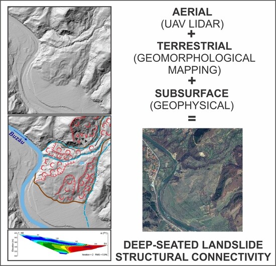
Deciphering Complex Morphology and Structural Connectivity of High-Magnitude Deep-Seated Landslides via Airborne Laser Scanning: A Case Study in the Vrancea Seismic Region, Romanian Carpathians
 , and
, and
Abstract
:
1. Introduction
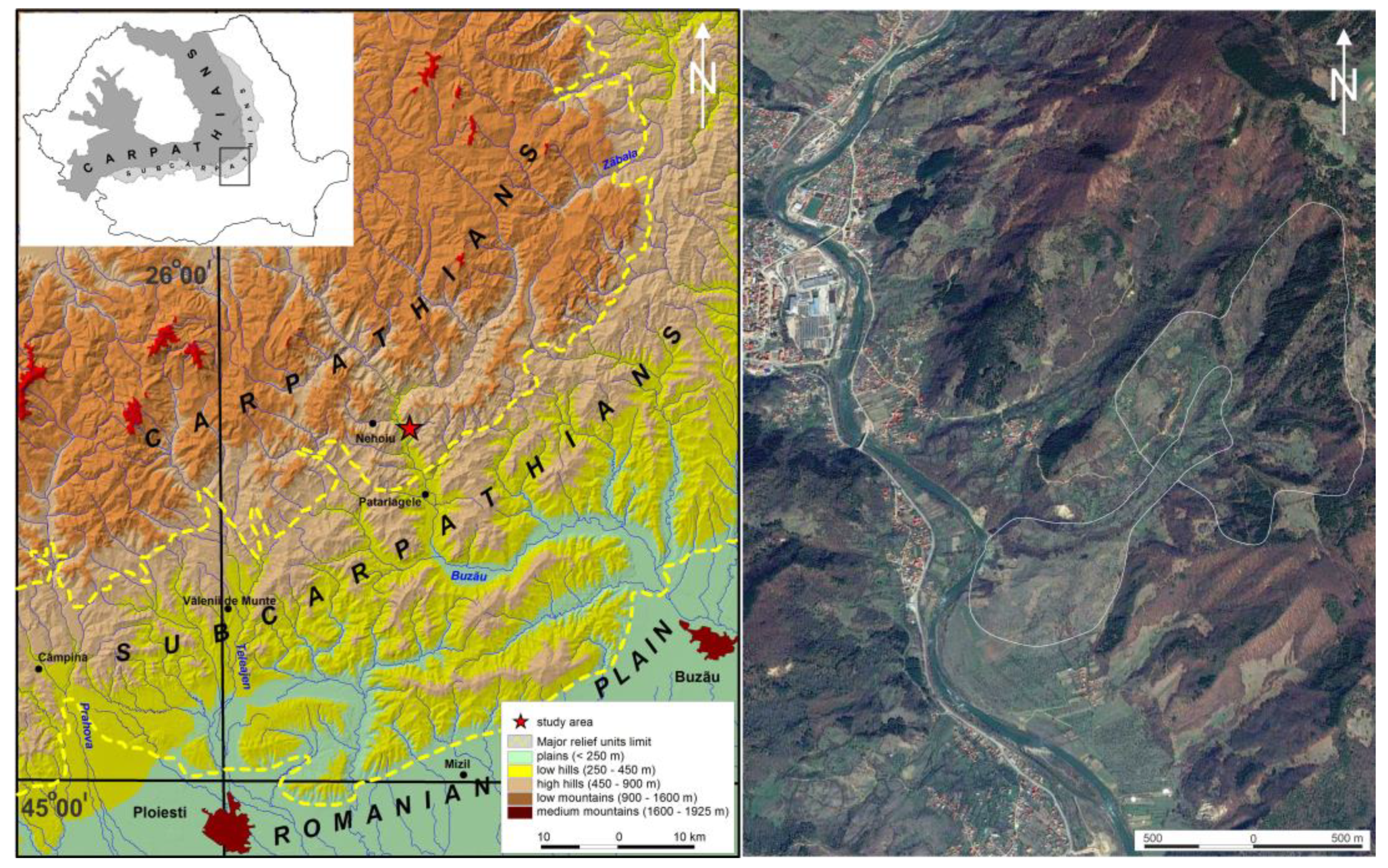
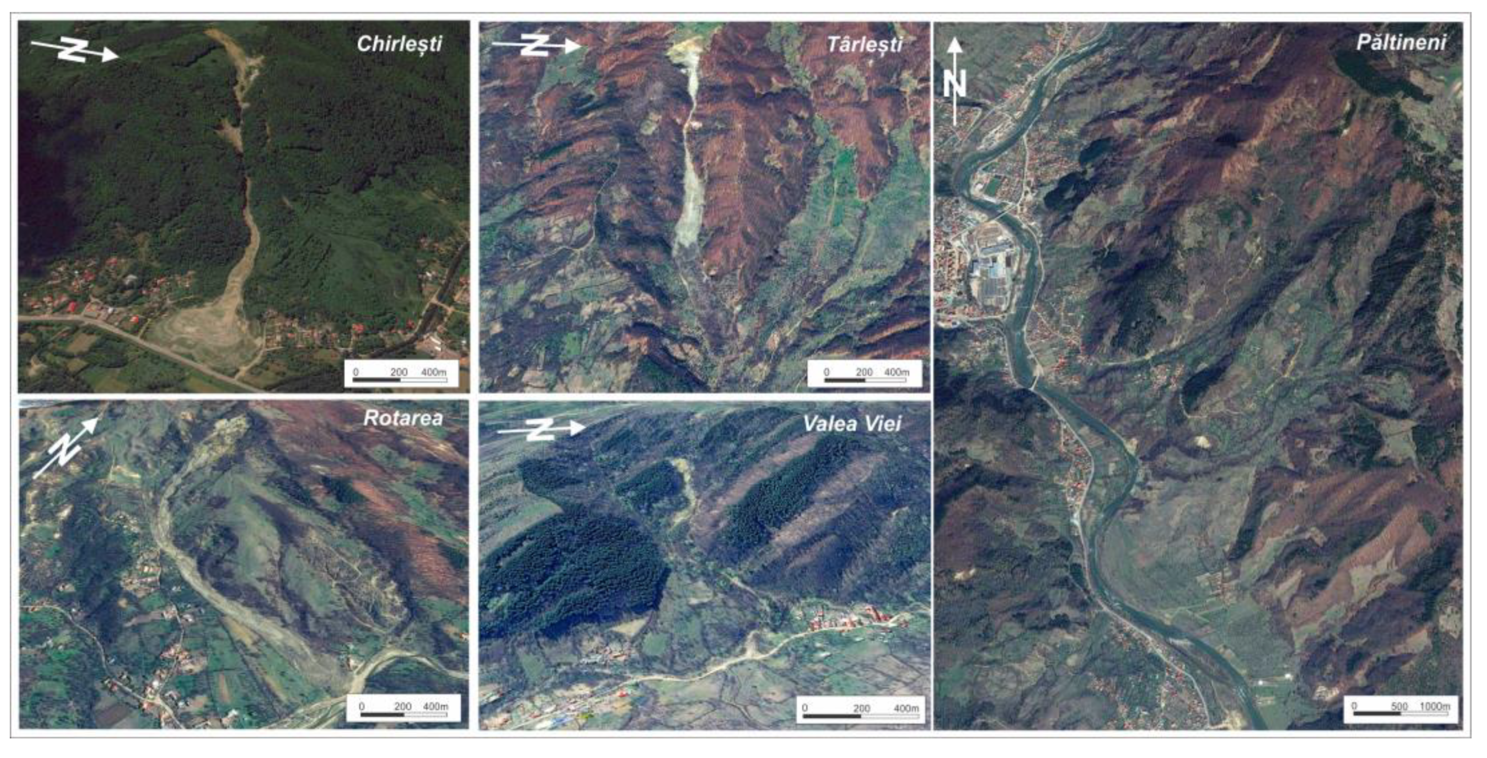
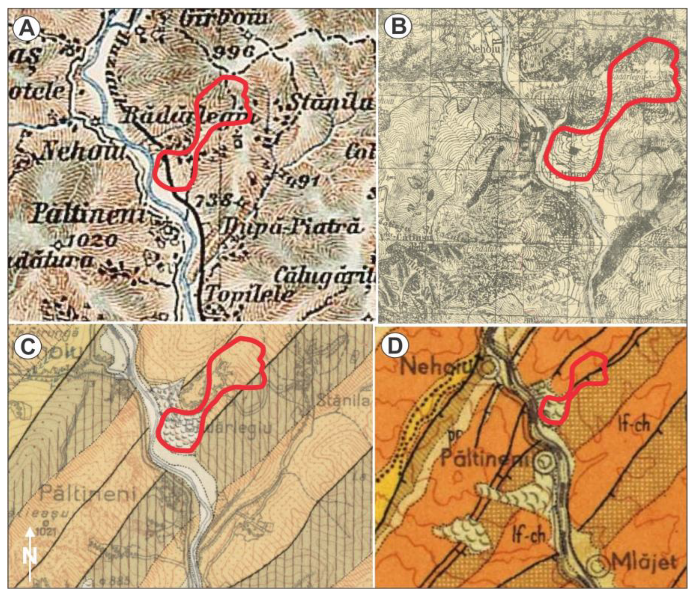
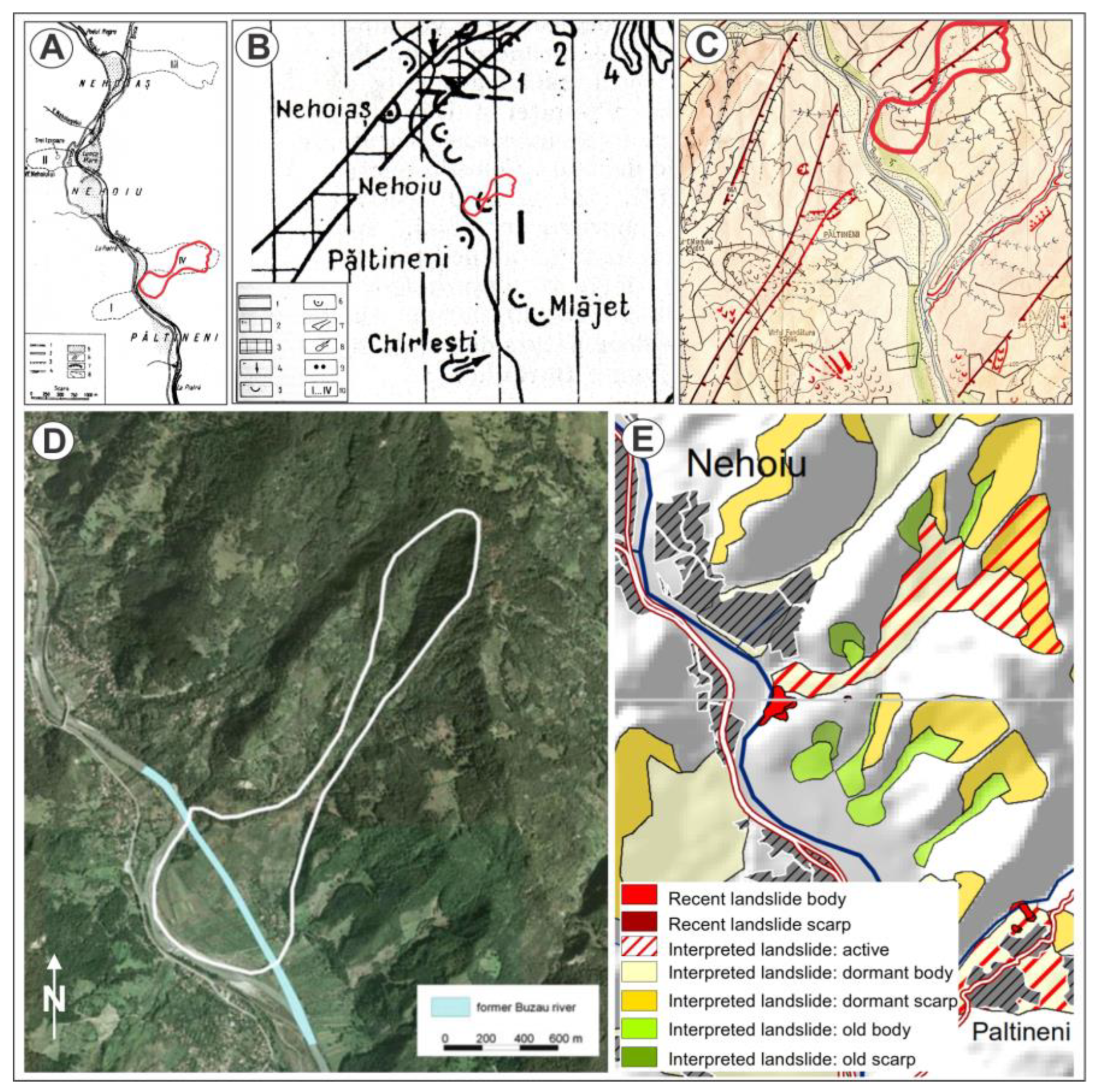
2. Study Area

3. Materials and Methods
- Data Acquisition: The process involved laser emission and reflection, time-of-flight measurement and recording of position and orientation data. To ensure accuracy, GPS and IMU components were integrated to provide precise location information and capture the sensor’s motion and orientation during the survey. The drone followed the terrain at a height of 80–120 m with an average point density of 80 points/m2, all within an accuracy threshold of less than 5 cm.
- Data Pre-processing: Systematic errors or biases in the sensor’s measurements were addressed through calibration. Noise points and outliers were filtered out to enhance data quality. The incorporation of IMU and GPS data, augmented with RTK corrections, facilitated precise georeferencing, thereby elevating the overall data reliability.
- Point Cloud Generation: The point cloud generation process accounted for multiple returns from a single laser pulse, which occurred due to reflections from different surfaces or objects. Each return was recorded separately in the point cloud, providing multiple elevation measurements for each location. This step resulted in different categories, including ground points, vegetation points, buildings and other objects, which was particularly beneficial in vegetated areas.
- Point Cloud Classification: Point cloud classification was carried out to distinguish ground points from aboveground features such as vegetation, buildings and other objects. The classification was performed using the CSF [46] plugin in Cloud Compare (Table 3), which utilized a 3D computer graphics algorithm based on cloth simulation. This allowed the extraction of ground points from the LiDAR point cloud, effectively separating it into ground and aboveground points.
- 5.
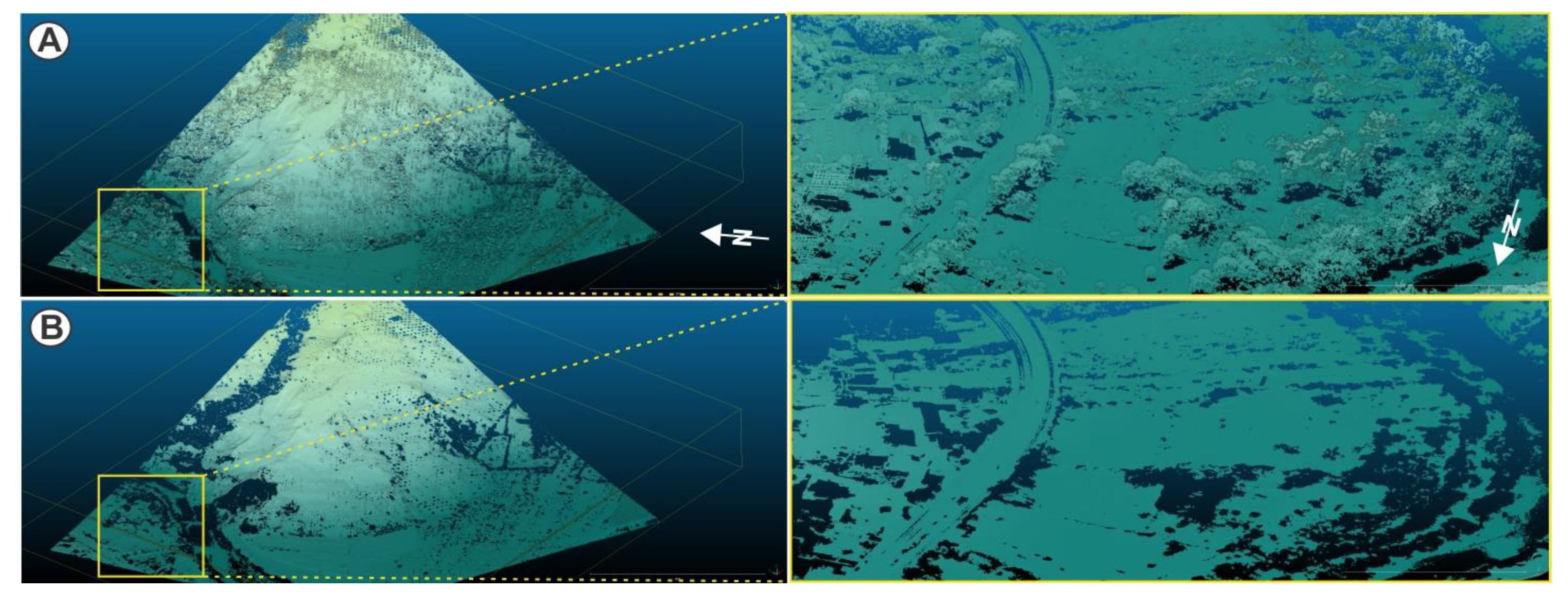
- Digital Terrain Model Generation: The DTM encapsulated the bare earth surface, achieved by filtering out the non-ground points from the previously classified point cloud (Figure 6). This filtration rendered a refined depiction of the natural terrain topography, omitting aboveground attributes. The ultimate gridded representations of the DTM were derived employing a grid-based interpolation technique, specifically Delaunay triangulation, with a designated cell size of 0.25 m.
- 6.
- Data Export: The processed data, the point cloud and the DTM were exported as raster files, facilitating further analysis and utilization in geomorphological evaluation and mapping.
4. Results and Discussion
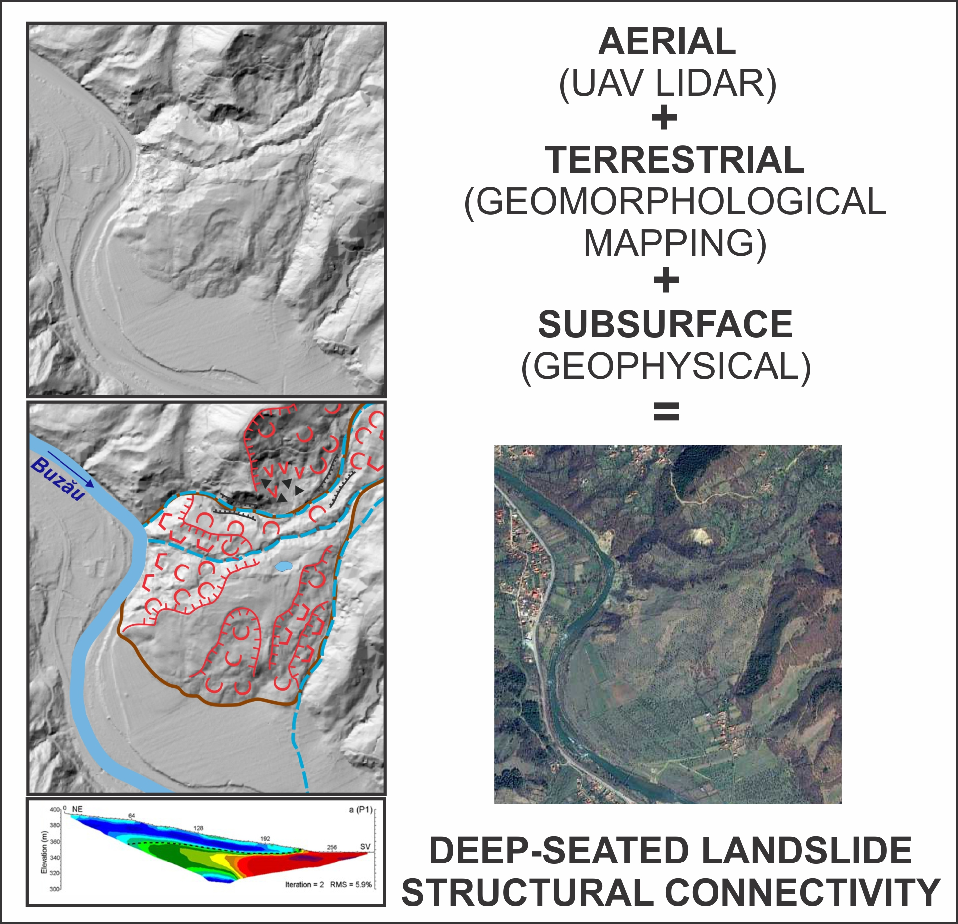
4.1. UAV LiDAR DTM
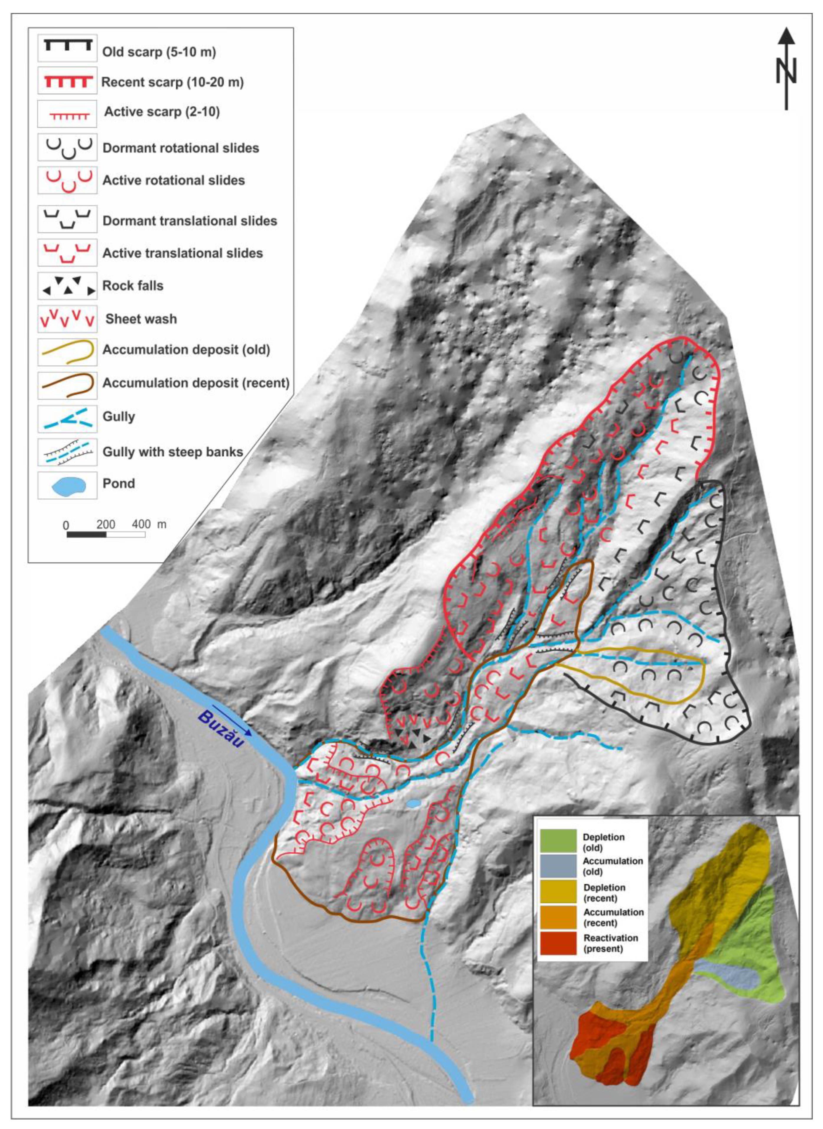
4.2. Geomorphologic Interpretation
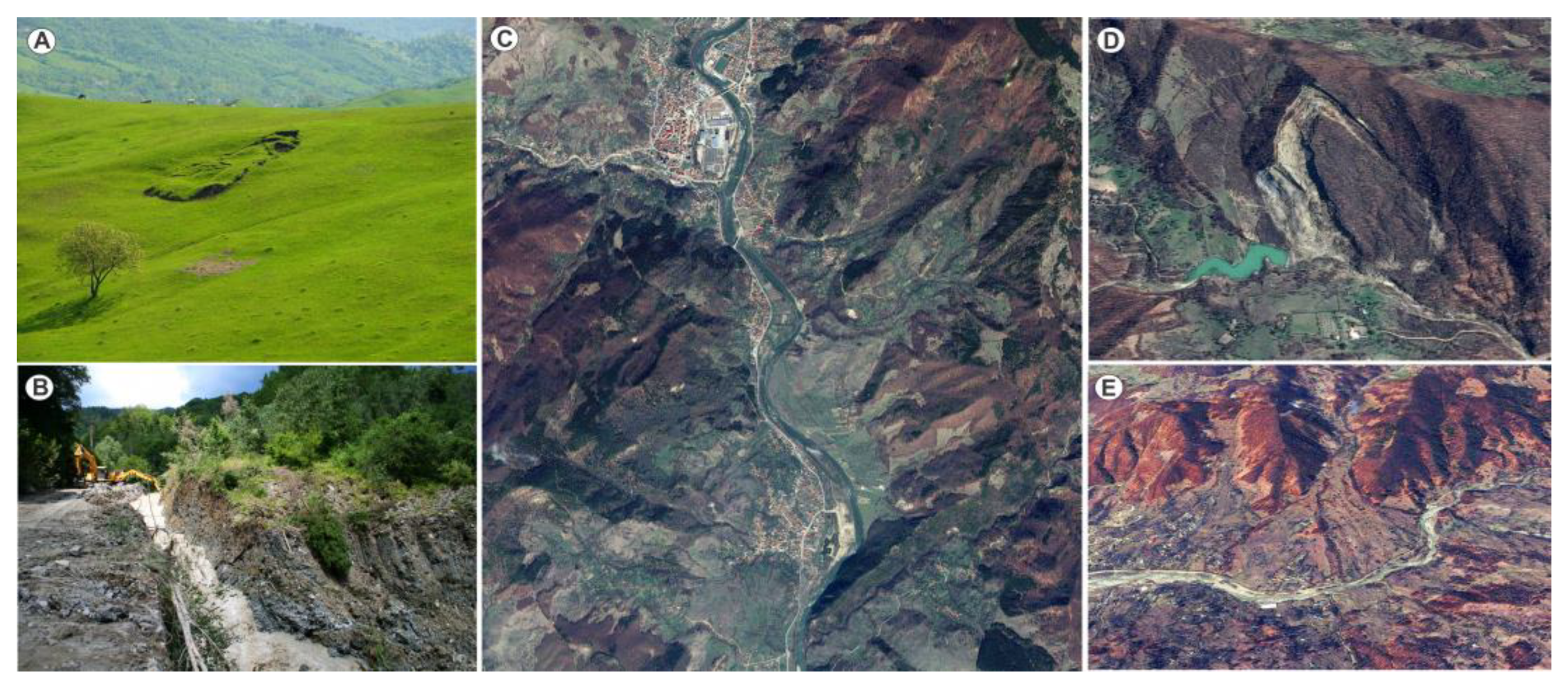
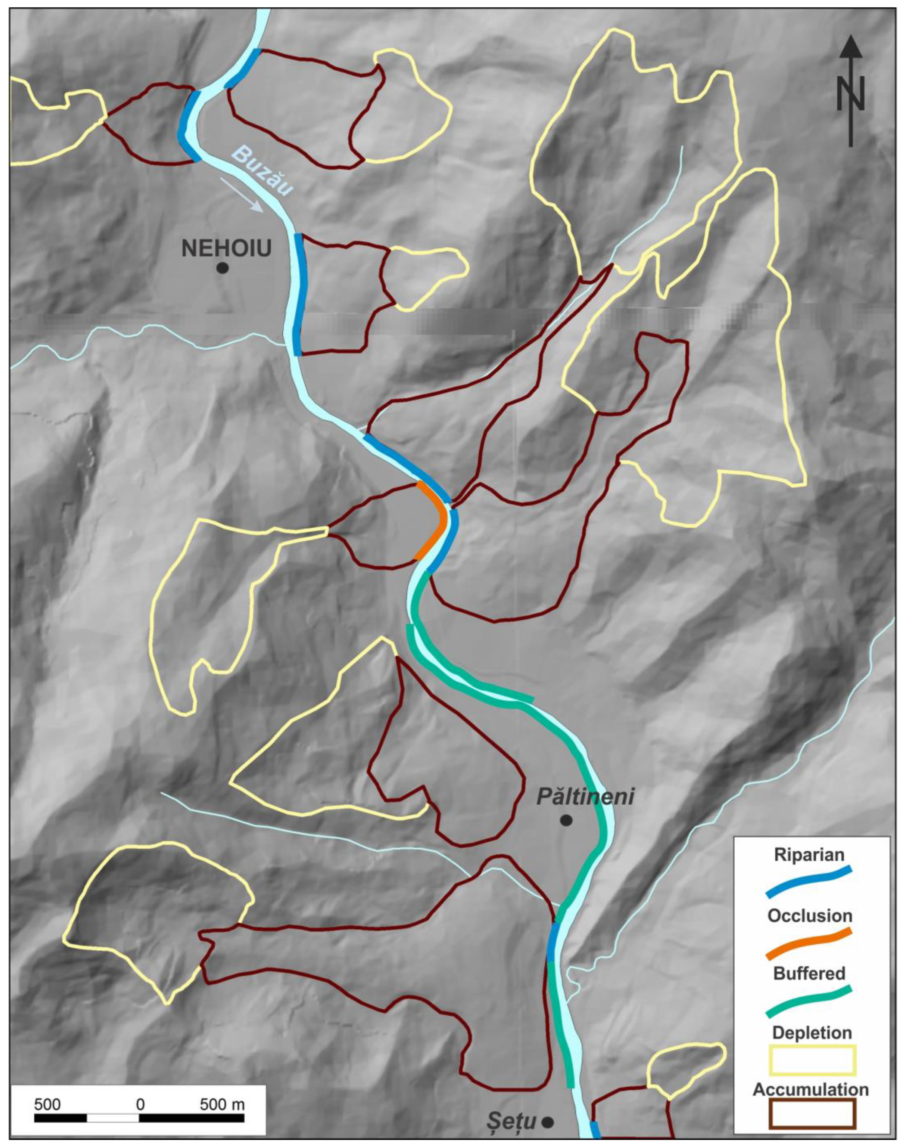
- The dormant ancient landslide: With a buffered geomorphologic impact and a null superior impact surface, the first landslide (which we assume to be a first-time failure, taking into account the morphological characteristics of such processes in the study area, as described by Ielenicz [38]) remained suspended on the slope, without reaching the Buzău Valley. Occurring in the upper catchment of a small, second-order tributary, it developed as an alternation of translational and rotational (mainly retrogressively, towards the main scarp, as the crown was reducing in size) shallow-to-medium-seated landslide (earth, debris and even small rock slides), outlining a 20 ha depletion area, bordered by a 5–10 m scarp, close to the watershed and presently discontinuous, flattened during a longer evolution, and thus difficult to be sharply recognized. All these considerations suggested an older age, expressed in relative terms by comparing it to the following one. The accumulation of the heterogeneous landslide material is presently noticeable through a hummocky landscape marked by scattered, mostly buried large sandstone blocks. The accumulation deposit (2–5 m thick), presently largely flattened and without obvious rugosity (or cracks and fissures), at its maximum extent, advanced progressively for a short distance along the second-order stream and it stopped, remaining suspended. There is no clear evidence as to how long it advanced, but taking into account local morphological features (especially related to the local lateral extension and longitudinal profile), we assumed that the travel distance was short, of the order of some tens of meters.
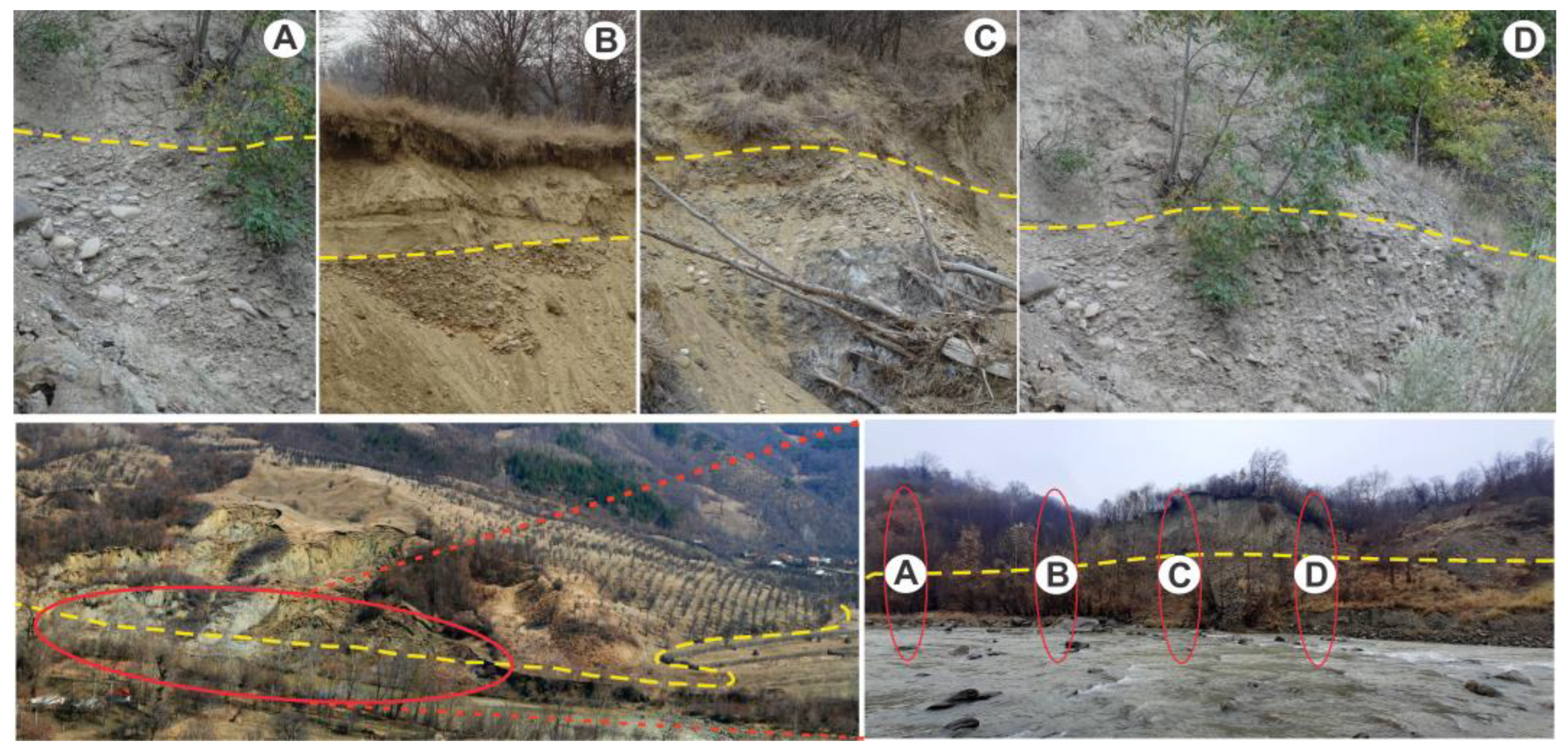
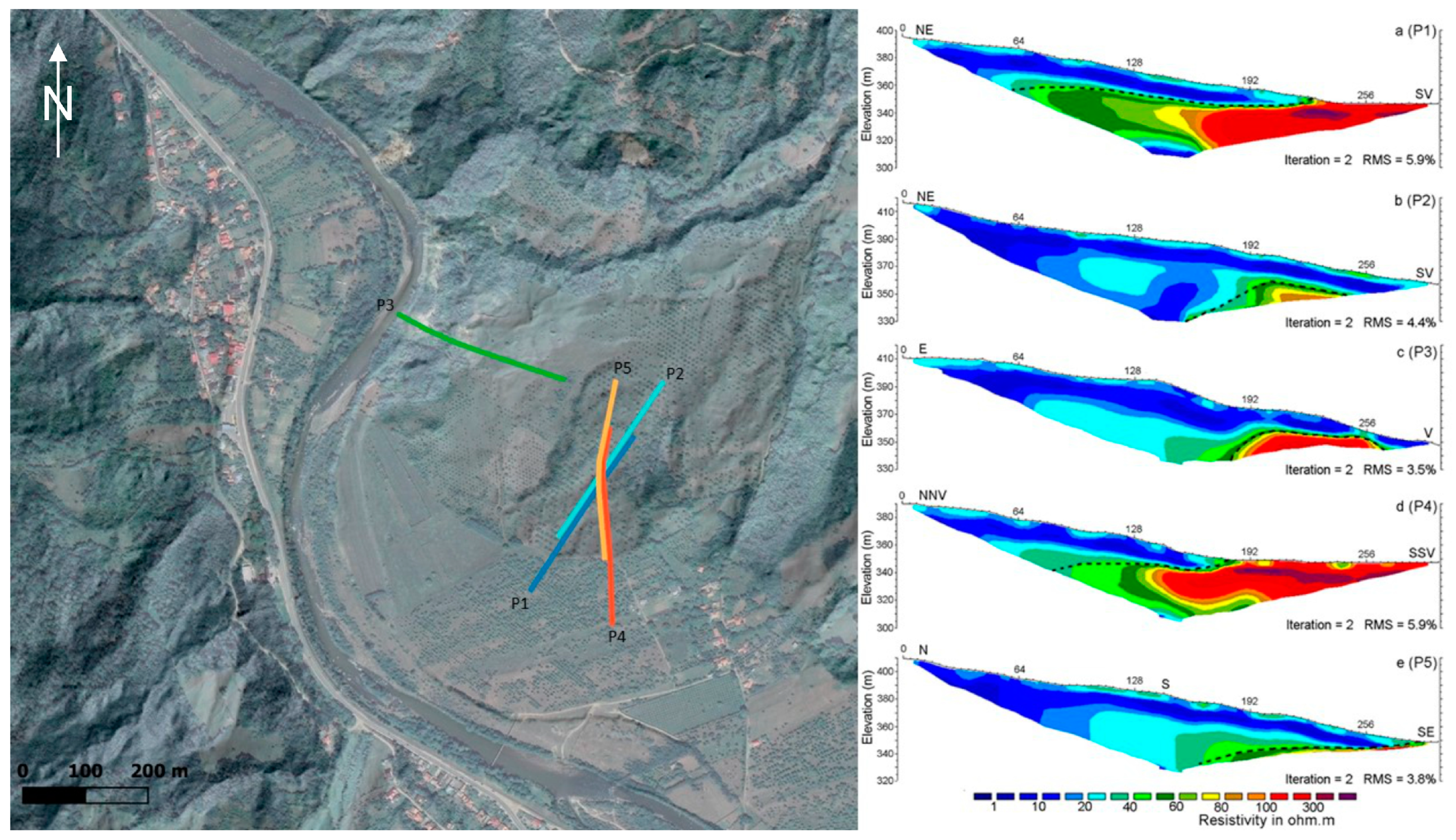
- The dormant recent landslide: This occurred during the time period following the first (old) landslide, but without clear definition of its time span. It progressively affected the entire longitudinal slope profile, along the second-order stream (left tributary of the Buzău River). Its younger age (in comparison with the first one) was estimated by comparing the aspect of the scarps (flattened and faded in the first case, very much visible and even largely active, determined through retrogressive development, in the second case), the overall morphology of the depletion zones (with better outlined erosional and gravitational processes in the case of the recent one, deeper incised and active gullies, especially in the middle sector, where the two accumulation deposits are overlapping, and fresh rock fall accumulations) and the better-pronounced micromorphology and increased overall rugosity (including clear cracks and fissures) of the landslide deposit. Both depletion and accumulation sectors are marked by active processes (erosional—sheet wash, gully erosion—as well as gravitational—rotational and translational shallow debris and earth slides). The elongated scarps (reaching even 10–20 m in height), situated in the immediate vicinity of the watershed, present numerous sectors (2–10 m high) marked by recent activity (debris and rock accumulations at their foot), despite being largely forested. The large extent of the depletion area (60 ha), the 600 m long and the 60–160 m relatively narrow runout channel and the very large terminal accumulation fan (35 ha) indicate a (most likely) sudden occurrence: the 2–5 m debris deposit (in the median part) and an area up to more than 60–70 m thick (in the final, accumulation fan part) moved progressively along half of the entire slope’s longitudinal profile, along the second-order stream, ending with an occlusion geomorphologic impact, during which the Buzău River was shifted with some 500 m westwards, as well as an areal impact surface. The lack of older lateral pressure ridges along the present runout channel or in its immediate vicinity and the compact morphology of the accumulation fan strongly suggest a single pulsation (in comparison, several generations of terminal fans, each one deposited according to a certain pulsation, may be easily witnessed to other similar processes in the immediate vicinity, like the Chirlești earth flow [36]). Meanwhile, this sudden accumulation of landslide deposits on top of alluvial formations were documented through geophysical measurements, as detailed below.
- The presently active sectors: Corresponding to shallow- and medium-seated reactivations (mainly in the rotational form, but also as translational debris slides) of the landslide toe, these sectors are witnessing the reactivation role of slope gravitational and fluvial processes (see Figure 9). The reactivations are conditioned either by the lateral erosion of the Buzău River (the NW one), as a response of the river’s return to its normal hydraulic flow parameters, or by the adaptation of the toe’s steep profile (inclinations of up to 15–25°) to the local base level (S and SE ones; the latter is equally conditioned by erosion exerted by the gully which forms the limit between the landslide deposit and the in situ rock). A similar process of slope undercut due to river lateral erosion was witnessed immediately north, where the toe of an even older, but similar (at least in morphology) debris flow was completely cut by the Buzău River, which straightened its course once the landslide accumulation deposit was removed. With a more reduced magnitude (1–2 ha each), these presently active sectors show a riparian geomorphologic impact and a linear impact surface (the NW one), as well as a buffered geomorphologic impact (S and SE ones, showing no clear physical contact between the landslide toe and the river) with a null impact surface (the landslide, with both its sectors, depletion and accumulation, is geomorphically decoupled by the river channel).

- Independent events or those that change each other’s preparing framework (first an earthquake, triggering, in the context of local amplifications, rock falls and shallow landslides in the vicinity of the ridge, resulting in the accumulation of a potentially unstable deposit, with low cohesion and increased permeability, prone to a subsequent rainfall-induced displacement).
- Coupled events (high-magnitude seismic shaking and co-seismic landslide). Clear signs of earthquake-induced landslides are associated with high-magnitude earthquakes, exceeding Mw > 7, in boh dry and humid conditions [35]. Moreover, knowing that for large, deep-seated landslide initiation, extended periods (7–180 days) with precipitation are needed and the return period of heavy precipitation (FR10) and very heavy precipitation (FR25) range from 30 to 100 years [26,27], one should assume that at least 1–3 times per century, the Vrancea seismic region faces a propitious multi-hazard (large earthquakes and heavy precipitation) scenario, resulting in major geomorphic impacts of deep-seated landslides on river networks.
5. Conclusions and Perspectives
Author Contributions
Funding
Data Availability Statement
Conflicts of Interest
References
- Poljansek, K.; Marin Ferrer, M.; Vernaccini, L.; Marzi, S.; Messina, L. Review of the Sendai Framework Monitor and Sustainable Development Goals Indicators for Their Inclusion into INFORM Global Risk Index; Publications Office of the European Union: Luxembourg, 2019; ISBN 978-92-76-03849-8. [Google Scholar] [CrossRef]
- Shano, L.; Raghuvanshi, T.K.; Meten, M. Landslide susceptibility evaluation and hazard zonation techniques—A review. Geoenviron Disasters 2020, 7, 18. [Google Scholar] [CrossRef]
- Davis, W.M. The geographical cycle. Geogr. J. 1989, 14, 481–504. [Google Scholar] [CrossRef]
- Penk, W. Morphological Analysis of Landforms; McMillian: London, UK, 1953. [Google Scholar]
- King, L. The Morphology of the Earth; Oliver and Boyd: Edinburgh, UK, 1962; p. 726. [Google Scholar]
- Skempton, A.W. Soil mechanics in relation to geology. Proc. Yorks. Geol. Soc. 1953, 29, 33–62. [Google Scholar] [CrossRef]
- Hutchinson, J.N. The Stability of Cliffs Composed of Soft Rocks, with Particular Reference to the Coast of South-East England. Ph.D. Thesis, University of Cambridge, Cambridge, UK, 1965. [Google Scholar]
- Selby, M.J. Dominant geomorphic events in landform evolution. Bull. Int. Assoc. Eng. Geol. 1974, 9, 85–89. [Google Scholar] [CrossRef]
- Carson, M.A.; Kirkby, M.J. Hillslope Form and Process; Cambridge University Press: Cambridge, UK, 1972; 475p. [Google Scholar]
- Crozier, M.J. Landslide Geomorphology: An argument for recognition, with examples from New Zealand. Geomorphology 2010, 120, 3–15. [Google Scholar] [CrossRef]
- Korup, O. Earthquake-triggered landslides—Spatial patterns and impacts. In COGEAR Module 1 Report; Swiss Federal Research Institutes WSL/SLF: Davos, Switzerland, 2010. [Google Scholar]
- Chorley, R.J.; Kennedy, B.A. Physical Geography: A Systems Approach; Prentice Hall: London, UK, 1971. [Google Scholar]
- Poeppl, R.E.; Keesstra, S.D.; Maroulis, J. A conceptual connectivity framework for understanding geomorphic change in human impacted fluvial systems. Geomorphology 2016, 277, 237–250. [Google Scholar] [CrossRef]
- Wohl, E.; Magilligan, F.; Rathburn, S.L. Introduction to the special issue: Connectivity in Geomorphology. Geomorphology 2016, 277, 1–5. [Google Scholar] [CrossRef]
- Wohl, E.; Brierley, G.; Cadol, D.; Coulthard, T.; Covino, T.; Fryirs, K.; Sklar, L. Connectivity as an Emergent Property of Geomorphic Systems. Earth Surf. Process. Landf. 2019, 44, 4–26. [Google Scholar] [CrossRef]
- Bracken, L.J.; Turnbull, L.; Wainwright, J.; Bogaart, P. Sediment connectivity: A framework for understanding sediment transfer at multiple scales. Earth Surf. Process. Landf. 2015, 40, 177–188. [Google Scholar] [CrossRef]
- Cossart, E.; Fressard, M. Assessment of structural sediment connectivity within catchments: Insights from graph theory. Earth Surf. Dyn. 2017, 5, 253–268. [Google Scholar] [CrossRef]
- Heckmann, T.; Schwanghart, W. Geomorphic coupling and sediment connectivity in an alpine catchment—Exploring sediment cascades using graph theory. Geomorphology 2013, 182, 89–103. [Google Scholar] [CrossRef]
- Heckmann, T.; Cavalli, M.; Cerdan, O.; Foerster, S.; Javaux, M.; Lode, E.; Brardinoni, F. Indices of sediment connectivity: Opportunities, challenges and limitations. Earth Sci. Rev. 2018, 187, 77–108. [Google Scholar] [CrossRef]
- Persichillo, M.G.; Bordoni, M.; Cavalli, M.; Crema, S.; Meisina, C. The role of human activities on sediment connectivity of shallow landslides. Catena 2018, 160, 261–274. [Google Scholar] [CrossRef]
- Najafi, S.; Dragovich, D.; Heckmann, T.; Sadeghi, S.H. Sediment connectivity concepts and approaches. Catena 2021, 196, 104880. [Google Scholar] [CrossRef]
- Zingaro, M.; Refice, A.; Giachetta, E.; D’Addabbo, A.; Lovergine, F.; De Pasquale, V.; Capolongo, D. Sediment mobility and connectivity in a catchment: A new mapping approach. Sci. Total Environ. 2019, 672, 763–775. [Google Scholar] [CrossRef] [PubMed]
- Wainwright, J.; Turnbull, L.; Ibrahim, T.G.; Lexartza-Artza, I.; Thornton, S.F.; Brazier, R.E. Linking environmental regimes, space and time: Interpretations of structural and functional connectivity. Geomorphology 2011, 126, 387–404. [Google Scholar] [CrossRef]
- Jain, V.; Tandon, S.K.; Sinha, R. Application of modern geomorphic concepts for understanding the spatio-temporal complexity of the large Ganga river dispersal system. Curr. Sci. 2012, 103–111, 1300–1319. [Google Scholar]
- Micu, M.; Micu, D.; Soldati, M. Mass movements in changing mountainous environments. In Treatise on Geomorphology; Elsevier: Amsterdam, The Netherlands, 2021; ISBN 9780124095489. [Google Scholar] [CrossRef]
- Micu, M. Landslide types and spatial pattern in the Subcarpathian area. In Landform Dynamics and Evolution in Romania; Radoane, M., Vespremeanu-Stroe, A., Eds.; Springer: Berlin/Heidelberg, Germany, 2017; pp. 305–325. [Google Scholar]
- Micu, M.; Micu, D. Landslides morphogenetic complexity in the Buzău Carpathians and Subcarpathians. Implication for hazard assessment. Rom. J. Geogr. 2022, 66, 137–152. [Google Scholar]
- Micu, M. The systematic of landslide processes in the conditions of Romania’s relief. In Landform Dynamics and Evolution in Romania; Radoane, M., Vespremeanu-Stroe, A., Eds.; Springer: Berlin/Heidelberg, Germany, 2017; pp. 249–269. [Google Scholar]
- Sîrbu, F.; Drăguț, L.; Oguchi, T.; Hayakawa, Y.; Micu, M. Scaling land-surface variables for landslide detection. Prog. Earth Planet. Sci. 2019, 6, 44. [Google Scholar] [CrossRef]
- Zumpano, V.; Hussin, H.; Reichenbach, P.; Bãlteanu, D.; Micu, M.; Sterlacchini, S. A landslide susceptibility analysis for Buzãu County, Romania. Rom. J. Geogr. 2014, 58, 9–16. [Google Scholar]
- Brock, J.; Schratz, P.; Petschko, H.; Muenchow, J.; Micu, M.; Brenning, A. The performance of landslide susceptibility models critically depends on the quality of digital elevation models. Geomat. Nat. Hazards Risk 2020, 11, 1075–1092. [Google Scholar] [CrossRef]
- Dornik, A.; Drăguț, L.; Oguchi, T.; Hayakawa, Y.; Micu, M. Influence of sampling design on landslide susceptibility mod-eling in lithologically heterogeneous areas. Sci. Rep. 2022, 12, 2106. [Google Scholar] [CrossRef] [PubMed]
- Havenith, H.; Torgoev, A.; Braun, A.; Schlogel, R.; Micu, M. A new classification of earthquake-induced event sizes based on seismotectonic, topographic, climatic and geologic factors. Geoenvironmental Disasters 2016, 3, 2–24. [Google Scholar] [CrossRef]
- Kumar, V.; Cauchie, L.; Mreyen, A.S.; Micu, M.; Havenith, H.B. Evaluating landslide response in seismic and rainfall regime: A case study from the SE Carpathians, Romania. Nat. Hazards Earth Syst. Sci. 2021, 12, 3767–3788. [Google Scholar] [CrossRef]
- Micu, M.; Micu, D.; Havenith, H.B. Earthquake-induced landslide hazard assessment in the Vrancea Seismic Region (Eastern Carpathians, Romania): Constraints and perspectives. Geomorphology 2023, 427, 108635. [Google Scholar] [CrossRef]
- Jurchescu, M.; Kucsicsa, G.; Micu, M.; Sima, M.; Balteanu, D. Landslide exposure assessment under environmental change in the Romanian Subcarpathians. Stud. Geomorphol. Carpatho Balc. 2020, 53–54, 59–84. [Google Scholar]
- Ielenicz, M. Munţii Ciucaş-Buzău. Studiu Geomorphologic; Editura Academiei Republicii Socialiste România: Bucharest, Romania, 1984; 148p. (In Romanian) [Google Scholar]
- Micu, M.; Bălteanu, D. The Impact of Deep-Seated Landslides on Reservoirs and Rivers in Vrancea Seismic Region. In Landslide Science and Practice: Volume 6: Risk Assessment, Management and Mitigation; Margottini, C., Canuti, P., Sassa, K., Eds.; Springer: Berlin/Heidelberg, Germany, 2013; pp. 117–123. [Google Scholar] [CrossRef]
- Damen, M.; Micu, M.; Zumpano, V.; Van Westen, C.J.; Sijmons, K.; Balteanu, D. Landslide mapping and interpretation: Implications for landslide susceptibility analysis in discontinuous data environment. In Proceedings of the International Con-ference Analysis and Management of Changing Risks for Natural Hazards, Padua, Italy, 18–19 November 2014; pp. 177–186. [Google Scholar]
- Korup, O. Geomorphic imprint of landslides on alpine river systems, southwest New Zealand. Earth Surf. Process. Landf. 2005, 30, 783–800. [Google Scholar] [CrossRef]
- Bălteanu, D.; Micu, M. Morphodynamics of the Chirleşti mudflow (Buzău Mountains). Rom. J. Geogr. 2012, 56, 2. [Google Scholar]
- Dumitrescu, I.; Săndulescu, M.; Bandrabur, T. Geological Map of Romania 1:200,000, Sheet 29-Covasna; Institute of Geology: Bucharest, Romania, 1970. [Google Scholar]
- Posea, G. Glissement, méandres et voies de communication dans la Valée de Buzau. In Travaux du Symposium International de Géomorphologie Appliquée: Bucarest, Mai 1967; Institut de Géologie et de Géographie de l’Académie de la République Socialiste de Roumanie: Bucharest, Romania, 1969. [Google Scholar]
- Ielenicz, M. Contributii la studiul porniturilor de teren din bazinul superior al Buzaului. Rev. Pădurilor 1969, 2, 73–76. (In Romanian) [Google Scholar]
- Sandu, M. General Geomorphological Map 1:25,000, Paltineni Sheet; Institute of Geography: Bucharest, Romania, 1993. [Google Scholar]
- Zhang, W.; Qi, J.; Wan, P.; Wang, H.; Xie, D.; Wang, X.; Yan, G. An Easy-to-Use Airborne LiDAR Data Filtering Method Based on Cloth Simulation. Remote Sens. 2016, 8, 501. [Google Scholar] [CrossRef]
- Reynolds, J.M. An Introduction to Applied and Environmental Geophysics; Wiley and Sons: Chichester, UK, 1997. [Google Scholar]
- Perronne, A.; Lapenna, V.; Piscitelli, S. Electrical resistivity tomography technique for landslide investigation: A review. Earth-Sci. Rev. 2014, 135, 65–82. [Google Scholar] [CrossRef]
- Hack, R. Geophysics for slope stability. Surv. Geophys. 2000, 21, 423–448. [Google Scholar] [CrossRef]
- Loke, M.; Barker, R. Practical techniques for 3D resistivity surveys and data inversions 1. Geophys. Prospect. 1996, 44, 499–523. [Google Scholar] [CrossRef]
- Mreyen, A.S.; Cauchie, L.; Micu, M.; Onaca, A.; Havenith, H.B. Multiple geophysical investigations to characterize massive slope failure deposits: Application to the Balta rockslide, Carpathians. Geophys. J. Int. 2021, 225, 1032–1047. [Google Scholar] [CrossRef]
- Micu, M.; Bălteanu, D. A deep-seated landslide dam in the Siriu Reservoir, Bend Carpathians—Romania. Landslides 2013, 10, 323–329. [Google Scholar] [CrossRef]


| Aspect | Multi-Rotor Drone | Fixed-Wing Drone (Trinity f90+) |
|---|---|---|
| Flight time | Shorter flight times due to energy demands | Longer flight times due to aerodynamic design |
| Maneuverability | Highly maneuverable, can hover and change directions quickly | Less maneuverable, requires space for takeoff and landing |
| Coverage | Suitable for smaller, more detailed areas | Suitable for larger area coverage |
| Terrain adaptability | Better suited for following terrain in areas with high relief amplitude due to hover and slow-flight capabilities | Challenged by areas with high relief amplitude as it requires space and time for the drone to adjust altitude, especially at a speed of about 18 m/s |
| Aspect | Mission 1 | Mission 2 | Mission 3 | Mission 4 | Mission 5 |
|---|---|---|---|---|---|
| UAV model | Trinity f90+ | ||||
| Sensor model | Qube 240 | ||||
| Flight height (m) | 105 | 110 | 85 | 85 | 100 |
| Number of points in cloud | 231,785,663 | 224,859,106 | 148,990,858 | 304,908,982 | 224,603,685 |
| Point cloud resolution (points/m2) | 90 | 85 | 110 | 110 | 95 |
| Surface (ha) | 268 | 272 | 257 | 237 | 260 |
| DEM resolution | 0.25 | 0.25 | 0.25 | 0.25 | 0.25 |
| Parameter Name | Description | Value | Options/Units |
|---|---|---|---|
| General Parameters | |||
| Scenes | Set the scene type for the point clouds to determine the terrain’s rigidness | Steep slope | Steep slope, relief, flat |
| Slope Processing | This option fine-tunes the cloth fit to better match ground measurements | On | On/Off |
| Advanced Parameters | |||
| Cloth Resolution | Refers to the grid size of the cloth used to cover the terrain | 0.6 | Units of point clouds |
| Max Iterations | Refers to the maximum iteration times for terrain simulation | 600 | |
| Classification threshold | A threshold to classify the point clouds into ground and non-ground parts based on the distances between points and the simulated terrain | 0.5 | Units of point clouds |
| N° | Coupling | Geomorphic Impact | Impact Surface | Trigger | Single/Multi-Hazard | Recurrence |
|---|---|---|---|---|---|---|
| 1 | Decoupled/ indirectly coupled | Buffered | Nil |
|
| 1–5 years |
| 2 | Directly coupled | Occlusion/ blockage/ obliteration | Areal/ linear |
Single (1–3 months antecedent wet intervals or 0–72 h heavy precipitation exceeding 1–2 times the monthly averages); Mw > 7 earthquake (in dry/humid conditions)
Multiple (combination of above) |
Single hazard
| 1–3 per century |
| 3 | Directly coupled | Riparian, suspended | Linear/ punctual |
Mw > 4.5 earthquake (with site effects) |
| 1–5 years |
Disclaimer/Publisher’s Note: The statements, opinions and data contained in all publications are solely those of the individual author(s) and contributor(s) and not of MDPI and/or the editor(s). MDPI and/or the editor(s) disclaim responsibility for any injury to people or property resulting from any ideas, methods, instructions or products referred to in the content. |
© 2023 by the authors. Licensee MDPI, Basel, Switzerland. This article is an open access article distributed under the terms and conditions of the Creative Commons Attribution (CC BY) license (https://creativecommons.org/licenses/by/4.0/).
Share and Cite
Micu, M.; Vasile, M.; Miron, F.; Onaca, A.; Sîrbu, F.; Skyline Drones Team. Deciphering Complex Morphology and Structural Connectivity of High-Magnitude Deep-Seated Landslides via Airborne Laser Scanning: A Case Study in the Vrancea Seismic Region, Romanian Carpathians. Remote Sens. 2023, 15, 5286. https://doi.org/10.3390/rs15225286
Micu M, Vasile M, Miron F, Onaca A, Sîrbu F, Skyline Drones Team. Deciphering Complex Morphology and Structural Connectivity of High-Magnitude Deep-Seated Landslides via Airborne Laser Scanning: A Case Study in the Vrancea Seismic Region, Romanian Carpathians. Remote Sensing. 2023; 15(22):5286. https://doi.org/10.3390/rs15225286
Chicago/Turabian StyleMicu, Mihai, Mirela Vasile, Florin Miron, Alexandru Onaca, Flavius Sîrbu, and Skyline Drones Team. 2023. "Deciphering Complex Morphology and Structural Connectivity of High-Magnitude Deep-Seated Landslides via Airborne Laser Scanning: A Case Study in the Vrancea Seismic Region, Romanian Carpathians" Remote Sensing 15, no. 22: 5286. https://doi.org/10.3390/rs15225286