

Public Administration and Landowners Facing Real Estate Cadastre Modernization: A Win-Lose or Win-Win Situation?

1
Department of Integrated Geodesy and Cartography, AGH University of Science and Technology, 30-059 Kraków, Poland
2
Institute of Earth Sciences, University of Silesia in Katowice, 40-007 Katowice, Poland
3
Global Justice Program, Yale University, New Haven, CT 06520, USA
4
Center for Tourism Research, Wakayama University, Wakayama 640-8510, Japan
*
Author to whom correspondence should be addressed.
Resources 2023, 12(6), 73; https://doi.org/10.3390/resources12060073
Submission received: 20 April 2023
/
Revised: 9 June 2023
/
Accepted: 14 June 2023
/
Published: 20 June 2023
(This article belongs to the Special Issue Recent Trends in Resources considering Sustainability, Economy, and Corporate Social Responsibility)
Abstract
:Keeping the real estate cadastre’s database up to date is a very important process. The scope of the modernization works includes, among other things, fieldwork and office (chamber) work carried out by surveyors to update information about land and buildings. Therefore, modernization may result in changes to plot areas; changes to the marking of plots and land use (and, consequently, a change in the property tax); and the disclosure or deletion of buildings and premises, as well as changes to their technical data. The research, based on a case study (rural municipality Serniki, Poland), and supported by a literature review, remote sensing, and digital photogrammetry, clearly showed the importance of initiating the cadastre modernization procedure and obtaining funds for this purpose, which will be beneficial for both parties. Landowners will gain by bringing the current image of their real estate closer to the actual state (e.g., by paying taxes for the real utility of the land), while administrative units will become the beneficiaries of higher tax revenues (up to over 500%). Thus, the analysis carried out on the case study shows positive effects for both parties, and justifies the financial outlay incurred by the administrative units for this process. Moreover, the analysis revealed that, due to the possibility of obtaining funding from other sources, the cost to the public administration may be marginal. Thus, the cadastre modernization procedure should be integrated into regional and national policies.
1. Introduction
One of the main goals of a modern state is to protect the property rights of its citizens [1]. Among those property rights, real estate, including land, is one of the key elements [2,3,4,5,6,7]. Securing the ownership rights to land that is owned, including a legal determination of the scope of the ownership rights, is one of the fundamental functions of the real estate cadastre [6,8,9,10,11,12,13,14,15]. New technological possibilities allow geo-information systems to be adapted to the requirements and needs of society [16]; however, the data it contains must be up-to-date [17]. That is where a real estate cadastre can perform its full function. The process of updating the real estate cadastre database is an important activity for many countries [5,15,18,19,20,21,22,23,24]. Archival maps and other historical cadastral materials are usually used in the process of building a modern real estate cadastre [25,26,27,28,29,30]. However, the current form of real estate cadastre in developed countries is a modern database, maintained, fed, and made available within an information and communications technology (ICT) system [15,31,32,33,34]. It is also notable that, in many countries, work is underway—and is sometimes already advanced—towards extending cadastral information to both the ground and underground zones, i.e., the creation of a 3D cadastre [15,35,36,37,38,39,40]. There are also many countries, also in Europe, where the real estate cadastre is not yet well developed. These include, in particular, the countries of Eastern and Central Europe, where this state of affairs has been caused by many years of neglect after World War II, combined with a lack of actual independence and poor financial conditions [41,42,43]. A modern real estate cadastre, in Poland and other countries, is the basic information system about an area, created in ICT form. The real estate cadastre (also referred to in Poland as the land and building register; see Act, 1989) should ensure the collection, updating, and sharing of information about land, buildings, premises, and their owners, as well as about other entities that own or manage land, buildings, or premises (see e.g., [44,45]). This system should ensure the interoperability of data within the framework of the spatial information structure [1,7,13,24,46,47]. The real estate cadastre is used to provide necessary data to many organs and branches of the economy, and the information it contains is used for land and mortgage registers, spatial and economic planning, farm records, tax and benefits, public statistics, and real estate management. Thus, the data from the real estate cadastre forms, among other things, a central pillar for determining the level of taxes and benefits, the beneficiary of which is the commune. For the real estate cadastre to be useful in implementing these purposes, it must be up-to-date and standardized and, above all, guarantee the reliability of the data it contains. New information on changes to the cadastral data is entered into the real estate cadastre either using an ongoing update of the cadastre or using a modernization of the cadastre. The database of the real estate cadastre is updated on an ongoing basis through individual surveying work. However, the ongoing updating of this database is insufficient for the functions of the real estate cadastre to be fully realized. A comprehensive update of the cadastral data, which takes place during the modernization of the cadastre, is also necessary. Modernization of the cadastral system is an essential tool to ensure both the continuity and the timeliness of cadastral data [23,48,49,50]. Cadastre modernization plays a particular role in bringing cadastre data resources up to date. Modernization therefore usually covers the complex area of the municipality (it is a registration unit, consisting of registration precincts). Comprehensive updating of registration data (cadastral data) takes place during the modernization of land and building records. The real estate cadastre database is also updated on an ongoing basis through individual geodetic works. However, the current updating of the cadastre is not enough for the real estate cadastre’s functions to be fully implemented. The procedure of modernizing the cadastre plays a special role in the pursuit of the current stock of registration data. The modernization of land records most often covers a comprehensive area of a commune (constituting a record unit, composed of record precincts). It is also sometimes limited to a single registration area or can cover several communes. The size of the area usually depends on the financial capacity of the district the administrative official oversees, and is possibly supported by subsidies obtained for this purpose from the European Union or the central government.
From the point of view of a commune’s financial interests, the current state of the real estate cadastre database is extremely important, especially with regard to two considerations: compliance with the actual state of the land for registration, and the proper determination of the method and range of land use [7,24,29,51,52,53,54]. The type of land use determines the rate of real estate tax and the taxes on agricultural and forest land [5,55,56,57].
The purpose of the paper is to examine the role of the local government units that maintain the real estate cadastre, as well as to demonstrate the relevance of the role of local government, in initiating the procedure for modernizing the cadastre and raising funds for this purpose. To resolve this research problem, quantitative studies have been carried out, linking the change in the extent and area of land use (resulting from a comprehensive modernization of the cadastre in the municipality) and the financial implications (profit and loss balance) for both the municipality and landowners. For this purpose, the rural municipality Serniki in Lublin Voivodeship (Poland) was subjected to thorough analysis. Serniki is a representative rural municipality, as it is a typical case in the areas of southern and eastern Poland, where the cadastre base is severely outdated, especially in terms of land use.
Many countries (even developed ones), including Poland (see e.g., NIK, 2022), lack financial resources first and foremost, but also human resources and information and communications technology for the modernization process; thus, the analysis conducted in this article shows the positive effects for both sides and justifies the financial outlays incurred for this process by administrative units.
2. Background
2.1. Cadastre Modernization Procedure
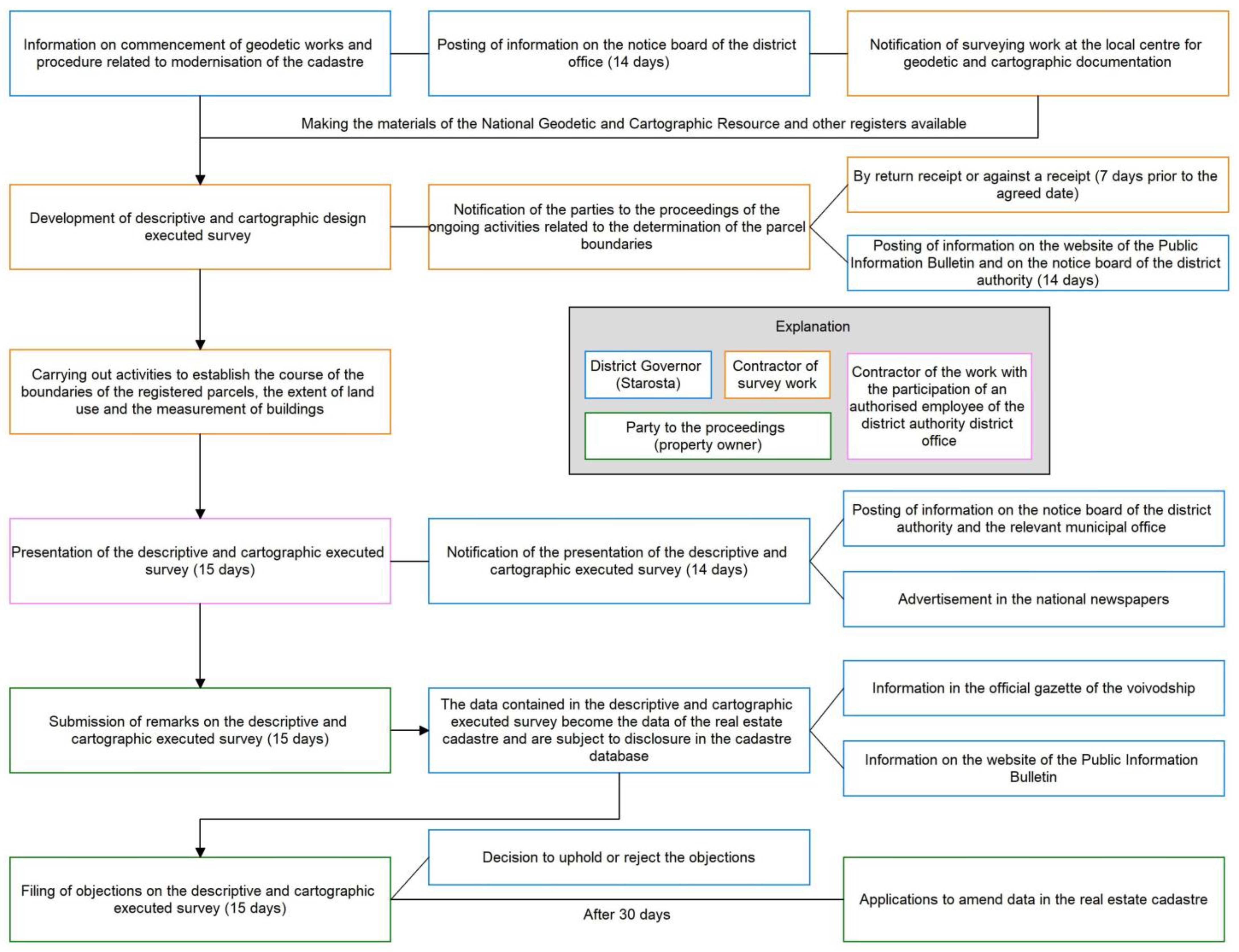
The cadastre modernization procedure is a formalized set of technical, organizational, and administrative activities requiring the cooperation of three interested parties. These are the surveying administration represented by the starost, the surveying contractor, and the landowner (the so-called party to the proceedings). Their roles are interlinked through strict legal and technical procedures. Below is a detailed diagram showing the course of such a procedure in Poland (Figure 1).
For the following considerations, modernization should be understood primarily as the effect of certain activities, consisting of supplementing (updating) the database with missing information, as well as modifying the existing data in case of loss of validity. The modernization operation also results in the improvement of information flow structure, and the implementation or improvement of functioning of the information system in which the cadastre is maintained. However, these aspects remain beyond the scope of this study. Due to the history, development, and specificity of a given country and its laws, the process and effects of cadastre modernization can take different forms. In this article, selected issues in this area will be discussed in the example of Poland.
2.2. Cadastre System in Poland
Poland is a country that, even though it is currently counted among the developed countries, has seen a significant delay in the development and timeliness of its real estate cadastre [23,30,49,57,58,59]. The reason for this is the fact that over its history, Poland has experienced long periods of time in which it was not an independent country with a properly developing economy. These periods included, for example, the 123 years of the Partitions of Poland between the three neighboring powers from 1795 to 1918, as well as World War II from 1939 to 1945, and the time after World War II, when Poland was subordinated to the Soviet sphere of influence (for this reason, the economy did not develop properly from 1945 to 1989).
It was not until 1989 that the first milestone in the economic development of Poland occurred, namely the political transformation of the country. Another important fact was the accession of Poland to the EU in 2004 and the adoption of the INSPIRE Directive, the main objective of which was to adopt a multidimensional view of the cadastre, e.g., one which took various aspects into consideration, including fiscal, legal, economic, spatial planning, and statistical [49,59]. The consequence of these facts was a thorough reconstruction of Polish legislation in the field of geodesy and cartography, adapting it to EU standards, as well as a significant inflow of financial resources from the European Union structures, building special purpose funds for the modernization of the real estate cadastre databases, among other considerations.
For these reasons, in Poland, to this day, there is no uniformly complete and up-to-date real property cadastre. Real estate cadastre databases in large areas of the country are characterized by a lack of information on buildings, and thus by a lack of updated land use statuses which would generate higher taxes for the municipality.
In Poland, the real estate cadastre, based on its authority in legal acts, is considered the basis for the functioning of many areas of the economy, such as economic planning, spatial planning, real estate management, public statistics, land registers, farm registers, and, above all, in terms of the thematic aspect of the article, the assessment of taxes and benefits [60]. All of the information indicated above is contained in the cadastral report, which consists of databases of the real estate cadastre and documents justifying entries in the databases.
In countries where a complete cadastre has not yet been established, its incompleteness is a significant problem (which is also revealed by this study). For some areas of Poland, the cadastre is still incomplete [19,49,55,58,59,61,62,63]. In Poland, this problem mainly concerns buildings. In most cases, until 2001, buildings were not registered in the real estate cadastre in Poland at all. To some extent, buildings existed only on maps. They were only graphic objects, without descriptive data. Buildings were also not topologically connected with a cadastral parcel; therefore, it was not possible to update the development of a parcel on their basis.
The process of disclosing buildings in the real property cadastre began to accelerate only after Poland’s accession to the European Union and, as a consequence, in the face of the necessity to apply the Directive of the European Parliament of 14 March 2007 establishing an Infrastructure for Spatial Information (SDI) in the Community (INSPIRE) [64]. The effect of the directive was the enactment of the Spatial Data Infrastructure Act of 4 March 2010 (Act on Spatial Data Infrastructure of 4 March 2010) in Poland, followed by the adoption and amendment of subsequent national laws and regulations, including those specifying the rules for disclosure of buildings in the real estate cadastre. It should be clearly emphasized that only the disclosure of the building in the cadastre provides the basis for updating the type and extent of land use, which can result in a change in the amount of taxes.
3. Study Area, Data and Methods
3.1. Study Area
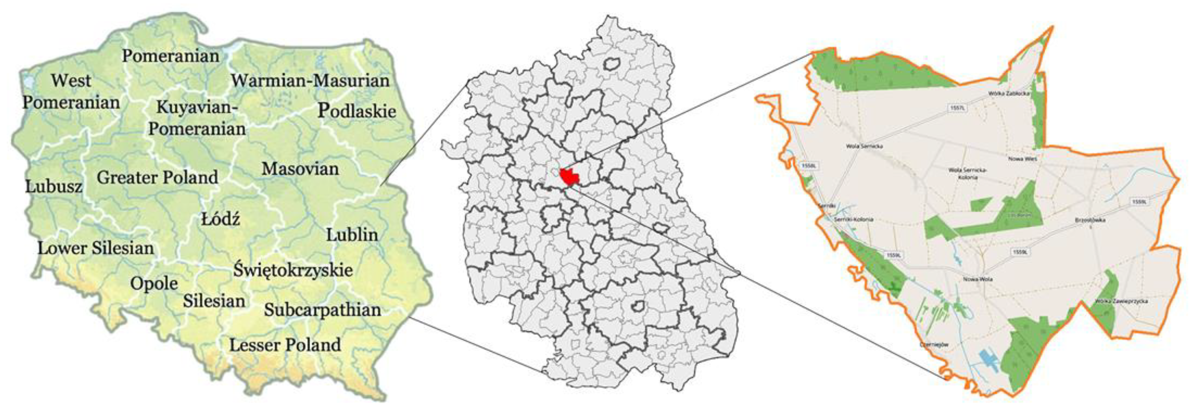
The municipality of Serniki was selected to conduct the study. Serniki commune is a cadastral unit located in the Lubartow district of the Lublin Voivodeship (Figure 2); approximately 6 km south-east of Lubartow and 22 km north of the regional capital Lublin.
The dominant economic activity in the municipality is agriculture, despite the low value of productive space and the predominance of class IV soils. Rye and potatoes predominate among crops. Non-agricultural areas of the economy do not develop significantly in this municipality. Entities engaged in trade and construction operate here, but they focus on meeting the needs of the local population and agriculture.
The registration unit of Serniki is a rural commune. It consists of 10 registration precincts (villages), which are covered by the cadastre being modernized. Comprehensive statistical data for the Serniki commune as of 2019 (before modernization) are summarized in Table 1. Detailed geodetic data concerning the basic unit of settlement registration in the Serniki commune are presented in Table 2.
3.2. Data: Modernization of the Cadastre in Poland—Case Study of Serniki Commune
The process of cadastre modernization is initiated and organizationally carried out by the district administrative official (starosta), as the authority responsible for the real estate cadastre. The second participant in the cadastre modernization process is the geodetic contractor authorized by the starosta to conduct technical activities, while the third participant is the registration entity, i.e., the landowner. Their actions alternate and require constant cooperation, as shown in the following diagram (see Figure 1).
In recent decades, modern photogrammetric technologies have contributed significantly to the qualitative and quantitative improvement of the real estate cadastre. Orthophotos were used in Poland as early as the 1970s, and in the 1990s they were officially added to the National Geodetic and Cartographic Resource Base. However, only a significant improvement in their quality and accessibility, which took place in the twenty-first century, meant that they can now be used widely in the modernization of cadastres. The field pixel value of the digital orthophoto map used today is 0.07 m. Decisions to modernize land and building records using photogrammetric measurements are most often related to time and economy. Photogrammetric measurement is a very cost-effective solution; therefore, it is used in modernization processes, which cover large areas. An example of the use of a high-resolution orthophoto map is the modernization of the Serniki cadastre records carried out in the research facility, which forms the basis for this article. Geodetic measurements are carried out using a digital orthophoto map and belong to the group known as “geodetic cartometry measurements” (2D). It is a less accurate method than the measurements made using the stereoscopic (3D) model; however, due to the speed of this type of measurement, it appears to be the best technology for determining the range of land use. It should be remembered that during the modernization of the cadastre, defining the type of land use follows the stage in which the registration parcels’ boundaries are measured and established (which requires higher precision in determining the coordinates of the cadastral parcel’s boundary points).
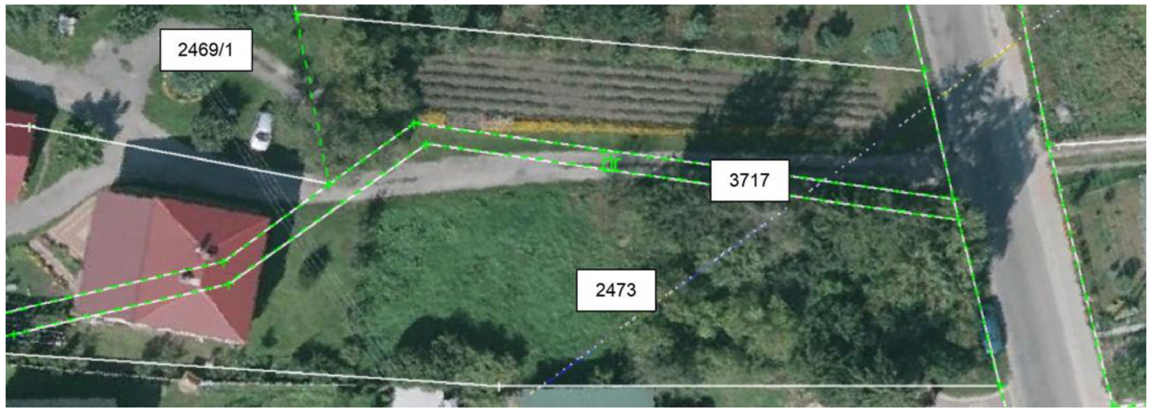
The photogrammetric method is also associated with several other limitations. These result, for example, from the plot or the breakpoints of land use boundaries not being visible because they have been obscured by the tree canopy, buildings, or other elements of the spatial infrastructure. Despite these limitations, the orthophoto map appears to be a valuable product for updating the range and size of land use. It introduces a form of automation. During the upgrade procedure, the test area often translates into many hectares and thousands of parcels requiring measurement. The orthophoto map allows a contractor to assess the situation in the field from their monitor screen, and check it directly with the available source materials from geodetic and cartographic resources, for example, a cadastral map. Therefore, the orthophotomap can be used to efficiently develop a working database in the field. The best results are achieved when an orthophotomap is overlaid with a calibrated raster or vector map [67]. This combination of data sources—orthophotomap and cartographic map—is an excellent method to assess the compliance of the situation in the field, which is visible on the orthophotomap and in the cartographic situation, and presented on the cadastral map intended for an update as part of the modernization of the cadastre [68]. An example of the use of this relationship is presented in Figure 3.
The boundary lines of the plot of land indicated by 3717, which should be used as a road (dr), according to the land registry map before modernization, clearly do not match the situation on the ground, as visible on the orthophotomap. As part of the modernization of the cadastre, all such discrepancies (sometimes many of them) are quickly identified and, after measurements are taken, removed.
3.3. Methods
Due to the broad scope of the study, it was decided to use a variety of research methods. They are described below with an indication of which part of the paper contains the results obtained through their use. The following research methods were used in the study:
- ▪
- Critical analysis (analysis of the literature on cadastre modernization in the world and Poland, taking into account the chronology of changes), particularly evident in the Introduction and Background sections.
- ▪
- Quantitative analysis of the geometric cadastral database. Modernization was carried out with the use of a digital orthophoto map (GSD = 0.07 m), which significantly influenced the character of changes introduced to the resource. The changes that took place during the modernization procedure of the Serniki cadastral unit are presented by comparing numerical data and their graphical presentations.
- ▪
- Analysis of changes in land use cadastral data. This is an inseparable and very important part of modernization works aimed at the creation and modification of digital data sets concerning land use and classification contours and thus revealing and modifying land use surface fields.
- ▪
- Analysis of changes in the building registration data. One of the purposes of the land and building registration modernization procedure is to acquire and complete digital spatial data sets concerning buildings and objects permanently associated with the buildings. Such activities were carried out in the course of the modernization of the Serniki cadastral unit.
- ▪
- Economic (financial) analysis of the modernization process. The procedure of modernization of the land and building registration carried out in the evidential unit of Serniki has a direct impact and introduces significant changes for the municipality. Calculations were made based on respective tax amounts, before and after modernization. The land and building registration provide the data which are the basis for the tax and benefit assessment. This undoubtedly generates significant changes regarding the calculation of agricultural, forestry, and real estate taxes, which is presented in the Results section.
- ▪
- A comparative analysis before and after modernization, especially visible in the Results and Discussion section.
4. Results
4.1. Geodetic Results as an Effect of the Real Estate Cadastre Modernization
The issue of verifying land use and updating its scope is an important element of the modernization of the cadastre. Depending on the national legislation, this can be a more complex or less complex problem. Unfortunately, in Poland, it is a very complex problem, caused by both complicated legal provisions and the instability of these provisions over time.
The effect of the modernization of the cadastre, in terms of land use, was the creation of a working database and the modification of out-of-date data sets for the range of land use, along with the classification of the contours of agricultural land, and the resulting disclosure or modification of the area of land use. In this respect, significant changes were made during the modernization of the Serniki commune’s cadastre. The basic source of registration data concerning the contours of land use was a cadastral map and unit surveys obtained from the state geodetic and cartographic resources. The information collected in these resources was verified by the contractor using an orthophotomap and a field survey. Thus, the numerical description of the contours of the land used by the contractor was obtained partly by geodetic field measurements, but mainly by cartometric measurements made on the orthophotomap, while taking into account the image of the raster cadastral map before the cadastre’s modernization.
The numerical effects of these works showed the changes that took place during the modernization works. Table 3, Table 4 and Table 5 summarize the values of the areas of individual groups of the types of land use that were disclosed in the geometric database of the Serniki commune comparing land use areas before and after the modernization works.
An analysis of the results from Table 3 shows a significant overall increase (due to the modernization process) in the area of agricultural land used: from 332 ha to 6159 ha (over 18 times). This indicates the degree of obsolescence of the real estate cadastre’s database prior to modernization. The greatest increase in area (more than 16 times) was observed for arable land (R). Built-up agricultural land (Br) increased its area almost seven times, from 36 to 241 ha.
Changes in the area within forest land (Table 4) also indicated the huge scale of error in the real estate cadastre’s database before modernization. There was a significant increase in the geometric database of forest land from 290 to 1079 ha.
Built-up and urbanized land, summarized in Table 5, is not represented by large amounts in the Serniki commune, as it is a rural commune with low population density. However, the more than four-fold increase in area for this land use confirms a large imperfection in the real estate cadastre’s database for the commune before the modernization, and this justified the investment of financial resources in carrying it out.
4.2. Financial Results as an Effect of the Real Estate Cadastre Modernization
In terms of finance, the modernization of the real estate cadastre brings tangible benefits to the communes covered by this procedure. It is the real estate cadastre that is the reference database that forms the basis for assessing taxes and benefits for the municipality. Tax liabilities for the commune can be divided into three groups by the use of land listed in Table 3, Table 4 and Table 5:
- ▪
- Agricultural tax is applied to land classified in the cadastre as agricultural land, except land used for business activity other than agricultural activity [69]. It should be emphasized here that developed agricultural land (Br) belongs to the agricultural land group, which is important in terms of the tax rate.
- ▪
- Forest tax is levied on forests classified in the register of land and buildings as forest land. The basis for taxing forest land is the area of forest, expressed in hectares, indicated by the real estate cadastre [70].
- ▪
- Real estate tax applies to ‘others’, to which ‘built-up and urbanized land’ belong. The tax base is the area indicated by the real estate cadastre [71].
The commune, as the local government body, sets the tax rates; however, these must be within the limits set by the central legislation. In the analyzed research study area, the tax rate amounts were shaped in the manner presented in Table 6.
From the tax rates presented in Table 6, it is possible to determine what financial benefits will be obtained by the commune as the beneficiary of agricultural, forest, and real estate taxes related to the updating of land use after the modernization of the real estate cadastre (Table 7).
As can be seen from the data in Table 7, the greatest potential increase in the tax amount was generated by the correct verification (modernization) of residential areas (B)—an 2.5-fold increase. It should be emphasized that the commune constituting the research study area is a rural commune, so it contains relatively small amounts of such land (residential areas, B). Along with an increase in the population density of the commune, and as well as the fact that the owners depart from agricultural production, the amount of this land (B) will show a significant increase. There is no doubt that such an extensive update of the registration data, which is the procedure for modernizing the real estate cadastre, generates positive effects for the commune, due to the increase in tax liabilities of registration entities (landowners), resulting in an increase in financial revenues for the commune.
4.3. Distinction of Land Use and the Tax Consequences of It for the Property Owner
In connection with the above analysis, the main emphasis must be placed on the distinction between land marked in the cadastre as residential areas (B), and land designated as built-up agricultural land (Br). A measurable consequence of classifying land use as one of these types was about a 50-fold higher tax rate per 1 ha of land area. Thus, from the point of view of the landowner, it is advantageous to classify his/her land as built-up agricultural land (Br). From the point of view of the interests of the commune, as the tax beneficiary, it is advantageous to classify the land as a residential area (B). The dilemmas related to the classification of land under the appropriate type will be discussed in more detail.
Guidelines for classifying land under specific land uses—residential areas (B) or built-up agricultural land (Br)—are provided by the legislator [45]. Accordingly, land can only be classified as built-up agricultural land (Br) if it is intended for agricultural activity and forms an organized economic unit. For example, this would be land taken for:
- ▪
- Buildings intended for agricultural production, including barns, livestock buildings, warehouses, tanks, or yards, e.g., for agricultural machinery.
- ▪
- Buildings intended for agri-food processing, except industrial buildings for agricultural processing plants in which products are manufactured based on raw materials from outside the farm. Only when the farm carries out the full production process (raw material to produce), are there reasons to introduce Br use.
- ▪
- Residential buildings and other buildings and structures, such as garages, sheds, and yards, but only if they form an organized economic unit with the buildings described in the previous two items.
The complete regulations for including land to the built-up agricultural land (Br) or residential areas (B) lands groups are very extensive and complicated; in addition, they changed every few years with successive amendments to the relevant legal acts. This intricate discretionary approach, together with a wide variety of tax rates, has resulted in numerous irregularities in the real estate cadastre’s databases. The imprecise and unstable legal regulations also resulted in many emerging disputes after the modernization of the cadastre, when a fact that has existed for many years and remained unchanged in practice, is changed in the real estate cadastre, and the landowner then receives new tax obligations along with new, much higher tax rates. An example illustrating these problems can be seen in relation to registration unit 241, an organized economic unit from the analyzed research area (Table 8 and Table 9).
As a result of updating land use, the tax amount for the selected real estate increased from PLN 103.78 to PLN 543.82, which is over a 500% increase in the tax amount compared to before the actualization of cadastre. The reason for such a significant increase in tax amount was the verification of land use and the disclosure of residential areas on plots 369/18 and 369/20, which did not exist in the real estate cadastre. There were residential buildings on these plots and the land had been developed accordingly. During the field interview during the modernization process, it was found that the owner does not conduct agricultural activity.
5. Discussion
The data contained in the cadastre are constantly changing. This occurs because cadastral databases inevitably become outdated over time. From the point of view of the tasks of the new cadastre (e.g., showing buildings or other elements of reality), these databases also become incomplete. Thus, properly conducted modernization of the cadastre brings certain benefits, which are exemplified by numerous academic studies, including ones by other authors [9,21,23,31,32,33,59,75]. The information collected in the real estate cadastre is also the basis for proper land use [12,40,76,77,78,79,80,81]. In addition, a properly defined agrarian and spatial structure of rural areas is an indispensable basis during the analysis related to the decision-making process for rural development, with particular emphasis on the idea of intelligent villages [82]. Therefore, it is important to periodically carry out so-called cadastre modernization. This study has further shown that carrying out cadastre modernization resulting in land use updates is financially beneficial for the municipality.
Although the European view of cadastral system development is integrative [83], no unification of cadastral systems can be expected shortly. However, it should be noted that the International Federation of Surveyors (abbreviated FIG, after the French: Fédération Internationale des Géomètres) has been working the concept of unification of cadastral systems in Europe since the beginning of the 21st century. Each country has its definitions of property cadastre and property registration (see e.g., Stubkjær [84]). There is no consistency as to what can be considered property, what is a parcel of land, what rights the cadastral system should contain in addition to property rights, what restrictions on property rights the system should contain, and what type of buildings would be covered in the system. A precise comparison of the cadastre modernization system carried out by Buśko et al. [85] and Jurkiewicz et al. [86] showed different approaches to updating cadastral information in post-communist countries—Poland and Slovakia. Thus, it could be a difficult path to unify the cadastral systems within the European Union [85,86].
For this reason, the comparison of the state and content of the Land Assessment System is of great importance. The transfer of experience and solutions from the introduction of the tax system is beneficial for all parties.
In summary, the use of the Polish example is therefore exemplary but justified, since the aim of the article (apart from the obvious presentation of the case study) is to illustrate the effects of the very process of modernization, which, although conducted on different principles, takes place (to varying degrees) in many countries, or at least is requested by local authorities. The article analyses and shows the tangible (financial) effects of the modernization process and is an exhortation to carry out a modernization that has positive effects for every stakeholder.
The trends in land use change presented in this article have been confirmed in numerous scientific studies. Changes in the use of agricultural land that result in its exclusion from agricultural production have been the subject of research in many countries. For example, studies in the Olomouc region of the Czech Republic carried out between 1991 and 2001, showed a significant increase in the area of residential land, combined with a decrease in arable land, over the period studied by Václavík and Rogan [87]. However, it should be emphasized that these studies were based on data from the Landsat Thematic Mapper (TM) and the Enhanced Thematic Mapper Plus (ETM +), which are less detailed when compared to the most reliable real estate cadastre data. SkaloŠ et al. [22]—in their research covering two countries, the Czech Republic and Sweden—demonstrated the effects of agricultural reforms, which were reflected in the agricultural landscape of these countries. The phenomenon of converting agricultural land into non-agricultural use in the vicinity of large cities was also found by Ceccarelli et al. [54]. Ercan [17] revelated that the concept and practices of cadastral renewal are needed in Turkey; it was determined that 22.3 million of the existing 58.3 million cadastral parcels in Turkey should be renewed.
The problem of the excessive exclusion of land from agricultural production was described there as “urban expansion,” and this phenomenon was estimated to account for around 40% of all agricultural land in the vicinity of large cities. Many studies link land use with financial consequences, such as Diogo et al. [88], or the report Swiss Cadastral System: a basis for security and prosperity [89]. Urbanization is also becoming an accomplished fact on continents other than Europe, to a large extent this concerns the rapidly developing China [90,91,92]. Ssimilar problems arising from the lack of modernization of the cadastre also exist in Latin America. Many of the known contrasts derive from land policies established by powerful land interests that are perpetuated because of outdated or distorted data [93,94]. However, for research and land use change to be carried out, the baseline state of land use must be determined. For this purpose, comprehensive modernization of the cadastre is necessary. This baseline state of land use has unfortunately not yet been achieved in many municipalities in Poland (especially in its eastern and southern parts), or in other countries, such as Slovakia—as demonstrated by Buśko et al. [85,86]. Furthermore, in Poland, the historical land cadastre remains a source of information when determining ownership boundaries, despite the time passed [30].
As this study and other works cited show, updating the cadastre is very important for both stakeholders. Countries, once they have achieved adequate updating of the cadastre data (financed by public money), should switch to the Swiss model [89], which offers two types of improvements:
- ▪
- Ongoing updates measure changes brought about by human activity, for example, the construction of new buildings. Updates of this type can be carried out as soon as the surveyor responsible has been made aware of the change. For this purpose, a reporting mechanism has been established by means of which building projects are reported to cadastral surveying before construction work commences. The costs associated with ongoing updates are covered on a user-pays basis.
- ▪
- Periodic updates measure changes that take place without human intervention, for example, a change in a forest perimeter. This type of update is required from time to time, and the associated costs are borne by the municipality.
Such a system will streamline the cadastre updating process; however, for it to be implemented, countries that are in arrears (like Poland) must cover the cadastre modernization procedure with public funds. However, as shown in this case study, conscious and enterprising localities (or municipalities) can submit to various institutions and apply for support from available projects. The Serniki commune is an excellent example that the cadastre modernization procedure can be carried out without using a lot of own money. According to information obtained from the Head of the Geodesy Department in Lubartow, the modernization of the cadastre for the Serniki commune (No 060812_2) was carried out as part of the ‘e-Geodesy digital resource of the Lublin Voivodeship’ project”. The four-stage process began with the conclusion of the contract on 21 August 2018 and ended on 20 March 2020. Total costs amounted to PLN 732,755.40, including the cost of the contractor of PLN 693,420.00 and the cost of the Inspector of Supervision and Control (abbreviated INiK, after the Polish: Inspektor Nadzoru i Kontroli) of PLN 39,335.40. Included in the costs of the above were an 85% EU subsidy, an 8.24% contribution from the Polish State Budget, and a 6.76% own contribution from the district (information from the Head of the Geodesy Department in Lubartow).
As this paper and other studies (cited above) have proven, the process of modernization of the cadastre is very important for all stakeholders. Another process that should coexist with the modernization process is the land consolidation process, which is another important and effective tool for the sustainable development and spatial planning of rural areas. It is important to carry out all these processes—although independently of each other—and not to value one at the expense of the other (see e.g., [39,95,96,97,98,99]).
6. Conclusions
Updating the real estate cadastre database through its comprehensive modernization is a very important process that supports the management of the local government unit, i.e., the commune. This procedure organizes the ownership relations in the commune, which is of significant benefit for landowners, as it enables land management, such as the transfer of ownership or the division of the real estate. Land management, in all of its aspects, requires a regulated legal status prior to the commencement of any procedure, and the current state of the real estate cadastre’s database ensures that this condition is met.
As a result of the modernization of the real estate cadastre, local authorities also obtain valuable information on land development by verifying land use and updating it in terms of quality and quantity. This fulfils the requirement of keeping the real estate cadastre up-to-date, and the data it contains can be harmonized with the requirements of the current legal regulations. The modernization of the real estate cadastre usually results in an increase in the amount and scope of land designated as residential areas (B), which causes an increase in real estate taxes, the beneficiary of which is the commune. The update of the land-use cadastre also makes the landowners’ tax obligations more uniform and therefore fairer.
The distribution of land use that was analyzed after modernization shows that even in rural communes the share of built-up agricultural areas (Br) is decreasing. This mainly proves that the analyzed area is still used for agriculture, but the tendency to earn a living from agriculture has decreased. These results were confirmed by studies conducted among other case studies [78].
The study of the changes in the designation of land has proved that a comprehensive modernization of the real estate cadastre, as a reference base for the commune’s tax authorities, is extremely necessary. The state and local government bodies should take care to ensure permanent sources of financing for such works, as they lead to the improvement of the integrated system for disclosing registration data.
Another aspect that is outside the scope of this article is the proper disclosure of the number and type of buildings and related property taxes. This could shed further light on the issues of the modernization of the real estate cadastre and its cost-effectiveness for the stakeholders.
Limitations and Future Research
Although the selection of one municipality for the study may raise some limitations, this is partly justified. The main reason is the difficulty of accessing detailed data in the municipalities. However, it should be noted that the choice of one municipality was intentional, as this is a huge database for analysis. For this reason, the authors decided to conduct a thorough and detailed analysis of one municipality. Adding more examples (municipalities) would have increased the size of the article, which would have increased its volume and resulted in opacity. Thus, drawing correct conclusions would be difficult. However, it should be noted that future research may concern more sites. This will be possible by omitting the detailed background presented in this study.
Future research that is beyond the scope of this article (and possibly an extension of it) is the proper disclosure of the number, type, and attributes of buildings and the updating of related property taxes. The process of disclosing buildings in the cadastre is particularly patchy in Poland, due to frequently changing provisions in legal acts (between 2002 and 2022 there were four amendments to the regulation on land and building registration), each time relevant to the aspect of buildings. This could shed further light on the issues of modernization of the real estate cadastre and its cost-effectiveness for stakeholders.
Author Contributions
Conceptualization, M.B. and M.A.; methodology, M.B. and M.A.; software, M.B. and M.A.; validation, M.B. and M.A.; formal analysis, M.B. and M.A.; investigation, M.B. and M.A.; resources, M.B. and M.A.; data curation, M.B. and M.A.; writing—original draft preparation, M.B. and M.A.; writing—review and editing, M.B. and M.A.; visualization, M.B. and M.A.; supervision, M.B. and M.A.; project administration, M.B. and M.A.; funding acquisition, M.B. and M.A. Author contributions: M.B. (50%) and M.A. (50%). All authors have read and agreed to the published version of the manuscript.
Funding
The article was prepared under the research subvention of AGH University of Science and Technology No. 16.16.150.545.
Conflicts of Interest
The authors declare no conflict of interest.
References
- Williamson, I.; Enemark, S.; Wallace, J.; Rajabifard, A. Land Administration for Sustainable Development; ESRI Press Academic: Redlands, CA, USA, 2010; ISBN 9781589480414. [Google Scholar]
- Navratil, G.; Feucht, R. An Example for a Comprehensive Quality Description The Area in the Austrian Cadastre. In Spatial Data Quality; CRC Press: Boca Raton, FL, USA, 2009; pp. 197–209. [Google Scholar]
- Maciuk, K.; Peska-Siwik, A.; El-Mowafy, A.; Borowski, L.; Apollo, M. Crustal Deformation across and beyond Central Europe and Its Impact on Land Boundaries. Resources 2021, 10, 15. [Google Scholar] [CrossRef]
- Hanus, P.; Benduch, P.; Pęska-Siwik, A.; Szewczyk, R. Three-Stage Assessment of Parcel Area Quality. Area 2020, 53, 161–174. [Google Scholar] [CrossRef]
- Enemark, S.; Bell, K.C.; Lemmen, C.; McLaren, R. Fit-for-Purpose Land Administration; International Federation of Surveyors: Frederiksberg, Denmark, 2014. [Google Scholar]
- Polat, Z.A. Evolution and Future Trends in Global Research on Cadastre: A Bibliometric Analysis. GeoJournal 2019, 84, 1121–1134. [Google Scholar] [CrossRef]
- Habib, M. Developing a Sustainability Strategy for Multipurpose Cadastre in Post-Conflict Syria. Land Use Policy 2020, 97, 104782. [Google Scholar] [CrossRef]
- Lisec, A.; Navratil, G. The Austrian Land Cadastre: From the Earliest Beginnings to the Modern Land Information System. Geod. Vestn. 2014, 58, 482–516. [Google Scholar] [CrossRef]
- Alemie, B.K.; Bennett, R.M.; Zevenbergen, J. Evolving Urban Cadastres in Ethiopia: The Impacts on Urban Land Governance. Land Use Policy 2015, 42, 695–705. [Google Scholar] [CrossRef]
- dos Santos, J.C.; de Farias, E.S.; Carneiro, A.F.T. Analysis of the Parcel as a Land Unity of the Brazilian Urban Cadastre. Bol. Ciências Geodésicas 2013, 19, 574–587. [Google Scholar] [CrossRef] [Green Version]
- Akińcza, M.; Bieda, A.; Buśko, M.; Hannibal, H.; Hanus, P.; Hycner, R.; Krzyżek, R.; Kwartnik-Pruc, A.; Łuczyński, R.; Przewięźlikowska, A. Aktualne Problemy Katastru w Polsce; Oficyna Wydawnicza Politechniki Warszawskiej: Warszawa, Poland, 2015. [Google Scholar]
- Wójcik-Leń, J.; Maciąg, K.; Maciąg, M.; Moskal, A.; Moskal, K.; Leń, P. Analysis of the Implementation of Land Consolidation and Exchange in the Villages of the Leżajsk District. Geomat. Landmanagement Landsc. 2022, 1, 7–24. [Google Scholar] [CrossRef]
- Cashin, S.M.; McGrath, G. Establishing a Modern Cadastral System within a Transition Country: Consequences for the Republic of Moldova. Land Use Policy 2006, 23, 629–642. [Google Scholar] [CrossRef]
- Taratula, R. Land Cadastral Systems Application during the Agricultural Land Use. Motrol. Comm. Mot. Energ. Agric. 2017, 1, 71–77. [Google Scholar]
- Gürsoy Sürmeneli, H.; Alkan, M. Towards Standardisation of Turkish Cadastral System Using LADM with 3D Cadastre. Surv. Rev. 2021, 53, 543–558. [Google Scholar] [CrossRef]
- Apollo, M.; Jakubiak, M.; Nistor, S.; Lewinska, P.; Krawczyk, A.; Borowski, L.; Specht, M.; Krzykowska-Piotrowska, K.; Marchel, Ł.; Pęska-Siwik, A.; et al. Geodata in Science—A Review of Selected Scientific Fields. Acta Sci. Pol. Form. Circumiectus 2023, 22, 1–30. [Google Scholar]
- Ercan, O. Evolution of the Cadastre Renewal Understanding in Türkiye: A Fit-for-Purpose Renewal Model Proposal. Land Use Policy 2023, 131, 106755. [Google Scholar] [CrossRef]
- Aien, A.; Rajabifard, A.; Kalantari, M.; Shojaei, D. Integrating Legal and Physical Dimensions of Urban Environments. ISPRS Int. J. Geo-Inf. 2015, 4, 1442–1479. [Google Scholar] [CrossRef] [Green Version]
- Buśko, M.; Meusz, A. Current Status of Real Estate Cadastre in Poland with Reference to Historical Conditions of Different Regions of the Country. In Proceedings of the 9th International Conference on Environmental Engineering, ICEE 2014, Vilnius, Lithuania, 2–23 May 2014. [Google Scholar]
- Demir, O.; Uzun, B.; Çoruhlu, Y.E. Progress of Cost Recovery on Cadastre Based on Land Management Implementation in Turkey. Surv. Rev. 2015, 47, 36–48. [Google Scholar] [CrossRef]
- Mourafetis, G.; Apostolopoulos, K.; Potsiou, C.; Ioannidis, C. Enhancing Cadastral Surveys by Facilitating the Participation of Owners. Surv. Rev. 2015, 47, 316–324. [Google Scholar] [CrossRef]
- SkaloŠ, J.; Molnárová, K.; Kottová, P. Land Reforms Reflected in the Farming Landscape in East Bohemia and in Southern Sweden-Two Faces of Modernisation. Appl. Geogr. 2012, 35, 114–123. [Google Scholar] [CrossRef]
- Dawidowicz, A.; Źróbek, R. A Methodological Evaluation of the Polish Cadastral System Based on the Global Cadastral Model. Land Use Policy 2018, 73, 59–72. [Google Scholar] [CrossRef]
- Ali, A.; Imran, M. National Spatial Data Infrastructure vs. Cadastre System for Economic Development: Evidence from Pakistan. Land 2021, 10, 188. [Google Scholar] [CrossRef]
- Fuchs, R.; Verburg, P.H.; Clevers, J.G.P.W.; Herold, M. The Potential of Old Maps and Encyclopaedias for Reconstructing Historic European Land Cover/Use Change. Appl. Geogr. 2015, 59, 43–55. [Google Scholar] [CrossRef] [Green Version]
- Gopikrishnan, T.; Ramakrishnan, S. Projection Analysis for Cadastral Mapping. Bol. Ciências Geodésicas 2013, 19, 729–745. [Google Scholar] [CrossRef] [Green Version]
- Harvey, F. The Power of Mapping: Considering Discrepancies of Polish Cadastral Mapping. Ann. Assoc. Am. Geogr. 2013, 103, 824–843. [Google Scholar] [CrossRef]
- Hendrych, J.; Storm, V.; Pacini, N. The Value of an 1827 Cadastre Map in the Rehabilitation of Ecosystem Services in the Křemže Basin, Czech Republic. Landsc. Res. 2013, 38, 750–767. [Google Scholar] [CrossRef]
- Banasik, P.; Borowski, Ł. Georeferencing the Cadastral Map of the Krakow Region. Cartogr. J. 2022, 58, 329–340. [Google Scholar] [CrossRef]
- Bacior, S. Austrian Cadastre Still in Use—Example Proceedings to Determine the Legal Status of Land Property in Southern Poland. Land Use Policy 2023, 131, 106740. [Google Scholar] [CrossRef]
- Döner, F. Evaluation of Cadastre Renovation Studies in Turkey. Surv. Rev. 2015, 47, 141–152. [Google Scholar] [CrossRef]
- Lin, Q.; Kalantari, M.; Rajabifard, A.; Li, J. A Path Dependence Perspective on the Chinese Cadastral System. Land Use Policy 2015, 45, 8–17. [Google Scholar] [CrossRef]
- Bennett, R.M.; Alemie, B.K. Fit-for-Purpose Land Administration: Lessons from Urban and Rural Ethiopia. Surv. Rev. 2016, 48, 11–20. [Google Scholar] [CrossRef] [Green Version]
- Hanus, P.; Pęska-Siwik, A.; Szewczyk, R. Spatial Analysis of the Accuracy of the Cadastral Parcel Boundaries. Comput. Electron. Agric. 2018, 144, 9–15. [Google Scholar] [CrossRef]
- Dawidowicz, A.; Źróbek, R. Analysis of Concepts of Cadastral System Technological Development. In Proceedings of the 9th International Conference on Environmental Engineering, ICEE 2014, Vilnius, Lithuania, 2–23 May 2014. [Google Scholar]
- Ho, S.; Rajabifard, A.; Stoter, J.; Kalantari, M. Legal Barriers to 3D Cadastre Implementation: What Is the Issue? Land Use Policy 2013, 35, 379–387. [Google Scholar] [CrossRef] [Green Version]
- Ho, S.; Rajabifard, A.; Kalantari, M. “Invisible” Constraints on 3D Innovation in Land Administration: A Case Study on the City of Melbourne. Land Use Policy 2015, 42, 412–425. [Google Scholar] [CrossRef]
- Hajji, R.; Yaagoubi, R.; Meliana, I.; Laafou, I.; Gholabzouri, A. El Development of an Integrated BIM-3D GIS Approach for 3D Cadastre in Morocco. ISPRS Int. J. Geo-Inf. 2021, 10, 351. [Google Scholar] [CrossRef]
- Roić, M.; Križanović, J.; Pivac, D. An Approach to Resolve Inconsistencies of Data in the Cadastre. Land 2021, 10, 70. [Google Scholar] [CrossRef]
- Stoter, J.; Ploeger, H.; Roes, R.; Van Der Riet, E.; Biljecki, F.; Ledoux, H.; Kok, D.; Kim, S. Registration of Multi-Level Property Rights in 3d in the Netherlands: Two Cases and next Steps in Further Implementation. ISPRS Int. J. Geo-Inf. 2017, 6, 158. [Google Scholar] [CrossRef] [Green Version]
- Bird, R.M.; Slack, E. Land and Property Taxation in 25 Countries: A Comparative Review. In International Handbook of Land and Property Taxation; Edward Elgar Publishing: Cheltenham, UK, 2004; pp. 19–56. ISBN 1843766477. [Google Scholar]
- Pavlii, A.S. Analysis of the System of Land Taxation in Ukraine. Scientific Messenger of International Humanities University: Collection of Scientific Projects. Econ. Manag. 2015, 14, 262–267. [Google Scholar]
- Nizalov, D.; Ivinska, K.; Kubakh, S. Monitoring of Land Relations in Ukraine in 2014–2015; Yearbook 2014–2015; LandLinks: Kyiv, Ukraine, 2015. [Google Scholar]
- Act of May 17, 1989 Geodetic and Cartographic Law (Dz. U. z 2020 r. Poz. 276 z Późn. Zm.); Ministry of National Defence: Warsaw, Poland, 1989.
- Regulation of the Minister of Regional Development and Construction of March 29, 2001 on Land and Building Records (Dz. U. z 2019 r. Poz. 393 z Poźn. Zm.); Ministry of Development, Labor and Technology: Warsaw, Poland, 2021.
- Sansoni, M.; Bonazzi, E.; Goralczyk, M.; Stauvermann, P.J.R. How to Support Regional Policies towards Sustainable Development. Sustain. Dev. 2010, 18, 202–210. [Google Scholar] [CrossRef]
- Williamson, I.P. Land Administration “Best Practice” Providing the Infrastructure for Land Policy Implementation. Land Use Policy. 2001, 18, 297–307. [Google Scholar] [CrossRef] [Green Version]
- Mika, M. Modernisation of the Cadastre in Poland as a Tool to Improve the Land Management and Administration Process. Surv. Rev. 2020, 52, 224–234. [Google Scholar] [CrossRef]
- Mika, M. An Analysis of Possibilities for the Establishment of a Multipurpose and Multidimensional Cadastre in Poland. Land Use Policy 2018, 77, 446–453. [Google Scholar] [CrossRef]
- Mjøs, L.B. Cadastral Development in Norway: The Need for Improvement. Surv. Rev. 2020, 52, 473–484. [Google Scholar] [CrossRef]
- Brown, G.; Raymond, C.M. Methods for Identifying Land Use Conflict Potential Using Participatory Mapping. Landsc. Urban Plan. 2014, 122, 196–208. [Google Scholar] [CrossRef]
- Kanianska, R.; Kizeková, M.; Nováček, J.; Zeman, M. Land-Use and Land-Cover Changes in Rural Areas during Different Political Systems: A Case Study of Slovakia from 1782 to 2006. Land Use Policy 2014, 36, 554–566. [Google Scholar] [CrossRef]
- Dizdaroglu, D. The Role of Indicator-Based Sustainability Assessment in Policy and the Decision-Making Process: A Review and Outlook. Sustainability 2017, 9, 1018. [Google Scholar] [CrossRef] [Green Version]
- Ceccarelli, T.; Bajocco, S.; Perini, L.L.; Salvati, L. Urbanisation and Land Take of High Quality Agricultural Soils-Exploring Long-Term Land Use Changes and Land Capability in Northern Italy. Int. J. Environ. Res. 2014, 8, 181–192. [Google Scholar] [CrossRef]
- Noszczyk, T.; Hernik, J. Modernization of the Land and Property Register. Acta Sci. Pol. Form. Circumiectus 2016, 15, 3–17. [Google Scholar] [CrossRef]
- Kovalyshyn, O.; Buśko, M. Land-Use Structure–Analysis on Example of Rural and Urban Communes in Poland and Ukraine. Geomat. Environ. Eng. 2018, 12, 59. [Google Scholar] [CrossRef]
- Taratula, R.; Stupen, N. Land resources management in ukraine under the conditions of the local government reforming. Sci. Pap. Manag. Econ. Eng. Agric. Rural Dev. 2018, 18, 375–381. [Google Scholar]
- NIK. Cyfryzacja Ewidencji Gruntów i Budynków Na Szczeblu Powiatowym. 2022. Available online: https://www.nik.gov.pl/kontrole/P/21/032 (accessed on 1 April 2023).
- Mika, M.; Kotlarz, P.; Jurkiewicz, M. Strategy for Cadastre Development in Poland in 1989–2019. Surv. Rev. 2020, 52, 555–563. [Google Scholar] [CrossRef]
- Buśko, M. Updated Land Use in the Modernization of the Cadastre-Analysis of the Surveying and Legal Procedures and the Financial Consequences. In Proceedings of the 10th International Conference on Environmental Engineering, ICEE 2017, Kos Island, Greece, 5–7 September 2007. [Google Scholar]
- Zyga, J. Evaluation of usefulness of real estate data contained in the register of prices and values of real estates. Infrastrukt. I Ekol. Teren. Wiej. Infrastruct. Ecol. Rural Areas 2017, III, 1017–1030. [Google Scholar]
- Busko, M.; Wysocki, P. Evaluation of the Effectiveness of Methods for Delimitation of the Boundaries of Registered Parcels in the Process of Modernization of Land and Building Registration. In Proceedings of the Proceedings-2018 Baltic Geodetic Congress, BGC-Geomatics, Olsztyn, Poland, 21–23 June 2018; pp. 186–190. [Google Scholar]
- Klimach, A.; Dawidowicz, A.; Dudzińska, M.; Źróbek, R. An Evaluation of the Informative Usefulness of the Land Administration System for the Agricultural Land Sales Control System in Poland. J. Spat. Sci. 2020, 65, 419–443. [Google Scholar] [CrossRef]
- DIRECTIVE. Infrastructure for Spatial Information in the European Community (INSPIRE); The European Parliament and of the Council: Strasbourg, France, 2007. [Google Scholar]
- Gus Local Data BANK. Available online: https://bdl.stat.gov.pl/BDL/start (accessed on 1 April 2023).
- Land and Buildings Modernization Survey. In Land and Buildings Modernization Survey of the Serniki Registration Unit-P.0608.2020.305; Available for Review on 16 June 2021; Starosta: Serniki, Poland, 2021.
- Mierzwa, W. Problemy Modernizacji Ewidencji Gruntów Na Terenach Byłego Katastru Austriackiego. Geodezja 2002, 8, 323–330. [Google Scholar]
- Buśko, M. Intended Use of a Building in Terms of Updating the Cadastral Database and Harmonizing the Data with Other Public Records. Rep. Geod. Geoinformatics 2017, 103, 78–93. [Google Scholar] [CrossRef] [Green Version]
- Act of November 15, 1984 on Agricultural Tax (Dz.U. z 2020 r. Poz. 333); Marshal of the Sejm of the Republic of Poland: Warsaw, Poland, 1984.
- Act of 30 October 2002 on Forest Tax (Dz. U. z 2019 r. Poz. 888); Marshal of the Sejm of the Republic of Poland: Warsaw, Poland, 2002.
- Act of January 12, 1991 on Local Taxes and Fees (Dz. U. z 2019r. Poz. 1170); Marshal of the Sejm of the Republic of Poland: Warsaw, Poland, 1991.
- Regulation of the Minister of Finance of December 10, 2001 on Including Communes and Cities in One of the Four Tax Districts (Dz.U. z 2001 r. Nr 143 Poz. 1614); Minister of Finance: Warsaw, Poland, 2001.
- Resolution No. XV/76/2015 of the Serniki Commune Council of November 26, 2015 on the Introduction of Real Estate Tax Exemptions in the Serniki Commune; Serniki Commune Council: Serniki, Poland, 2015.
- Resolution No. XXVI/168/2016 of the Serniki Commune Council of November 9, 2016 on the Determination of the Real Estate Tax Rates Applicable in the Serniki Commune; Serniki Commune Council: Serniki, Poland, 2016.
- Mivšek, E.; Ravnihar, F.; Žnidaršič, H. Land Cadastre Plan Making. Geod. Vestn. 2012, 56, 691–697. [Google Scholar] [CrossRef]
- Szafranska, B.; Busko, M.; Kovalyshyn, O.; Kolodiy, P. Building a Spatial Information System to Support the Development of Agriculture in Poland and Ukraine. Agronomy 2020, 10, 1884. [Google Scholar] [CrossRef]
- Sladić, D.; Radulović, A.; Govedarica, M. Development of Process Model for Serbian Cadastre. Land Use Policy 2020, 98, 104273. [Google Scholar] [CrossRef]
- Busko, M.; Szafranska, B. Analysis of Changes in Land Use Patterns Pursuant to the Conversion of Agricultural Land to Non-Agricultural Use in the Context of the Sustainable Development of the Malopolska Region. Sustainability 2018, 10, 136. [Google Scholar] [CrossRef] [Green Version]
- Lanau, M.; Liu, G. Developing an Urban Resource Cadaster for Circular Economy: A Case of Odense, Denmark. Environ. Sci. Technol. 2020, 54, 4675–4685. [Google Scholar] [CrossRef]
- Olfat, H.; Atazadeh, B.; Rajabifard, A.; Mesbah, A.; Badiee, F.; Chen, Y.; Shojaei, D.; Briffa, M. Moving towards a Single Smart Cadastral Platform in Victoria, Australia. ISPRS Int. J. Geo-Inf. 2020, 9, 303. [Google Scholar] [CrossRef]
- Bielska, A.; Wendland, A.; Delnicki, M. Possibilities for the Development of Building Plots with an Unfavorable Structure in the Context of Spatial Justice: A Case Study of Poland. Sustainability 2020, 12, 2472. [Google Scholar] [CrossRef] [Green Version]
- Bielska, A.; Stańczuk-Gałwiaczek, M.; Sobolewska-Mikulska, K.; Mroczkowski, R. Implementation of the Smart Village Concept Based on Selected Spatial Patterns—A Case Study of Mazowieckie Voivodeship in Poland. Land Use Policy 2021, 104, 105366. [Google Scholar] [CrossRef]
- Kaufmann, J.; Steudler, D. Cadastre 2014. A Vision for a Future Cadastral System. FIG Comm. 1998, 38, 173. [Google Scholar]
- Stubkjær, E. Cadastre. Encycl. GIS 2017, 137–144. [Google Scholar] [CrossRef]
- Buśko, M.; Zyga, J.; Hudecová, Ľ.; Kyseľ, P.; Balawejder, M.; Apollo, M. Active Collection of Data in the Real Estate Cadastre in Systems with a Different Pedigree and a Different Way of Building Development: Learning from Poland and Slovakia. Sustainability 2022, 14, 5046. [Google Scholar] [CrossRef]
- Jurkiewicz, M.; Hudecová, Ľ.; Kyseľ, P.; Klapa, P.; Mika, M.; Ślusarski, M. A Comparison of Cadastre in Slovakia and Poland. Slovak J. Civ. Eng. 2023, 31, 1–9. [Google Scholar] [CrossRef]
- Václavík, T.; Rogan, J. Identifying Trends in Land Use/Land Cover Changes in the Context of Post-Socialist Transformation in Central Europe: A Case Study of the Greater Olomouc Region, Czech Republic. GIScience Remote Sens. 2009, 46, 54–76. [Google Scholar] [CrossRef] [Green Version]
- Diogo, V.; Koomen, E.; Kuhlman, T. An Economic Theory-Based Explanatory Model of Agricultural Land-Use Patterns: The Netherlands as a Case Study. Agric. Syst. 2015, 139, 1–16. [Google Scholar] [CrossRef]
- SCS. The Swiss Cadastral System: A Basis for Security and Prosperity; Swiss Cadastral System: Bern, Switzerland, 2017. [Google Scholar]
- Jiang, G.; Ma, W.; Qu, Y.; Zhang, R.; Zhou, D. How Does Sprawl Differ across Urban Built-up Land Types in China? A Spatial-Temporal Analysis of the Beijing Metropolitan Area Using Granted Land Parcel Data. Cities 2016, 58, 1–9. [Google Scholar] [CrossRef]
- Jiang, G.; He, X.; Qu, Y.; Zhang, R.; Meng, Y. Functional Evolution of Rural Housing Land: A Comparative Analysis across Four Typical Areas Representing Different Stages of Industrialization in China. Land Use Policy 2016, 57, 645–654. [Google Scholar] [CrossRef]
- Guanghui, J.; Wenqiu, M.; Deqi, W.; Dingyang, Z.; Ruijuan, Z.; Tao, Z. Identifying the Internal Structure Evolution of Urban Built-up Land Sprawl (UBLS) from a Composite Structure Perspective: A Case Study of the Beijing Metropolitan Area, China. Land Use Policy 2017, 62, 258–267. [Google Scholar] [CrossRef]
- Erba, D.A. Latin American Cadastres: Successes and Remaining Problems; Lincoln Institute of Land Policy: Cambridge, MA, USA, 2004; pp. 2–3. [Google Scholar]
- Erba, D.A.; Piumetto, M.A. Making Land Legible: Cadastres for Urban Planning and Development in Latin America; Lincoln Institute of Land Policy: Cambridge, MA, USA, 2016. [Google Scholar]
- Wójcik-Leń, J.; Leń, P.; Mika, M.; Kryszk, H.; Kotlarz, P. Studies Regarding Correct Selection of Statistical Methods for the Needs of Increasing the Efficiency of Identification of Land for Consolidation—A Case Study in Poland. Land Use Policy 2019, 87, 104064. [Google Scholar] [CrossRef]
- Kurowska, K.; Kryszk, H.; Marks-Bielska, R.; Mika, M.; Leń, P. Conversion of Agricultural and Forest Land to Other Purposes in the Context of Land Protection: Evidence from Polish Experience. Land Use Policy 2020, 95, 104614. [Google Scholar] [CrossRef]
- Mika, M.; Leń, P.; Oleniacz, G.; Kurowska, K. Study of the Effects of Applying a New Algorithm for the Comprehensive Programming of the Hierarchization of Land Consolidation and Exchange Works in Poland. Land Use Policy 2019, 88, 104182. [Google Scholar] [CrossRef]
- Vitikainen, A. An Overview of Land Consolidation in Europe. Nord. J. Surv. Real Estate Res. 2004, 1, 25–44. [Google Scholar]
- Pašakarnis, G.; Maliene, V. Towards Sustainable Rural Development in Central and Eastern Europe: Applying Land Consolidation. Land Use Policy 2010, 27, 545–549. [Google Scholar] [CrossRef]
Figure 1.
Diagram of the cadastre modernization procedure in Poland (Source: own elaboration based on [44,45]).

Figure 2.
Location of the study area: Serniki commune, Lublin Voivodeship, Poland. (Source: own elaboration based on maps from Wikipedia).
Figure 2.
Location of the study area: Serniki commune, Lublin Voivodeship, Poland. (Source: own elaboration based on maps from Wikipedia).

Figure 3.
Example of the divergence of land use on an orthophotomap (based on the land and buildings modernization survey, 2021).
Figure 3.
Example of the divergence of land use on an orthophotomap (based on the land and buildings modernization survey, 2021).


Table 1.
Statistical data for the Serniki commune [65].
Table 1.
Statistical data for the Serniki commune [65].
| 2019 | Administrative units | 10 |
| Area [km2] | 76 | |
| Population | 4934 |
Source: own elaboration.
Table 2.
Data on the bounds of the Serniki commune [66].
Table 2.
Data on the bounds of the Serniki commune [66].
| Cadastral Unit 060812_2 Serniki | |||||
|---|---|---|---|---|---|
| No. | Bounds | Information about the Bounds | |||
| Id | Name | Area [ha] | Number of Plots | Number of Registration Units | |
| 1 | 060812_2.0001 | Brzostówka | 1067 | 1593 | 602 |
| 2 | 060812_2.0002 | Czerniejów | 361 | 1055 | 235 |
| 3 | 060812_2.0003 | Nowa Wola | 1601 | 4072 | 1009 |
| 4 | 060812_2.0004 | Nowa Wieś | 332 | 719 | 296 |
| 5 | 060812_2.0005 | Wola Sernicka | 1533 | 3853 | 935 |
| 6 | 060812_2.0006 | Wola Sernicka Kolonia | 864 | 874 | 428 |
| 7 | 060812_2.0007 | Serniki Wieś | 319 | 1564 | 351 |
| 8 | 060812_2.0008 | Serniki Kolonia | 477 | 688 | 320 |
| 9 | 060812_2.0009 | Wólka Zabłocka | 465 | 685 | 264 |
| 10 | 060812_2.0010 | Wólka Zawieprzycka | 540 | 1909 | 389 |
| Total | 7559 | 17,012 | 4829 | ||
Source: own elaboration.
Table 3.
The extent of land use before and after the modernization of the cadastre—agricultural land.
Table 3.
The extent of land use before and after the modernization of the cadastre—agricultural land.
| The Area of Land Use in the Serniki Cadastral Unit (ha) | ||
|---|---|---|
| Area Group: Agricultural Land | ||
| Type of Agricultural Land (Polish Abbreviations) | Before Modernization | After Modernization |
| Arable land (R) | 266 | 4276 |
| Orchards (S) | 5 | 44 |
| Permanent meadows (Ł) | 15 | 1135 |
| Permanent pastures (Ps) | 7 | 124 |
| Built-up agricultural land (Br) | 36 | 241 |
| Land under water (Wsr) | 0 | 2 |
| Land under ditches (W) | 1 | 39 |
| Wooded and bushy land (on agricultural land) (Lzr) | 2 | 338 |
| Total | 332 | 6159 |
Note: the area of land use has been rounded to the nearest whole hectare [ha]; values of “0” actually have an area of ≤0.5 ha. Source: own elaboration.
Table 4.
The extent of land use before and after the modernization of the cadastre—forest land.
| The Area of Land Use in the Serniki Cadastral Unit [ha] | ||
|---|---|---|
| Area Group: Forest Land | ||
| Type of Forest Land (Polish Abbreviation) | Before Modernization | After Modernization |
| Forests (Ls) | 290 | 1072 |
| Wooded and bushy lands (Lz) | 0 | 7 |
| Total | 290 | 1079 |
Note: the area of land use has been rounded to the nearest whole hectare [ha]; values of “0” actually have an area of ≤0.5 ha. Source: own elaboration.
Table 5.
The extent of land use before and after the modernization of the cadastre—built-up and urban areas.
Table 5.
The extent of land use before and after the modernization of the cadastre—built-up and urban areas.
| The Area of Land Use in the Serniki Cadastral Unit (ha) | |||
|---|---|---|---|
| Area Land: Built-Up and Urban Areas | |||
| Type of the Built-Up and Urban Areas (Polish Abbreviation) | Before Modernization | After Modernization | |
| Residential areas (B) | 6 | 15 | |
| Industrial areas (Ba) | 7 | 7 | |
| Other built-up areas (Bi) | 3 | 16 | |
| Undeveloped or under construction urbanized areas (Bp) | 1 | 1 | |
| Recreational and leisure areas (Bz) | 0 | 3 | |
| Mining grounds (K) | 3 | 6 | |
| Communication areas | Roads (dr) | 34 | 175 |
| Railway areas (Tk) | not present | not present | |
| Other communication areas (Ti) | not present | not present | |
| Land intended for the construction of public roads or railroads (Tp) | 0 | 0 | |
| Total | 54 | 223 | |
Note: the area of land use has been rounded to the nearest whole hectare [ha]; values of “0” actually have an area of ≤0.5 ha. Source: own elaboration.
| Serniki Commune (Values in PLN—Polish Zloty) | |
|---|---|
| Tax district | II |
| Average rye purchase price (GUS) | 58.46 |
| Average rye purchase price (reduced due to a resolution made by the Serniki Commune Council) | 37.50 |
| Rate per 1 physical ha (agricultural tax) | 187.50 |
| Rate per 1 comparative fiscal ha * (agricultural tax) | 93.75 |
| The rate from 1 ha of forest tax | 42.7328 |
| The rate per 1 m2 of remaining land (real estate tax) | 0.47 |
* Comparative fiscal hectare: the number of comparative fiscal hectares constitutes the basis for farm tax on agricultural land. This value is determined based on the surface area, type, and class of farmland based on the land register, as well as additions to the district of taxes. Source: own elaboration.
Table 7.
Change in tax revenues for the commune due to the modernization of the real estate cadastre.
Table 7.
Change in tax revenues for the commune due to the modernization of the real estate cadastre.
| Type of Use (Polish Abbreviation) | The Area before Modernization (ha) | Amount of Tax (PLN) | Area after Modernization (ha) | Amount of Tax (PLN) |
|---|---|---|---|---|
| Built-up agricultural land (Br) 1 | 36 | 3375.00 | 241 | 22,593.75 |
| Residential areas (B) 2 | 6 | 28,200.00 | 15 | 70,500.00 |
| Forest (Ls) 3 | 290 | 12,392.51 | 1072 | 45,809.56 |
Note: 1 Tax rate for 1 comparative fiscal hectare = 93.75 PLN; 2 Tax rate per 1 m2 of remaining land that includes residential areas = 0.47 PLN; 3 Tax rate from 1 ha of forest tax = 42.7328 PLN. Source: own elaboration.
Table 8.
Tax liabilities for registration unit 241 before the cadastre modernization.
| Agricultural Tax before the Modernization Procedure (Tax Amount 93.75 PLN per Comparative Fiscal Hectare) | ||||
|---|---|---|---|---|
| Plot Number | Type of Use (ALC) | Area Size (ha) | Area Size in Comparative Fiscal Hectare (ha) | Amount of Tax (PLN) |
| 369/18 | arable land (ALC V) | 0.0070 | 0.0021 | 0.20 |
| 369/20 | arable land (ALC IVb) | 0.0012 | 0.0009 | 0.08 |
| arable land (ALC V) | 0.1800 | 0.0540 | 5.06 | |
| 794 | arable land (ALC IIIa) | 0.4000 | 0.6000 | 56.25 |
| arable land (ALC IIIb) | 0.3600 | 0.4500 | 42.19 | |
| Total | 0.9482 | 1.1070 | 103.78 | |
ALC: agricultural land classes—in Poland, arable lands are divided into a six-tier hierarchy ranging from Class I (arable land) through to Class VI (land that is unsuitable for agriculture). Class III and IV also have subclasses a and b. Source: own elaboration.
Table 9.
Tax liabilities for registration unit 241 after the cadastre modernization.
| Agricultural Tax before the Modernization Procedure (Tax Amount 93.75 PLN per Comparative Fiscal Hectare) | ||||
|---|---|---|---|---|
| Plot Number | Type of Use (ALC) | Area Size (ha) | Area Size in Comparative Fiscal Hectare (ha) | Amount of Tax (PLN) |
| 369/20 | arable land (ALC V) | 0.0940 | 0.0282 | 2.64 |
| 794 | arable land (ALC IIIa) | 0.4000 | 0.6000 | 56.25 |
| arable land (ALC IIIb) | 0.3600 | 0.4500 | 42.19 | |
| Property tax (Tax amount 4.70000 per ha) | ||||
| 369/18 | residential areas—B | 0.0070 | Not applicable | 32.90 |
| 369/20 | residential areas—B | 0.0872 | Not applicable | 409.84 |
| Total | 0.9482 | Not applicable | 543.82 | |
ALC: Agricultural land classes—In Poland, arable lands are divided into a six-tier hierarchy ranging from Class I (arable land) through to Class VI (land that is unsuitable for agriculture). Class III and IV also have the subclasses a and b. Source: own elaboration.
Disclaimer/Publisher’s Note: The statements, opinions and data contained in all publications are solely those of the individual author(s) and contributor(s) and not of MDPI and/or the editor(s). MDPI and/or the editor(s) disclaim responsibility for any injury to people or property resulting from any ideas, methods, instructions or products referred to in the content. |
© 2023 by the authors. Licensee MDPI, Basel, Switzerland. This article is an open access article distributed under the terms and conditions of the Creative Commons Attribution (CC BY) license (https://creativecommons.org/licenses/by/4.0/).
Share and Cite
MDPI and ACS Style
Busko, M.; Apollo, M. Public Administration and Landowners Facing Real Estate Cadastre Modernization: A Win-Lose or Win-Win Situation? Resources 2023, 12, 73. https://doi.org/10.3390/resources12060073
AMA Style
Busko M, Apollo M. Public Administration and Landowners Facing Real Estate Cadastre Modernization: A Win-Lose or Win-Win Situation? Resources. 2023; 12(6):73. https://doi.org/10.3390/resources12060073
Chicago/Turabian StyleBusko, Malgorzata, and Michal Apollo. 2023. "Public Administration and Landowners Facing Real Estate Cadastre Modernization: A Win-Lose or Win-Win Situation?" Resources 12, no. 6: 73. https://doi.org/10.3390/resources12060073
Note that from the first issue of 2016, this journal uses article numbers instead of page numbers. See further details here.