Article

Cooperative Exploration Model of Coal–Lithium Deposit: A Case Study of the Haerwusu Coal–Lithium Deposit in the Jungar Coalfield, Inner Mongolia, Northern China

1
College of Geoscience and Surveying Engineering, China University of Mining and Technology, Beijing 100083, China
2
State Key Laboratory for Fine Exploration and Intelligent Development of Coal Resources, China University of Mining and Technology, Beijing 100083, China
3
Shenhua Geological Exploration Corporation Limited, Beijing 100011, China
*
Author to whom correspondence should be addressed.
Minerals 2024, 14(2), 179; https://doi.org/10.3390/min14020179
Submission received: 11 January 2024 / Revised: 4 February 2024 / Accepted: 5 February 2024 / Published: 7 February 2024

Abstract

:
Lithium (Li) is an important strategic metal mineral resource, irreplaceable in the fields of modern industry, new energy technology, nuclear fusion, and energy storage devices. Li is an important supplement to traditional strategic metal mineral resources and has become an important avenue of mineral resource exploration. Therefore, there is an urgent need to establish a cooperative exploration model of coal and Li deposits to lay a theoretical foundation from the perspective of technical optimization and economic rationality. This study is based on the distribution characteristics of the Haerwusu coal–Li deposit, and the effectiveness of the response to exploration techniques, the economical and effective exploration techniques, the reasonable exploration engineering design, and resource estimation parameters is investigated. Therefore, the cooperative exploration model of the coal–Li deposit is established. The high-Li areas in the surface of the Haerwusu Li deposit is distributed near the B1 anticline or in the middle area between the X1 syncline and the B1 anticline, and the vertical distribution of Li content is irregular. The exploration techniques, exploration engineering design, and resource estimation are reviewed and optimized. According to the geological, geochemical, and geophysical conditions, a reasonable cooperative exploration model for coal–Li deposits is established from the two aspects of the coordination of multi-mineral exploration and the coordination of various exploration technologies. The determination of the coal–Li deposit cooperative exploration model has important practical significance for improving the resource security system.

1. Introduction

Li is an important strategic metal that occupies a significant position in modern industry, new energy technologies, nuclear fusion, and energy storage devices [1,2]. With the rapid development of science and technology and emerging industries, the global demand for Li resources has sharply increased. However, the traditional key metal mineral resources are becoming increasingly depleted, leading to a growing contradiction between supply and demand of strategic metal minerals worldwide. Additionally, there are certain limitations in the development and utilization of Li resources by pegmatitic-type and brine-type Li deposits. Therefore, the search for Li resources from alternative sources has become a major strategic requirement and priority for China as it plays an extremely important role in ensuring national resource security [3,4]. As one of the potential supplements of Li resources, Li resources in coal are enriched to form potential strategic metal deposits of coal measures under specific geological conditions, whose grade is equivalent to or even higher than that of traditional strategic metal deposits [3].
With the increasing global attention on Li resources, it has become a new field and an important avenue of mineral resource exploration [5,6,7,8,9,10,11,12,13]. Many scholars have conducted in-depth research on the distribution, occurrence, geological control factors, and enrichment of Li in the Jungar coalfield. Dai et al. reported that the average content of Li in Haerwusu coal mine is 116 μg/g in the Jungar coalfield, and that in Hedaigou coal is 143 μg/g [14]. Sun et al. found that the average content of Li in coal of Guanbanwusu mine is 264 μg/g in the Jungar coalfield, Inner Mongolia; the average content of Li in coal ash is 1320 μg/g; and the concept of coal-associated Li ore was first proposed [15]. The occurrence states of Li in coal include silicate, phosphate, and organic states [14,16,17,18,19,20,21,22] (among which silicate is more common), mainly clay minerals, followed by mica and tourmaline. It is generally believed by predecessors that the Li in coal originates from the detrite material from the erosion source area imported into peat marsh in the same biogenetic stage [7,15,18,19,20,21,22,23,24,25,26]; however, hydrothermal activity is also a key factor leading to the formation of some typical coal measure Li deposits [2].
Currently, no mature technology has been reported for the extraction of Li from coal, and the extraction of Li from the fly ash complex system is still in the laboratory research stage. In view of the determination of Li recycling indicators in coal, Yudovich and Ketris suggested that the index of Li recycling in coal is 100 mg/kg [27], and Sun et al. suggested that the index of Li recycling in raw coal is 120 mg/kg [28]. The guidelines for the classification and application of valuable elements in coal stipulate that coal used for extracting Li should conform to ω(Li) > 50 μg/g [29]. Typically, high-value ions are first removed by precipitation, crystallization, or extraction, and then Li+ is further enriched. Since the recovery rate of Li from fly ash by direct leaching is not high, researchers mainly used extraction [30,31,32,33], precipitation [34], and adsorption methods [35] to extract Li from fly ash. Different extraction methods and organic solvents of Li in coal ash lead to different recovery rates of Li, so the cost of extracting Li from fly ash is affected by the coal parameter, extraction solvent, and extraction method. Rezaei et al. found that the highest extraction rate of Li in fly ash was 97.3% through the experiments of sodium salt roasting and organic acid leaching [30]. Rui et al. achieved a recovery rate of 99% of Li in fly ash through the two-stage countercurrent extraction process [32]. Li et al. found that the roasting reaction between HCFA and NaCl resulted in the formation of the main new phase NaAlSi3O8, and the recovery rate of Li in the high-aluminum powder coal was increased to about 98% [31]. Xu et al. extracted more than 90% of Li by low-temperature ammonium fluoride activation-assisted leaching [35]. Fang et al. proposed the green two-step method, and the extraction rate of Li reached the highest of 95.45% [33].
Due to the dispersibility, microscale, and co-existence of Li in coal measures, the cooperative exploration of coal and Li minerals is a theoretical, economical, and technically feasible approach. Currently, the technology and method system for exploring coal resources has reached a relatively mature stage. It has evolved from relying mainly on direct coal exploration and drilling techniques to effectively combining geological, geophysical, and geochemical exploration methods [36]. Some scholars have discussed the technology and method of the comprehensive exploration/cooperative exploration of resources in coal-bearing strata. The theoretical frameworks and technical approaches of the cooperative exploration of coal and coal strategic metal resources in coal-bearing strata have been proposed [37,38,39]. According to the metallogenic background, characteristics, and occurrence characteristics of multi-energy minerals in the Ordos Basin, different cooperative exploration areas were identified along with the corresponding cooperative exploration methods [40,41]. Li et al. proposed the basic idea of the “four-in-one” cooperative exploration of coal measure minerals and the cooperative exploration system of coal measure multi-state mineral resources [42]. Wang et al. established a cooperative exploration model for co-associated minerals of coal, coal measures, and other minerals in coal basins to promote the cooperative exploration of multi-mineral resources of coal measures and coal basins [43].
However, the cooperative exploration model of the coal–Li deposit has not been studied before. Therefore, this paper analyzed the distribution characteristics of the Haerwusu coal–Li deposit and reviewed and optimized exploration techniques, exploration engineering design, and resource estimation. Additionally, it proposed the cooperative exploration model of the coal–Li deposit. This research is of great practical significance for the cooperative exploration and development of the coal–Li deposit in the Jungar coalfield, improving the resource security system in China and realizing the efficient and clean utilization of coal resources. It also has important theoretical significance for the research, cooperative exploration, and development of the same type of coal–Li deposit.

2. Geological Background and Analytical Methods

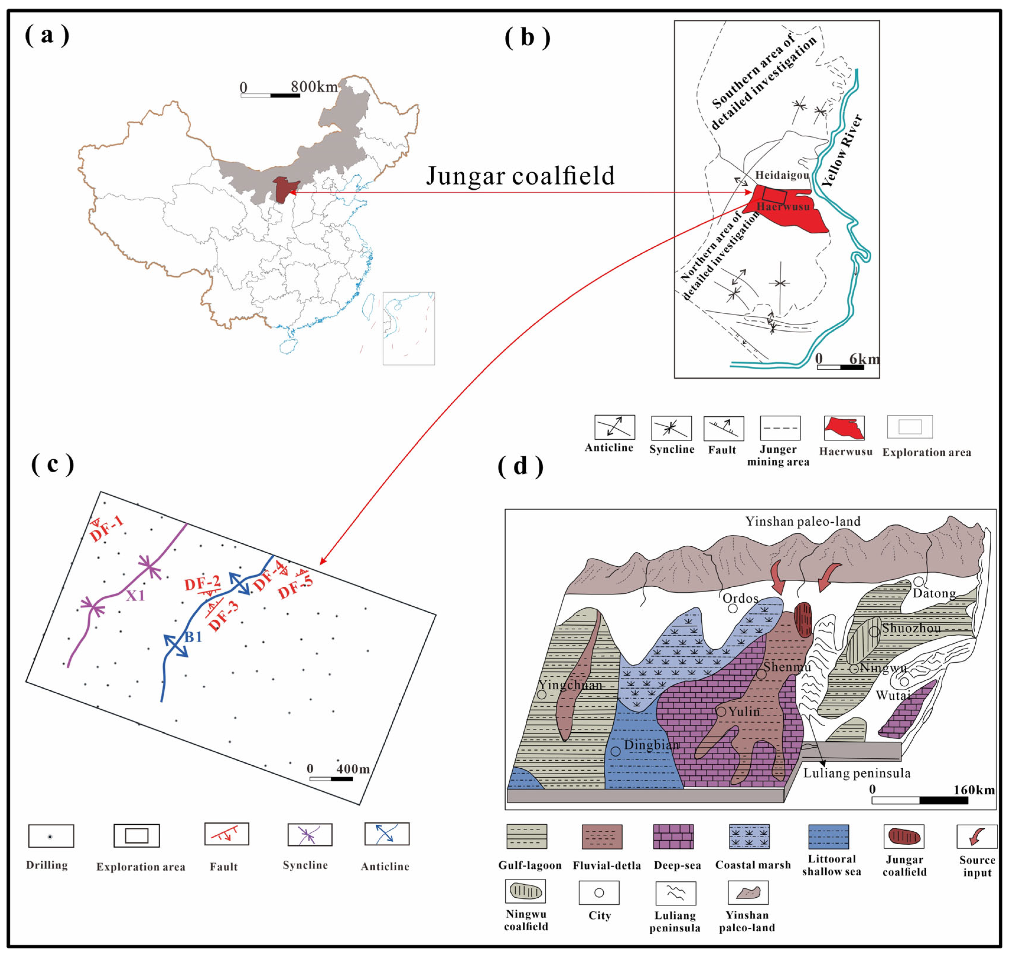
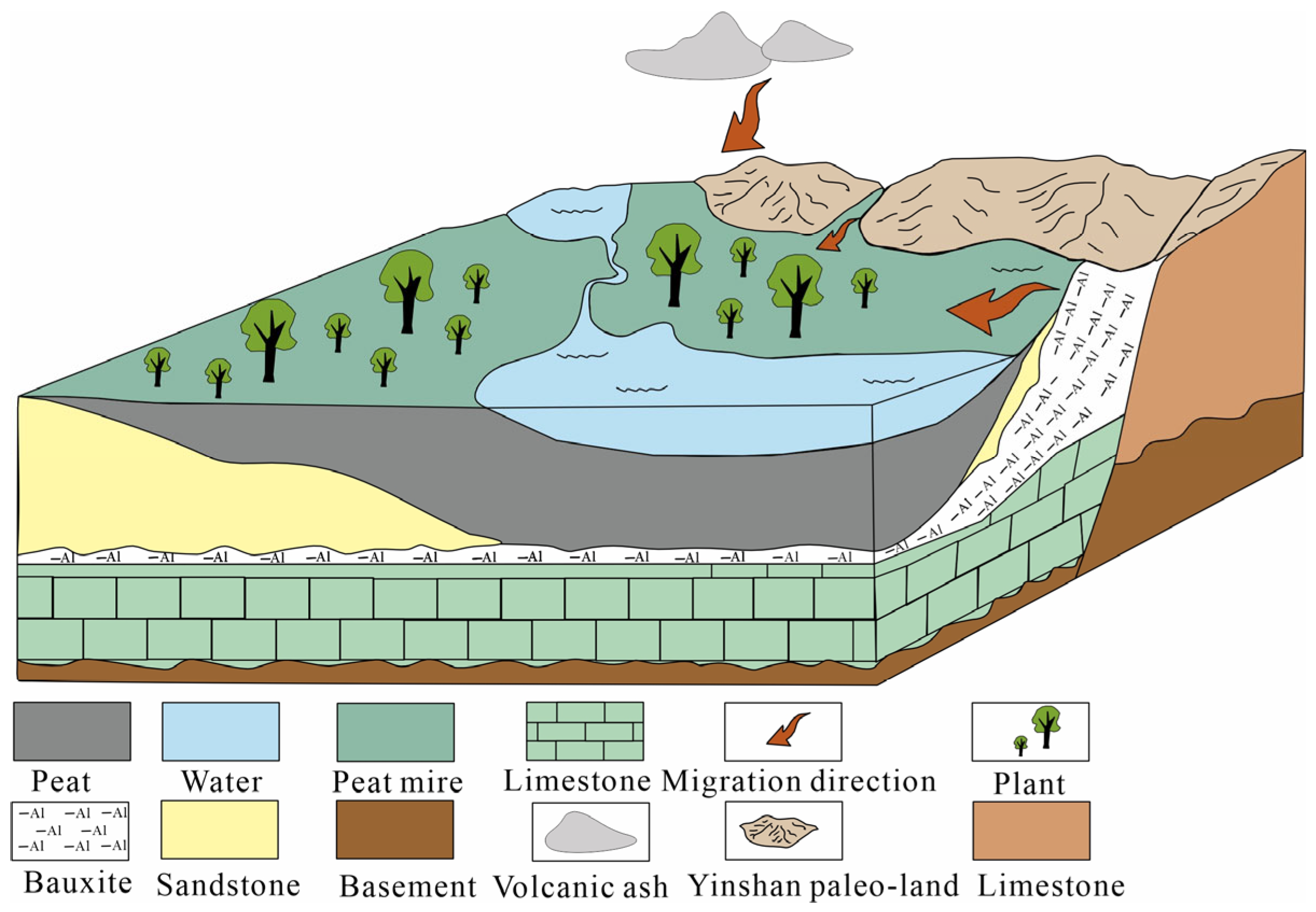
2.1. Geological Background

The Jungar coalfield is located in the southwest of the Inner Mongolia Autonomous Region (Figure 1a), on the northeastern edge of the Ordos Basin. The Ordos platform syncline is a very large and extremely wide asymmetrical syncline structure with the axis of the syncline to the west [44]. The internal structure of the platform syncline is simple and fold fractures are rare. The general structural characteristics of the Jungar coalfield are low-dip monoclinic structures with a dip angle of less than 10°, trending from south to north and inclined to the west. The structure outline of the Jungar coalfield resembles an ear shape. In the northern edge of the coalfield, the strata trend turns to east–west and is inclined to the south. In the southern margin of the coalfield, the strata trend is NW and inclined to the SW [45,46,47]. The geological structure inside the coalfield is relatively simple, with wide and slow folds and sparse faults (Figure 1b). The folding structure causes the wavy relief of the coal seam, and faults destroy the continuity of the coal seam. Since the dip angles of the back and syncline are generally not large, and the number of faults is small, the damage to the coal seam is very small.
Haerwusu mine is situated in the middle of the Jungar coalfield, Inner Mongolia Autonomous Region (Figure 1b). The structures developed in the area mainly include straight slopes, anticlines, and normal faults (Figure 1c). In the exploration area, the monoclinal structure is the main body, and the change in strike and inclination of the coal seam is dominated by slow wave relief. No significant fault structures were identified, so the exploration area falls under the simple structure type. The coal-bearing strata in this area are the Shanxi Formation of the Lower Permian Series (P1s) and the Taiyuan Formation of the Upper Carboniferous Series (C3t), which are a set of terrigenous clastic coal-bearing deposits with calcareous rocks, with a total thickness of about 110–160 m, and its paleogeographic environment belongs to the offshore inland basin type. No. 5 and No. 6 coal are recoverable coal seams in the Haerwusu mining area. The weathered denudation of potassium feldspar granite in the Yinshan ancient land in the north of the coalfield provides the main source of Li enrichment in the Jungar coalfield. The further weathering and denudation of bauxite in the Benxi Formation caused by the Luliang Paleo uplift in tectonic movement also provided the source for the Jungar coalfield, and its paleogeographic environment belongs to the offshore inland basin type (Figure 1d).

2.2. Analytical Methods

The original exploration borehole data and test data were analyzed [48]. The geological background and drilling data of the study area were comprehensively analyzed, and the contour map of coal seam thickness and Li content were drawn using mapping software MAPGIS 6.3. Based on the distribution characteristics of Li content, the exploration techniques were reviewed and optimized according to the relevant standards such as the specifications for coal exploration [49] and the specifications for rare metal mineral exploration [50]. Finally, the collaborative exploration model of coal–Li deposits was determined.

3. Coal–Li Deposit Distribution Characteristics
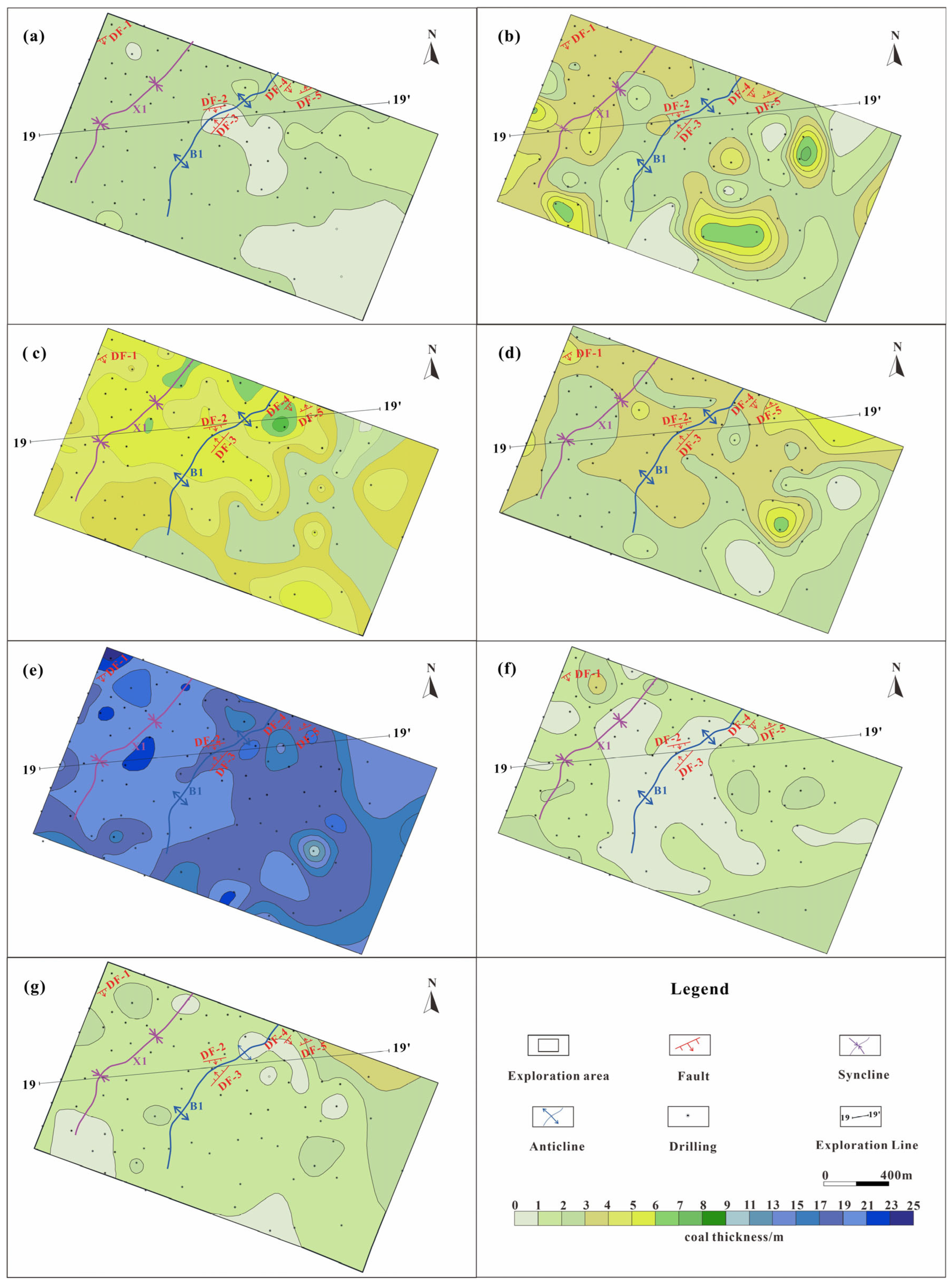
3.1. Coal Seams

The Jungar coalfield is a significant component of the Carboniferous Permian coalfield, and the coal-bearing strata of the Haerwusu open pit are the Shanxi Formation of Lower Permian Series and the Taiyuan Formation of Upper Carboniferous Series. The coals are classified as low-metamorphic bituminous and long-flame coal, with a total of eight coal layers. There are only No. 5 and No. 6 coal seams in this area, of which the No. 5 coal seam is the most recoverable coal seam and the No. 6 coal seam occupies the whole area of the coal seam. The No. 6 coal seam is divided into No. 6-1, No. 6-2, No. 6-3, No. 6-4, No. 6-5, and No. 6-6 coal according to the characteristics and structure of the coal parameter.
The thickness of the isolines of the Haerwusu coal is shown in Figure 2. No. 5 coal is mostly recoverable in the whole area, the maximum thickness is 2.88 m with an average of 1.58 m, and it is situated in the middle and lower part of the Shanxi Formation. The distance between the No. 6 composite coal seam varies greatly, ranging from 7.61 to 28.58 m with an average of 14.03 m. Only in the southeast corner of the exploration area does thinning and gradual peaking appear. No. 6 coal is a composite coal seam in this area, with a thickness of 25.53–39.32 m and an average thickness of 33.70 m; it can be mined in the whole area with a very large thickness and complex structure. No. 6-1 coal is located at the top of the No. 6 composite coal seam, and the upper distance from the No. 5 coal seam is 7.61–2.58 m, with an average distance of 14.03 m. The thickness tends to be thicker from northwest to southeast, and it belongs to the stable coal seam that can be mined in most of the area. No. 6-2 coal is a high-ash coal, the thickness of the coal seam is 0.77–7.55 m, and the variation in thickness shows that it is thicker in the middle of the survey area and thinner in the surrounding area. The thickness of No. 6-3 coal is 0.40–6.37 m with an average thickness of 3.05 m, the thickness changes little, and it belongs to the stable coal seam that can be mined in the whole area. The upper distance of No. 6-4 coal from the No. 6-3 coal seam is 1.10 m, with an average of 0.27 m; the thickness of the coal seam is 9.98–23.29 m, with an average of 18.18 m; and the variation in thickness increases from southeast to northwest. The maximum thickness of No. 6-5 coal is 5.22 m with an average of 1.52 m, the thickness of the thicker coal seam in the middle varies greatly, and the coal quality is different. The thickness of No. 6-6 coal varies greatly; the maximum thickness of the coal seam is 3.40 m, with an average of 1.52 m, and the thickness changes gradually from south to north.

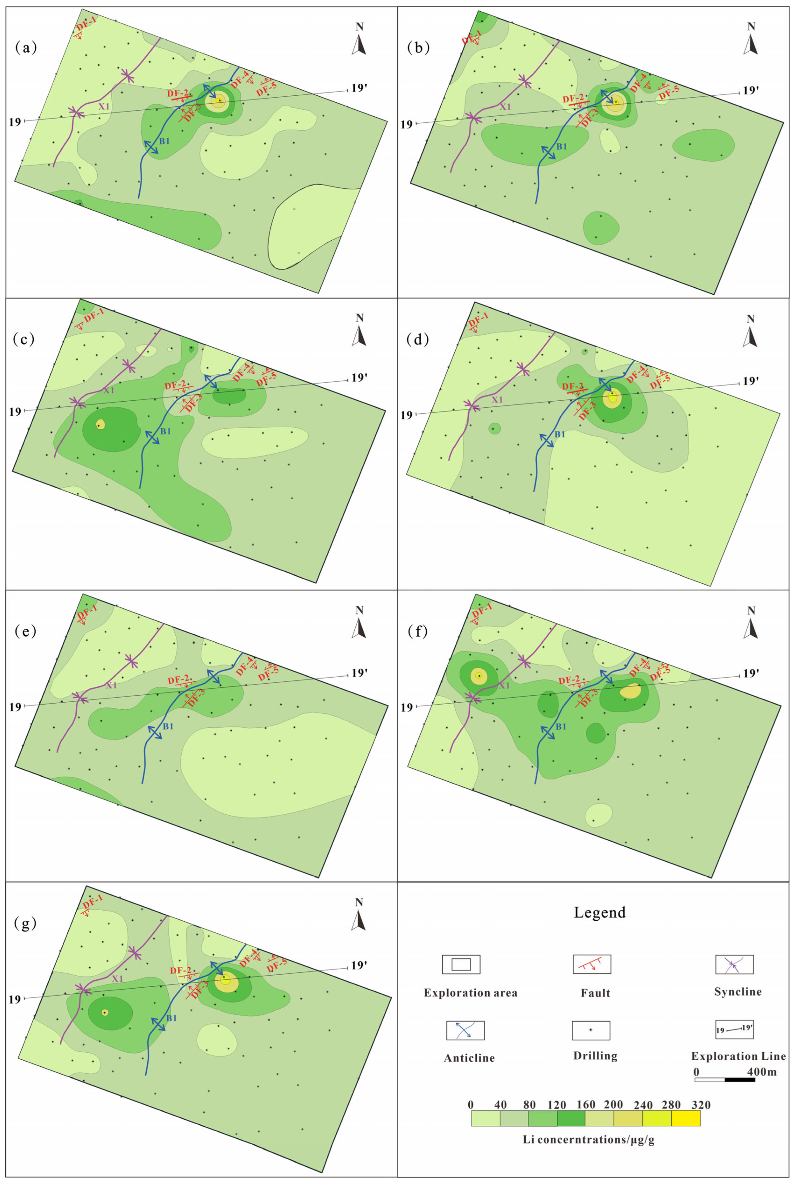
3.2. Surface of Li Deposit

The distribution characteristics of Li deposits in No. 5 and No. 6 coal are similar. The high-Li area (Li ≥ 50 μg/g) is distributed near the B1 anticline or in the central area between the X1 syncline and the B1 anticline (Figure 3). Because the Li content was not tested in the previous borehole used in the original exploration, the Li distribution characteristics of the eastern and southern regions could not fully reflect the distribution of Li deposits in the exploration area.
The Li content of No. 5 coal is 0–270 μg/g (average 59 μg/g), which is mainly distributed near the B1 anticline in the middle, the northwest, and southwest margin, showing a spindle shape characteristic of northeast–southwest in the middle. The Li content of No. 6-1 coal is 16–300 μg/g (average 60 μg/g), which is mainly distributed between the X1 syncline and B1 anticline, and there is a small distribution in the corners and edges of the survey area. The Li content of No. 6-2 coal is 8–162 μg/g (average 66 μg/g), its distribution range is large, and the high-Li-value area is located between the X1 syncline and B1 anticline and the east side of the B1 anticline, across the whole exploration area. The Li content of No. 6-3 coal is 0–207 μg/g (average 55 μg/g), and its distribution position is similar to that of No. 6-2 coal, but the range of the high-Li-value area is slightly reduced. The Li content of No. 6-4 coal is 0–135 μg/g (average 56 μg/g), which is mainly distributed in the vicinity of the B1 anticline, in the northwest and southwest margin, and the spindle shape characteristic of northeastern–southwest orientation is displayed. The Li content of No. 6-5 coal is 0–204 μg/g (average 75 μg/g), which is mainly distributed in the vicinity of the X1 syncline and B1 anticline as well as in the northwest corner, and the high-value area of Li shows an ellipse towards the southeast and northwest. The Li content of No. 6-6 coal is 0–237 μg/g (average 64 μg/g), which is mainly distributed in the vicinity of the X1 syncline and B1 anticline; the two concentrated areas of Li content are distributed in the east side of the X1 syncline and B1 anticline; and the high-value area of Li shows the characteristics of east–west orientation.

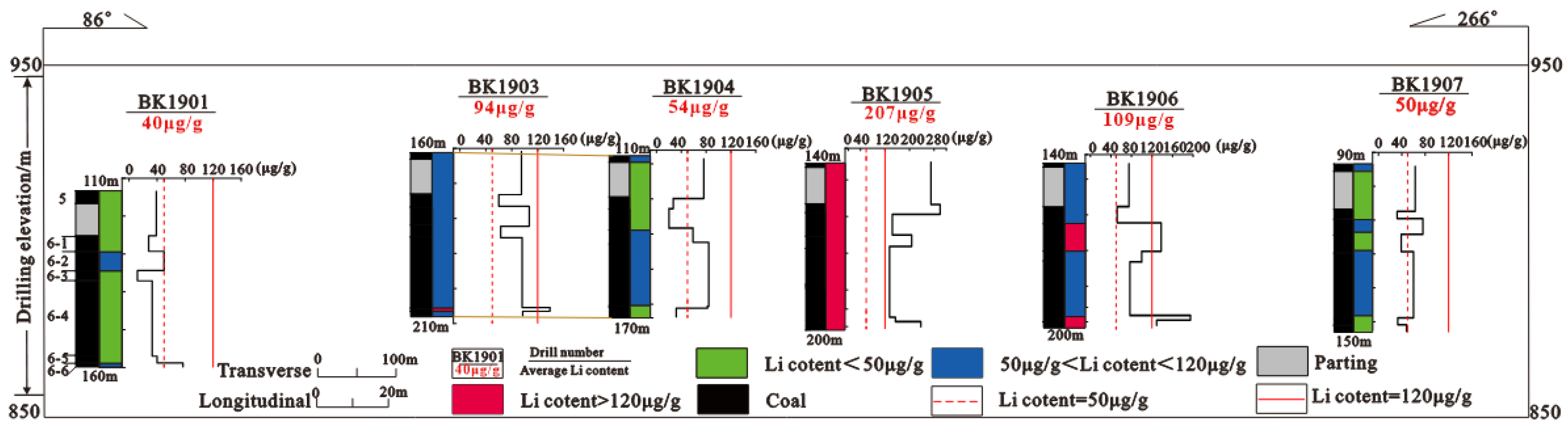
3.3. Vertical of Li Deposit

The structure of the No. 5 coal and No. 6 composite coal seams are simple, and the coal rock and coal quality of the other coal seams have little change except for No. 6-2 coal; it is a high-ash coal and contains a thin parting. Only 32 boreholes in the exploration area were tested for Li content. Through statistical analysis of the vertical distribution of 32 boreholes, it was found that the vertical distribution of Li content was irregular, and the difference in Li content in adjacent boreholes was large, so the vertical distribution of Li content was not obvious. Taking exploration line 19 as an example (Figure 4), the weighted average Li content in adjacent boreholes is highly variable, with the average Li content in BK1904 being 54 μg/g and that in adjacent borehole BK1905 being 207 μg/g.

4. Occurrence State and Origin of Enrichment of Li in Coal

The occurrence state of Li in coal is shown in Table 1. The Li in coal is mainly related to the clay minerals, and the rest of the Li is combined with organic matter, or exists in mica and tourmaline [14,19,20,51,52,53]. Li mainly occurs in kaolinite, Boehmite, and chlorite in the Jungar coalfield in China [14,19]. In view of this research area, Dai et al. conducted research on Haerwusu coal in the Jungar coalfield and found that Li in coal mainly occurs in aluminosilicate minerals [14].
The enrichment of trace elements in coal is typically influenced by provenance, sedimentary environment, volcanic activity, post-sedimentary hydrothermal alteration, groundwater activity, and other geological and geochemical factors [3,16,57]. Predecessors have summarized the research results on Li in the Jungar coalfield and indicated that the enrichment of Li in coal-bearing rock is controlled by terrigenous clastic material supply, redox conditions, fluid activity, and complex water/rock interaction processes [14,19,55]. The study area is located on the edge of the North China Platform. After the Devonian Period, before the Permo-Carboniferous transgression was deposited, the Jungar coalfield and its surrounding areas were in a hot and humid climate with intense chemical weathering. Due to the stable structural conditions, it was conducive to the formation of bauxite, and the moyite clastic materials of the Yinshan ancient land provided direct provenance for the study area [14,19]. Bauxite residue within the weathering crust was a source of Li, and the input of volcanic ash produced by volcanic activities affects the enrichment characteristics of Li [55,58,59,60,61]. During the formation of Haerwusu Li-rich coal, the chemically altered detrital material of moyite from the Yinshan ancient land was initially enriched in the weathering crust of the Upper Carboniferous Benxi Formation after long-term surface efflorescence, denudation, and transport. The bauxite regolith of the Benxi Formation was exposed to the surface by tectonic movement and further subjected to weathering denudation. The bauxite residuals of the Benxi Formation were deposited in the coal-bearing basin along with surface runoff transport, while volcanic ash produced by continental arc volcanism in the late Paleozoic era was enriched in coal by the leaching and redistribution of groundwater, and existed in clay minerals by isomorphism [14,19,55,58] (Figure 5).

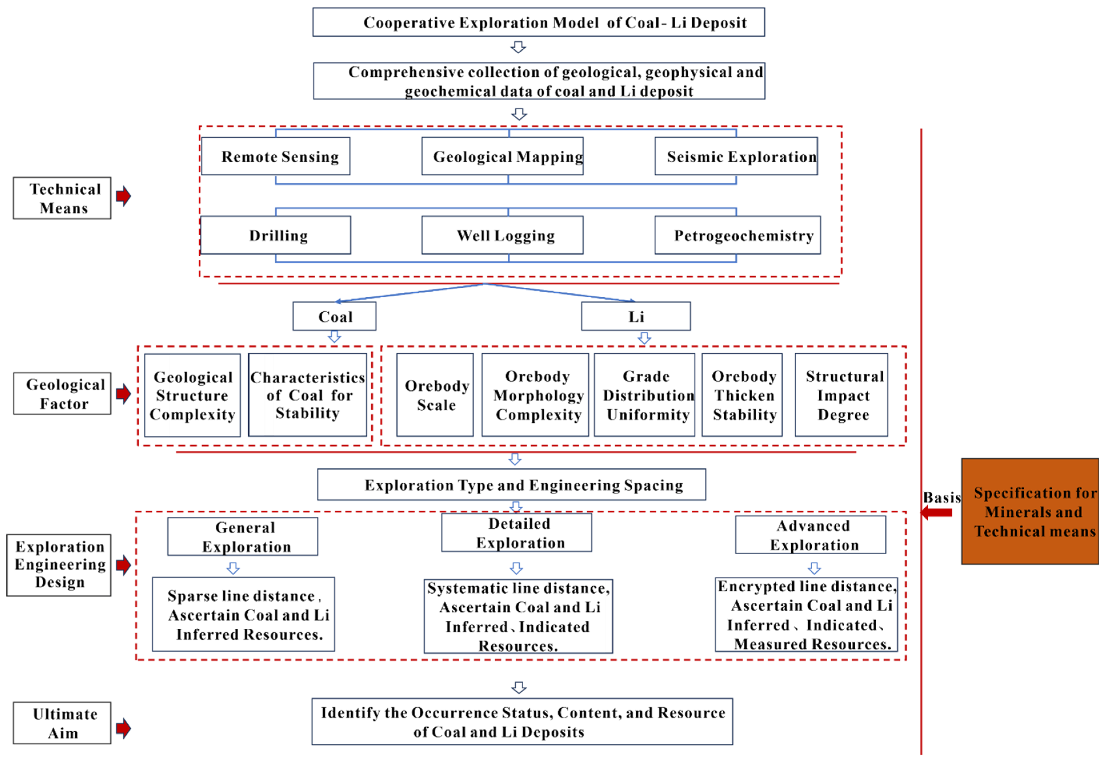
5. Cooperative Exploration Model of Coal–Li Deposits

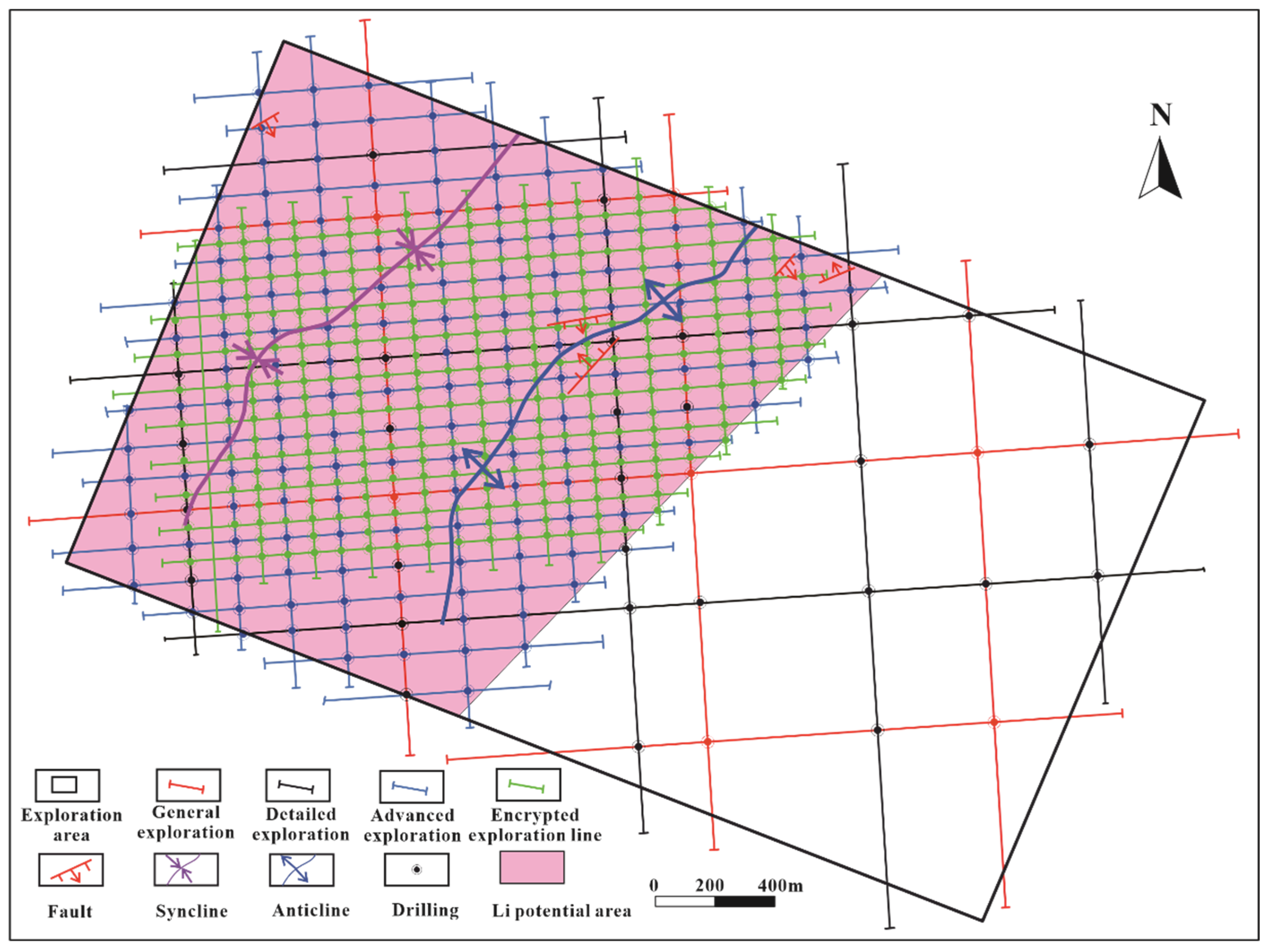
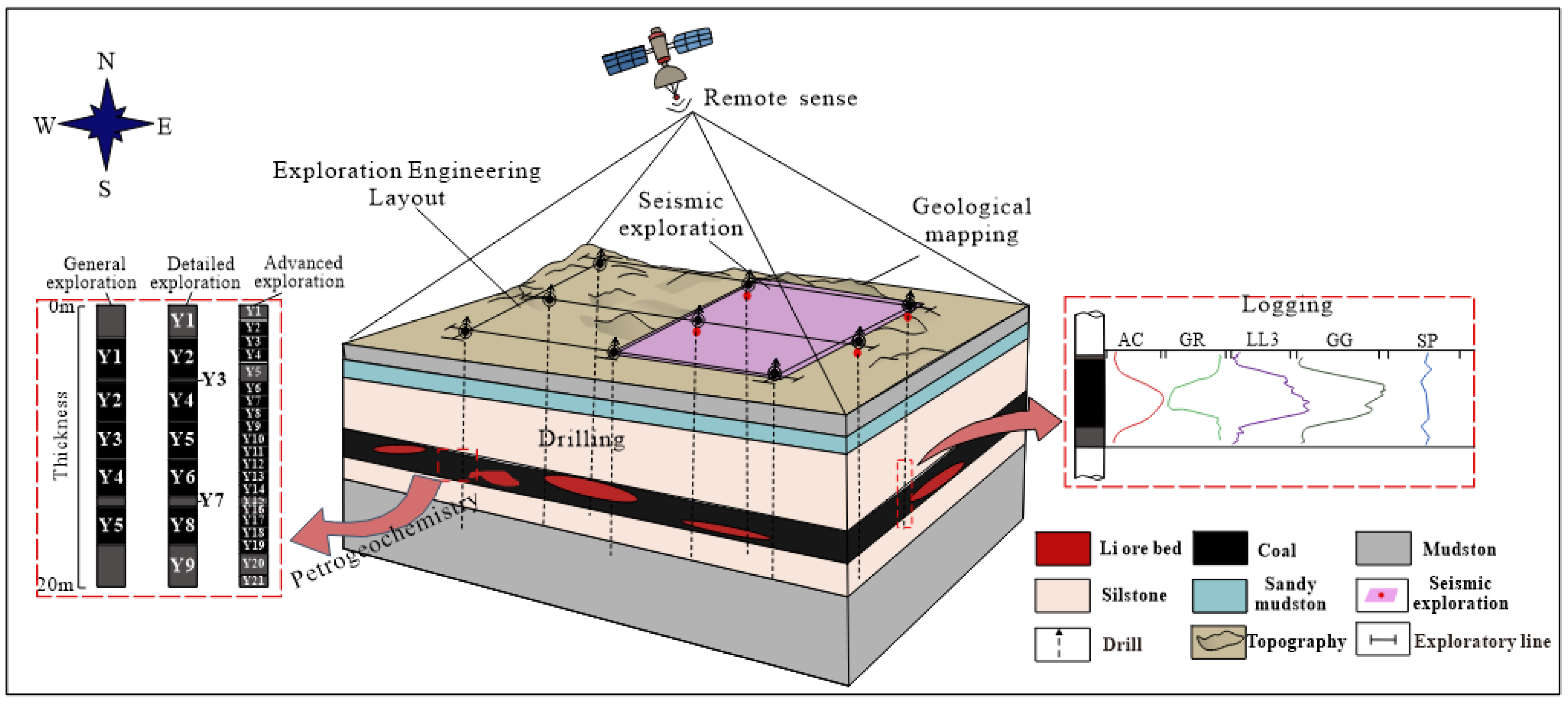
5.1. Original Exploration Techniques, Exploration Engineering Design, and Resource Estimation

The original exploration techniques were based on 3D seismic exploration and drilling, combined with a topographic and geological map survey, geophysical logging, and petrogeochemistry, to determine the occurrence, content, and resources of coal and Li deposits [48].
The design of the original exploration drilling was mainly based on the exploration line section method of vertical strata strikes, and the main exploration line was basically parallel to the advanced exploration [48]. The line distance was 250–300 m, the exploration network of 250 m × 250 m was basically formed, and the inferred resource was delineated for No. 5 coal and the indicated resource amount for No. 6 composite coal.
In the original exploration, the Li resources were not estimated, and the determination principle of Li grade was not proposed [48]. The geological block method was used to calculate coal seam resources, but the Li resources were not estimated. The inferred resource amount was determined by a 250 m × 250 m grid degree for No. 5 coal, the indicated resource amount was determined by a 250 m × 250 m grid degree for the No. 6 composite coal seam [62], and the inferred resource amounts of No. 5 coal and No. 6 coal were extrapolated 30 m from the intersection line between the fault and coal on both sides of the fault.

5.2. A Review of the Original Exploration Techniques, Exploration Engineering Design, and Resource Estimation

The exploration area is characterized by limited bedrock exposure and complex topographic conditions. The original aerial survey produced a 1:2000-scale topographic map with contour intervals of 2 m, which adequately met the exploration requirements for the area. In order to identify the potential structures and collapse columns in the exploration area, a rectangular region measuring 2.54 km in length and 0.86 km in width was selected for 3D seismic exploration. The composite reflection wave T6 formed by the No. 6 coal seam is the standard reflection wave for interpreting the structure and coal seam in this area. In the original exploration, the thickness distribution of the fault, syncline, anticline, and main coal seam in the exploration area was better identified by using 3D seismic exploration. The deep seismic geological conditions in the exploration area were better, and 3D seismic exploration can be better completed. Because the coal seam buried depth is 146–337 m, the drilling engineering carried out strata disclosure, ore layer control, sample collection, and resource delineation; therefore, drilling engineering is the exploration technology that must be selected in the exploration. The sampling principle of the original exploration coal sample was one coal sample from No. 5 coal. In No. 6 composite coal, two coal samples were taken from No. 6-4, and one coal sample was taken from the other layers. The sampling principle of the coal seam parting and the top and floor sample was to collect one dirt collection sample from coal No. 5 of all boreholes and collect one parting sample from each layer of coal in No. 6 of the composite coal seam. One sample was taken for each coal stratification, and one sample was taken for the top and bottom of No. 5 coal and No. 6 composite coal. Each coal sample was tested for Li content, but only a small number of samples were tested for Li content. The techniques of petrogeochemistry in the original exploration violated the principle of technical efficiency and gradual progress. The main coal seams in the exploration area have obvious physical property differences from sandy mudstone, mudstone, and siltstone. Conventional parameters in coal logging were used in the original exploration, which was used to classify lithology and the coal seam. The combination of logging technology selected in the original exploration can better distinguish the boundary between coal seam, roof, floor, and gangue, so the selection of logging technical parameters is reasonable.
For the review of coal exploration engineering design, the original exploration engineering design was based on the specifications for coal exploration, which determined that the structural complexity of the exploration area was of the simple type and the main recoverable No. 6 coal seam was of the stable type. The class was divided by the complexity of structure, and the type was divided by the stability of the coal seam, so it was determined that the coal exploration type was class 1 and type 2. The original exploration line distance was generally 250–300 m, basically formed by a grid of 250 m × 250 m, controlled the amount of proved resources, and met the requirements of the coal geological exploration standard line distance. The original exploration engineering design was only for coal, without considering the distribution of Li resources, and the corresponding exploration engineering design for Li was not carried out.
In the original exploration, the No. 5 coal seam was divided into inferred resources, and the resource level classification at the sparsely drilled area or the line distance was greater than 500 m, which was still classified into the same level as the same coal seam, which violated the requirements of the resource level of coal geological exploration standards. It is stipulated in the specifications for coal exploration that when delimiting proved resources and controlling resource blocks across faults, a range of 30 m to 50 m should be divided on both sides of the faults (drop ≥ 30 m) as inferred resource blocks. When the fault is dense, delimiting the proved resources and control resources across the fault is prohibited. In the original exploration, the exploration network degree near the fault was classified as inferred resources, which violated the requirements of the specifications for coal exploration. The original exploration only estimated the reserves of coal resources and did not estimate the Li resources.
In conclusion, the exploration techniques of petrogeochemistry in the original exploration violated the principle of gradual and orderly sample collection and testing, so it needs to be optimized. The original exploration did not carry out a comprehensive analysis of the distribution of Li content, the estimation of coal and Li resources did not conform to the principle of coal resource division, and the Li resources were not calculated.

5.3. Coal–Li Deposit Cooperative Exploration Techniques, Exploration Engineering Design, and Resource Estimation Optimization

5.3.1. Optimization of Cooperative Exploration Techniques

According to the characteristics of the terrain, surface, regional geological background, structure, coal seam, and Li layer of the exploration area, the occurrence state, content, and resource of coal and Li deposits are ascertained by means of topographic geological map surveys, 3D seismic exploration, drilling, logging, petrogeochemistry, and other cooperative exploration techniques [48]. The methods of petrogeochemistry exploration are optimized according to different stages of exploration while adhering to the principles of pertinence, technical efficiency, gradual progress, and economic rationality.
In the general exploration and detailed exploration, one full-layer coal sample is taken when the thickness of the coal seam is less than 3 m. However, when the coal seam exceeds 3 m, one coal sample is taken every 3 m, and during the advanced exploration, one coal sample is taken every 1 m of the coal seam. The sampling method of the top and floor of the coal seam and parting samples in the general exploration involves taking one sample between layers of the No. 5 coal and No. 6 composite coal seam and one sample of the top and floor. In the detailed exploration, when the thickness of the top and floor is less than 3 m, one full-layer sample is taken, and when the thickness exceeds 3 m, one full-layer sample is taken for every 3 m. When the thickness of the dirt is less than 0.1 m, one parting sample is taken. In the advanced exploration, when the thickness of the top and floor is less than 3 m, one full layer sample is taken; when the thickness is more than 3 m, one full-layer sample is taken for every 3 m; when the thickness is less than 0.1 m, one parting sample is taken; and when the thickness is more than 0.1 m, one sample is taken for every 0.1 m.

5.3.2. Optimization of Cooperative Exploration Design

In the cooperative exploration of coal and Li deposits, the characteristics of the uneven and mutational distribution of Li elements are fully considered, and different engineering design schemes are adopted in different blocks in the study area based on the principle of zoning. The exploration engineering design is determined by the occurrence of coal-bearing strata and the distribution of Li content and regional characteristics. A square survey network system is employed for general exploration, while the detailed exploration and advanced exploration represent a rectangular survey network system. The direction of the exploration line is determined by taking into account the trend of coal seams and variations in Li content. The direction of the long side of the rectangular exploration network is northeast (coal seam and Li deposit towards), and the direction of the short side is northwest (coal seam and Li deposit trend). According to the specifications for coal exploration, it is determined that the stability degree of the coal seam in the exploration area is of the stable type, the structural complexity is of the simple type, and the exploration type of coal in the exploration area is class 1 and type 2. The sum of the five geological parameter types of the Li layer is determined to be 3.0 according to the specification for rare metal mineral exploration, so the Li exploration type is type I.
After comprehensive consideration of the exploration types of coal and Li deposits, a cooperative exploration engineering design for the coal–Li deposit was determined. In the general exploration, the square exploration network system (1000 m × 1000 m) was used to understand the coal seam and Li situation, and the high-Li area was divided. The detailed exploration and advanced exploration adopted a rectangular survey network system, the net degree of coal-indicated resources was determined to be 800 m × 500 m, and the net degree of coal-measured resources was 400 m × 250 m. The net degree of Li-indicated resources was determined to be 200 m × 125 m, and the net degree of Li-measured Li resources was 100 m × 60 m. This was limited by the data from the original survey, some boreholes were not tested for Li content, and there were few vertical test data points. This optimization divided the X1 syncline, B1 anticline, and western region into Li resource potential areas, and cooperative exploration engineering design optimization was carried out in this area (Figure 6).

5.3.3. Optimize Resource Estimation

The estimation of Li resources was not included in the original survey, so this optimization was calculated by referring to the minimum utilization content of Li in coal (50 μg/g) stipulated in the guidance for the utilization and classification of content of valuable elements in coal. On the surface, the Li = 50 μg/g contour line was used as the estimation boundary to estimate Li resources. Vertically, two coal samples were taken from the 6-4 coal seam for testing Li content, while one coal sample was taken from other coal seams, so this represents the whole layer grade to calculate and determine potential resources. However, since the existing data only took and tested the Li content of one coal sample for each coal seam, this optimization did not distinguish the orebody in the vertical direction.
The geological block method was employed to estimate the coal and Li resources in this study. The coal exploration type in the exploration area was class 1 and type 2, and the Li deposit exploration type was type I. The type of resources was determined according to specifications for coal exploration and the specification for rare metal mineral exploration. The coal-measured resources were determined by a grid degree of 250 m × 250 m, and the blocks that were not proved were determined as the indicated resources. The Li resources were bound by Li = 50 μg/g, and the potential resources were delineated by making full use of boreholes in the area.
In cooperative exploration techniques, Li content determination generally increased after optimization. The potential areas of Li resources in exploration engineering design were divided based on the distribution characteristics of Li content, the exploration engineering design of coal and Li deposits was carried out according to the exploration norms, and the coal and Li resources were calculated by the geological block method.

5.4. Coal–Li Deposit Cooperative Exploration Model

Due to the trace and dispersibility characteristics of Li, as well as its co-existence with coal, independent exploration and development of this mineral are challenging. Therefore, implementing the cooperative exploration of Li minerals within coal mine production is an economically reasonable and technically feasible optimal approach. Taking the Haerwusu coal–Li deposit as an example, this study proposes economical and effective exploration techniques, a reasonable exploration engineering design, and resource estimation parameters based on the distribution characteristics of the coal–Li deposit and the effectiveness of the response to exploration techniques. The cooperative exploration model for the coal–Li deposit is determined by incorporating economical and effective techniques along with a rational exploration engineering design (Figure 7).
The preconditions for the cooperative exploration of coal–Li deposits are the enrichment and metallogenic mechanism and the occurrence rule of Li elements. It is based on multi-disciplinary theories of coal geology, geochemistry, geophysics, and exploration engineering, supported by a cooperative exploration technology system composed of key technologies such as precision drilling, fine geophysical exploration, and fine geochemical exploration, on the basis of the general requirements for mineral exploration; the specifications for comprehensive appraisal, prospecting, and exploration; the evaluation of mineral resources; and the specifications for coal exploration and other individual mineral exploration standards. In accordance with the general principles of solid mineral resource exploration, comprehensive exploration, and individual mineral exploration, as well as the principles of research first, effective technology, detailed exploration, dynamic adjustment, regional policies, coordination, and synchronization coordinate the organization of exploration engineering and the implementation of key technologies. On the basis of the above, the balance of the best technical benefit and the best economic benefit of the cooperative exploration of coal and Li deposits is realized, and the geological basis is provided for the comprehensive development and utilization of coal measure mineral resources.
The flow chart of the coal–Li deposit cooperative exploration model is shown in Figure 8. Adhering to the principle of research first, the terrain, surface, regional geological background, structure, coal seam, and Li deposit were comprehensively analyzed. Through the interpretation of remote sensing images, the main geomorphic morphology, lithologic combination types, and coal seam distribution were determined. Different scales of geological exploration have different requirements for geological mapping, through which the stratigraphic sequence, geological characteristics of coal-bearing strata, geological structure forms, coal seam characteristics, associated minerals, and other information can be preliminarily identified in the exploration area. The drillings are utilized to expose the ore-bearing layer of Li minerals, and the depth of the drilling design is 15–20 m below the mineral layer. During coal geological exploration, comprehensive logging is necessary for all boreholes. Conventional coalfield logging must measure resistivity, natural gamma radiation, density, spontaneous potential or sound waves, caliper, well deflection, and other logging parameters. The selection of logging parameters primarily aims to classify lithology, distinguish the coal seam, and qualitatively determine the thickness of the coal seam. Seismic exploration is mainly used to infer the nature and form of underground rock, the main seismic survey line spacing survey stage is generally 1000–2000 m, the detailed investigation stage is generally 500–1000 m, and the exploration stage is generally 250–500 m. Petrogeochemistry is an important basis for the correct evaluation of mineral resources. Since Li in coal predominantly occurs in clay minerals, mica, tourmaline, and other minerals, it is necessary to pay attention to the testing and analysis of minerals in coal during the geochemical analysis of Li rocks and analyze the occurrence state of Li in coal by means of scanning electron microscopy, X-ray diffraction, electron microprobe analysis, and other testing methods. The content, occurrence state, and amount of coal and Li resources were studied.
In accordance with the geological exploration standards, the exploration type of coal–Li deposits and the reasonable cooperative exploration engineering design are determined. The three stages of general exploration, detailed exploration, and advanced exploration follow the principle of gradual progress, distributing the exploration engineering design plan to mitigate the investment risk of cooperative exploration and the development of coal–Li deposits, achieve reasonable economic benefits, and finally identify the occurrence state, content, and amount of coal and Li deposit resources. This provides important theoretical guidance for the comprehensive development and utilization of coal and Li resources.
The cost of cooperative exploration of coal–Li deposits is higher than that of coal exploration. The cooperative exploration of coal–Li deposits requires the addition of petrogeochemistry (testing and analyzing Li content in coal) and infill drilling on the basis of coal exploration. Following the progressive sampling principle of general exploration-detailed exploration-advanced exploration, the number of samples tested varies. Consequently, the main increased test cost was the determination of Li content. The design of the infill drilling was determined according to the content of Li in coal. When the content of Li in coal reached industrial grade, the engineering quantity was increased by referring to the Specification for Rare Metal Mineral Exploration of single mineral species [50]. If the industrial grade was not reached but the evaluation reference index was reached, the engineering quantity was appropriately increased. If the evaluation reference index was not reached, the increase in engineering quantity was not considered. So, the increased drilling and logging costs were determined based on the increased number of boreholes.

6. Conclusions

(1)
The high-Li region (Li ≥ 50 μg/g) in the surface is distributed near the B1 anticline or in the central region between the X1 syncline and the B1 anticline. The vertical distribution of Li content is irregular, and the difference in Li content in adjacent boreholes is significant.
(2)
Based on the distribution characteristics of the Haerwusu coal–Li deposit and the effectiveness of exploration techniques, a comprehensive review and optimization were conducted for exploration techniques, engineering design, and resource estimation. The economical and effective exploration technology, reasonable exploration engineering design, and resource estimation parameters for coal–Li deposit cooperative exploration were proposed to establish a cooperative exploration model.
(3)
The cooperative exploration model of the coal–Li deposit encompasses economical and effective techniques and reasonable exploration engineering design. The exploration engineering was jointly organized and key technologies were implemented to achieve balance between the best technical benefits and economic benefits of the cooperative exploration of coal and Li deposits.

Author Contributions

Data curation, X.L. (Xin Li); formal analysis, X.L. (Xin Li), Y.W. and J.W.; methodology, Y.W. and D.C.; resources, Y.W., D.C. and X.L. (Xiangyang Liu); supervision, Y.W. and D.C. writing—original draft, X.L. (Xin Li), Y.W., J.W., Y.Z. and B.D. All authors have read and agreed to the published version of the manuscript.

Funding

This research was funded by the National Key Research and Development Plan of China, (2021YFC2902004), National Natural Science Foundation of China (grant No. 42372187, 41972174), and the Fundamental Research Funds for the Central Universities (grant No. 2023ZKPYDC03), and the Special Project for Geological development of Ningxia in 2023 (640000233000000011005).

Data Availability Statement

Data are contained within the article.

Conflicts of Interest

Xiangyang Liu are employees of Shenhua Geological Exploration Corporation Limited. The paper reflects the views of the scientists and not the company.

References

  1. Kim, N.; Su, X.; Kim, C. Electrochemical lithium recovery system through the simultaneous lithium enrichment via sustainable redox reaction. Chem. Eng. J. 2021, 420, 127715. [Google Scholar] [CrossRef]
  2. Zhao, L.; Wang, X.; Dai, S. Lithium resources in coal-bearing strata: Occurrence, mineralization, and resource potential. J. China Coal Soc. 2022, 47, 1750–1760. (In Chinese) [Google Scholar]
  3. Seredin, V.; Dai, S.; Sun, Y.; Chekryzhov, I. Coal deposits as promising sources of rare metals for alternative power and energy-efficient technologies. Appl. Geochem. 2013, 31, 1–11. [Google Scholar] [CrossRef]
  4. Sun, B.; Zeng, F.; Moore, T.; Rodrigues, S.; Liu, C.; Wang, G. Geochemistry of two high-lithium content coal seams, Shanxi Province, China. Int. J. Coal Geol. 2022, 260, 104059. [Google Scholar] [CrossRef]
  5. Wei, Y.; He, W.; Qin, G.; Fan, M.; Cao, D. Lithium enrichment in the No. 21 coal of the Hebei No. 6 mine, Anhe coalfield, Henan Province, China. Minerals 2020, 10, 521. [Google Scholar] [CrossRef]
  6. Qin, G.; Cao, D.; Wei, Y.; Liu, B.; Querol, X.; Font, O.; Moreno, N.; Li, J.; Gang, T.; Liang, G. Geochemical characteristics of the Permian coals in the Junger-Hebaopian mining district, northeastern Ordos Basin, China: Key role of paleopeatforming environments in Ga-Li-REY enrichment. J. Geochem. Explor. 2020, 213, 106494. [Google Scholar] [CrossRef]
  7. Dai, S.; Yan, X.; Ward, C.R.; Hower, J.C.; Zhao, L.; Wang, X.; Zhao, L.; Ren, D.; Finkelman, R.B. Valuable elements in Chinese coals: A review. Int. Geol. Rev. 2016, 60, 590–620. [Google Scholar] [CrossRef]
  8. Coffey, D.M.; Munk, L.A.; Ibarra, D.E.; Butler, K.L.; Boutt, D.F.; Jenckes, J. Lithium storage and release from lacustrine sediments: Implications for lithium enrichment and sustainability in continental brines. Geochem. Geophys. Geosyst. 2021, 22, e2021GC009916. [Google Scholar] [CrossRef]
  9. Chu, G.; Xiao, L.; Jin, Z.; Lin, M.; Blokhin, M. The relationship between trace element concentrations and coal-forming environments in the No. 6 coal seam, Haerwusu Mine, China. Energy Explor. Exploit. 2015, 33, 91–104. [Google Scholar] [CrossRef]
  10. Ning, S.; Huang, S.; Zhu, S.; Zhang, W.; Deng, X.; Li, C.; Qiao, J.; Chen, L.; Zhang, N. Mineralization zoning of coal-metal deposits in China. Chin. Sci. Bull. 2019, 64, 2501–2513. (In Chinese) [Google Scholar]
  11. Sanjuan, B.; Gourcerol, B.; Millot, R.; Rettenmaier, D.; Jeandel, E.; Rombaut, A. Lithium-rich geothermal brines in Europe: An up-date about geochemical characteristics and implications for potential Li resources. Geothermics 2022, 101, 102385. [Google Scholar] [CrossRef]
  12. Yan, X.; Dai, S.; Graham, I.T.; French, D.; Hower, J.C. Mineralogy and geochemistry of the Palaeogene low-rank coal from the Baise Coalfield, Guangxi Province, China. Int. J. Coal Geol. 2019, 214, 103282. [Google Scholar] [CrossRef]
  13. Arora, S.; Gosu, V.; Subbaramaiah, V.; Hameed, B.H. Lithium loaded coal fly ash as sustainable and effective catalyst for the synthesis of glycerol carbonate from glycerol. J. Environ. Chem. Eng. 2021, 9, 105999. [Google Scholar] [CrossRef]
  14. Dai, S.; Li, D.; Chou, C.L.; Zhao, L.; Zhang, Y.; Ren, D.; Ma, Y.; Sun, Y. Mineralogy and geochemistry of boehmite-rich coals: New insights from the Haerwusu Surface Mine, Jungar Coalfield, Inner Mongolia, China. Int. J. Coal Geol. 2008, 74, 185–202. [Google Scholar] [CrossRef]
  15. Sun, Y.; Li, Y.; Zhao, C. Concentrations of lithium in Chinese coal. Energy Explor. Exploit. 2010, 28, 97–104. [Google Scholar] [CrossRef]
  16. Dai, S.; Finkelman, R.B.; French, D.; Hower, J.C.; Graham, I.T.; Zhao, F. Modes of occurrence of elements in coal: A critical evaluation. Earth-Sci. Rev. 2021, 222, 103815. [Google Scholar] [CrossRef]
  17. He, H.; Wang, J.; Xing, L.; Zhao, S.; He, M.; Zhao, C.; Sun, Y. Enrichment mechanisms of lithium in the No. 6 coal seam from the Guanbanwusu Mine, Inner Mongolia, China: Explanations based on Li isotope values and density functional theory calculations. J. Geochem. Explor. 2020, 213, 106510. [Google Scholar] [CrossRef]
  18. Sun, Y.; Zhao, C.; Li, Y.; Wang, J.; Liu, S. Li distribution and mode of occurrences in Li-bearing coal seam# 6 from the Guanbanwusu Mine, Inner Mongolia, Northern China. Energy Explor. Exploit. 2012, 30, 109–130. [Google Scholar]
  19. Sun, Y.; Zhao, C.; Li, Y.; Wang, J.; Zhang, J.; Jin, Z.; Lin, M.; Kalkreuth, W. Further information of the associated Li deposits in the No. 6 coal seam at Jungar Coalfield, Inner Mongolia, Northern China. Acta Geol. Sin. (Engl. Ed.) 2013, 87, 1097–1108. [Google Scholar]
  20. Finkelman, R.B.; Palmer, C.; Wang, P. Quantification of the modes of occurrence of 42 elements in coal. Int. J. Coal Geol. 2018, 185, 138–160. [Google Scholar] [CrossRef]
  21. Qin, S.; Zhao, C.; Li, Y.; Zhang, Y. Review of coal as a promising source of lithium. Int. J. Oil Gas Coal Technol. 2015, 9, 215–229. [Google Scholar] [CrossRef]
  22. Jiu, B.; Huang, W.; Spiro, B.; Hao, R.; Mu, N.; Wen, L.; Hao, H. Distribution of Li, Ga, Nb, and REEs in coal as determined by LA-ICP-MS imaging: A case study from Jungar coalfield, Ordos Basin, China. Int. J. Coal Geol. 2023, 267, 104184. [Google Scholar] [CrossRef]
  23. Wang, Z.; Jin, Z.; Wang, J. Maceral and Organic Geochemical Characteristics of the No. 6 Coal Seam from the Haerwusu Surface Mine, Inner Mongolia, China. Energy Explor. Exploit. 2023, 41, 01445987231176314. [Google Scholar] [CrossRef]
  24. Li, J.; Zhuang, X.; Yuan, W.; Liu, B.; Querol, X.; Font, O.; Moreno, N.; Li, J.; Gang, T.; Liang, G. Mineral composition and geochemical characteristics of the Li-Ga-rich coals in the Buertaohai-Tianjiashipan mining district, Jungar Coalfield, Inner Mongolia. Int. J. Coal Geol. 2016, 167, 157–175. [Google Scholar] [CrossRef]
  25. Yan, X.; Dai, S.; Graham, I.T.; He, X.; Shan, K.; Liu, X. Determination of Eu concentrations in coal, fly ash and sedimentary rocks using a cation exchange resin and inductively coupled plasma mass spectrometry (ICP-MS). Int. J. Coal Geol. 2018, 191, 152–156. [Google Scholar] [CrossRef]
  26. Liu, L.; Zhang, T.; Liu, J.; Liu, Q.; Li, K.; Liu, D.; Liu, W. Genesis of Kaolinite Deposits in the Jungar Coalfield, NorthChina: Petrological, Mineralogical and Geochemical Evidence. Acta Geol. Sin. (Engl. Ed.) 2021, 95, 517–530. [Google Scholar] [CrossRef]
  27. Yudovich, Y.E.; Ketris, M.P. Valuable Trace Elements in Coal; RAS: Ekaterinburg, Russia, 2006. [Google Scholar]
  28. Sun, Y.Z.; Zhao, C.L.; Li, Y.H.; Wang, J.X. Minimum mining grade of the selected trace elements in Chinese coal. J. China Coal Soc. 2014, 39, 744–748. (In Chinese) [Google Scholar]
  29. GB/T 41042-2021; Guidance for Utilization and Classification of Concentration of Valuable Elements in Coal. Standards Press of China: Beijing, China, 2021. (In Chinese)
  30. Rezaei, H.; Shafaei, S.Z.; Abdollahi, H.; Shahidi, A.; Ghassa, S. A sustainable method for germanium, vanadium and lithium extraction from coal fly ash: Sodium salts roasting and organic acids leaching. Fuel 2022, 312, 122844. [Google Scholar] [CrossRef]
  31. Li, S.; Bo, P.; Kang, L.; Guo, H.; Gao, W.; Qin, S. Activation pretreatment and leaching process of high-alumina coal fly ash to extract lithium and aluminum. Metals 2020, 10, 893. [Google Scholar] [CrossRef]
  32. Rui, H.; Zhang, L.; Li, L. Solvent extraction of lithium from hydrochloric acid leaching solution of high-alumina coal fly ash. Chem. Phys. Lett. 2021, 771, 138510. [Google Scholar] [CrossRef]
  33. Fang, H.; Zhou, C.; Xu, S.; Shi, J.; Hu, Y.; Liu, G. High-efficiency extraction of aluminum and lithium from coal fly ash using a novel sodium pyrosulfate mechanochemical activation-Sodium persulfate pressure leaching technology. J. Clean. Prod. 2023, 423, 138841. [Google Scholar] [CrossRef]
  34. Qin, S.J.; Xu, F.; Cui, I.L.; Wang, J.X.; Li, S.Y.; Zhao, Z.S.; Xiao, L.; Guo, Y.X.; Zhao, G.L. Geochemistry characteristics and promising utilization of strategically critical trace elements from coal-related resources. Coal Sci. Technol. 2022, 50, 1–38. (In Chinese) [Google Scholar]
  35. Xu, Z.; Wang, X.; Sun, S. Performance of a synthetic resin for lithium adsorption in waste liquid of extracting aluminum from fly-ash. Chin. J. Chem. Eng. 2022, 44, 115–123. [Google Scholar]
  36. Cao, D.; Lin, Z.; Wei, Y.; Li, X.; Zhang, J.; Zheng, Z. Types and models of coal-deposit exploration in China. Energy Explor. Exploit. 2011, 29, 495–515. [Google Scholar] [CrossRef]
  37. Wei, Y.; Li, X.; Cao, D.; Zhang, Y.; Wei, J.; Xu, L. Cooperative exploration methods of coal and strategic metal resources in coal-bearing strata. Coal Sci. Technol. 2023, 51, 27–41. (In Chinese) [Google Scholar]
  38. Cao, D.Y.; Wei, Y.C.; Li, X.; Zhang, Y.; Xu, L.X.; Wei, J.H.; Dong, B. Discussion on the theory and technical system framework of cooperative exploration of coal andstrategic metal resources in coal-bearing strata. J. China Coal Soc. 2024, 49, 1–16. (In Chinese) [Google Scholar]
  39. Zhang, Y.; Wei, Y.; Cao, D.; Li, X.; Wei, J.; Xu, L.; Dong, B.; Xu, T. Cooperative Exploration Model of Coal–Gallium Deposit: A Case Study of the Heidaigou Coal–Gallium Deposit in the Jungar Coalfield, Inner Mongolia, China. Minerals 2024, 14, 156. [Google Scholar] [CrossRef]
  40. Yang, W.; Wang, Y.; Wang, C.; Sun, X. Distribution and co-exploration of multiple energy minerals in Ordos basin. Acta Geol. Sin. 2010, 84, 579–586. (In Chinese) [Google Scholar]
  41. Wang, Y.; Yang, W.; Deng, J.; Wu, B.; Li, Z.; Wang, M. Accumulation system of cohabitating multi-energy minerals and their comprehensive exploration in sedimentary basin-a case study of Ordos basin, NW China. Acta Geol. Sin. 2014, 88, 815–823. (In Chinese) [Google Scholar]
  42. Li, Z.; Wang, D.; Lv, D.; Li, Y.; Liu, H.; Wang, H.; Wang, P. Study progress on coal measure mineral type and coordinated exploration: Discussion on conception standardized issues of coal geology. Coal Sci. Technol. 2018, 46, 164–176+201. (In Chinese) [Google Scholar]
  43. Wang, T.; Han, X.; Deng, J.; Sun, Y.; Li, Z.; Tang, S.; Mao, S.; Lin, Z.; Li, C.; Zhao, X.; et al. Orientation and major research problems of coal geological exploration in China under new conditions. Coal Geol. Explor. 2023, 51, 27–44. (In Chinese) [Google Scholar]
  44. Ao, W.; Huang, W.; Weng, C.; Xiao, X.; Liu, D.; Tang, X.; Chen, P.; Zhao, Z.; Wan, H.; Finkelman, R.B. Coal petrology and genesis of Jurassic coal in the Ordos Basin, China. Geosci. Front. 2012, 3, 85–95. [Google Scholar] [CrossRef]
  45. Li, B.; Zhuang, X.; Liu, X.; Wu, C.; Zhou, J.; Ma, X. Mineralogical and Geochemical Composition of Middle Permian Lucaogou Formation in the Southern Junggar Basin, China: Implications for Palaeo environment, Provenance and Tectonic Setting. Arab. J. Geosci. 2016, 9, 174. [Google Scholar] [CrossRef]
  46. Tang, D.; Yang, Q.; Zhou, C.; Kang, X.; Liu, D.; Huang, W. Genetic relationships between swamp microenvironment and sulfur distribution of the Late Paleozoic coals in North China. Sci. China Earth Sci. 2001, 44, 555–565. [Google Scholar] [CrossRef]
  47. Huang, W.; Yang, Q.; Tang, D.; Tang, X.; Zhao, Z. Rare earth element geochemistry of Late Palaeozoic coals in NorthChina. Acta Geol. Sin. (Engl. Ed.) 2000, 74, 74–83. [Google Scholar]
  48. Liu, Y.; Hou, H.B.; Jin, X.D.; Xian, C.L.; Zhang, L.F.; Si, X.S.; Liu, X.Y.; Cui, C.L. Supplementary Report of Exploration in Haerwusu Mining Area, Jungar Coalfield, Inner Mongolia; Shenhua Geological Exploration Corporation Limited: Beijing, China, 2017. (In Chinese) [Google Scholar]
  49. DZ/T 0215-2020; Specifications for Coal Exploration. Geological Publishing House: Beijing, China, 2020. (In Chinese)
  50. DZ/T 0203-2020; Specifications for Rare Metal Mineral Exploration. Geological Publishing House: Beijing, China, 2020. (In Chinese)
  51. Zhao, L.; Ward, C.R.; French, D.; Graham, I.; Dai, S.; Yang, C.; Xie, P.; Zhang, S. Origin of a kaolinite-NH4-illite-pyrophyllite-chlorite assemblage in a marine-influenced anthracite and associated strata from the Jincheng Coalfield, Qinshui Basin, Northern China. Int. J. Coal Geol. 2018, 185, 61–78. [Google Scholar] [CrossRef]
  52. Zou, J.; Cheng, L.; Guo, Y.; Wang, Z.; Tian, H.; Li, T. Mineralogical and geochemical characteristics of lithium and rare earth elements in high-sulfur coal from the Donggou mine, Chongqing, Southwestern China. Minerals 2020, 10, 627. [Google Scholar] [CrossRef]
  53. Dai, S.; Ren, D.; Tang, Y.; Yue, M.; Hao, L. Concentration and distribution of elements in Late Permian coals from western Guizhou Province, China. Int. J. Coal Geol. 2005, 61, 119–137. [Google Scholar] [CrossRef]
  54. Sun, Y.; Zhao, C.; Zhang, J.; Yang, J.; Zhang, Y.; Yuan, Y.; Xu, J.; Duan, D. Concentrations of valuable elements of the coals from the Pingshuo Mining District, Ningwu Coalfield, northern China. Energy Explor. Exploit. 2013, 31, 727–744. [Google Scholar] [CrossRef]
  55. Jiu, B.; Huang, W.; Mu, N. Mineralogy and elemental geochemistry of Permo-Carboniferous Li-enriched coal in the southern Ordos Basin, China: Implications for modes of occurrence, controlling factors and sources of Li in coal. Ore Geol. Rev. 2022, 141, 104686. [Google Scholar] [CrossRef]
  56. Wang, X.; Wang, X.; Pan, Z.; Pan, W.; Yin, X.; Chai, P.; Pan, S.; Yang, Q. Mineralogical and geochemical characteristics of the Permian coal from the Qinshui Basin, northern China, with emphasis on lithium enrichment. Int. J. Coal Geol. 2019, 214, 103254. [Google Scholar] [CrossRef]
  57. Ren, D.; Zhao, F.; Wang, Y.; Yang, S. Distributions of minor and trace elements in Chinese coals. Int. J. Coal Geol. 1999, 40, 109–118. [Google Scholar] [CrossRef]
  58. Zhang, S.; Yuan, T.C.; Sun, B.; Li, L.; Ma, X.; Shi, S.; Liu, Q. Formation of boehmite through desilication of volcanic-ash-altered kaolinite and its retention for gallium: Contribution to enrichment of aluminum and gallium in coal. Int. J. Coal Geol. 2024, 281, 104404. [Google Scholar] [CrossRef]
  59. Zhang, S.; Xiu, W.; Sun, B.; Liu, Q. Provenance of multi-stage volcanic ash recorded in the Late Carboniferous coal in the Jungar Coalfield, North China, and their contribution to the enrichment of critical metals in the coal. Int. J. Coal Geol. 2023, 273, 104265. [Google Scholar] [CrossRef]
  60. Zhang, Z.; Lv, D.; Hower, J.C.; Wang, L.; Shen, Y.; Zhang, A.; Xu, J.; Gao, J. Geochronology, mineralogy, and geochemistry of tonsteins from the Pennsylvanian Taiyuan Formation of the Jungar Coalfield, Ordos Basin, North China. Int. J. Coal Geol. 2023, 267, 104183. [Google Scholar] [CrossRef]
  61. Wang, L.; Lv, D.; Zhang, Z.; Hower, J.C.; Raji, M.; Zhang, Y.; Shen, Y.; Gao, J. Geochronology, Mineralogy, and Geochemistry of the Tonsteins from the Permo–Carboniferous Benxi Formation, Ordos Basin, North China Craton. Acta Geol. Sin. (Engl. Ed.) 2023, 97, 1355–1371. [Google Scholar] [CrossRef]
  62. GB/T 17766-2020; Classifications for Mineral Resources and Mineral Reserves. Standards Press of China: Beijing, China, 2021. (In Chinese)
Figure 1. (a) Location of the Jungar coalfield, (b) location of the Haerwusu mine (modified after [14]), (c) structure of exploration area (after supplementary exploration report on production in the exploration area of Haerwusu mine in Jungar coalfield), (d) paleogeographic map of the Late Paleozoic in northern China (modified after [19]).
Minerals 14 00179 g001
Figure 2. Coal thickness isolines in Haerwusu (m): (a) No. 5 coal, (b) No. 6-1 coal, (c) No. 6-2 coal, (d) No. 6-3 coal, (e) No. 6-4 coal, (f) No. 6-5 coal, (g) No. 6-6 coal.
Minerals 14 00179 g002
Figure 3. Li concentration isolines in Haerwusu (μg/g): (a) No. 5 coal, (b) No. 6-1 coal, (c) No. 6-2 coal, (d) No. 6-3 coal, (e) No. 6-4 coal, (f) No. 6-5 coal, (g) No. 6-6 coal.
Minerals 14 00179 g003
Figure 4. Variation in Li content in 19 exploration line profile.
Minerals 14 00179 g004
Figure 5. Metallogenic model of Li in coal in Jungar coalfield.
Minerals 14 00179 g005
Figure 6. Design of the exploration engineering in Haerwusu coal–Li deposit.
Minerals 14 00179 g006
Figure 7. Coal–Li deposit cooperative exploration model.
Minerals 14 00179 g007
Figure 8. Flow chart of coal–Li deposit cooperative exploration.
Minerals 14 00179 g008
Table 1. Modes of occurrence of Li in coal in different study areas.
Study AreaModes of OccurrenceReference
Haerwusu surface mine, Jungar coalfieldaluminosilicate minerals[14]
Heidaigou mine, Jungar coalfieldchlorite-group mineral, kaolinite[19]
Guanbanwusu mine, Jungar coalfieldKaolinite, boehmite[18]
Pingshuo mining district, Ningwu coalfieldKaolinite, chlorite, boehmite[54]
Jingcheng coalfield, Qingshui Basincookeite[51]
Donggou mine, Chongqingkaolinite[52]
Permo-Carboniferous coal, Ordos Basinclay minerals[55]
Permian coal, Qingshui Basinclay minerals[56]
Pennsylvania and other countriesclay minerals, mica, organic matter, tourmaline[20]
Xingren coalfield, Guizhou provinceclay minerals, organic matter[53]
Disclaimer/Publisher’s Note: The statements, opinions and data contained in all publications are solely those of the individual author(s) and contributor(s) and not of MDPI and/or the editor(s). MDPI and/or the editor(s) disclaim responsibility for any injury to people or property resulting from any ideas, methods, instructions or products referred to in the content.

