Article

Transformation of Abandoned Railways into Tourist Itineraries/Routes: Model of Revitalization of Marginal Rural Areas

by
Dušan Ristić
1,*,
Danijela Vukoičić
1,
Marko Ivanović
1,
Milena Nikolić
1,
Nikola Milentijević
1,
Ljiljana Mihajlović
2 and
Dragan Petrović
2
1
Department of Geography, Faculty of Sciences and Mathematics, University of Priština in Kosovska Mitrovica, Lole Ribara 29, 38220 Kosovska Mitrovica, Serbia
2
Faculty of Geography, University of Belgrade, Studentski trg 3/III, 11000 Belgrade, Serbia
*
Author to whom correspondence should be addressed.
Land 2024, 13(3), 321; https://doi.org/10.3390/land13030321
Submission received: 24 January 2024 / Revised: 23 February 2024 / Accepted: 27 February 2024 / Published: 2 March 2024

Abstract

:
Railways that were once utilized by conventional speed trains but now lay technologically outdated and neglected are scarcely in use today, with many lying abandoned. These rail networks sprawl across vast areas, posing a substantial impediment to sustainable land use and management. Our research advocates for the adoption of tourist itinerary/route as a viable model for the transformation of abandoned railways into sustainable and functional systems. This innovative concept involves repurposing abandoned railways into tourist itineraries with the aim of utilizing them for tourism and commercial ventures. Recognizing a knowledge gap, particularly the absence of scientifically grounded models, on a selected case study (abandoned regional railway number 223 in the Toplica District, Serbia), we develop and present a model for the identification and Tourist Evaluation of Abandoned Railways (TEAR model). The defined model comprises a total of 27 sub-indicators categorized into four groups of indicators: natural tourist values (NV), anthropogenic tourist values (AV), tourist attractiveness of the railway (TA), and functional values (FV). The findings from the TEAR model suggest that the abandoned railway holds significant tourism value, with a rating of ≥0.7. Specifically, three sets of indicators—NV, AV, and TA—indicate a high level of tourist values (≥0.7), while FV falls within a moderate range of tourist values (0.4 ≤ V < 0.7). This endeavor not only supports sustainable local and regional development but also contributes to the enhancement of rural landscapes and the revitalization of rural areas. Importantly, this initiative aligns directly and indirectly with several Sustainable Development Goals (SDGs), thus fostering progress towards broader economic, societal, and environmental objectives.

1. Introduction

Since the latter part of the 20th century, numerous railways, particularly in industrial regions and mining areas, have been abandoned due to economic considerations. As activism advocating for the preservation of these defunct railways has gained momentum, there is now a growing awareness of the potential for revitalizing historical railway heritage and promoting it for tourism purposes [1]. Tourism possesses the capacity to breathe new life into peripheral rural areas. This stands as a strategic decision, opting for minor adjustments to existing economic activities rather than a complete overhaul of the rural landscape. Consequently, tourism can serve as a supplementary endeavor, contributing to resource allocation and offering additional income to the local population [2,3,4]. Tourism has been recognized as a potent catalyst for development, fostering economic growth, encouraging smallholder investment, and generating local employment [5]. Rural areas, with their inherent charm, are particularly conducive to tourist and recreational activities. Achieving success in this endeavor demands meticulous planning and resource management, active involvement of the local population, a conscientious approach to environmental concerns, and the creation of economic, social, and cultural benefits for the residents [6].
Despite the longstanding tradition of understanding tourist itineraries, the 1990s saw a scarcity of empirical or conceptual works analyzing and modeling such itineraries [7]. Sylejmani et al. [8] (p. 275) assert that the itinerary of a tourist trip “primarily involves a plan outlining the sequence of intended visits to a specified number of points of interest that must be completed within the limited duration of the trip”. Tourist routes, intimately connected to itineraries, have prompted various authors to make numerous attempts to provide clear terminological definitions. Garrod and Fyall [9] (pp. 684–685) define the term “tourist route” as “an established travel direction that usually consists of roads with significant landscape, cultural, historical, geological, or natural values. It involves a review and interpretation of the localities within the framework of this route”. Briedenhann and Wickens [10] assert that tourist routes should fulfill specific criteria to be identifiable, such as having at least one well-defined thematic unit, a central location for tourist accommodation, provisions for food and drink, and supplementary activities. Barrera [11] further includes transportation, marketing, and branding of the final tourist product among these essential elements. Ward-Perkins et al. [12] (p. 3) provide a definition of tourist routes as “known and defined itineraries that integrate resources into a unique tourist experience”. In direct correlation with tourist itineraries and routes, it encapsulates the planning and development of route tourism. The concept of route tourism, characterized by travel that links territories, natural and cultural attractions, and localities, has been the focus of numerous definitions that underscore the distinctive nature of the tourist experience along the itinerary [13,14]. This concept is delineated in the literature by various authors as “an area through which tourists travel, where travelers can stay on a daily basis or for several days along the route” [15] (pp. 780–782). Conversely, Lourens [16] (p. 475) characterizes route tourism as “a connection between a group of attractions that serve to promote local tourism, by empowering visitors to travel from one location to another”. Lastly, Mutana and Mukwada [17] (p. 18) conceptualize route tourism as “activities of tourists using a tourism product located along a determined course or route”.
Zhang et al. [18] emphasize that the planning of tourist routes plays a pivotal role in ensuring their sustainability, underscoring the necessity for further research on this subject. Tourist itineraries can play a significant role in enhancing landscapes and cultural heritage, shaping new strategies for sustainable tourism, and rejuvenating marginalized and interior areas [19]. According to Meyer [20], tourist itineraries provide an effective mechanism for tourism development in marginal areas that possess natural and/or cultural resources that can be defined and spatially connected. They are characterized by a synergy of natural, cultural, and social resources, imparting authenticity to the areas they traverse [21]. In today’s context, tourists seek authentic and unconventional experiences in natural and cultural landscapes, promoting responsible behavior in the natural environment, local identities, and values [22,23]. The presence of local tourist products, emerging from the natural factors and human traditions of the local geographical environment, is implicit [21]. Furthermore, cultural heritage constitutes a significant component of tourist itineraries, and the concept of cultural routes is often employed in the promotion of rural tourism [24]. The very process of crafting cultural routes as tourist products is regarded as a novel principle for safeguarding, revitalizing, utilizing, and promoting cultural heritage and tourism [25]. In Europe, numerous instances highlight activities aimed at propagating sustainable tourism through the concept of tourist routes/itineraries [19]. Illustrations include the cultural routes of the Council of Europe, fostering a renewed synergy between national, regional, and local authorities [26], and the trans-European network of cycling paths “EuroVelo”, facilitating connections between European countries [27]. Noteworthy are also examples of the repurposing of abandoned railway lines into greenways [19]. In Serbia, as in various European countries, railways are transformed for tourist use [28]. Examples in Serbia can be observed in the concept and operation of the tourist train “Romance” and the tourist railway museum complex “The Šargan Eight”.
In September 2015, the United Nations General Assembly adopted the 2030 Agenda, featuring 17 global and universally applicable SDGs. Initial progress towards implementing the SDGs has been slow [29]. According to relevant reports, the shift in development pathways to generate the transformation required to meet the SDGs by 2030 is not yet advancing at the speed or scale required [30,31]. With only seven years left before the 2030 Agenda deadline, there is an urgent need to accelerate progress towards achieving the SDGs [32]. To work towards the SDGs in Serbia, 20 agencies, funds, and programs collaborate with the UN in the implementation of the Framework for Cooperation of the United Nations with the Republic of Serbia for sustainable development in accordance with Agenda 2030 [33]. Since the adoption of Agenda 2030, there has been a rising interest in sustainable development, evident on both the global and local fronts, with various aspects of daily life reflecting this trend [34]. Castanho et al. [35] highlight that emerging forms of tourism development aligned with the goals and models of sustainable development outlined by Agenda 2030 necessitate the establishment and enhancement of essential tourist infrastructure, facilities, equipment, and diverse activities to attract the desired tourists. Humanity is urged to develop new practices adapted to address evolving social, economic, and environmental demands [36]. Globally, numerous studies identify and analyze the issue of abandoned railways from various perspectives: (a) the necessity to preserve railways as industrial heritage [37,38,39,40], (b) repurposing for the creation of greenways [41,42,43,44,45], (c) impact on the landscape [46,47,48,49], and (d) the construction of bicycle paths [50,51,52,53]. The mentioned research indicates that the concept of transforming abandoned railroads for the needs of sustainable development has gained prominence in recent years on a global scale, forming the subject of investigation in this paper.
This research centers on sustainable development at the local and regional levels, aligning with similar studies aimed at achieving the Sustainable Development Goals (SDGs) [36]. Railways that were originally intended for normal-speed trains and were not planned for transformation into high-speed trains in long-term plans are now disused due to obsolescence and deterioration. Simultaneously, abandoned railways occupy extensive areas, presenting a significant obstacle to the sustainable use and management of land. These railways seamlessly integrate into the rural landscape, harboring substantial tourist potential that can be harnessed for touristic and commercial activities. Consequently, the principal aim of the study is to introduce the concept of a tourist itinerary/route as a viable model for the conversion of outdated and dilapidated abandoned railways into sustainable and functional systems. The aim is to explore their potential for repurposing them for tourist-commercial purposes and transforming them into tourist itineraries. The study of the transformation of an abandoned railway in the Toplica District (Serbia) into tourist itineraries employs clear criteria aligned with its objectives, selecting a case study wherein the authors develop a methodological framework for recognizing and enhancing the tourism opportunities associated with abandoned railways. The hypothesis of this study suggests that the clustering of tourist attractions along the disused railway in the Toplica District of Serbia, coupled with the route’s inherent tourist appeal, creates the potential for its conversion into a tourist itinerary for commercial purposes. To verify this hypothesis, several research questions are posed. These questions aim to determine whether the abandoned railway route possesses sufficient tourist allure and if there exist tourist attractions within its vicinity that validate the proposal of repurposing it for tourism and commercial activities. Moreover, the study seeks to ascertain the feasibility of transforming the railway into a tourist itinerary. Recognizing a knowledge gap in current scholarly understanding, particularly the absence of scientifically grounded models for the tourist valorization of abandoned railways, the study introduces a model termed the Tourist Evaluation of Abandoned Railways (TEAR) model. This model aims to address the aforementioned research gap and provide a structured framework for the evaluation and utilization of abandoned railways for tourism purposes. Beyond enhancing the methodological framework, this endeavor directly and indirectly contributes to achieving the SDGs and lends support to local and regional development. This includes the enhancement of the rural landscape and the revitalization of rural areas. The decision to prioritize local action in the SDGs’ implementation is grounded in the recognition that it allows for the identification of local needs and opportunities (resources and potential) while encouraging the active involvement of the local population and local public administrations in the planning, implementation, and management processes.

2. Materials and Methods

The research methodology has been structured in alignment with the topic, goals, and tasks of the research. The research unfolded in several phases. Initially, the research area was delineated, guided by the model for selecting the case study. Subsequently, the available literature was collected and analyzed. Field explorations were undertaken to identify and catalog the tourist assets within the area surrounding the abandoned railway. To discern the tourist-attractive and valuable elements of the railway route and highlight its appeal for tourist movements, an analysis of the railway route was conducted. The identified tourist values were then mapped and cartographically presented. This facilitated a geospatial analysis to determine the degree of their concentration or grouping in the immediate vicinity of the railway, assessing the potential for connecting them and forming a tourist itinerary. Central to the methodological process is the developed model for the tourism evaluation of abandoned railways, referred to as the TEAR model (Tourism Evaluation of Abandoned Railways model).

2.1. Case Study Selection Model

The first methodological and research step involves the selection of a relevant “case study”. To avoid the arbitrary, random, and subjective selection of the area under study, three elimination criteria were applied to identify the space. The study was conducted in a selected area in Serbia, which is an extremely rural country. Rural areas, differentiated based on OECD criteria, encompass 89.93% of the state’s territory where 57.72% of the rural population resides. Railway transport systems in Serbia were not electrified and modernized in a timely manner, leading to significant devastation. The total length of the railway transport network in Serbia is approximately 3350 km, of which 1273 km (38%) is electrified [54]. The selection of the case study was guided by the following key criteria:
  • Rurality Criterion: This entails that the selected area is classified as a rural area according to OECD’s methodology, which defines rural areas at the local level based on a population density of up to 150 inhabitants per km2. The methodology is widely used in developed European countries. It is also applied in Serbia for comparability with other EU member states [55,56,57,58,59]. According to this criterion, all local spatial units with a population density of less than 150 inhabitants per km2 were considered rural areas, while all others were excluded from the identification process. Based on indicators from 2022, 135 local spatial units were identified as rural areas.
  • Development Level Criterion: This involves segregating areas from the identified rural local units that, based on the level of development (LOD) determined by local self-government units in Serbia [60] and economic indicators, are classified into the III group of development1 (insufficiently developed—LOD from 60% to 80% of the national average) and the IV group of development (extremely insufficiently developed—LOD below 60% of the national average, devastated—LOD below 50% of the national average). In total, 47 rural municipalities were classified in the III group of development and 44 rural spatial units were classified in the IV group of development, with 19 rural municipalities also classified in the devastated group. A total of 91 local spatial units were included in further evaluation.
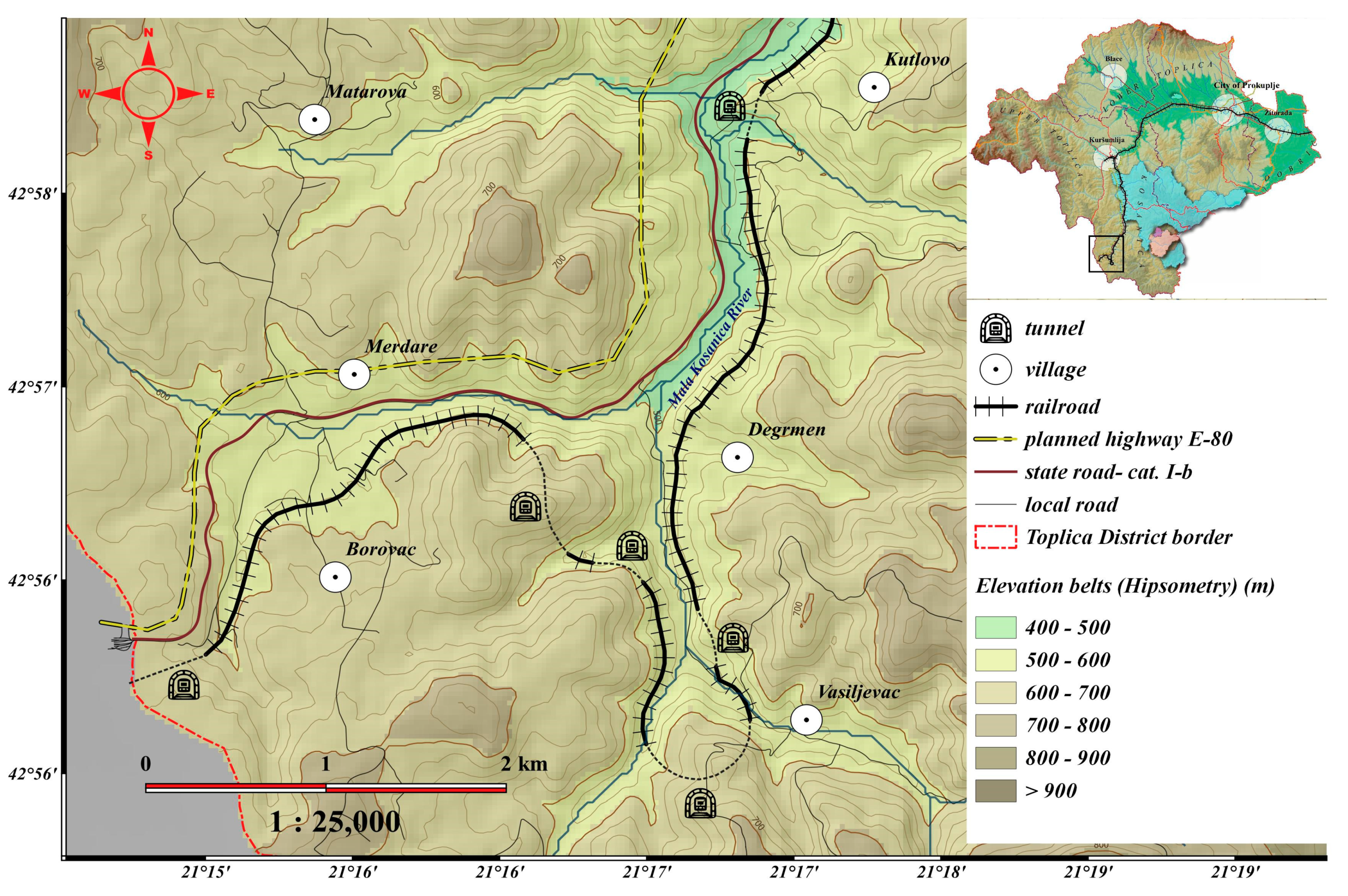
  • Technical-Operational State of Railways Criterion: This criterion considers only rural and underdeveloped (marginalized/devastated) local spatial units through which the routes of public railways pass, which, due to the technical-operational state of the railways, are no longer in use [61]. This includes railway lines that have been abandoned, but their reuse is possible after revitalizing some sections. By overlaying the network of public railways with the already identified local spatial units (91 in total) based on the first two criteria, it was determined that the route of the public railway passes through 47 rural and underdeveloped local spatial units, which are included in further evaluation. Data on the technical-operational condition and abandoned tracks were obtained through interviews from the joint-stock company managing railways in Serbia, “Railway Infrastructure of Serbia” [62]. According to the information received, the dismantling and complete removal of old rails and railway infrastructure is currently taking place on 15 local railways, with a total length of 435 km in 26 municipalities, in order to free up 590 ha of land. These are railroads whose operation and maintenance were not profitable, and modernization had no economic or traffic justification. By analyzing the spatial correlation of the identified rural areas and the obtained data on the technical and operational condition of the railways, it was determined that railways are active in 25 out of 47 local spatial units. Abandoned local railways, scheduled for dismantling, were recorded in the area of 6 local units, while inactive regional and European railways were recorded in the area of 15 local units. However, in most cases, these are temporarily inactive regional routes, which are out of service due to reconstruction, electrification, and modernization.
Considering all the criteria mentioned above, the regional railway number 223 Niš (Doljevac)–Kosovo Polje, passing through the Toplica District, meets all the specified criteria.

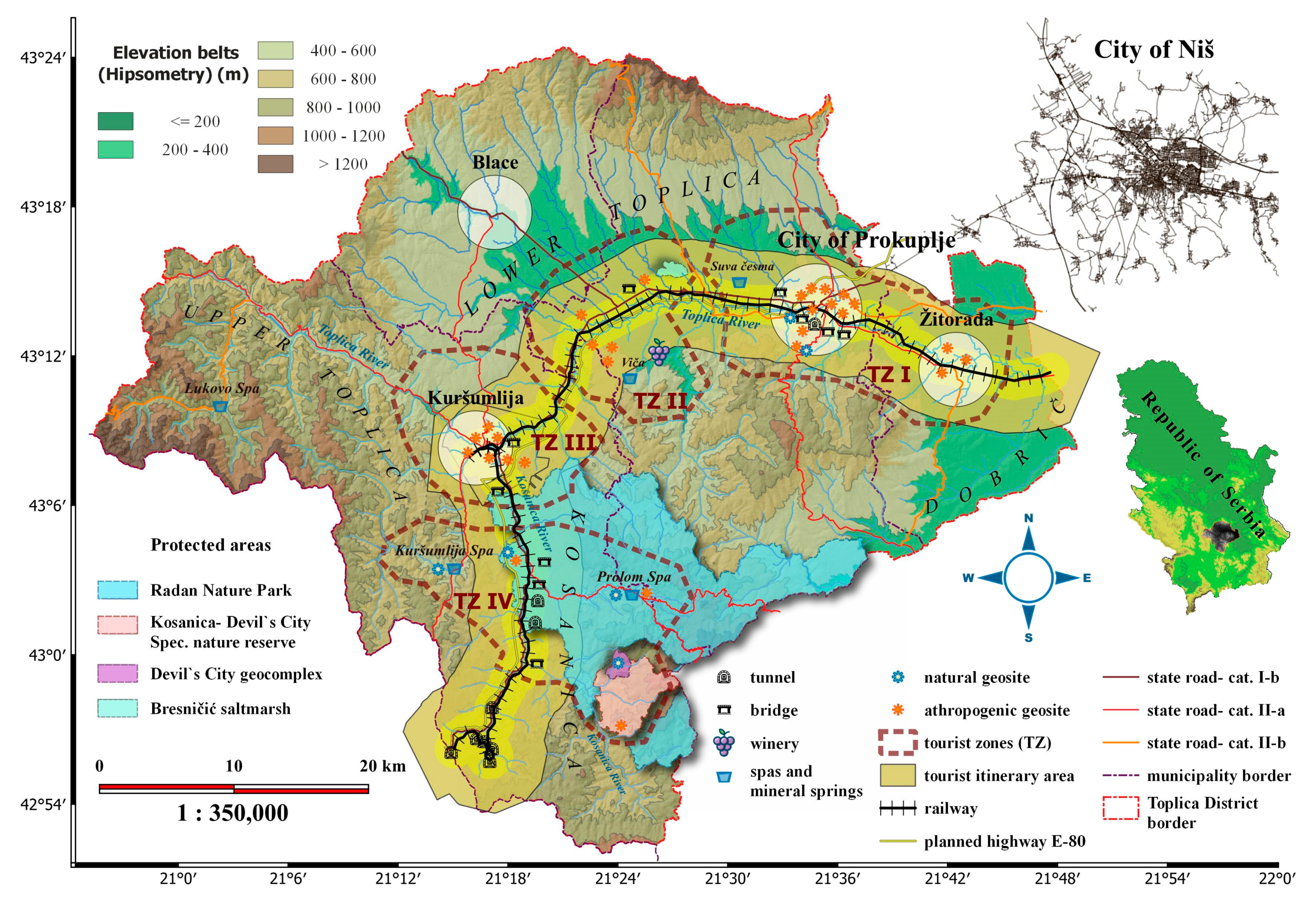
2.2. Description of the Study Area

The basis of this research is the single-track regional non-electrified railway number 223, running on the route Niš (Doljevac)–Prokuplje–Kastrat (Kuršumlija)–Merdare–Kosovo Polje, with branch 222 (Kuršumlija–Kastrat). The railway passes through three local spatial units in the Toplica District (Žitoradja, Prokuplje, and Kuršumlija). The Toplica District is an administrative region situated in the southern part of Serbia in the valley of the Toplica River, covering an area of approximately 2231 km2 with a population of 77,341. The railway traverses 35 settlements, including two urban centers—Prokuplje and Kuršumlija—with a combined population of 46,722 inhabitants (60% of the district population) and indirectly connects over 200 settlements within its wider zone. According to OECD criteria, all the mentioned local spatial units are classified as rural areas. Based on the Decree on the Establishment of a Unified List for the Development of Local Self-Government Units in Serbia [60], the local self-governments in this district are classified as underdeveloped and extremely underdeveloped/devastated. Prokuplje is categorized as an underdeveloped local self-government, while the municipalities of Kuršumlija and Žitorađa are classified as extremely underdeveloped and devastated. Historically, the railway served as a vital strategic link, connecting Kosovo and Metohija (KaM) with the Pan-European Corridor X and facilitating the connection of two regional centers, Priština and Niš [63]. However, during the 1999 war in KaM, the “Merdare” tunnel, crucial for connecting Toplica District with the area of KaM, was disabled and has not been restored since. Train traffic was suspended, and subsequently, freight and passenger traffic were limited to the Niš (Doljevac)–Merdare route, often interrupted due to maintenance and repair work on the railway. In recent years, flash floods in 2020 damaged certain sections of the railway, causing occasional disruptions in rail traffic. Presently, the railway is abandoned, with no operational train services. While the infrastructure may appear neglected and dilapidated, field research confirms that trains can still operate along most of the route. Basic traffic signals are in place, and the bridges and tunnels are structurally sound and functional. However, a partial reconstruction and modernization of the railway is necessary to ensure unrestricted use in the future. Since its initial construction, the railway has not undergone reconstruction; only ongoing maintenance has been carried out. The maximum permitted speed is 60 km/h [63]. Existing planning documents outline its modernization and electrification [64], but these plans have not been realized even a decade after their adoption.

2.3. Model of Tourism Evaluation of Abandoned Railways (TEAR Model)

In this study, a model for the identification and valorization of tourist values and the attractiveness of abandoned railways has been developed and proposed for their transformation into tourist itineraries/routes for use in tourism-commercial purposes (TEAR model). The defined model comprises a total of 27 sub-indicators proposed by the authors, categorized into 4 groups of indicators: natural tourist values (NV), anthropogenic tourist values (AV), tourist attractiveness of the railway (TA), and functional values (FV). The NV indicator group consists of 4 sub-indicators (SINV), the AV indicator group consists of 6 sub-indicators (SIAV), the TA indicator group consists of 9 sub-indicators (SITA), while the FV indicator group consists of 8 sub-indicators (SIFV) (Table 1). The authors proposed the structure of the model and indicators by drawing on similar models for valorization, adapting them to local conditions and the study’s objectives. The model used in this study incorporates some modified indicators from widely used models. The selection of indicators resulted from expert consultations and discussions of authors and independent experts in the form of a round table held on the sidelines of a scientific conference in the organization of the Association of Spatial Planners of Serbia (in October 2023), during which relevant indicators were identified and subsequently refined to an optimal number through a process of generalization and professional evaluation by the authors and experts.
The model is developed based on scientifically validated and well-established methods of tourist valorization and assessment, drawing on the available relevant literature. In the literature, there exists a scientifically grounded model that has been applied multiple times for the evaluation of cultural routes [65,66,67]. However, there is currently no scientifically based model specifically tailored for the tourist valorization of abandoned railways. The proposed model is theoretically and methodologically a modified and enhanced version of the method utilized by researchers such as Božić and Berić [65], Božić and Tomić [66], Antić [67], Tomić and Božić [68], Božić and Tomić [69], Yan et al. [70], Ristić et al. [71,72], Petrović et al. [73], Tomić and Košić [74], Sanchez Rivero et al. [75], and Vukoičić et al. [76] in their studies on tourism evaluation. All sub-indicators were subsequently prioritized and assessed for importance by the author and geoexperts, primarily consisting of spatial planners, tourismologists, and geographers, in order to preserve the objectivity and credibility of the answers. Sub-indicators were individually evaluated by a total of 33 geoexperts, to whom the purpose of the research and the method of evaluation were presented by the authors so that they could express their opinions more clearly. In order to minimize subjectivity, quantitative and measurable data were valorized with the help of QGIS software 3.18 (Table 2). Following their preferences, the sub-indicators within each indicator group were ranked [77] based on their significance in shaping a tourist itinerary/route. This resulted in rankings within each group of indicators, with NV sub-indicators ranked from 1 to 4, AV sub-indicators from 1 to 7, TA indicators from 1 to 9, and FV sub-indicators from 1 to 8. Once the sub-indicators were ranked (Equation (1)), the weight (weighted value) for each sub-indicator was determined (Equation (2)), ensuring that their cumulative sum equaled to a value of 1 [72,73,77].
The measured value of each rank was calculated by the following equation:
R i = M A X i + 1 i / Σ   I
The weight of the sub-indicator was calculated by the following equation:
W j i = Σ C j i R i / N
where
  • i represents the ordinal number of the rank,
  • j is a constant which refers to a given indicator (represents the ordinal number of the sub-indicator),
  • Ci is the number of occurrences of the i-th rank for the given sub-indicator,
  • N is the sample size.
Subsequently, the authors conducted the valuation of the tourist itinerary based on the specified sub-indicators and their rankings, employing a 5-grade/value scale [70,72,73,77]. The ratings and corresponding value categories are outlined in Table 1.
Utilizing the devised TEAR model, which includes defined groups of indicators, sub-indicators, and their rankings, the authors/experts assigned a value to each sub-indicator, contributing to the determination of the tourist value of the abandoned railway. The mean value of the grades for each sub-indicator was computed using Equation (3).
The weight of the sub-indicator was calculated by the following equation:
V s = V i / N
The total value for each sub-indicator and group of indicators was calculated using the following equation:
V u = W j i V s
where: V s is the mean score for the i-th sub-indicator in the j-th set of indicators; V u is the total value of the indicator/sub-indicator.
Ultimately, the tourist evaluation model for abandoned railroads will be established as the aggregate of values from four indicator groups (natural tourist values—NV, anthropogenic tourist values—AV, tourist attractiveness—TA, and functional value—FV) divided by four (the total number of indicator groups).
TEAR = (NV + AV + TA + FV)/4
According to the outcomes of the TEAR model (Equation (5)), the disused railway can be categorized into one of three tourist value levels: low tourist value (V < 0.4), moderate tourist value (0.4 ≤ V < 0.7), and high tourist value (0.7 ≤ V < 1) [70,72,73].
Information regarding protected natural and cultural assets was sourced from the online register of protected natural assets in Serbia, administered by the Institute for Nature Protection [78], as well as from the register and information system of immovable cultural assets managed by the Republic Institute for the Protection of Cultural Monuments [79]. Through field research aided by GPS devices and mobile applications, all tourist values in the immediate vicinity of the railway, as well as tourist-attractive elements along the route itself, were identified. Geospatial data from topographic maps, tourist maps, local development strategies, and spatial plans (including maps and graphics from spatial plans, traffic maps, etc.) were also utilized. The basic GIS database was constructed using vectorized content from these maps and open-source databases such as the CORINE Land Cover database [81], European digital terrain model (EU-DEM v1.1) with a resolution of 25 m [80], and OpenStreetMap data (Table 2).
An integral component of the methodology involves the use of a Geographic Information System (GIS), providing support across all research phases. Software such as QGIS 3.18 and advanced GIS tools were employed for tasks such as mapping tourist values, conducting intricate geospatial analyses, evaluating defined indicators, and producing graphic materials. Spatial analysis was facilitated using the System for Automated Geoscientific Analyzes (SAGA) extension within the software. QGIS software tools (including SAGA extension, buffer analysis, and other tools) that enable geospatial analysis were utilized for hypsometric assessment of the Digital Elevation Model (DEM), analysis of the CORINE Land Cover database, and determining distances and spatial correlations among railways, tourist attractions, broadcasting and visitor centers, roads, as well as hotel and restaurant services.

3. Results

The findings from this study indicate the presence of substantial natural and anthropogenic tourist attractions within the vicinity of the abandoned railway. The railway could act as a connector, integrating these attractions into a comprehensive tourist spatial-functional system. Table A1 provides an overview of all identified natural and anthropogenic tourist values situated in the zone of the abandoned railway.
Geospatial GIS analysis has identified the clustering and concentration of both natural and anthropogenic tourist attractions, in close proximity to the railway. This spatial arrangement allows for the integration and connection of these attractions into a cohesive tourist itinerary (Figure 1). The strategic alignment of tourist values alongside the railway and the subsequent formation of a tourist itinerary are considered economically, socially, and ecologically justified.
In contemporary times, the spatial arrangement of tourism plays a crucial role in comprehensive economic development. Therefore, a proposal for the spatial organization of tourism has been put forth, centered around the established tourist itinerary. Through spatial analysis, four potential tourist zones have been identified, serving as focal points for concentrated tourist sites and values along the planned itinerary (Figure 1; Table A1).
Within these distinct zones, the primary tourist offerings will be systematically arranged. The prospective tourist itinerary aims to interconnect and amalgamate various tourist attractions and resources with emission centers, acting as organizational hubs for the tourist offerings. Additionally, the itinerary links the specified tourist zones along the railway, facilitating a comprehensive exploration of the district and the decentralized growth of tourism.
Due to the amalgamation of diverse value groups, the tourist itinerary assumes a composite character. Through an analysis and categorization of identified tourist attractions along the railway into interconnected chronological and thematic clusters, the anticipation is to develop and combine several thematic routes:
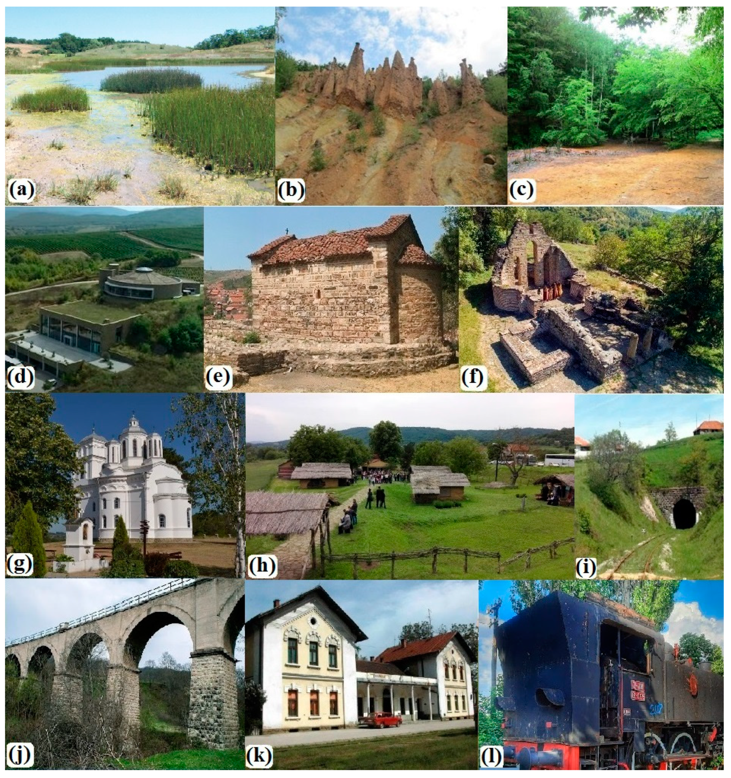
  • The thematic route “Roads of the Heroes of the Battle of Kosovo” is designed to link the fortifications associated with Serbian knights and heroes of the Battle of Kosovo, including Jug Bogdan, Milan Toplica, and Ivan Kosančić. It also encompasses the battle site in Pločnik (Pločnik Settlement), where a historic victory over the Ottoman Empire was achieved in 1386. This route provides an opportunity to recreate pivotal historical events and captivate tourists with engaging narratives.
  • The themed route “Serbian Medieval Cities and Fortifications” establishes a connection between several significant medieval sites. This route links the medieval town called Hissar, the Jug Bogdan’s Tower, and the medieval religious structures on the hill of Hissar near Prokuplje. It further extends to Kuršumlija, the former capital of medieval Serbia during the rule of the Nemanjić Dynasty, encompassing landmarks such as the Mara’s Tower, the first and oldest endowment of the Nemanjić Dynasty, the Monastery of St. Nicholas, and the remnants of medieval towers (Branko’s Tower, Jug Bogdan’s Tower, Milan Toplica’s Tower, and Ivan Kosančić’s Tower). The route offers an opportunity to recreate significant historical events and engage tourists with captivating stories.
  • The thematic route “Prokupac—Wine Roads” takes travelers through Toplica Vineyards, the birthplace of the renowned autochthonous grape variety, “Prokupac”. The journey includes a visit to the winery, providing an opportunity to learn about grape picking customs and the process of wine preparation. This route offers a rich experience for enthusiasts interested in exploring the cultural and viticultural aspects associated with the Prokupac grape.
In addition to the thematic routes mentioned, numerous natural tourist attractions also facilitate the organization of adventure, recreational, and ecological tours.
The significance and weight of each sub-indicator are presented in Table 3. According to the conclusive outcomes of the TEAR model, natural tourist values (0.84) and the route’s tourist attractiveness (0.82) achieved the highest overall ratings. Through the assessment of the railway route and its components, it was affirmed that the route holds significant appeal for tourists. While anthropogenic tourist values, despite being most abundant along the railroad, received a slightly lower rating (0.77), all these ratings fall within the high category (≥0.7). On the other hand, functional tourist values of the route obtained the lowest score (0.5), categorizing them as medium tourist values (0.4 ≤ V < 0.7). The cumulative tourist value of the abandoned railway, determined by the TEAR model, stands at 0.73, indicating a high classification within the spectrum of tourist values.

3.1. Tourist Attractions of a Natural Origin within the Vicinity of the Abandoned Railway

The Toplica District is recognized for its outstanding natural heritage values and significant geotourism resources [83]. In the broader vicinity of the abandoned railway line, considerable natural tourist values have been documented (Table A1). Consequently, the planned itinerary’s natural tourist values received the highest rating value (0.84). Protected natural areas, cataloged in the Central Register of the Institute for Nature Protection of Serbia [78], are particularly noteworthy among these natural tourist values. The sub-indicator reflecting their presence received the highest rating in the NV group (0.4). All protected natural areas of the Toplica District are connected by a railroad. The most prominent and diverse natural values are situated in the hilly-mountainous segment of the route, between Kuršumlija and Merdare. The railway crosses the Radan Nature Park, a category I protected area, specific for numerous forms of geoheritage, volcanic landforms, hydrographic phenomena, and preserved biodiversity, which cover approximately 413 km2. Along the middle section of the railway, between Prokuplje and Kuršumlija, lies the protected habitat “Bresničić Saltmarsh”, with more than 32 bird species, six amphibian species, seven reptile species, and more than 70 plant species (Figure 2a). Of particular note is the category I Nature Monument Devil’s Town (67 ha) (Figure 2b,c), a unique geomorphological phenomenon in Serbia created as a result of distinct erosive processes [84,85]. Comprising 202 earthen figures of varying shapes and dimensions (ranging from 2 to 15 m in height and 0.5 to 3 m in width) crowned with stone caps, Devil’s Town was Serbia’s nominee for the selection of the “7 Natural Wonders of the World” and is under consideration for inclusion in the UNESCO world natural heritage sites [85]. Expanding the protected area in the wider railway zone is currently underway, incorporating the Nature Monument “Devil’s Town” along with specific geomorphological features and paleovolcanic mounds in the Kosanica area. This region is designated as a category I Special Nature Reserve, “Kosanica-Devil’s Town”, of international, national, and exceptional importance.
The hydrographic features along the railway are also noteworthy, ranking as the second-highest-rated sub-indicator (0.28). The thermal mineral springs in this region represent a significant tourist resource [83]. Numerous occurrences of thermal and mineral springs have been identified, including two lesser-known ones, Suva Česma (24 °C) and Milan Toplica—Viča (19.2–21.5 °C), which are currently untapped [86]. The thermal mineral springs of Prolom Spa (31 °C) and Kuršumlijska Spa (68 °C), one of the hottest in Serbia, are utilized for health and wellness tourism [83,87]. The watercourses of the first order, such as the larger relays of Toplica and Kosanica, along with numerous plain and mountain streams, constitute a genuine natural wealth. The railway intersects watercourses in as many as 30 locations. Around the urban settlement of Prokuplje, near the Hissar Hill, the Toplica River traverses a higher part of the terrain comprised of more resistant rocks, creating the illusion of flowing upstream. This process results in the formation of a crested epigeny, a rare hydrological phenomena that is distinctive in Serbia and uncommon worldwide.

3.2. Anthropogenic Tourist Attractions within the Vicinity of the Abandoned Railway

Numerous remnants attest to the presence of diverse cultures and civilizations, making the Toplica District rich in cultural heritage and giving it notable anthropogenic tourism values. Evident traces span from the early Neolithic culture to the Roman period and medieval Serbia, highlighting a profound cultural and historical legacy. The evaluation of anthropogenic tourism values considered various sub-indicators illustrating the presence of diverse cultural attractions. Immovable cultural assets, meticulously documented in the Central Register and the information system of immovable cultural assets by the Republic Institute for the Protection of Cultural Monuments of Serbia [79], stand out as the paramount cultural values. Anthropogenic tourism values received a high rating of 0.77, with the highest-rated sub-indicator being tourist places (0.21). In terms of quantity, these values are most abundant in the zone encompassing the abandoned railway. In this relatively small area, there are three spa settlements, two of which (Prolom Spa and Kuršumlijska Spa) are located in the wider area of the abandoned railway [74]. Additionally, the “Toplica Vineyard” Winery, recognized as one of the largest private wineries in the Balkans, is situated within the railway zone (Figure 2d).
The most prominent medieval traces in the area are the remnants of fortifications, including cities, fortresses, and towers. Among the six identified fortifications, four hold state protection status as cultural monuments and immovable cultural assets of significant importance. The sheer number of these fortifications, coupled with their cultural, historical, and tourist significance, contributed to this sub-indicator receiving one of the highest ratings (0.2) in the anthropogenic tourism values (AV) group. Notable examples include the remains of the medieval fortress named Hissar, constituting the old core of Prokuplje, situated on the hill above the current town. Another significant site is the remains of the medieval town near Kuršumlija, known as the “Marina Tower”. Additionally, three medieval Serbian knight towers associated with Jug Bogdan, Milan Toplica, and Ivan Kosančić have been identified (Table A1, Figure 1). Among these, Ivan’s Tower stands out as the best-preserved, reaching a height of 14 m and constructed at the top of the paleovolcanic dome [83].
There are a total of 13 religious buildings in the area, with 9 enjoying state protection as cultural monuments (Figure 2e–g). Consequently, this sub-indicator is among the highest-rated in the anthropogenic tourism values (AV) group, receiving a rating of 0.14. Notably, five significant buildings, protected as cultural monuments, are situated within the railway zone. Four historical monuments bear witness to the events at the close of the 19th century and the beginning of the 20th century, spanning the period of the liberation wars against the Ottomans, the Balkan Wars, and the First World War. These monuments highlight the contribution of the Second Infantry Regiment “Knjaz Mihajlo”, composed of the local population and affectionately known as the “Iron Regiment” due to its courageous actions (the Mačkovac Memorial to the fallen fighters of the Toplica Uprising, the Monument to the fallen residents of Toplica in the wars of 1912–1918, and the Memorial Park and memorial room dedicated to the “Heroes of the Iron Regiment”).
Two significant archaeological sites are situated in close proximity to the railway. One of them is the archaeological site of the Vinča culture from the Younger Neolithic period (5500–4800 BC) known as “Locality Pločnik” (Figure 2h), covering an area of 120 ha [88,89,90]. This site has yielded numerous artifacts of the Vinča culture, including house foundations, ovens, hearths, pits, hoards containing copper and stone tools, fragments of ceramic vessels, and figurative sculptures [79]. Additionally, there is the Roman Baths, an archaeological site dating back to the Roman Empire period (III or IV century). Constructed with stone and brick, this site comprises a pool with hot water (caldarium) and cold water (frigidarium), a larger changing room (apodyterium), and two smaller changing rooms [91]. Archaeological sites, as a sub-indicator of the anthropogenic tourism values (AV) group, hold significant value (0.1) compared to other sub-indicators.

3.3. The Appeal of the Route to Tourists

The railway route is highly appealing to tourists, particularly in the Kosanička region, characterized by winding tracks, frequent ascents, and numerous tunnels and bridges (Figure 2i,j). Covering a total length of 84 km, the route features nine tunnels (total length approximately 4593 m) and 30 bridges (total length approximately 913 m).
The majority of tunnels are concentrated in the section between Kuršumlija and Merdare (eight tunnels), with a single tunnel passing through the Hissar Hill in Prokuplje. In the settlements Vasiljevac and Merdare, the railway forms a “figure of eight” through four tunnels located in close proximity (Figure 3). One of the most captivating attractions for tourists is the “circular tunnel”, spanning over 800 m through the mountain massif, causing the route to make a 180-degree turn. The following tunnels are called “Mali Borovac” and “Veliki Borovac”, spaced only about 200 m apart. The route culminates in the “Merdare” tunnel, measuring 1.9 km and constructed with hard-cut stone. This tunnel traverses beneath the demarcation line between KaM and Central Serbia. It was sealed after 1999 and the armed conflicts in KaM. Indicators of the attractiveness of the railway route are presented in Table 4.
Among the 30 bridges along the railway, 12 cross larger rivers, while 18 traverse smaller rivers and streams. Constructed from various materials, predominantly steel or stone, these bridges contribute to the scenic allure. Notably captivating is the splendid stone bridge, often referred to as the “viaduct,” (Figure 2j) featuring four grand stone arches between Rača and Degrmen. The sub-indicators evaluating the quantity of tunnels and bridges on the railway receive high ratings in this indicator group, defining the overall tourist appeal of the route (0.12 and 0.11).
The railway embarks from a flat terrain and traverses hilly and mountainous regions, conquering an elevation difference of 633 m. The route reaches its lowest point at the Dobrič Plain (197 m above sea level). The highest point along the route is in Kosanica (830 m a.s.l.), navigating through more challenging hilly and mountainous terrains. The entire journey showcases a vibrant and diverse natural environment. In the valley and hilly sections, agricultural scenery predominates with fields, arable lands, orchards, and vineyards. As the route transitions into the hilly-mountainous areas, it traverses forested landscapes intertwined with numerous mountain streams. Notably, the railway ingeniously tackles a considerable elevation change over a short horizontal distance, reflecting the audacity and skill in the planning, design, and execution of the project [28]. Close to Pločnik, the railway shifts from plains to hilly-mountainous terrain, encountering a steeper ascent navigated through frequent and lengthy serpentine “S” curves, so the calculated winding coefficient of the railway reaches 1.58. Consequently, sub-indicators such as landscape heterogeneity (0.12), elevation difference overcome by the route (0.09), and the meandering pattern of the railway (0.08) significantly contribute to the overall assessment of the route’s tourist appeal.
The railway stations along this route embody genuine architectural and cultural heritage, showcasing intriguing and authentic designs (Figure 2k). The evaluation of this sub-indicator (0.05) holds substantial weight in determining the overall tourist appeal of the route. Through thoughtful adaptation, these stations have the potential to evolve into noteworthy tourist attractions and small museums along the planned itinerary. The Prokuplje station stands out, featuring an old locomotive as a captivating exhibit (Figure 2l). Moreover, the railway station building in Pločnik has already been transformed into a museum space, displaying artifacts unearthed at the archaeological site of Pločnik. The architecture of the warehouses and grain silos adjacent to the railway stations (such as Beloljin, Mala Plana, Žitorađa, etc.) adds to the overall interest. Some scholars suggest that such structures can evoke emotions that contribute to the prolonged stay of tourists, encompassing accommodation and food services. Some authors state that such buildings can cause emotions, which can affect the longer stay of tourists, which will have multiple significant effects for the local community [92,93].
The creation of the railway not only traverses the geographical landscape but also intertwines with the history of the regions it passes through, reflecting the prevailing conditions and the era in which it was established [28]. The construction method and the chronological unfolding of the railway’s development contribute significantly to its tourist allure. Drawing from archival materials and newspaper clippings housed at the National Museum of Toplica in Prokuplje [82], a chronology of the railway construction in Toplica was compiled, highlighting intriguing historical facts. The concept of constructing a railway emerged towards the end of the 19th century with the initial vision of connecting the Adriatic and Ionian seas with the Black Sea. The inaugural segment of the railway (Doljevac–Prokuplje) was officially inaugurated at the close of 1925, while the extension to Kuršumlija was completed in 1930. This coincided with the construction of the Šargan–Mokra Gora railway in the same year, which holds the distinction of being the sole railway in Serbia categorized as a museum tourist route. Consequently, the examined railway track is deemed unique and rare, meriting a rating of 0.07. The entire section from Niš to Priština was constructed and commenced operations after the Second World War, in 1948. Notably, the construction of the segment through Kosanica is particularly intriguing. It was built through labor actions and kuluks, imposed as a punishment on the population of this Chetnik region. The rails used in its construction date back to the early 20th century and are still predominantly in use on the route today.
This route presents a unique opportunity to delve into historical events and narrate captivating stories, making the sub-indicator of interpretative and animative possibilities (0.1) one of the higher-rated components within the TA group. Kuršumlija, a town traversed by the railway, holds historical significance as the first capital of Stefan Nemanja, the progenitor of the Nemanjić dynasty in Serbia. Here, he established his initial foundations, including the Monastery of the Holy Virgin and the Monastery of Saint Nicholas. The entire route is dotted with remnants of medieval fortifications. The railway passes through the site of the Battle of Pločnik in 1386, where forces led by Prince Lazar clashed with the Ottomans under Sultan Murat I. Not far from the route’s end, in 1389, the pivotal Battle of Kosovo unfolded, marking a temporary halt to Ottoman expansion into Europe. Adjacent to the railway stand the fortifications, known as towers, of prominent Serbian knights who perished in this significant battle—such as the Jug Bogdan’s Tower, Milan Toplica’s Tower, and Ivan Kosančić’s Tower. During the First World War, specifically in February–March 1917, the Toplica Uprising occurred in this region, representing the sole uprising in an occupied country during the conflict. The story continues with the Second Infantry Regiment “Knjaz Mihajlo” of the Serbian Army, a unit celebrated for its bravery and steadfastness during the wars of 1912–1918, a reputation that led to the regiment being bestowed with the moniker “Iron Regiment”.

3.4. Functional Values within the Area of the Abandoned Railway

Within the assessed categories of indicators, those pertaining to functional tourism values received the lowest overall score (0.5). This is attributed to the diminished values across several indicators. The absence of visitor centers along the route or in its vicinity has impacted the scores. Additionally, the lack of an organizing entity responsible for managing the potential route has resulted in the absence of a route management plan. While there is an initiative and proposal from a group of researchers for the transformation of the route, an official document outlining the plan’s details does not currently exist. While the regional spatial plans and municipal spatial plans addressing this railway anticipate its revitalization, the actual implementation of this activity has not occurred within the designated timeframe. Touristic infrastructure is only partially developed in specific localities and places along the railway that have already been confirmed for tourism, such as Devil’s Town, Prolom Spa and Kuršumlijska Spa, Pločnik, and Hissar Hill with the monument complex. Except for municipal centers like Žitorađa, Prokuplje, and Kuršumlija and spas like Prolom Spa and Kuršumlijska Spa, there is a lack of built-in accommodation facilities or notable catering establishments in other parts of the route.
The primary functional advantage lies in the railway line’s passage through three municipal centers—the urban settlements of Prokuplje, Kuršumlija, and Žitorađa. These centers not only serve as communication hubs but also concentrate various service facilities and amenities, including diverse accommodation options, restaurants, and cafes. Moreover, the railway is situated within the functional sphere of the regional center of Niš, which stands as the most significant and largest urban center of the South Serbia. The railway boasts excellent connectivity and proximity to vital road networks, particularly the Pan-European Corridor X to which the railway route is directly linked. Additionally, it aligns with the route of the state road IB (part of the European Route E80), and the state road IIA, throughout its entire length. This strategic positioning enhances the overall functionality of the railway.

4. Discussion and Conclusions

In existing development documents, the designated purpose of the mentioned railway is primarily geared towards transportation needs, serving the conveyance of goods and passengers. However, due to a decline in the traffic of both goods and passengers at the beginning of the 21st century, the railway saw limited use and activity. Prior to its abandonment, only one line of normal-speed (very low speed) trains operated on this route according to the timetable, running at incomplete capacity and on the verge of sustainability. Considering these circumstances and the fact that the railway traverses a sparsely populated area, which has increasingly shifted towards road traffic in recent years, the premise of this research suggests the potential for utilizing the railway not only for its fundamental transportation purpose but also for tourist-commercial purposes. The existing infrastructure of the railway, including stops with tracks for passing and railway triangles, presents an opportunity for the simultaneous operation of regular traffic and tourist tours. Specifically, there is a triangle in Kuršumlija that allows the train to travel to Merdare (and vice versa to Niš) without entering Kuršumlija directly. The railway features a total of 27 stations, comprising 9 railway stations (Žitoradja, Prokuplje, Mala Plana, Beloljin, Kuršumlija, Kastrat, Rača, Degrmen, and Merdare) and 18 railway stops.
Considering the outcomes of this study, the reimagining of the abandoned railway in the rural marginal area, as per the proposed concept/model, is directly aligned with the pursuit of all five SDGs and partially or immediately addresses two additional goals. According to Plum et al. [94], the diverse scope of SDGs proves advantageous, allowing each country and community to identify with specific goals and make meaningful progress tailored to their unique contexts. In terms of addressing current and future challenges, the transformation of the railway in the rural marginal area aims to contribute to several goals (Table 5). Notably, it aligns with Goal 1 (No Poverty), Goal 8 (Decent Work and Economic Growth), Goal 9 (Industry, Innovation, and Infrastructure), Goal 10 (Reducing Inequality), Goal 11 (Sustainable Cities and Communities), Goal 15 (Life on Land), and Goal 17 (Partnerships for the Goals). Furthermore, it has a partial impact on the achievement of Goal 12 (Responsible Consumption and Production). Overall, the SDGs focus on contributing to a healthy planet with fairer and more resilient societies immersed in economically prosperous regions [95]. To achieve SDGs, local public administrations need to focus on a gradual progressive transformation of economic and administrative systems related to resources in order to promote SD projects that benefit current and future generations [36].
The planning and execution of a tourist itinerary through the transformation of an abandoned railway holds numerous economic and social advantages, directly aligning with the SDGs in the economic and social sectors. In contemporary times, the spatial organization of tourism is recognized as a crucial component of overall economic development [96]. The proposed concept for transforming the abandoned railroad and organizing tourism along the established itinerary would significantly enhance the tourism industry in the area. The anticipated impact of tourism on this rural and underdeveloped region extends beyond immediate economic benefits. Tourism is expected to act as a catalyst for development, generating multiplier effects that contribute to the livelihoods of the local population. The repurposing of the railway for tourist-commercial activities necessitates the engagement of human resources, the establishment of service points along the railway, and the creation of new employment opportunities. This approach not only strengthens the local economy but also fosters the development and economic growth of an underprivileged area (Goal 8). Additionally, it offers the prospect of revitalizing rural areas and reducing inequality concerning the development poles in Serbia (Goal 10). By generating new jobs in the tourism and hospitality sectors, the local population gains access to dignified work, economic prosperity, and a pathway to reducing inequality, rural poverty, and hunger, aligning with the projected SDGs 1, 2, 8, and 10. Fundamentally, the study advocates for an innovative concept and model to transform outdated and dilapidated abandoned railways, industrial warehouses, and depots into sustainable and purposeful systems, thereby revitalizing existing railway infrastructure. This approach directly contributes to the achievement of SDG 9 (industry, innovation, and infrastructure). Moreover, the overall initiative enhances the sustainability of communities and settlements, both cities and villages, through which the railway passes, aligning with the vision outlined in SDG 11.
This study is closely aligned with the ecological subset of SDGs. The extensive linear infrastructure system, spanning 84 km, along with its associated facilities, currently occupies a considerable unused land area. This expanse poses environmental challenges typical of brownfield sites while simultaneously serving as a significant spatial resource. In line with the principles outlined by Grimski and Ferber [97], the revitalization and regeneration of brownfields are essential tools for achieving sustainable development and implementing effective land management. The core focus of this study revolves around transforming the abandoned railway into sustainable and functional systems, optimizing the use of both the deserted infrastructure and the land as valuable, non-renewable resources. Activation and enhancement of this system not only contribute to the enhancement of the rural landscape but also support planning, protection, and sustainable use of protected natural areas, aligning seamlessly with the objectives of SDG 15 (Life on Earth). Moreover, the proposed concept of spatial tourism organization, based on the established itinerary, offers a comprehensive tour of the Toplica District, fostering dispersed tourism development. This approach contributes to nature and environment preservation by mitigating the concentration of tourists in specific zones, thereby addressing the challenges associated with mass tourism. Creating a designated tourist itinerary ensures accessibility to railway zone attractions for a larger audience without resorting to construction in environmentally sensitive areas. These efforts collectively promote the realization of SDG 15 (Life on Earth). The proposed transformation not only addresses immediate economic and social needs but also ensures a more sustainable and resilient future for the regions involved.
The final objective in the SDG (SDG 17) series advocates for the establishment of effective global partnerships to facilitate sustainable development and the realization of SDGs. Among the most prevalent collaborations, particularly involving local public administrations (LPAs), are partnerships formed with tourism stakeholders, universities, public entities, and other local authorities, as well as entities managing funds [36]. Viewed from this perspective, the study actively contributes to the pursuit of the SDGs. Foremost among these collaborations is the partnership between university professionals and local authorities. A primary aim of this locally focused study was to engage scientists and researchers in the formulation of innovative ideas and mechanisms to achieve one or more SDGs. Through the introduction of creative ideas and sustainable concepts in the planning and development of local spaces, researchers provide valuable support to local administrations in the implementation of SDGs. Most of the SDGs clearly state that national governments are responsible for the localization and implementation of the SDGs, but local governments need to be held accountable for delivering progress in the SDGs [98,99]. According to the Sustainable Development Solutions Network (SDSN), without proper engagement and coordination of local authorities, 65% of the SDGs will not be fully achieved [100]. It is crucial for Local Public Authorities (LPAs) to devise mechanisms for incorporating the SDGs into their local development strategies and initiatives. Local authorities should actively engage in the transition of economic models, adopting sustainable methods that can foster positive economic changes across various sectors, ultimately working towards the realization of sustainable development as outlined by the UN goals [36,101]. Many SDGs focus on activities that are LPAs’ responsibility, placing special importance on initiatives in which administrative, political, and sustainability issues interact [36]. Local governments are closer to regional populations, so these entities can identify local communities’ needs and priorities, recognize their potential, and promote shared initiatives based on the SDGs as facilitators of change [102]. To avert the complete deterioration and disappearance of the railway, a team of researchers affiliated with the university initiated and proposed a plan for the revitalization and modernization of the railway, recognizing its essential transformation for use in tourist-commercial endeavors. The preparation of this study serves as a form of support and experts’ professional contribution to local administrative bodies, aiding in institutional development and capacity building for the formulation and enhancement of local development plans. The study actively contributes to local and regional development, encompassing the amelioration of the rural landscape and the revitalization of rural areas. The envisioned approach involves a multi-level partnership, necessitating active coordination among competent entities managing the identified natural values (such as the Institute for Nature Protection of Serbia and Public Enterprise Planinka), anthropogenic values (like the Republic Institute for the Protection of Cultural Monuments and Public Enterprise Planinka), the railway and associated facilities (Railway Infrastructure of Serbia a.d.), and local tourist organizations and administrative bodies dedicated to the development, improvement, and promotion of tourism. This collaborative partnership aligns with Goal 17, which advocates for effective partnerships in achieving the SDGs. Enhancing both the infrastructure and the touristic appeal of the routes, particularly regarding functional aspects like tourist facilities and services, necessitates active collaboration among the entities mentioned. The study’s implementation can be facilitated through their involvement, partnership, shared responsibilities, and collective financing efforts. Besides the budgets allocated by local and national authorities and institutions, linking the study to the Sustainable Development Goals (SDGs) opens up avenues for securing funding from EU sources, including instruments for pre-accession assistance such as IPA III 2021–2027, particularly the IPARD III program, the Western Balkans Investment Framework, and others.
While the idea has been thoroughly developed through the author’s research, and there is expressed interest from competent local authorities such as tourist organizations and local authorities, the primary obstacle to the planned transformation of the railway lies in the absence of an established planning and legal foundation. Specifically, this idea has not yet been integrated into legally binding planning documents, which would serve as the planning and legal basis for launching this initiative. Nonetheless, there is a solid foundation for the future implementation of the idea to transform this railway. In Serbia, the planning of spatial organization and tourism development follows documents adopted in accordance with the Law on Planning and Construction. These encompass integral planning documents, wherein tourism constitutes one segment and serves as the foundation for construction. Examples include regional spatial plans, local spatial plans, or spatial plans for special purposes. Additionally, planning is guided by documents adopted according to the Law on Tourism, such as sectoral plans, programs, and strategies (e.g., tourism development strategies, tourism development master plans, etc.), which specifically focus on tourism, and their provisions are incorporated into spatial plans. Introducing this solution during the formulation of the mentioned documents would establish a planning and legal basis for the comprehensive realization of this activity. Another crucial management activity, indispensable for the planned transformation, involves amending the Regulation on the Categorization of Railways [61]. This amendment aims to reclassify the valued railway from the category of regional railways to the category of museum-tourist railways.
A solid foundation for transforming the abandoned railway into a tourist itinerary already exists, evident in the recognized tourist values and the attractiveness of the railway route. However, the main limitation lies in the identified functional values. As indicated by the TEAR model results, the functional values of the route received the lowest scores. Consequently, the focus of planners and the investment direction in the future should prioritize the development and enhancement of these functional determinants. A mitigating factor is that functional values can be upgraded through proper planning and strategic allocation of funds to improve the sub-indicators influencing the functional values of the route. This primarily involves establishing an organization dedicated to managing the route, enhancing tourist infrastructure, and providing additional service offerings and amenities within the railway zone.
The results derived from this model serve as valuable insights to identify optimal ways of utilizing abandoned railways and to strategically plan their transformation. The proposed TEAR model for the valorization of abandoned railways represents a novel contribution in the scientific realm and can have broad applicability at the global level for similar case studies. The development of the TEAR model has effectively addressed the identified research gap, offering a clear methodological framework for the tourism valorization of abandoned railways. This framework holds potential significance for other researchers, scientists, and policymakers. The study’s international relevance becomes evident, particularly considering the growing importance of railway transformations, a trend likely to persist in the future. The proposed concept for repurposing abandoned railways and the outlined TEAR model, while grounded in a specific case study, possess a broad applicability that extends beyond regional boundaries. Their general nature renders them suitable for adoption and implementation at the international level and in similar contexts where abandoned railways exist. Furthermore, we highlight several identified limitations that warrant consideration in future research endeavors. Firstly, there arises a question regarding the potential for broader application. The model was formulated based on a local case study in Serbia and, moving forward, necessitates adaptation to varying local conditions globally, across different spatial scales. The assumption posits that it may be utilized without constraints and enhancements in Western Balkan countries, which share analogous spatial, social, and developmental conditions. Consequently, the TEAR model may necessitate specific modifications and adjustments contingent upon particular local, regional, or national circumstances. While the defined indicators are authentic, the model remains flexible for the modification of indicators, sub-indicators, and ranks tailored to specific valorization needs. It can be adapted to local conditions and regional specificities, offering a versatile framework for assessing abandoned railways. Another potential limitation lies in the challenge of subjectivity, stemming from the inability to qualitatively involve local residents and tourists in the model’s development, which could mitigate the potential subjectivity of experts. This limitation is also evident in numerous other models used for evaluating tourist values. Our field research and direct interactions with the local population revealed fragmented education and knowledge regarding the terminology related to the study and its topic. Consequently, we cannot integrate the local population into the selection of key indicators, sub-indicators, and subsequent evaluations. Since the railway is in its initial transformation stage and is not yet utilized for tourist-commercial purposes, we could not incorporate tourists as direct service users in the selection and evaluation procedures. Additionally, another limitation arises from the current inability to compare the study’s results. To our knowledge, there is no existing literature on this particular model, making it impossible to compare the study’s results, where the model was tested for the first time. Through future research, the model could be enhanced in several aspects.
In future endeavors, our aim is to enhance the foundational model we have developed by incorporating the perspectives of both the local population and tourists in the selection processes of indicators and sub-indicators, as well as in the evaluation of tourist values. This inclusion serves as a measure to mitigate potential subjectivity and ensure a more comprehensive assessment. Future steps could involve upgrading the model to include not only expert perspectives but also incorporate the input of tourists and local residents, who are direct users of the space, in the valorization process. Furthermore, it is essential to engage a diverse array of experts from various disciplines to ensure the comprehensiveness and objectivity of the evaluation. This includes professionals such as traffic engineers, conservators of cultural assets, ecologists, archaeologists, and others. However, in this study, despite efforts, there was a lack of interest expressed by these experts in participating. Moving forward, the developed TEAR model must undergo further testing on a non-valorized railway already utilized for tourist and commercial purposes. The broader application of this model presents the opportunity to compare and rank the tourism valorization results of abandoned railways on a global scale, fostering a more comprehensive understanding of their potential transformations.

Author Contributions

Conceptualization, D.R.; methodology, D.V. and D.R.; software, M.I. and D.P.; validation, D.R., M.N., N.M. and L.M.; formal analysis, D.R., D.V. and D.P.; investigation, D.R., D.V., M.I., N.M. and L.M.; resources, D.V. and M.N.; data curation, D.R., M.I., D.P. and M.N.; writing—original draft preparation, D.R. and N.M.; writing—review and editing, D.R. and D.V.; visualization, M.I.; supervision, D.R.; project administration, D.R. and D.V.; funding acquisition, D.V., M.N. and L.M. All authors have read and agreed to the published version of the manuscript.

Funding

The paper outlines the findings of the research conducted under the internal macro-project [IM-2302], titled “Revitalization of the Railway Line Prokuplje-Kuršumlija-Merdare and its Importance for the Sustainable Development of the Settlement Gornja Toplica”. This project is funded by the Center for Scientific Research and Projects of the Faculty of Sciences and Mathematics, University of Priština in Kosovska Mitrovica. It was also funded by the Ministry of Science, Technological Development and Innovation, Republic of Serbia through Agreement with the University of Priština in Kosovska Mitrovica, Faculty of Sciences and Mathematics [grant numbers 451-03-65/2024-03/200123].

Data Availability Statement

All collected data and pertaining analyses have been included in the manuscript.

Conflicts of Interest

The authors declare no conflicts of interest.

Appendix A

Table A1. Identified tourist values on the abandoned railway.
Tourist ValueCategoryProtection Status Protection TypeSettlement
Tourist Zone I “Hissar”
Church of the Holy Apostles Peter and PaulAV (religious building)yesICP (cultural monument)Žitorađa
Church of the Dormition of the
Virgin Mary
AV (religious building)yesICP (cultural monument)Žitorađa
Latin ChurchAV (religious building)yesICP (cultural monument)Glašnice
Hissar HIll—picnic area (forest park) with a lookout pointNV (natural area)nononeProkuplje
Hissar Town
remains of a medieval fortification
AV (remains of the fortification)yesICP of exceptional significance
(cultural monument)
Prokuplje
St. Procopius ChurchAV (religious building)yesICP of exceptional significance
(cultural monument)
Prokuplje
Latin ChurchAV (religious building)yesICP of exceptional significance
(cultural monument)
Prokuplje
The Tower of Jug BogdanAV (remains of the fortification)yesICP of exceptional significance
(cultural monument)
Prokuplje
Monument Complex on Hissar hillAV (religious buildings, fortifications)yesICP of exceptional significance
(cultural monument)
Prokuplje
The Epigeny (Uphill Flow) of Toplica River NV (a natural rarity)nononeProkuplje
Prokuplje Municipality BuildingAV (landmark building)yesICP (cultural monument)Prokuplje
Toplica Region War Memorial (1912–1918)AV (historical monument)yesICP (cultural monument)Prokuplje
High-school BuildingAV (landmark building)yesICP (cultural monument)Prokuplje
Sokolski Dom BuildingAV (landmark building)yesICP (cultural monument)Prokuplje
The Building of Toplica MuseumAV (landmark building)yesICP (cultural monument)Prokuplje
Old Gymnasium BuildingAV (landmark building)yesICP (cultural monument)Prokuplje
Iron Regiment Heroes Memorial Park and Memorial RoomAV (historical monument)nononeProkuplje
“Suva Česma” TM SourceNV (hydro-geographical)nononeGubetin
Tourist Zone II “Pločnik”
Bresničić SaltmarshNV (protected area)yesProtected area-Protected habitatBresničić
Monastery of the Holy Archangels Michael and GabrielAV (religious building)yesICP (cultural monument)Kondželj
“Toplica Vineyard” WineryAV (tourist place)nononeGojinovac
Remains of the city/tower of Milan ToplicaAV (Remains of the Tower)underwayRecorded ICPViča
The Church of Margaret the VirginAV (religious building)underwayRecorded ICPViča
TM Spring “Milan Toplica”NV (hydro-geographical)nononeViča
Roman BathsAV (archaeological site)yesICP (archaeological site)Bace
Archaeological site Pločnik (Neolithic settlement)AV (archaeological site)yesICP (archaeological site)Pločnik
Tourist Zone III “Kuršumlija—the capital of Nemanjić Dynasty”
Mara’s TowerAV (remains of the fortress)yesICP of great importance
(cultural monument)
Krčmare-Kuršumlija
The Church of St.MarkoAV (religious building)yesICP (cultural monument)
Monument to the Fallen Fighters of the Toplica UprisingAV (historical monument)nononeMačkovac-Kuršumlija
Church of Saints Cosmas and DamianAV (religious building)nononeMikuljana—Kuršumlija
Monastery of the Holy VirginAV (religious building)yesICP of great importance
(cultural monument)
Kuršumlija
St. Nicolas MonasteryAV (religious building)yesICP of great importance
(cultural monument)
Kuršumlija
Liberation Monument, KuršumlijaAV (historical monument)yesICP (cultural monument)Kuršumlija
Church of the Holy TrinityAV (religious building)nononeKuršumlija
Toplica RiverNV (hydrographic)nononeDistrict
Tourist Zone IV “Radan-Kosanica-Devil’s Town”
Prolom Spa TM SpringsNV (hydrographic)nononeProlom
Prolom SpaAV (spa tourist resort)nononeProlom
Lazarica Church, characterized by its log house constructionAV (religious building)nononeProlom
TM Springs of Kuršumlija SpaNV (hydrographic)nononeKuršumlijska Spa
Kuršumlija SpaAV (spa tourist resort)nononeKuršumlijska Spa
Devil’s TownNV (protected area—geosite)yesProtected area
Monument of nature
Đake
Radan MountainNV (protected area)yesProtected area: Nature ParkA couple of settlements
Kosanica-Devil’s TownNV (protected area)yesProtected area: special nature reserveĐake and Ivan’s Tower
Ivan’s Tower (medieval tower of Ivan Kosančić)AV (remains of the fortress)yesICP (cultural monument)Ivan’s Tower
Branko’s TowerAV (remains of the fortress) and NV (geosite)nononeRudare
Kosanica RiverNV (hydrographic)nononeKuršumlija
Note: ICP—immovable cultural property; TM—thermal and mineral; Source: author’s analysis derived from field research and data provided by [86,87].

Note

1
According to the Decree on establishing a unified list of development of regions and local self-government units, local self-government units are categorized into four groups, with underdeveloped ones falling into the III and IV groups.

References

  1. Peira, G.; Lo Giudice, A.; Miraglia, S. Railway and Tourism: A Systematic Literature Review. Tour. Hosp. 2022, 3, 69–79. [Google Scholar] [CrossRef]
  2. Castro-Arce, K.; Vanclay, F. Transformative social innovation for sustainable rural development: An analytical framework to assist community-based initiatives. J. Rural Stud. 2020, 74, 45–54. [Google Scholar] [CrossRef]
  3. Su, M.M.; Wall, G.; Wang, Y.; Jin, M. Livelihood sustainability in a rural tourism destination-Hetu Town, Anhui Province, China. Tour. Manag. 2019, 71, 272–281. [Google Scholar] [CrossRef]
  4. Huang, H. Learning from exploratory rural practices of the Yangtze River Delta in China: New initiatives, networks and empowerment shifts, and sustainability. J. Rural Stud. 2020, 77, 63–74. [Google Scholar] [CrossRef]
  5. Jeong, J.S.; Hernández-Blanco, J.; García-Moruno, L. Approaches to validating a mutual participatory web-planning interface in rural Extremadura (Spain). Land Use Policy 2014, 39, 211–223. [Google Scholar] [CrossRef]
  6. Mérida Velazquez, E.; Castañeda Martínez, T.; González-Guerrero, G. Tourism Routes for the Diversification of Rural Livelihoods: A Methodological Approach; IntechOpen: London, UK, 2021; Volume 1, pp. 1–11. [Google Scholar] [CrossRef]
  7. McKercher, B.; Lew, A.A. Tourist Flows and the Spatial Distribution of Tourists. In A Companion to Tourism; Lew, A.A., Hall, C.M., Williams, A.M., Eds.; Blackwell Publishing Ltd.: Malden, MA, USA; Oxford, UK; Victoria, Australia, 2004; pp. 36–48. [Google Scholar]
  8. Sylejmani, K.; Dorn, J.; Musliu, N. Planning the trip itinerary for tourist groups. Inf. Technol. Tour. 2017, 17, 275–314. [Google Scholar] [CrossRef]
  9. Garrod, B.; Fyall, A. Managing Heritage Tourism. Ann. Tour. Res. 2000, 27, 682–708. [Google Scholar] [CrossRef]
  10. Briedenhann, J.; Wickens, E. Tourism routes as a tool for the economic development of rural areas-vibrant hope or impossible dream? Tour. Manag. 2004, 25, 71–79. [Google Scholar] [CrossRef]
  11. Barrera, E. Turismo Rural en Argentina y Potencial de México; Instituto Nacional de Turismo Rural: Estanzuela, México, 2006; pp. 9–30. [Google Scholar]
  12. Ward-Perkins, D.; Beckmann, C.; Ellis, J. Tourism routes and their identity. In Tourism Routes and Trails: Theory and Practice; Ward-Perkins, D., Beckmann, C., Ellis, J., Eds.; CABI: Wallingford, UK, 2019; pp. 1–15. [Google Scholar]
  13. Dinu, M.; Cioaca, A. Thematic routes—Tourist destinations in Romania. J. Tour. Chall. Tren. 2008, 1, 11–32. [Google Scholar]
  14. Vada, S.; Dupre, K.; Zhang, Y. Route tourism: A narrative literature review. Curr. Issues Tour. 2022, 26, 879–889. [Google Scholar] [CrossRef]
  15. Denstadli, J.M.; Jacobsen, J.K.S. The long and winding roads: Perceived quality of scenic tourism routes. Tour. Manag. 2011, 32, 780–789. [Google Scholar] [CrossRef]
  16. Lourens, M. Route tourism: A roadmap for successful destinations and local economic development. Dev. S. Afr. 2007, 24, 475–489. [Google Scholar] [CrossRef]
  17. Mutana, S.; Mukwada, G. Can mountain route tourism work for the poor? Exploring worldviews from maluti route in the Drakensberg region of South Africa. Tour. Hosp. Res. 2020, 20, 18–30. [Google Scholar] [CrossRef]
  18. Zhang, S.; Lin, J.; Feng, Z.; Wu, Y.; Zhao, Q.; Liu, S.; Ren, Y.; Li, H. Construction of cultural heritage evaluation system and personalized cultural tourism path decision model: An international historical and cultural city. J. Urban Manag. 2023, 12, 96–111. [Google Scholar] [CrossRef]
  19. Scandiffio, A. Parametric Definition of Slow Tourism Itineraries for Experiencing Seasonal Landscapes. Application of Sentinel-2 Imagery to the Rural Paddy-Rice Landscape in Northern Italy. Sustainability 2021, 13, 13155. [Google Scholar] [CrossRef]
  20. Meyer, D. Tourism Route and Gateways: Key Issues for the Development of the Tourism Route and Gateway and Their Potential for Pro-Poor Tourism; Overseas Development Institute: London, UK, 2004. [Google Scholar]
  21. Bruwer, J. South African wine routes: Some perspectives on the wine tourism industry’s structural dimensions and wine tourism product. Tour. Manag. 2003, 24, 423–435. [Google Scholar] [CrossRef]
  22. Dickinson, J.; Lumsdon, L. Slow Travel issues for tourism and climate change. J. Sustain. Tour. 2011, 19, 281–300. [Google Scholar] [CrossRef]
  23. Gazzola, P.; Pavione, E.; Grechi, D.; Ossola, P. Cycle Tourism as a Driver for the Sustainable Development of Little-Known or Remote Territories: The Experience of the Apennine Regions of Northern Italy. Sustainability 2018, 10, 1863. [Google Scholar] [CrossRef]
  24. Leanza, P.M.; Porto, S.M.C.; Sapienza, V.; Cascone, S.M. A Heritage Interpretation-Based Itinerary to Enhance Tourist Use of Traditional Rural Buildings. Sustainability 2016, 8, 47. [Google Scholar] [CrossRef]
  25. Bjeljac, Z.; Terzic, A.; Petrovic, M. Cultural routes—The development of new tourist destinations in Serbia. Agric. Bull. Stavropol Reg. 2016, 21, 9–12. [Google Scholar]
  26. Council of Europe Programme. Cultural Routes of the Council of Europe Programme. Available online: https://www.coe.int/en/web/cultural-routes/about (accessed on 16 November 2021).
  27. Lumsdon, L.; Weston, R.; McGrath, P.; Davies, N.; Peeters, P.M.; Eijgelaar, E.; Piket, P.C. The European Cycle Route Network Eurovelo: Challenges and Opportunities for Sustainable Tourism; European Union: Brussels, Belgium, 2009. [Google Scholar]
  28. Perišić, M.; Radulović, D. Case study of complex “Sarganska osmica’’ designing concept of spatial organisation and balance of areas. In Planning and Implementation of Infrastructure; Bogdanović, R., Ed.; Serbian Society of Urban Planners: Belgrade, Serbia, 2004; pp. 209–212. (In Serbian) [Google Scholar]
  29. Nabiyeva, G.N.; Wheeler, S.M.; London, J.K.; Brazil, N. Implementation of Sustainable Development Goal 11 (Sustainable Cities and Communities): Initial Good Practices Data. Sustainability 2023, 15, 14810. [Google Scholar] [CrossRef]
  30. United Nations. Special Edition: Progress toward the Sustainable Development Goals. Report of the United Nations Secretary-General. Available online: https://unstats.un.org/sdgs/files/report/2019/secretary-general-sdg-report-2019--EN.pdf (accessed on 7 August 2022).
  31. Sustainable Development Solution Network. Sustainable Development Report 2023. Implementing the SDG Stimulus. Available online: https://s3.amazonaws.com/sustainabledevelopment.report/2023/sustainable-development-report-2023.pdf (accessed on 10 August 2023).
  32. Xu, Y.; Chen, Y.; Cao, M.; Chang, L.; Bai, Y.; Li, Y.; Guo, Y. Forecasting Future Development under the Interactions among Sustainable Development Goals. Sustainability 2023, 15, 15929. [Google Scholar] [CrossRef]
  33. United Nations Serbia. How the UN is Supporting the Sustainable Development Goals in Serbia. Available online: https://serbia.un.org/sr/sdgs (accessed on 17 November 2023).
  34. AlAli, R.; Alsoud, K.; Athamneh, F. Towards a Sustainable Future: Evaluating the Ability of STEM-Based Teaching in Achieving Sustainable Development Goals in Learning. Sustainability 2023, 15, 12542. [Google Scholar] [CrossRef]
  35. Castanho, R.A.; Santos, C.; Couto, G. Creative Tourism in Islands and Regional Sustainable Development: What Can We Learn from the Pilot Projects Implemented in the Azores Territory? Land 2023, 12, 498. [Google Scholar] [CrossRef]
  36. Silva, A.F.; Sánchez-Hernández, M.I.; Carvalho, L.C. Local Public Administration in the Process of Implementing Sustainable Development Goals. Sustainability 2023, 15, 15263. [Google Scholar] [CrossRef]
  37. Orbaşli, A.; Woodward, S. A Railway ‘Route’ as a Linear Heritage Attraction: The Hijaz Railway in the Kingdom of Saudi Arabia. J. Herit. Tour. 2008, 3, 159–175. [Google Scholar] [CrossRef]
  38. Conlin, M.; Bird, G. Railway Heritage and Tourism: Global Perspectives; Channel View Publications: Bristol, UK, 2014. [Google Scholar] [CrossRef]
  39. Jiang, P.; Shao, L.; Baas, C. Interpretation of Value Advantage and Sustainable Tourism Development for Railway Heritage in China Based on the Analytic Hierarchy Process. Sustainability 2019, 11, 6492. [Google Scholar] [CrossRef]
  40. Quattrini, R.; Berrocal Menárguez, A.B.; Zamorano Martin, C. Heritage and Railways: Sustainable Tourism Opportunities Boosted by Digital Transformation. Sustainability 2023, 15, 15585. [Google Scholar] [CrossRef]
  41. Palacios, E. From Nothing to Something: Repurpose and Restoration of Abandoned Railroads. Bachelor’s Thesis, University of California, Davis, CA, USA, 2013. [Google Scholar]
  42. Quan, Z. The Transformation on an Abandoned Railway Area Based on the Concept of “Greenway”—Study of the Nanjing Western Railway Station in Xiaguan District. Master’s Thesis, Blekinge Tekniska Högskola, Karlskrona, Sweden, 2013. [Google Scholar]
  43. Rovelli, R.; Senes, G.; Fumagalli, N.; Sacco, J.; De Montis, A. From railways to greenways: A complex index for supporting policymaking and planning. A case study in Piedmont (Italy). Land Use Policy 2020, 99, 104835. [Google Scholar] [CrossRef]
  44. Zhang, C.; Dai, S.; Xia, H. Reuse of Abandoned Railways Leads to Urban Regeneration: A Tale from a Rust Track to a Green Corridor in Zhangjiakou. Urban Rail Transit 2020, 6, 104–115. [Google Scholar] [CrossRef]
  45. Grujić, T. The study of transformation of the abandoned rail Beočin—Petrovaradin. Proc. Fac. Tech. Sci. 2021, 36, 1074–1707. (In Serbian) [Google Scholar] [CrossRef]
  46. Mussinelli, E.; Marchegiani, C. The valorisation of abandoned railway yards. The case of Milan. Techne 2012, 3, 196–205. [Google Scholar] [CrossRef]
  47. Valjarević, A.; Živković, D.; Božović, R.; Tomanović, D.; Krsmanović, S.; Cvetković, V. Landscape Changes through History Following the Example of the Former Narrow-Gauge Railroad Belgrade (Čukarica–Obrenovac) Serbia. J. Urban Hist. 2021, 47, 794–811. [Google Scholar] [CrossRef]
  48. Hutniczak, A.; Urbisz, A.; Watoła, A. The socio-economic importance of abandoned railway areas in the landscape of the Silesian Province (southern Poland). Environ. Socio-Econom. Stud. 2023, 11, 1–12. [Google Scholar] [CrossRef]
  49. Bianchi, A.; De Medici, S. A Sustainable Adaptive Reuse Management Model for Disused Railway Cultural Heritage to Boost Local and Regional Competitiveness. Sustainability 2023, 15, 5127. [Google Scholar] [CrossRef]
  50. Pena, S.B.; Abreu, M.M.; Teles, R.; Espírito-Santo, M.D. A methodology for creating greenways through multidisciplinary sustainable landscape planning. J. Environ. Manag. 2010, 91, 970–983. [Google Scholar] [CrossRef]
  51. Di Ruocco, G.; Sicignano, E.; Fiore, P.; D’Andria, E. Sustainable Reuse of Disused Railway. Procedia Eng. 2017, 180, 1643–1652. [Google Scholar] [CrossRef]
  52. Noh, Y. Does converting abandoned railways to greenways impact neighboring housing prices? Landsc. Urban Plan. 2019, 183, 157–166. [Google Scholar] [CrossRef]
  53. Modesto, A.; Kamenečki, M.; Tomić Reljić, D. Application of Suitability Modeling in Establishing a New Bicycle–Pedestrian Path: The Case of the Abandoned Kanfanar–Rovinj Railway in Istria. Land 2021, 10, 600. [Google Scholar] [CrossRef]
  54. Infrastructure of Serbian Railways JSC. Report on the Degree of Compliance of Planned and Realized Activities from the Business Program “Infrastructure of Serbian Railways” JSC for 2023; Infrastructure of Serbian Railways JSC: Belgrade, Serbia, 2023; Available online: https://infrazs.rs/izs-osnovni-podaci/biblioteka/ (accessed on 4 December 2023). (In Serbian)
  55. Bogdanov, N.; Meredith, D.; Efstratoglou, S.A. A typology of rural areas in Serbia. Econ. Ann. 2008, 53, 7–29. [Google Scholar] [CrossRef]
  56. Martinović, M.; Ratkaj, I. Sustainable Rural Development in Serbia: Towards a Quantitative Typology of Rural Areas. Carpathian J. Earth Environ. Sci. 2015, 10, 37–48. [Google Scholar]
  57. Gajić, A.; Krunić, N.; Protić, B. Towards a new methodological framework for the delimitation of rural and urban areas: A case study of Serbia. Geogr. Tidsskr.-Dan. 2018, 118, 160–172. [Google Scholar] [CrossRef]
  58. Drobnjaković, M. Development Role of the Rural Settlements in Central SERBIA; (Special Issues No 95); Geographical Institute “Jovan Cvijić” Serbian Academy of Sciences and Arts: Belgrade, Serbia, 2019. (In Serbian) [Google Scholar]
  59. Gajić, A.; Krunić, N.; Protić, B. Classification of Rural Areas in Serbia: Framework and Implications for Spatial Planning. Sustainability 2021, 13, 1596. [Google Scholar] [CrossRef]
  60. Government of the Republic of Serbia. Regulation on the Establishment of a Unified List of Development of Regions and Local Self-Government Units; Official Gazette of the Republic of Serbia No 104/2014; Government of the Republic of Serbia: Belgrade, Serbia, 2014. Available online: https://ras.gov.rs/uploads/2019/01/uredba-o-utvrdivanju-jedinstvene-liste-razvijenosti-regiona-i-jedinica-l-2.pdf (accessed on 15 August 2023). (In Serbian)
  61. Government of the Republic of Serbia. Regulation on Categorization of Railway Lines that Belong to Public Railway Infrastructure; Official Gazette of the Republic of Serbia No 92/2020, 6/2021, 33/2022, 63/2023; Government of the Republic of Serbia: Belgrade, Serbia, 2023. Available online: https://www.pravno-informacioni-sistem.rs/SlGlasnikPortal/eli/rep/sgrs/vlada/uredba/2020/92/1 (accessed on 19 August 2023). (In Serbian)
  62. Infrastructure of Serbian Railways JSC. Collected Data—Interview; Infrastructure of Serbian Railways JSC: Belgrade, Serbia, 2023. [Google Scholar]
  63. Vukoičić, D.; Ristić, D.; Ivanović, M.; Petrović, D.; Nikolić, M.; Božović, S.; Milentijević, N.; Milinčić, M. Spatial organization and development of tourism in Toplica: The railway as a potential tourist itinerary. In Planning and Normative Protection of Space and Environment; Filipović, D., Šećerov, V., Đorđević, D.S., Eds.; Serbian Spatial Planners Association and University of Belgrade—Faculty of Geography: Belgrade, Serbia, 2023; pp. 57–66. (In Serbian) [Google Scholar]
  64. Government of the Republic of Serbia. Regional Spatial Plan for the Area of Nišava, Toplica and Pirot Administrative Districts; Official Gazette of the Republic of Serbia No 1/2013; Government of the Republic of Serbia: Belgrade, Serbia, 2013. Available online: https://www.pravno-informacioni-sistem.rs/SlGlasnikPortal/eli/rep/sgrs/vlada/uredba/2013/1/4 (accessed on 19 May 2021). (In Serbian)
  65. Božić, S.; Berić, D. Tourist valorization of cultural route “The Trail of the Roman Emperors”. Eur. Res. Stud. 2013, 55, 1902–1913. [Google Scholar] [CrossRef]
  66. Božić, S.; Tomić, N. Developing the Cultural Route Evaluation Model (CREM) and its application on the Trail of Roman Emperors, Serbia. Tour. Manag. Perspect. 2016, 17, 26–35. [Google Scholar] [CrossRef]
  67. Antić, A. Possibilities of culture tourism advancement in Požarevac: Formulation and realisation of cultural tour. Tour. Bus. 2019, 23, 43–59. (In Serbian) [Google Scholar] [CrossRef]
  68. Tomić, N.; Božić, S. A modified geosite assessment model (M-GAM) and its application on the Lazar Canyon area (Serbia). Int. J. Environ. Res. 2014, 8, 1041–1052. [Google Scholar]
  69. Božić, S.; Tomić, N. Canyons and gorges as potential geotourism destinations in Serbia: Comparative analysis from two perspectives—General tourists’ and pure geotourists’. Open Geosci. 2015, 7, 531–546. [Google Scholar] [CrossRef]
  70. Yan, L.; Gao, B.W.; Zhang, M. A mathematical model for tourism potential assessment. Tour. Manag. 2017, 63, 355–365. [Google Scholar] [CrossRef]
  71. Ristić, D.; Vukoičić, D.; Milinčić, M. Tourism and sustainable development of rural settlements in protected—Example NP Kopaonik (Serbia). Land Use Policy 2019, 89, 104231. [Google Scholar] [CrossRef]
  72. Ristić, D.; Vukoičić, D.; Nikolić, M.; Božović, S.; Milinčić, M. Tourism value assessment model of ‘UNESCO-listed’ monasteries: Kosovo and Metohija. Curr. Issues Tour. 2020, 23, 2098–2102. [Google Scholar] [CrossRef]
  73. Petrović, D.; Vukoičić, D.; Milinčić, M.; Ristić, D. Tourism Potential Assessment Model of the Monasteries of the Ibar Cultural Tourism Zone. JETA 2020, 8, 5–19. [Google Scholar] [CrossRef]
  74. Tomić, N.; Košić, K. Developing the Spa Assessment Model (SAM) and its application on the Kopaonik-Jastrebac spa zone (Serbia). Tour. Manag. Perspect. 2020, 36, 100753. [Google Scholar] [CrossRef]
  75. Sanchez Rivero, M.; Sanchez Martín, J.M.; Rengifo Gallego, J.I. Methodological approach for assessing the potential of a rural tourism destination: An application in the province of Caceres (Spain). Curr. Issues Tour. 2016, 19, 1084–1102. [Google Scholar] [CrossRef]
  76. Vukoičić, D.; Petrović, D.; Gatarić, D.; Božović, S.; Ristić, D.; Jeftić, M. Assessing the tourist potential of cultural–historical spatial units of Serbia using comparative application of AHP and mathematical method. Open Geosci. 2022, 14, 1170–1189. [Google Scholar] [CrossRef]
  77. Al Mamun, A.; Mitra, S. A methodology for assessment of tourism Potential: Case study Murshidabad District, West Bengal, India. Int. J. Sci. Res. Publ. 2012, 2, 1–8. [Google Scholar]
  78. Institute for Nature Protection of Serbia. Central Register of Protected Natural Assets. Available online: https://zzps.rs/wp-content/uploads/2023/02/2021-Izvod-iz-Centralnog-registra-zasticena-podrucja-Srbije.pdf (accessed on 15 July 2023).
  79. Republic Institute for the Protection of Cultural Monuments. Information System of Immovable Cultural Assets. Available online: https://nasledje.gov.rs/index.cfm?jezik=Serbian_CIR (accessed on 15 July 2023).
  80. Copernicus Programme—Copernicus Land Monitoring Service (CLMS). EU-DEM v1.1. Database. Available online: https://land.copernicus.eu/imagery-in-situ/eu-dem/eu-dem-v1.1 (accessed on 19 February 2019).
  81. Copernicus Programme—Copernicus Land Monitoring Service. Corine Land Cover CLC Vector Databases 2018. Available online: https://land.copernicus.eu/pan-european/corine-land-cover/clc2018?tab=download (accessed on 10 October 2020).
  82. National Museum of Toplica. Railway Doljevac-Kosovo Polje; National Museum of Toplica: Prokuplje, Serbia, 2023. [Google Scholar]
  83. Ivanović, M.; Lukić, T.; Milentijević, N.; Bojović, V.; Valjarević, A. Assessment of geosites as a basis for geotourism development: A case study of the Toplica District, Serbia. Open Geosci. 2023, 15, 20220589. [Google Scholar] [CrossRef]
  84. Ristić, D.; Vukoičić, D.; Nikolić, M.; Dragojlović, J.; Milentijević, N. Natural resources in the function of green tourism development in the area of Kursumlija municipality. Ecologica 2018, 25, 787–793. (In Serbian) [Google Scholar]
  85. Vukoičić, D.; Srećković-Batoćanin, D.; Valjarević, A.; Ristić, D.; Nikolić, M.; Valjarević, D. Assessment of the Geotouristic Values of Devil’s Town, Serbia. Geol. Croat. 2021, 74, 163–176. [Google Scholar] [CrossRef]
  86. Stevanović, V. Thermomineral Springs of the Toplica District: State and Perspectives; University of Priština in Kosovska Mitrovica, Faculty of Sciences and Mathematics: Kosovska Mitrovica, Srbija, 2020. (In Serbian) [Google Scholar]
  87. Ristić, D.; Vukoičić, D.; Nikolić, M.; Milinčić, M.; Kićović, D. Capacities and energy potential of thermal-mineral springs in the area of the Kopaonik tourist region (Serbia). Renew. Sustain. Energy Rev. 2019, 102, 129–138. [Google Scholar] [CrossRef]
  88. Valjarević, A.; Mijajlović, Ž. Archeological digital map of the Toplica region. Rev. NCD 2014, 25, 36–44. [Google Scholar]
  89. Arnaut, F.; Sretenović, B. 2D electrical imaging investigations at the Neolithic settlement “Pločnik”. Bull. Am. Mus. Nat. Hist. 2021, 14, 45–61. [Google Scholar]
  90. Vitezović, S. Bone tool technology at Belovode and Pločnik. In The Rise of Metallurgy in Eurasia: Evolution, Organisation and Consumption of Early Metal in the Balkans; Radivojević, M., Roberts, B.W., Marić, M., Kuzmanović Cvetković, J., Rehren, T., Eds.; Archaeopress: Oxford, UK, 2021; pp. 560–563. [Google Scholar]
  91. Kuzmanović-Cvetković, J. Prokuplje—The City of Saint Procopius; Prado: Prokuplje, Serbia, 2006. (In Serbian) [Google Scholar]
  92. De Montis, A.; Ledda, A.; Ganciu, A.; Serra, V.; de Montis, S. Recovery of rural centres and “albergo diffuso”: A case study inSardinia, Italy. Land Use Policy 2015, 47, 12–28. [Google Scholar] [CrossRef]
  93. Porto, S.M.C.; Cascone, G. A building characterization-based method for the advancement of knowledge on external architectural features of traditional rural buildings. Inf. Constr. 2013, 65, 481–496. [Google Scholar]
  94. Plum, A.; Kaljee, L. Achieving Sustainable, Community-Based Health in Detroit Through Adaptation of the UNSDGs. Ann. Glob. Health 2016, 82, 981–990. [Google Scholar] [CrossRef]
  95. Arora, N.K.; Mishra, I. United Nations Sustainable Development Goals 2030 and environmental sustainability: Race against time. Environ. Sustain. 2019, 2, 339–342. [Google Scholar] [CrossRef]
  96. Šećerov, V. Planning of spatial development of tourism based on the example of spatial plan of Subotica municipality. Bull. Serbian Geogr. Soc. 2008, 86, 73–86. [Google Scholar] [CrossRef]
  97. Grimski, D.; Ferber, U. Urban Brownfields in Europe. Land Contam. Reclam. 2001, 9, 143–148. [Google Scholar]
  98. Wiedmann, T.; Allen, C. City footprints and SDGs provide untapped potential for assessing city sustainability. Nat. Commun. 2021, 12, 3758. [Google Scholar] [CrossRef]
  99. Engström, R.E.; Collste, D.; Cornell, S.E.; Johnson, F.X.; Carlsen, H.; Jaramillo, F.; Finnveden, G.; Destouni, G.; Howells, M.; Weitz, N. Succeeding at home and abroad: Accounting for the international spillovers of cities’ SDG actions. NPJ Urban Sustain. 2021, 1, 18. [Google Scholar] [CrossRef]
  100. Lafortune, G.; Zoeteman, K.; Fuller, G.; Mulder, R.; Dagevos, J.; Schmidt-Traub, G. SDG Index and Dashboards Report for European Cities; SDSN: Paris, France, 2019. [Google Scholar]
  101. Fortunati, S.; Martiniello, L.; Morea, D. The strategic role of the corporate social responsibility and circular economy in the cosmetic industry. Sustainability 2020, 12, 5120. [Google Scholar] [CrossRef]
  102. Bilsky, E.; Moreno, A.C.; Fernández Tortosa, A. Local Governments and SDG Localisation: Reshaping Multilevel Governance from the Bottom up. J. Hum. Dev. Capab. 2021, 22, 713–724. [Google Scholar] [CrossRef]
Figure 1. The concept of transformation of the abandoned railway of the Toplica District: a proposal for the spatial development of the tourist itinerary and tourist zones (source: authors’ work).
Land 13 00321 g001
Figure 2. Some touristic values along the abandoned railway. (a) NV—Bresničić Saltmarsh; (b) NV—Devil’s Town; (c) NV—Devil’s spring (in Devil’s Town); (d) AV—“Toplica Vineyard” Winery; (e) AV—Latin Church in Prokuplje; (f) AV—Monastery of the Holy Virgin; (g) AV—Monastery of the Holy Archangels Michael and Gabriel; (h) AV—archaeological site Pločnik (Neolithic settlement); (i) TA—tunnel; (j) TA—"viaduct” bridge; (k) TA—railway stations in Kuršumlija; (l) TA—old locomotive. Source: authors.
Land 13 00321 g002
Figure 3. The most attractive section of the abandoned railway line—the “figure of eight” with tunnels (Source: authors’ work).
Land 13 00321 g003
Table 1. Model of Tourism Evaluation of Abandoned Railways (TEAR model).
Indicators/Sub-Indicators (SI)Ratings
1 (0.0)
Low
2 (0.25)
Satisfactory
3 (0.50)
Good
4 (0.75)
Very Good
5 (1.0)
High
Natural tourist values of the route (NV)
Protected natural areas (parks and nature reserves, natural habitats, natural monuments) SINV1none12 3>3
Hydrographic objects SINV2none12 to 34 to 6>6
Geosites SINV3none12 to 34 to 6>6
Other natural values SINV4none12 to 34 to 6>6
Anthropogenic tourist values of the route (AV)
Tourist places (spas, wineries) SIAV1none123>3
Archaeological sites SIAV2none123>3
Fortifications (cities, fortresses, and towers) SIAV3none12 3>3
Religious buildings SIAV4none1 to 23 to 45 to 6>6
Historical monuments SIAV5none12 to 34 to 5>5
Famous buildings SIAV6none12 to 34 to 5>5
Tourist attractiveness of the route (TA)
Diversity (heterogeneity) of the landscape SITA1nonelowaveragehighhighest
Number of tunnels on the route SITA2none1 to 34 to 67 to 9≥10
Number of bridges on the route SITA3none1 to 34 to 67 to 9≥10
Railway tortuosity * (coefficient of tortuosity) SITA4none
1.0
low
1.0–1.25
average
1.25–1.5
high
1.5–2.0
highest
>2.0
Genuineness of the design in the surrounding structures (such as railway stations, warehouses, and silos) SITA5nonelowaveragehighhighest
Potential for interpretation and animation, involving captivating narratives and the reconstruction of historical events SITA6nonelowaveragehighhighest
Distinctiveness and rarity of the route (absence of comparable routes in the vicinity) SITA7very lowlow, localaverage,
regional
high, nationalhighest, international.
The elevation variation surmounted by the railway SITA8<100 m100–200 m200–350 m350–500 m>500 m
Railway length SITA9<5 km5–10 km10–20 km20–30 km>30 km
Functional value of the route (FV)
The existence of the organization (O) that manages the route and management plan (P) SIFV1O and P
nonexist.
O being establishedO exists,
no P
O exists,
P preparat.
O and P exist
Tourist infrastructure SIFV2noneLow levelIntermediateHigh levelHighest level
The closeness of important roads SIFV3None nearbyLocal roadII State RoadI State RoadInternational road
Food and dining services SIFV4>10 km5–10 km2–5 km1–2 km<1 km
Proximity of emotive centers SIFV5>50 km30–50 km15–30 km5–15 km<5 km
Accommodation services SIFV6>25 km10–25 km5–10 km1–5 km<1 km
Plan for the revitalization of the route SIFV7No planInitiated procedurePlan in progressPlan existsrealization
Presence of visitor centers SIFV8>20 km15–20 km10–15 km5–10 km<5 km
* The tortuosity coefficient is a measure that compares the total length of a track to the shortest distance between its starting and ending points.
Table 2. Data source and method of evaluation.
IndicatorsData SourceEvaluation
Natural tourist values
  • Central register of protected natural assets of the Institute for Nature Protection of Serbia [78]
  • Field research
  • Topographic maps
  • Local development strategies and plans
The author’s expert evaluation conducted through a survey and the Tourism Evaluation of Abandoned Railways (TEAR) model.
Anthropogenic tourist values
  • Central registry and information system of immovable cultural assets managed by the Republic Institute for the Protection of Cultural Monuments [79]
  • Field research
  • Topographic maps
  • Local development strategies and plans
The author’s expert assessment conducted through a survey and the Tourism Evaluation of Abandoned Railways (TEAR) model.
Tourist attractiveness of the route
  • Public railway network map from spatial plans adapted by the authors
  • OpenStreetMaps
  • EU-DEM v1.1 resolution 25 m [80]
  • CORINE Land Cover database [81] and Land Use map from spatial plans
  • Historical archive of the National Museum of Toplica [82]
GIS tools and spatial analysis;
the author’s expertise was evaluated through a survey and the application of the Tourism Evaluation of Abandoned Railways (TEAR) model.
Functional values of the route
  • OpenStreetMaps
  • Tourist maps and maps of tourist organizations; maps and graphics from spatial plans
  • Information from local and national relevant services and institutions (Tourist Organizations, Railway Infrastructure, etc.)
GIS tools and spatial analysis;
the author’s expertise was appraised through a survey and the utilization of the Tourism Evaluation of Abandoned Railways (TEAR) model.
Table 3. Results of the TEAR model (rank and weight of sub-indicators, average and total rating of tourist value).
Indicators/Sub-Indicators R i
(Importance)
W j i
(Weight)
V s V u
Natural tourist values of the route (NV)
Protected natural areas SINV10.4 [4/10]0.4010.4
Hydrographic objects SINV20.3 [3/10]0.2810.28
Geosites SINV30.2 [2/10]0.220.50.11
Other natural values SINV40.1 [1/10]0.100.50.05
* Cumulative rank value: 1 + 2 + 3 + 4 = 101.0NV 0.84 (high)
Anthropogenic touristic values of the route (AV)
Tourist places (spas, wineries) SIAV10.286 [6/21]0.2860.750.21
Archaeological sites SIAV20.238 [5/21]0.2090.50.1
Fortifications (cities, fortresses, and towers) SIAV30.190 [4/21]0.19910.2
Religious institutions SIAV40.143 [3/21]0.14410.14
Historical monuments SIAV50.095 [2/21]0.1050.750.08
Famous buildings SIAV60.048 [1/21]0.0570.750.04
* Cumulative rank value: 1 + 2 + 3 + 4 + 5 + 6 = 211.0AV 0.77 (high)
Tourist attractiveness of the route (TA)
Diversity (heterogeneity) of the landscape SITA10.2 [9/45]0.1730.710.12
Number of tunnels on the railway SITA20.178 [8/45]0.1600.750.12
Number of bridges on the railway SITA30.156 [7/45]0.11210.11
Railway tortuosity (coefficient of tortuosity) SITA40.133 [6/45]0.1110.750.08
Authenticity of the architecture of accompanying buildings (railway stations, warehouses, and silos) SITA50.111 [5/45]0.1070.50.05
Possibility of interpretation and animation (interesting stories and reconstruction of significant historical events) SITA60.089 [4/45]0.10210.1
Uniqueness and rarity of the route (existence of similar routes nearby) SITA70.067 [3/45]0.0980.750.07
The elevation change conquered by the railway SITA80.044 [2/45]0.08510.09
The length of the track SITA90.022 [1/45]0.08410.08
* Cumulative rank value: 1 + 2 + 3 + 4 + 5 + 6 + 7 + 8 + 9 = 451.0TA 0.82 (high)
The functional value of the route FV
The existence of an organization (O) managing the route and the existence of a management plan (P). SIFV10.22 [8/36]0.18300
Tourist infrastructure SIFV20.19 [7/36]0.1550.250.04
The proximity of important roads SIFV30.17 [6/36]0.1500.960.14
Restaurant services SIFV40.14 [5/36]0.12810.13
The proximity of emotive centers SIFV50.11 [4/36]0.1220.710.09
Accommodation facilities SIFV60.08 [3/36]0.10010.1
Existence of a route revitalization plan SIFV70.06 [2/36]0.09500
Existence of visitor centers SIFV80.03 [1/36]0.06700
* Cumulative rank value: 1 + 2 + 3 + 4 + 5 + 6 + 7 + 8 = 361.0FV 0.5 (mean)
Ʃ TEAR ((NV + AV + TA + FV)/4)TEAR 0.73 (high)
* Cumulative rank value of itch indicators groups.
Table 4. Indicators of the attractiveness of the railway route. Source: authors based on GIS analysis.
Indicators of the Attractiveness of the Railway RouteGIS Analysis Results
Railway length84 km
The number of tunnels9
Overall length of the tunnel~4593 m (5.47% of the line)
The number of bridges30
Overall number of bridges~913 m (1.09% of the line)
Curviness of the railway (curvature coefficient)1.58
The lowest altitude along the route197 m a.s.l.
The highest altitude along the route830 m a.s.l.
The variation in elevation conquered by the railway633 m a.s.l.
Table 5. Evaluation of the study’s connection to achieving the Sustainable Development Goals.
Goals from the 2030 Agenda for Sustainable DevelopmentAchieving the SDGs
YesNoPartly
Goal 1. A world without poverty—end poverty in all its forms everywhere
Goal 2. A world without hunger—end hunger, achieve food security and improved nutrition, and promote sustainable agriculture
Goal 3. Good health—ensure healthy lives and promote well-being for all at all ages
Goal 4. Quality education—ensure inclusive and equitable quality education and promote lifelong learning opportunities for all
Goal 5. Gender equality—achieve gender equality and empower all women and girls
Goal 6. Clean water and sanitary conditions—ensure the availability and sustainable management of water and sanitation for all
Goal 7. Available and renewable energy—ensure access to affordable, reliable, sustainable, and modern energy for all
Goal 8. Decent work and economic growth—Promote sustained, inclusive, and sustainable economic growth, full and productive employment, and decent work for all
Goal 9. Industry, innovations, and infrastructure—build resilient infrastructure, promote inclusive and sustainable industrialization, and foster innovation
Goal 10. Reduce inequality within and among countries
Goal 11. Sustainable cities and communities—make cities and human settlements inclusive, safe, resilient, and sustainable
Goal 12. Responsible consumption and production—ensure sustainable consumption and production patterns
Goal 13. Action for the climate—take urgent action to combat climate change and its impacts
Goal 14. Life under water—conserve and sustainably use the oceans, seas, and marine resources for sustainable development
Goal 15. Life on earth—protect, restore, and promote the sustainable use of terrestrial ecosystems, sustainably manage forests, combat desertification, halt and reverse land degradation, and halt biodiversity loss
Goal 16. Peace, justice, and strong institutions—promote peaceful and inclusive societies for sustainable development, provide access to justice for all, and build effective, accountable, and inclusive institutions at all levels
Goal 17. Partnership to goals—strengthen the means of implementation and revitalize the Global Partnership for Sustainable Development
Disclaimer/Publisher’s Note: The statements, opinions and data contained in all publications are solely those of the individual author(s) and contributor(s) and not of MDPI and/or the editor(s). MDPI and/or the editor(s) disclaim responsibility for any injury to people or property resulting from any ideas, methods, instructions or products referred to in the content.

