1. Introduction
Traditional villages serve as important symbols of the human living environment and carriers of spiritual culture, as they contain rich historical and cultural information. This includes farming civilization, rural landscape, construction wisdom, folk culture, and clan inheritance, which have high protection and utilization value [
1]. With the continuous evolution of the concept of cultural heritage protection, the connotations and scope of traditional village protection have also continually expanded. Traditional villages were recognized as valuable historical and cultural resources and have been included in the comprehensive system of regional historical and cultural landscape protection. There is a growing emphasis on research concerning the comprehensive preservation of heritage across diverse ethnicities, regions, and cultures. Concurrently, studies conducted in rural settings are increasingly highlighting the importance of cultural landscape integration and planning. Within the context of heritage conservation in such research, the scope of preservation has expanded from the isolated protection of individual sites to the establishment of interconnected corridors and networks [
2,
3]. These networks serve not only to link natural areas but also to harmoniously integrate dispersed heritage regions into a continuous spatial structure. The cumulative value of these networks far surpasses the sum of their individual components. Moreover, they offer avenues for enhancing heritage preservation and management while concurrently fostering the equitable development of regional tourism [
4]. When viewed from the perspective of rural areas, traditional villages often share common geographical settings and exhibit similarities in social, economic, political, and cultural contexts. Consequently, the establishment of a rural heritage preservation network contributes to more systematic safeguarding of local cultures, thereby enhancing the sustainability of these rural areas across social, economic, ecological, and various other dimensions [
5,
6].
Meanwhile, urgent development needs due to rapid urbanization, together with people’s limited awareness of village protection and the natural decay induced by climate change [
7,
8], have brought severe challenges for the survival and preservation of a large number of traditional villages. This has led to an increasing awareness among the governments of many countries of the crucial role of preservation plans as vital technical support for historical and cultural heritage protection [
9]. On the basis of theories related to regional heritage protection, scholars have proposed the concept of “urban–rural historical and cultural settlements”, with a focus on “overall protection”. Concerning rural planning, some scholars have also suggested establishing a national historical and cultural space system to promote the integration, protection, and development of natural and human resources [
10,
11]. In response to the traditional village conservation challenge, China, one of the world’s largest rapidly urbanizing regions, has initially established a protection system for historic and cultural villages and strengthened the protection of immovable cultural relics in rural areas. With the increasing emphasis on the protection of whole villages and their intangible culture and surrounding environment [
12,
13], the Chinese central government proposed a new idea to protect traditional village clusters.
Thus, this paper, based on historic layering theory, aims to identify the spatial characteristics of individual villages and village systems to delineate traditional village aggregation areas, providing a clearer physical and spatial scope for safeguarding traditional cultural landscapes and also offers technical support for the protection of traditional village clusters in China. This paper selected the hilly regions of Zhejiang province as the research area and attempted to construct a screening index system of traditional villages, including historical and cultural relics, natural geographical features, social and economic development, and spatial proximity, to identify traditional village agglomeration areas. The proposed research framework can serve as a guide for identifying the core conservation areas which need attention in traditional village regional preservation in other regions and countries.
2. Background
2.1. Traditional Village Aggregation Area
To enhance the preservation of traditional villages, the majority of countries select representative villages for inclusion in preservation lists, and their governments offer policies and financial support in accordance with pertinent laws and regulations. For example, according to different protection objects and protection methods, traditional village protection lists in China include the historic and cultural villages (HCV) list and the Chinese traditional villages (CTV) list. In 2020, the Ministry of Housing and Urban–Rural Development (MHURD) encouraged the exploration of cluster protection and the utilization of traditional villages to promote the protection and development of traditional villages in surrounding areas. The MHURD selected 40 counties as pilot areas for the cluster protection and utilization of traditional villages in 2022 and has developed a number of paths and methods for the protection and utilization of traditional villages of different types and characteristics.
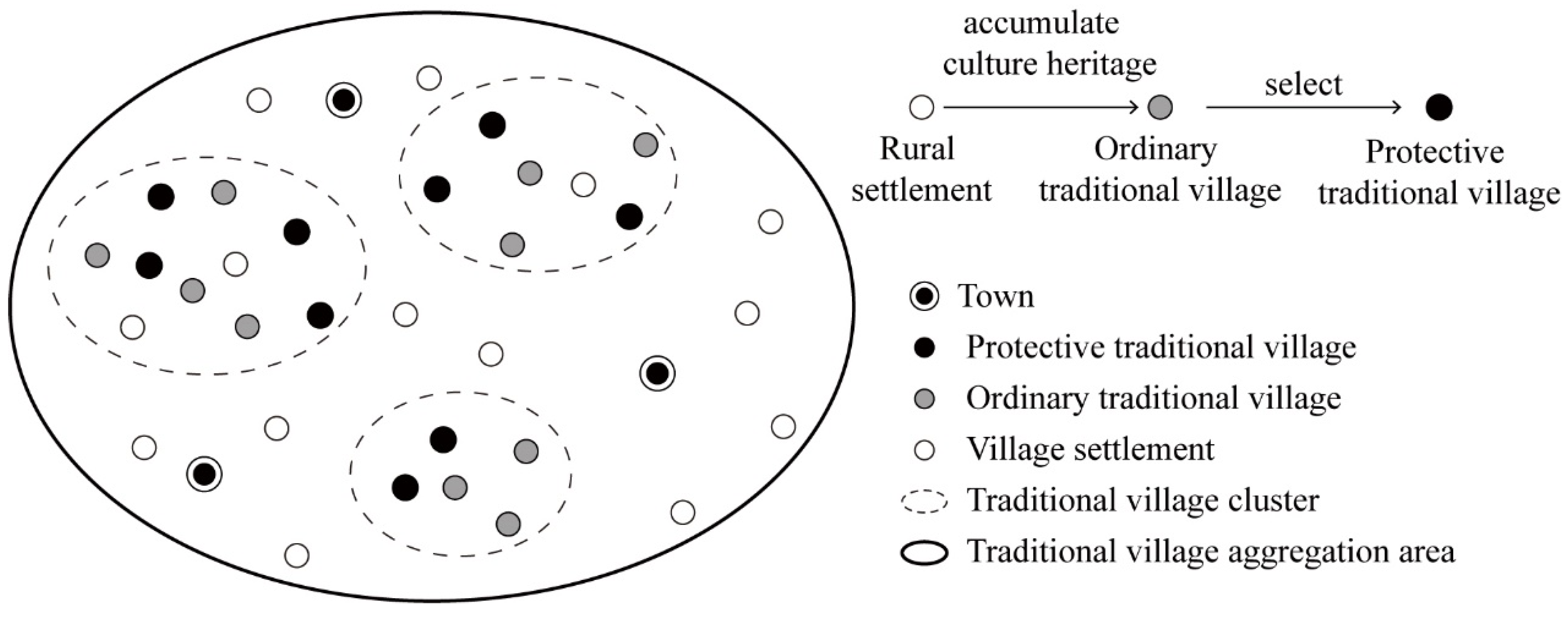
With the continuous evolution of traditional village protection, the protection scope continues to expand, forming a relatively complete protection rating system of “rural settlements–traditional village clusters–traditional village aggregation areas”. At the spatial level of individual rural settlement, widely distributed rural settlements include two types: (1) villages with rich historical and cultural resources and protection value, and (2) other villages. Among them, villages with protection value can be selected in the government’s protection lists. However, some villages may not be included, either because they failed to meet the selection criteria or because they may not have participated at all. In this paper, the former type in the protection lists is called a “protective traditional village”, while a member of the latter type is called a “ordinary traditional village”. Together they form traditional villages. Traditional villages with relatively dense spatial distribution and close socioeconomic and cultural connections are called “traditional village clusters”. However, there may be other rural settlements, natural and cultural resources (scenic spots), and various connecting channels (water systems, roads), etc., within and between traditional village clusters (see
Figure 1). Therefore, the traditional village aggregation area defined in this paper represents a continuously distributed geographical space with traditional village clusters at the core, which includes traditional villages and other rural settlements, natural and cultural resources, as well as connection channels between villages. The rural area composed of these elements is the spatial carrier of regional cultural landscape and the important protection object of Chinese traditional village clusters.
However, the protection of traditional village clusters is faced with some practical and theoretical difficulties. For a long time, protection work has been carried out around historical buildings and individual villages. The lack of support for regional protection policies and measures makes it difficult to quickly clarify the core content of protection work. Furthermore, there are no corresponding updates and adjustments to specific protection measures and research into the protection of traditional village clusters is also relatively scarce, which makes it difficult to provide theoretical and technical support for practice. Secondly, the spatial distribution of these protective traditional villages, such as the CTVs in China, is relatively dispersed from a microscopic perspective. These problems make it difficult for local governments to effectively protect such agglomeration areas, which may eventually turn the cluster protection work into a “collection” of individual village protection projects.
Therefore, when identifying spatial agglomeration areas of traditional villages, moderately increasing the spatial granularity of village samples can accurately reflect the actual spatial distribution of villages, thus improving the accuracy of spatial description in spatial agglomeration analysis.
2.2. Literature Review
The term “Cultural landscape” was proposed in 1992 by the World Heritage Committee at the Convention Concerning the Protection of the World Cultural and Natural Heritage. It emphasized the existence and continuity of the connections between human beings and the natural and living environment, as well as the interconnections between the built environment where humans live and various daily production and living activities [
14]. In 2011, the UNESCO General Assembly further proposed the concept of the “Historic Urban Landscape (HUL)”. The HUL is a way of observing and understanding cities and their urban composition, which conceives cities as spatial, temporal, and experiential constructions of natural, cultural, and socioeconomic processes [
15], and its central idea suggests that historical cities (towns) are the result of “historic layering”. As the core of HUL, “historic layering” emphasizes the dynamic assessment of the attributes of historical heritage with respect to the particular spatial and temporal context [
16]. Moreover, recent studies have underlined the integration of materials and humans in rural areas, indicating that the new materialism may contribute to the revitalization of rural space. The restoration of traditional rural housing is a process of interaction between traditional materiality and human life [
17].
Similar to the city, the rural historical landscape is another major type of human settlement and the result of “historic layering”. A particularly noteworthy example is the traditional village, a type of rural settlement with a long history and rich historical and cultural elements which are preserved to this day. Consequently, their current spatial attributes are the result of various social, economic, and geographical factors in different historical periods [
18,
19]. In the age of agricultural civilization, most humans passively adapted to and relied on nature, and the location selection and spatial distribution of rural settlements were mainly affected by the natural geographical environment. With the rapid improvement of productivity, rural development is less limited to geography. The development of road, water and other transportation has strengthened the connection between different villages and towns. Today, the development of information technology such as the internet has further weakened the restrictions of physical geography. The flow relying on information technology (e.g., information flow and capital flow), together with that relying on basic transportation facilities (e.g., people flow and logistics), have jointly promoted the exchange and coordinated development of elements within the village system as well as between urban and rural areas [
20]. Therefore, on the one hand, the emergence and development of villages are affected by the natural geographical environment and regional socioeconomic development in a certain historical period. On the other hand, individual villages form a regional rural settlement system through transportation, economy, culture, etc., and further form a regional cultural landscape with the spatiotemporal historic layering of various elements.
2.2.1. The Spatial Distribution of Traditional Villages
Research on the spatial distribution of traditional villages has mainly focused on the macro scale, involving the application of geographic information technology and quantitative analysis to reveal the spatial distribution characteristics and influencing factors of traditional villages in areas of different spatial scales. The scale of these studies is classified according to administrative regions, including national scale, inter-provincial regional scale, etc. [
1,
21,
22]. In the meantime, relevant studies have also analyzed cross-administrative geographical units, such as human geographical units divided by cultural attributes and watershed units divided by watersheds, etc. From the perspective of historic layering, the spatial pattern of traditional villages is the result of temporal and spatial layering, along with the combined effects of natural geographical factors and socioeconomic factors.
Specifically, influencing factors mainly include natural geographical factors and socioeconomic factors. For the former ones, in the early stage of the formation of traditional villages, due to basic survival needs such as life safety and agricultural production, regional natural and geographical conditions such as terrain and water systems were the main influencing factors for site selection. Topographical conditions such as altitude, slope and aspect determined the suitability of buildings in the area. On the one hand, overly high altitude and excessive slope would affect the mode and efficiency of agricultural production; on the other hand, such conditions could easily lead to geological disasters, which go against people’s basic safety needs [
23]. In the river basins of southeast China, for example, the distribution of traditional villages presents the characteristics of “more mountainous areas but less coastal areas”, with most villages distributed in the middle and upper reaches [
24]. The impact of the water system on villages is also multifaceted. On the one hand, being “near-water” will improve water availability for living and production [
25]; on the other hand, being “far away from the water” will improve the disaster prevention capacity of the village.
On the other hand, in the process of the development of traditional villages, the ancient land transportation system was not systematic due to some factors such as geological constraints. Therefore, in the early stage of development, water transportation was the primary means of transportation between traditional villages and the outside world. Water transportation was advantageous because of its low transportation cost and high efficiency. The villages along shipping lanes had convenient business contacts, which promoted economic and cultural exchanges between the villages. At the same time, it also attracted the gathering of migrants, thereby promoting the prosperity and development of the villages [
26]. Extant studies have shown that the distribution of traditional villages has a spatial correlation with the ancient transportation routes, such as post roads and ancient roads [
27]. Since the advent of modern times, the gradual improvement of modern road traffic has improved the accessibility and connectivity of the village, but it has also made the village vulnerable to the urbanization of surrounding cities. However, some villages far from urban areas have survived [
28]. The impact of economic progress on the development of traditional villages varies depending on temporal and spatial contexts, and there may be agglomeration areas of traditional villages in both economically developed and economically underdeveloped areas. However, in the period when people’s awareness of historical and cultural protection was not strong and relevant policies and regulations were not perfect, village construction may have ignored its historical value, thus causing irreversible damage and making “traditional villages” become a scarce resource today [
29]. Nonetheless, with the improvement of protection awareness and relevant government policies, socioeconomic development can also provide the financial guarantee as well as talent pool for the development and construction of villages and the protection of historical culture.
It can be seen that the location and spatial layout of Chinese traditional villages are closely related to various natural and geographical elements and are also affected by social and economic development. At the same time, nonspatial socioeconomic factors cannot last for a long time in the process of spatiotemporal layering, but their influence will gradually be transformed into geographical features, that is, it goes through a process of “spatial translation”. For example, the relationship between rural settlements, ancient post roads, and towns is not just a simple spatial relationship, but a comprehensive reflection of the continuous layering of social and economic development over a long period of time in the past.
2.2.2. Protection of Traditional Villages
Relevant research has mainly included rural tourism, rural landscape, traditional rural buildings, and so on, focusing on the conservation and development of individual traditional villages or cultural heritage from a microscopic perspective [
30,
31,
32]. Jung et al. analyzed the challenge, experience and development strategies of rural landscape protection in Gacheon village in Korea [
33]. Moreover, Li et al. proposed fire safety strategies to protect the wooden historical buildings in Hanazawa village [
34].
The research on cluster protection and regional integration of traditional villages or historical cultural resources mainly includes two aspects: the construction of theoretical and technical systems and the formulation of protection and development strategies. The former is the basis of formulation protection and development strategies, while the latter is mainly based on quantitative analysis of spatial features and qualitative analysis of historical logic. In terms of system construction, the extant studies have covered the classification schemes of traditional village clusters on different scales. In the macro-spatial dimension, scholars mostly take administrative regions as the basic unit, and classify village clusters qualitatively according to geography, culture, and landscape associations, and propose a multi-spatial topographic classification of “cluster system-cluster-sub cluster”. In addition, some scholars have introduced network analysis methods such as social network analysis and complex network analysis to analyze the internal connections of villages from the microspatial scale, so as to delimit cluster protection areas [
6]. There are also those who have used the minimum cumulative resistance (MCR) model to identify cultural spaces, cultural routes or landscape networks [
35]. With respect to the formulation of protection and development strategies, relevant research has mainly combined the quantitative analysis of spatial characteristics and qualitative deduction of the historical evolution process to propose cluster protection strategies comprehensively. The cluster protection strategy mainly includes the formulation of the overall spatial protection scheme, the collaborative protection and utilization of multiple spatial levels, and the formation of protection strategies of different classification categories [
36,
37,
38,
39]. For the protection of intangible culture, some studies have proposed protection measures for the cultural morphological characteristics of the traditional village from the aspects of internalized village daily life and external geographical and cultural connections [
40]. To date, most studies mainly take protective traditional villages as samples, ignoring the widespread and huge number of ordinary traditional villages, and such neglect cannot fully reflect the spatial distribution characteristics of traditional villages. Meanwhile, most studies focus on the villages themselves, and less attention is paid to the connection between villages in the traditional village cluster area and the surrounding natural, cultural, and geographical environment.
3. Materials and Methods
3.1. Study Area
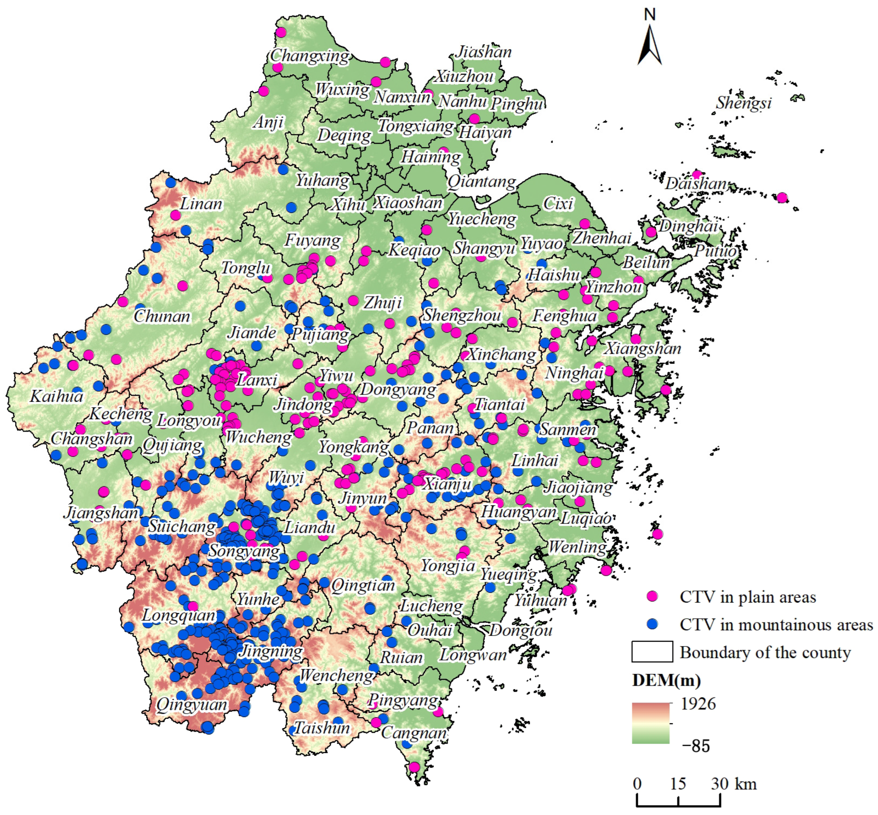
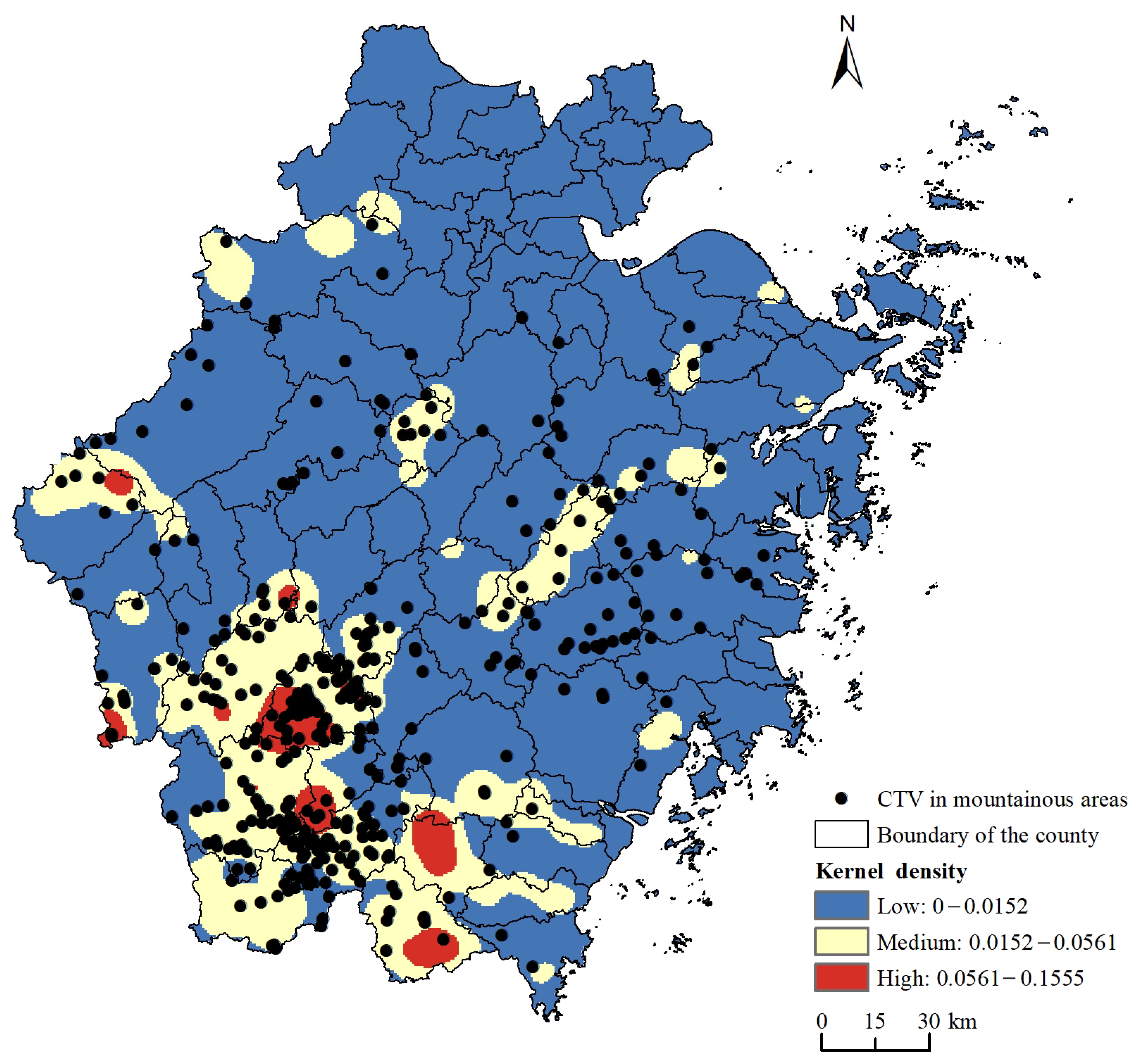
Zhejiang province is located on the southeast coast of China, with profound historical and cultural heritage and rich natural landscape resources. Among the five batches of Chinese traditional villages, 636 villages in Zhejiang province were selected, accounting for 9.3% of the national total. Zhejiang province is high in the southwest, low in the northeast, and rich in water resources. It has been found that the traditional villages in Zhejiang province are distributed in the southern mountainous areas, while they are concentrated in the central low mountains, hills and basins (
Figure 2). In the era of war, people in the central plains, southern Fujian and other places moved to the mountains to escape the war, and lived a reclusive life. They developed a geomantic culture which guides the construction of villages, a cultivation culture which promotes humanistic ethics, a clan culture that emphasizes blood relationships, and a folk culture that embraces ethnic identity. The introduction of population, technology and culture has laid the foundation for historical and cultural accumulation in the hilly areas of Zhejiang. In addition, the relatively secluded geography protected the village from outside interference, thus better preserving its historical characteristics. This provides a prerequisite for preserving the history and culture of the village and the clusters. Therefore, this study will take the hilly regions of Zhejiang province as the study area.
3.2. Identification of Traditional Village Aggregation Areas
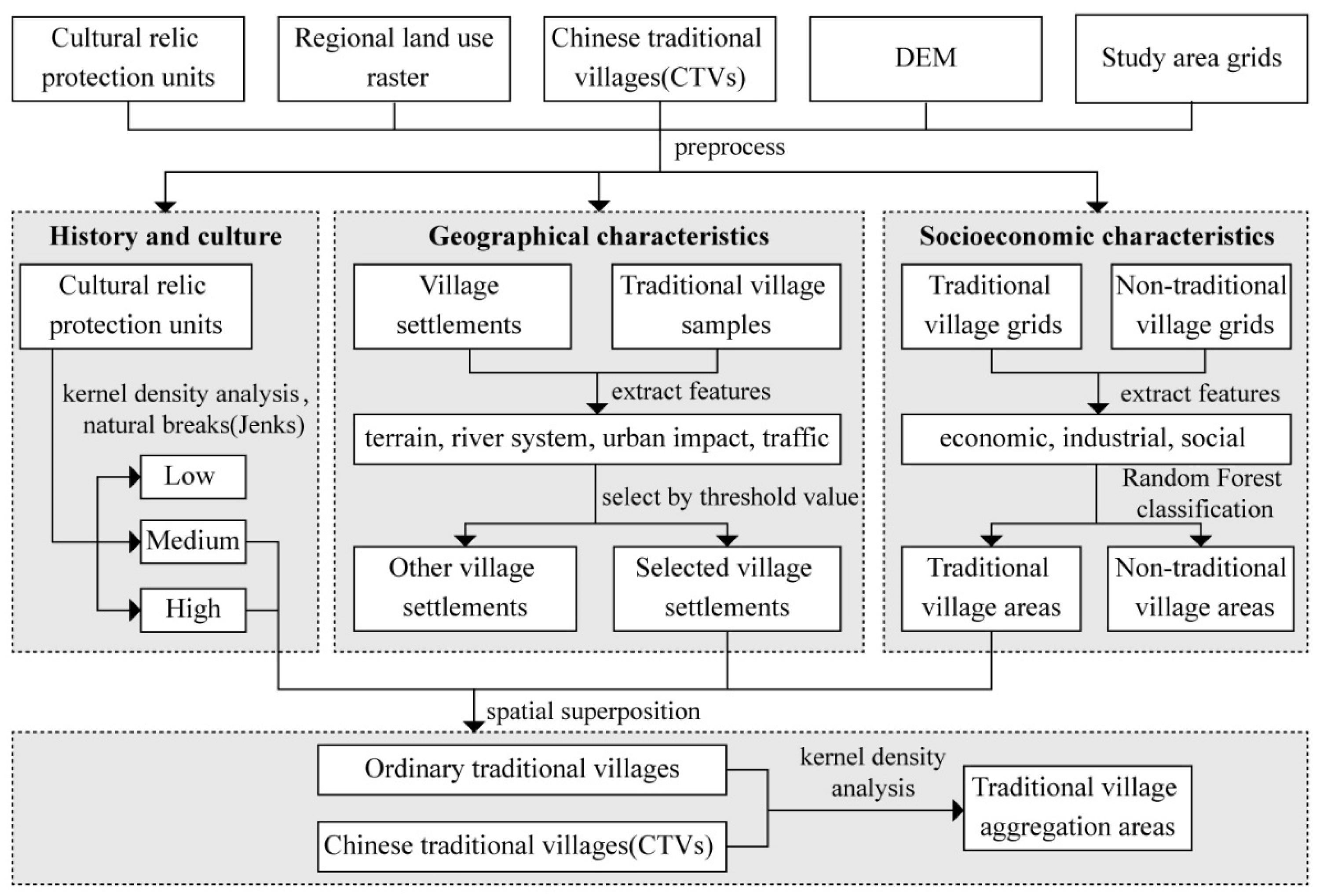
This study sought to analyze and identify the traditional village aggregation areas from three dimensions: history and culture, geographical characteristics, and socioeconomic characteristics.
For historical culture, the results of kernel density analysis of cultural relic protection units were classified into low, medium and high levels based on natural breaks (Jenks), so as to characterize the concentration degree of cultural elements. Kernel density analysis calculates the density of the surrounding continuous regions, and the formula is as follows:
In the formula, f(x) is the kernel density estimate at x; n is the number of point elements; h is the bandwidth (search radius, and h > 0); k () represents the kernel function; and x − xi represents the distance from the element point to the core point.
For geographical characteristics, the geospatial features of all traditional village samples and village settlements to be identified were first extracted. Then, the threshold value was set according to the distribution rule of each feature value of traditional village samples, and the village settlements identified as qualifying were selected as traditional village settlements.
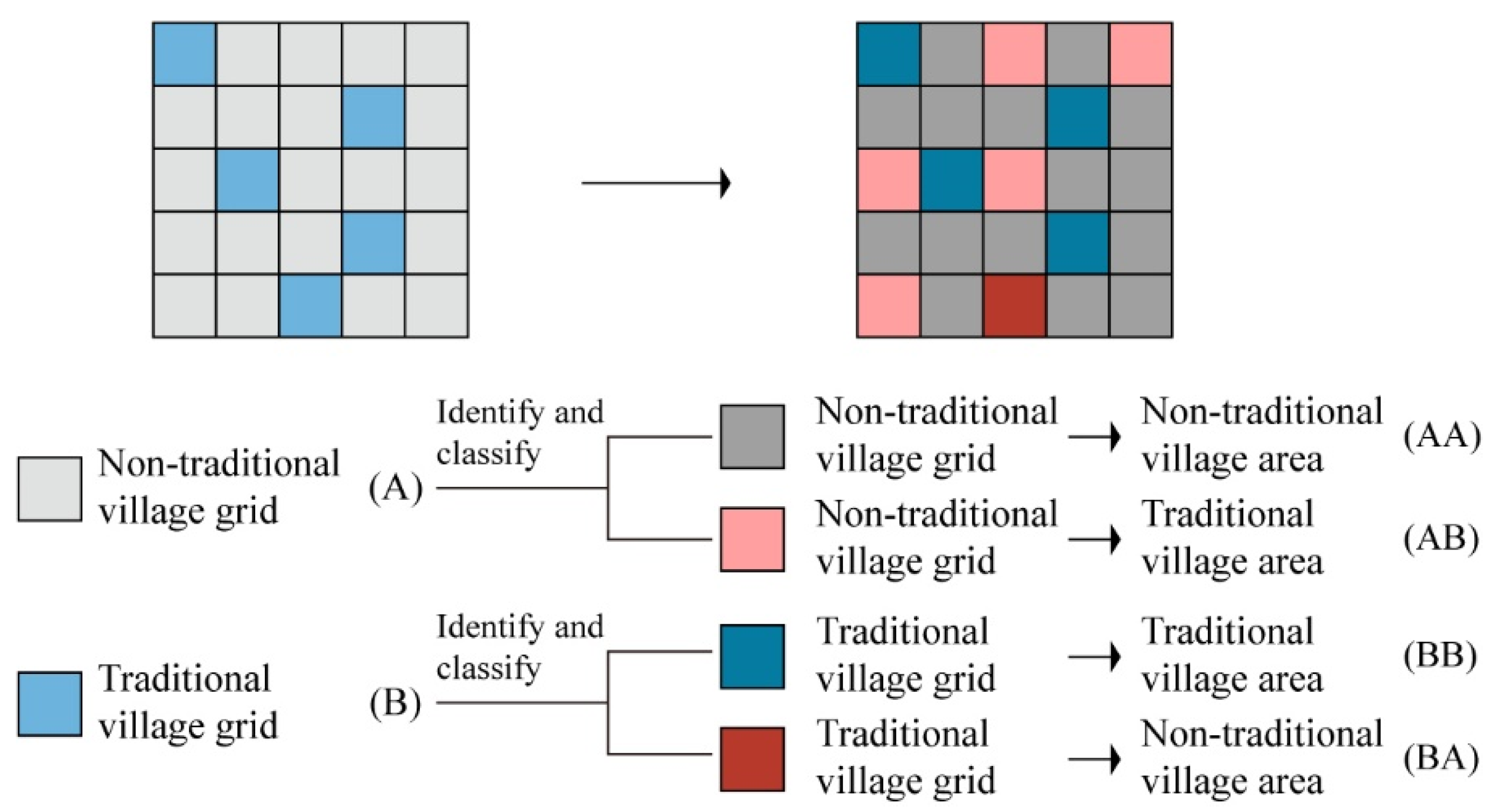
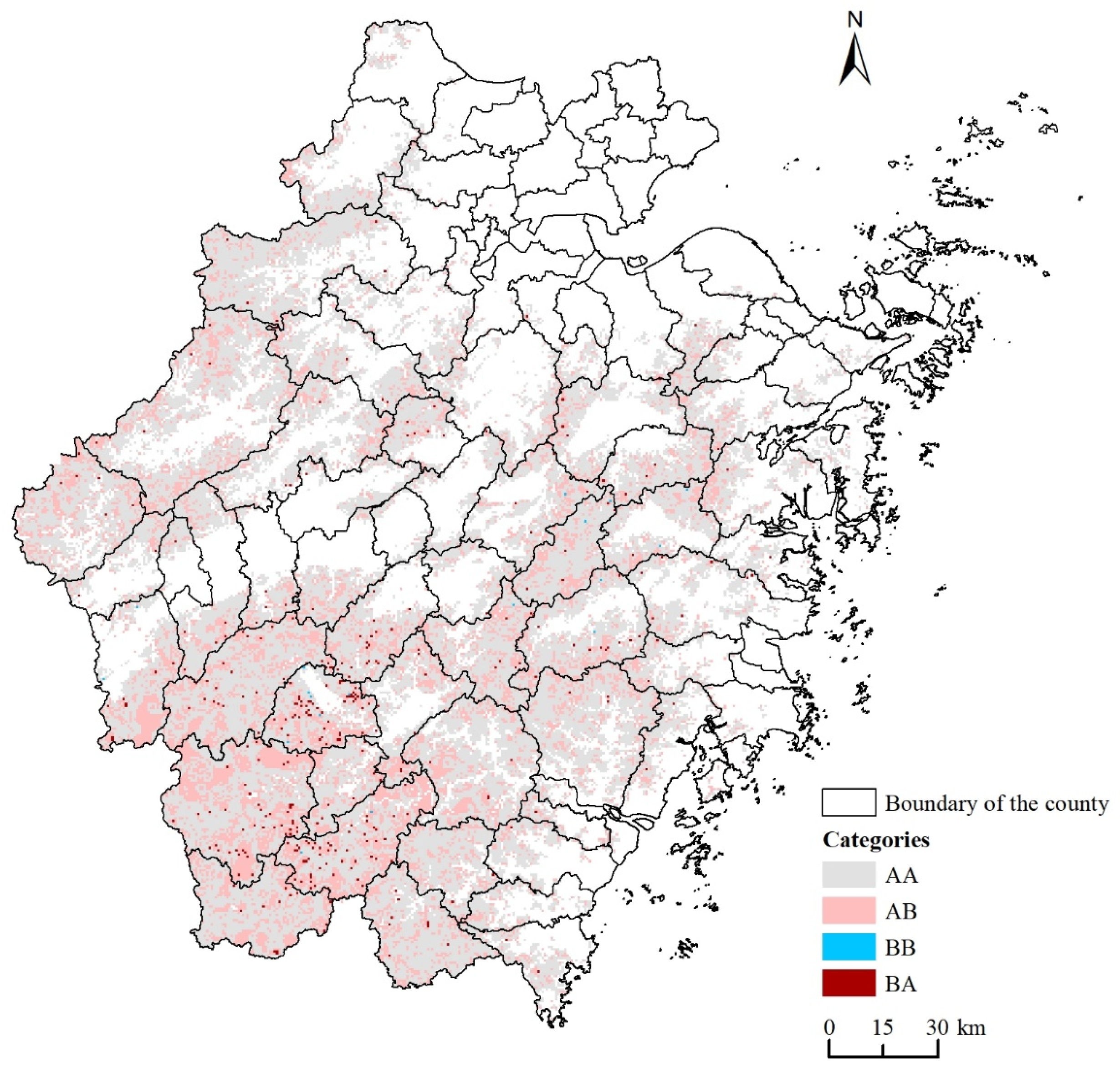
For socioeconomic characteristics, the research area was first divided into a traditional village grid and a nontraditional village grid. The socioeconomic characteristics of each grid were extracted, and a random forest algorithm was used to divide the grids into traditional village areas and nontraditional village areas (
Figure 3). Random forest is an integrated learning algorithm, which can obtain the final predicted classification results by predicting and voting on multiple decision trees. If the recall rate of traditional village grids in the classification results is high (BB/(BB + BA), e.g., more than 95%), it can be assumed that the errors in the overall classification results are mainly generated by the nontraditional village grids (A), while the grids classified as traditional village areas (AB) can be considered as the areas with potential conservation value.
The screening results of the geographical and socioeconomic characteristics were spatially overlaid to select general traditional villages located in areas with medium and high cultural element enrichment. Combined with CTVs, appropriate search radii were set, and the traditional village aggregation areas were identified by kernel density analysis. (
Table 1,
Figure 4).
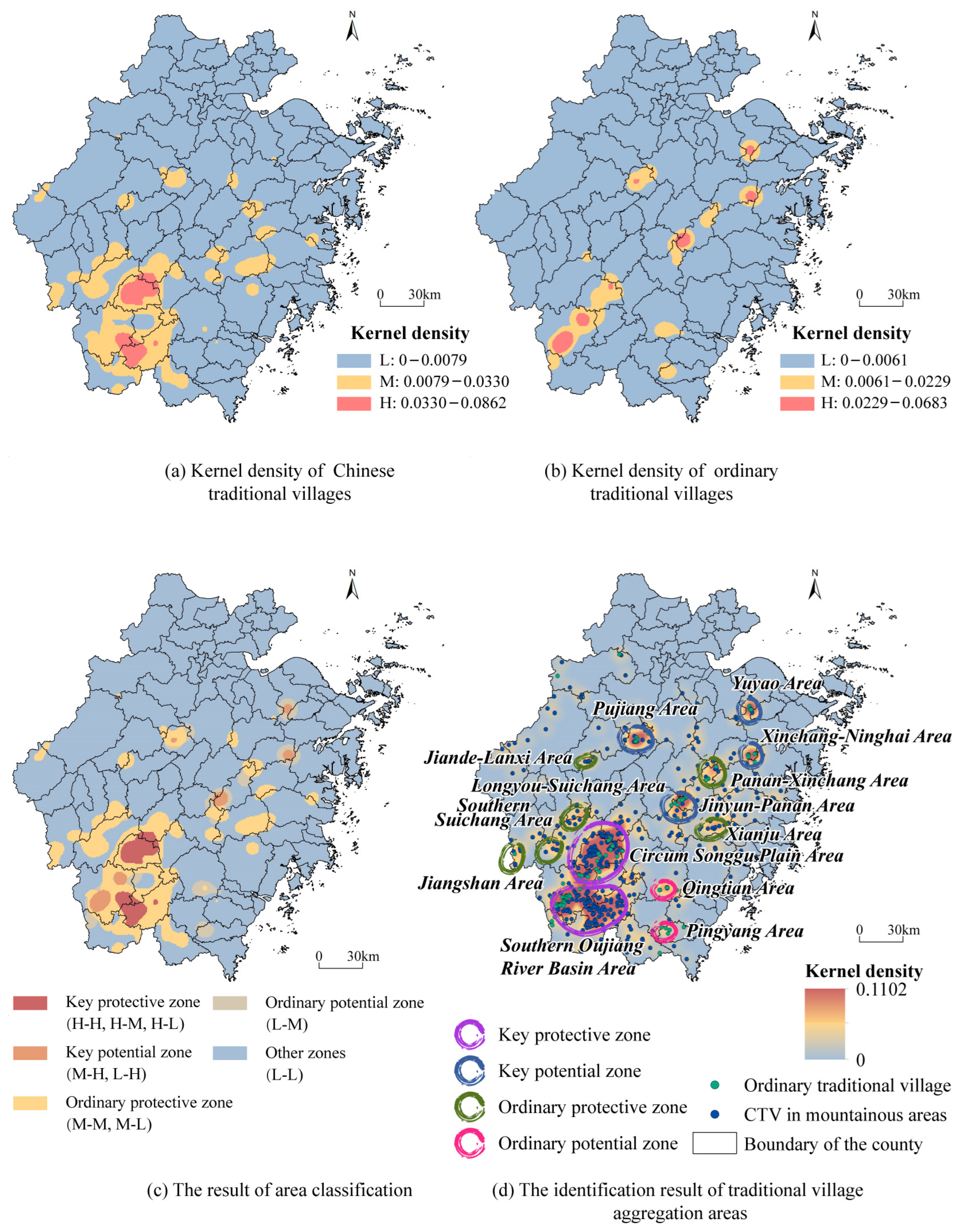
Finally, the analysis results of historical culture, geographical transportation, and socioeconomic development were spatially superimposed. Ordinary traditional villages were screened out, which together with the listed traditional villages constituted the analysis sample of traditional villages. The search radius was set to 15 km, and the kernel density analysis was conducted on the traditional village samples. The kernel density calculation results were reclassified into low (L), medium (M), and high (H) levels based on the natural discontinuity classification method (Jenks). Then, the traditional village clusters were identified. Among them, the advantages and disadvantages of the existing basic protection conditions in the region were pointed out according to the identification results of protected village clusters, and the future development potential of this area was predicted according to the identification results of general traditional village clusters. Based on the spatial superposition of the above two types of identification results, considering the basic protection conditions and development potential, the spatial types were further divided into five types: Key protective zone (H-H, H-M, H-L), key potential zone (M-H, L-H), ordinary protective zone (M-M, M-L), ordinary potential zone (L-M), and others.
3.3. Data Sources and Preprocessing
The data used in this paper mainly include statistics and spatial data (
Table 2).
Statistical data refer to CTVs and cultural relic protection units. Through the online list of Chinese traditional villages published by the central government, we obtained a list of all CTVs in Zhejiang province. Similarly, the list of cultural relic protection units was accessed from the official websites of the Zhejiang Provincial Bureau of Cultural Relics. In order to spatialize the above statistical data for the proposed model, their geographical points were obtained by using Amap for geospatial positioning. Furthermore, screening the village samples was essential. Based on previous research, 200 m above sea level was taken as the boundary between the plains and the mountain hills. Thus, CTVs with an elevation greater than 200 m were selected as research samples (413 CTVs in mountainous areas were selected). In addition, the rural construction lands in land use data with elevations of more than 200 m were selected as the village settlement samples. On this basis, we marked the spatial grids within CTV samples as the traditional village grids and set the other grids as nontraditional village grids. Furthermore, the points of cultural relic protection units with an elevation of more than 200 m and located in nonurban areas were selected as samples.
Spatial data refer to the digital elevation model (DEM), water system, road, and land use data. DEM data with a resolution of 30m came from EarthData (
https://earthdata.nasa.gov/ (accessed on 10 March 2021)). Both the water system data and road data contain current data and historic data. Current water system data and road data were soured from the National Catalogue Service for Geographic Information (
https://www.webmap.cn/commres.do?method=result100W (accessed on 14 April 2021)). The historic water system data from the Qing dynasty and the road data from the Ming dynasty were obtained from Harvard Dataverse (
https://dataverse.harvard.edu/dataverse/harvard (accessed on 14 May 2021)). The road data from the Tang and Song dynasties were artificially spatialized through ArcGIS 10.5 based on the “History of Ancient Road Traffic in Zhejiang” [
41]. Finally, land use data with a resolution of 30 m (2015) were obtained from the Resource and Environment Science and Data Center, PRC, and Points of Interest (POI) data were from Amap. This study mainly used eight types of POI data which were closely related to traditional villages, including catering services, shopping services, life services, corporate enterprises, accommodation services, education and cultural services, sports and leisure services, and medical and health services.
4. Results
4.1. Spatial Identification Based on Traditional Villages’ Features
4.1.1. Historic Culture Feature
According to Jenks’ natural breaks classification, the spatial kernel density analysis results of the cultural relics protection units were divided into three levels (i.e., low, medium, and high), and the areas with relatively concentrated historical and cultural elements were identified. On the macro scale, there is a significant correlation between the spatial agglomeration of cultural relics protection units and the spatial distribution of CTVs in mountainous areas, both of which are mainly concentrated in Lishui, a mountainous area in the southwest of Zhejiang province. In other areas, the spatial agglomeration is mismatched, as shown in
Figure 5. For example, Wencheng county and Taishun county have remarkable spatial agglomeration of cultural relics protection units, but the number of CTVs in the above-mentioned two counties is relatively small. In contrast, there are a large number of CTVs in Xianju county and Tiantai county along the Kuocang mountains, but the number of cultural protection units in this area is less. It can be seen that cultural relics protection units are indeed an important part of the selection system of traditional villages and have spatial correlations with some Chinese traditional villages; however, they are not decisive in the spatial distribution.
4.1.2. Geographical Features
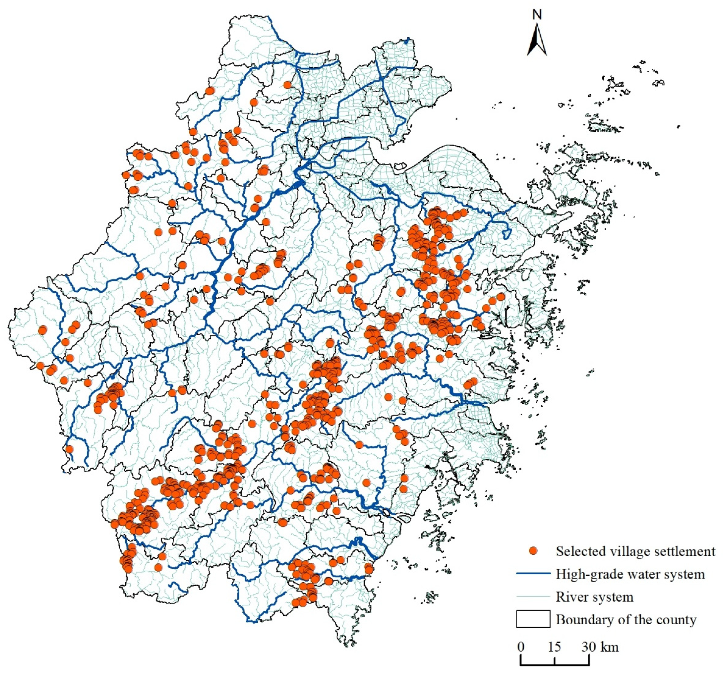
Taking 413 CTVs in mountainous areas as samples, the ArcGIS10.5 software was employed to analyze the spatial characteristics of topography, river systems, urban impact, road traffic and other specific indicators. Based on the correlation between each specific indicator and the influence of traditional villages, the threshold value of geospatial features was set in a way that was conducive to the preservation of traditional villages. The mean value μ and standard deviation σ were used to determine the screening thresholds of each geospatial feature, where the distance range to the nearest town is (μ − σ, μ + σ), and the range of other indicators is (0, μ + σ). The thresholds of each indicator were: the elevation is less than 823.40 m; the shortest distance to the water network is less than 2.42 km; the distance to the nearest high-grade water system is less than 14.23 km; the distance to the nearest ancient post road is less than 36.27 km; the distance to the nearest national road is less than 34.28 km; the distance to the nearest provincial road is less than 15.65 km; and the distance to the nearest town is greater than 5.26 km and less than 19.89 km. According to the thresholds of the above seven indicators, the rural settlements in hilly areas of Zhejiang province were screened, and all the village settlements which met the above thresholds were selected.
As shown in
Figure 6, based on geospatial features, the village settlements with identified conservation value are mainly distributed in the south and east hilly regions of Zhejiang province. Among them, the selected villages are concentrated from Tiantai mountain in eastern Zhejiang province, to Kuocang mountain in central Zhejiang province, and then to Donggong mountain in southern Zhejiang province. In comparison, the selected villages in the Tianmu mountains of northern Zhejiang province were relatively sparse and scattered.
4.1.3. Socioeconomic Features
Due to the lack of statistical data, such as GDP per capita, which can directly reflect the socioeconomic level of the village, this study will use POI information to represent the socioeconomic characteristics of traditional villages. POI information was quantified from two aspects: one was to calculate the shortest distance from the grid center point to each POI; the other was to analyze the kernel density of various POIs in terms of quantity and scale, where the search radius was set to 10km, and to assign a density value to each mesh. Then, a random forest model was constructed, with the grid category (traditional village area/nontraditional village area) as the classification target, and the nearest distance and kernel density values of each POI as characteristic variables. By adjusting the model parameters, the recall rate of the traditional village grid eventually reached 95.31%, and the overall accuracy rate of the model reached 74.53%. Errors in the overall classification results mainly came from the nontraditional village grids, and the grids classified as traditional village areas could be considered areas with potential protection value (
Figure 7).
4.2. Spatial Distribution of Traditional Village Aggregation Areas
Based on the identification results of the above-mentioned historical cultural, geographical, and socioeconomic features, the 14 main traditional village agglomeration areas in Zhejiang province were obtained through integrated identification. According to the quantity and spatial concentration of state-level traditional villages and general traditional villages in the above-mentioned areas, they can be divided into four categories (
Figure 8):
Two key protection zones, mainly in the area around Songgu plain and the southern area of the Oujiang river basin. Both areas are located in the upper reaches of the Oujiang river basin, where CTVs are highly concentrated. Individual traditional villages have been systematically protected in this type of area, with a very solid foundation of cluster protection and development. Among them, the Around Songgu plain reserve is located in Songyang county, and the southern area of the Oujiang river basin includes three county-level administrative regions, namely Qingyuan, Jingning and Longquan.
Four key potential zones, mainly in the Pujiang area, Yuyao area, Xinchang-Ninghai area and Jinyun-Pan’an area. The four areas are mainly distributed in the central and eastern regions of Zhejiang province. The number of traditional villages in each area is large, but the number of CTVs is small, and the proportion of ordinary traditional villages is relatively high. Therefore, compared with key protection zones, relatively less protection and utilization work has been carried out in these areas. At the same time, there are more potential high-quality resources to be developed and utilized.
Six ordinary protective zones, mainly in the Jiande-Lanxi area, Longyou-Suichang area, southern Suichang area, Jiangshan area, Pan’an-Xinchang area, and Xianju area. All of these are small areas dominated by a few CTVs. Meanwhile, there is a lack or a small number of ordinary traditional villages. Limited by the scale effect and the requirements of village protection policies, the region focuses more on protection rather than the potential resources that can be developed and utilized.
Two ordinary potential zones, namely the Qingtian area and Pingyang area, which are mainly concentrated in the southeastern hilly area of Zhejiang province. Most of these areas are composed of ordinary traditional villages with small spatial agglomeration area. It also lacks the support and guidance of the high-level protection resources such as those enjoyed by national CTVs.
5. Discussion
5.1. Comparision and Contribution of Spatial Identification Method
The conservation of traditional village aggregation areas not only contributes to the preservation of village cultural heritage, but also promotes the sustainable development of the historic cultural landscape by integrating the surrounding natural environment and historical heritage [
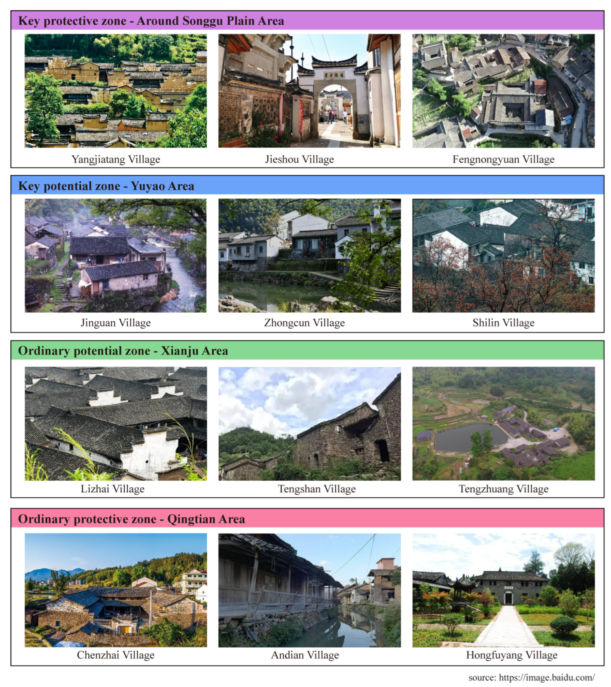
42]. The proposed identification method of traditional village aggregation areas is based on a comprehensive consideration of cultural protection, geographical characteristics and socioeconomic characteristics. However, the “historic layering” of different indicators in different types of identified areas shows significant differences in geographical characteristics, which reflects the different effects of various indicators. The representative villages of four aggregation area types in Zhejiang province are shown in
Figure 9. This also indicates that the identification results of this method are accurate and have the ability to guide local rural development practices.
Previous studies have used historical and cultural resources, such as traditional villages and cultural heritage protection units, to construct transregional landscape networks or cultural heritage tourism corridor networks. This study innovatively considers a broader cultural landscape by combining both traditional villages and their surrounding environment. Firstly, we circumvented the identified sample bias by expanding the traditional village sample, which contains protective and ordinary traditional villages, so as to attenuate the uneven spatial distribution of protective traditional villages caused by the application willingness of local governments and declaration screening. Secondly, this study constructs identification indicators which incorporate elements of the surrounding environment, such as the historical water systems and historical roads, from the perspective of historical layering, and analyzes those factors’ spatial relationships with the spatial distribution of traditional villages. Based on the optimization of the above two approaches, the applicability of the proposed identification method and the spatial accuracy of the identification results have been significantly improved. For example, Wu et al. pointed out 15 traditional village clusters according to the distribution of protective traditional villages in Zhejiang Province [
43]. In terms of the hilly regions, even though most results of the two studies are consistent, they are different in the following two aspects. First, the spatial extent fineness of the identified areas was optimized. The spatial range of results identified in this study is more focused compared to Wu’s research, which could provide more targeted guidance for the conservation and utilization of traditional villages. Next, the classification number and type characteristics of spatial identification results were more abundant. For example, the Yuyao Area, Qingtian Area, and Pingyang Area have been identified as potential zones in this study due to the spatial aggregation of ordinary traditional villages. However, Wu et al. ignored the potential protection value of other regions because they only focused on the traditional villages that have been listed in the government’s protection policy.
5.2. Classification Characteristics of Traditional Village Aggregation Areas
For the aggregation areas which include a large number of traditional villages, most of them have historic internal communication channels for human and logistic flows, and are a little far from the big cities. Those ancient transportation routes, both by land and by water, can help surrounding villages to have a strong external economic base in historic periods. Meanwhile, staying away from big cities can minimize the impact of rapid urbanization on the villages. Take the key protection zone around Songgu Plain as an example; this area is the most representative gathering area of traditional villages in Zhejiang province, with a total of 75 CTVs in five national batches. The traditional villages in Songyang county retain their unique architectural features, folk customs, and village layouts; therefore, they are an important means to display the regional Hakka culture, farming–reading tradition, Chinese Fengshui, and clan culture. The Songyin river in this area is one of the main tributaries of the Oujiang river upstream, and it is also the main waterway of Songyang county. The villages along the river where the wharf is located are able to prosper and develop, and some of them have been selected as CTVs, such as Jieshou village (Jieshou wharf), Nanzhou village (Nanzhou wharf), Fengnongyuan village (Fengnongyuan wharf), etc. The key potential area Yuyao is located around the Siming mountain scenic area, surrounded by CTVs such as Jinguan village, Zhongcun village, and Shilin village. Some other rural settlements in the region also retain ancient dwellings and ancestral halls and temples, as well as ancient trees and bridges, such as Xiaoyun village and Shimen village. There are still relatively complete ancient roads in this area, which is an important traffic channel from central Zhejiang to eastern Zhejiang. This makes it possible to establish a spatial connection between various traditional villages and scenic spots and promote the formation of rural systems in this area.
On the other hand, the aggregation areas that have dispersed traditional villages, such as the ordinary protective zones and potential zones in this study, are mostly located in the areas with difficult traffic conditions and relatively strong nonagriculture income. Due to the scattered spatial distribution of rural settlements and high transportation costs, the villages have weak spatial connections and functional linkage. Loose village systems lead to great differences in village development and uneven basic conditions for protection and utilization. For example, there are CTVs such as Chenzhai village and Andian village in the Qingtian potential zone, as well as the ancient buildings and bridges in the surrounding Fushan village and Hongfuyang village, all of which have traditional commercial streets and ancient buildings from the Ming and Qing dynasties with high values for protection and utilization. However, this area is surrounded by continuous undulating mountains and rivers, resulting in journeys between villages which may exceed one hour without modern transportation. Furthermore, Qingtian county and Pingyang county have had relatively rapid economic development in recent decades, largely due to the fact that there are many residents from overseas and villagers there generally have high incomes. They may have more demands for new building construction and living space expansion, and lack the awareness and willingness to protect traditional villages.
6. Conclusions
Traditional villages are a precious form of cultural heritage, and their evolution is shaped by the natural environment and historical culture of a certain area. The village clusters, along with their surrounding natural and human resources, constitute the rural, regional cultural landscape due to its geographic proximity and close economic and cultural connections. This paper explicates the concept of the traditional village aggregation area, and proposes the technical framework of ordinary traditional village identification and traditional village aggregation area identification. It suggests that the protection and utilization of traditional village clusters should not be limited to “protective traditional villages”. In addition, the identification of ordinary traditional villages and the overall protection of the regional cultural landscape need to be strengthened. This paper emphasizes that the spatial distribution of traditional villages is the result of the spatiotemporal historic layering under the comprehensive influence of various factors, such as natural geography, social economy, and culture in the development process of villages. Nonspatial factors (e.g., economic factors), although not sustainably preserved, can influence the formation of some groups and specific geographical features through “spatial translation”. On this basis, this paper selected eight indicators from three dimensions (i.e., natural geographical features, socioeconomic features, and historical and cultural protection) to construct an index system of traditional village characteristics. Taking protective traditional villages as samples, the index values to identify ordinary traditional villages are calculated through comprehensive screening, which together with the protective villages constitute the sample of traditional villages. Based on the above results, this paper identified 14 traditional village cluster areas in hilly areas of Zhejiang province, and divided them into two key protective zones, four key potential zones, six ordinary protective zones, and two ordinary potential zones according to the basic conditions of regional protection and regional development potential. The identification of these aggregation areas overcomes the limitation of administrative boundaries, avoids the waste of protection resources caused by excessive protection scope, and effectively reduces the burden of basic investigation work in villages. Therefore, the identification framework and those findings are of great significance to the protection of traditional village clusters in hilly areas of Zhejiang province.
Compared with the pilot counties for the protection and utilization of traditional village clusters in China, the traditional village aggregation areas identified in this paper achieve more accurate spatial identification. Compared to international rural cultural landscape preservation studies, this paper, by identifying cultural conservation units with villages as the primary spatial carriers from historic layering theory, provides more practical guidance for subsequent rural conservation planning or relevant policy implementation. Nonetheless, there are some limitations to the study. First, indicators affecting the spatial distribution of traditional villages are selected from a macro perspective, and lacking those with local characteristics has made it difficult to guide the identification of aggregation areas at the meso-spatial scale. There is also a lack of in-depth exploration of the connections between villages within the aggregation area.
Future research can focus on the following issues: (1) Based on the identification of macro aggregation areas, further explore the spatial distribution pattern of traditional villages by analyzing the corresponding relationships between local cultural attributes, such as traditional housing and physical space. GIS spatial analysis, remote sensing interpretation, machine learning and other technical methods could be used for feature extraction and model training of satellite images, aerial photographs and maps, so as to optimize the accuracy and efficiency of spatial identification of traditional village aggregation areas. (2) Explore the structure of traditional village aggregation areas and their conservation policy guidelines. For the aggregation areas themselves, based on the field research data or big data such as SDK, the network analysis method can be used to conduct in-depth explorations of the village network system within each identification area. The results can provide reference points for the development of hierarchical and categorical conservation strategies of traditional village aggregation areas.
Author Contributions
Conceptualization, M.Z.; data curation, C.S. and Q.C.; formal analysis, C.S. and M.Z.; funding acquisition, Q.C.; investigation, C.S.; methodology, W.G. and M.Z.; project administration, M.Z.; resources, Q.C.; software, W.G.; supervision, Q.C.; validation, C.S.; visualization, C.S.; writing—original draft, C.S. and M.Z.; writing—review and editing, W.G. and M.Z. All authors have read and agreed to the published version of the manuscript.
Funding
This research was funded by Center for Balance Architecture, Zhejiang University.
Data Availability Statement
No new data were created or analyzed in this study. Data sharing is not applicable to this article.
Conflicts of Interest
The authors declare no conflict of interest.
References
- Liu, S.; Ge, J.; Bai, M.; Yao, M.; He, L.; Chen, M. Toward classification-based sustainable revitalization: Assessing the vitality of traditional villages. Land Use Policy 2022, 116, 106060. [Google Scholar] [CrossRef]
- Oikonomopoulou, E.; Delegou, E.T.; Sayas, J.; Moropoulou, A. An innovative approach to the protection of cultural heritage: The case of cultural routes in Chios Island, Greece. J. Archaeol. Sci. Rep. 2017, 14, 742–757. [Google Scholar] [CrossRef]
- Li, H.; Jing, J.; Fan, H.; Li, Y.; Liu, Y.; Ren, J. Identifying cultural heritage corridors for preservation through multidimensional network connectivity analysis—A case study of the ancient Tea-Horse Road in Simao, China. Landsc. Res. 2021, 46, 96–115. [Google Scholar] [CrossRef]
- Arcos-Pumarola, J.; Paquin, A.G.; Sitges, M.H. The use of intangible heritage and creative industries as a tourism asset in the UNESCO creative cities network. Heliyon 2023, 9, e13106. [Google Scholar] [CrossRef]
- Cohen, I.A.; Sofer, M. Integrated rural heritage landscapes: The case of agricultural cooperative settlements and open space in Israel. J. Rural. Stud. 2017, 54, 98–110. [Google Scholar] [CrossRef]
- Li, G.; Hu, W. A network-based approach for landscape integration of traditional settlements: A case study in the Wuling Mountain area, southwestern China. Land Use Policy 2019, 83, 105–112. [Google Scholar] [CrossRef]
- Xin, J.; Yang, J.; Sun, D.; Han, T.; Song, C.; Shi, Z. Seasonal Differences in Land Surface Temperature under Different Land Use/Land Cover Types from the Perspective of Different Climate Zones. Land 2022, 11, 1122. [Google Scholar] [CrossRef]
- Liu, X.; He, J.; Xiong, K.; Liu, S.; He, B.J. Identification of factors affecting public willingness to pay for heat mitigation and adaptation: Evidence from Guangzhou, China. Urban Clim. 2023, 48, 101405. [Google Scholar] [CrossRef]
- Appler, D.; Rumbach, A. Building community resilience through historic preservation. J. Am. Plan. Assoc. 2016, 82, 92–103. [Google Scholar] [CrossRef]
- Zhang, B. Historic urban and rural settlements: A new category towards regional and integral conservation of cultural heritage. Urban Plan. Forum 2015, 6, 5–11. [Google Scholar]
- Dong, W. An initial approach to the establishment of national historic and Cultural spatial system. City Plan. Rev. 2022, 46, 71–78. [Google Scholar]
- Kwon, H. Villagers’ agency in the Intangible Cultural Heritage designation of a Korean village ritual. Int. J. Herit. Stud. 2017, 23, 200–214. [Google Scholar] [CrossRef]
- Yu, H. A vernacular way of “safeguarding” intangible heritage: The fall and rise of rituals in Gouliang Miao village. Int. J. Herit. Stud. 2015, 21, 1016–1035. [Google Scholar] [CrossRef]
- Vos, W.; Meekes, H. Trends in European cultural landscape development: Perspectives for a sustainable future. Landsc. Urban Plan. 1999, 46, 3–14. [Google Scholar] [CrossRef]
- Ginzarly, M.; Houbart, C.; Teller, J. The Historic Urban Landscape approach to urban management: A systematic review. Int. J. Herit. Stud. 2019, 25, 999–1019. [Google Scholar] [CrossRef]
- United Nations Educational, Scientific and Cultural Organization. Recommendation on the historic urban landscape. In Proceedings of the Records of the General Conference 36th Session, Pairs, France, 25 October–10 November 2011. [Google Scholar]
- Paniagua, A. Conceptualizing New Materialism in Geographical Studies of the Rural Realm. Land 2023, 12, 225. [Google Scholar] [CrossRef]
- Chen, X.; Xie, W.; Li, H. The spatial evolution process, characteristics and driving factors of traditional villages from the perspective of the cultural ecosystem: A case study of Chengkan Village. Habitat Int. 2020, 104, 102250. [Google Scholar] [CrossRef]
- Tu, L.; Zhao, P.; Hu, Y.; Zhang, C. Theory of layering cognition and integrated conservation of traditional villages: Introduction of historic urban landscape approach. Urban Dev. Stud. 2021, 28, 92–97. [Google Scholar]
- Castells, M. The Informational City: Information Technology, Economic Restructuring, and the Urban-Regional Process; Basil Blackwell: Oxford, UK, 1989. [Google Scholar]
- Ma, H.D.; Tong, Y. Spatial differentiation of traditional villages using ArcGIS and GeoDa: A case study of Southwest China. Ecol. Inform. 2022, 68, 101416. [Google Scholar] [CrossRef]
- Jin, J.; Yan, H. Analyzing the causes of spatial differentiation of the traditional villages in Gansu Province, western China. J. Geosci. Environ. Prot. 2020, 8, 12–25. [Google Scholar] [CrossRef]
- Xu, Y.; Qiu, X.; Yang, X.; Lu, X.; Chen, G. Disaster risk management models for rural relocation communities of mountainous southwestern China under the stress of geological disasters. Int. J. Disaster Risk Reduct. 2020, 50, 101697. [Google Scholar] [CrossRef]
- Zhang, B.; Chen, Y. Traditional Village Planning under the Theory of Actor Network: A Case Study of Village Planning in the Jingmai Mountain, Pu’er, Yunnan Provinc. J. Landsc. Res. 2021, 13, 29–35. [Google Scholar]
- Hamouda, A.Z.; El-Gharabawy, S.; Fekry, A. Sonar investigation of the old Nubian Villages in the bottom topography of Nasser Lake, Egypt. Egypt. J. Remote Sens. Space Sci. 2023, 26, 207–215. [Google Scholar] [CrossRef]
- Lin, Y. E-urbanism: E-commerce, migration, and the transformation of Taobao villages in urban China. Cities 2019, 91, 202–212. [Google Scholar] [CrossRef]
- Xu, H.; Zhao, G.; Fagerholm, N.; Primdahl, J.; Plieninger, T. Participatory mapping of cultural ecosystem services for landscape corridor planning: A case study of the Silk Roads corridor in Zhangye, China. J. Environ. Manag. 2020, 264, 110458. [Google Scholar] [CrossRef]
- Li, Y.; Fan, P.; Liu, Y. What makes better village development in traditional agricultural areas of China? Evidence from long-term observation of typical villages. Habitat Int. 2019, 83, 111–124. [Google Scholar] [CrossRef]
- Sardaro, R.; La Sala, P.; De Pascale, G.; Faccilongo, N. The conservation of cultural heritage in rural areas: Stakeholder preferences regarding historical rural buildings in Apulia, southern Italy. Land Use Policy 2021, 109, 105662. [Google Scholar] [CrossRef]
- Ciolac, R.; Iancu, T.; Popescu, G.; Adamov, T.; Feher, A.; Stanciu, S. Smart Tourist Village—An Entrepreneurial Necessity for Maramures Rural Area. Sustainability 2022, 14, 8914. [Google Scholar] [CrossRef]
- Dezio, C.; Zhang, C.; Zhang, Y.; Marino, D. The Role of Landscape Design in Cultural Rural Areas. A Didactic Exercise to Experiment a Research-by-Design Process Applied to an Italian UNESCO Wine Site. Architecture 2021, 1, 117–139. [Google Scholar] [CrossRef]
- Parlato, M.C.M.; Valenti, F.; Porto, S.M.C. Sustainable Promotion of Traditional Rural Buildings as Built Heritage Attractions: A Heritage Interpretation Methodology Applied in South Italy. Sustainability 2022, 14, 16206. [Google Scholar] [CrossRef]
- Jung, H.-J.; Ryu, J.-H. Sustaining a Korean Traditional Rural Landscape in the Context of Cultural Landscape. Sustainability 2015, 7, 11213–11239. [Google Scholar] [CrossRef]
- Li, M.; Hasemi, Y.; Nozoe, Y.; Nagasawa, M. Study on strategy for fire safety planning based on local resident cooperation in a preserved historical mountain village in Japan. Int. J. Disaster Risk Reduct. 2021, 56, 102081. [Google Scholar] [CrossRef]
- Chen, Z.; Liu, Y.; Feng, W.; Li, Y.; Li, L. Study on spatial tropism distribution of rural settlements in the Loess Hilly and Gully Region based on natural factors and traffic accessibility. J. Rural Stud. 2022, 93, 441–448. [Google Scholar] [CrossRef]
- Li, Y.; Jia, L.; Wu, W.; Yan, J.; Liu, Y. Urbanization for rural sustainability–Rethinking China’s urbanization strategy. J. Clean. Prod. 2018, 178, 580–586. [Google Scholar] [CrossRef]
- Liu, Y.; Zang, Y.; Yang, Y. China’s rural revitalization and development: Theory, technology and management. J. Geogr. Sci. 2020, 30, 1923–1942. [Google Scholar] [CrossRef]
- Ye, C.; Ma, X.; Gao, Y.; Johnson, L. The lost countryside: Spatial production of rural culture in Tangwan village in Shanghai. Habitat Int. 2020, 98, 102137. [Google Scholar] [CrossRef]
- Katapidi, I. Heritage policy meets community praxis: Widening conservation approaches in the traditional villages of central Greece. J. Rural Stud. 2021, 81, 47–58. [Google Scholar] [CrossRef]
- Li, G.; Jiang, G.; Jiang, C.; Bai, J. Differentiation of spatial morphology of rural settlements from an ethnic cultural perspective on the Northeast Tibetan Plateau, China. Habitat Int. 2018, 79, 1–9. [Google Scholar] [CrossRef]
- Xu, W. History of Ancient Road Traffic in Zhejiang, 1st ed.; Zhejiang Ancient Books Publishing House: Hangzhou, China, 1992; p. 82. [Google Scholar]
- Qin, R.J.; Leung, H.H. Becoming a Traditional Village: Heritage Protection and Livelihood Transformation of a Chinese Village. Sustainability 2021, 13, 2331. [Google Scholar] [CrossRef]
- Wu, L.; Yu, J. Exploration on the Spatial Characteristics and Protection Utilization of Traditional Villages in Zhejiang Province. Urban Dev. Stud. 2021, 28, 32–39. [Google Scholar]
| Disclaimer/Publisher’s Note: The statements, opinions and data contained in all publications are solely those of the individual author(s) and contributor(s) and not of MDPI and/or the editor(s). MDPI and/or the editor(s) disclaim responsibility for any injury to people or property resulting from any ideas, methods, instructions or products referred to in the content. |
© 2023 by the authors. Licensee MDPI, Basel, Switzerland. This article is an open access article distributed under the terms and conditions of the Creative Commons Attribution (CC BY) license (https://creativecommons.org/licenses/by/4.0/).


