Article

Water as a Problem and a Solution in Arid Landscapes: Resilient Practices and Adapted Land Use in the Eastern Marmarica (NW-Egypt) between the 2nd Millennium BCE and the 1st Millennium CE

by
Anna-Katharina Rieger
Institute of Classics, University of Graz, Universitätsplatz 3/II, 8010 Graz, Austria
Land 2023, 12(5), 1109; https://doi.org/10.3390/land12051109
Submission received: 13 March 2023 / Revised: 8 May 2023 / Accepted: 12 May 2023 / Published: 22 May 2023
(This article belongs to the Special Issue Resilience in Historical Landscapes)

Abstract

:
Arid environments are suitable for researching the resilience of landscapes, since their ecological conditions pose continuous water stress to plants, animals, and humans living there. It is not only water, but also soil that is a limited resource. The arid landscape of the Eastern Marmarica (NW-Egypt) serves as an example for studying the resilience in and of a past landscape and its inhabitants from the 2nd millennium BCE to the 1st millennium CE, which is conceptualised as a ‘social arid landscape’. The adapted life strategies and resilient practices to make a living in the arid environment are reconstructed from (geo-) archaeological evidence, discussing the applicability of the concept of resilience for ancient (landscape) studies. Resilience is an etic concept, depending on the perspective on and scale of a system. With the categories of ‘event’, ‘practice’ and ‘knowledge’, however, various scales can be bridged; life strategies can be defined as communities of practice and dichotomies be solved. Niche dwellings in the ancient Marmarica, where exposure to stress was normal, functioned because of an elaborate water management and the mobility of the people living there. The resilience of the arid social landscape is based on mixed life strategies, where only a multi-factored crisis (economic and climatic) or a series of smaller shocks (many dry years) could have destructive impacts.

1. Arid Landscapes and Human Agents

For ages, arid climatic conditions have formed very specific landscapes—steppe, grassland, and tundra as well as stony or sandy deserts. The key feature from the point of view of natural conditions is the absence or scarcity of water. However, many more parameters factor in the formation and development of arid landscapes: meteorological conditions, geology of the underground, geographical location and topography, relief, and geomorphology. Arid landscapes are a complex ecological system.
If human agents use landscapes and live in them, a process of adaptation on both sides begins. Inhabitants adapt to the extreme natural conditions by establishing practices of livelihood, which might change the landscape, whereas the landscape and its natural conditions are altered by the anthropogenic impact. These are mutually reciprocal and dynamic processes in which landscapes and humans are both agents and reactants. Vegetation, depending on soil and water conditions, as well as the animal species having a natural habitat in the arid landscape are part of such adaptation processes of a human population, which itself had and has to adapt to the arid conditions.
The interrelations and interdependencies of arid landscapes, human agents, and fauna and flora form a complex system of a socio-ecological environment.
Resilience in and of such a system and how resilience as a descriptive and analytical concept can be applied to past arid landscapes and their inhabitants will be explained using the example of the Eastern Marmarica on the northern fringes of the Sahara in NW-Egypt in the time from the 2nd millennium BCE to the middle of the 1st millennium CE (Figure 1).

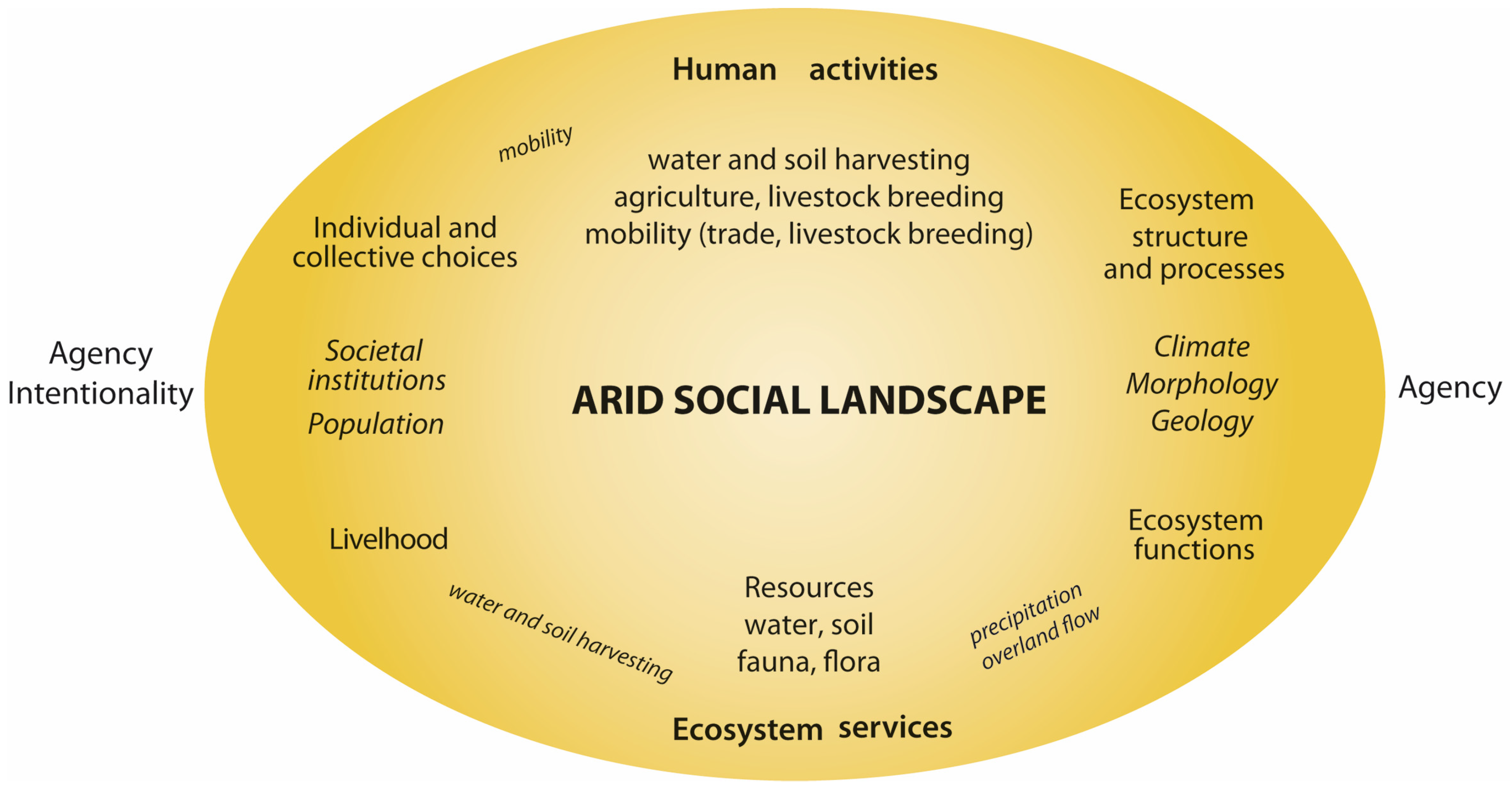
1.1. Arid Social Landscapes and Archaeology

Since resources—first of all water but also soil—are limited, the carrying capacities of arid landscapes in premodern times can be assumed as being even smaller than today. They are and were marginal landscapes not only in ecological but also social regards, which is reflected in lower population densities in arid regions, since not as many people can and could live on the scarce resources in arid regions compared to more humid regions—if resource availability is not drastically enhanced, which is facilitated through technological developments in modern times. In the past, people had to adapt to the arid environment and they transformed the landscape in order to improve resource availability and minimize risks and uncertainties regarding their livelihoods and subsistence. The mutual influences of (wo)men and landscapes happen on various scales and in different realms of the socio-ecological system, such as space and connectivity or social practices to inhibit the stressors. Hence, the long-term utilisation of arid landscapes in premodern times has formed specific landscapes with specific livelihoods, such as mobile life strategies [1]. Using larger spaces through mobile life strategies means having access to more resources in the resource-poor environment as base of people’s subsistence.
The scarceness of resources leads to low population numbers and specific life strategies. For archaeological records, this means that they are also not numerous in arid landscapes—neither in quantity nor category. The lack of data has to be compensated by multi-disciplinary, even transdisciplinary, approaches in the study of past arid landscapes [2].
Instead of using socio-ecological systems used in environmental studies or in environmental sociology [3], in the context of this paper, I combine the notion of the ‘social’ with landscape, which strengthens the ‘human side’ in landscapes, which is implicit in landscape but rarely explicated. Even though in landscape studies, the term in Germanic languages ‘Landschaft’ or ‘landscape’, in Romanic languages ‘paysage’ or ‘paesaggio’, is understood rather as a (wo)man-made surface and habitat of the earth as it prevails also in its etymological origin—land that is ‘scaped’, formed or made, in German ‘geschaffen’, deriving from the Middle English or Old Dutch ‘scap’ or ‘skap’, meaning quality, condition, constitution, shape, but also act, power, skill. The term social landscape is understood as ‘encultured and enearthed’ [4]. It covers, for example, aspects of vegetation as well as of socio-economic practices, of geological forms as well as of route systems. The term landscape implies an etic, human perspective on a natural land surface, which is an historical archive and not only a set of ecological parameters. This anthropogenic aspect of landscape is emphasised by the addition of ‘social’ to the landscape [5]. A social landscape is an enlivened landscape, a dynamic system which forces interaction, embracing co- and counteracting between the more natural and biophysical pole as well as the more human, social pole [6] (Figure 2).
For the special case of arid environments, which are central to my argument, the social landscape is characterised by
  • A regime of risks of ‘too much’ or ‘too little’ water (‘gluts’ and ‘dearth’ as extreme forms of availability or unavailability),
  • A distinct logic in livelihoods and strategies of subsistence as a response to risk and stress,
  • A topographical fragmentation or “patchiness” of productive, less productive areas of the region,
  • A distinctive concept of space and a distinct regime of communication—large spaces, few people, but a high degree of organisation in order to function.
These conditions, prerequisites and resulting life strategies of arid landscapes as marginal landscapes make social landscapes either more resilient or more fragile when climatic, social, or economic parameters change, which would put stress on the system or parts of it [8]. Stressors to plants, animals, and humans in an arid environment are first of all water scarcity and variability, so this element will be the focus of the following arguments on the resilience of an arid social landscape.

1.2. Approaches to an Arid Landscape in Archaeology—The Eastern Marmarica as a Case Study

In order to analyse and study an arid social landscape, a number of methods have to be applied and adopted—geoarchaeology, pedology, survey and excavation archaeology were the basic set of methods and approaches, complemented by the material analyses (mainly pottery) used in the Eastern Marmarica Survey.
The data collection of climatic and environmental parameters in an arid landscape focuses mainly on hydrological and pedological conditions—humidity, fluvial geomorphology, vegetation geography, sedimentation and Aeolic impacts. Historical and recent surveys, for example, of precipitation or soil conditions of the present-day landscape, have to be integrated into the analysis of these data to enable a reconstruction of the palaeoenvironment [9]. In the course of the project, stratified and C14-dated archaeobotanical evidence as well OSL-dated sediment fills form the base of the palaeonvironmental reconstruction; beyond this, analogies and comparisons complement the image, whereas further geo-archaeological sampling and analysis was not possible in the course of the project. Once past environmental factors are understood, one can assess the availability of resources and the technologies people applied in order to reconstruct livelihoods, social organisation and socio-economic relationships. For historical periods, at this point, written sources also have to be considered, since they may contain glimpses of life strategies and people’s socio-economic and -cultural connections.
Despite the fact that the comparison of the practices of groups living later or recently in the same environment can mislead our ‘reading’ of the conditions and influence our interpretation of processes in antiquity, presupposing a historical continuity [1] and ref. [10] (for a criticism of this methodology), inquiring into anthropological material and travel accounts on agricultural methods or economic relations from the 19th or earlier 20th century can support a better understanding of the material from Graeco-Roman times [11,12,13,14]. When comparisons of socio-environmental parameters are vigilantly applied to the reconstruction of past societal systems, a more detailed picture of social and socio-economic behaviour and practices can be obtained, as for example the organisation of mobility and movements, the frequentation of places, the economic production and connectivity [15].
To this written and documented evidence belongs historical cartographic material which offers a record of now lost places, visible traces, or courses of routes and places. Even though this approach enters the field of ethno-archaeological or historical anthropological comparison, it offers access to the study of organisation of space and mobility patterns in an arid social landscape [16] and ref. [17] (pp. 460–463).
Since a resource-poor environment correlates with a rather find-poor environment, it is not only anthropology, but also prehistory and methods from natural science (OSL dating, micro-morphology of utilisation horizons etc.), which are useful, because they develop methodologies and techniques to analyse phenomena such as periodical movements, the frequentation patterns of places, the utilisation of material objects, etc. Much of the evidence in arid social landscapes consists of surface finds, since stratigraphies are shallow and horizons of utilisation scarce and not very thick [18] and ref. [19] (23–25 on the assessment of surface finds) (Figure 3, Figure 4 and Figure 5). In many cases, this leads to a non-stratigraphically build-up body of material. Secondly, and unlike groups in prehistoric times, even in historical periods (Graeco-Roman times in this case), multi-sited communities or nomadically living groups did not live with a large quantity of objects and relied on temporary camp sites. Only through the combination of records, data, and material as well as methodologies can results be obtained, which can be difficult in Egypt because of sample export bans and limited laboratory facilities.
Starting from the described approaches which cover the more data-related documentation and interpretation of the geo-and biophysical as well as the human and social phenomena and their material reflection in an arid region, I first have to introduce the concept of resilience and explain how resilience as a modern concept in the field of ecology to psychology and economy [21] can be applied to an “natureculture”-complex, a landscape, of the past [22]. Then the social landscape of the Eastern Marmarica will be introduced, in order to research the resilience of arid landscapes, and applied as a descriptive and analytical concept in interdisciplinary studies of landscapes and in landscape archaeology [23]. For the purpose of the analysis of the material from the past social landscape of the Eastern Marmarica, I will work along three categories that allow a connection of geo-archaeological and socio-archaeological data and approaches. These categories are events [24], practices [25], and knowledge [26] (see Figure 2), that correspond—not fully, but almost—to the characteristics or arid social landscapes mentioned above. They may help to overcome the dichotomy in the data of the eco-facts and arti-facts that obscures the complexity of the systems in order to understand the socio-ecological system. All categories are reflected in archaeological records and physical-geographical material and data. Events such as rainfall and practices such as constructing fieldstone walls to obtain fields are linked by people’s knowledge. In this combination of methods, records, and approaches, which will not be described in full detail, the resiliencies in and of the system will be assessed2. Approaches to the Concept of Resilience in Social Landscapes and LandscapeArchaeology.
What can be resilient and what might resilience of an arid social landscape look like? How can the adaptation of people to the specific conditions of a water-scarce environment and its climatic, biological, and geological conditions and the impacts and changes in the landscape be seen through the lens of resilience?

2. Definition and Problems

To start with the common definition of resilience, as understood and applied in either ecological, economic or psychological contexts, it is the capacity of a system or individual “to absorb disturbance and reorganize while undergoing change so as to still retain essentially the same function, structure, identity, and feedbacks” [21] and [27] (p. 6). Resilience means the ability of a socio-political or ecological system, of an organisation or of individuals to recover after a shock, to keep going even though they have experienced changes they were able to absorb and adapt practices and ways of living to a changed state of being. Resilience includes both an aspect of stability or conservatism and the aspect of transformation and adaptation, as long as some characteristics of the former state are still recognisable (often defined by an etic entity, such as researchers, or by emic groups, such as elites). Further, the ability to marginalise the losses, which might have resulted from stress or crisis, belongs to a reaction leading to or enhancing resilience.
Resilience as a paradigm in research started off as looking at larger systems (ecosystem, economic system etc.), but in the wake of socio-constructivist and science-technology studies from the 1980s [22,28], there was a turn in resilience studies to inquire into socio-psychological and socio-ecological resilience, including multi-level perspectives, which allow the consideration of subsystems or co-occurring systems [29,30]. These differentiated approaches to resilience help overcome the nature/culture split which runs through many socio-ecological and archaeological studies [31,32,33].
Recent research and projects try to connect the individual and the societal-collective layers when looking for resiliencies on the one hand, and to bridge the disciplinary borders researchers have to transgress on the other hand [34,35,36]. Resilience is not a property but emerges in relations between and dependencies of agents and factors and is a highly relational concept. Resilience turns out to be a feasible descriptive and analytical concept to examine the interactions and relations of the environment and humans [37]. Multi-level perspectives as well as a historicising approach are necessary to make use of resilience as an analytical concept, in order to know about the scale the study looks at on the one hand (micro-, meso-, or macro-scale, corresponding, for example, in the case study with a wadi catchment, the Marmarica Plateau, or the fringe of Saharan Desert), and about the interpretative powers on the other hand [38].
In research, resilience tends to be often essentialised for the purpose of explaining adversities and catastrophes while a system keeps ‘stable’ [39] (pp. 201–202). However, if it is used as a normative term, it needs a clear definition of [31] (pp. 4–8) and ref. [40] (pp. 87–90 with a contradiction to normative aspects of resonance pp. 104 and 106). When it comes to the application of resilience, the determination of the areas and scale in which one looks for ‘change’ or ‘sameness’ as well as the definition of what was the ‘state before’ has not to be essentialised but is discursively negotiable [41,42], ref. [43] (call the system also “socio-ecological-techn(olog)ical”) and [44]. If resilience is about the reaction to disturbances, from long-term stresses to acute shocks and disruption aiming at restoring the previous state, we also have to clarify what a stressor or disruptive impact is and how differently a system, people, a landscape or parts of them, react to it [45]. It is an etic and not fixed concept, whose meaning and content depends on ascriptions of what is resilient towards which stressors [46] and ref. [47] (partial perspective of humans). Ascriptions bear the risk of giving resilience a normative character, where only in a strictly historicising perspective, deciphering interpretative powers in a system and its entities looked at [48]. The same is true for continuities and discontinuities, important in historical research, which can also be normatively loaden, depending on the perspective [49].

2.1. Resilience in Systems of the Past

Resilience as a modern concept cannot be transferred directly to ancient studies. It is not an emic term or concept in the mindset of people in the past. However, many activities, practices, institutions and technologies show that people in ancient times applied material, narrative, or performative practices to explain (retrospectively and prospectively, e.g., in funerary speeches), to find relief (e.g., memorials, religious festivals) or to re-arrange shaken systems (redundancy, prevention, e.g., grain storage, building techniques) the changed conditions, so that we can call it a resilient reaction or resilience of the ‘systems’ and co-occurring systems [50], such as populations, economies, trade networks, marriage alliances. However, we need to clarify the standpoint of what to understand as resilience in a certain case and ascriptions of identity and sameness to a state before. Resilience makes only sense if the human perspective is explicated, especially when it comes to landscape studies. So, the concept turns out to be a good descriptive and analytical tool for the study of marginal social landscapes where human beings are exposed to more stressors than in more temperate regions.
A system which is not fragile and not easily breaking up but can resist shocks and changes can be called resilient. Hence, an arid social landscape does not seem to belong to such a socio-ecological system. However, as mentioned above, resilience is an etic term, and should not be used in a normative way implying that ‘not breaking up’ is considered ‘better’. From a cultural-anthropological view, the concept of resilience is able to overcome the nature-culture split. However, it should be used strictly descriptively and analytically instead of normatively in order not to interpret the human or climatic impacts on a landscape as improving or worsening. Since a landscape is a dynamic system on a temporally very extended scale, it is only in the combination with the human agent that resilience becomes an issue [39,51]. Only the people inhabiting a landscape had (and have) an understanding of what a landscape, animals, plants, and the humans look like, how they conceptualise it, how they live their lives, and what use they make of the landscape. Humans act with agency and intentionality (see Figure 2), whereas the biophysical landscape enacts only agency (‘events’) [52,53]. I argue that a social landscape has resilient features and the people using it can cope with stressors. A landscape cannot be resilient, a landscape exists. Even though this seems to be an essentialising statement, the landscape does not care about the changes.
Resilience as an analytical and descriptive category in historical research has to be used context- and perspective-related. It is productively applied—also to historical social landscapes—when it is used as a descriptive tool to grasp the tension between system and agency, between stability and ongoing change in societies, their entities and institutions, or individuals as well as their interrelations, of ecosystems or economic networks [30]. Dissonances and irritations can result from this tension and have an influence on landscapes, societies, technologies, or religions. In the worst cases, catastrophes and shocks can disrupt. How strong this influence or these disruptions are depends on their intensity, the scale which we look at, and the relationships of the various elements that take part, as for example climatic impacts, markets, administrations, social groups, or religious concepts. Parts and subsystems can be influenced differently.
Resilience is also a useful analytical concept in historical research to examine how frictions were reduced, opportunities enhanced, or a status quo of a regime or interrelated regimes maintained (such as climatic and economic regimes or two conflicting communities). It is not synonymous with adaption, resistance, or flexibility and should not just replace these terms. Its strength lies rather in opening our perspective to uncertainty and variabilities in systems and parts of them. Its analytical power coincides with its focus on processes as well as on action and reaction—in human–nature relations as well as social relations.
To apply resilience in combination with a multi-level perspective on a past social landscape is productive because it allows to consider the different scales in the systems’ entity and parts. Different scales apply to time and space, since an eco-system can be much larger and long lived than the groups inhabiting it. Social and individual time differs from the ones of plants, animals, climatic and geomorphological changes (ecological time). Groups might be resilient but not an individual and vice versa. Parts of an ecosystem or social system may survive unchanged, others may not. Stability on a community level transgresses also the individual and generational life spans which are in most cases shorter compared to ecological time spans. Only a natural catastrophe might have the same immediate effect on the social system as well as on the ecological system, where it leaves archaeological and geo-archaeological traces. However, the difficulty for (geo-)archaeology is that often the fine resolution of chronologies in the archaeological and palaeoenvironmental record is missing or technically unrecognisable, so that the differentiation of short-term variabilities is rarely possible [54,55,56].

2.2. Categories to Approach Resilience in an Arid Social Landscape

Arid social landscapes induce a specific interaction of humans and the geo- and biophysical parameters [57]. This interplay is closely linked to the resource water. Precipitation is variable, its absence poses a risk to plants, animals, and people; dry years and droughts are common. ‘Gluts of water’ in the rain season can vice versa cause extreme damage because of the accumulation of rainwater in the wadis. These are the events, related to water and soil, to which as another meteorological impact wind could be added influencing soils, morphology, plants, animals, and humans (Aeolic and fluvial regime) [58].
People develop specific practices to adjust and adapt to the environment as well as to the socio-economic domains and networks to which they belong or in which they are embedded. The practices of people in the ancient Marmarica which we can detect archaeologically comprise agricultural activities, dwellings, burial practices, pottery making and utilisation, diet, as well as trading.
The practices are based on knowledge, including the awareness and knowledge about the unpredictability, the uncertainties; knowledge about how to improve water availability and how to balance its variabilities. Detailed knowledge is necessary to use and navigate the landscape where water and human occupation are only scarcely distributed. The collective and individual factor comes into play here, since (part of the) knowledge lies in each individual; yet it is also a collective knowledge, passed on from generation to generation. Since knowledge, which can be a tacit and embodied knowledge, is closely related to practices, the two will be dealt with together.
Social landscapes reflect and are outcomes of events, practices, and knowledge and they are also a part of it. Hence, landscapes are assemblages of human (individual/social), natural (animated/unanimated) and technological factors [59,60] and ref. [61] (p. 1094 the strength of assemblage “lies precisely in their capacity to deal with coexisting complexities, keeping open their multiplicities without reducing them to singularities”). Looking at landscapes as assemblages of events, practices and knowledge allow for a systematic analysis of data sets, while at the same time the option to adjust or enlarge the data sets or to connect them to another (part of the) ‘system’ can be kept open [62]. The assemblage allows to easier switch from a micro-scale to a meso- or even macro-scale as well as including a meta-level in the study and adjust the design accordingly.
For a detailed analysis of the applicability and the value of resilience in a historical landscape, these three categories allow to bridge the human and the natural aspects of it. Using the example of the Eastern Marmarica in NW-Egypt from the Bronze Age to Byzantine times, I will exemplify the range of factors, agents, and their relations, be it land surface, morphology, water, soil, climate, humans, productivity, plants, or animals.

3. The Arid Social Landscape of the Eastern Marmarica and Its Resiliencies—Long-Term Continuities and Short-Term Variabilities

An arid social landscape can be investigated against the backdrop of resilience according to the main characteristics described above—(i) scarceness of resources, (ii) adaptive strategies for production, (iii) patchiness of utilised areas, (iv) space, communication, and mobility. We can ask about its resiliencies while being under permanent stress, mainly induced by the scarceness of water. Animals, plants, and people live at risk, mostly, by not having enough water and land to put down roots, by not finding food to reproduce or to grow crops and breed livestock.
A clear-cut set of questions about the resilience of a social landscape has to address the skills, options, and techniques which adapted species have and had developed to survive in arid environments, and in what ranges and magnitudes they are successful in adjusting themselves (reorganisation in the adaptive cycle [29] (Figure 1 and Figure 2) to hardening or adverse conditions, influences and changes (release in the adaptive cycle). Moreover, the periods and time spans in which they adapt need to be assessed historically.

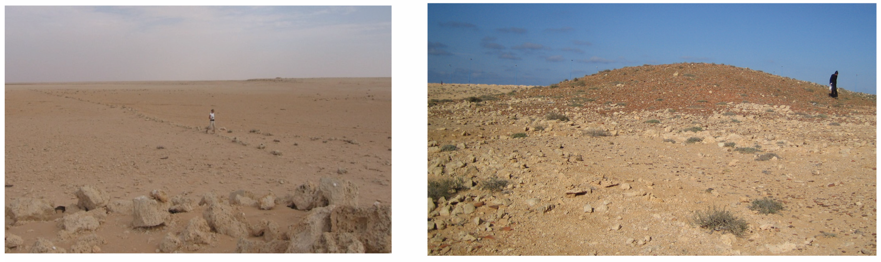
3.1. The Ancient Marmarica

Research was conducted on the Eastern Marmarica Plateau in northwestern Egypt between 2004 and 2011, aiming at a reconstruction of the interrelation of landscape, economic potentials, life strategies, and habitational patterns as well as route networks in this semi-arid to arid area between the Mediterranean coast and the Qattara Depression in Graeco-Roman times (Figure 1 and Figure 6). The design was interdisciplinary and geo-archaeological, and the study area covered an area 50 km east and west of Marsa Matruh, the ancient Paraitonion, as well as 150 km south of the coast in the direction of Siwa.
North of the Marmarica Plateau, three main ecological zones can be distinguished (Premarmarican Plain, Northern Tableland, Coastal zone) with environmental conditions comparable to today. Only the conditions for people’s livelihood changed from approx. the early 20th century onwards, because of technological developments in, for example, cistern construction, motorised farming, and adapted crops). Life, survival, and livelihood depended in antiquity on the successful management of local resources and adaptation to natural uncertainties. Regional ancient water and soil harvesting systems that were developed over decades or even centuries are a testament to the long-term experience of their builders and triggered special water and sediment dynamics.
The following characterisation of the ancient Marmarica will be cursory, but it mentions the basic parameters of the socio-ecological system.

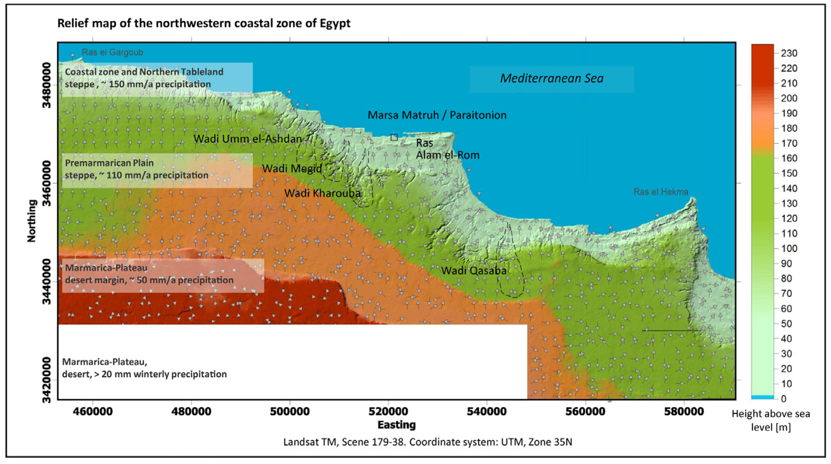
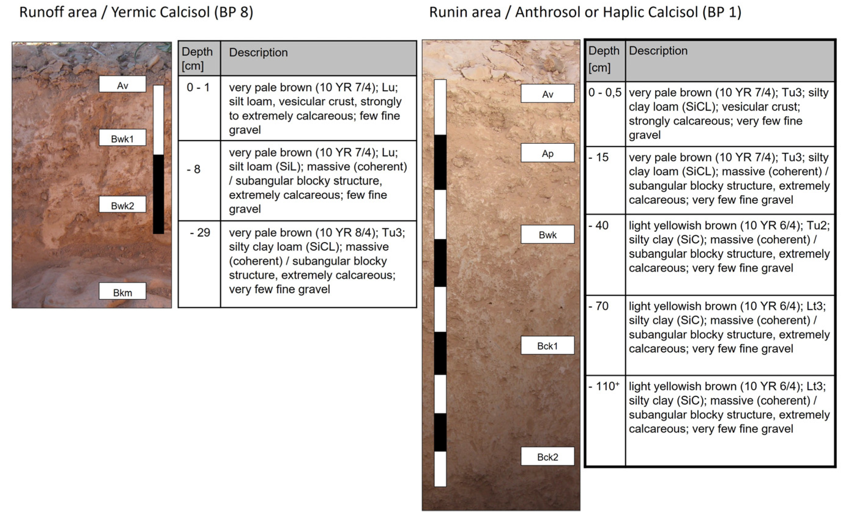
3.2. Geology, Pedology, and Relief
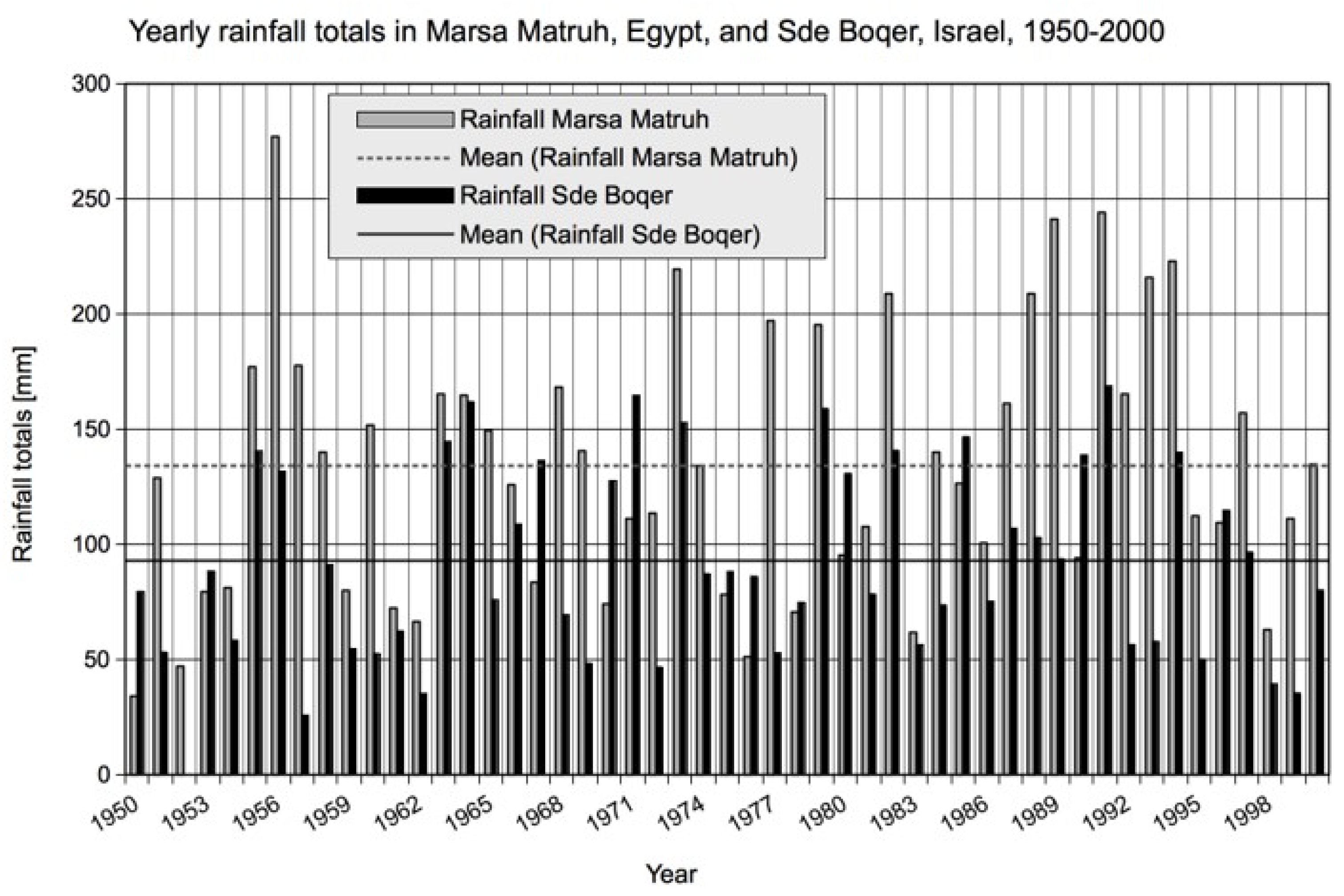
The Marmarica is an arid landscape on the northern fringes of the Libyan Desert, the Sahara. The region is characterised by a sequence of northward sloping plains, interrupted by three scarps. The areas in between form a sequence of almost parallel ecological zones. The coastal zone, which is approx. 5 km wide, has a Mediterranean climate and is formed by the sediments brought down from the escarpment emerging south of the coastal zone raising approx. to 100 to 120 m asl. It leads up to a Table land formation with an inclination of less the 2%. Numerous wadis are cut into this tableland and the escarpment, which drain into the Mediterranean Sea. Their catchment areas reach 20 to 25 km south on the tableland (Figure 6). With the Pliocene Marmarican Cliff at a distance of approx. 40 km from the coast, the Marmarica Plateau begins, continuing on a mean altitude of approx. 200 m asl until it steps down to the Qattara Depression with the Oasis of Siwa. It is constituted of limestone, which is the prevailing geological material [63]. The extension of the Plateau reaches to the west to the Golf of Sollum and to east to the bay of Marina el-Alamein.
The soils of these plains are generally shallow, loamy, calcareous, and stony. In some places, wind-blown sands occur and can form shallow sand-sheets [64]. All fine sediments, including aeolian deposits, can be secondarily relocated because of the dynamic overland flow regime of the fringes of the Marmarica Plateau, as geomorphological evidence proved frequently, for example, on valley shoulders with a pavement of residual soil skeleton on bedrock outcrops.

3.3. Rainfall

Precipitation is the primary determining ecological factor influencing fauna and flora as well as land use by the inhabitants. Based on modern data, maximum seasonal rainfall in the coastal zone does not exceed approx. 150 mm (Figure 7). However, 5 km inland, 160 mm was measured. In the south on the Premarmarican plain and on the Marmarica Plateau, the annual rainfall drops from 80 mm to less than 20 mm. The main wet season is December to February, with high annual variabilities—which are characteristic for arid environments. We have chosen S’de Boqer in Israel as a comparison with less mean annual rainfall, however, variabilities there have very similar patterns and amplitudes.
The entire region lies below the limit of rain-fed agriculture at 200 mm/a and only allows dry farming, which according to palaeoenvironmental studies in the Eastern Sahara and the results from our research, mainly based on the archaeobotanical micro- and macro-remains, but also on archaeozoological evidence, was not different in the time period covered in this study [18,66], ref. [67] (pp. 42–43 with references) and ref. [68,69], so that agricultural utilisation of the region is only possible through water harvesting methods. An attestation confirming the meteorological regime from Roman times exists in the form of a graffito scratched into the fresh plaster of a cistern close to Paraitonion, which is now lost: A certain Isalas has imprinted his hand and his name in the fresh plaster, as well as an altar palm branch and the date of August of the year 6 BCE. This could only have happened when the cistern was empty [70] (Figure 8).
Today, water supply is—as studies of the correlation of income of the rural population and precipitation show—the critical factor for agricultural yields in the arid environment of the Eastern Marmarica and can be assessed for Graeco-Roman antiquity. Water stress was the main issue.

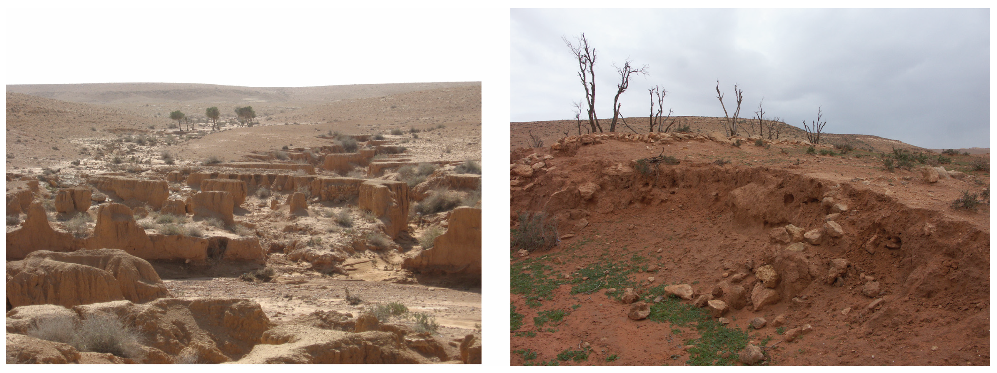
3.4. Overland Flow, Wadi Runoff and Soil

Morphology, topographical features, and conditions of the land surface play a big role for water availability as they influence the overland flow of precipitation. On the one hand the overland flow was (and is) technically altered to enhance water availability (see below Section 3.6). On the other hand, flood protection is an issue whereever overland flow accumulates in wadis, as this can have devastating effects on agricultural areas and plants as well as animals and people. Therefore, both control and redistribution of the overland flow on the slightly northward sloping Tableland and Marmarica Plateau which form huge catchment areas, and of wadi runoff play a role for the water supply (Figure 6). The water and soil harvesting measurements are suitable for adding up to a surplus of water flow over the tableland and into the valleys, from where the tableland, the valleys, and the coastal plains, which already receive the highest rainfall, receive harvested water, that can add up to another 150 mm to reach the minimum threshold for cropping cereals such as wheat or for tree cultures.
The water harvests which the land-units receive through runoff are sufficient to fill the supply gap for agricultural use, which would in more humid areas be filled by precipitation. However, this is only possible through another factor—soil. The water storage capacities of soil, which naturally accumulates in depressions or which is artificially accumulated behind terrace walls or embankments, increases the amount of water available to plants (Figure 9 and Figure 10).
In the Eastern Marmarica, the soil depth in the valleys and on the tableland was significantly increased by ancient water harvesting interventions from the 2nd millennium BCE onwards (Figure 11 and ref. [71]). The deepest soils occur in valleys, on alluvial fans, in coastal plains and endorheic depressions. Tableland soils are generally shallow, rarely deeper than 0.3 m. Deeper soils or relics of deep soils are frequently related to ancient water harvesting schemes. Today, the old wadi fills turn increasingly into badlands due to lacking water management. In some cases, wadi fills are almost completely removed, leaving behind barren rocky beds [72].

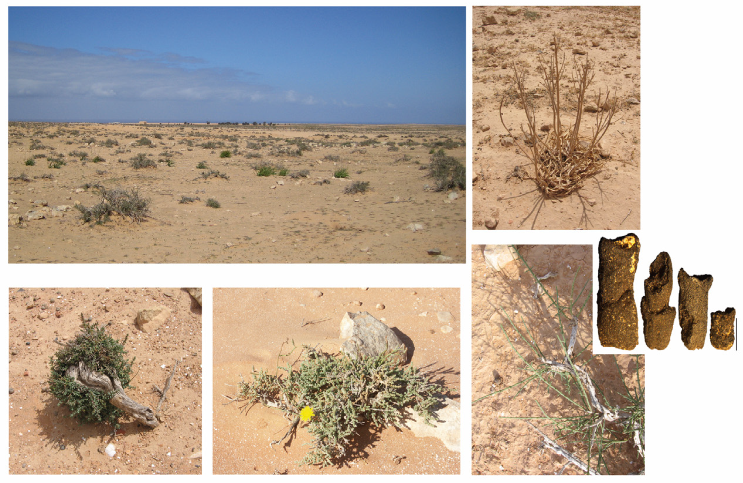
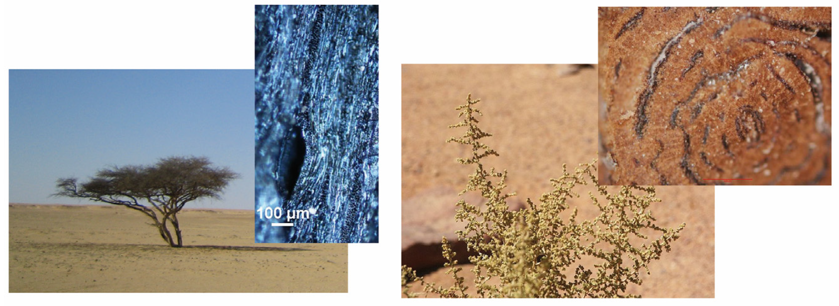
3.5. Natural Vegetation

The endemic vegetation is made up of a plant spectrum typical of steppe environments, with the exception of a small strip of Mediterranean climate along the coast with a typical vegetation of smaller trees and shrubs [73,74] and ref. [75] (as comparison, however, the Marmarica is drier because of the Lee position to the Jebel Akhdar). On the Northern Tableland (down to 25 km south of the coast), plants have to be more drought resistant. The endemic species today are shrubs such as Artemisia inculta, Atriplex halimus or Salsola, a shrub belonging to the family of Amaranthaceae. Remains of these bushes were also found in an archaeological context [76]. Asphodelus gymnocarpus, Thymelia hirsuta can be found today, but were not found in the archaeobotanical remains [72,76,77] (Figure 12).
Their distribution is scattered and patchy due to the limited water availability and nutrient-rich soil. Wherever larger soil accumulations or depressions appear, the vegetation becomes denser. Grassland, however, does not exist.
Further south on the Premarmarican plain, vegetation of the above-mentioned kind is contracted in favourable places that provide enough water, such as depressions (see Figure 6 for the zoning). Desert conditions prevail from 90 km south of the coast to the Qattara Depression. Only Acacia trees grow in very favourable places, of which we have also archaeobotanical evidence (Figure 13, left) [18,73].
Even though we could not conduct an in-depth palaeoenvironmental analysis, the vegetation (and environmental conditions) do not seem to have changed much from the 2nd millennium BCE to today (they could, however, change in the near future because of global warming) [9]. Some archaeobotanical remains point to exactly this fact: it is Chenopodiacaea and Amaranthaceae; endemic trees were Tamarix, Acacia, and Phoenix (date palm) as is the case still today (Figure 13).

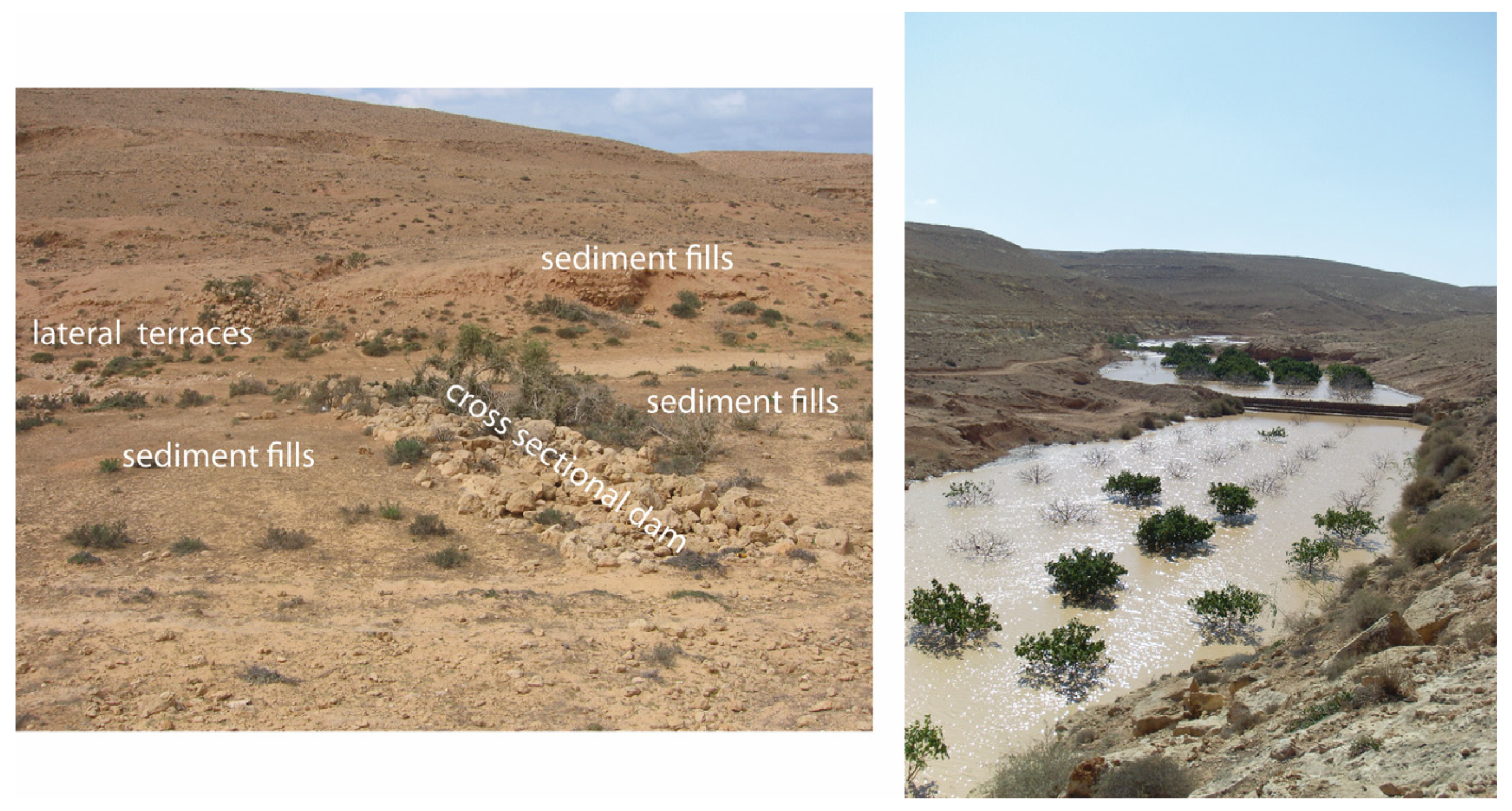
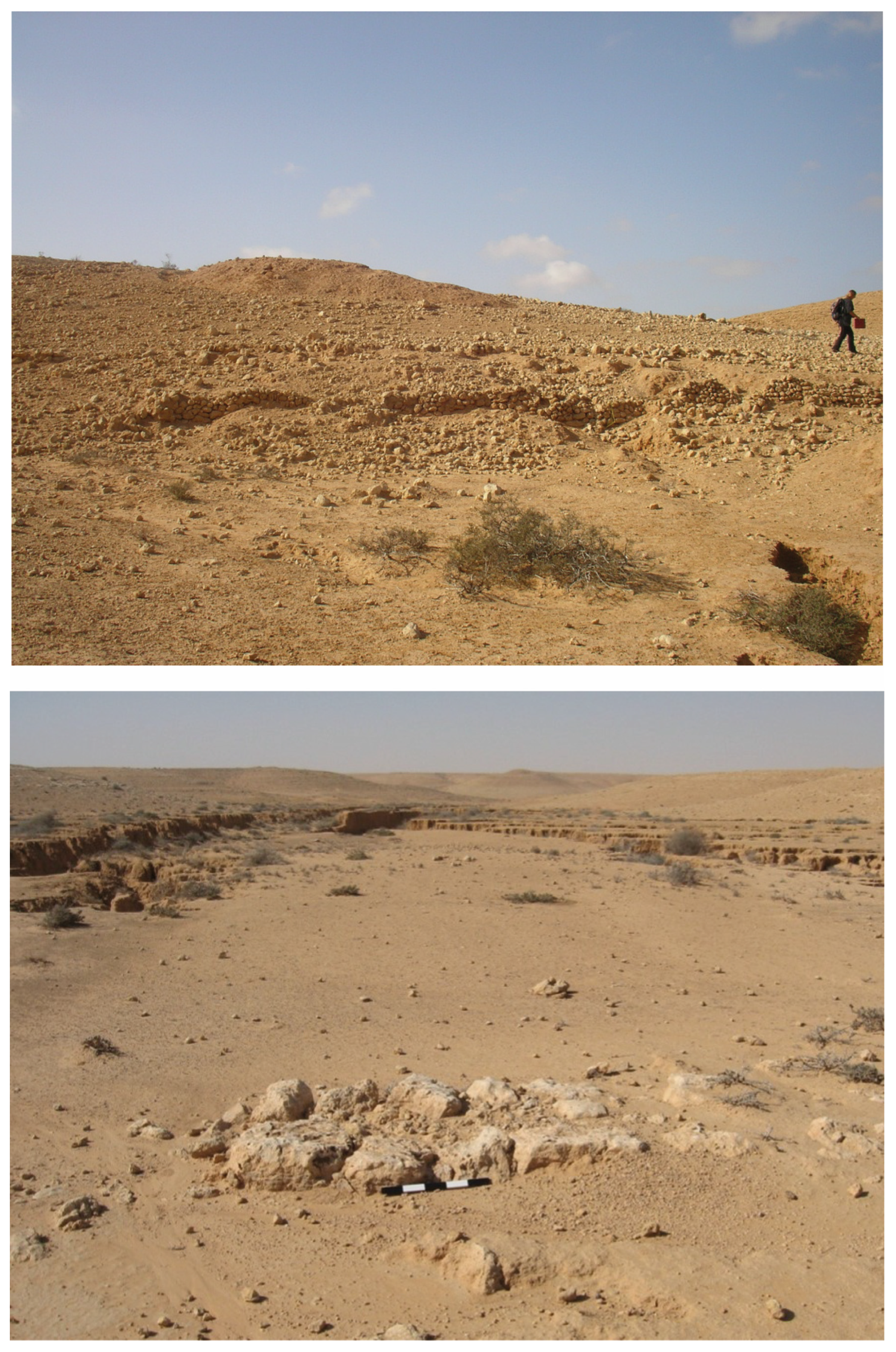
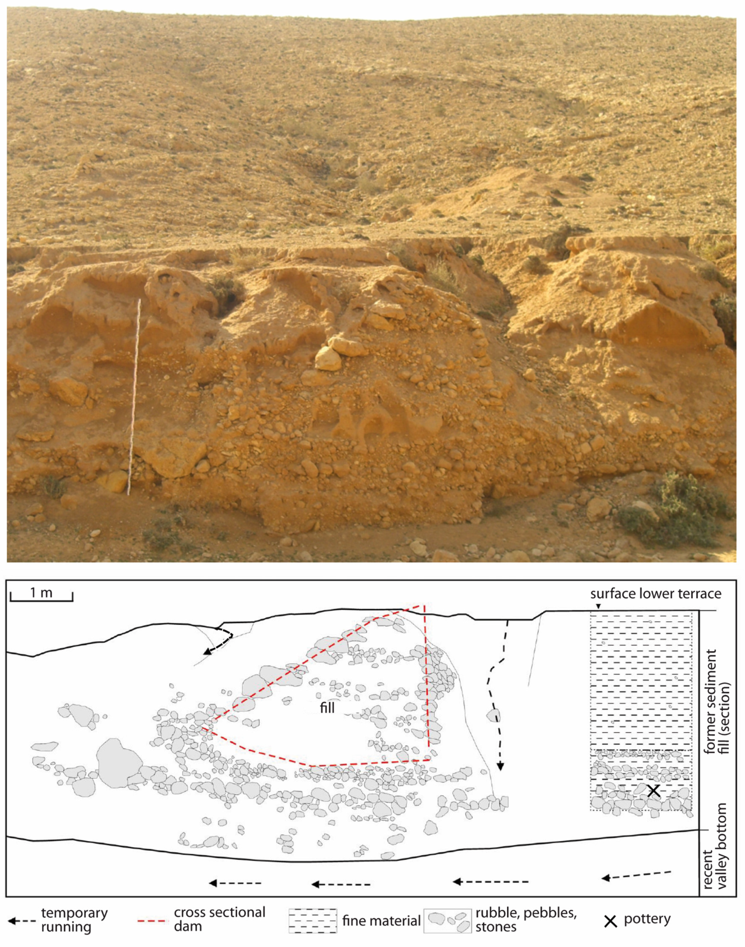
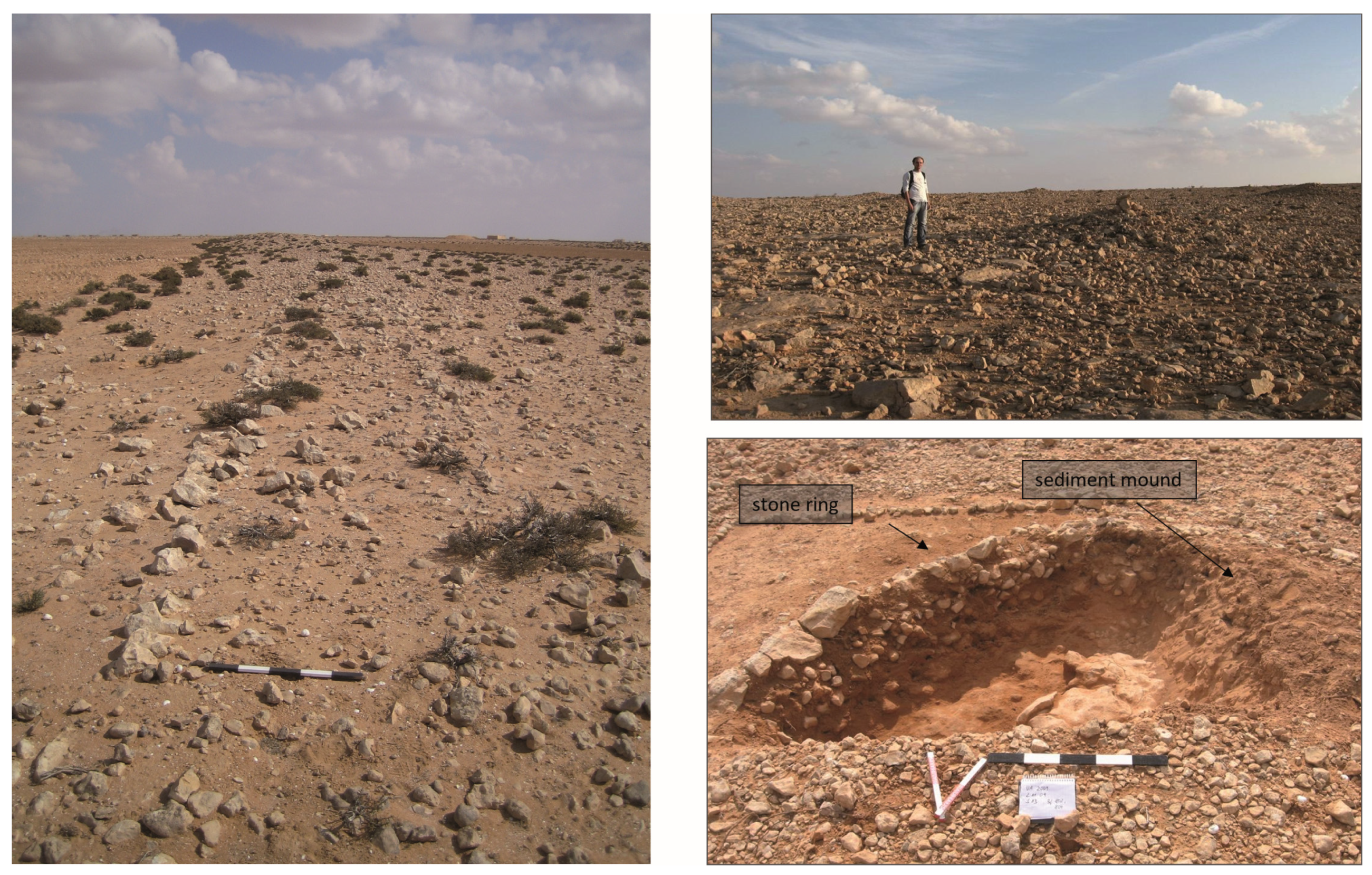
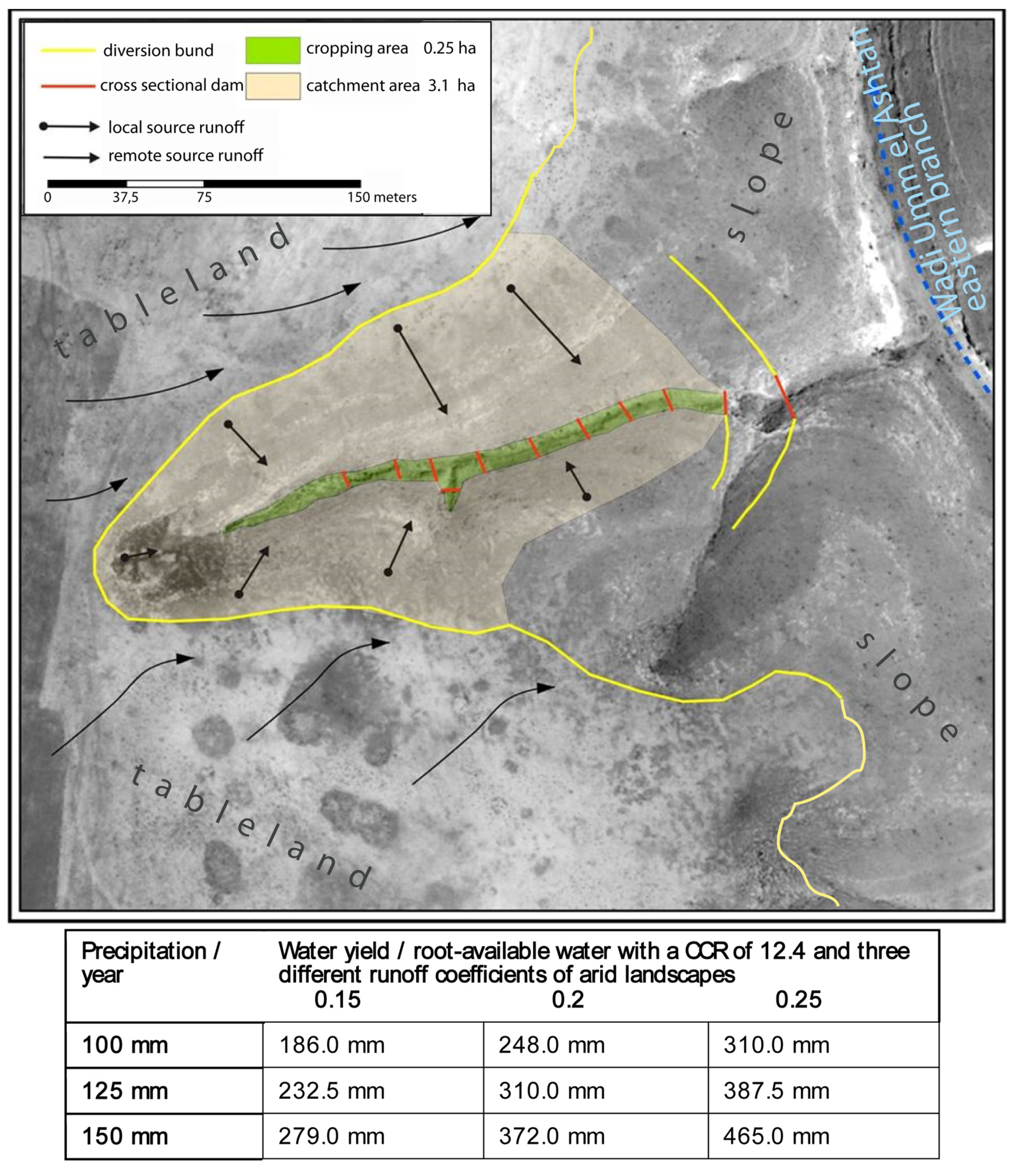
3.6. Water and Soil Harvesting

As already mentioned above, people living in the Eastern Marmarica in the Bronze and Iron age, i.e., Graeco-Roman period, built various and far-reaching installations and structures from the abundant field stones to enhance water control and availability. These regional ancient water harvesting systems were developed and adapted over decades and centuries and reflect the experiential knowledge of their builders and users about the hydrological regime that they had acquired over a long period of time. This knowledge was gained through the special water and sediment dynamics typical of the region and its micro-units and zones.
The systems consist of dams across the wadis or tributaries, of lateral terraces along the wadi slopes, of diversion bunds on the plains on the Northern Tableland in which the valleys are cut (Figure 14 and Figure 15) as well as of terraced fields on the tableland, made by embankments from earth with stabilising rows of stone inside. The latter ones—the tableland fields—are a unique feature in the Eastern Marmarica in comparison to other arid landscapes of the Mediterranean (such as the Negev, Tripolitania or Tunisia), since they are located in the runoff area and not in a classical runin area [63,78] (Figure 16). According to the ratio of catchment to cropping area (ccr factor)—the root-available water on the tableland field is sufficient for barley, in the valley for wheat and tree cultures (Figure 17). The oldest installations could be dated via OSL to the 2nd millennium BCE, continuing through the 1st millennium BCE to reach a peak with the most extensive installations during Roman times. We dated thirteen sediment layers in five sections via OSL. Samples were taken by night, analysis was done in Bayreuth by Markus Fuchs and is described in more detail in [63,71].
Another structure made for water harvesting (rather than for soil harvesting) and used as agricultural unit is stone mounds. They have a diameter of approx. 1.0 m to 2.0 m and rise between approx. 0.5 and 0.8 m from the surrounding surface. Filled with sediment, reaching down also to approx. 0.5 and 0.8 m is covered by cobbles and leads to the assumption that they were used as planting mounds by the inhabitants of the Graeco-Roman settlements on the tableland. The sediment could have stored the soil moisture, whereas the stone cover prevented it from evaporation. Even though their hydrological and pedological characteristics are not yet finally analysed because of the end of the project, their features, their location and distribution indicate their function as teleilat el-einab—for grape growing, comparable to a kind of mound in the Negev [79,80].
The most classical water harvesting installation is physically not so much changing [80] the landscape as the water and soil harvesting installations, however, it is extremely numerous: the cistern. On the Northern Tableland as well as on the Premarmarican Plain and the Marmarica Plateau, cisterns are dug into the limestone underground to collect the water from the winter rains. The cistern of Bir Helua on the Marmarica Plateau in Figure 18 is one of several such water supply points, which we surveyed in the Eastern Marmarica Survey. Many have been constructed only recently, as there was a huge development plan of the Egyptian government. However, many date back to pre-modern and even ancient, often Graeco-Roman, times, as the analysis of old cartographic material and the surveys show. The density of the cisterns corresponds to the rainfall gradient, decreasing from north to south. While several cisterns can be counted per square kilometre in the north, only two to four can be found 50 km south and less than one cistern per square kilometre can be found 150 km south of the coast (Figure 19).
Figure 18. The cistern site of Bir Helua on the Marmarica Plateau (see cistern map below in Figure 20) is still in use today, but shows remains (pot shards) also from Graeco-Roman times. It is one of the several water supply points between the Mediterranean coast and the Qattara Depression with a long history of frequentation. In the foreground one sees the manhole to the right and a water trough to the left. The heap in the background are the remains from a building, most probably from Graeco-Roman times comparable to but smaller than the ones at Abar el-Kanayis (see cistern map below in Figure 20). A.-K. Rieger.
Land 12 01109 g018
Figure 19. Distribution and number of cisterns according to rainfall and the ecological zoning in the Eastern Marmarica. Data are taken from the series P502 of the US Army Map Service, Corps of Engineers, scale 1:250,000, using map sheets of the Middle East Forces (UK) 1941/42 based on information compiled by the British “Survey of Egypt”. Since the rainfall pattern did not change very much from antiquity to today and all cisterns beyond the 20 km line south of the coast we surveyed date back to the Graeco-Roman or an even older period, the general ratio might have been similar in antiquity. Owing to denser settlement and government support, the closer to the coast (0–20 km) you look, the more modern constructions of cisterns can be found. Th. Vetter in [17] (after Figure 2).
Land 12 01109 g019
Figure 20. The mapped cistern sites surveyed in the Eastern Marmarica Survey all date from Graeco-Roman times at the latest and some of them were equipped with rest houses for the travellers and merchants on the routes between Siwa and Paraitonion/Marsa Matruh and the Mediterranean coast in antiquity. H. Möller/A.-K.Rieger [18] (Figure 2).
Land 12 01109 g020

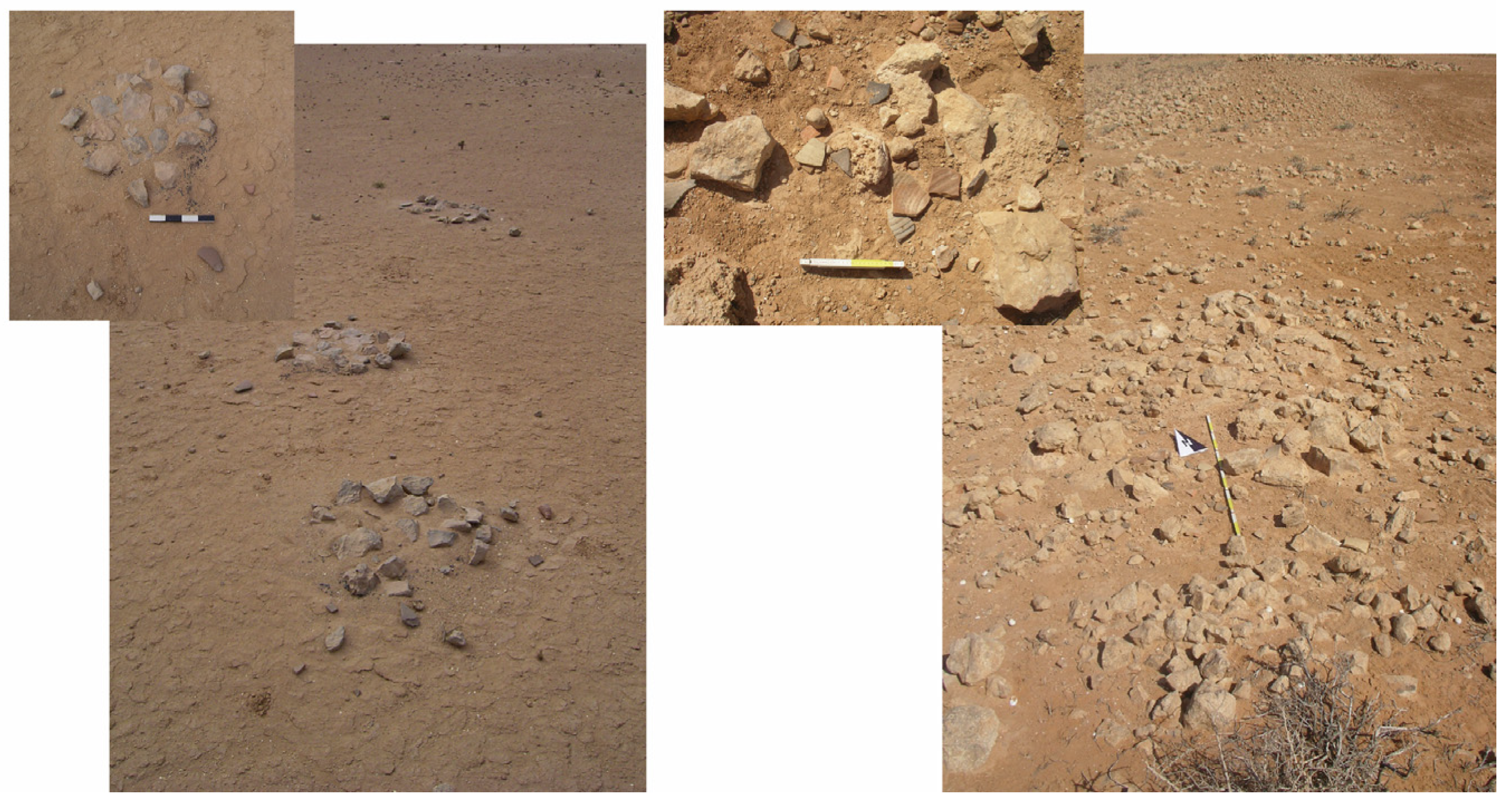
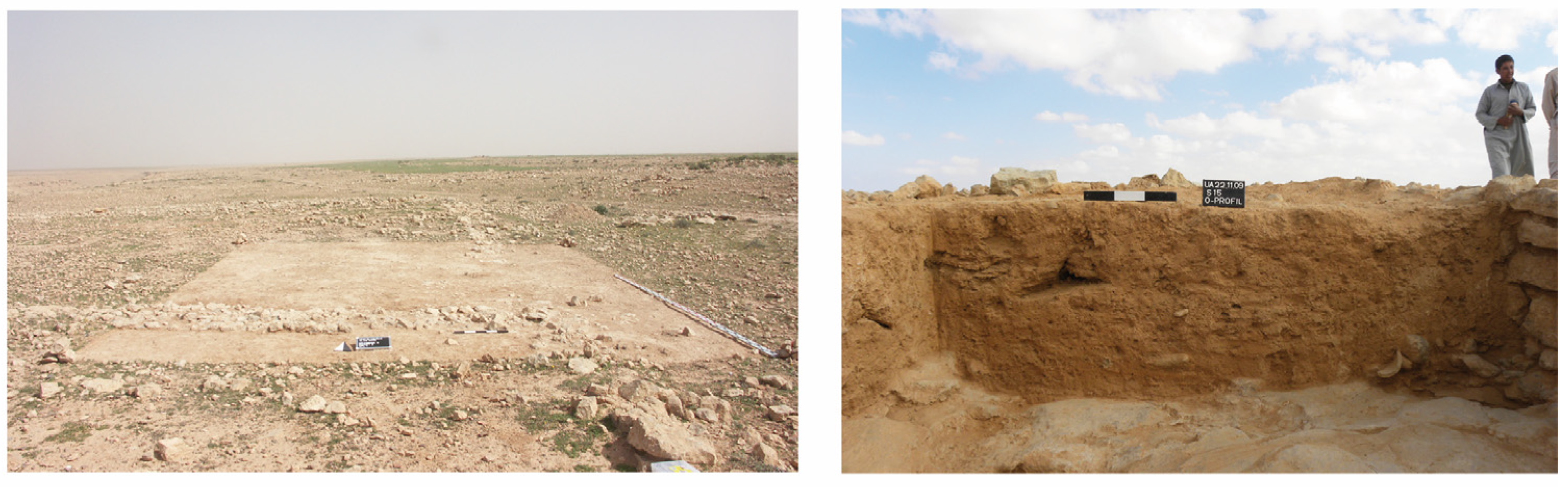
3.7. Living in Ancient Eastern Marmarica

The ancient runoff agriculture in the Eastern Marmarica and its potential is of particular interest in the context of resilience and water as a stressor, because it reveals the ability of people to establish forms of livelihoods and dwell in a niche in an ecological sense [39,51,81,82]. It could be discussed whether arid landscapes still form a niche for dwelling, as almost one-third (26.8%) of the Earth’s land surface is arid regions with a population of 1.1 billion people (excluding populations in deserts and dry subhumid rangelands) [83].
Since the conditions did not change so much from the millennia BCE to today, as explained above [9,66], people in the Pharaonic (if we apply the Egyptian terminology) and Graeco-Roman times had to live in semi-arid to arid conditions in the Marmarica.
From the ecological marginality a political marginality can be deduced, since we have no evidence of political organisations based in the Nile Valley, in Siwa or coming from the Mediterranean in the region during the New Kingdom and in Persian times (Figure 21). Located in-between the better-known and economically powerful regions to the east and west, people in the ancient Marmarica seem to have been rather independent, except for a short-lived attempt at controlling the region under Ramses II, during whose reign the fortress of Zawiyet Umm el-Rakham close to the later Paraitonion was constructed, but without any long-lasting success [84]. Contemporaneous with the fortress, but because of the hydrological knowledge an autochthonous action, are the oldest traces of a water and soil harvesting system and agricultural activity in the region on the Tableland, dated to the late Bronze Age based on OSL data [63]. Even though there are no habitations or other materials that can be attributed to the people using these early agricultural plots, the evidence correlates with the Late Bronze Age presence of Nile Valley Egyptians in the fortress of Zawiyet Umm el-Rakham [84] as well as with Mediterranean connections reflected in Cypriot, Aegean and Canaanite pottery found on Bates’ Island in the lagoon of Paraitonion/Marsa Matruh [85,86].
As a marginal region with a position always between desert steppe and sea, between Nile Valley and Cyrenaica region, the Eastern Marmarica was never the centre of interest and remained rather independent throughout most of its history, even though officially being administratively under Ptolemaic rule from the 3rd century BCE. In the 1st century CE it became a province of the Roman Empire as part of the Crete and Cyrenaica [63].
Who the people inhabiting the Marmarica were is not easy to say, the Temehu, Tehenu, and Meschwesh are mentioned in Pharaonic sources, while various tribes were later listed and repeated by Graeco-Roman authors using ethnic stereotypes for desert dwellers [87]. However, during the later period focused on in our context (roughly the 5th century BCE to 5th century CE), the inhabitants extended and intensified the land-use and changed the patterns of economic exploitation, which is reflected in a higher find density: From the 5th century BCE onwards, the transfer of goods can be traced between Siwa and the coast, while an extension of the route system and its facilities as well as the intensification of its use is attested to from the 1st/2nd century CE onwards, and coming to an end—as far as the pottery indicates—with the 5th century CE [17] (476–480, pre-Roman finds, i.e., finds older than the mid-1st century BCE at Abar el-Kanayis, Bir Qatrani, Bir Abu Mukhayat, Bir Quseir) and ref. [20] (Figure 20). Accordingly, the described water and soil harvesting systems in the arid environment of the Eastern Marmarica reached their largest extent in the period between the 2nd century BCE and the 4th century CE. Barley as well as grapes seem to have been the most important crops, the latter also allowing for a surplus economy, which is inferred from the thousands of stone mounds and the output of the pottery workshops. Wheat played only a marginal role. Tree fruits such as figs as well as legumes could be traced archaeobotanically, but olives could not [63,88].
Figure 21. The route network attesting to trade mobility in Graeco-Roman times as well as to roaming as far south as pastures are available (approx. 60 to 80 km south of the coast). The frequentation of the routes in Graeco-Roman times is attested mainly by the findings of ceramic material. A.-K. Rieger/Th. Vetter [89] (Figure 16).
Land 12 01109 g021
Centres of commerce with an even urban lifestyle included the harbour of Paraitonion (Marsa Matruh) and the smaller Katabathmos Megas (Sollum) on the Mediterranean coast. To the south, the Oasis of Siwa and Jarabub represent hubs for trade in the Libyan Desert (Figure 21).

4. Resilience of and in an Arid Social Landscape—Living with Uncertainties

The three concepts introduced above—event, practice, and knowledge—allow, in combination with the characteristics of the arid environment as can be found in the Eastern Marmarica (scarceness of resources; adaptive strategies for production; patchiness of utilised areas; space, communication, and mobility), to look at the various risks and stressors in the arid social landscape’s system with co-occurring as well as subsystems and how they are interrelated, shifting and depending on each other. With the relational approach we can decipher even more precisely how the entities and subsystems are dynamically established and risks minimized [40].
Having explicated the details of the physical-geographical conditions and the human alterations and the living they could make from it, I will focus on water as a resource and agent, but also on soil when interpreting the social landscape through the three concepts [90,91]. It allows the assessment of biophysical as well as social evidence and material remains.

4.1. Socio-Natural Events—Uncertainties in an Arid Landscape Requiring Resilient Strategies

The concept of ‘event’ disentangles the dynamics active in and having an impact on a system [92] and ref. [93] (p. 9). The term ‘event’ describes a contingent event, which is capable of creating ruptures. The latter can trigger a reaction that strives for resilience [94].
In the context of analysing resilience in and of an arid social landscape, the perspective on water coming down as rainfall helps in the search for long-term continuities and short-term disruptions. Rainfall is of great variability and a very temporary phenomenon, but at the same time periodically appearing in the rain season in winter and thus a persisting phenomenon.
Water can therefore be conceptualised as an event in the Eastern Marmarica (as could be wind in the region): Precipitation is the primary event, overland flow and floods are secondary events in the arid environment of the Eastern Marmarica. They have an impact on the availability and how plants, animals and people are able to live. Water materialises in two ways: First, wherever the water slows down or comes to a halt, the sediment carried with it sinks down and accumulates. On the Marmarica Plateau and on the tableland, this occurs in depressions; in the valleys incised into the tableland and escarpment it is bends of the wadis where sediment packages accumulate. These are natural processes: through the recurrent events, sediment is swept into depressions and ‘stratifies’ there as an archive, so to speak, of the processes the water went through. The water not stored in the sediments drains into the Mediterranean Sea or disappears in the karstic underground forming water bearing stratum (which at some points leaks out at the coast.
The reaction by the inhabitants in the Eastern Marmarica to the eventful precipitations can be described as resilient since they knew how to live with the uncertainty of variable rainfalls and the overland flow generated by it. The varying magnitudes of rain events can lead to floods or droughts—the first being a shock, the latter being a stress, which can result in a crisis or at least a discontinuity of activities such as agriculture. The answer to water stress in the ancient Marmarica is an elaborated water and soil management. Heavy rainfall events can be accompanied by flash floods that do not only threaten animals, plants, and humans, but can have a long-term impact on the accumulated soils which erode and are swept away. Gullies show the destructive force of water events which people prevented by slowing down, deviating, and channelling the runoff of the rainwater. Constructing and maintaining such water and soil harvesting installations against the events that would change the setting is a resilient practice (Figure 9).
The event of rainfall, which is to a certain degree contingent and uncertain, had negative effects when it was too much or too little. People tried to minimize these effects in order to amplify the positive ones—water availability. They had (and have) influence though—not on the precipitation, but on its effects—through (wo)man-made measures. However, hope for rain or fear of heavy rains which is, in past as well as in contemporary societies, often framed in religious rituals, can be understood as a resilient strategy to cope with the risk of a lack of water.
In the sense of spatial theory, events make places [95]: The water in the Eastern Marmarica forms areas in natural processes as well as in (wo)man-induced processes in the form of sediment accumulations and the pertaining walls, dams, embankments and berms or the digging of a cistern, and the agricultural plots they can be used for.
Events appear in rhythms—in the case of rain it is the annual wet period. This influences the agricultural activities and practices, as for example when to plough, to sow, to harvest. These rhythms of actions can be disrupted by the lack of water in the arid climate of the Eastern Marmarica. Droughts are also events, which in sum could result in a crisis of livelihood for the inhabitants (see below Section 5). Yet, events can also be socio-economic events, such as putting together a trade caravan or making a deal, with effects “over the long term and their realisation of original structures of action and meaning” [96]. However, for such events the data sets from the ancient Marmarica are rather poor when we want to understand risk-minimising measures [88]. However, along the routes connecting the cistern sites the events of passing and stopping caravans are manifest in form of the rest houses from Roman times (3rd to 6th century CE), which offered shelter, protection, and water supply. Merchants had to invest and take high risks for transport and trade in the arid environment. The row of rest houses can be seen as an investment in infrastructure and a resilient strategy towards the adversity of harmful events, such as thirst, injuries, or loss of goods (and revenues) (Figure 22).
Another form of events could be conflicts and political changes, of which we know very little and cannot see any reflection in the archaeological material (pólemos marmarikós, a Marmarican war in the Augustan period, Orientis Graeci Inscriptiones Selectae 767). Only the disruption through the political and administrative change in the 7th century CE with the Arab rule in Egypt corresponds with a change in the settlement pattern and the economic strategies in the Marmarica (see below). However, one can assume that debates about the access to water, pasture, or cultivable land was a regular source of conflict between people. Such debates are events that in general are part of the negotiation of how many people, crops and herds can live on the available resources (land, pasture, and water) in an arid social landscape. However, how many people can make a living there depends on the kind of livelihood and economy they pursue—whether it is a subsistence or a surplus economy. How resilient their behaviour is depends on either the interest in revenues or just in survival.

4.2. Communities of Practices and Knowledge—The Formation of a Social Landscape and Its Resiliencies

We have already pointed out the practices employed when dealing with the events—rainfall, caravans, negotiations about water. Practices summarize that inhabitants and populations ‘do things’ in certain ways depending on the biophysical, natural landscape. The practices form the landscape but are at the same time embedded in it [97]. To think in practices regarding resilience allows for a focus on strategies of adaptation changing people’s behaviour as well as influencing the landscape. A practice such as growing crops or making pottery is a knowledge-based routine of activity manifest in social and material relations [25,98,99]. Adaptations can be looked for in the different options for livelihood depending on ecological zones in the Eastern Marmarica, reflected, for example, in the kind of pottery produced and used.
Rainfall events in the arid environment of the Eastern Marmarica materialises in human practices. Remains of practices related to water can be seen in the wadi incisions and on the tableland as well as on the Plateau, where, in a reaction to a ‘too much’ or ‘too little of rain’, water and soil harvesting installations are constructed in the form of terraces walls, dams, embankments, berms, or the digging of a cistern.
The installations and structures help control and channel in the literal sense of the word the “eventness” of the water, which also entails its variability and unpredictability, even though one could (before modern-day climate change) count on the wetter season between December and February and a dry season for the rest of the year. As stated above, the accumulations of sediment carried with the overland flow serve as water storage and hence also created arable plots and allowed agriculture as practice of livelihood on the Northern tableland. In the south, sediment accumulates in depressions, where shrubs can grow, serving as pasture for the practice of herding and livestock breeding. Soil can be conceived of as part of “a convivial landscape” where it obtains an active role [58]. The practices of water and soil harvesting of the people living there control and make use of the events [49] (pp. 53–54). They show the wide-ranging knowledge of hydrological regime people in the ancient Eastern Marmarica had. Embankments of earthen material or terraces walls of stones allowing infiltration, the installation of channels and sluits, are the material evidence of the water and soil harvesting practices which can be dated from the 2nd millennium BCE to the first half of the 1st millennium CE. The plots, fields and terraces are signs of the type of agriculture people practiced, whereas the huge number of bones of small ruminants (sheep and goat) among the archaeozoological remains, mostly from contexts of the 2nd to the 3rd century CE, attest to livestock breeding as a second basis for people’s livelihood [69].
The two practices—agriculture and livestock breeding—enhance the resilience of people living in the Eastern Marmarica, since they can react to variabilities in the water availability and cope with the effects of drier years with smaller crops, where the livestock breeding can be easier maintained. Having not only one basis of livelihood but growing crops and breeding small ruminants meant stability in a landscape of uncertainties.
People pursuing more the one or the other livelihood—livestock breeding and/or agriculture, depending on the temporary ecological conditions—formed communities of practice which is a suitable notion in order to describe the social organisation [99,100]. According to their practiced lifestyle, people came together, established a group, moved on, and re-grouped [101] (esp. ch. 5 on “Meso-networks: Communities of practice”, pp. 98–123). Communities of practices formed by water and soil harvesting are either crops-, fruits- and/or grape-growers or herders—communities of production. They can also become the processors and vendors of the produced goods (wine, cereals, fruits, milk, cheese, meat, wool). Communities of economic practices such as packing or trading goods and establishing the infrastructure for this resulted from the productive practices, which are related, first of all, to packing goods, and secondly to a trade infrastructure such as the rest houses from Roman times mentioned above.
Two different ways of pottery production and use can be attributed to the two communities of practice in the Eastern Marmarica, which is another practice, embodied by those doing it regularly. In the northern zone of the study area, there are numerous production sites of wheel-made pottery (amphoras mainly), active between the 2nd century BCE and the 4th century CE, which required knowledge of technology and forms [20] (Figure 2, Figure 23 and Figure 24). The large quantities in which the wheel-made pottery appears is part of the economic practice of trade, since the form is apt for a Mediterranean-wide exchange of goods [102]. For sure the exchange reached down to Siwa, as the remains of the locally produced amphoras at a cistern site and rest house on the Marmarica Plateau show, where merchants travelled between the economic hubs Siwa and Paraitonion [18]. The second practice of making and using pottery is handmade pottery, the so-called Northern Libyan Desert Ware, which was made on the spot in small updraught kilns. The vessels found are cooking pots, not storage vessels such as the wheel-made amphoras. This kind of pottery was found in the areas which were used for pasture and at cisterns, also where rest houses existed. They reflect the other kind of mobility practiced in the region, roaming with the herds of sheep and goats or camels [19]: One is roaming, the other is headed to the market hubs in Siwa and Paraitonion. The adapted livelihood practices of people dwelling in the niche of the arid landscape, which requires various forms of mobility, is also reflected in the way of producing and using ceramic vessels.
Mobility is the practice most typical of the arid environment. Aridity requires that people utilise and inhabit larger spaces than in humid regions in order to have access to sufficient amounts of resources. Large spaces are covered by the patchy fields and wadi cultivation areas, which imply that fields and plots did not necessarily adjoin to each other, requiring to be mobile to a small extent. Second, the livestock breeding and grazing practices imply roaming and looking for pastures. Third, it is trade which the people from the area specialised in, because they knew the routes, water supply points and the topography. These three ways of being mobile materialise in the form of the patchy areas of agricultural land and rather small but numerous villages on the Northern Tableland for those taking care of the fields and trees; or in the form of camp sites and shelters and only temporarily or periodically used shelters in every zone of the study area where grazing areas and water were available; the facilities on the Marmarica Plateau, consisting of cisterns and rest houses for merchants and their caravans of animals and goods, but also for herders (Figure 3 and Figure 22).
The various kinds of living and moving are materialised in the settlements in the north, in the cisterns and the route network across the Marmarica Plateau [17,18]. The construction of cisterns in the entire region, which has no surface groundwater, is a practice related to the practice of livestock breeding and trading. Cisterns were dug into the karstic underground of the limestone plateau in Roman times at the latest, but probably already much earlier. Many are still in use today and have a capacity of at least 130 m3 (Figure 25). We know little about the practice of organising access to water. We can only draw on comparisons to today’s practice of naming the cisterns after families or persons (Bir Abu Imama), if not according to location or particularities (Bir el-Nuss, Abar el-Kanayis) and the Bedouin water regulations: cisterns are the property of families who can give access to the water or deny it.
The rest houses at the cisterns reflect the practice of trading across the plateau, whereas the shelters and fireplaces around cisterns where also the rest houses stood mirror the roaming herders who had their herds but no goods to trade with them. The merchants had a number of stopovers with water supply, maybe also in need of new draft animals, whereas herders searched the pasture in depressions where cisterns also provided water.
According to the ecological zone (Figure 2), people were more mobile and lived a multi-sited life or a more stable life. If the ecological conditions changed, they could change their life-strategy and form communities of practice. These practices allow to easier absorb the repercussions of dry years and failed harvests.
Whatever the socio-economic and -cultural practices were, their precondition is the knowledge of what to do, when and where. Knowing what materials, resources, tools, and partners are necessary for pursuing a practice depends on environment and purpose. If passed on from generation to generation, knowledge guarantees a long-term functioning of socio-cultural practices. Knowledge is the umbrella under which strategies of behaving and acting can be developed and adjusted. They embrace the embodied and transmitted individual experiences made against the backdrop of the landscape in its biophysical appearance. Knowledge embedded into an arid social landscape goes far beyond ‘mind maps’, etc., but enables inhabitants to create a disposition for resilience over time and topography. In the ancient Eastern Marmarica, such knowledge can be summarised by where to find water, how to enhance its availability, where to send the herds, how to grow crops and how to make pots. The resilience of the system of this arid social landscape consists of its resiliencies in the subsystems, their shifting communities of practices. The approach via event, practices and knowledge differentiates the assessment of resilience of and in the landscape.
The water and soil harvesting systems are only manageable with a good understanding of the morphology and the fluvial-hydrological conditions in the individual wadi system. Hence, the people exploiting the northern coastal zones as well as the tableland had autochthonous experience and knowledge. The same is true for livestock breeding, where finding pasture for sustaining the herds was crucial. The hydrological regime was known to the people through observation and living there.
The more strategies inhabitants in the ancient Eastern Marmarica had, the easier the socio-ecological system could be in a functioning balance, absorbing ‘outliers’ of drier and hotter or more humid and cooler periods. Mobility is the best adapted life strategy for living in such variable circumstances the arid region is characterised by, and a precondition for survival. Through mobility and the mixed life strategies people created a prevention system and redundancies to be more resilient [103].
They had a dynamic knowledge, acquired through a landscape that was changing because of water events and human impact. Much knowledge and experience (habitual, experiential and tacit knowledge) was necessary to build and maintain walls, dams and terraces on the tableland and in the wadis, as well as the diversion bunds for the cisterns [104,105]. Knowledge about soil conditions, its humidity and fertility were basic for growing crops, vegetables, trees, and legumes, for subsistence or even an economic surplus. The knowledge which made people living in the ancient Eastern Marmarica resilient is an “enearthed and encultured” knowledge [4]. The social landscape develops from such knowledge and practices, passed on from generation to generation by observation, becoming habitual knowledge [89] enabling people to prevent or react to stressors and uncertainties.
Practices and knowledge create the disposition of resilience of people and the social landscape. If knowledge about how to cultivate, where to find water, how to make a vessel, how to settle a hassle with the neighbour is disrupted by crisis and shock, the resilience of the people decreases.
A disruption or better a series of disruptions happened in the ancient Eastern Marmarica in the 5th to 7th century CE, where we see a change in the economic system. The production of wheel-made pottery decreases, settlements stop to be used, cistern sites and rest houses along the routes across the Marmarica Plateau show a decline in traffic and trade (Figure 26). The reasons for this discontinuity can only be explained as multi-factored: climatic variations at a very local scale (rather than global climatic changes), a decrease in productivity, as well as shifts in the economic network of the Mediterranean and Eastern North Africa (rather than a disruption because of the “Arab conquest”, which did not directly affect the Marmarica) may have led to the general change in the for centuries resilient social arid landscape of the Eastern Marmarica [106,107].

5. Conclusion: Resilience and Niche Dwellings in the Eastern Marmarica

People in the past relied much more on a fine-tuned interaction with environmental regimes and conditions than today, as technological support was not as developed as it is today. This resulted in a greater exposure to risks and uncertainties. Resilience as an etic and non-normative term applied to a past social landscape can help us understand the strategies to cope with risks and stress. Looking at the arid social landscape as an assemblage of subsystems (climate, social groups, economy, etc.) allows to acknowledge the various subsystems or co-occurring systems that could react differently to shocks or stress, so that different resiliencies are provoked.
The case study of the arid social landscape of the ancient Eastern Marmarica showed how the adapted life strategies, sufficient for a subsistence or even a surplus economy, depended on the successful management of local resources and the adaptation to the uncertainties and variabilities in resource availability in the arid environment. Survival and life in the arid landscape of the Eastern Marmarica meant dwelling in a niche, which this socio-ecological system represents, and depended mainly on the dynamics of water and soil availability, emerging through the interaction of the components rainfall, morphology, as well as water and soil harvesting installations [44].
To make a living in a region which lies below the limit of rainfed agriculture, people applied specific strategies based on elaborate water and soil management and the combination of agriculture and mobile livestock breeding, in varying proportions depending on the variable climatic and micro-locational conditions of pastures and agricultural plots. This means they could compensate for crop shortages in drier years. The flexibility and thus resilience embedded in this mixed livelihood lies in the mobility that allows for the utilisation of large areas of the resource-poor environment—roaming with the herds, trading across the Marmarica Plateau or extending the arable plots on the Northern Tableland enlarged the redundancy in the system in order to cope with stressors (Figure 27).
As a consequence, this practice- and knowledge-based view on people allows to break with an explanation of fixed groups pursuing certain life strategies—‘nomads’ in the south on the Marmarica Plateau doing livestock breeding and ‘sedentary’ people in the north doing agriculture. We need to think more in terms of communities of practices grouped according to the more promising life strategy in a mixed system: depending on the variable precipitation, grazing grounds and cultivable areas, the inhabitants used more the one or the other source of livelihood. Groupings are more fluid and form and re-form as communities of practice. In an arid environment, such a monolithic livelihood is by far the most un-resilient. Related to these communities of practice of production were practices of pottery production that reflect the various ways of being mobile. People’s ability to balance variabilities through the knowledge they gained by observation of events, by adapted practices, and experiential and habitual knowledge was the most resilient way of living.
The extension of the production to cash crops—mainly grapes—and a surplus production in Roman times led to the export of wine with the associated vast pottery production for transport vessels and the participation of people from the ancient Marmarica in an economic network. The risks of investing in such an economy in an arid environment with its variable climatic conditions was high.
With the surplus economy another risk enters the complex system of human-environment relations: possible shocks in the economic system of the Eastern Mediterranean to which the relations were closer than with that of the Western Mediterranean when it comes to imports. From this we infer a larger dependency on the export of goods to the Eastern Mediterranean. Because of the hiatus in the 6th/7th century CE we can surmise that a shift in economic interrelations and productivities in the Eastern Mediterranean had repercussions on the Eastern Marmarica during this period [106]. However, a multi-factorial crisis—we assume—could have caused the collapse of the surplus economy. With this the visibility in the archaeological record of people making use of the region decreases significantly. However, some people still lived there in the 7th century CE, even though the resilient strategies developed and practiced in the centuries before—from the 2nd century BCE to the 6th century CE—did not suffice any longer. The niche they dwelled in had become smaller. It was not until the 19th century that the water and soil harvesting systems were reactivated [14,108].

Funding

The research in Egypt was funded by the Deutsche Forschungsgemeinschaft (DFG) in the frame of CRC 586, Universities Leipzig and Halle—Wittenberg, project A7 and the project “Eastern Marmarica Survey”, grant no. Ri 1960/1-1 (2004–2011), whereas the research on the concept of resilience, also funded by the DFG, is part of grant no. Schlie 2255/1-1. The writing was supported by the Centre of the Research on Ancient Civilizations, University of Warsaw. Proofreading was financed by the Faculty of Arts and Humanities of the University of Graz; Open Access Funding was granted by the University of Graz.

Data Availability Statement

Data sharing is not applicable; all data can be found in the referenced papers (co-)authored by A.-K. Rieger.

Acknowledgments

I thank the editors to include me to this special issue, which was a welcome opportunity to combine two of my research interests: Landscape archaeology and the concept of resilience in Classics. For the support for the “Eastern Marmarica Survey” in NW-Egypt (see above “Funding”) I thank the “Supreme Council of Antiquities” in Egypt as well as all team members. The network “Resources of Resilience in Antiquity: ecological, social and cultural systems between persistence and transformation” co-directed by Ch. Schliephake, A. Hartmann, and A.-K. Rieger forms the basis for the ideas on resilience as a tool for research in Classics (see above “Funding”). I am grateful to all its members and guests, especially A. Busch, M. Endreß, C. Grey, and Greg Woolf, for opening so nuanced perspectives on resilience in historical research on the one hand and in ancient societies on the other hand. During a fellowship granted by the Centre of the Research on Ancient Civilizations under the direction of R. Wisnewski, University of Warsaw, in 2021/2022 I could enjoy the freedom and intellectual atmosphere to work on this paper. At Warsaw I also had the chance to meet one of the co-editors of the special issue, thanks to A. Sarantis. Finally, I would like to express my gratitude to the spokesperson of the International Graduate School “Resonant Self-World Relations in Ancient and Modern Socio-Religious Practices” (FWF/DFG) at Graz, W. Spickermann, who is always supportive of my research activities. I owe thanks to mdpi, for their fast and professional processing of the paper. Most grateful I am to the anonymous reviewers for their clear and constructive comments, which helped improve the targument. All remaining flaws and errors are mine.

Conflicts of Interest

The author declares no conflict of interest. The funders had no role in the design of the study; in the collection, analyses, or interpretation of data; in the writing of the manuscript; or in the decision to publish the results.

References

  1. Bernbeck, R. An Archaeology of Multi-Sited Communities. In The Archaeology of Mobility: Old World and New World Nomadism; Barnard, H., Wendrich, W., Eds.; Cotsen Institute of Archaeology Press at UCLA: Los Angeles, CA, USA, 2008; pp. 43–77. [Google Scholar]
  2. Environmental Humanities: A Rethinking of Landscape Archaeology?: Interdisciplinary Academic Research Related to Different Perspectives of Landscapes; Kluiving, S.J.; Lidén, K.; Fredengren, C. (Eds.) Sidestone Press: Leiden, The Netherlands, 2021; ISBN 9789464270051. [Google Scholar]
  3. Walker, B.; Gunderson, L.; Kinzig, A.; Folke, C.; Carpenter, S.; Schultz, L. A Handful of Heuristics and Some Propositions for Understanding Resilience in Social-Ecological Systems. Ecol. Soc. 2006, 11, 13. [Google Scholar] [CrossRef]
  4. Schill, C.; Anderies, J.M.; Lindahl, T.; Folke, C.; Polasky, S.; Cárdenas, J.C.; Crépin, A.-S.; Janssen, M.A.; Norberg, J.; Schlüter, M. A more dynamic understanding of human behaviour for the Anthropocene. Nat. Sustain. 2019, 2, 1075–1082. [Google Scholar] [CrossRef]
  5. Otok, S. Nature of Social Landscape. Misc. Geogr. 1988, 3, 239–244. [Google Scholar] [CrossRef]
  6. Bollig, M. Visions of landscapes: An introduction. In African Landscapes: Interdisciplinary Approaches; Bubenzer, O., Bollig, M., Eds.; Springer: New York, NY, USA, 2009; pp. 1–38. [Google Scholar]
  7. Carson, M.; Peterson, G. An Arctic Resilience Assessment. Arctic Resilience Report; Environment Institute and Stockholm Resilience Centre: Stockholm, Sweden, 2016; pp. 2–26. Available online: http://www.arctic-council.org/arr (accessed on 11 May 2023).
  8. Horden, P.; Purcell, N. The Corrupting Sea: A Study of Mediterranean History; Oxford University Press: Oxford, UK, 2000. [Google Scholar]
  9. Kuper, R.; Kröpelin, S. Climate-controlled Holocene occupation in the Sahara: Motor of Africa’s evolution. Science 2006, 313, 803–807. [Google Scholar] [CrossRef] [PubMed]
  10. Gosselain, O.P. To hell with ethnoarchaeology! Archaeol. Dialogues 2016, 23, 215–228. [Google Scholar] [CrossRef]
  11. Naturgeschichtliche Reisen durch Nord-Afrika und West-Asien in den Jahren 1820 bis 1825 von Dr. W. F. Hemprich und Dr. C. G. Ehrenberg; Ehrenberg, C.G.; Hemprich, F.W. (Eds.) Mittler; Schade: Berlin, Germany, 1828. [Google Scholar]
  12. Cole, D.P.; Altorki, S. Bedouin, Settlers, and Holiday-Makers: Egypt’s Changing Northwest Coast; American University in Cairo Press: Cairo, Egypt, 1998; ISBN 9774244842. [Google Scholar]
  13. Hüsken, T.; Roenpage, O. Jenseits von Traditionalismus und Stagnation: Analyse einer beduinischen Ökonomie in der Westlichen Wüste Ägyptens; Lit: Münster, Germany, 1998; ISBN 3825837629. [Google Scholar]
  14. Müller-Mahn, H.-D. Die Aulad ʿAli zwischen Stamm und Staat: Entwicklung und sozialer Wandel bei den Beduinen im Nordwestlichen Ägypten; Reimer Verlag: Berlin, Germany, 1989. [Google Scholar]
  15. Lancelotti, C.; Biagetti, S.; Zerboni, A.; Usai, D.; Madella, M. The archaeology and ethnoarchaeology of rain-fed cultivation in arid and hyper-arid North Africa. Antiquity 2019, 93, 1026–1039. [Google Scholar] [CrossRef]
  16. Tucker, D. Tracking Mobility in the Syrian Desert. Potential of Simple Features for Mapping Landscapes of Mobile Pastoralists. In Proceedings of the 37th International Conference, Making History Interactive: Computer Applications and Quantitative Methods in Archaeology (CAA), Williamsburg, VA, USA, 22–26 March 2009; Frischer, B., Crawford, J.W., Koller, D., Eds.; Archaeopress: Oxford, UK, 2010; pp. 1–8. [Google Scholar]
  17. Vetter, T.; Rieger, A.-K.; Möller, H. Water, Routes and Rangelands: Ancient Traffic and Grazing Infrastructure in the Eastern Marmarica (Northwestern Egypt) (with H. Möller, Th. Vetter). In Desert Road Archaeology in the Eastern Sahara and Beyond, Africa Praehistorica 27; Riemer, H., Förster, F., Eds.; Heinrich-Barth-Institut: Köln, Germany, 2013; pp. 455–484. [Google Scholar]
  18. Rieger, A.-K.; Möller, H.; Valtin, S.; Vetter, T. On the route to Siwa: The Roadhouse of Abar al Kanayis on the Marmarica-Plateau. Mitt. des Dtsch. Archäologischen Inst. Abt. Kairo 2012, 68, 135–174. [Google Scholar]
  19. Rieger, A.-K.; Möller, H. Northern Libyan Desert Ware: New thoughts on ‘Shell-tempered Ware’ and other handmade pottery from the Eastern Marmarica (north-west Egypt). Libyan Stud. 2012, 43, 11–31. [Google Scholar] [CrossRef]
  20. Rieger, A.-K.; Möller, H. Kilns, commodities and consumers: Greco-roman pottery production in Eastern Marmarica (Northwestern Egypt). Archäologischer Anz. 2011, 1, 141–170. [Google Scholar]
  21. Holling, C.S. Resilience and Stability of Ecological Systems. Annu. Rev. Ecol. Syst. 1973, 4, 1–23. [Google Scholar] [CrossRef]
  22. Haraway, D.J. When Species Meet; University of Minnesota Press: Minneapolis, MN, USA, 2007. [Google Scholar]
  23. Donges, J.F.; Lucht, W.; Cornell, S.; Heitzig, J.; Barfuss, W.; Lade, S.J.; Schlüter, M. Taxonomies for Structuring Models for World–Earth Systems Analysis of the Anthropocene: Subsystems, their Interactions and Social-Ecological Feedback Loops. Earth Syst. Dyn. 2021, 12, 1115–1137. [Google Scholar] [CrossRef]
  24. Aldred, O.; Lucas, G. Events, temporalities and landscapes in Iceland (2010). In Eventful Archaeologies: New Approaches to Social Transformation in the Archaeological Record; Bolender, D.J., Ed.; State University of New York Press: Albany, NY, USA, 2010; pp. 189–198. [Google Scholar]
  25. Reckwitz, A. Toward a Theory of Social Practices. Eur. J. Soc. Theory 2002, 5, 243–263. [Google Scholar] [CrossRef]
  26. Werlen, B. Action, Knowledge, and Social Relations of Space. In Knowledge and Action; Meusburger, P., Werlen, B., Kaeding-Suarsana, L., Eds.; Springer Open: Cham, Switzerland, 2017; pp. 31–56. [Google Scholar]
  27. Walker, B.; Holling, C.S.; Carpenter, S.R.; Kinzig, A.P. Resilience, Adaptability and Transformability in Social-ecological Systems. Ecol. Soc. 2004, 9, 1–9. [Google Scholar] [CrossRef]
  28. Actor Network Theory and after; Law, J.; Hassard, J. (Eds.) Blackwell: Oxford, UK, 1999. [Google Scholar]
  29. Panarchy: Understanding Transformations in Human and Natural Systems; Gunderson, L.H.; Holling, C.S. (Eds.) Island Press: Washington, DC, USA, 2002. [Google Scholar]
  30. Rampp, B. Strategies, Dispositions and Resources in Multi-Level Resilience Processes. In Strategies, Dispositions and Resources of Social Resilience; Endress, M., Clemens, L., Rampp, B., Eds.; Springer Fachmedien Wiesbaden: Wiesbaden, Germany, 2020; pp. 59–79. [Google Scholar]
  31. Endreß, M. Resilienz im Diskurs—Für ein reflexives Resilienzverständnis. Eine Einleitung. In Resilienz als Prozess; Beiträge zu einer Soziologie von Resilienz, Endreß, M., Rampp, B., Eds.; Springer: Wiesbaden, Germany, 2022; pp. 1–16. [Google Scholar]
  32. Brown, K. Global environmental change I: A social turn for resilience? Prog. Hum. Geogr. 2014, 38, 107–117. [Google Scholar] [CrossRef]
  33. Cote, M.; Nightingale, A.J. Resilience thinking meets social theory. Prog. Hum. Geogr. 2012, 36, 475–489. [Google Scholar] [CrossRef]
  34. Busch, A.W.; Lieb, K. Resilienzfaktoren in diachroner und interkultureller Perspektive—Was macht den Menschen widerstandsfähig? Available online: https://web.rgzm.de/no_cache/forschung/schwerpunkte-und-projekte/details-forschungsprojekte/article/resilienzfaktoren-in-diachroner-und-interkultureller-perspektive-was-macht-den-menschen-widerstand/ (accessed on 15 February 2023).
  35. Resilienz als Prozess: Beiträge zu einer Soziologie von Resilienz; Endreß, M.; Rampp, B. (Eds.) Springer VS: Wiesbaden, Germany, 2022. [Google Scholar]
  36. Redman, C.L.; Kinzig, A.P. Resilience of Past Landscapes: Resilience Theory, Society, and the Longue Durée. Conserv. Ecol. 2003, 7, 14. [Google Scholar] [CrossRef]
  37. Turner, M.D. Political ecology I. Prog. Hum. Geogr. 2014, 38, 616–623. [Google Scholar] [CrossRef]
  38. Schilling, T. Resilienz und Transitionen in komplexen adaptiven Systemen: Gemeinsamkeiten zweier systemdynamischer Perspektiven. In Resilienz als Prozess; Beiträge zu einer Soziologie von Resilienz, Endreß, M., Rampp, B., Eds.; Springer VS: Wiesbaden, Germany, 2022; pp. 19–54. [Google Scholar]
  39. Løvschal, M. Retranslating Resilience Theory in Archaeology. Annu. Rev. Anthropol. 2022, 51, 195–211. [Google Scholar] [CrossRef]
  40. Schreiber, S. Resilienz als Resonanzfähigkeit. Ein affekttheoretischer Blick auf ein psycho-sozio-archäologisches Forschungsfeld. In Resilienz als Prozess: Beiträge zu einer Soziologie von Resilienz; Endreß, M., Rampp, B., Eds.; Springer VS: Wiesbaden, Germany, 2022; pp. 81–122. ISBN 978-3-658-38269-8. [Google Scholar]
  41. Martin-Breen, P.; Anderies, J.M. Resilience: A Literature Review. In Bellagio Initiative Background Paper; Institute of Development Studies: Brighton, UK, 2011; Available online: https://opendocs.ids.ac.uk/opendocs/bitstream/handle/20.500.12413/3692/Bellagio-Rockefeller%20bp.pdf?sequence=1&isAllowed=y (accessed on 15 February 2023).
  42. Walker, B.H.; Anderies, J.M.; Kinzig, A.P.; Ryan, P. Exploring Resilience in Social-Ecological Systems through Comparative Studies and Theory Development: Introduction to the Special Issue. Ecol. Soc. 2006, 11, 12. [Google Scholar] [CrossRef]
  43. Anderies, J.M.; Barfuss, W.; Donges, J.F.; Fetzer, I.; Heitzig, J.; Rockström, J. Conceptualizing World-Earth System Resilience: Exploring Transformation Pathways Towards a Safe and Just Operating Space for Humanity. 2022. Available online: https://arxiv.org/pdf/2204.04471 (accessed on 11 May 2023).
  44. Flaherty, E. Complexity and Resilience in the Social and Ecological Sciences; Palgrave Macmillan: London, UK, 2019. [Google Scholar]
  45. Ungar, M. Systemic resilience: Principles and processes for a science of change in contexts of adversity. Ecol. Soc. 2018, 23, 34. [Google Scholar] [CrossRef]
  46. Izdebski, A.; Mordechai, L.; White, S. The Social Burden of Resilience: A Historical Perspective. Hum. Ecol. Interdiscip. J. 2018, 46, 291–303. [Google Scholar] [CrossRef]
  47. Haraway, D. Situated knowledges: The science question in feminism and the privilege of partial perspectives. Fem. Stud. 1988, 14, 575–599. [Google Scholar] [CrossRef]
  48. Rampp, B. Von sozialen Prozessen, Relationen und Konstruktionen. Analytische Potenziale des Resilienzansatzes aus soziologischer Perspektive. In Resilienz als Prozess: Beiträge zu einer Soziologie von Resilienz; Endreß, M., Rampp, B., Eds.; Springer VS: Wiesbaden, Germany, 2022; pp. 123–158. [Google Scholar]
  49. Endreß, M. Strategies, Dispositions and Resources as Socio-Historical Constructions. In Strategies, Dispositions and Resources of Social Resilience; Endress, M., Clemens, L., Rampp, B., Eds.; Springer Fachmedien Wiesbaden: Wiesbaden, Germany, 2020; pp. 43–57. [Google Scholar]
  50. Cannon, T.; Müller-Mahn, D. Vulnerability, resilience and development discourses in context of climate change. Nat. Hazards 2010, 55, 621–635. [Google Scholar] [CrossRef]
  51. Heras-Escribano, M.; de Pinedo-García, M. Affordances and Landscapes: Overcoming the Nature-Culture Dichotomy through Niche Construction Theory. Front. Psychol. 2017, 8, 2294. [Google Scholar] [CrossRef] [PubMed]
  52. Rieger, A.-K. Landscape as artefact and as agent: The potentials of Landscape Archaeology in arid landscapes for research in Classical Archaeology. In Proceedings of the 5th Landscape Archaeology Conference 2018, Classical Archaeology and Landscapes: Session, Newcastle/Durham, UK, 19 September 2018; Kennedy, W.M., Eser, R.A., Eds.; Brepols: Turnhout, Belgium, in print.
  53. Landscape and Agency: Critical Essays; Wall, E.; Waterman, T. (Eds.) Routledge Taylor & Francis Group: London, UK; New York, NY, USA, 2018. [Google Scholar]
  54. Labuhn, I.; Finné, M.; Izdebski, A.; Roberts, N.; Woodbridge, J. Climatic Changes and their Impacts in the Mediterranean during the First Millennium AD. Late Antiq. Archaeol. 2016, 12, 65–88. [Google Scholar] [CrossRef]
  55. Pennos, C.; Pechlivanidou, S.; Aidona, E.; Bourliva, A.; Lauritzen, S.-E.; Scholger, R.; Kantiranis, N. Decoding short-term climatic variations from cave sediments over the Mid-Holocene: Implications for human occupation in the Katarraktes Cave System, Northern Greece. Zeitschr. f. Geomorphol. 2021, 63, 67–80. [Google Scholar] [CrossRef]
  56. Manning, S.W.; Kocik, C.; Lorentzen, B.; Sparks, J.P. Severe multi-year drought coincident with Hittite collapse around 1198-1196 BC. Nature 2023, 614, 719–724. [Google Scholar] [CrossRef]
  57. Balbo, A.L.; Gmez-Baggethun, E.; Salpeteur, M.; Puy, A.; Biagetti, S.; Scheffran, J. Resilience of small-scale societies: A view from drylands. Ecol. Soc. 2016, 21, 53. [Google Scholar] [CrossRef]
  58. Given, M. Conviviality and the Life of Soil. Camb. Archaeol. J. 2018, 28, 127–143. [Google Scholar] [CrossRef]
  59. Antczak, K.A.; Beaudry, M.C. Assemblages of practice. A conceptual framework for exploring human–thing relations in archaeology. Archaeol. Dialogues 2019, 26, 87–110. [Google Scholar] [CrossRef]
  60. Anderson, B.; McFarlane, C. Assemblage and geography. Area 2011, 43, 124–127. [Google Scholar] [CrossRef]
  61. Tozzi, A. An approach to pluralizing socionatural resilience through assemblages. Prog. Hum. Geogr. 2021, 45, 1083–1104. [Google Scholar] [CrossRef]
  62. Deleuze, G.; Guattari, F. Capitalisme et Schizophrénie: Mille Plateaux; Édition de Minuit: Paris, France, 1980. [Google Scholar]
  63. Vetter, T.; Rieger, A.-K. Water harvesting as a key for understanding adapted ancient livelihoods in an arid environment—Approaches to dryland archaeology in the Eastern Marmarica (NW-Egypt). J. Arid Environ. 2019, 171, 103940. [Google Scholar] [CrossRef]
  64. Vetter, T. Die rezente äolische Dynamik an der ägyptischen Nordwestküste. Hallesches Jahrb. Geowiss. Reihe A 2001, 23, 79–90. [Google Scholar]
  65. Vetter, T.; Rieger, A.-K. Ancient water harvesting in the Old World Dry Belt—Synopsis and outlook. J. Arid Environ. 2019, 169, 42–53. [Google Scholar] [CrossRef]
  66. Kröpelin, S.; Verschuren, D.; Lézine, A.-M.; Eggermont, H.; Cocquyt, C.; Francus, P.; Cazet, J.-P.; Fagot, M.; Rumes, B.; Russell, J.M.; et al. Climate-driven ecosystem succession in the Sahara: The past 6000 years. Science 2008, 320, 765–768. [Google Scholar] [CrossRef]
  67. Vetter, T.; Rieger, A.-K.; Nicolay, A. Disconnected runoff contributing areas: Evidence provided by ancient watershed management systems in arid north-eastern Marmarica (NW-Egypt). Geomorphology 2014, 212, 41–57. [Google Scholar] [CrossRef]
  68. Möller, H.; Rieger, A.-K. Necessity is the Mother of Invention: The Fuel of Graeco-Roman Pottery Kilns in the Semi-Arid Eastern Marmarica. In Fuel and Fire in the Ancient Roman World: Towards an Integrated Economic Understanding; McDonald Institute for Archaeological Research; Veal, R., Leitch, V., Eds.; University of Cambridge Press: Cambridge, UK, 2019; pp. 71–86. ISBN 978-1-902937-91-5. [Google Scholar]
  69. Pöllath, N.; Rieger, A.-K. Insights in Diet and Economy of the Eastern Marmarica—Faunal remains from Greco-Roman sites in northwestern Egypt (Abar el-Kanayis, Wadi Umm el-Ashdan and Wadi Qasaba). Mitt. Dtsch. Archäologischen Inst. Kairo 2011, 67, 163–180. [Google Scholar]
  70. Gueraud, O. Signature d’un Platrier. Bull. Soc. d’Archeol. Alex. 1936, 30, 31–33. [Google Scholar]
  71. Vetter, T.; Rieger, A.-K.; Klammer, O.; Fuchs, M.; Nicolay, A. Spätholozäne Abfluss- und Sedimentdydnamik im semiariden Nordwest-Ägypten und ihre anthropogene Modifikation. Zentralbl. Geol. Paläontologie Teil 1 2009, Heft 1/2, 171–187. [Google Scholar]
  72. Nicolay, A. Zusammenhänge Zwischen Rainwater Harvesting Anlagen und Kolluvien in den Wadi der Nordwestküstenregion Ägyptens. Diplomarbeit; Martin-Luther-Universität: Halle, Germany, 2009. [Google Scholar]
  73. Kehl, H.; Bornkamm, R. Landscape Ecology and Vegetation Units of the Western Desert of Egypt. In Geopotential and Ecology: Analysis of a Desert Region; Meissner, B., Wycisk, P., Eds.; Catena-Verl.: Cremlingen-Destedt, Germany, 1993; pp. 155–178. ISBN 3923381352. [Google Scholar]
  74. Bornkamm, R.; Kehl, H. The plant communities of the Western Desert of Egypt. Phytocoenologia 1990, 19, 149–231. [Google Scholar] [CrossRef]
  75. Furnari, F.; Brullo, S. Phytogeographical considerations on the coastal vegetation of Cyrenaica. Anales Jard. Bot. Madrid 1981, 37, 765–772. [Google Scholar]
  76. Le Houérou, H.N. Plant diversity in Egyptian Marmarica: Catalogue of the vascular species with their bioclimatic distribution patterns, frequency, habitat and main ecological attributes. Candollea 2004, 59, 259–308. [Google Scholar]
  77. Kehl, H.; Gauer, J.; Stahr, K. Soil vegetation relationship of a small catchment area on the Libyan Plateau in NW-Egypt. Berl. Geowiss. Abh. (A) 1984, 50, 303–324. [Google Scholar]
  78. Vetter, T.; Rieger, A.-K.; Nicolay, A. Ancient rainwater harvesting systems in the north-eastern Marmarica (north-western Egypt). Libyan Stud. 2009, 40, 9–23. [Google Scholar] [CrossRef]
  79. Mayerson, P. Ancient agricultural remains in the central Negev. The Teleilât el-Anab. Bull. Amer. Sch. Orient. Res. 1959, 153, 19–32. [Google Scholar] [CrossRef]
  80. Evenari, M.; Shanan, L.; Tadmor, N. The Negev: The Challenge of a Desert; Harvard University Press: Cambridge, MA, USA, 1971. [Google Scholar]
  81. Spengler, R.N. Niche Dwelling vs. Niche Construction: Landscape Modification in the Bronze and Iron Ages of Central Asia. Hum. Ecol. 2014, 42, 813–821. [Google Scholar] [CrossRef]
  82. Laland, K.; Matthews, B.; Feldman, M.W. An introduction to niche construction theory. Evol. Ecol. 2016, 30, 191–202. [Google Scholar] [CrossRef]
  83. United Nations. United Nations Decade on Deserts and the Fight against Desertification: (UNDDD); United Nations: New York, NY, USA, 2011. [Google Scholar]
  84. Snape, S.R.; Wilson, P. Zawiyet Umm el-Rakham. The Temple and Chapels; Rutherford Press: Bolton, ON, Canada, 2007. [Google Scholar]
  85. White, D. Marsa Matruh I: The Excavation; INSTAP Academic Press: Havertown, PA, USA, 2002. [Google Scholar]
  86. White, D. Marsa Matruh II: The Objects; INSTAP Academic Press: Havertown, PA, USA, 2002. [Google Scholar]
  87. Rieger, A.-K.; Vetter, T.; Möller, H. The desert dwellers of the Marmarica (Western Desert) as a case study for the Eastern Desert (?). In The History of the Peoples of the Eastern Desert; Barnard, H., Wendrich, W., Eds.; Cotsen Institute of Archaeology Press: Los Angeles, CA, USA, 2012; pp. 156–173. [Google Scholar]
  88. Rieger, A.-K. Text and Landscape: The Complementarity of the Papiro Vaticano Greco 11 R (PMarm) to Landscape-Archaeological Results from the Arid Marmarica (NW-Egypt/NE-Libya). Topoi 2017, 21, 105–146. [Google Scholar] [CrossRef]
  89. Rieger, A.-K. The Various Ways of Being Mobile: Habitual Knowledge, Life-Strategies and the Ancient Route Networks on the Eastern Marmarica- Plateau (Northern Libyan Desert). Open Archaeol. 2017, 3, 49–68. [Google Scholar] [CrossRef]
  90. Krause, F.; Strang, V. Thinking Relationships Through Water. Soc. Nat. Resour. 2016, 29, 633–638. [Google Scholar] [CrossRef]
  91. Strang, V. The Social Construction of Water. In Handbook of Landscape Archaeology; David, B., Thomas, J., Eds.; Routledge: London, UK, 2008; pp. 123–130. [Google Scholar]
  92. Sanchez, A.X.; Osmond, P.; van der Heijden, J. Are Some Forms of Resilience More Sustainable than Others? Procedia Eng. 2017, 180, 881–889. [Google Scholar] [CrossRef]
  93. Klein, R.J.T.; Nicholls, R.J.; Thomalla, F. Resilience to natural hazards: How useful is this concept? Environ. Hazards 2003, 5, 35–45. [Google Scholar] [CrossRef]
  94. Beck, R.A., Jr.; Bolender, D.J.; Brown, J.A.; Earle, T.K. Eventful Archaeology. Curr. Anthropol. 2007, 48, 833–860. [Google Scholar] [CrossRef]
  95. Casey, E.S. How to Get from Space to Place in a Fairly Short Stretch of Time: Phenomenological Prolegomena. In Senses of Place; Feld, S., Basso, K.H., Eds.; School of American Research Press: Santa Fe, NM, USA, 1996; pp. 13–52. [Google Scholar]
  96. Kapferer, B. Introduction: In the Event—Toward an Anthropology of Generic Moments. In In the Event: Toward an Anthropology of Generic Moments; Kapferer, B., Meinert, L., Eds.; Berghahn Books: New York, NY, USA; Oxford, UK, 2015; pp. 1–28. ISBN 9781782388906. [Google Scholar]
  97. de Certeau, M. L’invention du Quotidien, I: Arts de Faire; Gallimard: Paris, France, 1990; ISBN 9782070325764. [Google Scholar]
  98. Bourdieu, P. Outline of a Theory of Practice; Cambridge University Press: Cambridge, UK, 2010. [Google Scholar]
  99. The Practice Turn in Contemporary Theory; Knorr Cetina, K.; Schatzki, T.R.; von Savigny, E. (Eds.) Routledge: London, UK, 2001. [Google Scholar]
  100. Archaeology and Apprenticeship: Body Knowledge, Identity, and Communities of Practice; Wendrich, W. (Ed.) University of Arizona Press: Tucson, AZ, USA, 2012. [Google Scholar]
  101. Knappett, C. An Archaeology of Interaction: Network Perspectives on Material Culture and Society; Oxford University Press: Oxford, UK, 2011; pp. 98–123. [Google Scholar] [CrossRef]
  102. Transport Amphorae and Trade in the Eastern Mediterranean: Acts of the International Colloquium at the Danish Institute at Athens, September 26–29, 2002; Eiring, J.; Lund, J. (Eds.) Aarhus University Press: Aarhus, Denmark, 2004. [Google Scholar]
  103. Biggs, C.R.; Yeager, L.A.; Bolser, D.G.; Bonsell, C.; Dichiera, A.M.; Hou, Z.; Keyser, S.R.; Khursigara, A.J.; Lu, K.; Muth, A.F.; et al. Does functional redundancy affect ecological stability and resilience? A review and meta-analysis. Ecosphere 2020, 11, e03184. [Google Scholar] [CrossRef]
  104. Gorman, M.E. Types of Knowledge and their Roles in Technology Transfer. J. Technol. Transf. 2002, 27, 219–231. [Google Scholar] [CrossRef]
  105. Kaldewey, D.; Schatzki, T.R. Questions to Theodore R. Schatzki. In Revealing Tacit Knowledge: Embodiment and Explication; Adloff, F., Gerund, K., Kaldewey, D., Eds.; Transcript Verlag: Bielefeld, Germany, 2015; pp. 113–118. [Google Scholar]
  106. Rieger, A.-K.; Möller, H. Keramik spätrömischer Zeit in der östlichen Marmarica (NW-Ägypten): Eine marginale Wirtschafts-region und ihre überregionalen Handelsbezüge (Mareotis, Kyrenaika, Siwa). In Himmelwärts und Erdverbunden? Religiöse und Wirtschaftliche Aspekte Spätantiker Lebensrealität; Haensch, R., von Rummel, P., Eds.; Verlag Marie Leidorf: Rahden/Westfalen, Germany, 2021; pp. 303–322. [Google Scholar]
  107. Kuhlmann, K.P. Roman and Byzantine Siwa. Developing a latent picture. In Life on the Fringe, Living in the Southern Egyptian Deserts during the Roman and Early-Byzantine Periods, Proceedings of a Colloquium Cairo, Egypt, 9–12 December 1996; Kaper, O., Ed.; CNWS Research School, Leiden University: Leiden, The Netherlands, 1998; pp. 159–180. ISBN 978-90-5789-015-4. [Google Scholar]
  108. Ball, J. Problems of the Libyan Desert. Geogr. J. 1927, 70, 21–38. [Google Scholar] [CrossRef]
Figure 1. Northeastern Africa with the Graeco-Roman regions Cyrenaica, Marmarica, and Aegyptus in today’s northwestern Egypt and northeastern Libya is a semi-arid and arid landscape on the fringes of the Sahara as the isohyets parallel to the shoreline show. The study area in the Marmarica is marked in red. A.-K. Rieger.
Land 12 01109 g001
Figure 2. Scheme of an arid social landscape and its entangled components on the nature and the human side. The human and social side has agency and intentionality, whereas the side of biophysical parameters has only agency. Events are the impacts on the social landscape from both humans and nature; practices and knowledge impact the landscape and the biophysical parameters only from the human side. A.-K. Rieger adapted from [7] (Figures 1 and 3).
Land 12 01109 g002
Figure 3. Examples of the archaeological evidence on the surface in the Eastern Marmarica from Graeco-Roman times: fireplaces in the depression of the cistern Bir Abu Mukhayat on the Marmarica Plateau (see the cistern map below in Figure 20) with small numbers of Graeco-Roman pot shards (left). A.-K. Rieger; the embankment of a tableland field in Wadi Umm el-Ashdan on the Northern tableland with a concentration of Graeco-Roman pot shards between the fieldstones of the embankment (right). S. Valtin.
Land 12 01109 g003
Figure 4. Examples of the archaeological evidence on the surface in the Eastern Marmarica from Roman times: the cistern site Bir Qattrani on the Marmarica Plateau (see the cistern map below in Figure 20), which has traces of Roman up to recent frequentation. The person in the photograph walks along the channelling bund. A. Nicolay; a pile of shards containing the remains of the firing process of a Roman pottery production site at Alam el-Rom (2nd to 4th century CE) [20]. A.-K. Rieger.
Land 12 01109 g004
Figure 5. Examples of the archaeological evidence on the surface and subsurface in the Eastern Marmarica from Roman times: fieldstone walls of buildings in the settlement of Wadi Umm el-Ashdan. A.-K. Rieger; a trench in Wadi Umm el-Ashdan reaching the natural bedrock 60 cm below the surface. A.-K. Rieger.
Land 12 01109 g005
Figure 6. Relief map of the Eastern Marmarica with the ecological zoning and wadi and places mentioned in the text; the arrows show the direction of the overland flow. A. Nicolay, based on Landsat TM Scene 179-38.
Land 12 01109 g006
Figure 7. Diagram showing the precipitation of Marsa Matruh compared to S’de Boqer in Israel from 1950 to 2000 to exemplify the magnitudes and variabilities (both aggregated January to December). Database from Meteorological Service of Egypt and Israel Meteorological Service), diagram Th. Vetter [65] (Figure 2).
Land 12 01109 g007
Figure 8. Plaster from a cistern southeast of Paraitonion/Marsa Matruh, where Isalas had imprinted his hand in the freshly plastered cistern in August of the year 6 BCE. This indicates dry summers [70] (Figure 1).
Land 12 01109 g008
Figure 9. Men-made dams, terraces and bunds direct water and sediment carried with the overland flow. The water and soil harvesting structures (left: Wadi Senab, Roman?; right: Wadi Umm el-Ashdan, modern) enhance considerably the availability of these two resources, which naturally accumulate in depressions or slow down in the wadi beds. A. Nicolay, Ch. Schill.
Land 12 01109 g009
Figure 10. The sediment fills provide the basis for agricultural terraces and plots, which are at risk of being severely destroyed by gully erosion, which is a sign for the devastating impact of heavy rainfalls: eroded fills in the bed of Wadi Kharouba (left), accumulated at the latest from Graeco-Roman to recent times according to the ancient settlements and pottery production in the area. A.-K. Rieger; Wadi Megid (right), fills of lateral terraces from the 1st half of the 1st millennium BCE, dated via OSL dating, see [63,71]. A. Nicolay.
Land 12 01109 g010
Figure 11. Two sections—to the right in the runoff area, to the left in the runin area on the tableland of Wadi Umm el-Ashdan—clearly show the varying soil depth of the natural soil and of the anthropogenically transformed soil. A. Nicolay.
Land 12 01109 g011
Figure 12. Vegetation on the Marmarica Plateau: Scattered shrubs on the Northern tableland (left). A.-K. Rieger; clockwise (from top right): Asphodelus gymnocarpus, Salsola (also found in Roman layers, see Figure 13), Thymelaea hirsuta, Tamarix (also found in Roman layers at Wadi Qasaba dated archaeologically from the 2nd to 4th century CE, and Haloxyron salincornicum. S. Valtin; O. Klammer; A. Heiss/VIAS Vienna.
Land 12 01109 g012
Figure 13. Steppe and desert vegetation which is archaeobotanically attested includes Acacia found in a destruction horizon at Abar el-Kanayis dated archaeologically to the 5th/6th century CE and in a mortar from a Roman basin at Wadi Umm el-Ashdan A.-K. Rieger/V. Asensi; and Salsola sp., a shrub belonging to the family of Chenopodiaceae found, for example, at Wadi Umm el-Ashdan in a levelling layer for the construction of a Roman building, at Abar el-Kanayis above the destruction layer of the 6th century CE, and at Zawiyet el-Agdab in mortar dated to the 6th century CE via C14 dating (for the location of Zawiyet el-Agdab see below Figure 21). T. Pokorny and A. Pokorna, https://cegu.ff.cuni.cz/cs/veda-a-vyzkum/projekty/terenni-projekty/zapadni-poust-2/zapadni-poust/electronic-herbarium/ accessed date 5 May 2023.
Land 12 01109 g013
Figure 14. Types of water and soil harvesting installations in the Eastern Marmarica: lateral terraces (Wadi Senab, top); a solidly constructed cross dam (Wadi Kharouba, bottom). Since the most intense settlement and production activities along these wadi can be dated to Roman times, we assume these installations to originate from the same period. In other wadi, OSL dating attests to a history of such structures from the 2nd millennium BCE [63,71]. A.-K. Rieger.
Land 12 01109 g014
Figure 15. A loosely constructed cross dam (top) in a sediment fill in Wadi Umm el-Ashdan; the schematic drawing shows its construction (bottom) with the upstream (right) and a downstream (left) armour and the stepped rows of cobbles. Such structures were adapted to the continuously growing sediment fill. Dams of this kind were built in the Ptolemaic and early Roman period [78]. A. Nicolay.
Land 12 01109 g015
Figure 16. Some water and soil harvesting installations are characteristic of the Eastern Marmarica because they are located in the runoff area on the tableland but still receive sufficient water without diminishing the runoff for the terraces along the wadi slopes and in the wadi too much (see Figure 17): embanked fields on the tableland of Wadi Umm el-Ashdan which date in their earliest phase to the 2nd millennium BCE via OSL dating (see [63] Table 4) and are still in use today (left); stone mounds of approx. 1.0 m to 2.0 m diameter with an enclosing ring made from field stones (right) on the tableland of Wadi Umm el-Ashdan close to the settlement from Graeco-Roman times. The fields are suitable for barley, whereas grapes could be grown on the mounds. A.-K. Rieger.
Land 12 01109 g016
Figure 17. Schematic map of the water and soil harvesting system in a tributary to Wadi Umm el-Ashdan. A total of 8% of the entire valley is cultivable land, which receives water through the remote runoff from the tableland and the local runoff from the slopes. The terraces in the valley of approx. 300 m reduce the natural longitudinal gradient of approx. 4.2% to 3.8% in the upper part and 2.5% in the lower part of the tributary. A. Nicolay.The table below the schematic map shows the various amounts of root-available water depending on the runoff-coefficient and the amount of precipitation. The CCR is the ratio (R) between the runoff/catchment (C) area (3.1 ha) and runin/cropping (C) area (0.25 ha), which is in this case 12.4. With the variated runoff coefficient from 0.15 to 0.25 the different water yields are calculated. A minimum of 150 mm of root-available water is sufficient for the cultivation of barley, 300 mm is necessary for tree cultivation as well as for wheat. A. Nicolay.
Land 12 01109 g017
Figure 22. The cistern site of Abar el-Kanayis with two cisterns as well as two rubble heaps of destroyed buildings (left). The northern building, a courtyard with rows of rooms at each side, which can be called a rest house, was excavated and could be dated to the 3rd to the 6th century CE (right). Findings attest to foodstuffs and ceramic fine ware which was traded along the route passing through Abar el-Kanayis. In Roman times, such infrastructure for trade mobility was provided across the Marmarica Plateau (see Figure 20 and Figure 21), [18] (Figures 4 and 9).
Land 12 01109 g022
Figure 23. More than 45 pottery production sites were found in the coastal zone and on the Northern tableland in the Eastern Marmarica [20]. They produced wheel-made pottery, mainly amphoras, and were active between the 2nd century BCE and the 4th century CE. The reconstruction of the kiln shown here is based on the findings at Wadi Qasaba [68] (Figure 6).
Land 12 01109 g023
Figure 24. The Northern Libyan Desert Ware is a hand-made pottery, which could be documented in the Eastern Marmarica and dated stratigraphically to Roman times, but also in much younger contexts. The typology consists mainly of closed forms and cooking vessels. They were made on the spot in updraught kilns [19] (Figures 4 and 11).
Land 12 01109 g024
Figure 25. The cistern Abar Abu Imama close to Dardouma in the Premarmarican Plain (see Figure 20) dates to Graeco-Roman times according to the pot shards on surface at the site (3rd/2nd century BCE to 5th/6th century CE). The capacity of the cistern could be roughly measured and reaches up to 300 m3. It is still in use today. A.-K. Rieger/Th. Vetter.
Land 12 01109 g025
Figure 26. The settlements of the Ptolemaic (pink) and the Roman periods (green) are much more numerous than the five settlements which show material evidence from the 6th century CE. Either the way of life of the inhabitants of the Marmarica leaving material traces changed in such a way that archaeologically they are invisible, or the number of inhabitants in the region decreased considerably. A.-K. Rieger on base of Esri, Maxar, Earthstar Geographics.
Land 12 01109 g026
Figure 27. Scheme of the mixed life strategies and mobilities in the Eastern Marmarica in Graeco-Roman times, from the 5th century BCE to the 5th century CE, which enabled people to cope with the stressors of water scarcity and variability. These life strategies formed a resilient social landscape. From the 6th century CE onwards, surplus agriculture and trade came to an end, a change for which the reasons might be multi-factored (local climatic variations, shifts in the trade networks, administrational changes etc.) A.-K. Rieger.
Land 12 01109 g027
Disclaimer/Publisher’s Note: The statements, opinions and data contained in all publications are solely those of the individual author(s) and contributor(s) and not of MDPI and/or the editor(s). MDPI and/or the editor(s) disclaim responsibility for any injury to people or property resulting from any ideas, methods, instructions or products referred to in the content.

