
Urban Geotourism in La Palma, Canary Islands, Spain


1
Instituto Volcanológico de Canarias (INVOLCAN), 38320 San Cristóbal de La Laguna, Spain
2
Grupo de Geopatrimonio y Geoturismo en Espacios Volcánicos, GeoTurVol-Departamento de Geografía e Historia, Facultad de Humanidades, Universidad de La Laguna, C/Prof. José Luis Moreno Becerra, s/n, 38200 San Cristóbal de La Laguna, Spain
3
Instituto Tecnológico de Energías Renovables de Tenerife (ITER), 38611 Granadilla de Abona, Spain
*
Author to whom correspondence should be addressed.
Land 2022, 11(8), 1337; https://doi.org/10.3390/land11081337
Submission received: 22 July 2022
/
Revised: 15 August 2022
/
Accepted: 16 August 2022
/
Published: 17 August 2022
(This article belongs to the Section Land Planning and Landscape Architecture)
Abstract
:Before the COVID-19 pandemic, the World Tourism Organization (UNWTO) stated that “sun and beach” tourist destinations needed to direct more resources towards innovation, sustainability and accessibility. This is related to the crisis that many sun and beach tourist destinations are experiencing. In the Canary Islands, changes to legislation together with urban and tourist products have been made in accordance with UNWTO proposals. For many years the island of La Palma has been offering tourists hiking, stargazing and volcano tourism besides “sun and beach holidays”. However, the 2021 eruption of Tajogaite, Cumbre Vieja aggravated the island’s tourism crisis and caused very negative effects on the economy. This work identifies, selects and characterizes places of interest for geotourism development in the two largest population centers (Santa Cruz de La Palma and Los Llanos de Aridane). Santa Cruz de La Palma has 20 points of interest; Los Llanos de Aridane has 14. All sites contribute to showcasing the diversity of the natural and cultural volcanic and non-volcanic heritage of the regions. The geotourism product in La Palma is relatively new and exploits the topography present, including natural outcrops (cinder cones, lava fields, ravines, cliffs, sedimentary deposits or beaches), and also the cultural heritage (religious and civil architecture, streets or town planning, planes). These proposals for urban geotourism take advantage of the volcanic geoheritage of La Palma and increase the breadth and quality of tourism on offer.
1. Introduction
For several years, the World Tourism Organization (UNWTO) has been promoting innovation of new tourism products and experiences [1]. This obligation is related to the particular concerns about “mature” sun and beach tourist destinations, which show symptoms of exhaustion as is the case in the Canary Islands [2]. A decline in tourist arrivals, a reduction in the average overnight stays, and a decrease in the average expenditure per tourist at the destination all highlight tourism exhaustion. These symptoms have been compounded in recent years by the fall of the Thomas Cook holiday company (2019), the COVID-19 pandemic (2020), and the Ukraine invasion (2022). Together, these factors have caused a significant decrease in tourist arrivals in the Canary Islands, and on a global scale. In 2019 the total number of tourist visitors to the Canary Islands was 15,115,709; in 2020, during the COVID-19 pandemic, 4,631,804 visitors, and in 2021, a slight recovery with tourist numbers at 6,697,165 for the year. Between 2019–2021 there was a reduction in tourist volume of >44% [3].
Given this situation, public and private tourism stakeholders must search for and establish new forms of tourism. There are multiple actions for legislative changes and the renovation of the accommodation on offer [4], and in addition, destinations need to commit to the creation of new tourism products and experiences. Geotourism falls into this latter category and is a relatively recent tourism modality that has grown in popularity in recent years [5,6,7,8] coinciding with the creation and consolidation of the European and Global Networks of Geoparks [9]. The innovative nature of geotourism is responsible for the fact that its definition is still under debate. In general terms, there are two approaches to defining geotourism: geological and geographical [8]. The geological definition is associated with highly aesthetic geological and geomorphological resources and attractions in the landscape [7,10,11,12,13]. The geographical geotourism definition has a broader scope [14,15,16,17,18,19,20,21,22,23] whereby geotourism is based on the integration of abiotic, biotic and cultural aspects of an environment [8,24,25,26]. This second definition forms a basis for this research; however, both approaches to geotourism products are valid but in no case should they be exclusive [8]. Regardless of the geotourism approach, aspects can be developed in both natural and urban areas. Although more common in natural areas, urban geotourism has increased in recent years [27].
This study is structured in several sections and subsections. The introduction explains the study problem and the relationship with the new products and geotourism. The bibliography reviews the scientific literature, mainly on urban geotourism. The section dedicated to materials and methods is divided into: the study area with special reference to the geomorphological and historical characteristics of both cities; the tourist activity of La Palma; and, since the fieldwork was the most important phase of this study, the field card used during the fieldworks is explained. In the results section, the selected and studied sites are geo-referenced on a geological/geomorphological map and their natural and cultural heritage are described. The discussion section proposes the urban geo-itineraries, and compares these with others from volcanic or non-volcanic spaces of the Canary Islands, Spain and the world. The final considerations, the main contributions, and the limitations of the study are then presented and proposals for improvement for future research are made.
2. Background
In 2016 several resolutions were passed at the 6th World Conservation Congress including incorporating urban conservation as a monitored task for the International Union for Conservation of Nature [28,29]. This includes the identification of urban geosites or geomorphosites and other sites of interest for urban geotourism [28]. Cities are popular tourist destinations, and there is potential for geotourism to be developed through enhancement of their geomorphological heritage [30,31,32].
Urban geotourism identifies either geoheritage remains visible despite urban processes or in tangible cultural heritage unique by location, construction or decoration [33,34,35,36,37,38,39,40,41,42,43,44,45,46,47,48,49,50,51] and proposes urban geo-itineraries [52,53,54,55]. Urban geotourism is oriented towards a diverse public group, including residents, visitors and foreign tourists. Urban geotourism should interpret the geological and geomorphological elements of population centers as natural or cultural heritage [56].
Urban geological and geomorphological heritage holds great potential for the tourism industry: easy to access from within the city; the proximity of outcrops to potential consumers; and the “contextualization” of the geoheritage within the living space of the citizens [57]. These characteristics allow visitors to observe urban geodiversity in situ and on short timescales, through guided or self-guided geo-itineraries.
3. Materials and Methods
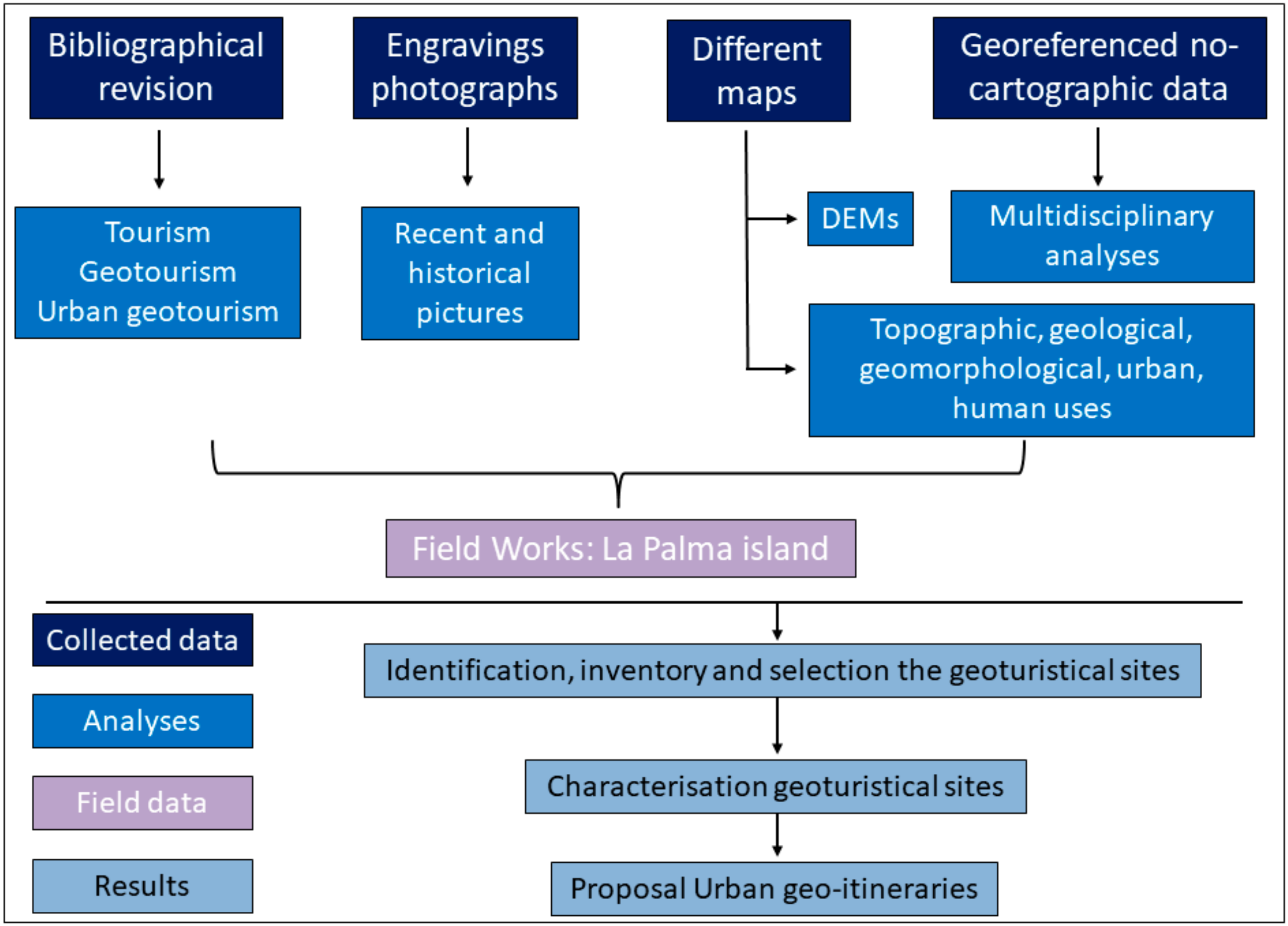
The methodology used in this study follows that used in similar studies [27,54,55,58]. Potential geomorphological sites are identified, inventoried, classified, and characterized including natural outcrops within and surrounding the urban area. The same process is applied to tangible cultural heritage assets (Figure 1). Once complete, geo-itineraries can be formulated, considering geomorphology and cultural heritage to explain the relationships between urban construction and the landscape over time.
3.1. Geographical, Geomorphological and Historical Context of La Palma
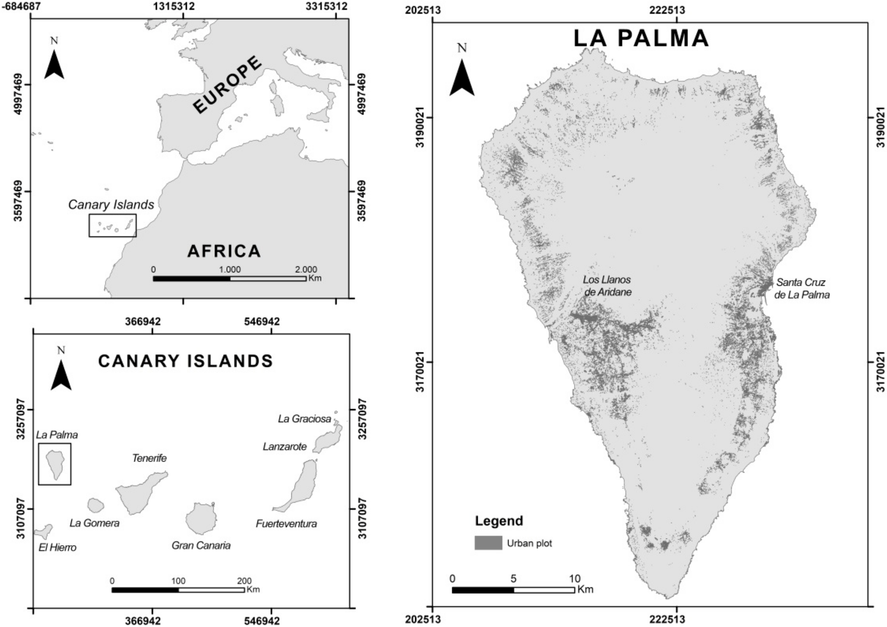
Santa Cruz de La Palma (SCLP) is located on the eastern side of the island (Figure 2). Three main geological units can be identified in SCLP. The oldest units erupted during the construction of the Taburiente Caldera II (or Upper Taburiente), to the north-west of SCLP, approximately 800,000 years ago [59,60]. These units are characterized by effusive eruptive phases [61] and high lava volumes [62]. The middle geological unit is comprised of phreatomagmatic deposits associated with the formation of the Risco de la Concepción volcano. The third geological unit is composed of abundant alluvial deposits from numerous ravines [63], typical geomorphology of the shield volcanoes of the Canary Islands [64]. Geomorphologically, several features of interest can be identified in SCLP. There is a fossil cliff built on basaltic lava with significant colluvial and alluvial deposits. The Risco de la Concepción volcano is a phreatomagmatic (explosive interaction between magma and water) volcano, with intercalated magmatic and submarine explosive materials [65]. Within the crater of the Risco de La Concepción there is a secondary cinder cone, with basaltic cliffs forming part of an urban area developed as SCLP grew towards the sea. Finally, ravines cross the city flow into the sea giving rise to a beach in which alluvial deposits are mixed with “callao” and sand.
In 1493 the Spanish conquest of La Palma ended in the only natural bay, and the government seat was established in the main cave of Carías located to the north of the current Las Nieves ravine. In 1518, the settlement was granted the title of Villa, and in 1542 the title of Muy Noble y Leal Ciudad [66]. SCLP suffered numerous historical difficulties, e.g., the uprising of the Benahoarites or attack by the pirate François Le Clerc in 1553 [67]. Le Clerc conquered SCLP for nine days, until the occupation was put down by the inhabitants themselves who managed to expel the pirate. The resulting fire led to the rebuilding of the Villa. After this event, the government focused on the development of an effective defensive system, building the Santa Catalina Castle, (completed in 1560) as well as other fortresses that have now disappeared [66]. The Villa continued to grow although there were further setbacks such as fires in 1770 and 1798, and flooding from the Las Nieves ravine in 1793. In spite of these catastrophes, the city expanded towards the south, with important cultural seats founded along the Calle Real, El Salvador and La Concepción churches, the City Hall, La Alameda square, and the El Dornajo and Borrero squares. The houses of important historical families such as the Salazar House, were constructed entirely of volcanic stone [68].
Los Llanos de Aridane (LLA) is located on the western side of La Palma (Figure 2) and the town is located in the north-west sector of a giant landslide associated with the Cumbre Nueva collapse [61,62]. Geological units in and around LLA are the marine fan-delta deposits associated with the Barranco of Las Angustias, basaltic lava flows from monogenetic volcanoes of the Cumbre Vieja volcanic rift which have partially filled the collapse, various basaltic cinder cones (Tenisca, Argual and Laurel), and alluvial deposits from the ravines [63]. Several features of prominent geomorphological interest can be identified in the LLA region. To the west of the population center, the deeply incised Barranco de Las Angustias is found to the north, the Pico Bejenado stratovolcano, and to the south of LLA the Tenisca ravine.
After the conquest of La Palma land divisions were established in the Tazacorte ravine and the Argual plain due to the availability of water in this area. The town of Los Llanos de Aridane was then known as Los Llanos de Tazacorte. LLA was founded in 1517, coinciding with the transfer of the patron saint of the town, Nuestra Señora de Los Remedios to its present location. The transfer was agreed in order to locate the church outside the inheritance lands of the lords of Tazacorte and Argual. The new location was established as the main communication route of the island, the royal road linking LLA with Tazacorte [69]. In successive centuries LLA grew around the church Nuestra Señora de Los Remedios, its square (now the Plaza España) and the royal road (today Calle Real), but the economy grew predominantly on the Argual plain, including the manor houses of prominent citizens (e.g., Poggio Maldonado, Vélez de Ontanilla, Massieu Vandale and Monteverde). From these estates, aqueducts and infrastructure were built to channel water from the Barranco de Las Angustias to the main crops of sugar cane [70].
3.2. Tourism on La Palma Island
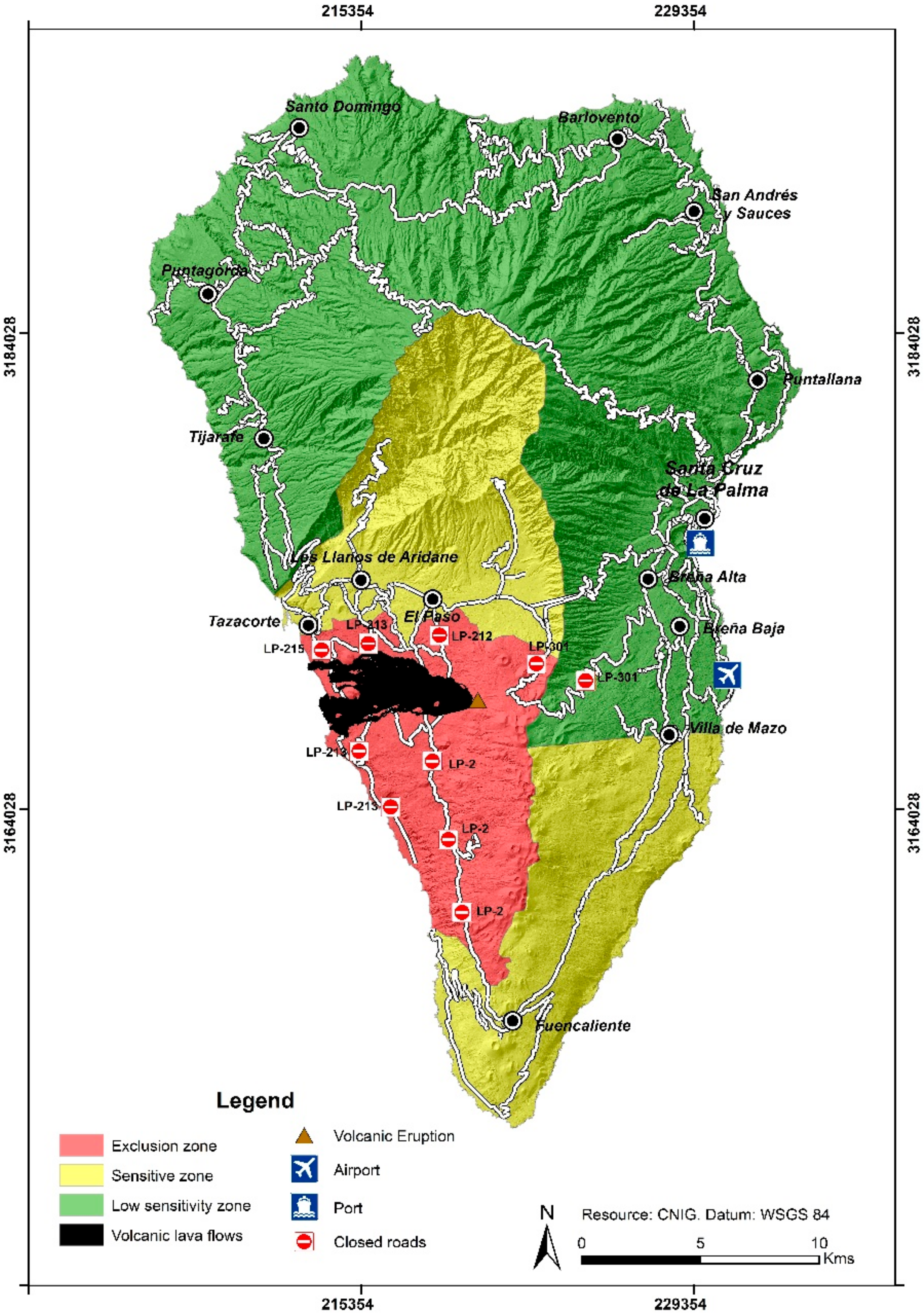
La Palma has opted for an alternative and sustainable tourism model following the directives issues by the UNWTO, in contrast to the sun and beach tourism model of the four largest Canary Islands (Tenerife, Gran Canaria, Fuerteventura and Lanzarote). On La Palma, tourist attractions have been developed around nature including stargazing, hiking and rural tourism [71]. La Palma has been affected by the general global tourism crisis outlined, with the situation compounded by negative effects associated with the 2021 eruption of Tajogaite (Cumbre Vieja). The eruption began on 19 September and ended on 13 December, interrupting the traditional high season for international tourism on the island. Currently, the aftermath of the eruption continues to affect tourism, as the popular tourist center of Puerto Naos remains closed due to the high concentrations of toxic gases [72].
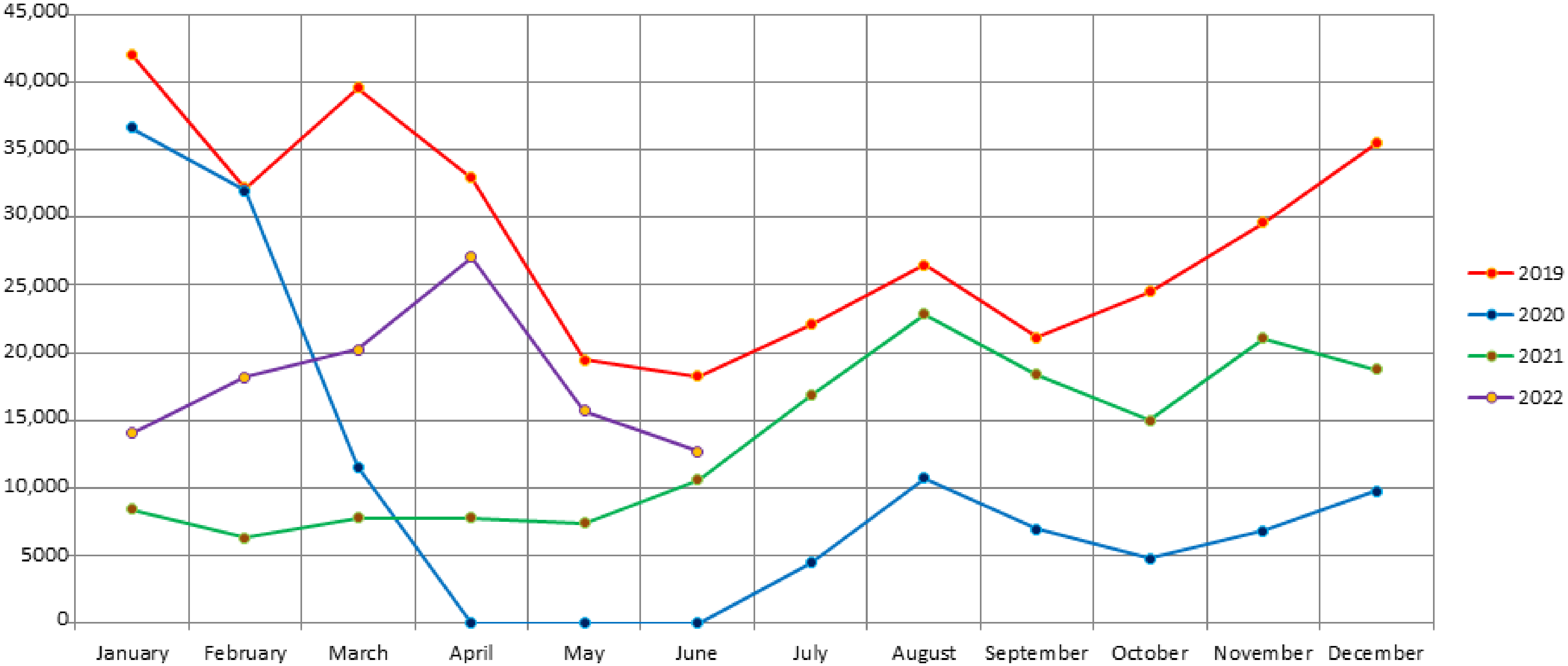
Tourism evolution over the “crisis” period began with a normal year in 2019, marked by the international tourism season from October to April, and the national tourism season from June to September (Figure 3). In 2020, tourist numbers decreased sharply during March to May the months of Spain’s COVID-19 lockdown. In 2021, recovery of the tourism sector began despite the ongoing pandemic status. From September 2021 onwards the number of tourists again decreased in comparison to a normal year, coinciding with the onset of the Tajogaite volcanic eruption. Although published data on tourism are not sufficient to establish a definite trend for 2022, between January and June the number of tourists was 59% lower than over the same period in 2019 (Figure 3). This was partly related to the closure of Puerto Naos the main visitor hub tourist center of the island. This closure is hindering the recovery of tourism due to a shortage of accommodation places.
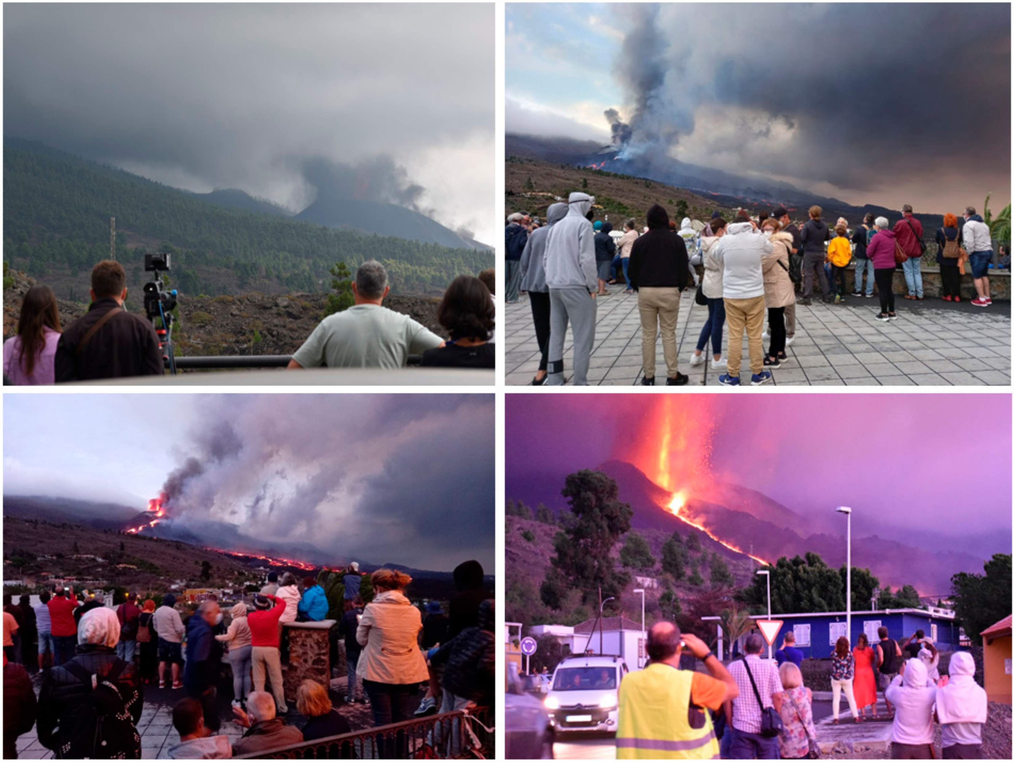
Active volcanoes represent a significant potential hazard for nearby societies. The eruption of Tajogaite has been devastating for the local populations with the destruction of thousands of homes, crops, equipment, and infrastructure. However, volcanic regions also generate socio-economic opportunities [73,74,75,76] and millions of people live on and around active volcanoes around the world [77,78] in order to take advantage of the variety of resources available (soils, building materials, geothermal energy, tourism and others) [73]. Tourism is one of the greatest resources volcanoes can offer [73,74,75,76,79], which was evident in La Palma when tourist arrivals recovered slightly from mid-October to mid-December 2021 (Figure 3). International visitors (tourists, students, photographers, journalists, scientists) came to the very-accessible island to observe the live volcanic eruption (Figure 4). The same situation has also been observed in other recent eruptions, e.g., of Iceland 2021 and 2022, and Hawaii in 2018 [80,81,82]. Therefore, it is evident that an erupting volcano is a very powerful attraction for tourists [73,83] with attractions including scenery, the spectacle of volcanic activity, hot springs and spas, climbing and skiing on volcanoes, ecology and adventure travels, black, red and green sand beaches, archeology and religion [73]. With this in mind, a positive relationship can be established between volcanoes and tourism beyond simple observation and view of the space of the eruption and areas directly affected by the ash, pyroclasts and lava flows of Tajogaite 2021. By identifying places of interest for geotourism in SCLP and LLA, it is possible to design and implement urban geotourism itineraries that diversify the leisure offer on the island, helping to reduce the negative effects of the volcanic eruption by contributing to the island’s economy.
These two cities were chosen for the design of urban geotourism itineraries because they are the two most populated municipalities on the island, accounting for more than 43% of the total 83,380 inhabitants of La Palma [3]. They are the main economic centers of La Palma and they have a rich variety of landforms (cinder cones, lava flows, ravines, cliffs, beaches, deposits) and an intangible cultural heritage. Both LLA and SCLP were directly or indirectly affected during the 2021 eruption. These factors indicate both areas are ideal for the development of the first urban geotourism itineraries, according to the geographical approach of geotourism [8].
3.3. Fieldwork: Inventory and Selection of Urban Geoheritage
An inventory of urban geoheritage is a fundamental source for urban geotourism development [47] and fieldwork is an integral part of this [84,85]. The criteria for the selection of the sites were that they should all be representative of the geoheritage and cultural heritage of the cities, accessible and preserved. In order to collect comprehensive information, a card was developed based on previous models, to allow a complete inventory and assess the value potential of the tourist attractions [86]. Specificities have been incorporated for the design of geo-urban itineraries in volcanic areas [54,87,88]. The card is subdivided into three main sections. The first displays the location of the resource/attraction with UTM coordinates (28N, datum WGS84), a map of its location and whether the ownership is public or private (this affects the proposed geotourism use). The second section allows characterization and description of the site, including resources/attractions, interest for geotourism, photographs, accessibility, tourist infrastructure, complementary activities, degree of management, state of conservation, the current level of use, tourist routes or circuits in which the site may be included, conflicts of use and relationship with other attractions in the immediate environment. The final section is dedicated to observations, data and bibliographical references than can aid characterization of the site. Most of the information for the card is obtained in the field, with some desk-based information compilation.
4. Results
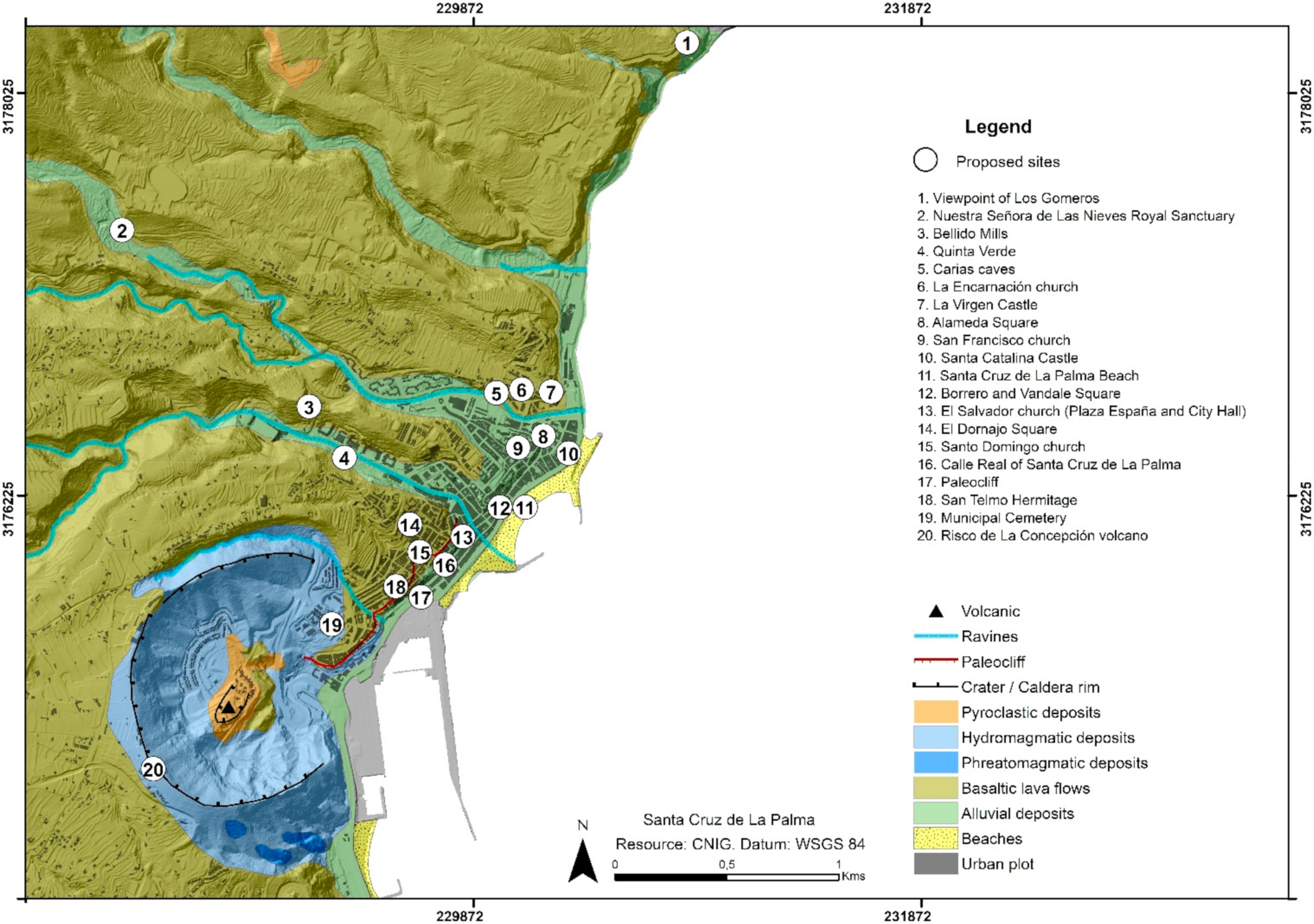
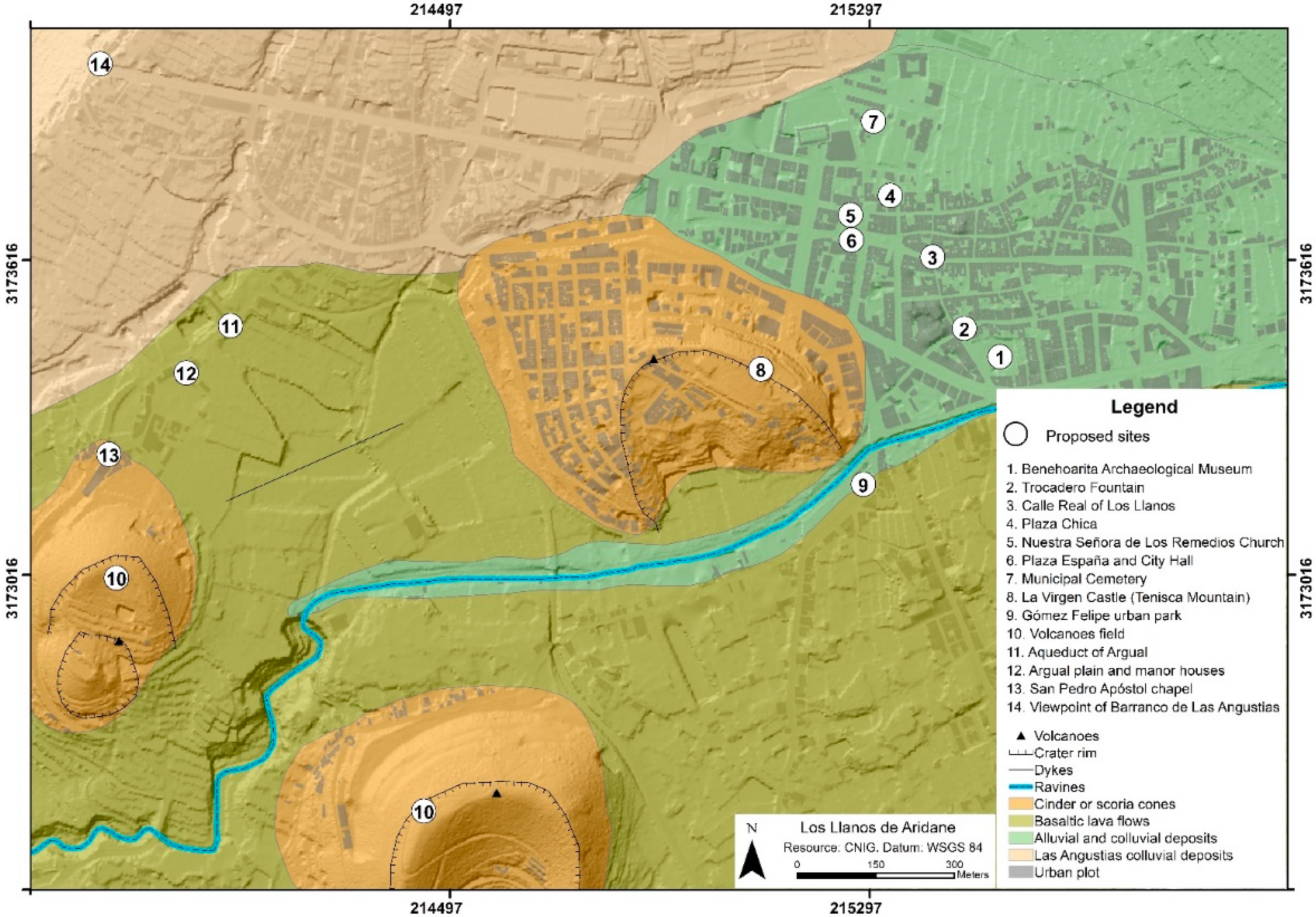
A total of 34 sites have been selected and studied across the regions of SCLP (20 sites) (Figure 5) and LLA (14 sites) (Figure 6) (Table 1). Sites have been grouped according to their natural and cultural heritage. Natural heritage has been further divided into direct volcanic formations, and those resulting from volcanic process including erosion and accumulation. Cultural heritage has been divided into civil, military, and religious categories.
4.1. Geoheritage in SCLP and LLA
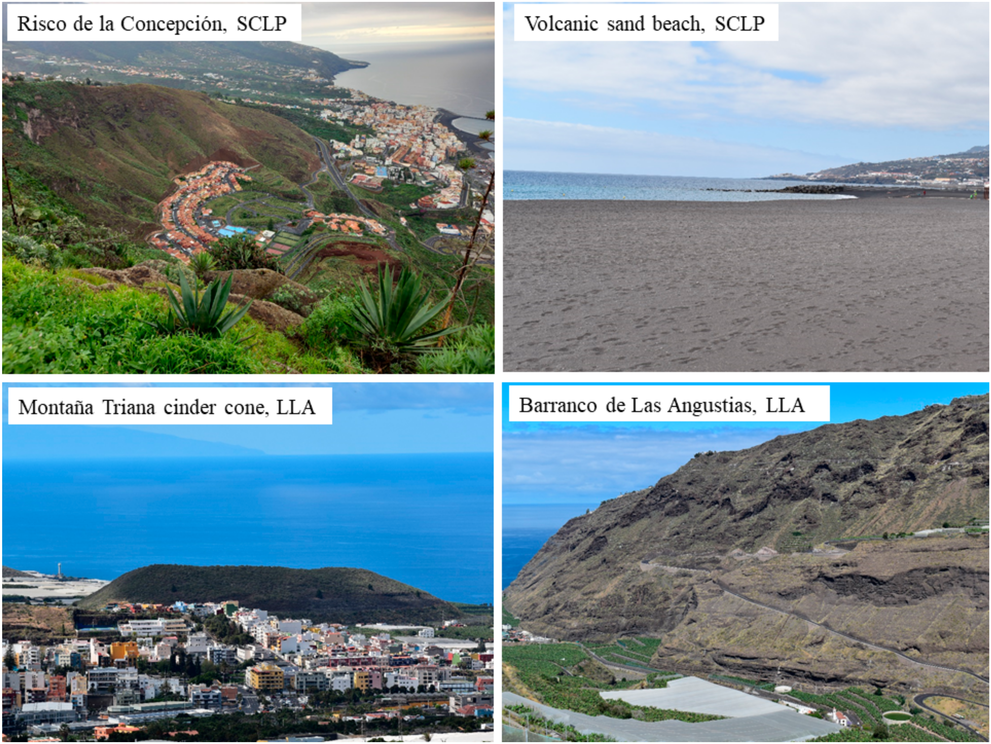
The natural heritage of both SCLP and LLA is associated with local volcanic relief and subsequent processes of erosion and accumulation. This heritage is present in the population centers and their surrounds because they have not been destroyed by human activity over time and can provide a view of the volcanic landscape before human occupation (Figure 7).
The volcanic geoheritage in SCLP and LLA is directly associated with volcanic eruptions. The volcanic rifts, cinder cones, hydromagmatic cones, calderas, lava fields and other minor volcanic landforms. The volcanic complex of the Risco de La Concepción (SCLP) is striking, first constructed as a hydromagmatic cone and later activity forming a cinder cone with lava flows. In the LLA, the five cinder cones and lava fields of Montaña de Tenisca, Montaña de Argual, Montaña de Triana, Montaña de La Laguna and Montaña de Tacande are noteworthy for their scenic interest. Both of these examples are already protected as Natural Monuments.
The forms of erosion or accumulation in the study areas are related to the interplay between the torrential rainfall, marine and slope dynamics processes. Erosion carves out ravines and cliffs, while accumulation forms beaches, alluvial and colluvial deposits. Among the former are the numerous ravines that erode the basaltic lava flows and sedimentary deposits of the Cumbre Nueva, which can be found in both SCLP and LLA. The most striking ravine of geomorphological size and interest and the landscape is the Barranco de Las Angustias, which forms a geological unit of its own in LLA. Associated with marine erosion are the cliffs in SCLP carved through lava flows, with both active and fossil cliff formations. The main forms associated with sedimentary processes form alluvial deposits in the Barranco de Las Angustias in LLA, and the volcanic black sand beaches in SCLP.
4.2. Urban Cultural Heritage
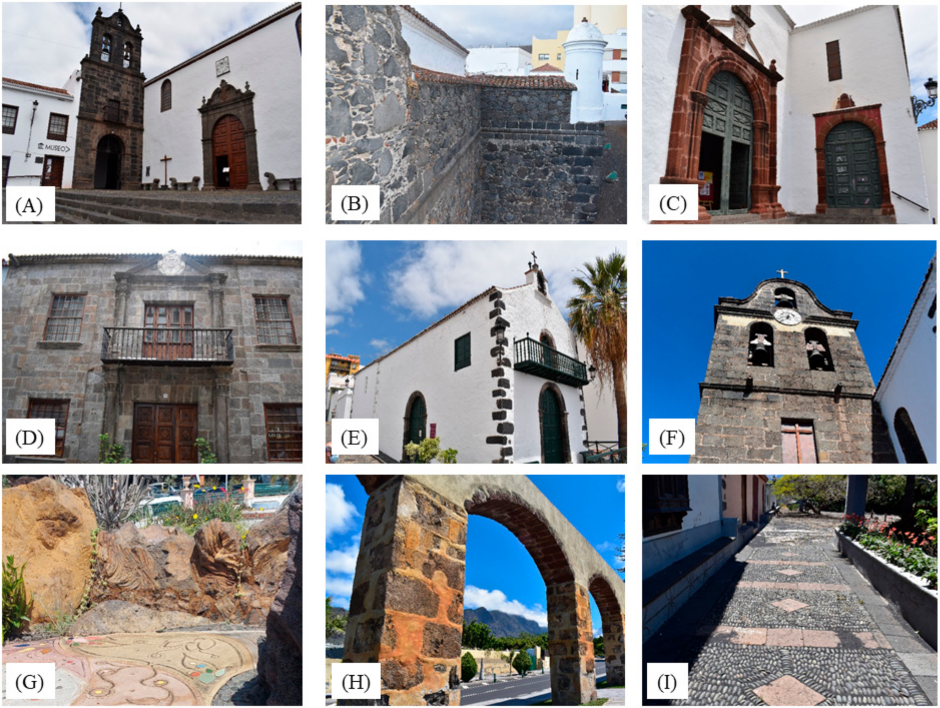
In accordance with the geographic approach of geotourism [8], the tangible cultural heritage examined includes urban plans, squares, houses, castles, walls, walls of terraces, churches, chapels, convents, etc., that were created by the inhabitants and passed on to future generations. This cultural heritage is formed of distinctive features through history and societal interactions, so the concept of urban cultural heritage is similar to the definition provided by UNESCO [89]. The different elements of the cultural heritage areas in SCLP and LLA can be grouped according to the function and purpose for which they were created: civil, military, and religious heritage (Figure 8).
The civil heritage of SCLP and LLA, is made up of elements of historical interest, but for inclusion here the presence of volcanic stones is fundamental to their construction and decoration. Other civil heritage elements are associated with urban planning such as the location of SCLP in a natural bay on the coast, or LLA in a sedimentary plain where volcanoes close off part of the runoff. Still other examples include: cobblestones; streets using basalts and ignimbrites (Calle Real in SCLP); archaeological elements (Benahoarita Archaeological Museum); domestic architecture built using blocks of basaltic lava, ignimbrites, red scoria, hydromagmatic materials, boulders, etc. (Salazar House); the squares (La Alameda square, Borrero square, Vandale square, El Dornajo square, Plaza Chica, Plaza España); the parks (Gómez Felipe urban park); the mills (Bellido Mills) and aqueducts (Aqueduct of Argual).
Military heritage is comprised of engineering works that were created for the defense and protection of the population and witnessed or commemorate war events of the past. Among these types of constructions are castles, fortifications, military batteries, military museums, or military palaces. In La Palma, military heritage is only represented by the Santa Catalina Castle in SCLP. It is located on the coast and its function was to defend the city from attacks from the sea [66]. It was built using basaltic boulders and blocks from the ravines and beaches.
Religious heritage is comprised of historical constructions built for this purpose, and those linked to religious festivals or belonging to the ecclesiastical authorities. This type of heritage includes churches, hermitages, convents, and cemeteries. To be considered under urban geotourism, religious heritage also requires the use of volcanic stone (volcanic: lavas, tuffs, ignimbrites or hydromagmatic materials, erosion and accumulation derived: ravine and beach “callao”) as key to their construction and decoration. Religious heritage in SCLP includes Nuestra Señora de Las Nieves Royal Sanctuary, La Encarnación church, San Francisco church, El Salvador church, the church and convent of Santo Domingo, San Telmo hermitage, La Virgen Castle and the Municipal Cemetery. In LLA, this type of heritage is represented by the Nuestra Señora de Los Remedios church, San Pedro Apóstol hermitage, La Virgen Castle and the Municipal Cemetery.
5. Discussion
Geotourism has significant implications for tourism diversification, but it has only recently been put into practice. Urban geotourism is increasing, but it is not established like the more obvious form of consolidated geotourism in natural areas. The geological and geomorphological influence on cities is evident [27,31,37,40,46,47,49,50]; even so, most research focuses on geosites, geomorphosites and geo-routes in natural areas [6,7,8,9,10,11,12,13,15,16]. The presence of geographic features conditions town planning and human activities [90], or the natural outcrops near the cities are used to provide materials for the construction of buildings and infrastructures [46]. SCLP is located in a coastal strip constrained by numerous ravines that flow into the sea, giving rise to black sand beaches, while its western expansion is constrained by the phreatomagmatic Risco de la Concepción volcano. In LLA the city is constrained by the Barranco de Las Angustias, and the interplay of big sedimentary deposits and the volcanic areas of the Aridane Valley, which have given rise to a relatively flat and ideal surface for emplacement and expansion of the city.
The choice of SCLP and LLA as cities for geotourism sites (including the design of urban geotourism itineraries) for the first time is based on several aspects. Firstly, these are the two main population centers of the island and together, host more than 43% of the island’s population. Secondly, they have contrasting geological and geomorphological contexts, allowing the selection of diverse and representative sites throughout the topography of La Palma. SCLP is located in the oldest geological units of La Palma, associated with shield volcanism of the Taburiente volcano [62]. LLA is located in the area of recent and historical volcanism, including the Bejenado stratovolcano and Cumbre Vieja volcanic rift [59,60] Thirdly, both regions have a rich and varied tangible cultural heritage asset of civil, military and religious buildings, which were built and decorated with a wide variety of volcanic rocks, representing the history of each city and the geological and geomorphological context of its location. SCLP and LLA are the main socioeconomic centers of the island; offering new tourist products contributes to diversifying the leisure offer, on the island and can contribute to economic redevelopment of La Palma after the negative effects of the Tajogaite 2021 eruption.
Due to the volcanic origin of La Palma, volcanic landforms and rocks dominate most of the selected natural and cultural heritage attractions of SCLP and LLA, therefore, much of the construction used basaltic materials (lava flows, lapilli, scoria, etc.). However, the origin of the materials does not always correspond to the proximity of the outcrops and quarries [66,67]. Although most modest and ancient buildings use, local stone because it was cheaper to transport, more noble buildings such as churches used, the “best” and more extensive stone [44,67], transported from around the island, from places with special meaning, or from other islands [91]. An example is the El Salvador church in SCLP, built using stone from the current Barranco de Las Nieves or possibly from Pico Birigoyo [92], several kilometers away from the city. Building stone was also brought from other islands such as La Gomera: El Salvador church, the Casas Consistoriales or for important family houses such as the Nicolás Massieu property in SCLP [68]; or Tenerife: paving slabs in the Calle Real of SCLP [93]. In spite of these specific examples, most building stone used in the heritage buildings of SCLP and LLA was local. LLA building stone came from nearby ravines or places such as the Montaña Tenisca cinder cone, or the Llano de La Virgen near Argual [94]. Extraction of building stone from nearby places for the construction and decoration of buildings was common practice [28,41,43,47,48,50,82,91].
A central activity of general urban geotourism is the observation and study of the diversity of materials used in different types of buildings across selected regions [47,50], where often the presence of fossils is important [95]. However, in entirely volcanic territories the diversity of materials is less and the presence of fossils is unusual [22]. This may be the reason for the underdevelopment of urban geotourism in volcanic areas compared to towns in other geological/geomorphological contexts [38,96,97,98,99,100]. However, there are examples of urban geotourism routes and itineraries in volcanic terrains, regionally in Tenerife: Puerto de La Cruz, Icod de Los Vinos or Garachico [54,87,101]; nationally in Ciudad Real [102]; internationally in cities such as Rome and Naples in Italy, Cidade Velha in Cape Verde, examples in Mexico City, Clermont-Ferrand in France, or southern Brazil [37,49,88,103,104,105,106].
Of the 34 sites selected here 20 are found in SCLP and 14 in LLA. Twenty are categorized as natural heritage and are further divided between volcanic landforms (3 sites) and erosion and accumulation features (2 sites). A total of 29 sites can be categorized as tangible cultural heritage assets, divided between civil (17 sites), military (1 site) and religious (11 sites) heritage. The proposed urban geo-itineraries are open although spatially themed due to the small size of the cities and the proximity of the selected sites. The tourist decides how and when to follow the itinerary, e.g., following the layout of the coastline in SCLP, looking for specific landforms such as volcanoes in LLA, or following a street with significant attractions.
This is an applied study that aims to diversify La Palma’s tourism offer and reinforce the tourism model [107], based on promoting products and experiences associated with volcanic attractions of the island, following the sustainable principles advocated by the UNWTO. The 2021 Tajogaite eruption presents a unique opportunity for the islands tourist industry to take advantage of. This has been recognized by the different tourism stakeholders on La Palma who, during the eruption, developed an island-wide tourism map to assist tourists in travelling to many parts of the island (Figure 9).
6. Final Remarks and Perspectives
Geomorphological landforms and processes have enormous potential as a tourism resource. Public and private tourism managers can use these as an opportunity to diversify into geotourism policies, both in natural environments and urban areas. Such policies respond to the increasing demand for informed and sustainable tourism and can aid in the response to tourist exhaustion identified in mature destinations. La Palma has historically included the volcanic landscape, the night sky and rural tourism among its resources. However, the eruption in 2021 has highlighted the attraction of landforms for the tourist, despite the negative effects of the volcano on the population and the territory. Creating geo-itineraries exploits the natural outcrops and cultural assets in a sustainable way and is a key tool for interpretation and dissemination of the natural and cultural heritage. This work identifies natural or cultural places of geotourism interest in SCLP and LLA, in line with UNWTO proposals.
In spite of the recent and innovative nature of urban geotourism, the proposal to identify attractions to create geo-itineraries is consolidating as a good way to exploit tourist potential that the landforms present in the natural outcrops of cities or their tangible heritage assets, while they are a key tool in the interpretation and dissemination of the natural and cultural heritage of cities and their environments.
Urban geotourism is still an emerging practice being implemented gradually. In order to create tools to identify the value of geosites and geomorphosites, further research and development is needed. The catalog of spaces for urban geotourism can then be developed, diversifying the geological and geomorphological contexts of the sites. It is also necessary to monitor the success of geo-itineraries, using a consistent method of evaluation for suitability and proposed improvements. Interviewing stakeholders and conducting surveys together with secondary statistical information on the movement of people and revenue are key to successful evaluation.
Author Contributions
Conceptualization, W.H., J.D.-P. and N.M.P.; methodology, W.H. and J.D.-P.; Geographical Information Systems, W.H.; investigation, W.H., J.D.-P. and N.M.P.; writing—original draft preparation, W.H.; writing and editing, W.H. and J.D.-P.; review, W.H., J.D.-P. and N.M.P.; supervision, J.D.-P. and N.M.P.; project administration and funding acquisition, J.D.-P. and N.M.P.; All authors have read and agreed to the published version of the manuscript.
Funding
This research was supported by project “VOLTURMAC, Fortalecimiento del volcano turismo en la Macaronesia (MAC2/4.6c/298)”, which co-finances the Cooperation Program INTERREG V-A Spain-Portugal MAC (Madeira-Azores-Canarias) 2014-2020.
Institutional Review Board Statement
Not applicable.
Informed Consent Statement
Not applicable.
Acknowledgments
The authors are grateful to four anonymous reviewers for precious suggestions and comments that have contributed to the improvement of this article.
Conflicts of Interest
The authors declare no conflict of interest.
References
- World Tourism Organization. Available online: https://unwto.org/ (accessed on 22 June 2022).
- Álvarez, A. El ciclo de la vida de los destinos turísticos litorales. In Turismo y Territorio en la Ciudad Globalizada; Álvarez, A., Hernández, J., Simancas, M., Eds.; La Laguna: Ayuntamiento de Adeje—Instituto Pascual Madoz—Universidad Carlos III: Canary Island, Spain, 2004; pp. 123–155. [Google Scholar]
- Instituto Canario de Estadística. Available online: http://www.gobiernodecanarias.org/istac/ (accessed on 22 June 2022).
- Simancas, M.; Hernández, R.; Padrón, N. Turismo Pos-COVID-19; Universidad de La Laguna, Cátedra de Turismo CajaCanarias-Ashotel: Canary Island, Spain, 2020; p. 802. [Google Scholar]
- Wang, L.; Tian, M.; Wen, X.; Zhao, L.; Song, J.; Sun, M.; Wang, H.; Lan, Y.; Sun, M. Geoconservation and geotourism in Arxan-Chaihe Volcano Area, Inner Mongolia, China. Quat. Int. 2014, 349, 384–391. [Google Scholar] [CrossRef]
- Ruban, D. Geotourism-A geographical review of the literature. Tour. Manag. Perspect. 2015, 15, 1–15. [Google Scholar] [CrossRef]
- Ólafsdóttir, R.; Tverijonaite, E. Geotourism: A systematic literature review. Geosciences 2018, 8, 234. [Google Scholar] [CrossRef]
- Dowling, R.; Newsome, D. Geotourism: Definition, characteristics and international perspectives. In Handbook of Geotourism; Dowling, R., Newsome, D., Eds.; Edward Elgar Publising Limited: Cheltenham, UK, 2018; pp. 1–22. [Google Scholar]
- Global Geoparks Networks, International Association on Geoparks. Available online: https://globalgeoparksnetwork.org/ (accessed on 22 June 2022).
- Hose, A. Selling the story of Britain’s stone. Environ. Interpret. 1995, 10, 16–17. [Google Scholar]
- Hose, A. Towards a history of geotourism: Definitions, antecedents and the future. Geol. Soc. Lond. Spec. Publ. 2008, 300, 37–60. [Google Scholar] [CrossRef]
- Newsome, D.; Dowling, R. Geotourism: The Tourism of Geology and Landscape; Goodfellow Publishers: Oxford, UK, 2010; p. 320. [Google Scholar]
- Carcavilla, L.; Belmonte, A.; Durán, J.; Hilario, A. Geoturismo: Concepto y perspectivas en España. Enseñanza De Las Cienc. De La Tierra 2011, 19, 81–94. [Google Scholar]
- Tourtellot, J.B. Geotourism for Your Community: A Guide for a Geoturism Strategy; National Geographic: Washington, DC, USA, 2006. [Google Scholar]
- Stoke, A.M.; Cook, S.D.; Drew, D.; Travel Industry Association of America; National Geographic Traveler. Geotourism: The New Trend in Travel; Travel Industry Association of America: Washington, DC, USA, 2003. [Google Scholar]
- Pralong, J.P. Geotourism: A new form of tourism utilizing natural landscapes and based on imagination and emotion. Tour. Rev. 2006, 61, 20–25. [Google Scholar] [CrossRef]
- National Geographic. Available online: www.nationalgeographic.com/maps/geotourism/geotourism-principles/ (accessed on 22 June 2022).
- European Geoparks. Available online: http://www.europeangeoparks.org/?p=223 (accessed on 22 June 2022).
- Millán, M. La función didáctica del geoturismo. Propuesta para la Región de Murcia. Gran Tour Rev. De Investig. Turísticas 2011, 4, 62–93. [Google Scholar]
- Olson, K.; Dowling, R. Geotourism and Cultural Heritage. Geoconserv. Res. 2018, 1, 37–41. [Google Scholar] [CrossRef]
- Sánchez-Cortez, J.; Simbaña-Tasiguano, M. Los Geoparques y su implantación en América Latina. Estud. Geogr. 2018, 79, 445–467. [Google Scholar] [CrossRef]
- Dóniz-Páez, J.; Hernández, W.; Przeor, M.; Pérez, N. Guía Geoturística de Tenerife; Involcan: Santa Cruz de Tenerife, Spain, 2019; p. 113. [Google Scholar]
- Kubalíková, L. Assessing Geotourism Resources on a Local Level: A Case Study from Southern Moravia (Czech Republic). Resources 2019, 8, 150. [Google Scholar] [CrossRef]
- Dowling, R. Global geotourism: An emerging form of sustainable tourism. Czech J. Tour. 2013, 2, 59–79. [Google Scholar] [CrossRef]
- Chen, A.; Lu, Y.; Ng, Y. Principles of Geotourism; Springer: Berlin/Heidelberg, Germany, 2015; p. 264. [Google Scholar]
- Chen, A.; Ng, Y.; Zhang, E.; Tin, M. Dictionary of Geotourism; Springer: Singapore, 2020; p. 732. [Google Scholar]
- Reynard, E.; Pica, A.; Coratza, P. Urban geomorphological heritage. An overview. Quaest. Geogr. 2017, 36, 7–20. [Google Scholar] [CrossRef]
- Díaz-Martínez, E.; Guillén-Mondéjar, F.; Brilha, J.; Monge-Ganuzas, N.; Herrero Martínez, N.; Hilario, A.; Mata-Perelló, J.; Meléndez, G.; Utie, J. Nuevas resoluciones y avances de la UICN para la geoconservación. In Patrimonio Geológico, Gestionando la Parte Abiótica del Patrimonio Natural; IGME: Madrid, Spain, 2017; pp. 247–252. [Google Scholar]
- Kubalíková, L.; Drápela, E.; Karel, K.; Aleš Bajer, K.; Balková, M.; Kuda, F. Urban geotourism development and geoconservation: Is it possible to find a balance? Environ. Sci. Policy 2021, 121, 1–10. [Google Scholar] [CrossRef]
- Reynard, E.; Kaiser, C.; Martin, S.; Regolini, G. An application for Geosciences communication by smartphones and tablets. In Engineering Geology for Society and Territory; Lollino, G., Ed.; Springer International Publishing: Cham, Switzerland, 2015; Volume 8, pp. 265–268. [Google Scholar]
- Wolniewicz, P. Classification and Quantification of Urban Geodiversity and Its Intersection with Cultural Heritage. Geoheritage 2022, 14, 63. [Google Scholar] [CrossRef]
- Pelfini, M.; Brandolini, F.; D’Archi, S.; Pellegrini, L.; Bollati, I. Papia civitas gloriosa: Urban geomorphology for a thematic itinerary on geocultural Heritage in Pavia (Central Po Plain, N Italy). J. Maps 2020, 17, 1–9. [Google Scholar] [CrossRef]
- Caetano, P.; Almeida-Serra, M.; Moreira, M. Entre a superficie e o subterraneo: Proposta de percursos geoturísticos urbanos em Lisboa. In Proceedings of the International Conference on Tourism and Management Studies, Algarve, Portugal, 26–29 October 2011; pp. 426–437. [Google Scholar]
- Díez-Herrero, A.; Vegas-Salamanca, J.; Peña-González, B.; Herrero-Ayuso, S.; Lucía-Atance, R.; Santos-Borreguero, C. Geoturismo en la ciudad de Segovia: Complemento y alternativa al turismo tradicional. In Avances y Retos en la Conservación del Patrimonio Geológico en España; Fernández-Martínez, E., Castaño de Luis, R., Eds.; Universidad de León: Madrid, Spain, 2011; pp. 104–108. [Google Scholar]
- Liccardo, A.; Mantesso-Neto, V.; Piekarz-Gil, F. Geoturismo Urbano, Educação e Cultura. Anu. Inst. Geocienc. 2012, 5, 133–141. [Google Scholar] [CrossRef]
- Tavallaei, S.; Rashidi Ebrahim Hesari, A.; Fathi, M.H.; Farzaneh, M.; Mousavi, S.C. The evaluation of the geo-tourism for urban development: A case study in Ajabshir city, Iran. J. Civ. Eng. Urban. 2012, 2, 80–85. [Google Scholar]
- Del Monte, M.; Fredi, P.; Vergari, F.; Pica, A. Geosites within Rome City center (Italy): A mixture of cultural and geomorphological heritage. Geogr. Fis. Din. Quat. 2013, 36, 241–257. [Google Scholar]
- Aparecida Del Lama, E.; De La Corte Bacci, D.; Martins, L.; da Gloria Motta García, M.; Kazumi, L. Urban Geotourism and the Old Centre of São Paulo City, Brazil. Geoheritage 2015, 7, 147–164. [Google Scholar] [CrossRef]
- Pica, A.; Vergari, F.; Fredi, P.; Del Monte, M. The Aeterna Urbs Geomorphological Heritage (Rome, Italy). Geoheritage 2016, 8, 31–42. [Google Scholar] [CrossRef]
- Comănescu, L.; Nedelea, A.; Stănoiu, G. Geomorphosites and geotourism in Bucharest city center (Romania). Quaest. Geogr. 2017, 36, 51–61. [Google Scholar] [CrossRef]
- De Wever, P.; Baudin, F.; Pereira, D.; Cornée, A.; Egoroff, G.; Page, K. The importance of geosites and heritage stones in cities—A review. Geoheritage 2017, 9, 561–575. [Google Scholar] [CrossRef]
- Aparecida Del Lama, E. Potential for Urban Geotourism: Churches and Cemeteries. Geoheritage 2018, 11, 1717–1728. [Google Scholar] [CrossRef]
- Erikstad, L.; Nakrem, H.A.; Markussen, J.A. Protected Geosites in an Urban Area of Norway, Inventories, Values, and Management. Geoheritage 2018, 10, 219–229. [Google Scholar] [CrossRef]
- Habibi, T.; Ponedelnik, A.; Yashalova, N.; Ruban, D. Urban geoheritage complexity: Evidence of a unique natural resource from Shiraz city in Iran. Resour. Policy 2018, 59, 85–94. [Google Scholar] [CrossRef]
- Brocx, M.; Semeniuk, V. Building Stones Can Be of Geoheritage Significance. Geoheritage 2019, 11, 133–149. [Google Scholar] [CrossRef]
- Brzezińska-Wójcik, T.; Skowronek, E. Tangible Heritage of the Historical Stonework Centre in Brusno Stare in the Roztocze Area (SE Poland) as an Opportunity for the Development of Geotourism. Geoheritage 2020, 12, 10. [Google Scholar] [CrossRef]
- Faccini, F.; Giardino, M.; Paliaga, G.; Luigi Perotti, L.; Brandolini, P. Urban geomorphology of Genoa old city (Italy). J. Maps 2020, 17, 51–64. [Google Scholar] [CrossRef]
- Górska-Zabielska, M.; Zabielski, R. Stone and urban space—Its potential to promote geotourism. GeoJ. Tour. Geosites 2019, 26, 1033–1045. [Google Scholar] [CrossRef]
- Aparecida Del Lama, E.; Costa, A.G. Global Heritage Stones in Brazil. Geoheritage 2022, 14, 25. [Google Scholar] [CrossRef]
- Vergari, F.; Pica, A.; Melelli, L.; Del Monte, M. Geomorphological classification of the landscape in urban areas: Hints from some study cases in Italy. Rend. Online Soc. Geol. Ital. 2022, 57, 33–39. [Google Scholar] [CrossRef]
- Cárdenes, V.; Cabrera-Guillén, D.; López-Piñeiro, S.; Rubio Ordóñez, A. The Historical Significance of the Welded Tuffs from Arucas, Canary Islands. Geoheritage 2022, 14, 46. [Google Scholar] [CrossRef]
- Rodrigues, M.L.; Machado, C.; Freire, E. Geoturism routes in urban areas: A preliminary approach to the Lisbon geoheritage survey. GeoJ. Tour. Geosites 2011, 2, 281–294. [Google Scholar]
- Lacreu, H.; Sosa, G.; Casali, N.; Martínez, A.; Merlo, M.; Díaz-Mayo, A.; Gómez, F.; Belpoliti, N.; Martínez, R. Paseos geológicos urbanos. Fundam. Humanid. 2012, 13, 285–297. [Google Scholar]
- Dóniz-Páez, F.; Quintero Alonso, C. Propuesta de rutas de geoturismo urbano en Icod de Los Vinos (Tenerife, Islas Canarias, España). Cuad. Geogr. 2016, 55, 320–343. [Google Scholar]
- Dóniz-Páez, F.J.; Becerra-Ramírez, R.; Carballo-Hernández, M. Propuesta de itinerario geoturístico urbano en Garachico (Tenerife, Canarias, España). Investig. Geogr. 2016, 66, 95–115. [Google Scholar] [CrossRef]
- Fernández-Martínez, E.; Barbadillo, P.; Castaño De Luis, R.; Marcos, A.; Preciado, J.; Serrano, E. Geoturismo en la Ciudad de Burgos: Una Guía de Geología Urbana para Todos los Públicos; Excelentísimo Ayuntamiento de Burgos: Burgos, Spain, 2012. [Google Scholar]
- Fernández-Martínez, E.; Castaño De Luis, R. Geoturismo en la ciudad de Burgos. In Patrimonio Geológico un Recurso para el Desarrollo; Vegas, J., Salazar, A., Díaz-Martínez, E., Marchán, C., Eds.; IGME: Madrid, Spain, 2013; pp. 55–65. [Google Scholar]
- Vegas, J.; Díez-Herrero, A. An Assessment Method for Urban Geoheritage as a Model for Environmental Awareness and Geotourism (Segovia, Spain). Geoheritage 2021, 13, 27. [Google Scholar] [CrossRef]
- Guillou, H.; Carracedo, J.C.; Day, S.J. Dating of the upper Pleistocene-Holocene volcanic activity of La Palma using the unspiked K-Ar technique. J. Volcanol. Geotherm. Res. 1998, 86, 137–149. [Google Scholar] [CrossRef]
- Carracedo, J.C.; Day, S.; Guillou, H.; Gravestock, P. Later stages of volcanic evolution of La Palma, Canary Islands: Rift evolution, giant landslides, and the genesis of the Caldera de Taburiente. Geol. Soc. Am. 2016, 111, 755–768. [Google Scholar] [CrossRef]
- Padrón González, E. Emisión Difusa de Dióxido de Carbono y Otros Volátiles en el Volcán Cumbre Vieja, La Palma, Islas Canarias. Ph.D. Thesis, Facultad de Ciencias Químicas de Universidad de la Laguna, San Cristóbal de La Laguna, Spain, 2008. [Google Scholar]
- Carracedo, J. Los Volcanes de las Islas Canarias; Editorial Rueda: Madrid, Spain, 2008; Volume 4, p. 213. [Google Scholar]
- Barrera Morate, J.L.; García Moral, R. Mapa Geológico de Canarias. Memoria General; GRAFCAN Ediciones: Santa Cruz de Tenerife, Spain, 2011; p. 502. [Google Scholar]
- Romero Ruiz, C.; Dóniz-Páez, F.J. Los relieves volcánicos españoles. In Mapa Geomorfológico de España y del Margen Continental, Escala 1.1000.000; Martín Serrano, A., Ed.; Ministerio de Educación y Ciencia: Madrid, Spain; IGME: Madrid, Spain, 2005; pp. 159–172. [Google Scholar]
- Quesada, M.L.; Alonso, J.J.; de la Nuez, J. Evolución submarina-subaérea del edificio hidromagmático de la Caldereta (La Palma, Canarias). In Proceedings of the II Congreso Geológico de España, Granada, Spain; 1988; pp. 377–386. [Google Scholar]
- Martín González, M.A. La historia de Santa Cruz de La Palma; Centro de la Cultura Popular Canaria: Tenerife, Spain, 1999; p. 173. [Google Scholar]
- Aznar Vallejo, E.; Bello León, J. Discurso y Plantas de Las Yslas de Canaria; Ediciones del Cabildo de Gran Canaria: Gran Canaria, Spain, 1999; p. 101. [Google Scholar]
- Pérez García, J. Casas y Familias de Una Ciudad Histórica. La Calle Real de Santa Cruz de La Palma; Cabildo Insular de La Palma: La Palma, Spain, 1995; p. 501. [Google Scholar]
- Pérez Morera, J. Así nació… los primeros asentamientos de población en el Valle de Aridane. In Ciudad de Los Llanos de Aridane, Razones de un Centenario; Ayuntamiento de Los Llanos de Aridane: Madrid, Spain, 1999; pp. 6–33. [Google Scholar]
- Pérez Morera, J. El Llano de Argual, plaza señorial cerrada. In La Cultura del Azúcar. Los Ingenios de Argual y Tazacorte; Viña Brito, A., Pérez Morera, J., Machado Carilla, J.L., Eds.; Cabildo Insular de La Palma: La Palma, Spain, 1994; pp. 33–42. [Google Scholar]
- Fernández-Hernández, C.; Araña, J.E.; de León, J.; León, C.J. Tourists’ Preferences for Stargazing Land Resources. Land 2022, 11, 198. [Google Scholar] [CrossRef]
- Plan de Emergencia Volcánica de Canarias. Available online: https://www.gobiernodecanarias.org/infovolcanlapalma/pevolca/#:~:text=El%20PEVOLCA%20tiene%20por%20objeto,se%20originen%20en%20el%20territorio (accessed on 22 June 2022).
- Sigurdsson, H.; Lopes, R. Volcanoes and Tourism. In The Encyclopedia of Volcanoes; Sigurdsson, H., Rymer, H., Stix, J., McNut, S., Eds.; Academic Press: San Diego, CA, USA, 2000; pp. 1283–1299. [Google Scholar] [CrossRef]
- Erfurt-Cooper, P.; Cooper, M. Volcano and Geothermal Tourism. Sustainable Geo-Resources for Leisure and Recreation; Earthscan: London, UK, 2010; p. 378. [Google Scholar]
- Erfurt-Cooper, P. Volcanic Tourist Destinations. Geoheritage. Geoparks and Geotourism Series; Springer: Berlin/Heidelberg, Germany, 2014; p. 384. [Google Scholar]
- Lopes, R. The Volcano Adventure Guide; Cambridge University Press: Cambridge, UK, 2005; p. 352. [Google Scholar]
- Tanguy, J.; Ribière, C.; Scarth, A.; Tjetjep, W. Victims from volcanic eruptions: A revises database. Bull. Volcanol. 1998, 60, 137–144. [Google Scholar] [CrossRef]
- International Association of Volcanology and Chemistry of the Earth’s Interior. Available online: https://www.iavceivolcano.org/ (accessed on 22 June 2022).
- Dóniz-Páez, J. Turismo Volcánico. Canarias: Productos Turísticos y Propuesta de Itinerarios Volcánicos; Editorial Académica Alemana: Madrid, Spain, 2012; p. 115. [Google Scholar]
- Diario La Vanguardia. Available online: https://www.lavanguardia.com/natural/20210322/6603942/turistas-desafian-volcan-erupcion-islandia-recuerda-barbacoa-verano.html (accessed on 22 June 2022).
- Cable News Network (CNN). Available online: https://cnnespanol.cnn.com/video/erupcion-volcan-kilauea-hawaii-turismo-atraccion-nuestro-mundo-cnne/ (accessed on 22 June 2022).
- Diario El País. Available online: https://elpais.com/economia/2021-03-30/la-erupcion-de-un-volcan-desata-un-boom-turistico-en-islandia.html (accessed on 22 June 2022).
- Platania, M.; Sharpley, R.; Rizzo, M.; Ruggieri, G. The contingent equilibrium during imbalanced volcano tourism demand through fee estimation: An empirical analysis of tourism in Mount Etna. J. Environ. Manag. 2022, 316, 115235. [Google Scholar] [CrossRef] [PubMed]
- Brilha, J. Inventory and quantitative assessment of geosites and geodiversity sites: A review. Geoheritage 2016, 8, 119–134. [Google Scholar] [CrossRef]
- Guilbaud, M.N.; Ortega-Larrocea, M.d.P.; Cram, S.; van Wyk de Vries, B. Xitle Volcano Geoheritage, Mexico City: Raising Awareness of Natural Hazards and Environmental Sustainability in Active Volcanic Areas. Geoheritage 2021, 13, 1–27. [Google Scholar] [CrossRef]
- Vera Rebollo, J.; López Palomeque, F.; Marchena Gómez, M.; Antón Clavé, S. Análisis Territorial del Turismo y Planificación de Destinos Turísticos; Tirant to Blanc: Gandia, Spain, 2011; p. 485. [Google Scholar]
- Dóniz-Páez, F.J.; Becerra Ramírez, R.; Escobar Lahoz, E.; Gónzález, E. Geoturismo urbano en Puerto de la Cruz (Tenerife, Canarias, España). In Patrimonio Geológico y Geoparques, Avances de un Camino Para Todos; Hilario, A., Mendia, M., Monge-Ganuzas, E., Fernández, E., Vegas, J., Belmonte, A., Eds.; IGME: Madrid, Spain, 2015; pp. 347–352. [Google Scholar]
- Dóniz Páez, J.; Veiga-Pereira, J.; Becerra-Ramírez, R.; González-Cárdenas, E.; Escobar-Lahoz, E. Inventario e itinerario para geoturismo urbano en Cidade Velha (isla de Santiago, República de Cabo Verde). In Patrimonio Geológico, Gestionando la Parte Abiótica del Patrimonio Natural; Carcavilla, L., Duque-Macías, J., Giménez, J., Hilario, A., Monge-Ganuzas, M., Vegas, J., Rodríguez, A., Eds.; IGME: Madrid, Spain, 2017; pp. 267–276. [Google Scholar]
- Organización de las Naciones Unidas para la Educación, la Ciencia y la Cultura (UNESCO). Available online: www.unesco.org/es (accessed on 22 June 2022).
- Pica, A.; Luberti, G.M.; Vergari, F.; Fredi, P.; Del Monte, M. Contribution for an urban geomorphoheritage assessment method: Proposal from three geomorphosites in Rome (Italy). Quaest. Geogr. 2017, 36, 21–35. [Google Scholar] [CrossRef]
- Martín Rodríguez, F.G. Arquitectura Doméstica Canaria; Aula de Cultura de Tenerife: Santa Cruz de Tenerife, Spain, 1978; p. 417. [Google Scholar]
- Garrido Abolafia, M. Primeros oficios y ocupaciones artesanas de Santa Cruz de La Palma. Oficios relacionados con los metales, piedra y barro. Rev. De Estud. Gen. De La Isla De La Palma 2006, 2, 47. [Google Scholar]
- Daranas Ventura, F. La Iglesia de San Francisco de Santa Cruz de La Palma. Restauración Monumental y Contexto Urbano en el Siglo XX; Cabildo Insular de La Palma: Santa Cruz de La Palma, Spain, 2008; p. 279. [Google Scholar]
- Pérez Morera, J. Private Materials; Universidad de La Laguna: San Cristóbal de La Laguna, Spain, 2022; unpublished work. [Google Scholar]
- Castaño de Luis, R.; García Ortíz de Landaluce, E.; García Parada, L.; Molero Guerra, J.; Fernández Martínez, E. Fósiles Urbanos de León. Recorridos Paleontológicos Desde el Campus de Vegazana Hasta el Albéitar; Oficina Verde, Universidad de León: León, Spain, 2011; p. 64. [Google Scholar]
- Richards, S.; Newsome, D.; Simpson, G. Architectural Geoheritage, Engaging the Observer and the Geotourism Potential of the Lighthouse Hotel Rock Wall, Bunbury, Western Australia. Geoheritage 2020, 12, 75. [Google Scholar] [CrossRef]
- Chylinska, D.; Kolodziejczyk, K. Geotourism in an urban space? Open Geosci. 2018, 10, 297–310. [Google Scholar] [CrossRef]
- Gaidzik, K. Urban geotourism in Poland. In The Geotourism Industry in the 21st Century. The Origin, Principle, and Futuristic Approach; Nekouie Sadry, B., Ed.; Apple Academic Press: Burlington, ON, Canada; Palm Bay, FL, USA, 2020; pp. 93–116. [Google Scholar] [CrossRef]
- Nistor, C.; Mihai, B.; Toma, L.; Carlan, I. Photogrammetric modelling for urban medieval site mapping. A case study from Curtea de Argeş, Romania. Quaest. Geogr. 2017, 36, 87–96. [Google Scholar] [CrossRef]
- Moradipour, F.; Moghimi, E.; Beglou, M.J.; Yamani, M. Assessment of Urban Geomorphological Heritage for Urban Geotourism Development in Khorramabad City, Iran. Geoheritage 2020, 12, 40. [Google Scholar] [CrossRef]
- Hernández, W.; Dóniz-Páez, J.; Hernández, P.A.; Pérez, N. Itinerario de geoturismo urbano en Santiago del Teide (Tenerife, Canarias, España). Gran Tour Rev. De Investig. Turísticas 2021, 23, 200–221. [Google Scholar]
- Gosálvez, R.U.; Becerra-Ramírez, R.; Escobar Lahoz, E.; González Cárdenas, E.; Dóniz-Páez, J. Los maares de Ciudad Real: Una propuesta de georruta urbana en el marco del proyecto de Geoparque Volcanes de Calatrava. Ciudad Real. In Geografía, Cambio Global y Sostenibilidad. Comunicaciones del XXVII Congreso de la Asociación Española de Geografía, Tomo III, Desarrollo Territorial, Sostenibilidad y Calidad de Vida, San Cristóbal de La Laguna, Spain, December 2021; García Rodríguez, J.L., Ed.; Asociación Española de Geografía: Madrid, Spain, 2021; pp. 995–1010. [Google Scholar]
- Morra, V.; Calcaterra, D.; Cappelletti, P.; Colella, A. Urban geology: Relationships between geological setting and architectural heritage of Neapolitan area. J. Virtual Explor. 2010, 36, 60. [Google Scholar] [CrossRef]
- Palacio-Prieto, J.L. Geoheritage Within Cities: Urban Geosites in Mexico City. Geoheritage 2015, 7, 365–373. [Google Scholar] [CrossRef]
- Vereb, V.; van Wyk de Vries, B.; Guilbaud, M.N.; Karátson, D. The urban geoheritage of Clermont-Ferrand: From inventory to management. Quaest. Geogr. 2020, 39, 5–31. [Google Scholar] [CrossRef]
- Zerfass, H.; de Santana dos Anjos-Zerfass, G.; Ruban, D.; Yashalova, N. Basalt hills of Torres, southern Brazil: World-class geology, its heritage value, and tourism perspectives. J. S. Am. Earth Sci. 2020, 97, 102424. [Google Scholar] [CrossRef]
- Hernández, W.; Dóniz-Páez, J.; Hernández, P.A.; Pérez, N.M. Volcanic geomorphosites, places of geotouristic interest and geo-routes in La Palma (Canary, Spain). In Proceedings of the European Geosciences Union (EGU) General Assembly, Viena, Austria, 26 May 2022. [Google Scholar]
Figure 1.
General methodology applied in this study. Self-elaboration.

Figure 2.
Location of Santa Cruz de La Palma and Los Llanos de Aridane cities, Canary, Spain. Source: Grafcan. Self-elaboration.
Figure 2.
Location of Santa Cruz de La Palma and Los Llanos de Aridane cities, Canary, Spain. Source: Grafcan. Self-elaboration.

Figure 3.
Tourist visitors (number) to the island of La Palma (Canary Islands, Spain). Source: ISTAC. Self-Elaboration.
Figure 3.
Tourist visitors (number) to the island of La Palma (Canary Islands, Spain). Source: ISTAC. Self-Elaboration.

Figure 4.
Visitors watching the eruption, La Palma (Spain). Source: Authors.

Figure 5.
Places of geoturistic interest in SCLP City. Source Grafcan. Self-elaboration.

Figure 6.
Places of geoturistic interest in LLA City. Source Grafcan. Self-elaboration.

Figure 7.
Natural heritage in SCLP and LLA cities. Source: Authors.

Figure 8.
Cultural heritage in SCLP city: San Francisco Church (A), Santa Catalina Castle (B), Santo Domingo Church (C), Calle Real (D) and San Telmo Hermitage (E). In LLA city: Nuestra Señora de Los Remedios Church (F), Gómez Felipe urban park (G), Argual aqueduct (H) and Argual plain and manor houses (I). Source: Authors.

Figure 9.
La Palma touristic map during eruption 2021. Source: CIT Tedote-Asdetur La Palma and Grafcan. Self-elaboration.
Figure 9.
La Palma touristic map during eruption 2021. Source: CIT Tedote-Asdetur La Palma and Grafcan. Self-elaboration.


Table 1.
Sites of interest for urban geotourism in SCLP and LLA: natural and cultural heritage.
| Places/Elements | Natural Heritage | Cultural Heritage |
|---|---|---|
| Santa Cruz De La Palma | ||
| Viewpoint of Los Gomeros | Basaltic rock, ravine, old Taburiente massif, Risco de la Concepción volcano, Cumbre Vieja | Viewpoint, sculpture |
| Nuestra Señora de Las Nieves Royal Sanctuary | Basaltic rock, millstone basalt, “callao” of ravine, red scoria, marble, red marble | Hermitage, viewpoint, square, architecture |
| Bellido Mills | Basaltic rock, Las Nieves and Los Dolores ravines, Cumbre Nueva | Grinding mills, water mills, agricultural landscape |
| Quinta Verde | Basaltic rock, millstone basalt, red scoria | Recreational mansion, fountain, gardens, architecture, Figure of Official Protection |
| Carías caves | Basaltic rock, old Taburiente massif | Cave dwellings, first, ethnography |
| La Encarnación church | Basaltic rock, red scoria | Church, viewpoint, square |
| La Virgen Castle (Santa Cruz de La Palma) | Basaltic lava flows, millstone basalt | Castle, lustral festivities, cannons |
| La Alameda square | Basaltic rock, millstone basalt, canary palm trees, laurels | Sculptures, fountain |
| San Francisco church | Basaltic rock, millstone basalt, red scoria, ignimbrite | Church, museum, square |
| Santa Catalina Castle | Basaltic rock, “callao” of beach, millstone basalt | Castle, viewpoint, Asset of Cultural Interest |
| Santa Cruz de La Palma beach | Black volcanic sand, Risco de La Concepción cliff, La Breña Mountain, Cumbre Vieja, Mazo coast | Maritime ride, bathing and other activities in the water, Calle Real, stores, hotels and restaurants |
| Borrero and Vandale square | Basaltic rock | Square, street, restaurants, sculptures |
| El Salvador church, City Hall and Plaza España | Basalt from Las Nieves ravine, La Gomera quarry, pumice of Gran Canaria | Church, City Hall, Plaza de España |
| El Dornajo square | Basaltic rock, volcanic “callao” use | Viewpoint, watering-place, square |
| Santo Domingo church | Millstone basalt, volcanic “callao” use, red scoria, phonolitic welded ignimbrite | Church, square, IES Alonso Pérez Díaz, Vandewalle House |
| Calle Real of Santa Cruz de la Palma | Basaltic rock, ignimbrite, red scoria | Canarian domestic architecture |
| Palaeocliff | Basaltic rock, ignimbrite | Open commercial area, Calle Real, Post Office |
| San Telmo hermitage | Basaltic rock, volcanic “callao” use, red scoria | Hermitage, viewpoint, square, architecture |
| Municipal Cemetery | Basaltic rock, volcanic “callao” use | Cemetery, square |
| Risco de La Concepción volcano | Caldera, cliff, cinder cone, basalt, hyaloclastites, ignimbrites, fall pyroclasts | Viewpoint, hermitage, conquest of La Palma, history |
| Los Llanos de Aridane | ||
| Benahoarita Archaeological Museum | Basaltic rock, ignimbrite, lapilli, ignimbrite, vegetation | Museum, ethnography, petroglyphs |
| Trocadero Fountain | Basaltic rock, “callao” of ravine | Fountain, watering place, square |
| Calle Real of Los Llanos | Basaltic rock | Urban landscape, architecture, stores |
| Plaza Chica | Basaltic rock, ignimbrite, palm grove | Plaza, Canarian architecture, fountain |
| Nuestra Señora de Los Remedios church | Basaltic rock, ignimbrite, red scorias | Architecture, church |
| City Hall and Plaza España | Basaltic rock, red scorias, ignimbrite, laurels | Square, City hall, regionalist architecture, restaurants |
| Municipal Cemetery | Basaltic rock, lapilli, marble, granites, cypresses | Cemetery, square |
| La Virgen Castle (Los Llanos) | Cinder cone, basalts, red scoria | Castle, quarry, viewpoint |
| Gómez Felipe urban park | Basaltic rock, endemic vegetation | Park, viewpoint, playground |
| Volcanoes field | Basaltic rock, pyroclasts, lapilli, and monogenetic basaltic volcanoes | Viewpoint, quarry, manor houses, church |
| Aqueduct of Argual | Basaltic rock, red scorias | Architecture, aqueduct |
| Argual plain and manor houses | Basaltic rock | Architecture |
| San Pedro Apóstol chapel | Basaltic rock, red scoria | Hermitage, architecture, landscape, manor houses |
| Viewpoint of Barranco de Las Angustias | Basaltic rock, deposits, Taburiente Caldera | Viewpoint, walls, crops, Puerto de Tazacorte |
Publisher’s Note: MDPI stays neutral with regard to jurisdictional claims in published maps and institutional affiliations. |
© 2022 by the authors. Licensee MDPI, Basel, Switzerland. This article is an open access article distributed under the terms and conditions of the Creative Commons Attribution (CC BY) license (https://creativecommons.org/licenses/by/4.0/).
Share and Cite
MDPI and ACS Style
Hernández, W.; Dóniz-Páez, J.; Pérez, N.M. Urban Geotourism in La Palma, Canary Islands, Spain. Land 2022, 11, 1337. https://doi.org/10.3390/land11081337
AMA Style
Hernández W, Dóniz-Páez J, Pérez NM. Urban Geotourism in La Palma, Canary Islands, Spain. Land. 2022; 11(8):1337. https://doi.org/10.3390/land11081337
Chicago/Turabian StyleHernández, William, Javier Dóniz-Páez, and Nemesio M. Pérez. 2022. "Urban Geotourism in La Palma, Canary Islands, Spain" Land 11, no. 8: 1337. https://doi.org/10.3390/land11081337
Note that from the first issue of 2016, this journal uses article numbers instead of page numbers. See further details here.