Cispatá Bay and Mestizos Evolution as Reconstructed from Old Documents and Maps (16th–20th Century)

1
Department of Earth Sciences, University of Florence, Via Micheli 6, 60121 Firenze, Italy
2
Department of Earth Sciences, EAFIT University, Carrera 49 No. 7 sur-50, Medellín 050021, Colombia
*
Author to whom correspondence should be addressed.
J. Mar. Sci. Eng. 2020, 8(9), 669; https://doi.org/10.3390/jmse8090669
Submission received: 14 April 2020
/
Revised: 23 July 2020
/
Accepted: 24 August 2020
/
Published: 31 August 2020
(This article belongs to the Special Issue Coastal Wetlands)
Abstract
:Historical cartography is increasingly being used for the study of coastal evolution, but less considered are coeval descriptive sources as well as exploration reports that accompany the construction of maps. Herein, these issues are considered when analyzing the chronological model of the Rio Sinú mouth and Cispatá bay evolution before the Tinajones delta formed (around 1942–1943) as it is established in the literature. This study is based on the examination of about 500 manuscripts or printed maps produced from the 16th century to 1937 (the last one before the Tinajones delta was formed) in which the Morrosquillo Gulf, the Rio Sinú terminal course, the Mestizos headland and Cispatá bay are represented. These maps were compared with coeval descriptive sources. Several maps are not based on new topographic surveys but are more recent elaborations of the original documents, while others include updates of only limited portions of the area and simply replicate or mix a drawn coastline, at best, tens of years before or, at worst, centuries before. A synchronic and diachronic comparative analysis of these documents was performed, and, out of these maps, only three were found to be reliable for the morphological reconstruction of the area. Many of the remaining maps turned out to be full or partial copies of the originals, so they attribute the wrong date to the described coastlines and water depths. These findings led to a new model for Cispatá bay evolution with respect to that proposed by previous scholars using some of these maps. In particular, some river mouths and coastal morphologies were backdated, and bay infilling proved to be far faster than described before. Written documents demonstrate that this process was triggered by inland slope deforestation.
1. Introduction
Ancient maps have been widely used to reconstruct past centuries of coastal evolution with both terrestrial and marine charts [1,2]. In fact, in past centuries, maps were highly coveted documents for coastal navigation. Today, after a long period dedicated to digital acquisition and cataloging, a wide lexicon of historical cartography and descriptive sources, present in various countries, is freely available on the Internet.
It is commonly believed that their accuracy increased with the improvement of geodetic science and of topographic instruments that were used to arrive at the geodetic and geometric maps of the late 18th century. This is partially true, but such a thought [3] could overshadow the reliability of pre-geodetic maps, produced by scale and linear measurements, that were obtained simply by walking and measuring the ground [4,5,6] and whose production grew in Europe in the 17th century and progressively became more reliable. This is due to the improvement of cartographic skills and thanks to larger-scale maps that are dedicated to small coastal sectors and show elements of territory in detail. This large-scale production became massive as strategic or commercial factors necessitated updated and accurate mapping: Cartagena de Las Indias (Colombia) is an example. The Spanish fleet, although dominant, was no longer alone in these seas: Dutch, English, Danish, French and, for the last centuries, American vessels were exploring South America, and many navigation reports included maps. European captains and pilots involved in the exploration of the Pacific also navigated the Atlantic coast, and the long course imposed some landings; though their interest was elsewhere, they collected or looted maps of these areas. Other maps were appropriated from lootings of harbors and ships of enemy fleets [7]. However, it was not necessary to go so far: Dutch editors of the local golden age of cartography are known to have acquired maps in the harbors of their country from foreign captains or sailors. The British Admiralty Catalogue of Charts, Plans, Views, and Sailing Directions, &c (an essential source for the nautical cartography of the last two centuries) shows that many non-English maps of South America were at the disposal of the Imperial fleet [8].
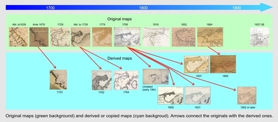
This abundance has a downside. Historical cartography may be misleading not only for the lack or inaccuracy of control points, the impreciseness of coastal outlines, the sheet deformations and the disappearance, change or shift of toponymies but also for reasons strictly inherent to the cartographic production of those times; for example, original surveys were sometimes printed with years of delay and had several reprints, possibly with the first printing date scraped off the copper plate and a more recent one added to improve their sale [9]. In many cases, they were only partially updated with new surveys without indicating which were the older parts. In addition, there are frequent cases of plagiarism, and the same map is proposed by other authors or by anonymous ones, eventually with place names translated and sounding values converted several years later (Figure 1 and Figure 2).
In most of the atlases published from the 16th to 18th century, a known editor does not correspond to an equally known author. This calls into question the gap (sometimes lasting centuries) separating the relief from the last edition of its printed maps. It is not rare to find atlases in which relatively updated maps coexist with older ones, often without a date on every single sheet. Normally, atlas editors referenced the new maps (in the legend or title) and overlooked the older ones, which eventually retained the original title but suggested updated maps (as in the examples of Novae or Novissime cartae …), so updates could have been driven by guile to make the product more attractive. Editors’ powers were so strong that the fame they acquired often overwhelmed that of authors and cartographers, as in the case of William Janzon Blaeu and Abraham Ortelius, who produced maps of sites that they never visited [10].
This produces chronologically misleading data, even in many of the records that accompany collections of digital maps on the web, which inevitably affect current studies that use historical cartography. Sometimes, as a result of comparing ancient maps with coeval written documents, these discrepancies are brought to light, but these records can also report unoriginal information or references to previous conditions.
An additional issue involves the entire nautical production: the lack of interest in inland territories. In other areas of the world, especially in Europe, this gap may be filled through a comparison with a massive production (from the 16th century onward) of medium and large-scale terrestrial cartography, which, in Colombia, except for some small-scale maps dedicated to the course of the most important rivers, is almost totally lacking until the 20th century.
2. Study Area
The Mestizos peninsula encloses Cispatá bay on the western side of the Morrosquillo Gulf (Colombian Caribbean coast; Figure 3). It is a Holocene depositional landform formed by Rio Sinú before its diversion occurred between 1937 and 1945, when the Tinajones delta started to grow [14].
Rio Sinú is one of the most important fluvial systems of the Colombian Caribbean, draining the Andes with a total length of about 415 km and a very intervened catchment area of 17,000 km2. Its mean discharge is about 398.09 m3/s (max. 858.2 m3/s, min. 29.1 m3/s) [15], and its sediment load is estimated to be in the order of 4.2 million t/y [16].
The area is affected by Intertropical Convergence (ITC) annual displacements between the latitudes 5° S and 15° N, which produces an arid xerophytic savanna climate, with annual mean temperatures of 28.3 °C (max. 28.8 °C in January and April; min. 27.9 °C in October and November). Mean annual rainfall is about 1230 mm, with 3.3 mm in January and 177.6 mm in September (data for Monteria from [17]). During the dry season (from December to April), north-east and north trade winds (Alisios) prevail with speeds between 4 and 23 kt, whereas the wet season (from August to November) is characterized by calms and slow winds mostly from the west and south-west.
The catchment area of Rio Sinú is on the Sinú and San Jacinto belts, two litho-stratigraphic units accreted to the Caribbean coast of Colombia as a result of the interactions occurring between the South American and Caribbean plates since Cretaceous times (Figure 4).
The current Sinú lower valley is located on the westernmost and youngest of these belts, the Sinú belt, a fragmented prism of about 7 km of sedimentary rock deposited in environments ranging from deep water turbidities to fluvio-marine and reefal conditions [18,19,20]. The relief that surrounds the present lagoon and swampy areas of the Sinú lower course and its Quaternary delta complex is, for the most part, composed of tectonically tertiary sedimentary rocks (sandstones, mudstones, coral reefs) crossed by systems of inverse and transcurrent active faults in the directions north-north east and north west, respectively.
The structure and morphology of the Sinú belt have also been deeply affected by mud diapiric intrusions that, near the Sinú delta, are evidenced by mud domes, mud fluxes and mud volcanoes found on the continental shelf and inland in the sectors of San Antero, Punta Mestizos, Punta de Piedra and Punta la Rada, among other places suffering strong subaerial and wave erosion [21,22,23].
3. Materials and Methods
To reconstruct the evolution of the study area from the late 16th to the early 20th century, approximately 500 manuscripts or printed maps (continental, subcontinental, regional and subregional scale gathered from the web), produced by six cartographic schools (Spanish, Dutch, English, French, German, Colombian), were examined and compared with tens of coeval written documents.
Maps produced from the 16th to the end of the 18th century were visually compared without georeferencing them because of their small scale and construction techniques. The originality of the relief and the reliability of these maps were assessed through synchronic and diachronic analysis.
The comparative approach did not highlight an increase in updates but a reiteration of old models until the beginning of the 21st century (Figure 2a), for example, in the first Atlas produced in Colombia by Vergara y Velasco between 1904 and 1909 [24,25]. Only a few original reliefs were identified: they have been copied or partially updated in the following centuries by known or anonymous authors.
Starting from the end of the 18th century, the original reliefs (or those considered as such in the literature) were subjected to georeferencing with QGIS Madeira 3.4.2 open-source software (Open Source Geospatial Foundation, Chicago, IL, USA). The limited number of ground control points, often ephemeral, and their shifts suggested a need to carry out retrospective georeferencing, starting from the most recently analyzed maps (1937) and working back to the oldest ones. To this end, descriptive sources were used to check not only coastal morphologies and water depths but also site distances, terminal river courses and mouths, with deltaic island Cispatà bay siltation and sea bottom evolution studied as well.
This procedure allowed a reconstruction of the geomorphological evolution of this area, the result of which was somewhat different from that proposed by Parsons [26], Robertson and Chaparro [27] and Serrano [14].
This can be explained by the methodological approach followed in the present work, namely, the synchronic and diachronic comparative analysis of hundreds of historical maps scattered in depositories on two continents, as well as the consultation of the descriptive sources considered herein. This procedure, presently made possible by the diffusion of high-res digital historical maps on the web, would not have been possible at the time that the above-mentioned authors performed their studies.
Similar situations make it likely that Cispatá is not the only area whose historical cartography-based evolution needs to be reviewed.
4. Geomorphological Evolution of the Area (Late 16th–Early 20th Century)
4.1. The 16th- and 17th-Century Maps
Rio Sinú’s mouth was drawn in 16th- and 17th-century small-scale maps that illustrate the seas and land of Caribe, sometimes enlarging the drawing to encompass the Pacific coast. Figure 5a shows the detail of Americae sive qvartae orbis partis nova et exactissima descriptio by Diego Gutiérrez (see [28]), which “includes more cities and more areas than previous maps” [29]. The 16th and 17th editions of Mercator and Ortelius atlases borrowed from this map, which, as with all small-scale 16th-century maps, can only give an approximate position of headlands, islands and river mouths. The map in Figure 5b is derived from Descriptionis Ptolemaicæ augmentum [30], the first printed atlas of the Americas, by Cornelius Wytfliet (1597). In both maps, the position of the Rio Sinú mouth is coherent with respect to that illustrated in original drawings of the following century by different authors.
These 17th-century maps provide evidence of both further replications of a model and updates, but no morphology reflects the one assumed for Cispatá bay in the new maps of the following century.
Figure 6 shows the Morrosquillo Gulf with Isla Fuerte and Isla San Bernardo. The Sinú mouth lies at the center of this gulf, with Cispatá bay not fully defined. Attention to navigation, one of the main uses of Renaissance coastal cartography, led to mapping the bottom type (mud, sand, rock) and the presence and extension of shoals. In Arent Roggeveen’s map (ante 1679, Figure 1a), a shoal stretches from the southern tip of the Morrosquillo Gulf. It is not the direction in which Mestizos later grew, but it is close to Baxo de Venados. Neither Cispatá bay nor the Mestizos spit are there. Instead, there are two Sinú mouths lying at the center of the Morrosquillo Gulf. The peculiar morphology of Islade San Bernardo is coherent with the current Islas or Archipelago de San Bernardo. Here, the depths show a passage for boats approaching (or leaving) the Morrosquillo Gulf, suggesting direct knowledge of this stretch of sea.
Antonio de Herrera y Tordesillas (Figure 6a) in Novus Orbis dedicates two lines to Rio Sinú (Zenu/Cenu), suggesting that Portus Zenu was 25 miles from Cartagena and that the bay was large enough to allow safe access from the east [22,32]. His text was republished and translated (often including original maps) from 1601 to 1990 [33]. The detail of Figure 6a is derived from one of the 14 maps forming the iconographic set of the Novus Orbis, republished in 1726 in the Historia general de los hechos de los castellanos, in which maps are presented as “clearly redrawn starting from the drafts of López de Velasco (ca. 1530–1598), or from a series of drafts of the same style” ([34], p. 166), authors’ translation from Spanish. Therefore, a map drawn in the 16th century was published in 1726 after an intermediate appearance in 1601.
In 1625, Joannes De Laet [36] wrote the Nieuwe Wereldt ofte Beschrijvinghe van West-Indien (…). This text is accompanied by maps (Figure 6b) and views in which the coastal profile reflects the long-lasting medieval tradition of portolan charts: scarce or null attention to the inland [9,38,39]. De Laet [40], in the Latin translation, published in 1633 under the title Novus orbis, seu, Descriptionis Indiae Occidentalis libri XVIII, briefly describes the waters of Morrosquillo and suggests that the safest landing place is in Isla Fuerte, but there is no mention of the existence of Mestizos.
Improvement in nautical cartography is evident in Figure 6c by Joan Vingboons (undated, 1639 attributed), in which Terra Vento (today Bajo Rada) and some shoals are represented and in which the Rio Sinú mouth is turned towards the northeast. Once again, no feature resembling the Mestizos headland or Cispatá bay is present. The interest in this map lies in the large sandbank that stretches from a position that reflects the one it has in Figure 1 and in a small island positioned where maps of the 18th century locate Mestizos.
4.2. The 18th-Century Maps
The contribution of terrestrial cartography became relevant in the 18th-century maps. Antonio Pérez Domingo’s map [41] (1729) (Figure 7a) shows the complexity of the low course of Rio Sinú, with a multitude of arroyos, caños and cañitos discharging into Cispatá bay. Since this the first detailed representation of this area, it is difficult to study the processes responsible for filling the bay and to evaluate the contribution made by the minor watercourses in past centuries. This gap is only partially filled by drawings of the second half of the 18th century, as in the example in Figure 7g, derived from an anonymous map of the early 18th century (likely by Don Juan de Herrera y Sotomayor, in this case, ante 1732, the year of his death) (Figure 7b). Figure 7a,b provides the first evidence of the Mestizos headland and Caño Salado, the river branch flowing on this landform.
Figure 7g shows another undated map. The author, Captain Jean Bertrand, was in command of a merchant vessel navigating the Netherlands and West Indies between 1717 and 1743. The descriptive card of a color printed copy [42] suggests a relief date between 1726 and 1755, but the map seems to illustrate Cispatá in the previous century since Mestizos is not present. Otherwise, the river would have extended its course by approximately 13 km in 3 years (from 1726 to 1729). This morphology is very likely an archaism that also accompanies a further reprint of the map in 1755.
All of the maps in Figure 7 show two (or more) Rio Sinú mouths: at Cispatá bay and at Punta Mestizos. Here, several distributaries separate some deltaic islands. All of these maps show fluvial islands similar to those formed by a meander cutting, and one of these (Isla de Yato) is close to the bottom of Cispatá bay: the east bank of the terminal river course is cut to form three islands (Sumina, Isla Larga and Gorgorro). Input to Cispata bay is also generated by river branches leaving the main course further upstream: in Figure 7a, Caño de San Juan Battista leaves Rio Sinù near La Doctrina and goes straight to Cispatá bay.
Herrera y Sotomayor’s map is the most likely source of many other documents, for example, Thomas Jeffereys’ 1762 map [43] (Figure 7c), which had a French version that was generated by Bellin in 1764 (Figure 7e) and was replicated in a second edition (with no mention of the previous) in 1774. In this case, they represent a morphology that is at least 30 and 40 years older, but they also suggest a habit of copying, and they highlight the risks that scholars may incur when dating morphologies on the basis of old maps.
Jeffereys’ map (1762, Figure 7c) is the first one entirely dedicated to Cispatá bay, and it is the starting point of most of the studies on the evolution of this area. This is despite the fact that in A description of the Spanish islands and settlements on the coast of the West Indies (...), the author himself specifies that his map of Cispatá bay comes “from surveys made by Don Juan de Herrera engineer of Cartagena.” The position, network and measurements of soundings in Figure 7b,c were compared: they overlap, and the same applies to toponyms, shoals and the coastal profile, as well as to the presence and position of Isla de Jato and Isla Larga. In a closer view, Jefferey’s map shows some updates and annotations, for example, “R. St. Juan communicates with Rio del Sino” (but the ramification is excluded from the map) and a drawing of another unnamed watercourse on its right (Figure 7c). This gives coherence to maps of the previous century showing two outlets flowing into the inner part of the bay.
Jefferey’s primary sources perhaps also comprise an original anonymous and undated map, possibly the one that is now preserved in Biblioteca Nacional de España with a descriptive card, which attributes the date to 1735 and relates it to Antonio de Ulloa (Figure 7g).
Figure 7 shows the complexity of the Rio Sinú delta, with mouths discharging in the inner bay (Rio San Juan spreading from Rio Sinú just downstream of San Nicolás di Bari) and with cañitos cutting the southern side of the headland to separate the three islands on the east bank and giving rise to a lobate delta (sensu [44]) with seven distributaries at Punta Mestizos, a morphology that was maintained for a long time (or copied by several authors).
Jefferey adds that several branches of the Rio del Sinú enter this bay, “in which a fleet of ships may ride at anchor in five or six fathoms of water (ca. 9 to 11 m), safe from most winds” ([43] p. 22). Therefore, at that time, the siltation of the bay was not so advanced.
An essential reference for the knowledge of Spanish America is given by the long-lasting hydrographic expedition, which started in the last years of the 18th century and was carried out under the command of Joaquín Francisco Fidalgo [50,51]. This exploration produced, together with reports, small- and large-scale nautical maps dedicated to harbors and bays. These maps show soundings and sea bottom typology. The Derrotero de las Islas Antillas, de las costas de Tierra Firme y de las del seno Mexicano ... 1810 [52] also focuses on the Rio Sinú mouth: it discharges in the inner part of Cispatá Bay and forms a west–south semicircle passing near Cispatá hills and the villages of San Bernardo del Viento (on the left bank) and San Nicolás and Santa Cruz de Lorica (on the right bank).
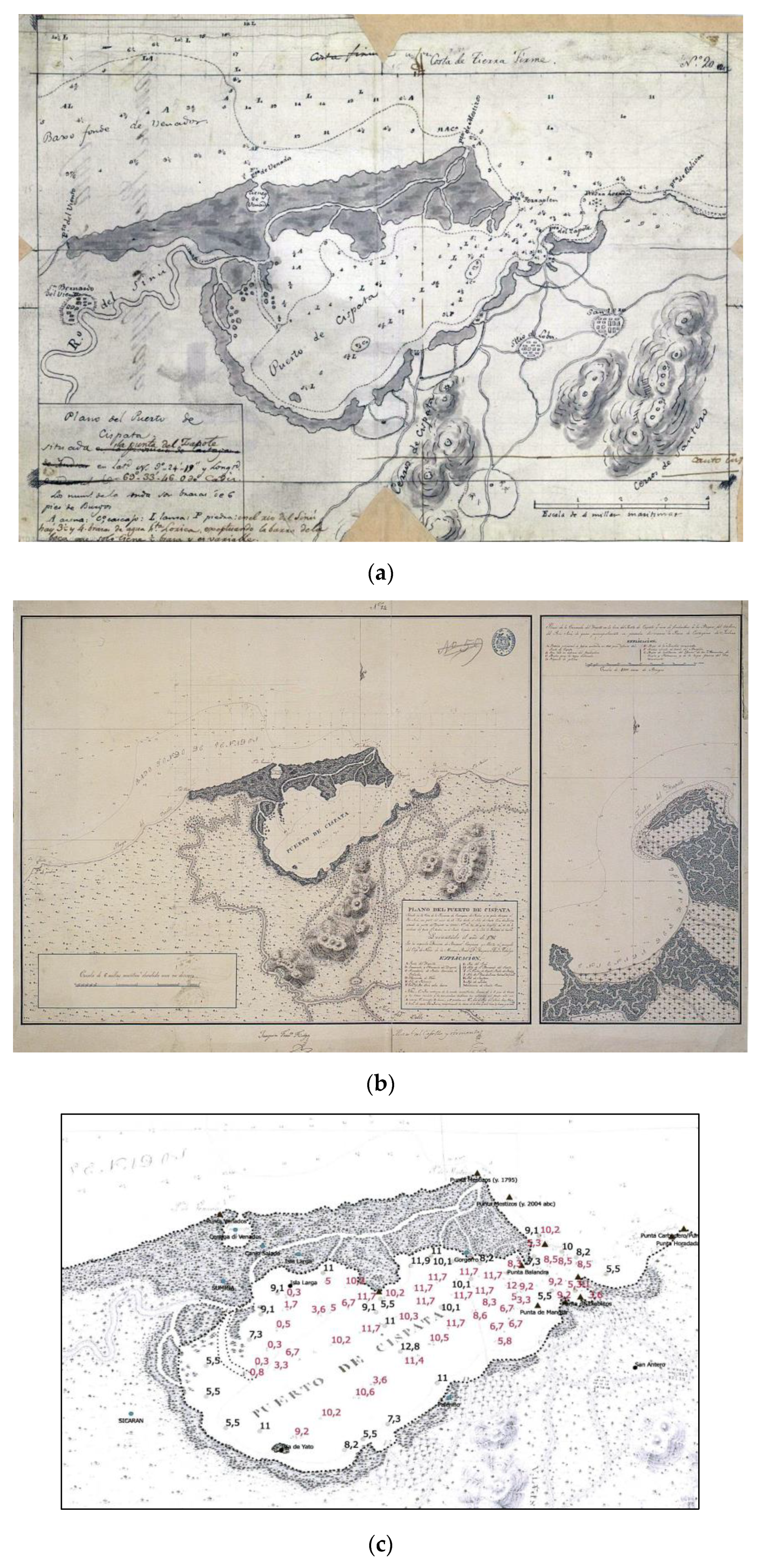
An undated manuscript map dedicated to Cispatá is left ([53] Figure 8a). It has corrections in the legend and could be the draft of a 1795 relief. It is the source of another undated, single and unbound printed map signed by Fidalgo with an inset devoted to Zapote bay (Figure 8b).
The second edition of the Derrotero (1820) ([54], especially pp. 356–358) extends the text of the first edition dedicated to Cispatá and is found illustrated in Fidalgo’s 1795 Plano del puerto de Cispatá: situado en la Costa de la Provincia de Cartagena de Yndias y en quien desagua el Rio ([55], Figure 8b).
Fidalgo describes two cañitos discharging along Mestizos at Punta Balandra and at Punta Terraplen: during the floods of Rio Sinú, the cañito de Mestizos emptied into the sea; this cañito originates close to River Sinú’s main mouth and, flowing for 5 miles through mangroves, ends at this headland. This indicates that at the end of the 18th century, Rio Sinú’s main mouth was in the inner part of the gulf (see Figure 8), and only during high-flow events, when the main mouth could not discharge all the water, was the river emptying at Punta Mestizos too.
Some of the 18th-century maps offer reliable data on the spatial extent and depth of the bay before 1732, and they were compared by Robertson [56], Robertson and Chaparro [27] and Serrano [14] with earlier or later maps. The same comparative approach was carried out for the present paper but using additional documents that guarantee more precise dating.
In Jeffereys’ (1762, but actually ante 1732) and Fidalgo’s (1795) maps, the shape of the bay and sounding positions are different (the former shows soundings next to the border of the bay that are neglected in the latter). Converting depth measurements to meters (Jeffereys gives them in English fathoms, in contrast to Herrera y Sotomayor and Fidalgo in brazas de pie de burgos; 1 fathom = 1.83 m; 1 braza = 1.67 m) and comparing them revealed evidence (Figure 8c) of fast and significant siltation of the inner bay in front of multiple Rio Sinú mouths from Sicaran to Punta Navíos. Here, Fidalgo drew, with the letter F, the entrance to the river mouth through a channel crossing a bar, where the water depth (in red) is approximately ½ braza (approximately 80 cm).
Even considering the aforementioned problems related to the georeferencing of old maps, it is evident that in front of the river mouth, over an approximately 15 km2 area, the water depth is reduced by several meters, whereas on the opposite side of the bay and at its entrance, no significant change occurs (Figure 8c).
4.3. The 19th-Century Maps
The richness in the number and models of 17th- and 18th-century nautical cartographic manuscripts disappears in the printed maps of the 19th century. Perhaps, with the partial exception of that by Codazzi [57] (Figure 9), the large-scale maps that are considered in the literature to show Cispatá bay are more or less exact copies of Fidalgo’s 1795 map (Figure 10c–e); most of the small-scale maps of the second half of this century derived the shape of the bay from maps of the early 19th century (Figure 10a,b). In all of them, Rio Sinú continues to discharge into the inner part of the bay.
In 1801, Alexander von Humboldt was sailing from Cuba to Cartagena, and because of stormy weather, he found refuge in Cispatá bay, where he spent one month. The Cispatá maps in Figure 10a,b [58], as written below the title, supposedly come from von Humboldt’s observations, but the Mestizos morphology reflects that of some earlier small-scale maps. His ship found shelter “near the Punta del Zapote, situated on the eastern bank of the Ensenada de Cispatá into which flows the river Sinú … so seldom visited by travellers and described by no modern voyager”. As in previous cases, no mention is made of a river mouth at Mestizos [59].
In the following decades, and until the beginning of the 20th century, new prints of Fidalgo’s map were published. In 1809, the Dirección de Trabajos Hidrográficos [60] published 114 nautical charts in the Portulano de la America Setentrional: dividido en quatro partes (Figure 10c). In 1818, a new version of Portulano was printed in Madrid; in 1825, another specimen was “Publicado por orden del Esemo sor d, Guadalupe Victoria, primero presidente de la Republica Mexicana”. All of these maps are similar, even those that are the result of new carvings and sometimes represent a smaller area.
In this set of maps, a perfect superimposition of morphologic features is present, and the same is observed for hydrography, street and settlement networks. A French copy of Fidalgo’s map (Còte de Terre Ferme. Port de Cispata), with no reference to the original, is dated 1831 (Figure 10d). Letters identifying seabed typology are coherent with the French legend, while rocks among Capo Bolívar and Punta Zapote (Piedra Horadada) bear the toponym Pierre perceé. The position of the original soundings is repeated from the original Spanish metrology, and the legend warns that brazas de Burgos are “longer than those of France by one pouce and ten lignes” (author’s translation from French).
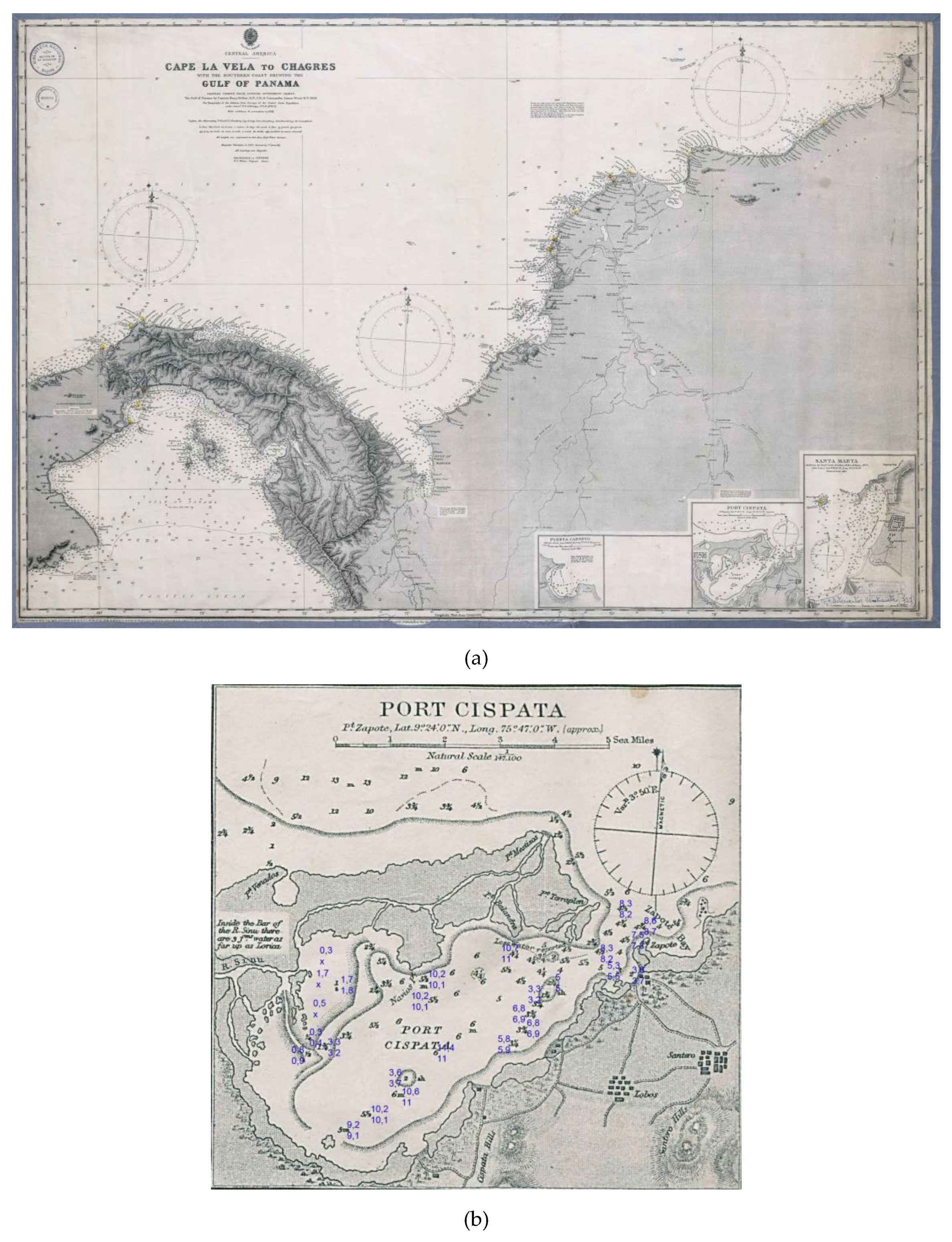
Furthermore, the West Indies: Sheet X from the Cabo la Vela to Cayos Ratones (Figure 10e), printed in 1837 by the Hydrographic Office of the British Admiralty (better known as the Kellet and Wood map), is admittedly derived “chiefly from (Spanish) documents”. Cispatá bay, once again a copy from Fidalgo, lies in one of the six insets of the map. Fidalgo soundings are converted into fathoms, the scale is changed, and an annotation about the Rio Sinú’s depths from the mouth to Lorida has moved from Fidalgo’s legend to the left lobe of Rio Sinú. The inset shows a different pictorial style for areas covered by mangroves. This new version of Fidalgo’s map continued to be reprinted until the beginning of the following century.
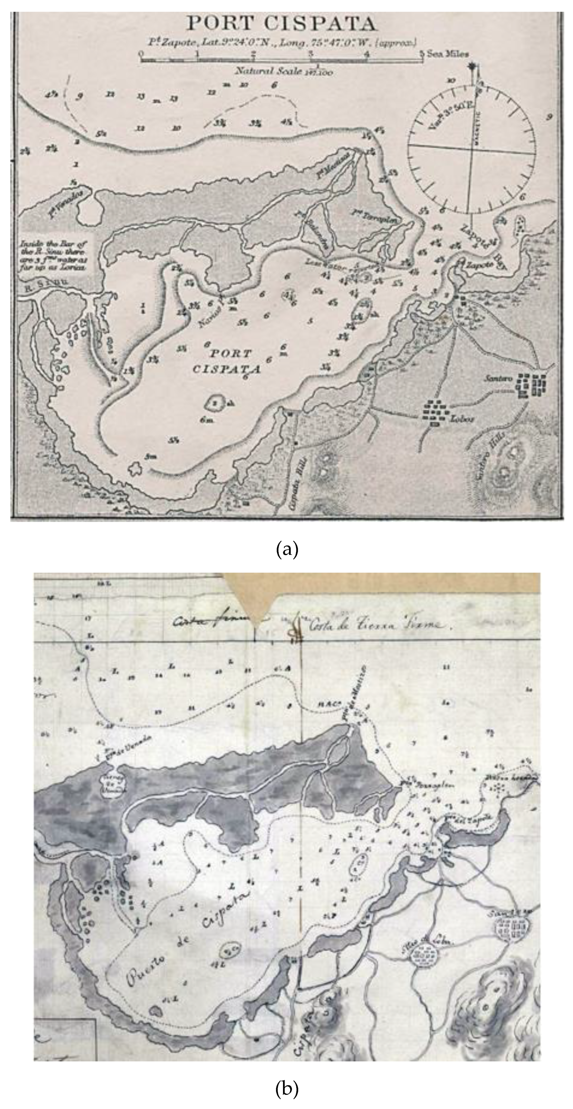
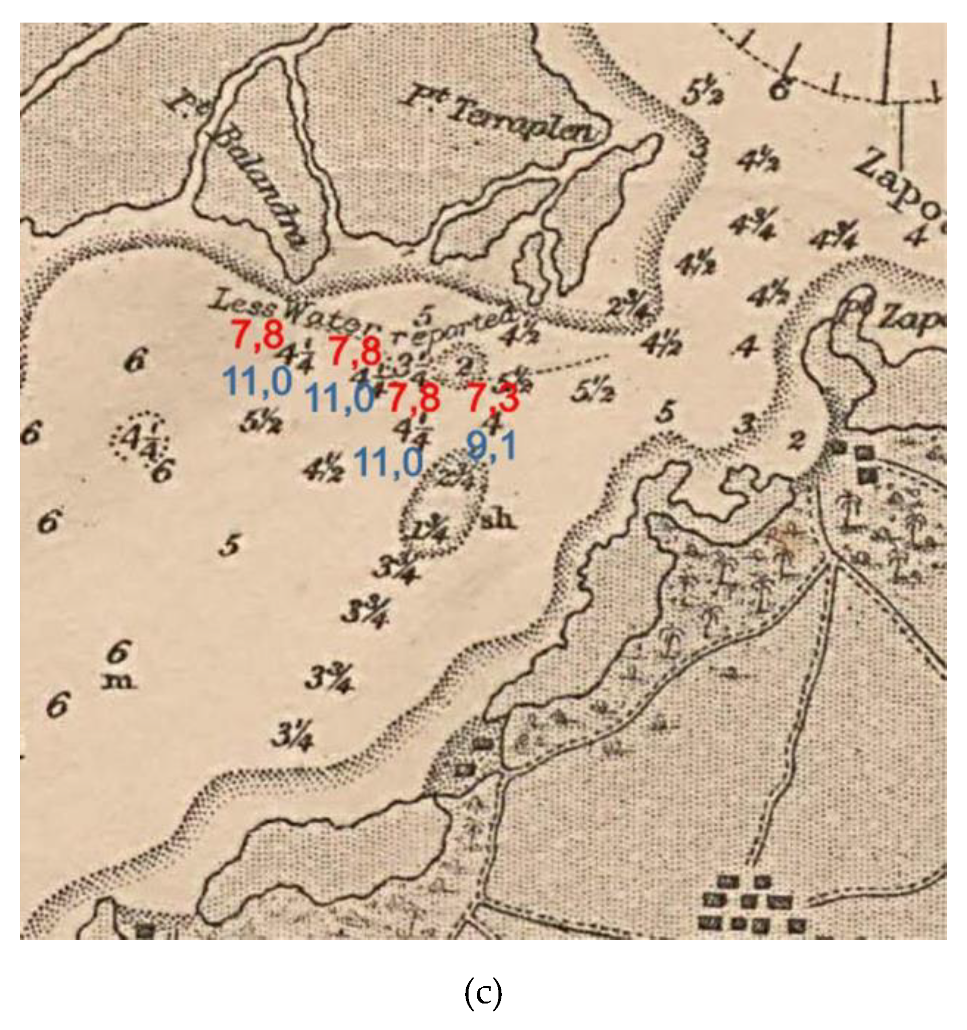
The Kellet and Wood map is another point of reference for studies on the evolution of this area. It was not possible to find the first edition mentioned in the volumes of the Admiralty Catalogue of Charts, which mentions different editions of this map (1860, 1869, 1880, 1888) and shows the only update for the last quarter of the century of five soundings in the area between Punta Terraplen and Punta Balandra (Figure 11b,c).
In contrast, it was possible to find Kellet and Wood’s The Central America. Cape la Vela to Chagres … The topography of the isthmus from surveys of the United States expedition under comm.r T. O. Selfridge, U. S. N. … 1870–1871. With additions & corrections to 1891 edited in 1892 by Davies & company.
This map was republished in 1902 (or later, as suggested by the addition to the legend of a 2′ annual decrease in magnetic declination in 1902 [13]), but unfortunately, the date of the map is probably masked by the reinforcement in the canvas along the margins (Figure 11a). This is, following the references given by Robertson and Chaparro (1988), the map that they used to study the situation of Cispatá in 1849 and the one that Serrano (2004) used to calculate the siltation of the bay in 1762–1849 and 1849–1938. The problem is that the Kellet and Wood 1849 soundings, other than the update of five points, are the same as those present in Fidalgo’s 1795 map. Once converted to meters (Fidalgo’s soundings are in brazas de Burgos and Kellet’s are in fathoms), they show very small differences (Figure 11b).
On the basis of 19th-century admiralty reports, Kellet’s authorship was excluded from the 1837 map (the same as that replicated in 1849 and until the beginning of the 21st century). In 1845, he actually navigated South America, but he was engaged in surveying in the Pacific. In this vessel he left England on June 26th 1845, and after exploring different parts in Chili and Perù, he commenced the survey of the coast of Colombia, between Guayaquil and Panama, till then only known from the accounts of Dampier and other older authors. This survey was completed with the aid of Commander James Wood [65].
The narrative of the voyage of H.M.S. Herald during the years 1845–1851, under the command of Captain Henry Kellett [66], suggests that Captain Kellet did not see the Atlantic coast of Colombia or Cispatá in particular: from England, he sailed to Tenerife, Capoverde, the Brazilian Fernando de Noronha Island. From Brazil, he set course to Capo Horn to explore the Pacific Coast of South and Central America. His long voyage gave birth to new maps of Colombia’s west coast too, but it is no accident that the 1902 (or later) map (Figure 11a) continues to warn that it is “compiled chiefly from Spanish government charts”; as for Cispata bay, the reference to Fidalgo’s map is now evident.
This is not a rare case. The so-called Codazzi map (1:1,350,000, Figure 9, Carta Jeográfica de los Estados Unidos de Colombia Antigua Nueva Granada, drawn following the trabajos corográficos del Jeneral A. Codazzi i a otros documentos oficiales por Manuel Ponce de León), directly reproduces the Cispatá profile in Carta corográfica del estado de Bolivar, construida con los datos de la comisión Corográfica y de orden del Gobierno general [67] by Ponce de León and Manuel María Paz. The small-scale map bears a note: Since the Corographic Commission did not travel in all the states of Bolivar, the present map has been formed mostly with old or reference document (authors’ translation from Spanish).
Coming back to Kellet and Wood’s map, the problem with the Cispatá inset is that the Spanish baseline map is more than one century older. Only the area of anchorage near Balandra was actually updated between 1849 and 1902 (Figure 11b,c). Scarce was the interest in the inner gulf, but it was useful to update an area of anchorage that had a water depth that was 3 or more meters lower than that recorded by Fidalgo. All of this means that there is no map able to provide a reliable view of Cispatá bay in the 19th century: it is a rare case in the panorama of historical cartography.
In the meantime, descriptive sources [68] state that Sinú River se perd dans l’interieur du port de Cispatá, again without mentioning a Mestizos mouth.
The map by Nepomuceno de Santamaría in 1852 (Figure 12), although too coarse to inform on coastal morphology, provides evidence of changes in the final river course. In addition to the Ferro de San Juan, very likely a meander cut, Caño de San Juan, possibly an artificial channel, diverts the river to the bay, possibly increasing the sedimentation in its inner part.
4.4. The Early 20th-Century Maps
The lack of reliable maps of Cispatá in the 19th century becomes problematic when considering, as explained by Francisco Javier Vergara y Velasco [70,71], that the Sinù River and Cispatá bay were and are subjected to continuous changes: “In this panorama, the Rio Sinú mouth presents an extraordinary aspect of desolation and confusion. Everywhere you find trunks, and weeds of all kinds growing on these nomadic islands.” The final stretch reveals a “sort of unstable archipelago and a labyrinth of narrow channels that suddenly clog, so that boats waste time looking for a passage, and sometimes they have to open it with axes. The river ends a little after the bay of Zapote, port of the safest but shallow.” These final words suggest that the situation of the bay, as well as Rio Sinu’s terminal course at the beginning of the 19th century, should not have been very different from that illustrated in Figure 13. The river was infilling Cispatá bay very quickly because “the deforestation of the upper part gets worse day by day, its waters drag more mud and are more violent, faster, and more frequent and floods increase. It fills with unprecedented speed, [...], it does not permit ships with drafts greater than 4 m, [...] the greater use of the river is to float the large quantities of wood extracted from the surrounding mountains” (authors’ translation from Spanish). Velasco ([70] pp. 307–308), referring to River Sinú, stated that “at a distance of 1.5 km from the sea, instead of finishing its course there, it goes for 15 km to the north east. Here Rio Sinú is separated from the Caribbean by a tongue of sand and runs in narrow meanders forming an area full of canios y ciénagas on its right side, which forms its delta which is a filled part of Cispatá Bay, where its course ends with many mouths” (authors’ translation from Spanish).
A “modern” and entirely updated new sea chart accompanies the surveys performed in 1937–1938 by Nokomis and Bushnell’s US ships (Figure 13). It has no information on the land, but it has a dense net of soundings and a detailed representation of Cispatá bay and of the hydrographic network developed in the filled-up area.
With respect to Rio Sinu, the apex of the meander of Venados is approximately 250 m from the coast, whereas, in 1795, it was 1500 m away. Both for the meander migration and for the coastal retreat (approximately 400 m from 1795 to 1937), the river course approaches the coast, favoring the opening of an access to the sea and the formation of the Tinajones delta.
However, the Caño Salado is no longer connected to Rio Sinù, which empties into Cispatà bay with many distributaries, the main one following the terminal course drawn by Fidalgo, but now extended for approximately 7 km so that sediment input to the tip of Mestizos is interrupted, and the infilling of the bay proceeds quickly.
Rio Sinú still discharges into Cispatá bay, and the infilling of the bay further progresses. Graham Cunningham [73], describing the Port of Cispatá in 1920, writes that it “is sheltered from most winds, but vessels have to lie much farther out (...) and round the port there is a mangrove swamp.”
5. Results
The analyzed documents cast doubt on the fact that, only in 1762, “the Sinú River turned east near the coast, followed the trend of the Mestizos spit, and formed a delta at the end” [14], as well as the hypothesis of a main mouth at Punta Mestizos from 1762 to 1849 and in Venados prior to 1762.
All of the documents considered in this study show the emptying of Rio Sinú into the inner part of Cispatá bay (or in the Morrosquillo Gulf in maps of the previous centuries). What the maps seem to suggest is that, in the 18th century, the cañito mouth at Punta Mestizos, as well as other secondary mouths along Mestizos, were receiving freshwater only in cases of flooding, when the main mouth in the bay was not able to discharge all the water arriving from the watershed, as stated by Fidalgo in the pages previously mentioned.
Mestizos very likely started to develop from the beginning of the 18th century, but what is not stressed in the literature is that after the formation of the delta at the tip of this headland, Rio Sinú continued to discharge into Cispatá bay through several mouths. This means backdating, by at least one century, the process described by Parson in 1952 for the beginning of the 19th century, when “a break-through on the right bank had diverted the main flow into Cispatá Bay” ([26], p. 70).
In the Gulf between Punta Zapote and Punta de Mangles, the Derrotero (1810) [52] describes a “small bay with sandy shore in all its length, with a water depth of 2–2 1/2 brazas over a muddy bottom”: nothing more than a landing site for small boats carrying wares and taking advantage of Rio Sinú’s navigability: The shallow water around Rio Sinú’s main mouth extends 1.25 miles because of the sands, brushwood and tree trunks the river drags, especially during floods (authors’ translation from Spanish). At the center of the bay, in which a depth of 6 brazas to a muddy bottom is marked, there are two small shoals with 2–2 ½ brazas of water over a gravel bottom. The best landing place is in the north sector, between Punta Balandra and Punta Navios. However, boats never linger here for a long time and choose anchorage near the entrance of the bay.
This description indirectly confirms the little importance, or the absolute absence, of a Mestizos mouth, thus contrasting with the first three stages of the evolution of Cispatá bay connected to the morphology and position of the Rio Sinú mouth, on which the currently accepted four deltaic phases of the Rio Sinú [27] are based: “Los Venados (before 1762), Mestizos (1762–1849), Cispatá (1849–1938) and Tinajones (after 1938, to present). On average, the delta has remained more or less stable for 100 years in each stage” ([27], see also [14] and [74]), authors’ translation from Spanish). None of the hundreds of maps considered in this study provide evidence of a Sinú mouth in Venados before the 20th century, and well before 1849, they show active mouths in the inner part of the gulf.
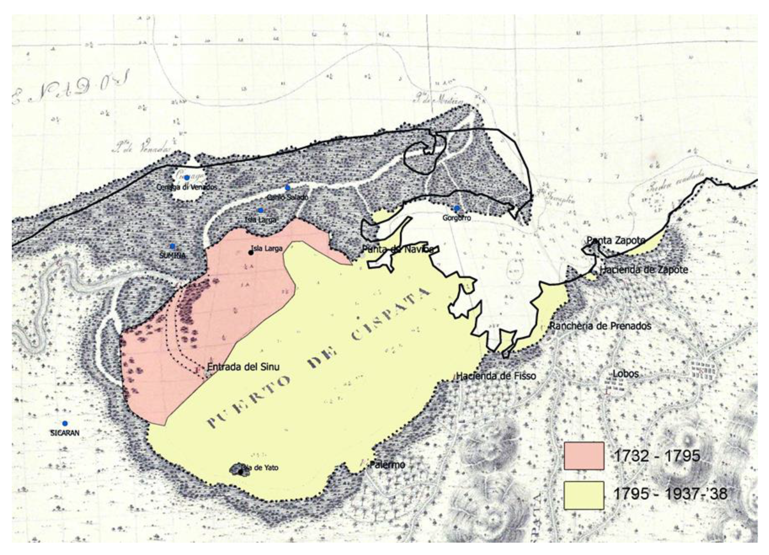
The intense 18th–19th-century siltation of Cispatà bay has evidently overlapping among the different “original” maps: de Herrera y Sotomayor (ante 1732), Fidalgo (1795) and Nokomis and Bushnell (1937–1938) (Figure 14).
In the first period, siltation was mostly on the northwestern side of the bay, very likely because of the main mouth of the Rio Sinù represented on Fidalgo’s map. In 63 years, the water surfaces reduced from approximately 90 km2 to 75 km2, although the new 15 km2 land was not completely dry.
In the following 143 years, the bay was almost entirely filled up, with a further land accretion of 61 km2. The Puerto de Cispatà now has a surface of only 14 km2. Where the water depth was up to 13 m in 1795, rice is now cultivated; in other places, sand shoals, separated by caños, lagunas and ciénagas, (channels and swamps) emerged. Punta de Navíos, Punta Balandra, Punta Terraplen and the tip of Mestizos experienced erosion during a process of coastal reshaping.
6. Conclusions
Historical cartography and descriptive sources suggest that in the 16th and 17th centuries, Rio Sinú’s mouth was some kilometers further back, infilling a gulf, and was progressively reduced to the Cispatá bay, which appears to be more clearly mapped in the 18th-century documents. For the first two centuries, the shortage of descriptive sources ultimately could have obscured this first phase of Cispatà bay formation as a consequence of the growth of Mestizos, considered by Elisee Reclus [75] to be “a prolonged alluvial ridge towards the east, due to a coastal countercurrent, that causes the river to be diverted laterally directing it to the Gulf of Morrosquillo” (authors’ translation from Spanish).
The origin of the shoals at Venados, whose existence has been indicated without a connection to a river mouth since the 16th century, remains a problem to be solved with specific studies, possibly with cores and geophysics. Seismic profiles east of that area show limited sedimentary deposits over a rock platform [76].
Diapirism phenomena, as described by Correa et al. [22], may have contributed to the formation of Venados deposits by uplifting some coastal sector. A second phase (ca. end of 17th century or beginning of 18th century to 1940) is marked by Mestizos’ partial closure of the old gulf, which once was completely opened to the sea and where Rio Sinú maintains its mouth. The growth of Mestizos (ca. end of 17th century or beginning of 18th century to 1732), where perhaps an ephemeral mouth could have existed at the beginning of the 18th century, supported the infilling of Cispatá bay.
This reconstruction contrasts with the first three stages out of the four that describe the evolution of Cispatá bay (as well as their timing) as being connected with the morphology and position of Rio Sinú’s mouth, as is generally accepted in the literature: Los Venados (before 1762), Mestizos (1762–1849), Cispatá (1849–1938) and Tinajones (from 1938 until today; this suggests the stability of the delta during each 100-year-long stage [14,27,74]). Only one map (Figure 7a, 1729) of the hundreds consulted for this study actually clearly shows a Rio Sinú main mouth at Punta Mestizos and one narrower branch discharging into Cispatá bay. In maps from the following years, many other mouths forming deltaic islands appear. If it ever existed, the Mestizos mouth lost its prominence in the first decades of the 18th century, and all descriptive sources here examined describe Rio Sinú as discharging inside the bay. No evidence was found suggesting that “between 1762 and 1849, the Sinú River deviated its entire course through one of the crevasse channels and abandoned its delta at Mestizos spit, which was then affected by marine water intrusion” as written by Serrano [14]. This mouth was active well before 1762. Moreover, once it is accepted that Kellet and Wood’s 1849 map is derived from Fidalgo’s 1795 map, there are no data to calculate the reduction of the Cispatá bay surface between 1762 and 1849 or the sedimentation rate from 1849 to 1937 ([14], p. 626, 627, 629, 630).
Cispatá bay, from at least the 19th century until 1937–1938, was also supplied by Rio Sinú’s main mouth (today recognizable in the first section of Caño Grande still emptying into the bay). Nokomis and Bushnell’s map shows other caños stretching across part of the bay, which was more recently infilled (Rio Remedios de los Pobres, today Caño Remedios Pobres). One of the most important discharges of Sinú’s mouth into Cispatá bay in front of Ysla de Yato (Rio San Juan, probably artificially excavated) no longer exists, but many other caños were connected to the southern side of the bay. Human interference in the lower Rio Sinú course could be conjectured on the basis of a map drawn in 1852 (Figure 12), performed via meander cuttings and the excavation of a canal leading to Cispatá bay. However, human impact was also occurring in the Rio Sinù watershed since at least the 19th century with the deforestation described by [70].
Other branches of Rio Sinú discharged in Cispatá bay, but the mouth and courses changed position, disappeared rapidly or lost their connection with the main course. The situation is still described in Nokomis and Bushnell’s map (1937–1938), in which Caño Salado shows no connection with Rio Sinú.
Thus, when and under which processes Mestizos formed is still an open question.
Author Contributions
Conceptualization and archive research, M.P.; writing and editing, M.P. and E.P.; geological framework, I.D.C. All authors have read and agreed to the published version of the manuscript.
Funding
This research received no external funding.
Conflicts of Interest
The authors declare no conflict of interest.
References
- Campbell, T. Web Articles and Commentaries on Specific Topics in the History of Cartography. Available online: https://www.maphistory.info/webtexts.html (accessed on 28 December 2019).
- Rombai, L. Le problematiche relative all’uso della cartografia storica. In Bollettino Dell’associazione Italiana di Cartografia; EUT Edizioni Università Di Trieste: Trieste, Italy, 2010; Volume 138, pp. 69–89. [Google Scholar]
- Provansal, M.; Pichard, G.; Anthony, E.J. Geomorphic Changes in the Rhône Delta during the LIA: Input from the Analysis of Ancient Maps. In Sediment Fluxes in Coastal Areas; Maanan, M., Ed.; Springer: Berlin, Germany, 2016; pp. 47–72. [Google Scholar]
- Piccardi, M. Small, medium and large-scale maps in coastal studies. What happened to Arno’s mouth between the XIVth and the XIXth century. In E-Perimetron; Hellenic National Centre for Maps and Cartographic Heritage: Thessaloniki, Greece, 2014; Volume 9, pp. 176–195. Available online: http://www.e-perimetron.org/Vol9_4.htm (accessed on 28 December 2019).
- Piccardi, M.; Pranzini, E. Carte a Piccola, Grande e Grandissima Scala Negli Studi Sull’evoluzione del Litorale. Cosa è Successo a Bocca d’Arno tra il XVI e il XIX Secolo? In L’universo; Istituto Geografico Militare: Firenze, Italy, 2014; Volume 5, pp. 7–38. Available online: https://www.researchgate.net/publication/324645904_Carte_a_piccola_grande_e_grandissima_scala_negli_studi_sull’evoluzione_del_litorale_Cosa_e_successo_a_Bocca_d’Arno_tra_il_XVI_e_il_XIX_secolo_In_L’UNIVERSO_Anno_XCIV_2014_n_5 (accessed on 28 December 2019).
- Piccardi, M.; Pranzini, E. Le foci del Serchio e del Fiume Morto Nelle Restituzioni Cartografiche Pre-Geodetiche. In Studi Costieri; 2014; Volume 23, pp. 21–58. Available online: https://www.researchgate.net/publication/323581889_Le_foci_del_Serchio_e_del_Fiume_Morto_nelle_restituzioni_cartografiche_pre-geodetiche (accessed on 28 December 2019).
- Mestanza, C.; Piccardi, M.; Pranzini, E. Coastal Erosion Management at Callao (Peru) in the 17th and 18th Centuries: The First Groin Field in South America? Water 2018, 10, 891. Available online: https://www.researchgate.net/publication/326195246_Coastal_Erosion_Management_at_Callao_Peru_in_the_17th_and_18th_Centuries_The_First_Groin_Field_in_South_America (accessed on 28 December 2019). [CrossRef] [Green Version]
- Dunsterville, E. Admiralty Catalogue of Charts, Plans, Views, and Sailing Directions; George Edward Eire-William Spottiswode: London, UK, 1864; p. 197. Available online: https://archive.org/details/admiraltycatalo00rngoog/page/n10 (accessed on 28 December 2019).
- Lepore, F.; Piccardi, M.; Pranzini, E. Latitudine senza latitudine. Determinazioni astronomiche e carte per navigare dell’Europa tardo edieval: Le innovazioni di Francesco Beccari. Studi Costieri 2017, 27, 33–107. Available online: https://www.researchgate.net/publication/323581862_Latitudine_senza_latitudine_Determinazioni_astronomiche_e_carte_per_navigare_dell’Europa_tardo-medievale_le_innovazioni_di_Francesco_Beccari, (accessed on 28 December 2019).
- Schilder, G.; van Egmond, M. Cartography in the Low Countries during the Renaissance. In The History of Cartography; University of Chicago Press: Chicago, IL, USA, 2007; Volume 3, pp. 1383–1432. [Google Scholar]
- Arent, R. De Cust van Westindien Tußchen I. Cares en C. de Tÿburon. 1679. Available online: https://gallica.bnf.fr/ark:/12148/btv1b53121812s.r=btv1b53121812s?rk=21459;2 (accessed on 28 December 2019).
- Anonymous. Pas-kaarte Van de Zee Kusten van Carthagena Tierra Firma […]. In Le nouveau et Grand Illuminant Flambeau de la Mer. l.a Quatrieme Partie; Biblioteca Nacional De España: Amsterdam, The Netherlands, 1723; Available online: http://bdh.bne.es/bnesearch/detalle/bdh0000141049 (accessed on 28 December 2019).
- Kellett, H.; Wood, J. The Central America. Cape la Vela to Chagres with the Southern Coast Shewing the Gulf of Panama. Compiled Chiefly from Spanish Government Charts. The Gulf of Panama by Captain Henry Kellett, R.N., C.B. Commander James Wood, R.N. 1849. The Topography of the Isthmus from Surveys of the United States Expedition under Comm.r T.O.; Selfridge, U.S.N. 1870–1871. With Additions & Corrections to 1891; Archivo General de la Nacion, Bogota, Mapoteca 4, Mapa 727, Date Unreadable, 1902 or Later. Available online: https://repository.urosario.edu.co/bitstream/handle/10336/4087/mapotecacolombiana.pdf?sequence=1 (accessed on 28 December 2019).
- Serrano Suarez, B.E. The Sinù river delta on the Northwestern Caribbean coast of Colombia: Bay infilling associated with delta development. J. S. Am. Earth Sci. 2004, 16, 623–631. [Google Scholar] [CrossRef]
- Restrepo, J.C.; Ortiz, J.C.; Pierini, J.; Schrottke, K.; Maza, M.; Otero, L.; Aguirre, J. Freshwater discharge into the Caribbean Sea from the rivers of Northwestern South America (Colombia): Magnitude, variability and recent changes. J. Hydrol. 2014, 509, 266–281. [Google Scholar] [CrossRef]
- Restrepo, J.D.; López, S.A.; Restrepo, J.C. The Effects of Geomorphic controls on sediment yield in the Andes rivers of Colombia. Latin American. J. Sedimentol. Basin Anal. 2009, 16, 79–92. [Google Scholar]
- IDEAM. Instituto de Hidrología, Meteorología y Estudios Ambientales; Universidad Nacional de Colombia Morfodinámica, Población y Amenazas Naturales en el Litoral Caribe Colombiano: Valle del Sinú-Morrosquillo-canal del Dique; Santa Fe de Bogotá: Bogotà, Colombia, 1998.
- Vernette, G.; Mauffret, A.; Bobier, C.; Briceño, L.; Gayet, J. Mud diapirism, fan sedimentation and strike-slip faulting, Caribbean Colombian Margin. Tectonophysics 1990, 202, 335–349. [Google Scholar] [CrossRef]
- INGEOMINAS. Mapa Geològico de Colombia; Escala 1:1,000,000; Colombian Geological Survey: Bogotà, Colombia, 2007.
- INGEOMINAS. Geología de las planchas 43 San Antero—43 bis San Bernardo del Viento, Escala 1: 100,000. In Memoria Explicative; Colombian Geological Survey: Bogotà, Colombia, 2003. [Google Scholar]
- Correa, I.D.; Morton, R. The Caribbean Coast of Colombia. 2003. Available online: https://coastal.er.usgs.gov/coasts-colombia/ (accessed on 15 April 2018).
- Correa, I.D. Erosión litoral entre Arboletes y Punta San Bernardo, Costa Caribe colombiana. Boletín Geol. 2007, 29, 2. [Google Scholar]
- Carvajal, H. Mud Diapirism in the Central Colombian Caribbean Zone. In Landscapes and Landforms of Colombia. World Geomorphological Landscapes; Hermelin, M., Ed.; Springer: Berlin/Heidelberg, Germany, 2016; pp. 35–53. [Google Scholar]
- Vergara, Y.; Velasco, F.J. Atlas Completo de Geografía Colombiana; Imprenta Eléctrica, Biblioteca Nacional de Colombia: Bogotá, Colombia, 1906–1910.
- Blanco Barros, J.A. El general Francisco Javier Vergara y Velasco y Sus Obras; Academia Colombiana de Historia: Bogotá, Colombia, 2006; Available online: https/www.sogeocol.edu.co/documentos/fjvvelasco.pdf (accessed on 28 December 2019).
- Parsons, J.J. The Settlement of the Sinù Valley of Colombia. Geogr. Rev. 1952, 42, 67–86. [Google Scholar] [CrossRef]
- Robertson, K.; Chaparro, J. Evolucion historica del delta del rıo Sinù. In Cuadernos de Geografia: Revista Colombiana de Geografía; Universidad Nacional de Colombia: Bogotà, Colombia, 1998; Volume 7, pp. 70–86. Available online: https://revistas.unal.edu.co/index.php/rcg/article/view/70834 (accessed on 28 December 2019).
- Hébert, J.R. The 1562 Map of America by Diego Gutiérrez s.d. Available online: https://www.loc.gov/rr/hispanic/frontiers/gutierrz.html (accessed on 28 December 2019).
- Martínez García, P. Mapping the ‘New World’: Medieval Traditions of Othering. Cartografiando el “Nuevo Mundo”: Tradiciones Medievales de Otredad. In Vegueta Anuario de la Facultad de Geografía e Historia; 2018; Volume 18, pp. 119–131. Available online: https://accedacris.ulpgc.es/bitstream/10553/25201/1/0234500_00018_0006.pdf (accessed on 28 December 2019).
- Wytfliet, Cornelius, Castilia aurifera. In Descriptionis Ptolemaicæ Augmentum; The John Carter Brown Library: Louvain, Belgium, 1597; Available online: https://jcb.lunaimaging.com/luna/servlet/detail/JCBMAPS~1~1~3398~101640:%20Castilia-aurifera-cum-vicinis-provi (accessed on 28 December 2019).
- Gutiérrez’, D. Americae Sive Quartae Orbis Partis Nova Et exactissima Description; Library of Congress: Washington, DC, USA, 1562. Available online: https://www.loc.gov/resource/g3290.ct000342 (accessed on 28 December 2019).
- Herrera y Tordesillas, Antonio de. In Novus Orbis, Sive, Descriptio Indiae Occidentalis; Michaelem Colinium: Amsterdam, The Netherlands, 1622; Available online: https://archive.org/details/novusorbissivede00herr/page/n4 (accessed on 28 December 2019).
- Cuesta, D.M. Estudio Critico Antonio de Herrera y Tordesillas; Edición Digital: Fundación Ignacio Larramendi: Madrid, Spain, 2015; p. 57. Available online: http://www.larramendi.es/es/catalogo_imagenes/grupo.do?path=1023152 (accessed on 28 December 2019).
- Berthe, J.P. Juan Lopez De Velasco (Co. 1530–1598). Cronista Y Cosmógrafo Mayor Del Consejo De Indias: Su Personalidad Y Su Obra Geográfica. In Relaciones 75, Verano, Vol. XIX.; Escuela de altos Estudios en Ciencias Sociales: París, France, 1998; pp. 142–172. Available online: https://www.colmich.edu.mx/relaciones25/files/revistas/075/JeanPierreBerthesecTem.pdf (accessed on 28 December 2019).
- Herrera y Tordesillas, Antonio de. Descripcion del Audiencia del Nuevo Reino, Barry Lawrence Ruderman Antique Maps. 1601. Available online: https://www.raremaps.com/gallery/detail/0362gh/descripcion-del-audiencia-del-nuevo-reino-columbia-venezu-herrera-y-tordesillas (accessed on 28 December 2019).
- De Laet, J. De Groote Ende Kleyne Eylanden van West-Indien. In Nieuvve Wereldt, Ofte, Beschrijvinghe van West-Indien: Wt Veelderhande Schriften Ende Aen-Teeckeninghen van Verscheyden Natien. 1625. Available online: https://archive.org/details/nieuvvewereldtof00laetrich/page/n3 (accessed on 28 December 2019).
- Vingboons, J. De Eylanden en Vastelanden van Westindien, Library of Congress. 1639. Available online: http://hdl.loc.gov/loc.gmd/g3300.lh000029 (accessed on 28 December 2019).
- Campbell, T. A Critical Re-Examination of Portolan Charts with a Reassessment of Their Replication and Seaboard Function, 2011–2019. Available online: http://www.maphistory.info/portolan.html (accessed on 28 December 2019).
- Lepore, F.; Piccardi, M.; Pranzini, E. Costa e Arcipelago Toscano nel Kitab I Bahriye un Onfront Cartografico (Secoli XIII-XVII); Ghezzano: Pisa, Italy, 2011; p. 174. Available online: https://www.researchgate.net/profile/Marco_Piccardi2 (accessed on 28 December 2019).
- De Laet, J. Novvus Orbis Seu Descriptionis Indiae Occidentalis Libri XVII: Novis Tabulis Geographicis et Variis Animantium, Plantarum Fructumque Iconibus Illustrati, Elzeviros, Leida. 1633. Available online: https://archive.org/details/novusorbisseudes00laet/page/n6 (accessed on 28 December 2019).
- Pérez, D.A. Plano y Descripción de la Costa y Provincia de Cartagena de Yndias Desde Sta. Marta Hasta el Río del Senut y Ysla Tortuga Puestos Todos Sus Paraxes en Sus Verdaderas Latds. Y Longds. Segun el Eridian del Cuerbo; Library of Congress: Washington, DC, USA, 1729. Available online: https://www.loc.gov/resource/g5292c.lh000284/?r=0.48,0.041,0.257,0.097,0, (accessed on 28 December 2019).
- Het Geheugen (The Memory). Available online: https://geheugen.delpher.nl/en/geheugen/view?coll=ngvn&identifier=NESA01%3AK04-0210 (accessed on 28 December 2019).
- Jefferys, T. Gulf of Morrosquillo. Plan of Zisapata bay. In A Description of the Spanish Islands and Settlements on the Coast of the West Indies: Compiled from Authentic Memoirs, Revised by Gentlemen Who Have Resided Many Years in the Spanish Settlements: And Illustrated with Thirty-Two Maps and Plans, Chiefly from Original Drawings Taken from the Spaniards in the Last War; Faden and Jefferys, The Corner of Saint Martin: London, UK, 1762; Available online: https://archive.org/details/descriptionofspa00jeff/page/n8 (accessed on 28 December 2019).
- Galloway, W.E. Process framework for discriminating the morphologic and stratigraphic evolution of deltaic depositional systems. In Deltas. Models for Explorations; Broussad, M.L., Ed.; Huston Geological Society: Huston, TX, USA, 1975; pp. 87–96. [Google Scholar]
- Anonymous. Biblioteca Nacional De España. 1732. Available online: http://bdh-rd.bne.es/viewer.vm?id=0000143609 (accessed on 28 December 2019).
- Bellin, J.N. Plan de la Baye de Zisapata a la Coste de Terre Ferme, 1st ed.; Pranzini’s Private Collection: Córdoba, Colombia, 1764. [Google Scholar]
- De la Torre y Miranda Antonio. Plan Que Manifiesta las Costas de la Mar del Norte y Sur, y Terrens Que Intermedia Entre Los Rios Sinù, y Atrato Con Sus Canos, Quebradas, Ríos Que Desaguan en Ellos, y el Camino Que de Orden de Exmo. Sr. D. Manuel Antonio de Flores, Comendador de Lopera. 1779. Available online: https://www.raremaps.com/gallery/detail/34467hs/plan-que-manifiesta-las-costas-de-la-mar-del-norte-y-sur-y-de-la-torre-y-miranda (accessed on 28 December 2019).
- Anonymous. Carta de las Costas de Nueva Granada Comprendidas Entre la Punta de Las Marcas y Santa Marta; Biblioteca Nacional De España: Madrid, Spain, 1735; Available online: http://bdh-rd.bne.es/viewer.vm?id=0000143586= (accessed on 28 December 2019).
- Bertrand, J.; Van, K. Nieuwe en Zeer Naaukeurige Paskaart van de Kusten van West Indien Strekkende van rio Oronoque tot Beneede Cartagena Met alle de Caribische Eylande. 1726. Available online: https://gallica.bnf.fr/ark:/12148/btv1b53103244q.r=btv1b53103244q?rk=21459;2 (accessed on 28 December 2019).
- Cuervo, A.B. Colección De Documentos Inéditos Sobre La Geografìa y La Historia De Colombia [...]; Expedición Fidalgo, Imprenta de Vapor de Zalamea Hermanos: Bogotà, Colombia, 1891; Volume I, Available online: https://repository.javeriana.edu.co/handle/10554/83 (accessed on 28 December 2019).
- Martín-Merás, L. La Expedición Hidrográfica del Atlas de la América septentrional, 1792–1805. J. Lat. Am. Geogr. 2008, 7, 203–218. [Google Scholar] [CrossRef]
- Derrotero de las Islas Antillas, de las Costas de Tierra Firme y de las del Seno Mexicano […]; La Imprenta Real: Madrid, Spain, 1810; Available online: https://archive.org/details/derroterodelasi00spaigoog/page/n9 (accessed on 28 December 2019).
- Fidalgo Joaquín Franco. Costa de Tierra Firme, Plano del Puerto de Cispata; Biblioteca Virtual del Patrimonio Bibliográfico, Museo Naval, Colección: Madrid, Spain, 1795; Available online: https://bvpb.mcu.es/es/consulta/resultados_ocr.do?id=9192&forma=ficha&tipoResultados=BIB&posicion=2 (accessed on 28 December 2019).
- Derrotero de las Islas Antillas, de las Costas de Tierra Firme y de Las del Seno Mexicano […]; La Imprenta Nacional: Madrid, Spain, 1820; Available online: https://catalog.hathitrust.org/Record/011640551 (accessed on 20 December 2019).
- Fidalgo Joaquín Franco. Plano del seno de Cispata […] Levantado el año de 1795 por La segunda División de Bergants. Empresa y Alerta el mando del Capn. De Navío de la Marina Real Dn. Joaquín Franco. Fidalgo, Manuel del Castillo y Armenta. Insect dedicated to the nsenada de Zapote, Biblioteca Virtual del Patrimonio Bibliográfico. 1795. Available online: https://bvpb.mcu.es/es/consulta/resultados_ocr.do?id=9192&forma=ficha&tipoResultados=BIB&posicion=3 (accessed on 28 December 2019).
- Robertson, K. Avulsión, cambios de curso y delta del Río Sinù. In Revista CIAF, II Simposio Latinoamericano de Sensores Remotos; Ministerio de Obras Publicas y Transporte, Centro Interamericano de Fotointerpretacion: Bogotà, Colombia, 1987; pp. 237–249. [Google Scholar]
- Codazzi, B.A. Carta Jeográfica de los Estados Unidos de Colombia Antigua Nueva Granada; Biblioteca Nacional De España: Madrid, Spain, 1865; Available online: http://bdh.bne.es/bnesearch/detalle/2671251 (accessed on 28 December 2019).
- Heinrich Michaelis Ernst; von Humboldt Alexander; de Caldas Francisco José, Carte du Rio Grande de la Magdalena depuis le 4 de Latitude Jusqu’à son Embouchure Dressée d’après les Observations Astronomiques & des Mesures Barometriques par Alexandre de Humboldt, Gallica. 1816. Available online: https://gallica.bnf.fr/ark:/12148/btv1b8492825r.r=btv1b8492825r?rk=21459;2 (accessed on 28 December 2019).
- Humboldt, A.V.; Bonpland, A. Personal Narrative of Travels to the Equinoctial Regions of America during the Years 1799–1804; George Bell & Sons: London, UK, 1908; Volume 3, Available online: https://archive.org/details/personalnarrati00humbgoog/page/n5 (accessed on 28 December 2019).
- Dirección, d.T.H. Portulano de la America Setentrional: Dividido en Quatro Partes Construido en la Direccion de Trabajos Hidrograficos Edición; Biblioteca Virtual del Patrimonio Bibliográfico: Madrid, Spain, 1809; Available online: https://bvpb.mcu.es/es/consulta/registro.cmd?id=448106 (accessed on 28 December 2019).
- Nieto, M.; Muñoz, S.; Díaz-Piedrahita, S.; Arias, J. La obra Cartográfica de Francisco José de Caldas; Ediciones Uniandes, Academia Colombiana de Historia, Academia Colombiana de Ciencias Exactas Físicas y Naturales, Instituto Colombiano de Antropología e Historia ICANH: Bogotá, Colombia, 2006; Available online: https://www.researchgate.net/publication/262439511_Mauricio_Nieto_Olarte_La_obra_cartografica_de_Francisco_Jose_de_Caldas_Mauricio_Nieto_Olarte_Santiago_Munoz_Arbelaez_Santiago_Diaz-Piedrahita_Jorge_Arias_de_Greiff_Bogota_Universidad_de_los_Andes_Facu (accessed on 28 December 2019).
- Anonymous. Plano del Puerto de Cispata: Situada la Punta del Zapote en Longitud N 9 24′ 19” y Longitude 69 33′ 46” O. de Cadiz; Biblioteca Virtual del Patrimonio Bibliográfico, Cartoteca del Archivo General Militar de Madrid, Colección: Madrid, Spain, 1809; Available online: https://bvpb.mcu.es/es/consulta/resultados_ocr.do?id=9192&forma=ficha&tipoResultados=BIB&posicion=1 (accessed on 28 December 2019).
- Anonymous. Port de Cispata […], Gallica. 1831. Available online: https://gallica.bnf.fr/ark:/12148/btv1b531220481.r=btv1b531220481?rk=21459;2 (accessed on 28 December 2019).
- Anonymous. West Indies: Sheet X from de Cabo la Vela to Cayos Ratones Port Cispata, Red Culural del Banco en la República de Colombia. 1837. Available online: http://babel.banrepcultural.org/cdm/ref/collection/p17054coll13/id/516 (accessed on 28 December 2019).
- Dawson, L.S. Memoirs of Hydrography: Including Brief Biographies of the Principal Officers Who Have Served in H.M. Naval Surveying Service between the years 1750 and 1885; Keay, J., Ed.; Cornmarket P: London, UK, 1883; p. 156. Available online: https://archive.org/details/cihm_68425 (accessed on 28 December 2019).
- Seeman, B. Narrative of the Voyage of H.M.S. Herald during the Years 1845–1851, under the Command of Captain Henry Kellett, R.N: Being a Circumnavigation of the Globe, and Three Cruizes to the Arctic Regions in Search of Sir John Franklin; Reeve And Co: London, UK, 1853; Available online: https://catalog.hathitrust.org/Record/001271587 (accessed on 28 December 2019).
- De León Ponce, M.; Paz, M.M. Carta Corográfica del Estado de Bolívar, Construida con Los Datos de la Comisión Corográfica I de Orden del Gobierno Jeneral, Red Culural del Banco en la República de Colombia. 1864. Available online: http://babel.banrepcultural.org/digital/collection/p17054coll13/id/30/rec/2 (accessed on 28 December 2019).
- Routier des îles, A. Des Côtes de Terre-Ferme et de Celles du Golfe du Mexique: Rédigé à la Direction des Travaux Hydrographiques de Madrid, Pour l’intelligence et l’usage des Cartes qu’elle a Publiées […], 3rd ed.; Imprimerie Royal: Paris, France, 1829; Available online: https://issuu.com/scduag/docs/gad11035.1/90 (accessed on 28 December 2019).
- Nepomuceno de Santamaria. Mapa de la Provincia de Cartajena; Biblioteca Nacional de Colombia: Bogotá, Colombia, 1852. Available online: https://catalogoenlinea.bibliotecanacional.gov.co/custom/web/content/mapoteca/fmapoteca_225_fagn_20/fmapoteca_225_fagn_20.htm (accessed on 28 December 2019).
- Vergara y Velasco, F.J. Nueva Geografía de Colombia; Imprenta de Vapor: Bogotá, Colombia, 1901–1902; Available online: https://archive.org/details/nuevageografiad00velagoog/page/n7 (accessed on 28 December 2019).
- Murillo, L.M. Francisco Javier Vergara Y Velasco in Boletin de la Sociedad Geografica de Colombia, 68, XVIII. 1960. Available online: https://www.sogeocol.edu.co/documentos/068_Jav_fra_ver_velas_02.pdf (accessed on 28 February 2020).
- Nokomis and Bushnell Map, Defense Mapping Agency Hydrographic/Topographic Center. In Golfo de Morrosquillo. Puerto Coveñas and Bahıa de Cispata. From a survey by U.S.S., 17th ed.; Bushnell in 1938 in collaboration with the Instituto Geografico Militar de Colombia: Bogota, Colombia, 1994.
- Cunningham, G.R.B. Cartagena and the Banks of the Sinù; Heineman: London, UK, 1920; Available online: https://archive.org/details/cartagenabanksof00cunnuoft/page/n10 (accessed on 28 December 2019).
- Ruiz-Ochoa, M.; Bernal, G.; Polanía, J. Influencia del Río Sinú y el mar caribe en el sistema lagunar de Cispatá. Boletín Investig. Mar. Costeras 2008, 37, 31–51. [Google Scholar] [CrossRef]
- Reclus, J.É. Colombia; Papeleria de Samper Matiz: Bogotá, Colombia, 1893; p. 531. Available online: http://bdh-rd.bne.es/viewer.vm?id=0000111908&page=1 (accessed on 28 December 2019).
- Restrepo, J.C.; Ojeda, B.G.Y.; Correa, I.D. Geomorfología de la plataforma somera del Departamento de Córdoba, Costa Caribe Colombiana. Bol. Cienc. Tierra Boletín Cienc. Tierra 2007, 20, 39–52. [Google Scholar]
Figure 1.
Morrosquillo Gulf and Rio Sinú mouths. The same coastal morphology is represented in two maps 48 years apart. (a) Arent Roggeveen [11] (ante 1679, detail) and (b) anonymous [12] (1723, detail).

Figure 2.
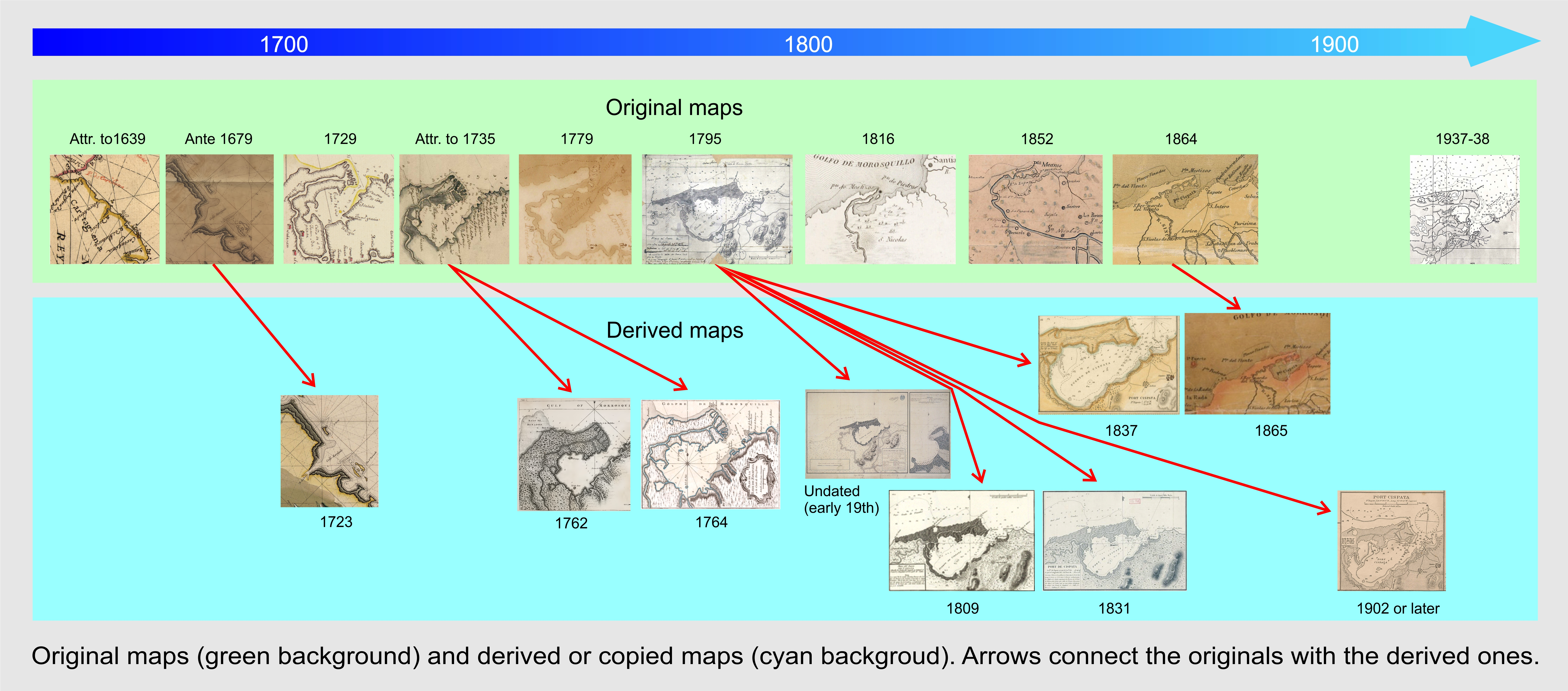
Cispatá bay. (a) Inset of the Kellett and Wood map [13] (1902 or later) from their 1849 map, which, in turn, was copied from Fidalgo’s 1795 map (detail in (b)).
Figure 2.
Cispatá bay. (a) Inset of the Kellett and Wood map [13] (1902 or later) from their 1849 map, which, in turn, was copied from Fidalgo’s 1795 map (detail in (b)).

Figure 3.
Location map of the study area. Present place names with the addition of some 18th century site names mentioned in the text that no longer exist.
Figure 3.
Location map of the study area. Present place names with the addition of some 18th century site names mentioned in the text that no longer exist.

Figure 4.
Simplified geological scheme of the study area. Fault positions are taken from [19].
Figure 4.
Simplified geological scheme of the study area. Fault positions are taken from [19].

Figure 5.
(a) Diego Gutiérrez [31] (the younger, 1562, Spanish, detail) and (b) Cornelius Wytfliet [30] (1597, Dutch, detail).

Figure 6.
(a) Antonio de Herrera y Tordesillas [35] (1601, Spanish, detail); (b) Joannes De Laet [36] (1625, Dutch, detail) and (c) Joan Vingboons [37] (undated, 1639 attributed, Dutch, detail).

Figure 7.
(a) Antonio Pérez Domingo [41] (1729, Spanish, detail); (b) anonymous [45] (very likely by Juan de Herrera y Sotomayor; undated, but attributed to the year 1735) (Spanish, detail); (c) Thomas Jeffereys [43] (1762, English); (d) Jacques Nicolas Bellin [46] (undated, 1764, first ed., French); (e) Antonio de la Torre y Miranda [47] (1774–1778 relief, 1779 ed., Spanish, detail); (f) anonymous, (Jorge Juan de Ulloa? [48], undated, derived from 7b, Spanish, detail) and (g) Jean Bertrand [49] (undated, post-1726? Dutch, detail).


Figure 8.
(a). Cispatà bay. Fidalgo Joaquin [53], 1795 (manuscript map, probably a preprinting sketch, Spanish). (b) Cispatá and the inner bay of Zapote. Fidalgo Joaquín [54] (undated, 1795 relief). (c) Comparison of soundings from ante 1732 Herrera y Sotomayor’s map [45] (or 1762 Jefferys [43]) and 1795 Fidalgo [54] soundings (in red). Converted to meters.

Figure 9.
Codazzi Bartolotti Agostino [57] (1865 ed., Colombian, detail).
Figure 9.
Codazzi Bartolotti Agostino [57] (1865 ed., Colombian, detail).

Figure 10.
(a,b) Ernst Heinrich Michaelis, Alexander von Humboldt, Francisco José de Caldas [58] (1816 ed., 1790–1801 relief, German, detail [61]); (c) anonymous (copy from [62] Joaquín Fidalgo, 1809, Spanish; (d) anonymous [63] (copy from Joaquín Fidalgo, 1831, French); (e) anonymous [64] (copy from Joaquín Fidalgo, 1837, English, inset).


Figure 11.
(a) Kellet and Wood map [13] reporting the magnetic declination for the year 1902, with three insets, one of which represents Port Cispata (undated, 1902 or later, British); (b) a comparison of the 1795 Fidalgo map [53] (upper position) and Kellet and Wood [13] soundings (lower position) reduced to meters in the inset of The Central America map (1902 or later, Spanish/English/USA); and (c) partial update of soundings on a 1902 (or later) map converted to meters: red from the base map and blue from Fidalgo 1795 map.


Figure 12.
Nepomuceno de Santamaría [69] (1852, Colombian, detail).
Figure 12.
Nepomuceno de Santamaría [69] (1852, Colombian, detail).

Figure 13.
Nokomis and Bushnell’s map [72] (1994, from a 1937–1938 relief, USA, detail). The meander of Venados is indicated by the red arrow.
Figure 13.
Nokomis and Bushnell’s map [72] (1994, from a 1937–1938 relief, USA, detail). The meander of Venados is indicated by the red arrow.


© 2020 by the authors. Licensee MDPI, Basel, Switzerland. This article is an open access article distributed under the terms and conditions of the Creative Commons Attribution (CC BY) license (http://creativecommons.org/licenses/by/4.0/).
Share and Cite
MDPI and ACS Style
Piccardi, M.; Correa, I.D.; Pranzini, E. Cispatá Bay and Mestizos Evolution as Reconstructed from Old Documents and Maps (16th–20th Century). J. Mar. Sci. Eng. 2020, 8, 669. https://doi.org/10.3390/jmse8090669
AMA Style
Piccardi M, Correa ID, Pranzini E. Cispatá Bay and Mestizos Evolution as Reconstructed from Old Documents and Maps (16th–20th Century). Journal of Marine Science and Engineering. 2020; 8(9):669. https://doi.org/10.3390/jmse8090669
Chicago/Turabian StylePiccardi, Marco, Ivan D. Correa, and Enzo Pranzini. 2020. "Cispatá Bay and Mestizos Evolution as Reconstructed from Old Documents and Maps (16th–20th Century)" Journal of Marine Science and Engineering 8, no. 9: 669. https://doi.org/10.3390/jmse8090669
Note that from the first issue of 2016, this journal uses article numbers instead of page numbers. See further details here.