

A Review of Historical Volcanic Tsunamis: A New Scheme for a Volcanic Tsunami Monitoring System

1
National Marine Environmental Forecasting Center, Beijing 100081, China
2
Japan Agency for Marine-Earth Science and Technology, Yokohama 236-0001, Japan
*
Author to whom correspondence should be addressed.
J. Mar. Sci. Eng. 2024, 12(2), 278; https://doi.org/10.3390/jmse12020278
Submission received: 9 January 2024
/
Revised: 29 January 2024
/
Accepted: 1 February 2024
/
Published: 3 February 2024
(This article belongs to the Special Issue Marine and Coastal Hazards: Risk Identification, Monitoring, Assessment and Management)
Abstract
:Tsunami monitoring and early warning systems are mainly established to deal with seismogenic tsunamis generated by sudden seafloor fault displacement. However, a global tsunami triggered by the 2022 Tonga volcanic eruption promoted the need for tsunami early warning and hazard mitigation of non-seismogenic tsunamis in coastal countries. This paper studied the spatiotemporal distribution characteristics of historical volcanic tsunamis and summarized high-risk areas of volcanic tsunamis. The circum southwestern Pacific volcanic zone, including the Sunda volcanic belt and the Indo-Australian plate, is a concentrated area of active volcanoes and major volcanic tsunamis. In addition, the challenges associated with adapting seismogenic tsunami techniques for use in the context of volcanic tsunamis were elucidated. At the same time, based on historical records and post-disaster surveys, typical historical volcanic tsunami events and involved mechanisms were summarized. The results show that a majority of volcanic tsunamis may involve multiple generation mechanisms, and some mechanisms show geographical distribution characteristics. The complexity of volcanic tsunami mechanisms poses challenges to tsunami early warning by measuring tsunami sources to evaluate the possible extent of impact, or using numerical modeling to simulate the process of a tsunami. Therefore, a concise overview of the lessons learned and the current status of early warning systems for volcanic tsunamis was provided. Finally, a conceptual scheme of monitoring systems for volcanic tsunamis based on historical volcanoes, real-time volcanic eruption information and sea level data, as well as remote sensing images, was presented.
1. Introduction
Tsunamis may be caused by earthquakes, landslides, volcanic activity, meteorite falls, etc. On 15 January 2022, the Hunga Tonga-Hunga Ha’apai (HTHH) volcano erupted violently and caused a distant tsunami [1,2,3]. The wide scope and impact on various fields of this tsunami have attracted widespread attention around the world [1,4,5].
The generation of a volcanic tsunami is the process of energy transfer from volcanoes to the ocean. The transfer process of energy can be triggered by multiple secondary disasters caused by volcanic activity, such as landslides [6,7], pyroclastic flows [8] and explosions [9]. For example, when a landslide is triggered by volcanic activity, the gravitational potential energy of the landslide body is released into kinetic energy, and the interaction between the landslide and the ocean can generate a tsunami. Volcanic activity can erupt continuously, with a time scale of minutes to hours, and generate tsunamis with different mechanisms. Moreover, volcanic tsunamis are difficult to numerically simulate and often leave only a few minutes for early warning [10,11]. Although the area affected by the volcanic tsunami may cover a relatively limited area, many very large tsunami amplitudes have been monitored in the vicinity of volcanoes [12], which means that they can cause significant hazard to local and regional areas.
A variety of methods have been adopted to analyze volcanic tsunamis, and monitoring technology is the primary support for volcanic tsunami warning and disaster mitigation [13,14,15,16]. The current global tsunami warning system is designed to respond to tsunamis caused by earthquakes and relies on automatic processing of seismic wave data [17]. This kind of system is not suitable for dealing with volcanic tsunamis, as confirmed by the 2022 Tonga tsunami.
The monitoring capacities and tsunami warning needs are different due to the diverse geographical distribution of volcanoes. Currently, there is no global warning system for volcanic tsunamis. To ensure the flight safety of aircrafts, the International Civil Aviation Organization (ICAO) has developed a worldwide network of Volcanic Ash Advisory Centers (VAACs), including nine affiliated agencies, with focus on a particular geographical region individually. The VAACs issue a volcanic ash advisory based on all of the available observations to aviation and meteorological offices. However, the volcanic ash advisory mainly focuses on the volcanic ash and eruption, without analyzing the occurrence of volcanic tsunamis. Meanwhile, due to the complexity of the mechanism of volcanic tsunamis, the tsunami generation mechanism of an identical volcano can differ across different periods. Therefore, it is difficult to assess the tsunami hazard and carry out tsunami warning by measuring volcanic tsunami sources and numerical simulations. There is a clear need to establish a system for monitoring volcanic eruptions and the subsequent tsunami waves.
The purpose of this paper is as follows: (1) analyze the spatiotemporal distribution characteristics of volcanic tsunamis, the high-risk regions of volcanic tsunamis and the different generation mechanisms and disaster characteristics of volcanic tsunamis; (2) design a volcanic tsunami monitoring system by using the volcanic eruption and sea level monitoring data to achieve timely observations and offer a warning service against volcanic tsunamis.
2. Historical Volcanic Tsunami Analysis
To interpret the disaster characteristics of volcanic tsunami events, this study analyzed the spatiotemporal distribution of volcanic eruptions and tsunamis, which can provide data support for the volcanic tsunami monitoring system. The volcanic tsunami data used in this study mainly involve two types: the volcanic eruption data and the global historical tsunami data. The volcanic eruption data are from the Global Volcanism Program (GVP) of the Smithsonian Institution [18]. The volcanic eruption datasets include the eruption time and locations of historical volcanoes since the Holocene and currently active volcanoes, also providing information on eruption type, maximum volcanic explosivity index (VEI), initial and end dates, and the type of evidence for the eruption. A significant eruption is classified when it meets at least one of the following criteria: caused fatalities, caused moderate damage, had a VEI of 6 or larger, caused a tsunami or was associated with a major earthquake. The NCEI/WDS global historical tsunami database collected information on over 2400 tsunami events from 2100 BC to the present [19]. The data information includes the date and location of the tsunami source, cause and validity of the source, tsunami magnitude and intensity, maximum water height, etc.
2.1. Spatial Distribution
This paper analyzed the volcanic eruption data of the GVP, covering the period from 12,000 BC to the present. The data show that the Pacific Rim is the region with the highest number of volcanic eruptions, and there are about 1300 volcanoes that have erupted since the Holocene. Considering the global volcanoes and plate boundaries, it can be seen that most of the volcanoes are located at plate boundaries, especially those along the Pacific Ring of Fire, where more than 95% of the world’s volcanoes are concentrated.
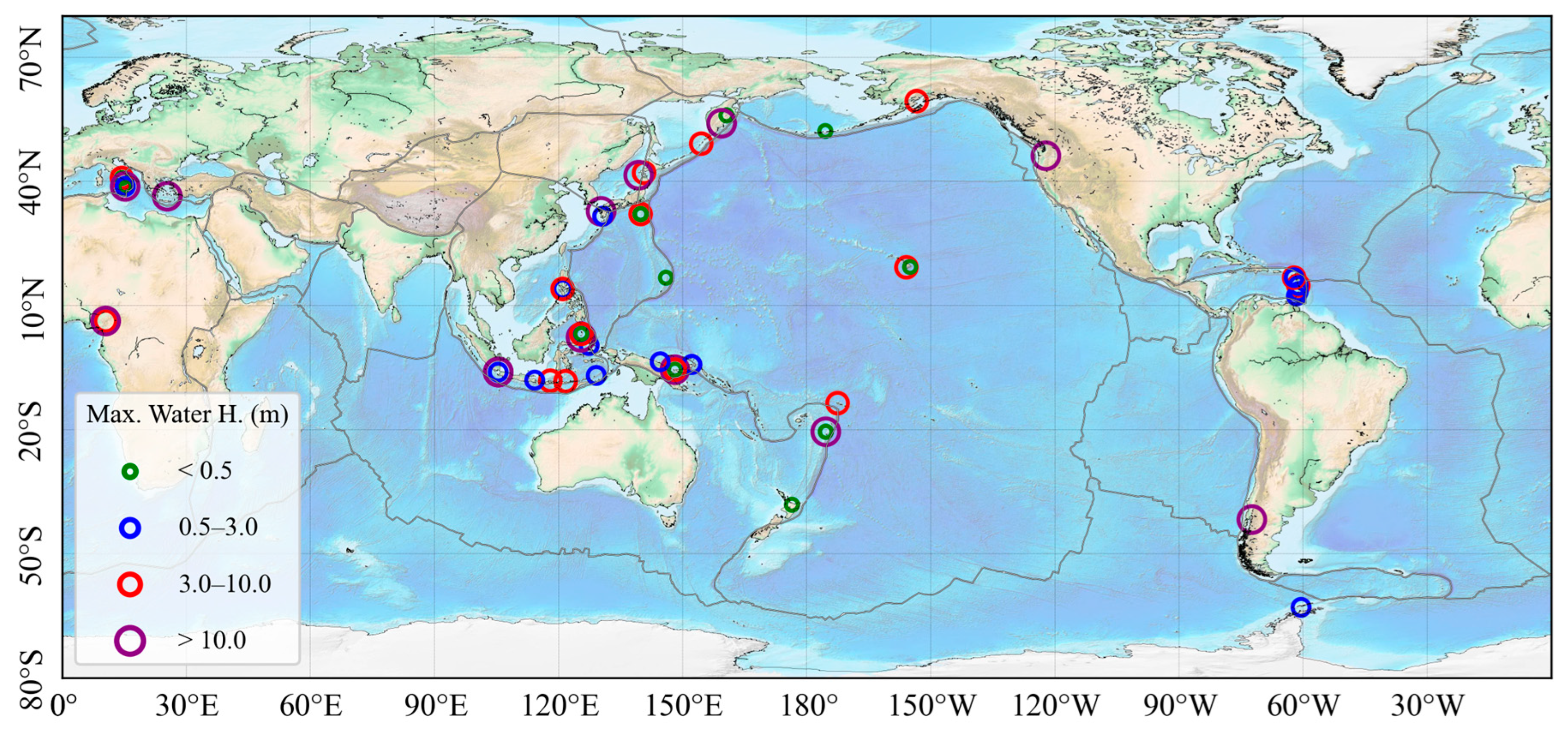
Figure 1 shows the maximum water height distribution of volcano-related tsunami events from the global historical tsunami database [19]. Most of these volcanic tsunami events were concentrated on the west coast of the Pacific Ocean, with a small number of volcanic tsunamis distributed in the Caribbean and the Mediterranean. Also, it is found that nearly half of the maximum wave heights of the volcanic tsunami events were greater than 3 m, which shows the destructive threat potential for volcanic tsunamis. Minor volcanic tsunamis were not recorded may be due to the lack of observation methods. Based on the relationship between the cause of a tsunami and the maximum water height, wave heights are larger on earthquake and landslide tsunamis induced by volcanic activities. The VEI of a volcano that triggers a tsunami is mainly concentrated in the range of 1–5, with a maximum value of 7.
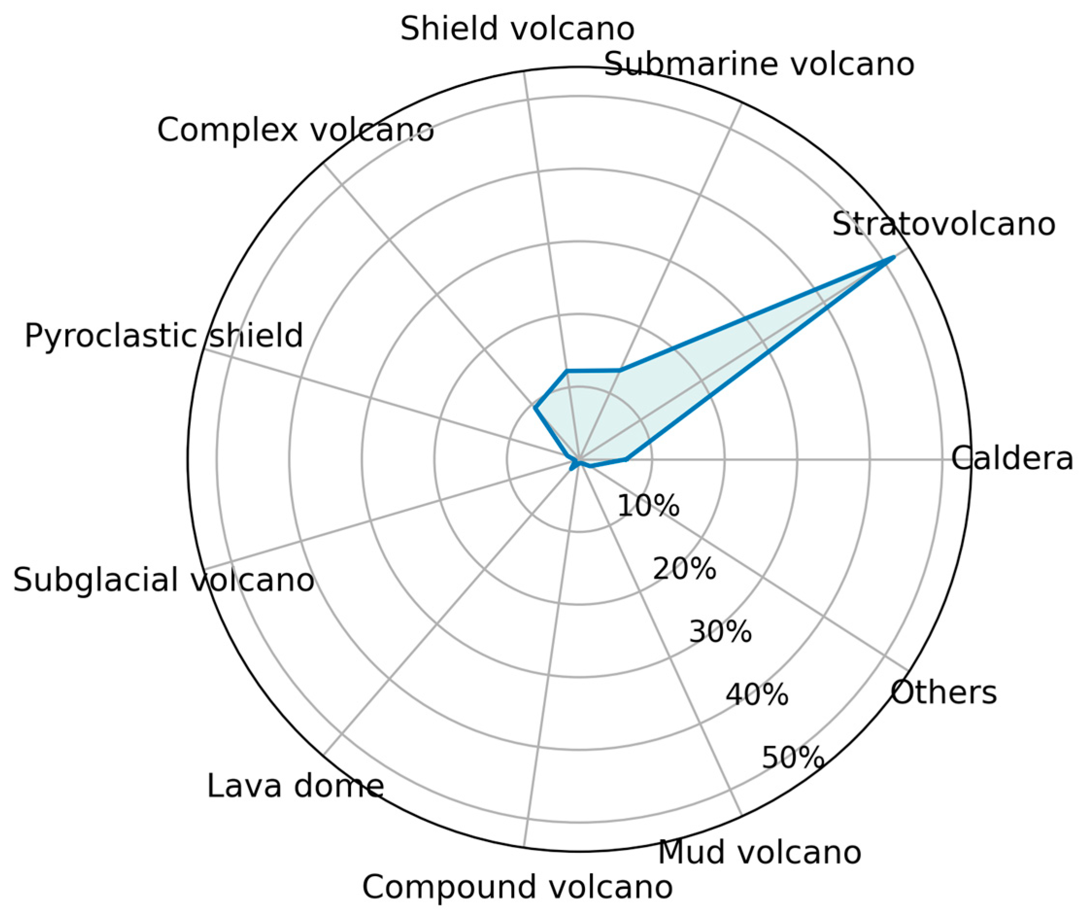
Figure 2 indicates the types of volcanoes that generate tsunamis. Stratovolcano, submarine volcano, shield volcano and complex volcano are the types that produced the most tsunami events. The caldera also generated a number of tsunami events.
2.2. Temporal Analysis
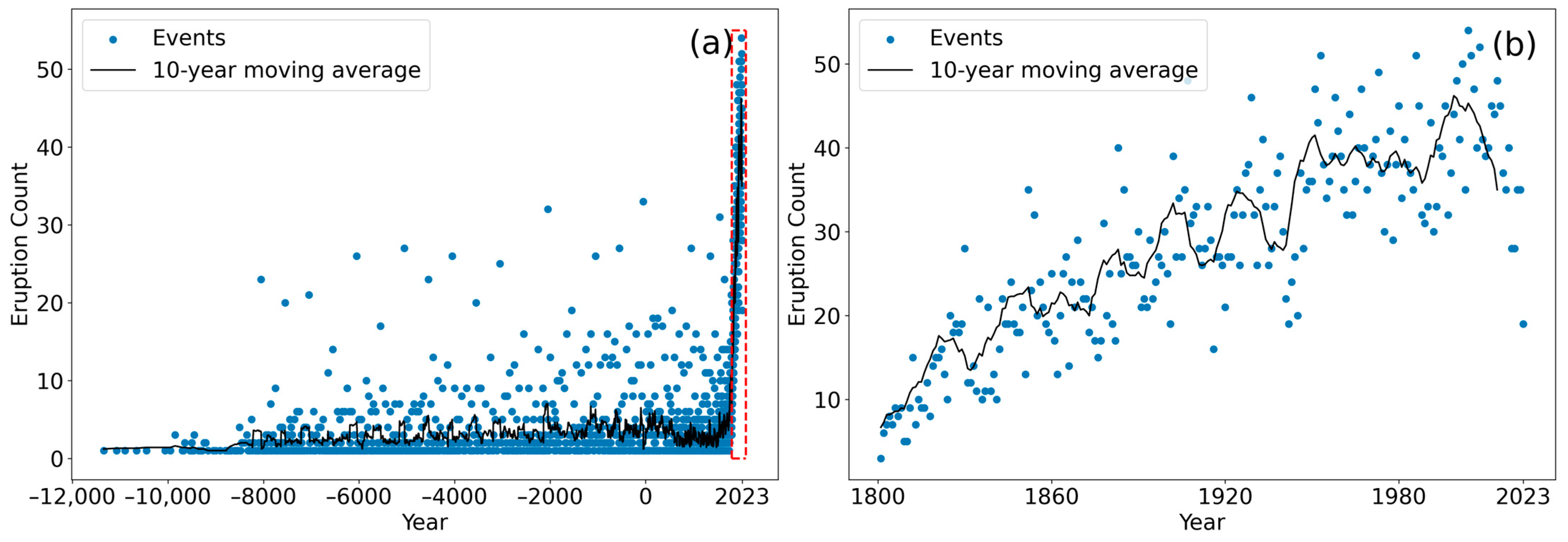
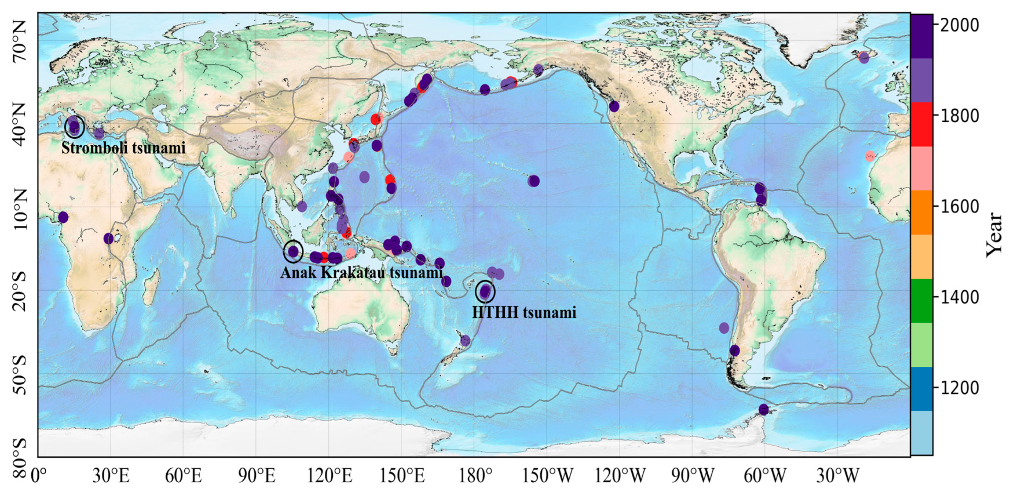
The time of volcanic eruption events from 12,000 BC to the present is shown in Figure 3a. It shows that the number of recorded volcanic eruptions increased sharply from 1800 AD (Figure 3b); with the increase in population and the improvement in communication, volcanic eruption data have been well recorded and preserved. Figure 4 reflects the time distribution of volcanic tsunami events in the NOAA database. As can be seen, volcanic tsunamis have shown a significant increase since the beginning of the 20th century. The number of volcanic tsunamis from the 20th century are more than three times the historical volcanic tsunamis before the 20th century. The western Pacific Rim region has the most volcanic tsunami events in recent years.
2.3. Major Volcanic Tsunamis
The major volcanic tsunami events in the world since 2000 include the Stromboli volcanic tsunami in 2002, the Anak Krakatau volcanic tsunami in 2018, and the HTHH volcanic tsunami in 2022. The maximum tsunami water height of each of the three events exceeded 10 m. The geographical locations are shown in Figure 4.
(1) Stromboli tsunami (2002)
On 30 December 2002, two landslides occurred on the northwestern side of the Stromboli volcano and triggered a tsunami [20]. The tsunami struck the Stromboli Island, spreading over 130 m inland with more than a 10 m high tsunami runup, and destroyed houses severely in many locations, particularly in the northern part of Stromboli [21]. There were two injuries in this event. A variety of new monitoring methods were used during this event to monitor the volcano, including broadband seismographs, GPS networks, side-scan radar, optical radiometers, infrared camera, etc. [22,23].
(2) Anak Krakatau tsunami (2018)
On 22 December 2018, a tsunami struck the coastal areas of the Sunda Strait in Indonesia. There were no signs before the tsunami and no tsunami warning from the authorities. The tsunami caused 437 casualties, 31,943 injured, 10 missing and more than 16,000 people displaced. The damage costs reached to USD 250 million.
The tsunami was caused by the flank collapse of the Anak Krakatau volcano, located in the center of the Sunda Strait [24]. Takabatake et al. [25] investigated the affected areas and showed that the measured inundation height of Cipenyu Beach on the island of Java was more than 10 m. The maximum runup of Panjang island was 83.1 m. Since the Indonesia Tsunami Warning System (InaTEWS) is designed for seismogenic tsunamis, the coastal communities did not receive tsunami warnings during the event.
(3) HTHH tsunami (2022)
On 15 January 2022, a massive explosion occurred at the HTHH volcano in Tonga, leading to a transoceanic tsunami caused by the coupled ocean and atmospheric waves. The tsunami first reached the coast of Tonga and propagated to the shores around the world [26]. The maximum water height was 22 m. The unusual wave characteristics of this tsunami in different places reflect the complexity of the volcanic, atmospheric and oceanic processes [2,26]. There were 6 casualties and 20 injuries during this event, and the total damage cost was about USD 110 million.
The remote sensing technique was used to analyze the volcanic plume, ionospheric disturbances and atmospheric Lamb waves from the volcanic eruption. Satellite data played an important role in monitoring this volcanic tsunami. Several lessons have been learned from this event for volcanic tsunami monitoring and early warning. Rapid tsunami warning and emergency response can help to reduce losses. Therefore, it is necessary to establish a volcanic tsunami warning system, and apply new tsunami monitoring methods such as remote sensing.
3. Mechanism Analysis of Volcanic Tsunamis
3.1. Differences between Volcanic Tsunamis and Seismogenic Tsunamis
Monitoring and early warning of seismogenic tsunamis has long been focused on and studied. In recent years, with the occurrence of non-seismogenic tsunamis, the so-called type of atypical tsunamis have been studied broadly. Different from seismogenic tsunamis, volcanic tsunamis normally occur with a relatively low frequency, only approaching 5%, whereas seismogenic tsunamis have the highest rate of almost 80% [27,28]. However, many historical events have demonstrated that volcanic tsunamis could generate considerable wave heights in local and regional areas. According to the NCEI/WDS, seismogenic tsunamis have caused 510,000 casualties, and volcanic tsunamis have caused more than 50,000 casualties, accounting for about 1/4 of the casualties caused by volcanic activities [19,29,30]. The generation mechanism of volcanic tsunamis is very complex, unlike seismogenic tsunamis which are usually caused by a single mechanism of fault motion. The mechanisms of volcanic tsunamis have been summarized in detail in many studies [30,31,32]. In fact, volcanic tsunamis are generally the result of multiple generation mechanisms, and the more violent the volcanic eruption, the more mechanisms may be involved. Therefore, they pose difficulties in interpreting tsunami signals corresponding to distinct mechanisms in tsunami data, as well as selecting and optimizing tsunami models.
Another difference between volcanic and seismogenic tsunamis is the dominant wave periods. The wave periods of volcanic tsunamis are usually several minutes. However, the wave periods of seismogenic tsunamis are larger, about tens or even hundreds of minutes [33]. Thus, compared with tsunamis triggered by earthquakes, tsunamis associated with volcanic activities have the characteristics of relatively short periods, large dispersion and a limited propagation range [34,35], unless there is a giant flank collapse landslide or explosive volcanic eruption [31]. For example, by comparing the wavelet analysis results of tidal station data of the 2011 Japan earthquake and the 2022 HTHH volcanic tsunami, Hu et al. [36] showed that the volcanic tsunami produced similar far-field tsunami energy and diverse wave period bands and persisted for a long time, in contrast with the seismogenic tsunami.
Tsunami monitoring and early warning for earthquakes are relatively mature [37,38,39], and the current operational ranges for tsunami warning agencies are mainly for seismogenic tsunamis, and most have fixed standard operating procedures. The widely adopted approach is to determine the event information of the submarine source location, magnitude, depth, etc., when an earthquake happens. In accordance with quantitative tsunami scenario-based databases or numerical modeling methods, it is possible to evaluate tsunami generation, launch subsequent early warning operational procedures and then, based on real-time sea level observations, to determine whether a tsunami happens. Thus, it is unlikely to transfer early warning techniques for seismogenic tsunamis to the field of volcanic tsunamis.
Meanwhile, installing, powering and maintaining observation equipment for volcanic islands in the ocean is much more difficult than on land. Therefore, the monitoring conditions also restrict ocean volcano monitoring and early warning [40]. So far, real-time early warning of non-seismogenic tsunamis is still challenging, and how to efficiently establish volcanic tsunami monitoring and early warning has become a vital issue that needs to be resolved.
3.2. Multi-Mechanism Analysis of Volcanic Tsunamis
Due to the concealment of volcanic tsunami generation (mostly underwater explosive eruptions and underwater landslides) and the lack of monitoring, there are difficulties in recording volcanic tsunamis. From 2000 BC to now, there are 64 recorded events that were definitively generated volcanic tsunamis [19]. With the development of underwater investigation and detection technologies, more than 60% of events were recorded in the past century [19]. Based on previous literature records, post-disaster destruction impact and completeness of monitoring data, 37 typical historical volcanic tsunami events and the involved causes in generating the tsunamis were categorized, as shown in Table 1. This table selects the five most common causes related to volcanic tsunamis, namely, volcanic earthquakes, explosions, collapses, pyroclastic flows and landslides. About half of the events show two or more generation mechanisms, among which subaerial and underwater explosive eruptions are both classified as explosive factors, and debris avalanches falling into the sea are classified as landslide mechanisms. Underwater explosions are the most frequent mechanism, accounting for about 25% [29]. However, this mechanism is lower than landslides and pyroclastic flows in records with definite tsunami generation, indicating that there are still certain gaps in the monitoring of underwater explosive tsunamis, which may be underestimated. According to the geographical distribution of these events, the vast majority of volcanic tsunamis are concentrated at the edge of the convergent plate boundary of the western Pacific, and also the Sunda and Philippine Trenches, the Mediterranean sea, the Caribbean Sea, the central Pacific hotspot volcanoes and the west coast of North America. Interestingly, tsunamis due to volcanic landslides and explosions do not show evident characteristics of geographical distribution. However, seismic and pyroclastic flow tsunamis occur more often at the junction of the southwestern Pacific plate. This phenomenon may be related to the regional characteristics of the geological structure and the volcanic magma in the volcanic zone. The circum southwestern Pacific volcanic zone, including the Sunda volcanic belt and the Indo-Australian plate, is a concentrated area of active volcanoes and also a gathering area for major volcanic tsunamis. It is noteworthy that volcanoes at some regions still remain active and have regularly produced multiple volcanic tsunamis, such as Krakatau in Indonesia, Banua Wuhu in Indonesia, Rabaul in Papua New Guinea, Stromboli in Italy, Montserrat in the Caribbean Sea, etc. Although these volcanoes are under long-term monitoring by local agencies, volcanic tsunami disasters are still unavoidable.
The two influential historical events have generated transoceanic tsunamis; one is Krakatau in 1883 and the other is HTHH in 2022. Both explosive eruptions caused widespread atmospheric and tsunami waves which were measured across the oceans globally. A series of tsunami wave components generated by air–sea coupling were recorded and analyzed. Another possible main cause of the two events that is widely considered to be responsible for the severe local and regional tsunami disasters is pyroclastic flow. Maeno and Imamura [8] demonstrated that pyroclastic flows contributed to the majority of the 1883 Krakatau tsunami through methods of numerical simulations. By utilizing ship-mounted acoustic instruments for submarine survey, a scientific team NIWA (National Institute of Water and Atmospheric Research) from New Zealand identified that the HTHH volcano edifice remained almost intact underwater and left traces of erosional channels of pyroclastic flows and volcanic ash deposits on the seafloor, proving that pyroclastic flows were the main mechanism related to the near-field tsunami in Tonga [41]. These studies showed the complexity of volcanic tsunami mechanisms, which need further research. The diversity of volcanic tsunami mechanisms increases the difficulty of separating and interpreting tsunami signals, as well as optimizing numerical models and parameterization schemes. Technique applications for volcanic detection and monitoring and geological investigations of pre- and post-disaster will help us to understand and verify volcanic tsunami mechanisms.
4. Lessons Learned for Volcanic Tsunami Early Warning
Based on the reaction to the early warning and post-disaster field survey of volcanic tsunamis in agencies from different regions, the following points of view are given.
First, it is necessary to establish strong communication and information-sharing mechanisms under existing conditions [42]. Among the tsunami warning centers in countries, especially those centered on active sections of the subduction zone, national tsunami warning centers should set up a good communication channel with their respective coastal emergency management departments. The 2022 Tonga tsunami indicated the importance of real-time data and information sharing during an event. The promotion and application of public information sharing platforms within and between countries, encouraging end-to-end participation of departments at all levels in the early warning system, and even the media and the public, to share data and disaster information in real time through online media will greatly benefit coordination and cooperation of early warning and emergency response, post-disaster investigation and scientific research [43]. Also, connections between academic agencies and the operational community should be improved. For example, the potential structural instability and tsunami risk of Anak Krakatau had been pointed out in 2012 [44], long before the volcanic tsunami of Anak Krakatau occurred in 2018.
Second, monitoring volcanic eruptions and sea level fluctuations are prerequisites for volcanic tsunami early warning and hazard mitigation. A variety of monitoring techniques have been studied [6,7,45,46]. Current techniques for volcanic eruption observations mainly consist of earthquake monitoring, ground deformation monitoring, gas emission monitoring, thermal imaging and remote sensing. Seismic instruments are used to detect ground vibrations caused by volcanic activities, such as magma movement or rock fracture. Changes in seismic activity, including the frequency and magnitude of earthquakes, can provide insight into the movement of magma beneath the surface and indicate possible eruptions [47,48]. Volcanic activity can cause ground deformation due to magma movement. Instruments such as GPS and satellite radar can measure volcanic ground deformation to help scientists understand the possibility of magma migration and eruption [49,50]. Before a volcanic eruption, volcanic gases like sulfur dioxide and carbon dioxide may be released in large quantities. Gas monitoring may help to assess the accumulation of pressure inside the volcano and provide information about the rise in magma [51]. Temperature changes on the volcanic surface can be detected by infrared cameras, and rises in temperature may imply magma moving toward the surface. At the same time, satellites equipped with various sensors can provide valuable information about activities such as thermal anomalies, gas emissions and ground deformation of a remote volcano island [52]. Relying on the integration of interdisciplinary research, the incorporation of more extensive monitoring approaches, and the calibration and development of numerical modeling in volcanic eruption and tsunamis are also key factors for the operationalization of tsunami early warning services. Some routine operational monitoring services for active volcanoes have achieved good early warning effects, such as the combination of pressure sensors and marine noise identification algorithms currently used at Stromboli volcano, which detected the volcanic tsunamis generated by Stromboli in 2019 and 2021. InaTEWS has integrated and operationally runs several inexpensive sea-level devices (IDSL) and plans to build a network of 500 IDSL in the future [53]. This device can monitor sea levels in real time and is suitable for countries like Indonesia that have regional near-source tsunami risks. It can strengthen the ability of the tsunami early warning systems [54]. Han et al. [55] used CubeSat GPS to detect ionospheric disturbances in the propagation of the atmospheric waves generated by the 2022 Tonga volcanic explosion, revealing the application potential of atmospheric remote sensing in tsunami warning. The scheme of tsunami early warning based on real-time measurements of hydro-acoustic waves has been proven to be effective and can be used as a supplement to the operational tsunami early warning method in the future [56]. If the continental shelf width is large enough, high-frequency ocean radar can capture the first appearance of tsunami currents at the shelf edge, and this also may be used to support a tsunami early warning system [57]. Supplemental tsunami monitoring data can support the optimization of numerical models, enabling non-seismogenic tsunami models to be embedded in early warning systems for application.
Additionally, the volcanic tsunami sources are usually close to the coastline in many areas, which may not lead to enough time for tsunami early warning. For example, the first large tsunami wave from the 2022 Tonga volcano had hit the western coast of Tongatapu in 30 min without the issuing of a tsunami warning. Therefore, the public cannot rely too much on tsunami warning. Education and outreach, as well as the enhancement of self-evacuation capabilities are also very important.
5. A Scheme for Volcanic Tsunami Monitoring Systems
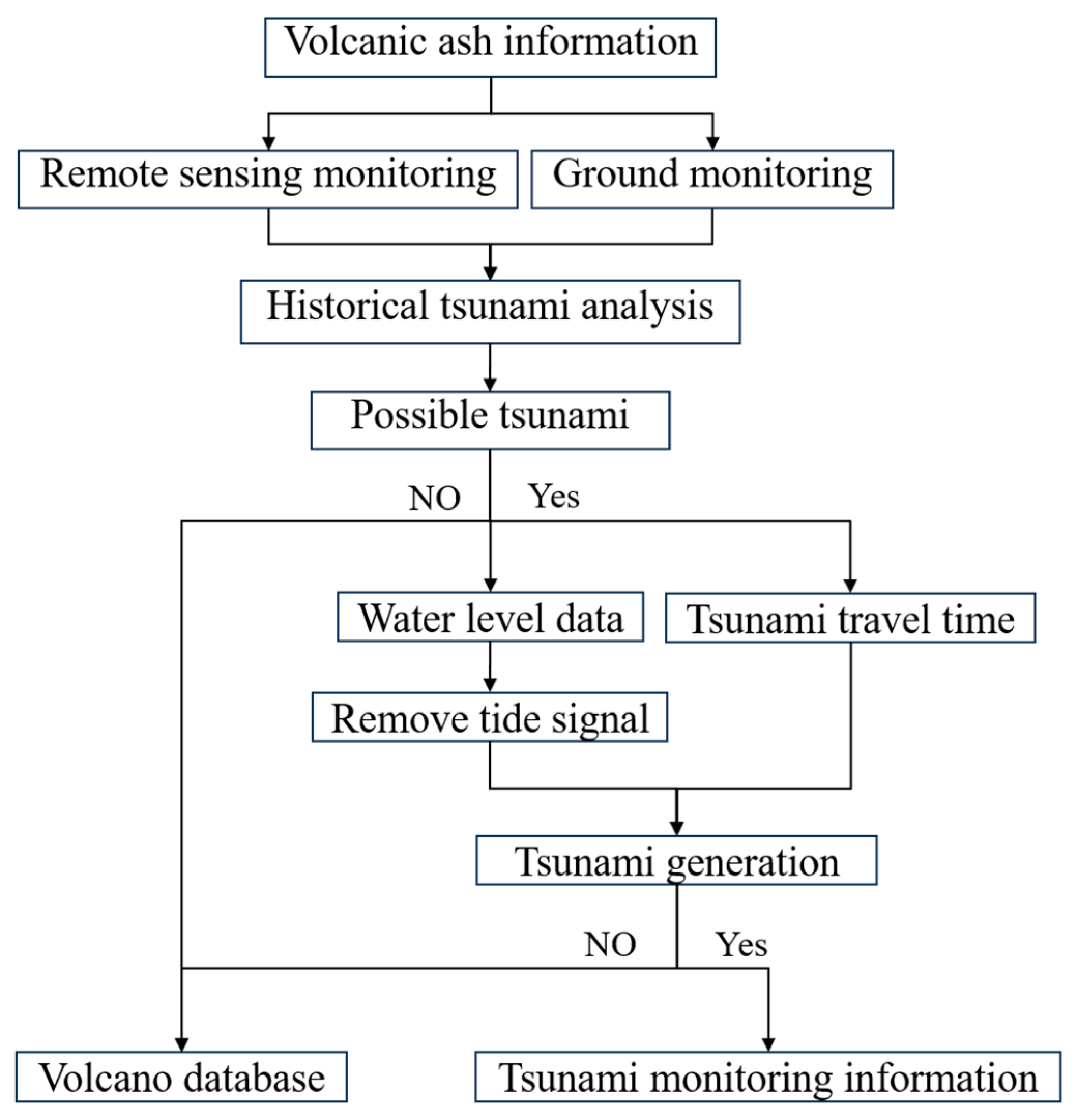
Improvements in identifying volcanoes with a single generation mechanism have been studied, for example, an early warning system for tsunamis was developed for the collapse of Anak Krakatau volcano, Indonesia [58]. Based on the analysis of previous sections, the complexity and diversity of generation mechanisms of volcanic tsunamis may lead to difficulties in evaluating the tsunami characteristics. A preliminary monitoring system regardless of the generation mechanisms for volcanic tsunamis is proposed. A hypothetical scheme for the determination of volcanic tsunamis by integrating volcanic eruption monitoring, historical record analysis, remote sensing images and sea level monitoring data is given.
Figure 5 shows the framework of the volcanic tsunami monitoring system, which mainly includes three parts: volcanic eruption monitoring, historical data analysis and tsunami wave monitoring. After receiving the volcanic ash advisory information with confirmation of volcanic eruption from a VAAC, the occurrence of a volcanic tsunami is determined by analyzing the historical volcanic tsunamis, volcanic eruption monitoring and the characteristics of tsunami waves.
(1) Volcanic eruption monitoring
For volcanoes with high risk or confirmation of eruptions, volcanic ash information is obtained in near-real time from the websites of VAACs. After receiving the eruption information, the meteorological satellite data and ground monitoring equipment (seismographs and cameras) are used to monitor volcanic eruptions, and the hazard of volcanic eruption is preliminarily analyzed.
The volcano ash can be monitored by infrared remote sensing data which come from Himawari 8/9, GOES and Modis, while volcano lava could be monitored by near-infrared bands from EO-1, Landsat-8 and Sentinel-2. Ground monitoring methods should include all of the state-of-art instruments that can monitor volcanic activity. Seismometers can be used to measure earthquakes occurring near an eruption. Tiltmeters and GPS satellites are used to monitor any ground deformation. Gas-trapping bottles can be used to capture gases such as carbon dioxide (CO2) and sulfur dioxide (SO2) from volcanic eruptions.
(2) Historical events database
Historical volcanic data were retrieved from the database and used to analyze the relationship between historical volcanic activities and tsunamis. When a volcanic eruption potential occurs, it is helpful to assess whether the volcanic eruption can cause a tsunami as well as the mechanism that may be involved and the extent of the eruption and tsunami. Historical data are derived from the GVP eruption data and the NOAA historical tsunami database.
(3) Tsunami wave monitoring
The real-time monitoring data from tidal stations and buoys around the volcano are used to analyze tsunami waves. Currently, the Global Sea Level Observing System (GLOSS) provides real-time sea level data from more than 600 stations. A high-pass filter is used to remove the tide from sea level data. If a tsunami wave greater than 5 cm is detected at multiple stations adjacent to the volcano, it can be confirmed that there is a tsunami. The tsunami travel time is then calculated and compared with the arrival times of observed tsunami waves to analyze whether the volcanic eruption may have caused a tsunami. If the tsunami travel time from the volcano and the tsunami arrival are consistent, the volcanic eruption is likely to have caused a tsunami. Then, the tsunami monitoring information is released in a short time.
6. Discussion
A volcanic tsunami monitoring and warning system should be established according to the characteristics of volcanic tsunamis. Some volcanoes are located in inaccessible regions, making it inconvenient to install monitoring instruments on site. In this paper, a volcanic tsunami monitoring system is proposed by using volcanic eruption information and water level data. This system utilizes the long-term monitoring characteristics of remote sensing monitoring to detect volcanic eruptions.
This scheme for a volcanic monitoring system is designed especially for volcanoes with limited eruption observation tools. However, the design has several limitations. (1) Some volcanic eruption events with tectonic activities or underwater sites have less volcanic ash and may not be monitored by remote sensing data. Some volcanic eruptions may be missed. Therefore, more ground monitoring instruments should be deployed to supplement volcanic eruption monitoring and address the limitations of remote sensing data. (2) Sea level monitoring is limited by the location of measuring stations. Tsunami waves cannot be monitored in areas without sea level stations, which may affect the timely monitoring of volcanic tsunamis. Hydrophones, cabled bottom pressure sensors, buoys and satellite SAR data can be used as supplements to monitor the tsunami wave. (3) Remote sensing may be affected by weather conditions when monitoring volcanic eruptions. (4) The time latency from volcanic ash observation to volcanic ash advisory issuance is about 20 min on average. It also takes approximately 10 min to analyze the historical tsunamis and produce tsunami monitoring information. Therefore, the total time would be approximately 30 min. Compared with the automatic seismogenic tsunami early warning message issuance time, it still needs improvement.
7. Conclusions
The spatiotemporal distribution of historical volcanic eruptions and tsunamis was analyzed. The western Pacific is a high-risk area for volcanic tsunamis. Seismogenic and landslide tsunamis induced by volcanic activities tend to generate larger tsunami wave heights. Analysis of typical historical volcanic tsunami events reveals that a majority of volcanic tsunamis may involve multiple generation mechanisms, and some mechanisms show systematic geographical distribution characteristics. The monitoring of volcanic eruptions and tsunamis is essential for volcanic tsunami warning and disaster mitigation. Current volcanic tsunami early warning status and post-disaster lessons learnt from operational communities are reviewed. Based on these results, a conceptual volcanic tsunami monitoring system is proposed. This system can achieve the monitoring of volcanic tsunami events in a short time by integrating volcanic ash information, historical tsunami analysis, remote sensing monitoring and tsunami wave monitoring.
Author Contributions
Conceptualization, T.F. and J.H.; formal analysis, T.F. and Y.W.; writing, T.F. and Z.X.; review and editing, L.S. and P.W. All authors have read and agreed to the published version of the manuscript.
Funding
This research was funded by the National Key R&D Program of China under contract (No. 2022YFC3003804) and the China–Indonesia Marine and Climate Center Development (No. 121152000000210003).
Institutional Review Board Statement
Not applicable.
Informed Consent Statement
Not applicable.
Data Availability Statement
The data are available upon request from the corresponding author.
Acknowledgments
The authors gratefully acknowledge the helpful suggestions from three conscientious reviewers.
Conflicts of Interest
The authors declare no conflicts of interest.
References
- Kubota, T.; Saito, T.; Nishida, K. Global fast-traveling tsunamis driven by atmospheric Lamb waves on the 2022 Tonga eruption. Science 2022, 377, 91–94. [Google Scholar] [CrossRef]
- Carvajal, M.; Sepúlveda, I.; Gubler, A.; Garreaud, R. Worldwide signature of the 2022 Tonga volcanic tsunami. Geophys. Res. Lett. 2022, 49, e2022GL098153. [Google Scholar] [CrossRef]
- Wang, Y.; Wang, P.; Kong, H.; Wong, C. Tsunamis in Lingding Bay, China, caused by the 2022 Tonga volcanic eruption. Geophys. J. Int. 2023, 232, 2175–2185. [Google Scholar] [CrossRef]
- Matoza, R.; Fee, D.; Assink, J.; Iezzi, A.; Green, D.; Kim, K.; Toney, L.; Lecocq, T.; Krishnamoorthy, S.; Lalande, J.-M.; et al. Atmospheric waves and global seismoacoustic observations of the January 2022 Hunga eruption, Tonga. Science 2022, 377, 95–100. [Google Scholar] [CrossRef]
- Ramírez-Herrera, M.; Coca, O.; Vargas-Espinosa, V. Tsunami effects on the Coast of Mexico by the Hunga Tonga-Hunga Ha’apai volcano eruption, Tonga. Pure Appl. Geophys. 2022, 179, 1117–1137. [Google Scholar] [CrossRef]
- Waythomas, C.; Watts, P.; Shi, F.; Kirby, J. Pacific Basin tsunami hazards associated with mass flows in the Aleutian arc of Alaska. Quat. Sci. Rev. 2009, 28, 1006–1019. [Google Scholar] [CrossRef]
- Kelfoun, K.; Giachetti, T.; Labazuy, P. Landslide-generated tsunamis at Reunion Island. J. Geophys. Res. 2010, 115, F04012. [Google Scholar] [CrossRef]
- Maeno, F.; Imamura, F. Tsunami generation by a rapid entrance of pyroclastic flow into the sea during the 1883 Krakatau eruption, Indonesia. J. Geophys. Res. Solid Earth 2011, 116, B09205. [Google Scholar] [CrossRef]
- Mader, C.L.; Gittings, M.L. Numerical model for the Krakatoa hydrovolcanic explosion and tsunami. Sci. Tsunami Hazards 2006, 24, 174–182. [Google Scholar]
- Bellotti, G.; Di Risio, M.; De Girolamo, P. Feasibility of tsunami early warning systems for small volcanic islands. Nat. Hazards Earth Syst. Sci. 2009, 9, 1911–1919. [Google Scholar] [CrossRef]
- Ulvrová, M.; Paris, R.; Kelfoun, K.; Nomikou, P. Numerical simulations of tsunamis generated by underwater volcanic explosions at Karymskoye Lake (Kamchatka, Russia) and Kolumbo volcano (Aegean Sea, Greece). Nat. Hazards Earth Syst. Sci. 2014, 14, 401–412. [Google Scholar] [CrossRef]
- Ren, Z.; Wang, Y.; Wang, P.; Hou, J.; Gao, Y.; Zhao, L. Numerical study of the triggering mechanism of the 2018 Anak Krakatau tsunami: Eruption or collapsed landslide? Nat. Hazards 2020, 102, 1–13. [Google Scholar] [CrossRef]
- Baldi, P.; Coltelli, M.; Fabris, M.; Marsella, M.; Tommasi, P. High precision photogrammetry for monitoring the evolution of the NW flank of Stromboli volcano during and after the 2002–2003 eruption. Bull. Volcanol. 2008, 70, 703–715. [Google Scholar] [CrossRef]
- Otsuka, S. Visualizing Lamb waves from a volcanic eruption using meteorological satellite Himawari-8. Geophys. Res. Lett. 2022, 49, e2022GL098324. [Google Scholar] [CrossRef]
- Themens, D.; Watson, C.; Žagar, N.; Vasylkevych, S.; Elvidge, S.; McCaffrey, A.; Prikryl, P.; Reid, B.; Wood, A.; Jayachandran, P. Global propagation of ionospheric disturbances associated with the 2022 Tonga volcanic eruption. Geophys. Res. Lett. 2022, 49, e2022GL098158. [Google Scholar] [CrossRef]
- Carr, J.; Horváth, Á.; Wu, D.; Friberg, M. Stereo plume height and motion retrievals for the record-setting Hunga Tonga-Hunga Ha’apai eruption of 15 January 2022. Geophys. Res. Lett. 2022, 49, e2022GL098131. [Google Scholar] [CrossRef]
- Bernard, E.; Titov, V. Evolution of tsunami warning systems and products. Philos. Trans. Royal Soc. A-Math. Phys. Eng. Sci. 2015, 373, 20140371. [Google Scholar] [CrossRef]
- Global Volcanism Program, 2023. [Database] Volcanoes of the World (v. 5.1.5; 15 December 2023). Distributed by Smithsonian Institution, Compiled by Venzke, E. Available online: https://volcano.si.edu/gvp_votw.cfm (accessed on 9 January 2024).
- National Geophysical Data Center/World Data Service: NCEI/WDS Global Historical Tsunami Database. NOAA National Centers for Environmental Information. 1 November 2023. Available online: https://data.noaa.gov/metaview/page?xml=NOAA/NESDIS/NGDC/MGG/Hazards/iso/xml/G02151.xml&view=getDataView (accessed on 9 January 2024).
- Bonaccorso, A.; Calvari, S.; Garfì, G.; Lodato, L.; Patanè, D. Dynamics of the December 2002 flank failure and tsunami at Stromboli volcano inferred by volcanological and geophysical observations. Geophys. Res. Lett. 2003, 30, 1941. [Google Scholar] [CrossRef]
- Tinti, S.; Pagnoni, G.; Zaniboni, F.; Bortolucci, E. Tsunami generation in Stromboli island and impact on the south-east Tyrrhenian coasts. Nat. Hazards Earth Syst. Sci. 2003, 3, 299–309. [Google Scholar] [CrossRef]
- Ripepe, M.; Harris, A.; Carniel, R. Thermal, seismic and infrasonic evidences of variable degassing rates at Stromboli volcano. J. Volcanol. Geoth. Res. 2002, 118, 285–297. [Google Scholar] [CrossRef]
- Nolesini, T.; Di Traglia, F.; Del Ventisette, C.; Moretti, S.; Casagli, N. Deformations and slope instability on Stromboli volcano: Integration of GBInSAR data and analog modeling. Geomorphology 2013, 180, 242–254. [Google Scholar] [CrossRef]
- Esteban, M.; Takabatake, T.; Achiari, H.; Mikami, T.; Nakamura, R.; Gelfi, M.; Panalaran, S.; Nishida, Y.; Inagaki, N.; Chadwick, C.; et al. Field Survey of Flank Collapse and Run-up Heights due to 2018 Anak Krakatau Tsunami. J. Coast. Hydraul. Struct. 2021, 1, 1. [Google Scholar] [CrossRef]
- Takabatake, T.; Shibayama, T.; Esteban, M.; Achiari, H.; Nurisman, N.; Gelfi, M.; Tarigan, T.; Kencana, E.; Fauzi, M.; Panalaran, S.; et al. Field survey and evacuation behaviour during the 2018 Sunda Strait tsunami. Coast. Eng. J. 2019, 61, 423–443. [Google Scholar] [CrossRef]
- Omira, R.; Ramalho, R.; Kim, J.; González, P.; Kadri, U.; Miranda, J.; Carrilho, F.; Baptista, M. Global Tonga tsunami explained by a fast-moving atmospheric source. Nature 2022, 609, 734–740. [Google Scholar] [CrossRef] [PubMed]
- Gusiakov, V. Tsunami history: Recorded. Sea 2009, 15, 23–53. [Google Scholar]
- Reid, J.; Mooney, W. Tsunami occurrence 1900–2020: A global review, with examples from Indonesia. Pure Appl. Geophys. 2023, 180, 1549–1571. [Google Scholar] [CrossRef]
- Paris, R.; Switzer, A.; Belousova, M.; Belousov, A.; Ontowirjo, B.; Whelley, P.; Ulvrova, M. Volcanic tsunami: A review of source mechanisms, past events and hazards in Southeast Asia (Indonesia, Philippines, Papua New Guinea). Nat. Hazards 2014, 70, 447–470. [Google Scholar] [CrossRef]
- Latter, J. Tsunamis of volcanic origin: Summary of causes, with particular reference to Krakatoa, 1883. Bull. Volcanol. 1981, 44, 467–490. [Google Scholar] [CrossRef]
- Day, S. Volcanic tsunamis. In The Encyclopedia of Volcanoes; Academic Press: Cambridge, MA, USA, 2015; pp. 993–1009. [Google Scholar]
- Paris, R. Source mechanisms of volcanic tsunamis. Philos. Trans. R. Soc. A Math. Phys. Eng. Sci. 2015, 373, 20140380. [Google Scholar] [CrossRef]
- Hou, J.; Yuan, Y.; Wang, P.; Ren, Z.; Li, X. Development of a decision support system for tsunami evacuation: Application to the Jiyang District of Sanya city in China. Nat. Hazards Earth Syst. Sci. 2017, 17, 335–343. [Google Scholar] [CrossRef]
- Okal, E.; Synolakis, C. Source discriminants for near-field tsunamis. Geophys. J. Int. 2004, 158, 899–912. [Google Scholar] [CrossRef]
- Harbitz, C.; Løvholt, F.; Pedersen, G.; Masson, D. Mechanisms of tsunami generation by submarine landslides: A short review. Nor. J. Geol. 2006, 86, 255–264. [Google Scholar]
- Hu, G.; Li, L.; Ren, Z.; Zhang, K. The characteristics of the 2022 Tonga volcanic tsunami in the Pacific Ocean. Nat. Hazards Earth Syst. Sci. 2023, 23, 675–691. [Google Scholar] [CrossRef]
- Wei, Y.; Chamberlin, C.; Titov, V.; Tang, L.; Bernard, E. Modeling of the 2011 Japan tsunami: Lessons for near-field forecast. Pure Appl. Geophys. 2013, 170, 1309–1331. [Google Scholar] [CrossRef]
- Wu, T. Deterministic study on the potential large tsunami hazard in Taiwan. J. Earthq. Tsunami 2012, 6, 1250034. [Google Scholar] [CrossRef]
- Fan, T.; Hou, J.; Xu, Z.; Wang, Y.; Zhao, L.; Gao, Y.; Wang, P. Investigation of Local Tsunami Effect on Coastal Areas: A Case Study of Putian City, Fujian Province, China. Sustainability 2022, 15, 415. [Google Scholar] [CrossRef]
- Gu, G.; Guan, S.; Han, D.; Pan, X.; Song, Y. A Preliminary Study of Crater Collapse in Hunga Haapai, Tonga. J. Disast. Prev. Reduct. 2022, 38, 24–30. (In Chinese) [Google Scholar]
- Mackay, K.; Clark, M.; Seabrook, S.; Armstrong, E.; Barr, N.; Frontin-Rollet, G.; George, S.; Hoffmann, L.; Macpherson, D.; McInerney, J.; et al. Environmental Impacts of the 2022 Eruption of Hunga Tonga-Hunga Ha’apai: Voyage Report of Part 1 of the TesMAP Survey of the Region in April–May 2022 (TAN2206); NIWA Technical Report No. 141; NIWA: Auckland, New Zealand, 2022; p. 197. [Google Scholar]
- Mersham, G. Social media and public information management: The September 2009 tsunami threat to New Zealand. Media Int. Aust. 2010, 137, 130–143. [Google Scholar] [CrossRef]
- Moore, A.; Jean, C.; Korfmacher, M.; Vickery, J.; Bostrom, A.; Errett, N. Coastal Emergency Managers’ Risk Perception and Decision Making for the Tonga Distant Tsunami. Available online: https://papers.ssrn.com/sol3/papers.cfm?abstract_id=4665178 (accessed on 9 January 2024).
- Giachetti, T.; Paris, R.; Kelfoun, K.; Ontowirjo, B. Tsunami Hazard Related to a Flank Collapse of Anak Krakatau Volcano, Sunda Strait, Indonesia; Geological Society, Special Publications: London, UK, 2012; Volume 361, pp. 79–90. [Google Scholar]
- Maramai, A.; Graziani, L.; Alessio, G.; Burrato, P.; Colini, L.; Cucci, L.; Nappi, R.; Nardi, A.; Vilardo, G. Near-and far-field survey report of the 30 December 2002 Stromboli (Southern Italy) tsunami. Mar. Geol. 2005, 215, 93–106. [Google Scholar] [CrossRef]
- Fritz, H.; Kalligeris, N.; Borrero, J.; Broncano, P.; Ortega, E. The 15 August 2007 Peru tsunami runup observations and modeling. Geophys. Res. Lett. 2008, 35, L10604-4. [Google Scholar] [CrossRef]
- Roman, D.; Soldati, A.; Dingwell, D.; Houghton, B.; Shiro, B. Earthquakes indicated magma viscosity during Kīlauea’s 2018 eruption. Nature 2021, 592, 237–241. [Google Scholar] [CrossRef] [PubMed]
- De Angelis, S.; Henton, S. On the feasibility of magma fracture within volcanic conduits: Constraints from earthquake data and empirical modelling of magma viscosity. Geophys. Res. Lett. 2011, 38, L19310. [Google Scholar] [CrossRef]
- Larson, K.; Poland, M.; Miklius, A. Volcano monitoring using GPS: Developing data analysis strategies based on the June 2007 Kīlauea Volcano intrusion and eruption. J. Geophys. Res. Solid Earth 2010, 115, B07406. [Google Scholar] [CrossRef]
- Janssen, V. Volcano deformation monitoring using GPS. J. Spatial Sci. 2007, 52, 41–54. [Google Scholar] [CrossRef]
- Fischer, T.; Ramírez, C.; Mora-Amador, R.; Hilton, D.; Barnes, J.; Sharp, Z.; Le Brun, M.; de Moor, J.; Barry, P.; Füri, E.; et al. Temporal variations in fumarole gas chemistry at Poás volcano, Costa Rica. J. Volcanol. Geotherm. Res. 2015, 294, 56–70. [Google Scholar] [CrossRef]
- Anantrasirichai, N.; Biggs, J.; Albino, F.; Bull, D. A deep learning approach to detecting volcano deformation from satellite imagery using synthetic datasets. Remote Sens. Environ. 2019, 230, 111179. [Google Scholar] [CrossRef]
- Necmioglu, O.; Chang Seng, D.; Annunziato, A.; Imperiali, O. JRC/DG-ECHO/UNESCO-IOC Joint Hybrid-Workshop on Local Tsunami Warning in the Context of Multi-Hazard Disaster Risk Mitigation; Publications Office of the European Union: Luxembourg, 2023. [Google Scholar] [CrossRef]
- Husrin, S.; Annunziato, A.; Prasetya, G.; Hidayat, R. IDSL for Tsunami Early Warning System in Indonesia. In Proceedings of the IOP Conference Series: Earth and Environmental Science 4th International Conference on Civil and Environmental Engineering, Bali, Indonesia, 3–5 August 2022. [Google Scholar]
- Han, S.-C.; McClusky, S.; Mikesell, T.; Rolland, L.; Okal, E.; Benson, C. CubeSat GPS observation of traveling ionospheric disturbances after the 2022 Hunga-Tonga Hunga-Ha’apai volcanic eruption and its potential use for tsunami warning. Earth Space Sci. 2023, 10, e2022EA002586. [Google Scholar] [CrossRef]
- Cecioni, C.; Bellotti, G.; Romano, A.; Abdolali, A.; Sammarco, P.; Franco, L. Tsunami early warning system based on real-time measurements of hydro-acoustic waves. Procedia Eng. 2014, 70, 311–320. [Google Scholar] [CrossRef]
- Dzvonkovskaya, A.; Petersen, L.; Helzel, T.; Kniephoff, M. High-frequency ocean radar support for Tsunami Early Warning Systems. Geosci. Lett. 2018, 5, 29. [Google Scholar] [CrossRef]
- Ratnasari, R.; Tanioka, Y.; Yamanaka, Y.; Mulia, I. Development of Early Warning System for Tsunamis Accompanied by Collapse of Anak Krakatau Volcano, Indonesia. Front. Earth Sci. 2023, 11, 1213493. [Google Scholar] [CrossRef]
Figure 1.
Maximum water height distribution of volcanic tsunamis.

Figure 2.
Types of volcanoes that generate tsunamis.

Figure 3.
(a) Volcanic eruptions over time from 12,000 BC to present. The red dashed box shows the time range from 1800 to present. (b) Volcanic eruptions over time from 1800 to present.
Figure 3.
(a) Volcanic eruptions over time from 12,000 BC to present. The red dashed box shows the time range from 1800 to present. (b) Volcanic eruptions over time from 1800 to present.

Figure 4.
Volcanic tsunamis’ occurrence time.

Figure 5.
Framework of a volcanic tsunami monitoring system.


Table 1.
Representative major volcanic tsunami events in history and their associated mechanisms.
| No. | Year | Volcano | Earthquake | Explosive Eruption | Caldera Collapse | Pyroclastic Flow | Flank Failure/ Landslide |
|---|---|---|---|---|---|---|---|
| 1 | 1640 | Komagatake | √ | ||||
| 2 | 1650 | Kolumbo | Submarine | √ | |||
| 3 | 1673 | Gamkonora | √ 1 | √ | |||
| 4 | 1716 | Taal | Submarine | ||||
| 5 | 1741 | Oshima-Oshima | √ | ||||
| 6 | 1792 | Mount Unzen | √ | √ | |||
| 7 | 1815 | Tambora | √ | √ | |||
| 8 | 1856 | Awu | √ | ||||
| 9 | 1857 | Umboi | √ | ||||
| 10 | 1868 | Kilauea and Mauna Loa | √ | ||||
| 11 | 1871 | Ruang | √ | ||||
| 12 | 1878 | Tanna Island | √ | √ | |||
| 13 | 1878 | Rabaul | √ | ||||
| 14 | 1883 | Augustine | √ | ||||
| 15 | 1883 | Krakatau | √ | √ | √ | √ | √ |
| 16 | 1888 | Ritter | √ | ||||
| 17 | 1889 | Sangihe | √ | ||||
| 18 | 1918 | Banua Wuhu | Submarine | ||||
| 19 | 1919 | Banua Wuhu | Submarine | ||||
| 20 | 1928 | Paluweh | √ | √ | |||
| 21 | 1928 | Krakatau | Submarine | ||||
| 22 | 1930 | Krakatau | Submarine | ||||
| 23 | 1937 | Rabaul | √ | √ | √ | ||
| 24 | 1939 | Kick ’em Jenny | Submarine | √ | |||
| 25 | 1952 | Myojin-Sho | Submarine | ||||
| 26 | 1966 | Tinakula | √ | ||||
| 27 | 1971 | Tinakula | √ | √ | |||
| 28 | 1975 | Kilauea | √ | √ | |||
| 29 | 1979 | Iliwerung | √ | ||||
| 30 | 1994 | Rabaul | √ | √ | |||
| 31 | 1996 | Karymsky Lake | Submarine | ||||
| 32 | 1997 | Montserrat | √ | √ | √ | ||
| 33 | 2002 | Stromboli | √ | √ | |||
| 34 | 2003 | Montserrat | √ | √ | |||
| 35 | 2018 | Kadovar | √ | ||||
| 36 | 2018 | Anak Krakatau | √ | ||||
| 37 | 2022 | HTHH | √ | √ | √ | √ | √ |
1 √ represents the mechanism is involved in the corresponding event.
Disclaimer/Publisher’s Note: The statements, opinions and data contained in all publications are solely those of the individual author(s) and contributor(s) and not of MDPI and/or the editor(s). MDPI and/or the editor(s) disclaim responsibility for any injury to people or property resulting from any ideas, methods, instructions or products referred to in the content. |
© 2024 by the authors. Licensee MDPI, Basel, Switzerland. This article is an open access article distributed under the terms and conditions of the Creative Commons Attribution (CC BY) license (https://creativecommons.org/licenses/by/4.0/).
Share and Cite
MDPI and ACS Style
Fan, T.; Wang, Y.; Xu, Z.; Sun, L.; Wang, P.; Hou, J. A Review of Historical Volcanic Tsunamis: A New Scheme for a Volcanic Tsunami Monitoring System. J. Mar. Sci. Eng. 2024, 12, 278. https://doi.org/10.3390/jmse12020278
AMA Style
Fan T, Wang Y, Xu Z, Sun L, Wang P, Hou J. A Review of Historical Volcanic Tsunamis: A New Scheme for a Volcanic Tsunami Monitoring System. Journal of Marine Science and Engineering. 2024; 12(2):278. https://doi.org/10.3390/jmse12020278
Chicago/Turabian StyleFan, Tingting, Yuchen Wang, Zhiguo Xu, Lining Sun, Peitao Wang, and Jingming Hou. 2024. "A Review of Historical Volcanic Tsunamis: A New Scheme for a Volcanic Tsunami Monitoring System" Journal of Marine Science and Engineering 12, no. 2: 278. https://doi.org/10.3390/jmse12020278
Note that from the first issue of 2016, this journal uses article numbers instead of page numbers. See further details here.