Spatial Characterization and Mapping of Gated Communities


Remote Sensing Laboratory—Department of Geography, University of São Paulo, São Paulo 05508-000, Brazil
*
Author to whom correspondence should be addressed.
ISPRS Int. J. Geo-Inf. 2018, 7(7), 248; https://doi.org/10.3390/ijgi7070248
Submission received: 30 April 2018
/
Revised: 11 June 2018
/
Accepted: 19 June 2018
/
Published: 25 June 2018
(This article belongs to the Special Issue GEOBIA in a Changing World)
Abstract
:The increase in gated communities is the most important recent urban phenomenon in Latin America. This article proposes a methodology to identify the morphological features and spatial characteristics of gated communities to map them based on the land cover map and the quality of life index. The importance of this proposal is related to the fact that there are no official statistics on gated communities in most Latin American countries. The proposal was tested in Marília, a medium-sized city in southeastern Brazil. Geographic object-based image analysis with high-resolution satellite images and 2010 demographic census variables were used to support the research procedures. The accuracy of the output was 83.3%. It was found that there is a positive correlation between the quality of life index and the occurrence of high-standard gated communities (golden ghettos). They were mainly identified by the following land cover classes: white painted concrete slabs/light-colored roof tiles, and the existence of pavement, pools, and herbaceous vegetation. In addition to mapping the gated communities, it was possible to classify them according to the categories proposed in the literature (golden ghettos and lifestyle gated communities).
1. Introduction
In recent years, the number of gated communities (GC) has increased worldwide [1]. They can be defined as closed urban residential areas where public space is legally privatized and access becomes restricted [2]. There is evidence of the occurrence of GC in many countries [1]. Some examples are as follows: Angola [3], Argentina [4,5], Australia [6], Bahamas [7], Brazil [8,9], Canada [10], Chile [11], China [12,13,14,15], England [16], Puerto Rico [17], Portugal [18], Russia [19], Saudi Arabia [20], South Africa [21], Sudan [22], United States [23,24,25], and Venezuela [26]. In Latin America, this type of urban change can be considered the most important of the last 30 years [4]. These private, vertical (buildings) and horizontal (houses) GC, separated from the rest of the city by walls, fences, and security facilities, are called “condomínios fechados” in Chile and Brazil, “barrios privados” in Argentina, “conjuntos” or “urbanizaciones cerradas” in Ecuador, and “fraccionamientos cerrados” in Mexico [11].
The main types of GC are (1) elite, known as “golden ghettos”; (2) those based on “lifestyle”, with exclusive access to leisure facilities; and (3) “security zones”, which provide protection against violence [24]. Roitman [2] considers that the main causes for their expansion are a growing fear of crime, a search for a better way of life, a desire for a sense of community, a search for social homogeneity, aspirations for greater status, and social distinction.
According to Lemanski [27], many city dwellers alleviate the fear of violence in two main ways: by urban form, with protective walls, and by altered lifestyle, with the restriction of movement and limited social interaction. Fear of violence is one of the main motivations for the proliferation of GC. To create a sense of “place” and “community”, these fortified enclaves turn their backs on the city and are surrounded by walls, gates, or greenbelts [28]. In Brazil, socioeconomic inequalities and the spatial concentration of poverty have contributed to the spread of residential gated communities, also known as fortified enclaves, because of the increase in urban violence [8,29].
Several authors have used different approaches to investigate the gating reasons for parts of the population [4,8,24,27,30]. However, few studies have contributed methods to analyze their morphological and physical characteristics or provided alternatives to map GC. The potential of this analysis may be significant if we consider that, despite the increasing importance of GC, there are no official statistics on gated communities in most Latin American countries [4]. We seek to fill this gap through the present research. The assumption of this paper is that by mapping, it will be possible to estimate the number of GC in countries where they are not recognized, quantified, or classified by government agencies.
Remote sensing and geographic information systems (GIS) are a means to understand urban structures and characterize land cover and land use patterns [31,32,33,34,35]. Among the many alternatives of remote sensing data extraction and mapping, we highlight GEOBIA (Geographic Object-Based Image Analysis) [36]. Land cover and land use maps, based on GEOBIA, are important sources of information for identifying intra-urban space elements and patterns [37,38], since the high heterogeneity cannot be properly addressed using pixel-by-pixel classifications on high-resolution images [39]. One of the advantages of GEOBIA is the possibility of elaborating classifications using filters such as adding texture and geometry to the spectral signature. In addition, the outputs can be integrated with GIS, allowing complex spatial analysis [40], such as the approach proposed by this article, which is to map gated communities using the statistical and spatial relationships between land cover classes and social indices. GIS and GEOBIA combined allow the quantification and mapping of GC, as they explicitly incorporate the components of the urban space.
By combining land cover maps with social indices, it is possible to identify and spatially characterize GC, because these are essential mapping components for GC. As a result, a methodology was proposed to analyze the characteristics of and to map GC, which was tested in the city of Marília (Brazil). The statistical correlation between the quality of life index (QOLI), prepared with data from the 2010 demographic census, and the land cover map classes (LCC) produced by GEOBIA was determined to identify the morphological variables and to map the main categories of GC.
2. Gated Communities: A Review of the Literature
The approaches to investigate the occurrences of GC have varied significantly, but qualitative methodologies have predominated in the analysis of GC. These include the social homogeneity among the residents in GC addressed by Low [41], the influence of the global and local economy on the emergence of GC [15], crime rates [42], fear and security [4,8], and municipal marketing [17]. One of the exceptions is the research by Borsdorf et al. [11], who analyzed and mapped the GC of the metropolitan area of Santiago de Chile and Valparaiso and presented a model of urban development in Latin American cities.
Mapping and quantifying GC can be a difficult task. The three main reasons for this are that (1) the social patterns (age, ethnicity, income, etc.) of residents in GC may be similar to those in the surrounding area; (2) the socioeconomic patterns of two adjacent census tracts may be different; and (3) there may be incompatibility between the boundaries of GC and those of the census tracts. In addition, there is currently no official statistical information on GC in Latin America: how many GC are there? What are the characteristics of their inhabitants? [4].
There are few studies that have aimed to systematize the morphological and physical characteristics of GC [43]. Blakely and Snyder [24] pointed out four elements that allow them to be identified: the use of enclosures, security features and barriers, amenities and facilities included, and types of residents. To refine the GC typology, Grant and Mittelsteadt [43] proposed to add four dimensions to categorize and differentiate GC: tenure, location, size, and policy context.
Recent studies point to a relationship between some of these elements such as public and private amenities and facilities, location, and size. Woo and Webster [44], analyzing the GC in Seoul (South Korea), observed a tendency for GC developers to choose sites endowed with public infrastructure, i.e., close to hospitals, supermarkets, department stores, and schools. Small GC, without leisure equipment, are more likely to be located near the city center to allow their residents free access to public infrastructures and assets. However, large GC with private leisure infrastructures tend to be located far from the central areas, increasing the attractiveness of the location to private enterprises and increasing the political demand for public goods provided by the government [44].
This trend can also be observed in the cities of Latin America. According to Sabatini and Salcedo [45], there is a tendency for GC to move away from the city center (provided with urban infrastructures). New GC in Latin America are located mainly in the expanding urban peripheries near low-income neighborhoods that are deprived of urban infrastructure, which results in lower land prices that attract large enterprises, such as GC. In most cases, the location of GC in the peripheries is later accompanied by commercial enterprises, office complexes, and a political demand for the installation of public infrastructures [45]. They also argue that what allows GC to settle in low-income neighborhoods is the use of enclosures, security features, and barriers, which isolate them from the surrounding area.
Although classifications always simplify reality, and considering that there is a degree of local variability in gating [43], some morphological and physical features are present in most GC, such as recreational facilities (for example, swimming pools and sports courts) [4,8,23,24,28,46], civil infrastructures (private roads) [47], and the presence of green areas and lakes [4,8,28,43]. Therefore, we assume that these elements (the presence of recreational facilities, size, and location) combined with the social indices (types of residents), as indicated by the QOLI, allow the mapping and quantification of GC.
3. Study Area
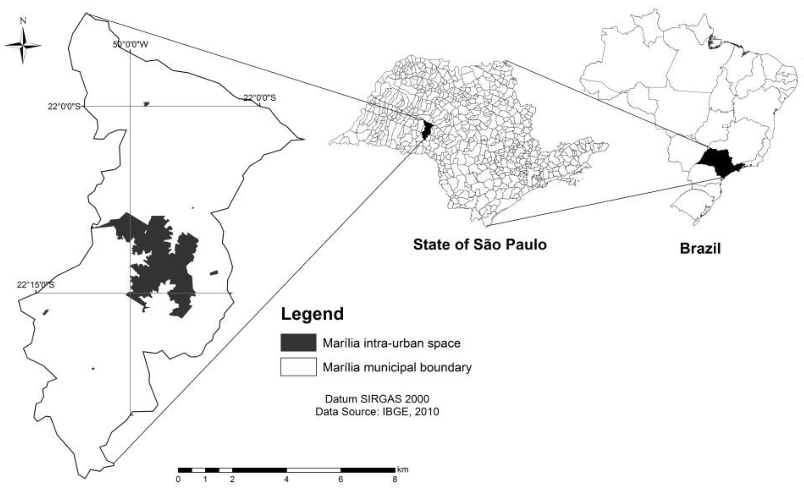
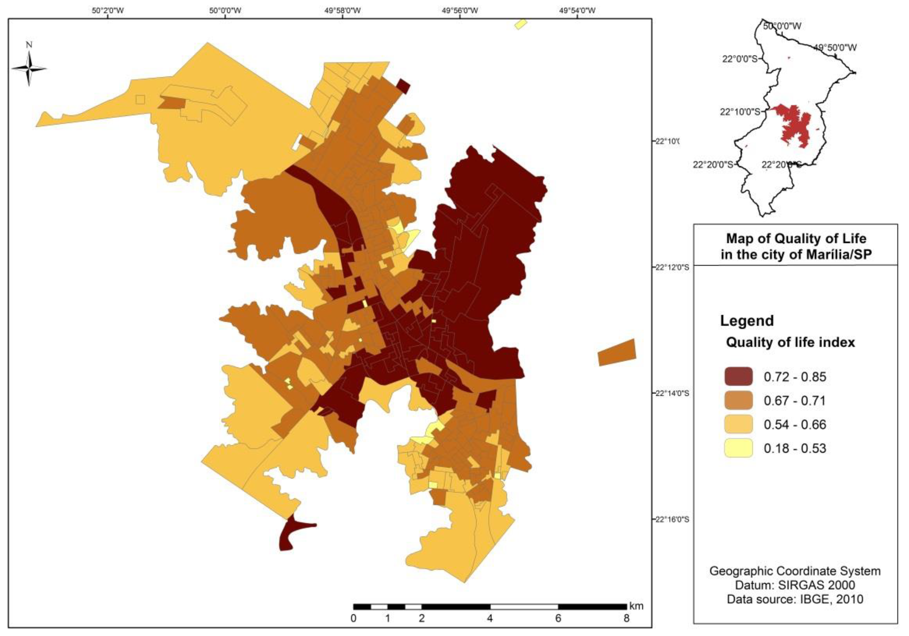
Marília is a municipality in the State of São Paulo (SP), Brazil, with an area of 1170 km2 [48]. It is a medium-sized city with 216,745 inhabitants [49]. Its intra-urban space has an “X” format (Figure 1).
The city has a subtropical climate [50], with an annual average temperature of 26.3 °C. The average minimum temperature is 13.5 °C, and the average maximum temperature is 26.2 °C. In summer, maximum temperatures above 39 °C can occur [51], which stimulates the construction of residential swimming pools and the search for building materials that prevent residences from absorbing heat. By Brazilian standards, the HDI (human development index) of Marília can be considered high (0.788) [48]. Although the HDI may have historically contributed to the municipality’s low crime rates, in 2005, Marília presented one of the highest crime rates in the region, and in the current period (2016–2017) it has shown a sharp increase in crime rates and violence [52].
Borsdorf et al. [11] points to the fact that GC can be observed in large and medium-sized cities throughout the continent of Latin America. When analyzing a medium-sized city in Brazil (Marília, São Paulo State), we observe that the existing features in GC are representative and consistent with those aspects presented in the literature review.
GC in Marília present characteristics similar to those described by Blakely and Snyder [24]. Thus, the concepts of GC for lifestyle and social prestige (golden ghettos) were adopted. The concept of lifestyle is characterized by the sharing of leisure structures among the residents. Those with a more prestigious social status, which value the privacy and safety of the residents more with a smaller number of common areas and larger residential lots, were classified as golden ghettos.
4. Methodology
The article proposes a methodology to (1) identify and map GCs using their morphological and physical features as well as the quality of life characteristics of their inhabitants. It is based on the analysis of the statistical correlation between the QOLI and LCC. The main idea is that by combining these features with social indices, which point to the characteristics of its inhabitants, it is possible to distinguish GC from non-gated areas. In addition, GC have some variable features, such as size and the presence of recreational facilities, (2) that allow us to classify them into two categories: lifestyle and golden ghettos, according to the typology proposed by Blakely and Snyder [24].
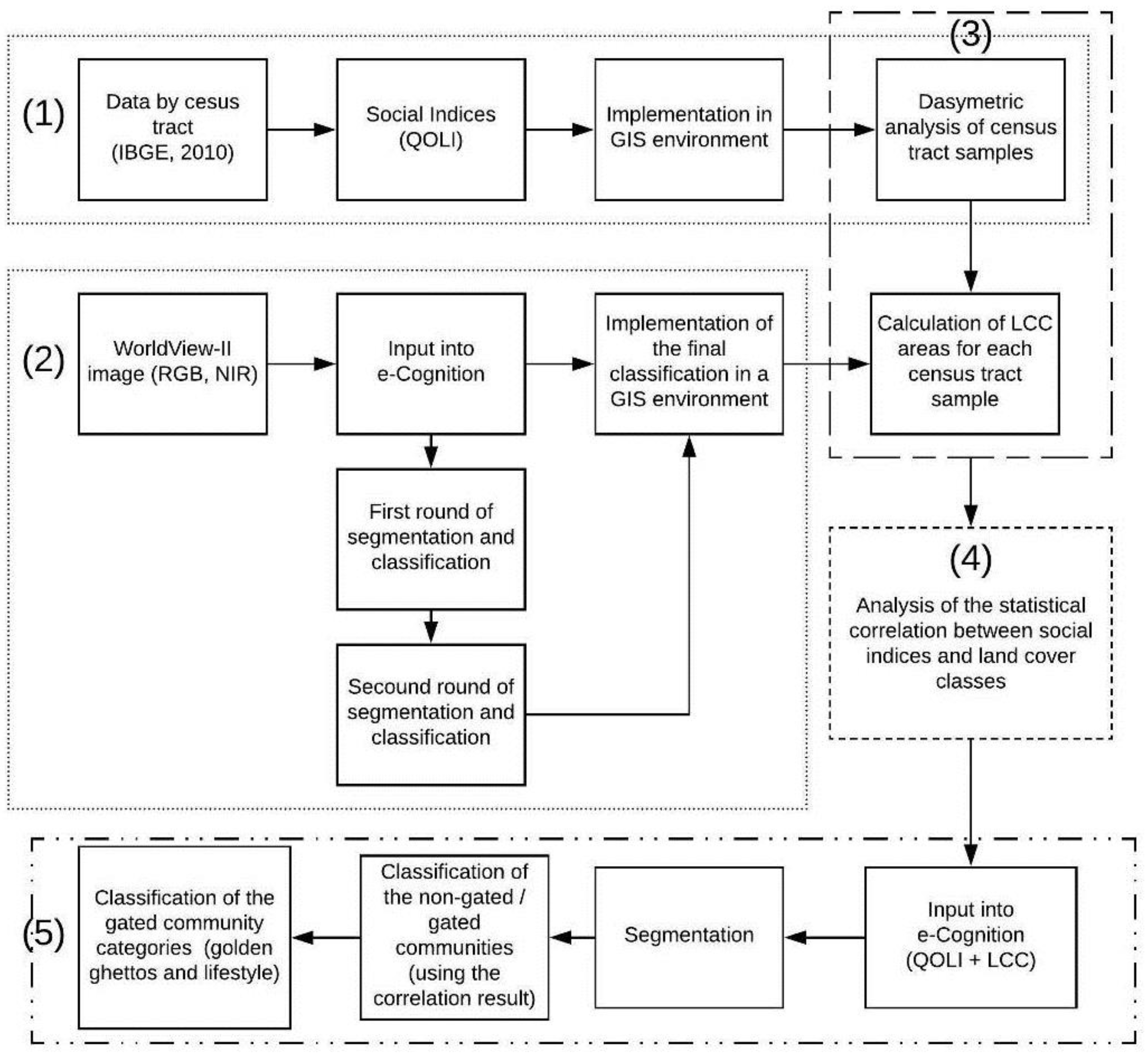
The procedures were as follows: (1) composition of the QOLI, (2) satellite image classification, (3) census tract dasymetric analysis to determine areas of LCC, (4) statistical correlation between the QOLI and the LCC areas, and (5) classification of GC based on the statistical correlation and LCC (Figure 2). The Pearson correlation coefficient (ρ) was used to measure the degree and direction of the correlation between the QOLI and the LCC maps of Marília. The correlation results were used to classify the areas of the city in non-gated communities (NGC)/GC and to categorize the types of GC into golden ghettos or lifestyle.
4.1. The Quality of Life Index (QOLI)
The QOLI summarizes the attributes of households and their inhabitants. It was created from the 2010 Brazilian Institute of Geography and Statistics [49] demographic census data. Data from the demographic census were used and grouped by census tracts (smallest collection unit). The QOLI Equation (1) comprises an arithmetic mean of the following indicators: household environmental quality (HEQI), education (EDUI), and economy (ECOI). Each census tract received a value according to formulation:
The variables used to construct the indicators, adapted after Jannuzzi [53], were as follows:
- Household environmental quality indicator (HEQI): burned garbage, buried garbage, collected garbage, network sewer system, rudimentary cesspit or ditch, and network water supply (normalized arithmetic mean of the variables);
- Educational indicator (EDUI): illiterate at 10 years of age or older and person responsible for household illiterate; and
- Economic indicator (ECOI): number of residents per bathroom and income of the head of household.
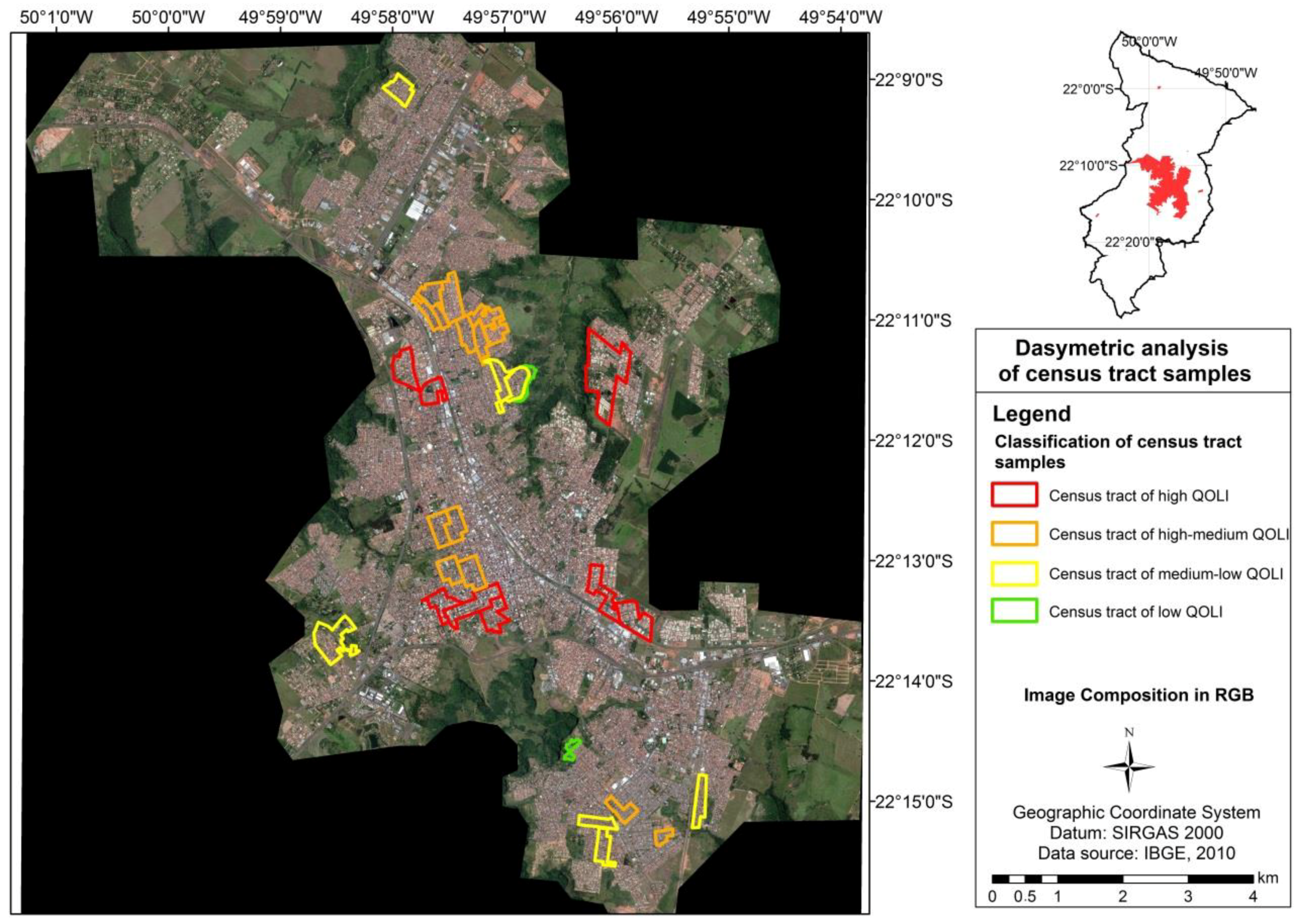
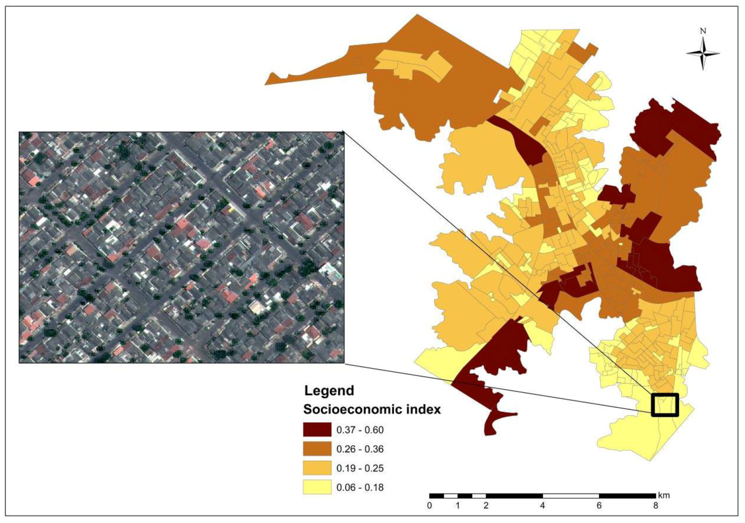
The QOLI was calculated by census tract and spatialized using a GIS. The Jenks (natural breaks) method was applied as the range method. It was considered a high-QOL census tract with values between 0.85 and 0.72, medium-high QOL with values between 0.71 and 0.67, medium-low QOL with values between 0.66 and 0.54, and low QOL with values between 0.54 and 0.18. This categorization was later used to select samples from census tracts for dasymetric procedures (Section 4.3).
4.2. Land Cover Classes (LCC)
GEOBIA was used to develop the land cover map of Marília’s urban land, following Benz et al. [40]. We used e-Cognition software by Trimble (http://www.ecognition.com/suite/ecognition-developer) and an 18/08/2010 WorldView-II satellite image with a spatial resolution of 2 m in the multispectral bands (blue, green, red, and near infrared) and 0.50 m in the panchromatic band as input.
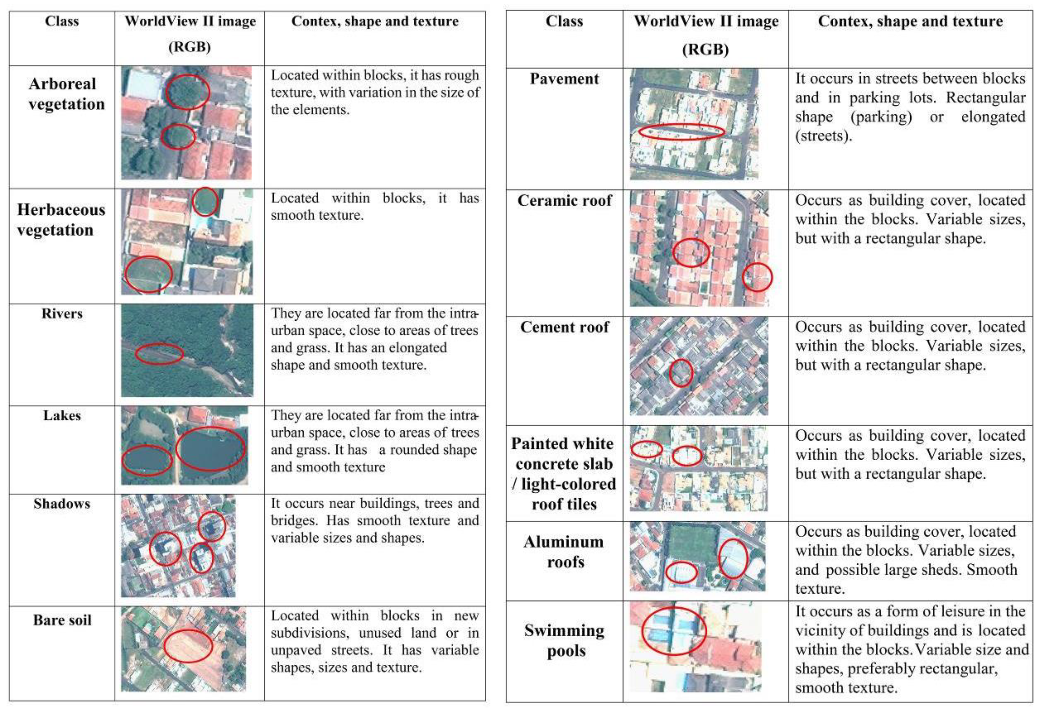
The interpretation key was elaborated from a visual interpretation and consists of an a priori systematization of the land cover classes (and their respective context, shape, and texture) that were classified semi-automatically using GEOBIA techniques. It considered 12 LCC: arboreal and shrub vegetation, herbaceous vegetation, rivers, lakes, shadows, bare soil, pavement, ceramic roofs, cement/asbestos roofs, painted concrete slab roofs/light-colored roof tiles, aluminum roofs, and swimming pools (Figure 3).
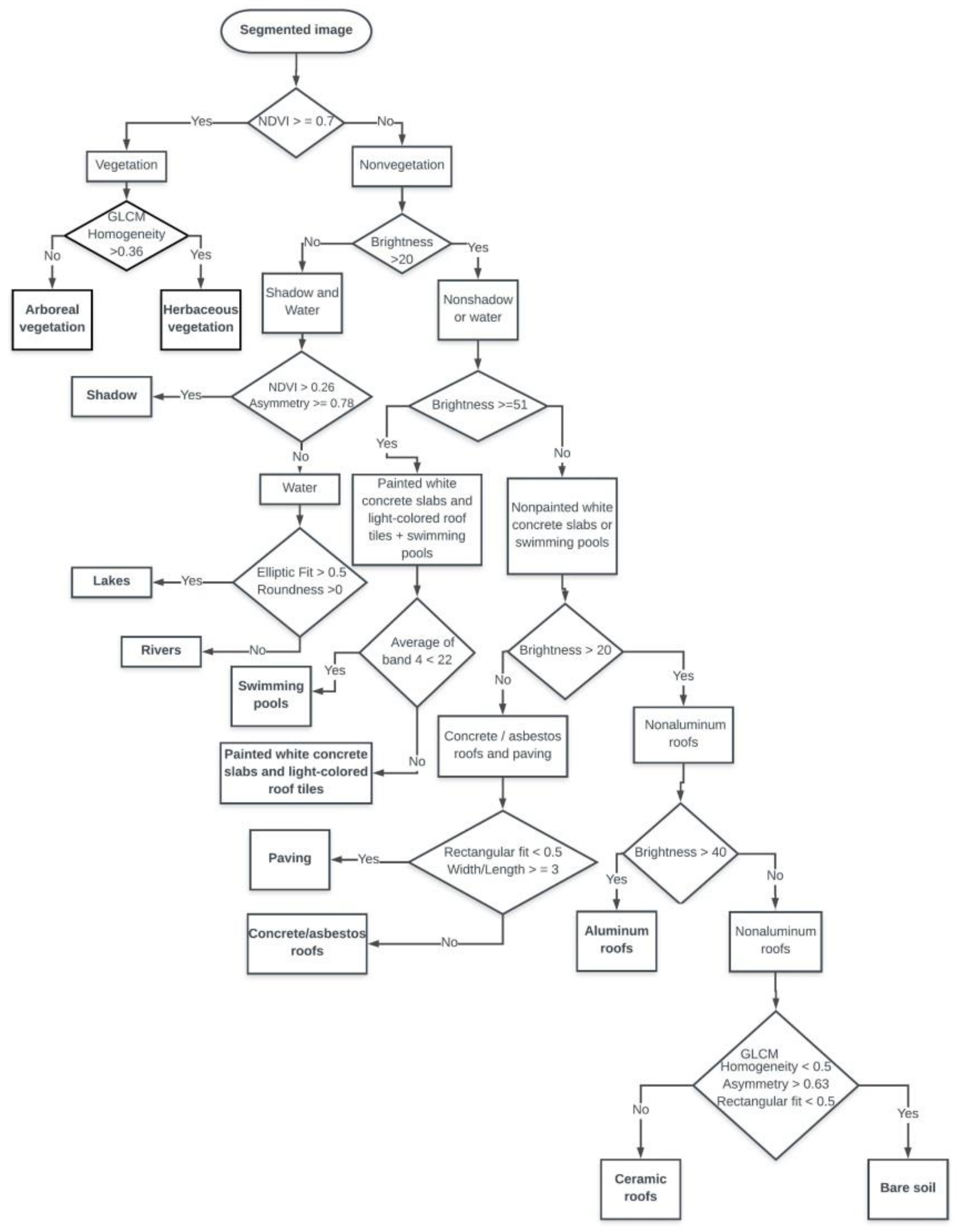
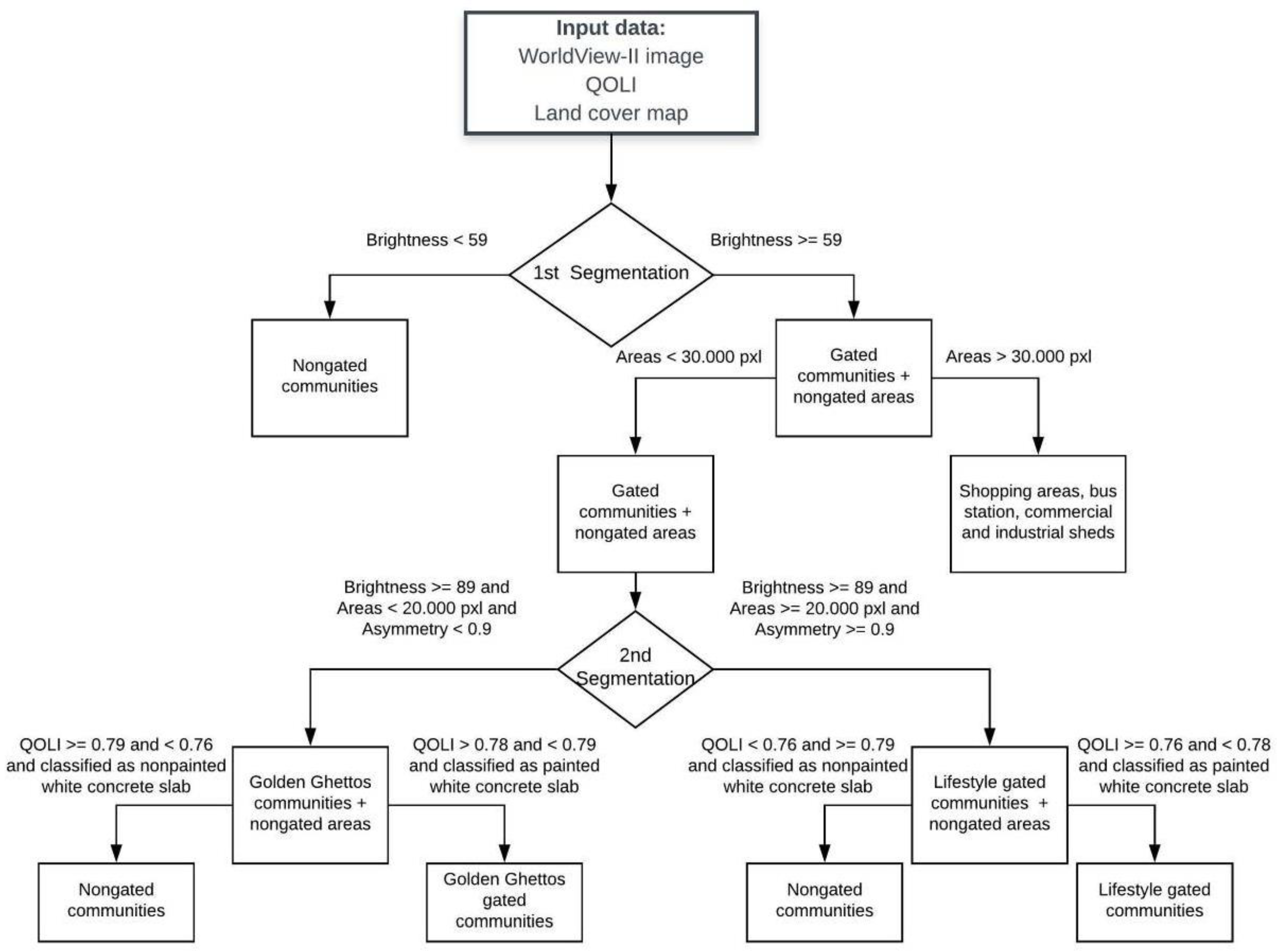
The WorldView-II image was segmented using multiresolution segmentation (Fractal Net Evolution Approach—FNEA algorithm) and the following parameters: scale 30, compactness 0.6, and shape 0.4. The decision tree, with the thresholds and parameters for the implementation of the classification rules in the e-Cognition software (Trimble: Munich; Germany), is summarized in Figure 4. The decision tree was developed using the criteria presented in Figure 3, and shows the selection and order of the inbuilt variables that were used in e-Cognition to classify the LCC. Table 1 presents the definition of each variable and the mathematical formulation.
To evaluate and validate the LCC classification, 440 random points of ground truth data were used to compose a confusion matrix (Table 2). The percentage of samples for each class was not pre-determined; rather, it followed the criterion of randomness. A kappa index was calculated from the confusion matrix results.
4.3. Census Tract Dasymetry
The census tract dasymetric analyses were used to determine areas of LCC inside the census tracts. The areas were used to determine the statistical correlation between the QOLI and the LCC areas (Table 3). By applying this procedure, it was also possible to determine the correlation between the coverage classes (Table 4). The Pearson correlation coefficient (ƿ) was used to measure the degree and direction of the correlation between the QOLI and the LCC and between each of the LCC. We used a Statistical Package for the Social Sciences (SPSS) from IBM (https://www.ibm.com/marketplace/spss-statistics) to calculate the correlation between the variables.
The basic principle of dasymetric mapping is to subdivide the original zones into smaller spatial units, increasing the internal consistency of the mapped variable [54,55]. Dasymetric procedures were applied to the census tracts to ensure the homogeneity of the LCC areas and to consider only built-up areas, eliminating the edge effect of the census tracts. A sample of 10% of the census tracts in each of the following classes was used: low, medium-low, medium-high, and high quality of life (total of 31 tracts), which can be observed in Figure 5. The areas were computed using GIS software.
4.4. Mapping the Gated Communities
The results of the statistical correlation between the LCC and the QOLI allowed the classification of the city areas between NGC and GC and allowed the categorization of GC into golden ghettos or lifestyle. The results (QOLI and LCC) were implemented along with the WorldView-II satellite image in the e-Cognition software and the information provided by the correlations between the QOLI and LCC and between each LCC were used to classify the city areas between gated and non-gated communities.
Control non-gated areas within the census tracts, whose population had high socioeconomic levels and high values of the QOLI, were adopted (Figure 6) in order to evaluate whether there was the occurrence of false positive classification errors.
The thresholds and classification parameters to classify GC based on the statistical correlation result contributed to eliminating the influence of the confounding factors of the image classification, such as areas with the same type of LCC as GC that were considered non-gated.
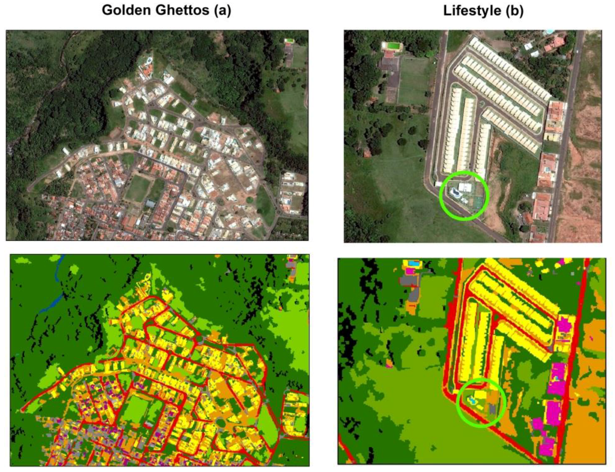
The subtle differences in the QOLI values allowed us to categorize GC between golden ghettos (with higher values of the QOLI and slightly larger areas) and lifestyle. Golden ghettos, adopted in this paper, are high-standard GC that can be easily identified by the size of the residences and urban plots (swimming pools and herbaceous and arboreal vegetation-landscaping) and their high socioeconomic, educational, environmental quality, and quality of life indices, as illustrated by the Garden Park (a) in Figure 7. Hence, these enclaves may be considered a type of “business card” that symbolizes the identity of their residents [56]. Lifestyle (b) GC were differentiated by the presence of a single collective leisure area and smaller lots (Figure 7). The indices show values close to those of the golden ghettos; however, they present a subtly minor value of the QOLI.
5. Results
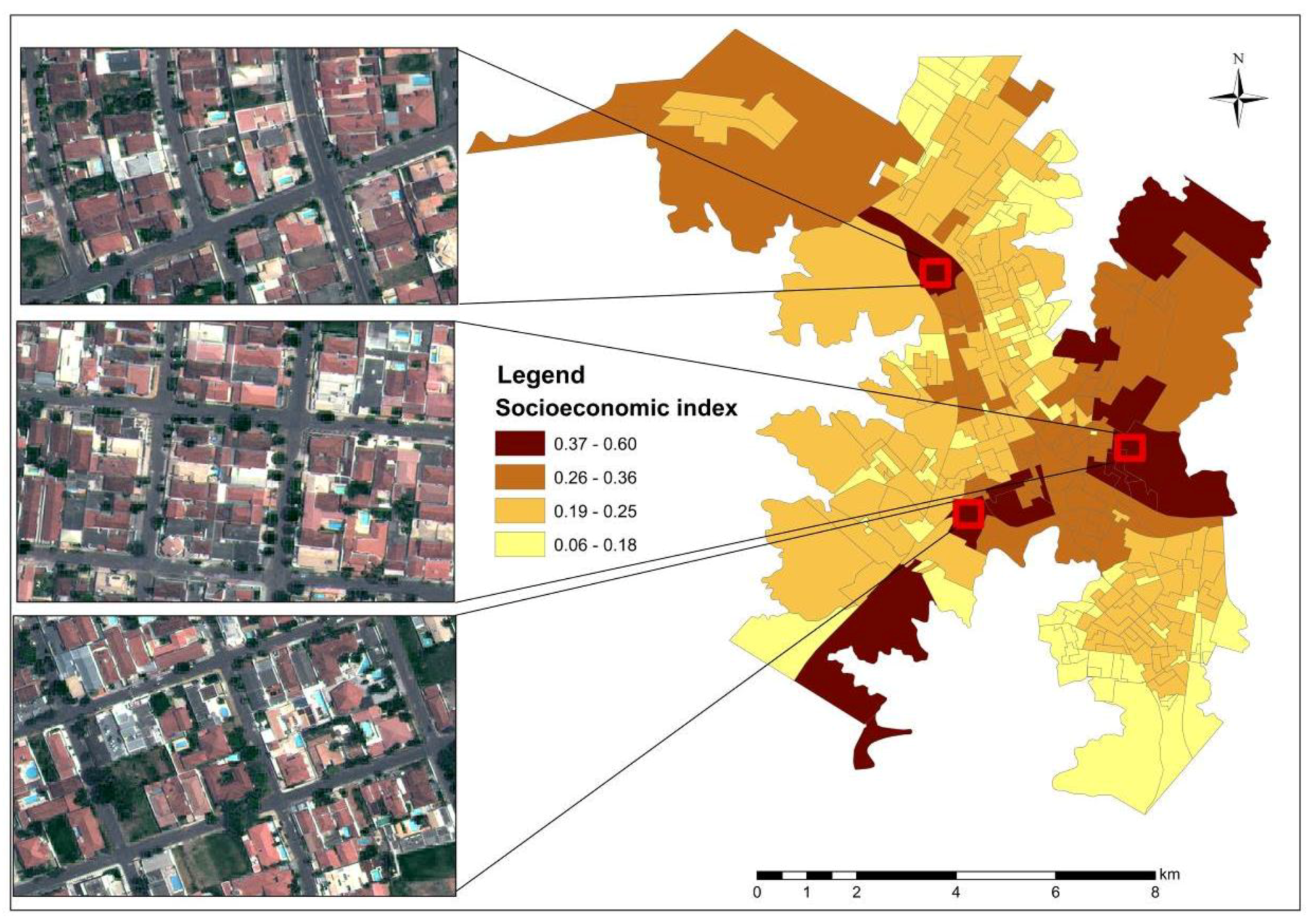
The QOLI map is shown in Figure 9. The LCC map evaluation is presented in the confusion matrix (Table 2). A kappa index of 0.86 was computed.
Analyzing Table 2, it can be concluded that the LCC that presented the least errors of omission (0%) and commission (0%) was the class “lakes”; however, only 1.1% random sample evaluated this class. Regarding the roofing classes, the class with the best observed agreement was the “painted white concrete slab/light-colored roof tiles”, with 2.66% error of omission and 8% error of commission. The class with the largest error was “ceramic roofs”, with a significant percentage that was confused with “bare soil” (32.85% error of omission and 30% error of commission).
The statistical correlation between the indices and the LCC data resulted in the correlation matrix (Table 3). The most significant correlations (between 0.437 and 0.934) are highlighted. The correlations between each LCC (between −0.494 and 0.723) were also analyzed, as shown in Table 4. The interpretations of the Pearson correlation coefficient follow the Mukaka [57] guidelines with small adaptations: values from 0.5 (in this article we consider values from 0.492) to 0.7 are considered moderate correlations, values from 0.7 to 0.9 are considered strong correlations, and values from 0.9 to 1.0 are considered very strong correlations.
5.1. Positive Correlation between Indices and Cover Classes
There was a positive correlation between the arboreal vegetation and the quality of life (0.429), environmental quality (0.753), and educational (0.537) indices, as shown in Table 3. The environmental quality index does not refer to the existence or lack of green coverage, but rather to the provision of basic sanitation services such as water supply, garbage collection by a cleaning service, and a sewer system.
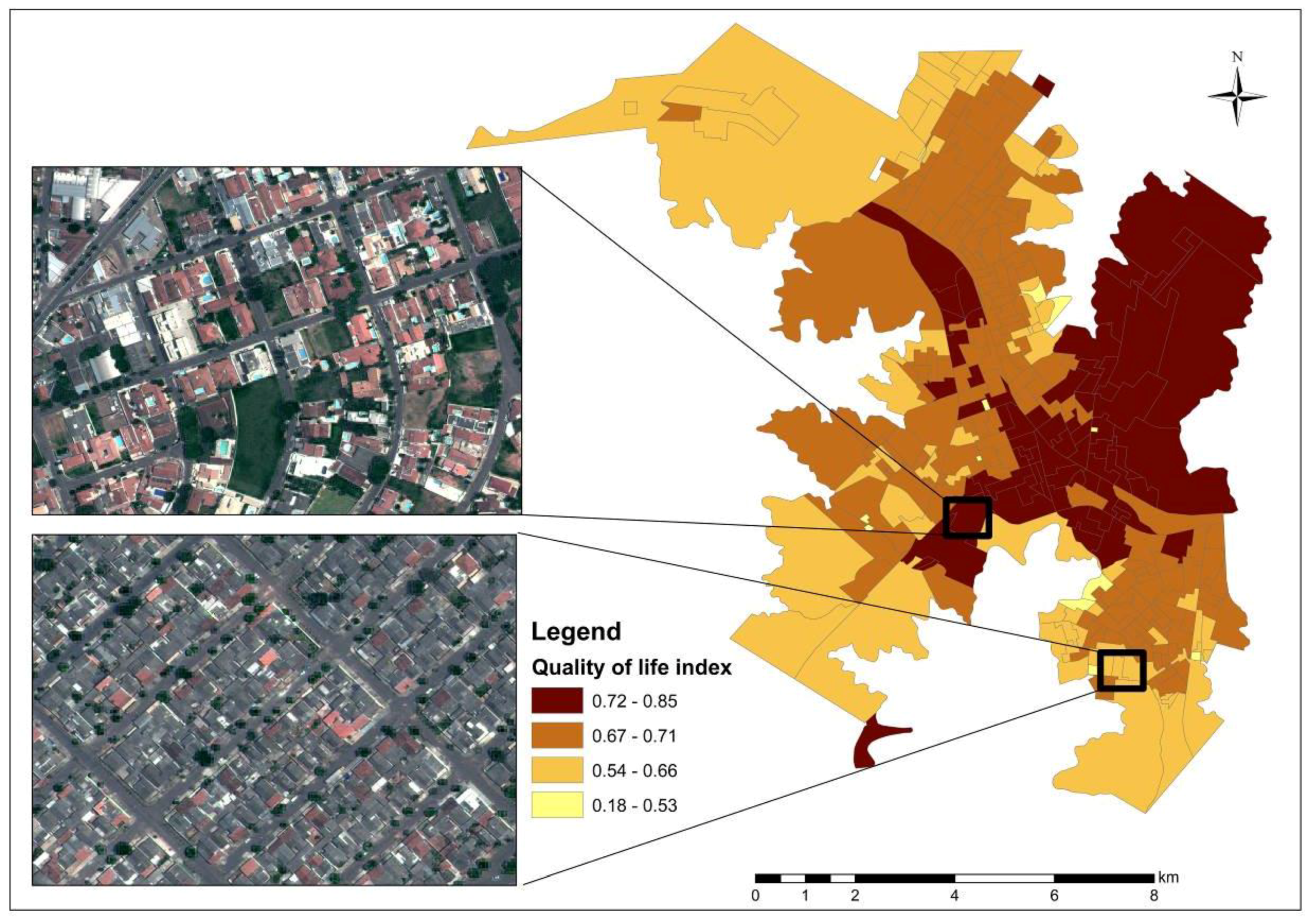
These data show that the tracts with the largest amount of arboreal vegetation, due to residential patterns with wooded lots or greater tree coverage for streets and avenues, tend to have high environmental quality, quality of life, educational, and socioeconomic indices, as shown in Figure 10.
Table 3 also reveals a relationship between the herbaceous plant coverage density and the resident population’s socioeconomic level indicators (0.437). An association among the quality of life, socioeconomic status, population income level, and vegetation coverage of the location where the population resides can be observed.
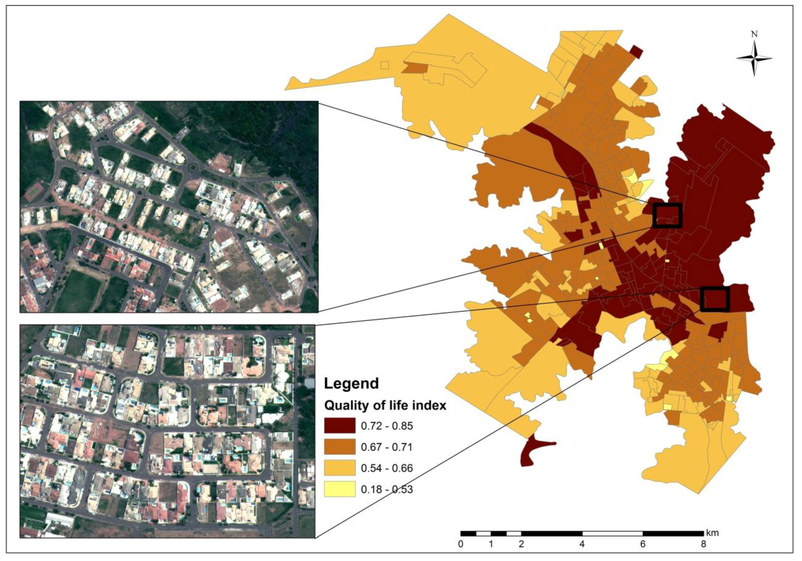
The positive correlation between “pools” and the QOLI (0.667), educational index (0.508), and socioeconomic index (0.934), as shown in Table 3, reveals high socioeconomic status residential patterns, which often occurs in GC in Marília. It is considered that these aspects characterize the process of self-segregation by the high social classes, which Caldeira [8] calls “fortified enclaves”; this is made explicit in the correlation, as shown in Figure 11.
Figure 11 also shows that the residences of these GC mostly have “painted white concrete roofs” or light-colored ceramic tiles. This reinforces the correlation between the QOLI and white painted concrete slab/light-colored roof tiles (0.715), the educational index (0.508), and the socioeconomic level index (0.775), as shown in Table 3.
Positive and significant correlations between “pavement” and the quality of life (0.485), environmental quality (0.727), and educational (0.460) indices show that the municipality’s sewer system and water supply are linked to the existence of asphalt pavement (sewer pipes and water run under the road’s pavement layer). Although basic sanitation services and road infrastructure have almost universal coverage in Marília, they are absent in areas of expansion and urban growth.
5.2. Intra-Urban Land Cover Class Correlations
Table 4 illustrates that the “herbaceous vegetation” and “arboreal vegetation” classes have a significant and positive correlation (0.474). There are indications that the two classes have a neighboring relationship; that is, they occur together, and when this relationship does not occur, it is because one exists at the expense of the other.
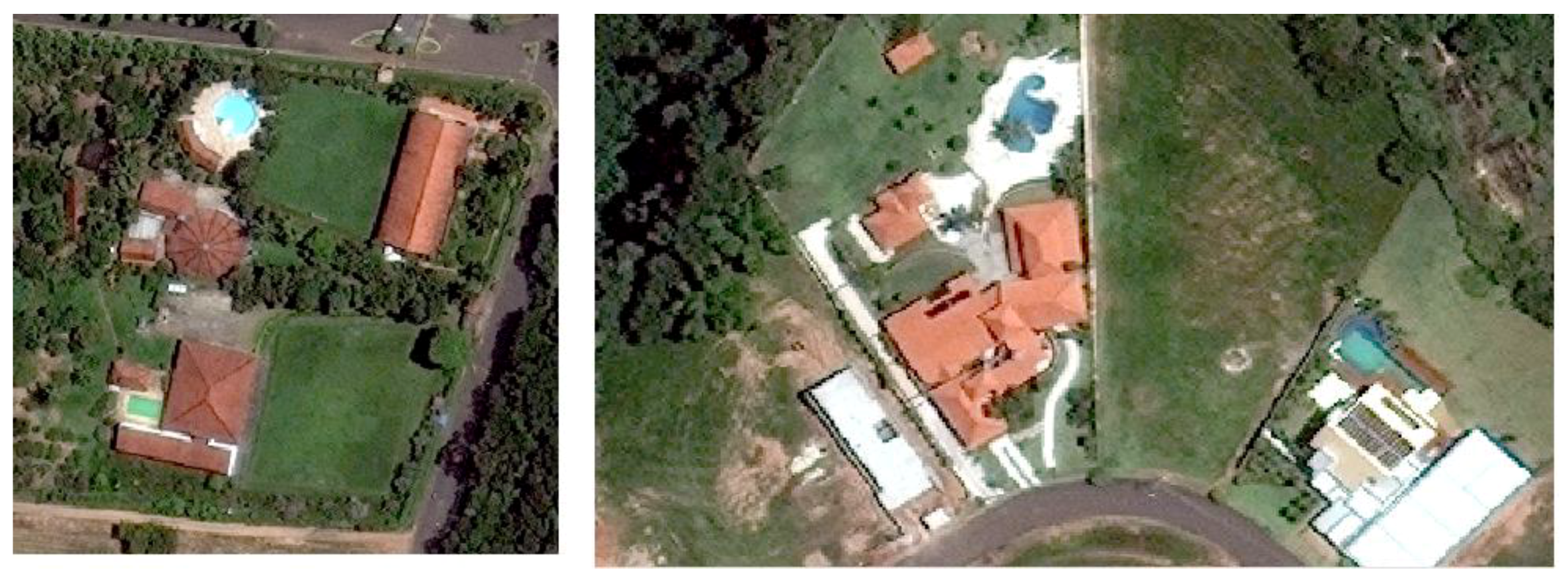
The positive correlations of “herbaceous vegetation” with the “pools” (0.555) and “lakes” (0.723) classes and between the “arboreal vegetation” and “lakes” (0.5) classes seem to be explained by architectural characteristics, given that these leisure facilities are often included in landscaping projects. The “herbaceous vegetation” and “pools” classes, as illustrated in Figure 12, are examples of this context, given that many gardens that have pools are adorned with lawns and herbaceous vegetation. The same process also seems to occur with the “arboreal vegetation” and “lakes” (0.5) classes. The two classes occur together because they are leisure facilities.
Table 4 also illustrates a positive and significant correlation between the “pools” and “white painted concrete slabs/light-colored roof tiles” (0.671) classes, which demonstrates that the high-income population resides in houses with painted concrete roof tiles or light-colored roof tiles and with pools, whereas the low-income population resides in housing without “pools” and with “cement/asbestos roof tiles” (−0.412).
The negative correlation of “arboreal vegetation” with the “ceramic roof tiles” (−0.529) and “cement/asbestos roof tiles” (−0.494) classes shows that denser tracts (more built-up areas) with a lower percentage of arboreal vegetation have these types of roofs. It can be observed from Figure 13 that ceramic roof tiles and asbestos cement roof tiles are often found to have a neighboring relationship and are used in Marília mostly in tracts where the socioeconomic index is medium-low.
5.3. Positive Correlation between the QOLI and the Presence of GC
The GC classification was analyzed statistically. A linear regression was adopted between the QOLI and the presence of GC in the census tract using a dummy variable. It was found that the census tracts that contain GC had a QOLI between 0.76 and 0.78. Hence, the urban areas were classified as NGC (<0.76 and >0.78) and GC (between 0.76 and 0.78).
To reduce the influence of confounding factors on the GC classification, the “white painted concrete slab/light-colored roof tiles” class was used to eliminate NGC within the census tract classified as high quality of life (Figure 8). As shown, in the control areas of high quality of life/high socioeconomic level index (Figure 6), independent of the census tract, the GC stand out for their white painted concrete slab/light-colored roof tiles and high brightness values (Figure 11).
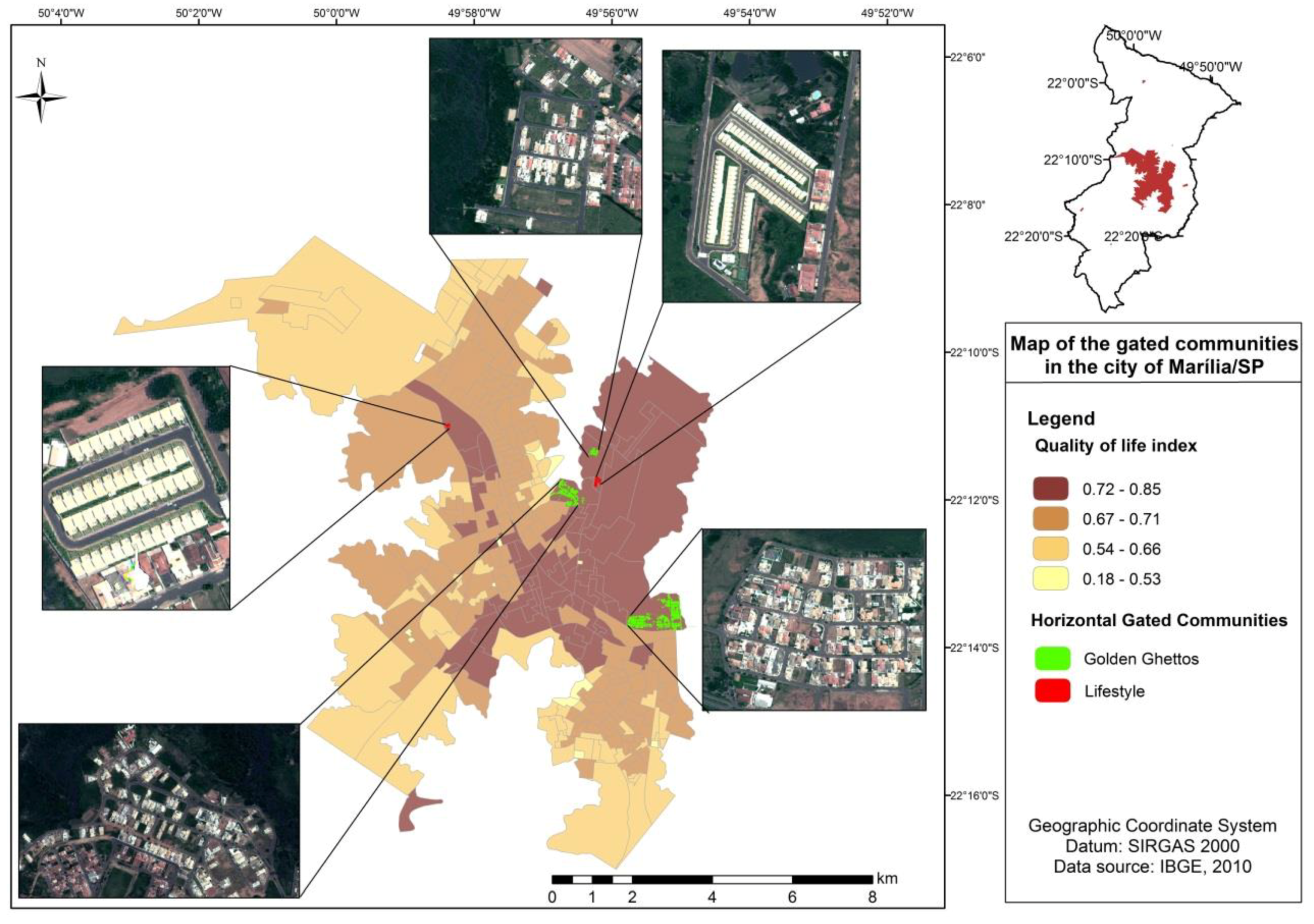
To classify the GC into lifestyle and golden ghettos, the QOLI was used. The golden ghettos were identified in the range between 0.772 and 0.787, and the lifestyle GC were between 0.763 and 0.767.
The GC map of Marília is presented in Figure 14. Six GC were classified out of the seven existing in the city. The results indicate that the combination of the QOLI and the LCC show an 83.33% success rate. The 16.67% misclassification occurred because the morphological features of one GC did not allow its classification. Considered the oldest in the city, the only unclassified GC had a similar morphology to the control areas (ceramic roof tiles, smaller lots, and fewer swimming pools). For this reason, it was mistakenly classified as non-gated.
It was observed that more recently built GC tend to use painted white concrete slabs or light-colored roof tiles. These form roofs that have a high reflectance of sunlight, which contribute to soften the internal temperature of the buildings but are more expensive. This can be explained by the high temperature averages of the region and by the high solar incidence throughout the whole year [58].
Painted white concrete slabs or light-colored roof tiles can be observed in high-standard NGC as well. However, with the mixture of ceramic roof tiles from neighboring houses (Figure 6), the roof areas are insignificant. False positive errors did not occur in the classification, because besides brightness, the area was used as a feature to classify the GC.
6. Discussion
The discussion will be presented in two directions: (1) the approach’s limitations and contributions and (2) the adaptability of the methodology for the mapping of GC in other cities.
First, is important to state that the methodology proposed in this article can contribute to updating official statistics on GC, as mentioned by Coy and Pöhler [4]. This method aims to quantify the GC and to determine their respective categories. The proposed methodology can also contribute to characterize the effects on urban segregation, as addressed by Le Goix [46]. The spatial characterization of GC tends to minimize the incompatibility between census tract boundaries and the boundaries of GC, as well as to discriminate the socioeconomic patterns of adjacent or discontinuous census tracts that are identified and characterized by the variation in land cover. It can be observed that for areas with a high socioeconomic level and QOLI, neighbors with GC or within the limits of the respective census tract have mostly ceramic roof tiles. Combining the QOLI with the LCC of painted concrete slab/light-colored roof tiles, it was possible to classify only the GC and to eliminate the confounding factors.
The positive correlation between the LCC and QOLI of the Marília population was also used to classify and categorize two main types of existing GC, as noted by Blakely and Snyder [24]: the elite, known as the golden ghettos, and the lifestyle type, with exclusive access to leisure facilities. A determinant factor for GC categorization (in golden ghettos and lifestyle GC) was size. Woo and Webster [44] previously commented on the relationship between size and private leisure infrastructure.
One of the limitations of the proposed methodology is that it was not possible to characterize or identify the third type of GC, known as security zones [24]. The fact that we could not identify security zone GC might be explained by the following: (1) urban violence is not necessarily expressed spatially; (2) there is a history of low crime rates in Marília; (3) walls and private security systems are common elements in all types of GC, sot was not possible to detect a unique security zone type feature in satellite images; and 4) satellite image resolution is poorly suited to identifying external walls/boundaries.
Another limitation is that the data used were able to classify only the horizontal GC (characterized by gated houses). Although, there are verticals GC (buildings) in Marília, the difficulty of representing the height of the buildings using the presented data did not allow their identification, and as a result, they were classified as non-gated. GC in the initial stage of implementation without built-up areas were also not possible to classify. In addition, they were considered as non-gated, since the characteristics of the residential building materials and built-up areas consitute the basis of the classification.
The land cover classification was based on GEOBIA. This has been shown to be an effective method for analyzing high-spatial resolution images and heterogeneous areas such as intra-urban spaces. The proposed method allowed the semi-automatic input of photointerpretation features such as geometry and texture into the classification rules. GEOBIA provided a means to overcome the limitations of traditional pixel-to-pixel classifications that commonly confuse urban elements due to internal spectral variation [39]. In addition, in comparison to the manual classifications by photointerpretation, it is a method that demands less time and reduces the subjectivity of the analyzer, since it strictly uses numerical data. The quality of the cartographic product was fundamental to the methodology. It is considered that the greater the accuracy of the mapping process, the better the result of the analysis should be.
It is also important to highlight that the QOLI is based on quantitative data, which express characteristics such as socioeconomic level, educational level, and access to basic infrastructure services (sewage system and water supply). A high quality of life, in this case, would not be associated with inhabiting GC but rather with having access to the minimum conditions of urban infrastructure. The census tracts with low quality of life values have other elements that characterize residential segregation, such as the presence of vertical and horizontal housing complexes.
It is considered that the results obtained for Marília (Brazil) can be easily reproducible and adaptable to other urban areas. This statement is based on the fact that, although there are local variations, some morphological and physical characteristics are common in most GC [43], such as recreational facilities (such as swimming pools and sports courts) [4,8,23,24,28,43,46], civil infrastructures (private roads) [43,47], and the presence of green areas and lakes [4,8,28,43]. Additionally, the internal social homogeneity of the condominiums but external heterogeneity is recurrent in relation to other social groups in other cities [59].
7. Final Considerations
The proposed methodology allowed the spatial characterization of gated communities in the city of Marília, with an accuracy of 83.33%. The positive correlation between the quality of life index and the land cover allowed us to classify and map the golden ghetto and lifestyle categories of gated communities as well as to quantify them. These two categories presented similar quality of life index values, but their morphological characteristics allowed an unequivocal distinction. The confounding factors of the satellite image classification were reduced using land cover map classes: white painted concrete slab roofs/light-colored roof tiles, pavement, swimming pools, and herbaceous vegetation as a landscape feature.
It is considered that this methodology can be adapted to classify the gated communities of other cities using the local characteristics. This methodology can be improved in future research by exploring the density of objects such as swimming pools. The use of LiDAR (Light Detection and Ranging) data may overcome the problem of classifying vertical gated communities. This laser scanning system allows the development of accurate three-dimensional maps and improves the accuracy of the land cover map classification.
The results obtained illustrate that this type of urban segregation, or self-segregation, follows classic principles established in the literature: the gated communities tend to be located in areas with a good urban infrastructure, with access to water and sewer systems through the general network and easy access to the road network; moreover, their residents have a medium to high income and high educational levels (there are no head of households or people over 10 years of age who are illiterate).
Author Contributions
A.P.d.Q. contributed to the conception of the study, as well as the central idea, and helped with the manuscript review; A.S.d.A. performed the data analyses and wrote the manuscript.
Funding
This research was funded by the National Council of Research and Technology (CNPq) of Brazil; grant number 166602/2013-2.
Conflicts of Interest
The authors declare no conflict of interest.
References
- Schuermans, N. Enclave urbanism as telescopic urbanism? Encounters of middle class whites in Cape Town. Cities 2016, 59, 183–192. [Google Scholar] [CrossRef]
- Roitman, S. Who Segregates Whom? The Analysis of a Gated Community in Mendoza, Argentina. Hous. Stud. 2005, 20, 303–321. [Google Scholar] [CrossRef]
- Power, M. Angola 2025: The Future of the “World’s Richest Poor Country” as Seen through a Chinese Rear-View Mirror. Antipode 2012, 44, 993–1014. [Google Scholar] [CrossRef]
- Coy, M.; Pöhler, M. Gated communities in Latin American megacities: Case studies in Brazil and Argentina. Environ. Plan. B Plan. Des. 2002, 29, 355–370. [Google Scholar] [CrossRef]
- Thuillier, G. Gated Communities in the Metropolitan Area of Buenos Aires, Argentina: A challenge for Town Planning. Hous. Stud. 2005, 20, 255–271. [Google Scholar] [CrossRef]
- Hillier, J.; Mcmanus, P. Pull up the drawbridge: Fortress mentality in the suburbs. In Metropolis Now: Planning and the Urban in Contemporary Australia; Gibson, K., Watson, S., Eds.; Pluto Press: Sydney, Australia, 1994; pp. 91–107. ISBN 1864030143. [Google Scholar]
- Gonzalez, D. Bahamians resent the loss of beaches to luxury. New York Times, 29 February 2000; Volume 29, A4. [Google Scholar]
- Caldeira, T.P. City of Walls: Crime, Segregation, and Citizenship in São Paulo; University of California Press: London, UK, 2000; 487p, ISBN 0-520-22142-7. [Google Scholar]
- Carvalho, M.; George, R.V.; Anthony, K.H. Residential satisfaction in condominios exclusivos (gate-guarded neighborhoods) in Brazil. Environ. Behav. 1997, 29, 734–768. [Google Scholar] [CrossRef]
- Grant, J. Planning responses to gated communities in Canada. Hous. Stud. 2005, 20, 273–285. [Google Scholar] [CrossRef]
- Borsdorf, A.; Hidalgo, R.; Sanchez, R. A new model of urban development in Latin America: The gated communities and fenced cities in the metropolitan areas of Santiago de Chile and Valparaíso. Cities 2007, 24, 365–378. [Google Scholar] [CrossRef]
- Pow, C.P. Gated Communities in China: Class, Privilege and the Moral Politics of the Good Life; Routledge: New York, NY, USA, 2009; ISBN 0-415-47810-3. [Google Scholar]
- Zhao, P. Reprint of “An ‘unceasing war’ on land development on the urban fringe of Beijing: A case study of gated informal housing communities”. Cities 2017, 60 Pt B, 139–146. [Google Scholar] [CrossRef]
- Zhao, W.; Zou, Y. Un-gating the gated community: The spatial restructuring of a resettlement neighborhood in Nanjing. Cities 2017, 60, 78–87. [Google Scholar] [CrossRef]
- Wu, F.; Webber, K. The rise of “foreign gated communities” in Beijing: Between economic globalization and local institutions. Cities 2004, 21, 203–213. [Google Scholar] [CrossRef]
- Blandy, S. Gated communities in England: Historical perspectives and current developments. GeoJournal 2006, 66, 15–26. [Google Scholar] [CrossRef]
- Carrasquillo, C.A.S. Gated communities and city marketing: Recent trends in Guaynabo, Puerto Rico. Cities 2011, 28, 444–451. [Google Scholar] [CrossRef]
- Raposo, R. Gated communities, commodification and aestheticization: The case of the Lisbon metropolitan area. GeoJournal 2006, 66, 43–56. [Google Scholar] [CrossRef]
- Blinnikov, M.; Shanin, A.; Soboley, N.; Volkova, L. Gated communities of the Moscow green belt: Newly segregated landscapes and the suburban Russian environment. GeoJournal 2006, 66, 65–81. [Google Scholar] [CrossRef]
- Glasze, G.; Alkhayyal, A. Gated housing estates in the Arab world: Case studies in Lebanon and Riyadh, Saudi Arabia. Environ. Plan. B Plan. Des. 2002, 29, 321–336. [Google Scholar] [CrossRef]
- Jürgens, U.; Landmann, K. Gated communities in South Africa. In Private Cities: Global and Local Perspectives; Glasze, G., Webster, C.J., Frantz, K., Eds.; Routledge, Taylor and Francis: London, UK, 2006; pp. 109–126. ISBN 0-415-34170-1. [Google Scholar]
- Elhadary, Y.; Ali, S. A New Trend in Urban Housing: Gated Communities in Khartoum, Sudan. Am. J. Sociol. Res. 2017, 7, 45–55. [Google Scholar] [CrossRef]
- Atkinson, R.; Blandy, S. Introduction: International perspectives on the new enclavism and the rise of gated communities. Hous. Stud. 2005, 20, 177–186. [Google Scholar] [CrossRef]
- Blakely, E.J.; Snyder, M.G. Fortress America: Gated Communities in the United States; Brookings Institution Press & Lincoln Institute of Land Policy: Washington, DC, USA; Cambridge, MA, USA, 1997; 208p, ISBN 0815791070. [Google Scholar]
- Lang, R.E.; Danielsen, K.A. Gated communities in America: Walling out the world? Hous. Policy Debate 1997, 8, 867–899. [Google Scholar] [CrossRef]
- Paulin, D. Rising crime rate has city dwellers seeking safety in apartments and gated communities. Globe Mail 1997, 23, A12. [Google Scholar]
- Lemanski, C. A new apartheid? The spatial implications of fear of crime in Cape Town, South Africa. Environ. Urban. 2004, 16, 101–112. [Google Scholar] [CrossRef] [Green Version]
- Irazábal, C. Localizing Urban Design Traditions: Gated and Edge Cities in Curitiba. J. Urban Des. 2006, 11, 73–96. [Google Scholar] [CrossRef]
- Coy, M. Gated communities and urban fragmentation in Latin America: The Brazilian experience. GeoJournal 2006, 66, 121–132. [Google Scholar] [CrossRef]
- Olajide, S.E.; Lizam, M. Gated Communities and Property Fencing: A Response to Residential Neighbourhood Crime. Br. J. Educ. Soc. Behav. Sci. 2016, 13, 1–9. [Google Scholar] [CrossRef]
- Azocar, G.; Romero, H.; Sanhueza, R.; Vega, C.; Aguayo, M.; Munoz, M.D. Urbanization patterns and their impacts on social restructuring of urban space in Chilean mid-cities: The case of Los Angeles, Central Chile. Land Use Policy 2007, 24, 199–211. [Google Scholar] [CrossRef]
- Estoque, R.C.; Murayama, Y. Intensity and spatial pattern of urban land changes in the megacities of Southeast Asia. Land Use Policy 2015, 48, 213–222. [Google Scholar] [CrossRef]
- Filion, P.; Hammond, K. Neighborhood land use and performance: The evolution of neighborhood morphology over the 20th century. Environ. Plan. B 2003, 30, 271–296. [Google Scholar] [CrossRef]
- Puertas, O.L.; Henríquez, C.; Meza, F.J. Assessing spatial dynamics of urban growths using land use model. Application in Santiago metropolitan area, 2010-2045. Land Use Policy 2014, 38, 415–425. [Google Scholar] [CrossRef]
- Taubënbock, H.; Roth, A.; Dech, S. Linking structural urban characteristics derived from high resolution satellite data to population distribution. In Urban and Regional Data Management, UDMS Annual 2007; Taylor & Francis: London, UK, 2008; pp. 35–45. ISBN 978-0-415-44059-2. [Google Scholar]
- Hay, G.J.; Castilla, G. Geographic Object-Based Image Analysis (GEOBIA): A new name for a new discipline. In Object-Based Image Analysis; Springer: Berlin/Heidelberg, Germany, 2008; pp. 75–89. [Google Scholar]
- Hofmann, P.; Strobl, J.; Blaschke, T.; Kux, H.J. Detecting informal settlements from QuickBird data in Rio de Janeiro using an object-based approach. In Object Based Image Analysis; Blaschke, T., Lang, S., Hay, G.J., Eds.; Springer: Berlin/Heidelberg, Germany, 2008; pp. 531–554. [Google Scholar]
- Walker, J.S.; Blaschke, T. Object-based land-cover classification for the Phoenix metropolitan area: Optimization vs. transportability. Int. J. Remote Sens. 2008, 29, 2021–2040. [Google Scholar] [CrossRef]
- Brum-Bastos, V.S.; Ribeiro, B.M.G.; Pinho, C.M.D.; Korting, T.S.; Fonseca, L.M.G. Improvement evaluation on ceramic roof extraction using WorldView-2 imagery and geographical data mining approach. Int. Arch. Photogram. Remote Sens. Spat. Inf. Sci. 2016, XLI-B7, 883–889. [Google Scholar] [CrossRef]
- Benz, U.C.; Hofmann, P.; Willhauck, G.; Lingenfelder, I.; Heynen, M. Multi-resolution, object-oriented fuzzy analysis of remote sensing data for GIS-ready information. ISPRS J. Photogram. Remote Sens. 2004, 58, 239–258. [Google Scholar] [CrossRef] [Green Version]
- Low, S.M. The edge and the center: Gated communities and the discourse of urban fear. Am. Anthropol. 2001, 103, 45–58. [Google Scholar] [CrossRef]
- Wilson-Doenges, G. An exploration of sense of community and fear of crime in gated communities. Environ. Behav. 2000, 32, 597–611. [Google Scholar] [CrossRef]
- Grant, J.; Mittelsteadt, L. Types of Gated Communities. Environ. Plan. B Urban Anal. City Sci. 2004, 31, 913–930. [Google Scholar] [CrossRef] [Green Version]
- Woo, Y.; Webster, C. Co-evolution of gated communities and local public goods. Urban Stud. 2014, 51, 2539–2554. [Google Scholar] [CrossRef]
- Sabatini, F.; Salcedo, R. Gated communities and the poor in Santiago, Chile: Functional and symbolic integration in a context of aggressive capitalist colonization of lower-class areas. Hous. Policy Debate 2007, 18, 577–606. [Google Scholar] [CrossRef]
- Le Goix, R. Gated Communities: Sprawl and Social Segregation in Southern California. Hous. Stud. 2005, 20, 323–343. [Google Scholar] [CrossRef] [Green Version]
- Webster, C.; Lai, L. Property Rights, Planning and Markets: Managing Spontaneous Cities; Edgar Elgar Publishing Limited: Massachussets, MA, USA, 2003; 310p, ISBN 1-84064-904-6. [Google Scholar]
- Instituto Brasileiro De Geografia E Estatística—IBGE. Cidades. Available online: http://cidades.ibge.gov.br/brasil/sp/marilia/panorama (accessed on 20 June 2018).
- Instituto Brasileiro De Geografia e Estatística—IBGE. Censo Demográfico de 2010; Centro de Documentação e Disseminação de Informações: Rio de Janeiro, Brazil, 2011.
- Kottek, M.; Grieser, J.; Beck, C.; Rudolf, B.; Rubel, F. World map of the Köppen-Geiger climate classification updated. Meteorol. Z. 2006, 15, 259–263. [Google Scholar] [CrossRef]
- CPTEC/INPE. Análise Climática de Marília/SP. Available online: https://pt.climate-data.org (accessed on 22 September 2017).
- Secretaria De Segurança Pública Do Estado De São Paulo—SSP 160/01 Relatório de Estatísticas de Ocorrências Criminais por Região. Available online: http://www.ssp.sp.gov.br/Estatistica (accessed on 22 September 2017).
- Jannuzzi, P.M. Indicadores Sociais no Brasil—Conceitos, Fontes de Dados e Aplicações Para: Formulações e Avaliações de Políticas Públicas e Elaboração de Estudos Socioeconômicos; Editora Alínea: Campinas, Brazil, 2009; 141p, ISBN 8586491950. [Google Scholar]
- Eicher, C.L.; Brewer, C.A. Dasymetric Mapping and Areal Interpolation: Implementation and Evaluation. Cartogr. Geogr. Inf. Sci. 2001, 28, 125–138. [Google Scholar] [CrossRef]
- Petrov, A. One Hundred Years of Dasymetric Mapping: Back to the Origin. Cartogr. J. 2012, 49, 256–264. [Google Scholar] [CrossRef]
- Abrahamson, M. Urban Enclaves: Identity and Place in America; Series Contemporary Social Issues; St. Martin’s Press: New York, NY, USA, 1996; 152p, ISBN 0312114990. [Google Scholar]
- Mukaka, M.M. A guide to appropriate use of Correlation coefficient in medical research. Malawi Med. J. 2012, 23, 69–71. [Google Scholar]
- Santamouris, M.; Synnefa, A.; Karlessi, T. Using advanced cool materials in the urban built environment to mitigate heat islands and improve thermal comfort conditions. Sol. Energy 2011, 85, 3085–3102. [Google Scholar] [CrossRef]
- Le Goix, R.; Webster, C.J. Gated communities. Geogr. Compass 2008, 2, 1189–1214. [Google Scholar] [CrossRef] [Green Version]
Figure 1.
Location map of Marília’s intra-urban space.

Figure 2.
Methodological flow chart.

Figure 3.
Interpretation key.

Figure 4.
Classification rule decision tree in the e-Cognition software.

Figure 5.
Dasymetric analysis of the census tract samples.

Figure 6.
Map of the location and morphology of the control areas.

Figure 7.
Garden Park (golden ghetto (a)) and Collibri gated communities (GC) (lifestyle (b)).

Figure 8.
Classification rule decision tree to classify GC into categories.

Figure 9.
Quality of life index map.

Figure 10.
Illustration of the relationship among the arboreal vegetation, residential pattern, and QOLI.
Figure 10.
Illustration of the relationship among the arboreal vegetation, residential pattern, and QOLI.

Figure 11.
Illustration of the relationship among painted concrete slabs/light-colored roof tiles, pools, and the QOLI.
Figure 11.
Illustration of the relationship among painted concrete slabs/light-colored roof tiles, pools, and the QOLI.

Figure 12.
Illustration of the correlation between leisure areas with pools and herbaceous and arboreal vegetation. WorldView II Image—Garden Park Condominium.
Figure 12.
Illustration of the correlation between leisure areas with pools and herbaceous and arboreal vegetation. WorldView II Image—Garden Park Condominium.

Figure 13.
Illustration of the negative correlation among ceramic and cement roofs, arboreal vegetation, and socioeconomic level.
Figure 13.
Illustration of the negative correlation among ceramic and cement roofs, arboreal vegetation, and socioeconomic level.

Figure 14.
GC map categorized into lifestyle and golden ghettos.


Table 1.
Quantifiable attributes and inbuilt variables in e-Cognition.
| Type of Attribute | Quantifiable Attribute | Mathematical Formulation | Description |
|---|---|---|---|
| Spectral | Normalized Difference Vegetation Index (NDVI) | NDVI = mean () | The NDVI is the value between −1.0 and +1.0 |
| Brightness | B = | B is the mean brightness of an object and is the sum of all the mean brightness values in the visible bands divided by the corresponding number of visible bands | |
| Average of band 4 (NIR) | Band 4 = mean (NIR) | The average of band 4 is the mean value of an object in band 4 (NIR) | |
| Measures how symmetrical the objects are: | |||
| Geometric | Asymmetry | 1 − | = is the minimum eigenvalue = is the maximum eigenvalue |
| Roundness | , for 0 ≤ x − C ≥ 1 − C | Describes how well (x) an image object fits into a circle (C); values are between 1 (perfect fit) and 0 (no fit) | |
| Elliptic Fit | , for 0 ≤ x − E ≥ 1 − E | Describes how well (x) an image object fits into an ellipse (E); values are between 1 (perfect fit) and 0 (no fit) | |
| Rectangular Fit | , for 0 ≤ x – T ≥ 1 − T | Describes how well (x) an image object fits into a rectangle (T); values are between 1 (perfect fit) and 0 (no fit) | |
| Shape Length/Width | Length of the image object Width of the image object | ||
| Area | A = n° pixels | Area is a measure of the number of pixels inside each object | |
| Textural | GLCM Homogeneity | H = | The measure of sensitivity to the presence of near diagonal elements in a GLCM (gray level co-occurrence matrix) is the number of gray levels and is the entry i,j in the GLCM |
Table 2.
Satellite image classification confusion matrix and kappa index.
| # | Herbaceous Vegetation | Ceramic Roofs | Arboreal Vegetation | Shadows | Bare Soil | Pavement | Aluminum Roofs | Painted White Concrete Slab/Light-Colored Roof Tiles | Cement Roofs | Pools | Lakes | Classes | |
|---|---|---|---|---|---|---|---|---|---|---|---|---|---|
| Herbaceous vegetation | 26 | 0 | 7 | 0 | 0 | 0 | 0 | 0 | 0 | 0 | 0 | 33 (7.5%) | |
| Ceramic roofs | 0 | 47 | 1 | 0 | 15 | 0 | 0 | 3 | 4 | 0 | 0 | 70 (15.9%) | |
| Arboreal vegetation | 0 | 0 | 35 | 0 | 0 | 0 | 0 | 0 | 1 | 0 | 0 | 36 (8.2%) | |
| Shadows | 0 | 0 | 1 | 1 | 0 | 0 | 0 | 0 | 0 | 0 | 0 | 2 (0.5%) | |
| Bare soil | 0 | 0 | 0 | 0 | 56 | 0 | 0 | 1 | 0 | 0 | 0 | 57 (13.0%) | |
| Pavement | 0 | 0 | 0 | 0 | 0 | 51 | 0 | 0 | 6 | 0 | 0 | 57 (13.0%) | |
| Aluminum roofs | 0 | 0 | 0 | 0 | 4 | 1 | 33 | 1 | 1 | 0 | 0 | 40 (9.1%) | |
| Painted white concrete slab/light-colored roof tiles | 0 | 0 | 0 | 1 | 1 | 0 | 0 | 73 | 0 | 0 | 0 | 75 (17.0%) | |
| Cement roofs | 0 | 0 | 0 | 0 | 1 | 5 | 0 | 0 | 48 | 0 | 0 | 54 (12.3%) | |
| Pools | 0 | 0 | 0 | 0 | 0 | 0 | 0 | 1 | 0 | 10 | 0 | 11 (2.5%) | |
| Lakes | 0 | 0 | 0 | 0 | 0 | 0 | 0 | 0 | 0 | 0 | 5 | 5 (1.1%) | |
| Field truth | 26 (5.9%) | 47 (10.7%) | 44 (10.0%) | 2 (0.5%) | 77 (17.5%) | 57 (13.0%) | 33 (7.5%) | 79 (18.0%) | 60 (13.6%) | 10 (2.3%) | 5 (1.1%) | 440 | |
| Observed Agreement: 87.5% | |||||||||||||
| Chance Agreement: 12.39% | |||||||||||||
| Kappa Coefficient: 85.73% | |||||||||||||
Table 3.
Correlation matrix between the research indices/social indicators and land cover classes.
| Areas of the Land Cover Classes | Quality of Life Index (QOLI) | Household Environmental Quality Indicator (HEQI) | Educational indicator (EDUI) | Economic indicator (ECOI) |
|---|---|---|---|---|
| Arboreal Vegetation Area (HERBVA) | 0.281 | 0.042 | 0.140 | 0.437 |
| Arboreal Vegetation Area (ARBVA) Bare Soil Area | 0.492 | 0.753 | 0.537 | −0.104 |
| (BARSA) | −0.045 | 0.036 | −0.094 | −0.036 |
| Shade Area (SHADEA) | 0.229 | 0.092 | 0.196 | 0.276 |
| Ceramic Roof Area (CERARA) Painted Concrete Slab Area | 0.193 | 0.370 | 0.266 | −0.055 |
| (PCSA) | 0.715 | 0.299 | 0.657 | 0.775 |
| Cement Roof Area (CRA) | −0.170 | 0.270 | 0.103 | −0.299 |
| Aluminum Roof Area (ARA) Pavement Area | 0.291 | 0.243 | 0.348 | 0.186 |
| (PAVA) | 0.485 | 0.727 | 0.460 | 0.163 |
| Pool Area (POOLA) | 0.677 | 0.094 | 0.508 | 0.934 |
| Lake Area (LAKEA) | 0.099 | −0.059 | 0.077 | 0.186 |
Table 4.
Land cover class correlation matrix.
| Areas of the Land Cover Classes | HERBVA | ARBVA | BARSA | SHADEA | CERARA | PCSA | CRA | ARA | PAVA | POOLA | LAKEA |
|---|---|---|---|---|---|---|---|---|---|---|---|
| HERBVA | 1.000 | 0.474 | −0.177 | 0.247 | −0.333 | 0.254 | −0.469 | −0.380 | −0.305 | 0.555 | 0.723 |
| ARBVA | 0.474 | 1.000 | −0.190 | 0.153 | −0.592 | −0.177 | −0.494 | −0.281 | −0.740 | 0.181 | 0.500 |
| BARSA | −0.177 | −0.190 | 1.000 | −0.030 | −0.170 | −0.170 | −0.472 | −0.158 | −0.253 | −0.139 | −0.163 |
| SHADEA | 0.247 | 0.153 | −0.030 | 1.000 | −0.306 | 0.231 | −0.162 | 0.146 | −0.118 | 0.258 | 0.407 |
| CERARA | −0.333 | −0.592 | −0.170 | −0.306 | 1.000 | 0.122 | 0.106 | −0.056 | −0.118 | 0.258 | 0.407 |
| PCSA | 0.254 | −0.177 | −0.117 | 0.231 | 0.122 | 1.000 | −0.372 | 0.140 | 0.200 | 0.671 | 0.212 |
| CRA | −0.469 | −0.494 | −0.472 | −0.162 | 0.106 | −0.372 | 1.000 | 0.319 | 0.519 | −0.412 | −0.471 |
| ARA | −0.038 | −0.281 | −0.158 | 0.146 | −0.059 | 0.140 | 0.319 | 1.000 | 0.123 | 0.048 | −0.130 |
| PAVA | −0.305 | −0.740 | −0.253 | −0.118 | 0.409 | 0.200 | 0.519 | 0.123 | 1.000 | 0.004 | −0.381 |
| POOLA | 0.555 | 0.181 | −0.139 | 0.258 | −0.171 | 0.671 | −0.412 | 0.048 | 0.004 | 1.000 | 0.273 |
| LAKEA | 0.723 | 0.500 | −0.163 | 0.407 | 0.226 | 0.212 | −0.471 | −0.130 | −0.381 | 0.273 | 1.000 |
© 2018 by the authors. Licensee MDPI, Basel, Switzerland. This article is an open access article distributed under the terms and conditions of the Creative Commons Attribution (CC BY) license (http://creativecommons.org/licenses/by/4.0/).
Share and Cite
MDPI and ACS Style
Silva de Araujo, A.; Pereira de Queiroz, A. Spatial Characterization and Mapping of Gated Communities. ISPRS Int. J. Geo-Inf. 2018, 7, 248. https://doi.org/10.3390/ijgi7070248
AMA Style
Silva de Araujo A, Pereira de Queiroz A. Spatial Characterization and Mapping of Gated Communities. ISPRS International Journal of Geo-Information. 2018; 7(7):248. https://doi.org/10.3390/ijgi7070248
Chicago/Turabian StyleSilva de Araujo, Agnes, and Alfredo Pereira de Queiroz. 2018. "Spatial Characterization and Mapping of Gated Communities" ISPRS International Journal of Geo-Information 7, no. 7: 248. https://doi.org/10.3390/ijgi7070248
Note that from the first issue of 2016, this journal uses article numbers instead of page numbers. See further details here.