1. Introduction
The Mediterranean basin has been a perennial arena of conflict throughout history, owing to its strategic location. This has resulted in a legacy of defensive architectural structures. Such a dynamic has naturally attracted the attention of numerous researchers. For instance, Ref. [
1] delve into the interactions between North Africa and Southern Europe dating back to prehistoric times. Their research highlights the multifaceted economic, environmental, and sociopolitical relationships between these regions, shedding light on the role of warfare in driving solutions for achieving new economic and military supremacy.
To fully understand these medieval fortresses, it is essential to first examine the conditions surrounding their emergence and the historical circumstances in which they were built. Beyond the dominance of their defensive architecture, which dictated their creation, other sociopolitical, economic, and religious factors were equally crucial in determining their location and construction. Sheila Blonda [
2] demonstrates how the historical events surrounding the construction of medieval fortresses on the Mediterranean coast are indicative of their intimate involvement with sociopolitical, cultural, and technological changes during that era. Additionally, other environmental factors detailed in Ronnie Ellenblum’s work [
3] facilitated the nomadization wave in the early 10th century, impacting Asia Minor, the eastern coast of the Mediterranean, the Middle East, and North Africa, a phenomenon she terms “Medieval Warm”. These changes led to the decline of several civilizations and major cultural centers at that time.
Drawing upon a wealth of historical and archaeological evidence, Ronnie Ellenblum [
3] explores the impact of sociocultural, political, and environmental changes on the establishment and construction of medieval fortifications. The current era has seen increased interconnectivity in various domains, including culture, commerce, the military, and politics [
4]. Among these significant events, the rise in the slave trade and commercial routes played a crucial role in the initial construction of medieval fortifications, significantly influencing their strategic placement [
5,
6]. This era was marked by intense exchanges and interactions across several domains (cultural, commercial, military, and political). The authors [
5,
6,
7,
8] underscore the impact of the Islamic slave trade and commercial routes, considering pivotal events in the construction of medieval fortresses at the onset of Muslim conquests and the prudent selection of their locations.
Within our research context, the study [
9] delves into events related to maritime navigation and the transport of goods between the Spanish Mediterranean coast and the Algerian coastal cities. These active commercial exchanges greatly influenced the dynamics of fortress establishment.
The scope of the current study centers on the fortifications constructed during the medieval era along the Mediterranean coastline, specifically during the Muslim conquest of the Western territories of the Islamic world spanning from the 8th to the 17th centuries AD, with primary emphasis on regions covering Algeria and Spain. The selection of these fortresses is anchored in a historical chronology that spans diverse geographical contexts. Originally conceived as symbols of power and authority, these fortresses were meticulously crafted with defense and strategic considerations at the forefront.
While prior studies [
10,
11] have discussed medieval fortresses along the north Mediterranean coast of Algeria and Southeastern Spain, most have adopted a descriptive rather than analytical approach. We contend that quantifying the strategic value of these fortresses is imperative for gaining a comprehensive understanding of the conditions that underpinned their establishment and the influence of their chosen locations on the configuration of their defensive systems. This approach represents a novel methodology for assessing archaeological sites endowed with defensive significance, a dimension unexplored in previous research.
In the initial phase of our research, dedicated to identifying various architectural typologies of these fortresses, a plethora of sources provided insights into the general characteristics of fortified structures in the Western territories conquered by Muslims [
10,
11,
12]. These scholars have conducted intriguing archaeological excavations of early medieval fortresses, enabling us to reconstruct the morphology of the initial Muslim fortresses and understand their architectural attributes and spatial arrangement. Additionally, ref. [
13] investigates the selection of fortress locations in the late antique Pessinus region of Turkey, delineating different phases of occupation supported by archaeological excavation results from over 15 sites spanning both ancient and medieval periods, while this study tends toward descriptiveness, it provides initial insights into the multifaceted roles of fortresses beyond defense, highlighting their significance as visual and physical landmarks within a perceived landscape.
Several previous studies have explored the relationship between natural landscapes and defensive architecture [
14,
15,
16,
17,
18,
19]. Notably, Andrew Martindale and Kisha Supernant [
16] propose a method for assessing the defense level of fortified sites, highlighting that the strategic value of such sites can be gauged through the quantification of their defensiveness. They introduce the defensiveness index (DI), a unique value derived from four distinctive measures: visibility, elevation, site accessibility, and surface area. Employing empirical research and cartographic data, they demonstrate the feasibility of evaluating a site’s defense by considering its location and the defensive architectural characteristics related to biomechanics. The defensiveness index value spans from zero defense (DI = 0) to maximum defense (DI = 4).
In another complementary study by [
17], a GIS-based method is employed to assess the defensibility of village sites, underscoring the significance of defensive considerations and the impact of warfare on the selection of certain prehistoric village locations in the Mid-Fraser region.
The physical attributes of the landscape, such as visibility and elevation, have emerged as crucial factors influencing human settlement choices during times of conflict. R. Kyle Bocinsky [
18] utilized a GIS to develop a spatial defensibility index, derived from the visibility and elevation of fortified sites. Furthermore, he introduces a comprehensive method applicable to archaeological sites of strategic importance.
The significance of a fortified site’s visibility depends on its position and altitude relative to potential enemy attack routes. In this study [
20], a method was applied to investigate intervisibility and visual communication among a series of fortifications along the Line of Torres Vedras in Lisbon, Portugal, that date back to the 19th century and were utilized during the Napoleonic Wars. The pivotal role of visibility in facilitating effective communication and protection against adversaries was demonstrated.
Numerous other authors [
19,
21,
22,
23,
24,
25,
26,
27,
28] have contributed to the field of GIS analysis for assessing the visibility and defensibility of archaeological sites. They have incorporated various parameters, including visual coverage, topographical features, line of sight, communication routes, and architectural and defensive attributes of fortified archaeological sites.
R. Kyle Bocinsky [
18] explored decision-making processes in assessing landscape defensibility and introduced two crucial parameters: visibility and elevation. He calculated indices for these factors across a raster landscape (DEM) using GIS analysis to determine their impact on defensive considerations. In our research, we adopt a similar approach, albeit in the distinct context of the Mediterranean coast, focusing on Algeria and Spain.
While our research contexts differ, the approaches developed for evaluating defensive archaeological sites converge on common factors, such as:
Location and physical landscape characteristics—visibility, elevation, line of sight, and terrain morphology.
Spatial configuration, encompassing architectural and defensive elements, surface area, and defense structures.
In another work of St. Popovic et al. [
29], a digital representation and spatial analysis method is employed across four medieval distinct regions: the Eastern European Alps, Austria’s border regions, the historical territories of Albania and Bulgaria, and the historic southern region of Armenia. This method, abbreviated as DPP (Digitizing Patterns of Power), involves integrating natural, sociopolitical, historical, and technological elements using a GIS as in our study. We draw inspiration from this approach and share a similar perspective in our research. We examined the methodological approaches outlined in this edition, particularly the digital approach in historical research. This publication is designed as a guidebook and model for best practices in historical geography and digital humanities. This enables us to understand how to analyze the locations described in medieval written sources and archival documents, examine the interactions between human development and the natural environment, and subsequently utilize digital tools to analyze the studied patterns.
Our research significantly contributes to understanding medieval fortresses along the Mediterranean coast by integrating historical, archaeological, and spatial data to analyze their defensive strategies. This novel methodological approach allows us to gain deeper insights into the factors influencing the design and construction of these fortifications.
The remainder of this article is structured as follows: The first section introduces our work and summarizes prior relevant research. The second provides background information on the research, introducing the process of assessing defended archaeological sites.
Section 3 outlines our proposed approach and research objectives. In
Section 4, we present our study corpus within its historical and geographical context.
Section 5 is dedicated to experimental results and discussion, where we present the defensibility index derived from visibility and elevation parameters, applying it to each case study and comparing their effectiveness in various implementation sites. Finally, in
Section 5, we present the conclusion of this paper.
3. Objectives and Methodology
The objective of this research is to examine the defensive characteristics of Mediterranean coastal fortresses, specifically focusing on how visibility and elevation influenced their design and evolution. We aim to understand the factors that contributed to the development of these fortifications and how their defensive systems adapted to changing strategic needs.
Our methodology predominantly relies on a combination of complementary tools, encompassing graphic and historical documents, such as archives, in conjunction with GIS-based analysis programs. Additionally, we introduce a calculation approach for assessing visual prominence, utilizing a line simplification technique borrowed from cartography and modeled using the Skyline tool within the 3D Analyst-ArcGIS extension, applied to a Digital Elevation Model (DEM) with a 30 m resolution. Here, we outline the methodology developed in our research:
3.1. Identification of Line-of-Sight Points
Referring to historical data and using archival maps, we identified our study examples and located the observation points. These points include areas covered from the fortresses to determine their extent, along with other visible points from these fortresses, known as “viewshed points”, such as vantage points used for potential attacks, and the surrounding fortresses.
The studied fortresses are situated in mountainous locations or at the highest points of cities, contributing to their preservation without significant alterations since their construction. These various aspects allowed us to overlay archival maps onto current maps for georeference at each point while considering on-site observations.
By obtaining the geodetic coordinates for each point and determining the fortress wall heights, we can utilize parameters from ArcGIS military tools to quantify visibility indices and intervisibility between two or more points, particularly during line-of-sight (LOS) analysis.
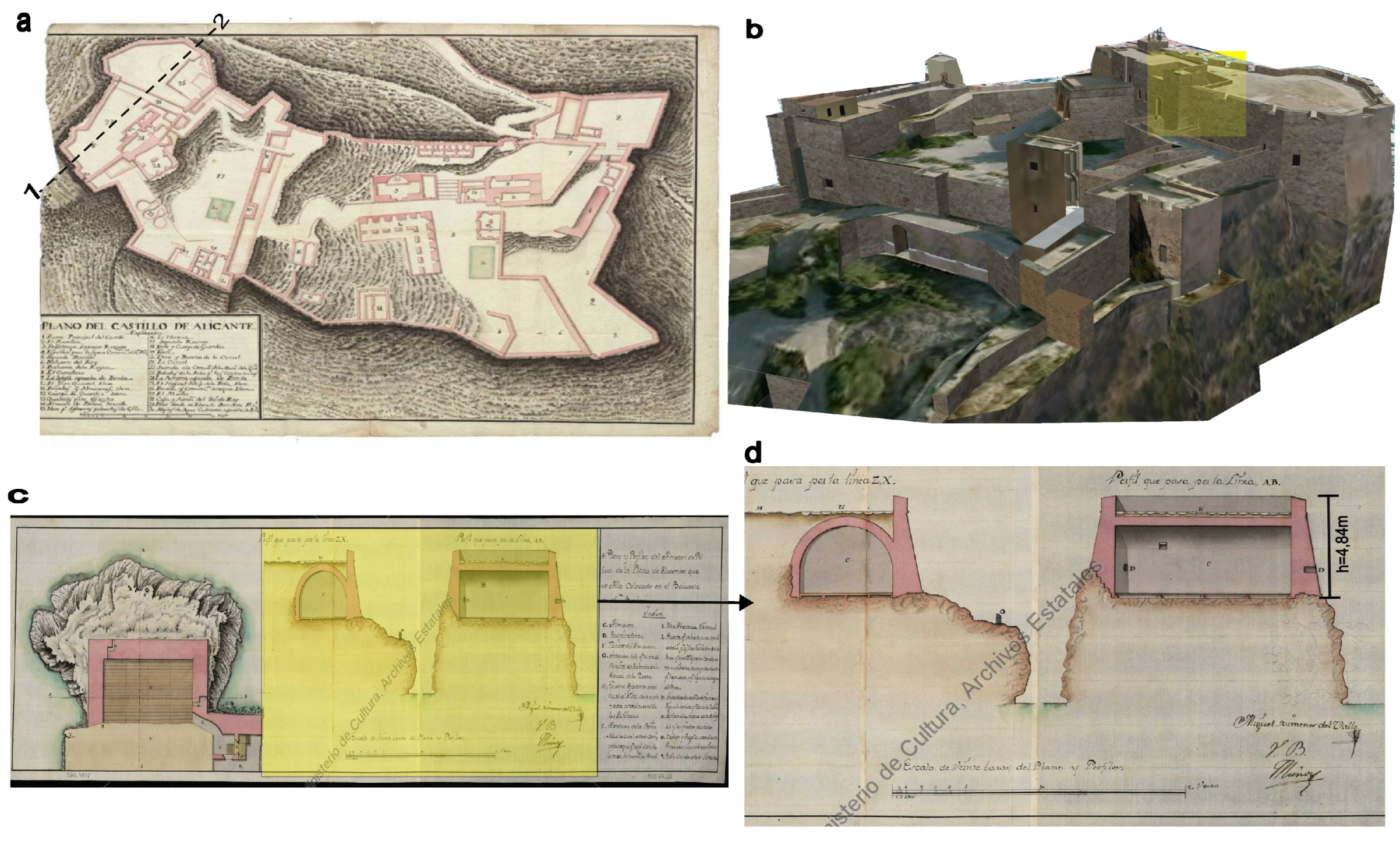
Figure 1 illustrates the height of the Santa Barbara Fortress wall based on archival documents. (a) shows the plan of the Santa Alicante fortress with a horizontal section “1-2”. (b) shows the 3D elevation of the current state of preservation of the fortress and specific wall. (c) and (d) present the profile of section “1-2”. Notably, on the map scale, every 1 cm represents one vara (an ancient measurement unit used in Spain, equivalent to 0.93 m). The actual height of the wall measures 4.84 m.
This method enabled us to calculate the height of fortress walls from an archive. This height is included in the calculation of visibility from the studied fortress.
3.2. GIS-Based Analysis for Defensibility Assessment
To evaluate the defensibility of each landscape encompassing our case studies, we performed visibility and elevation analyses, yielding their respective defense indices. The outcomes were obtained through ArcGIS 10.6 software. Before conducting our analysis, we undertook several crucial steps that paved the way for our final results:
Acquiring a Digital Elevation Model (DEM) of the study landscape: This process involved pinpointing each of our case studies and all defensive structures and elements serving visual or physical communication purposes for each fortress.
Georeferencing and updating of archive maps: For accurate identification of observation points and target heights from each fortress, we relied on historical records, including archives, which represent the defense strategy adopted at the time. Additionally, the position of the fortress in relation to the sea, and sometimes communication links (intervisibility) within a single defense system, were documented in these archives. We georeferenced and updated this information using ArcGIS. Furthermore, we identified distances between the fortresses and attack points, which are pivotal in assessing visibility, particularly in our context, where the control of maritime attacks is a constant concern.
Conducting visibility and intervisibility analysis. Visibility is regarded as the decisive factor in defensibility along the Mediterranean coast. By leveraging visibility analysis tools in ArcGIS, we first generated a global vision raster from an observation point, incorporating the necessary attributes for each fortress. We also defined OFFESTA(m) values, which represent vertical distances in meters that account for the fortress’s height added to the site’s altitude.
3.3. Performing Line-of-Sight Analysis
Several of the fortresses under study are part of a broader network of military fortifications. Therefore, it is essential to assess the intervisibility within this system, deducing its defensive efficacy and reconstructing the defense strategy employed by medieval builders. The graphical representation of the results is presented in the form of a linear line-of-sight analysis to determine intervisibility between the observation point and the target of observation applied to a digital modal terrain (DEM).
We have employed the visibility parameter within military tools for ArcGIS, enabling linear line-of-sight analysis. This allows the determination of whether the target is visible from one or more locations. Elevation data sets have been added to the map, where the green line of sight designates visible areas from one or more observation points based on a given distance and field of view, while the red indicates areas that are not visible.
3.4. Assessing Defensiveness
As previously mentioned, and in accordance with the work of Martindale and Supernant [
16], we assessed the effectiveness of the defense of medieval fortresses along the Mediterranean coast. The calculation of visibility and elevation indices was executed using the ArcGIS 3D spatial analyst extension, utilizing the visibility and slope analysis tools for each case study on their respective raster landscapes (DEM).
4. Case Studies
In our study, we carefully selected samples representing various typologies along a chronological axis and within their respective geographical contexts. Given the impossibility of examining all fortresses, we strategically chose a model from each typology.
Several criteria determined the selection of our study sites, notably historical significance and the availability of archival data, the state of preservation of our samples, and architectural and construction typology.
It is worth noting that there are challenges and gaps in selecting several representative examples from each era, especially between the 8th and 13th centuries. This is either due to the absence of a chronology of fortresses despite their mention in historical writings, or their complete disappearance, making it impossible for us to evaluate them in our case.
Another factor is a lack of archaeological data. Therefore, through our selection, we aimed to select a representative model from each period that exhibited similar spatiotemporal and architectural characteristics.
Another selection factor is the good state of preservation of each sample and the archaeological excavations conducted through stratigraphic studies to restore their construction morphology. This helped us compare them with their current state.
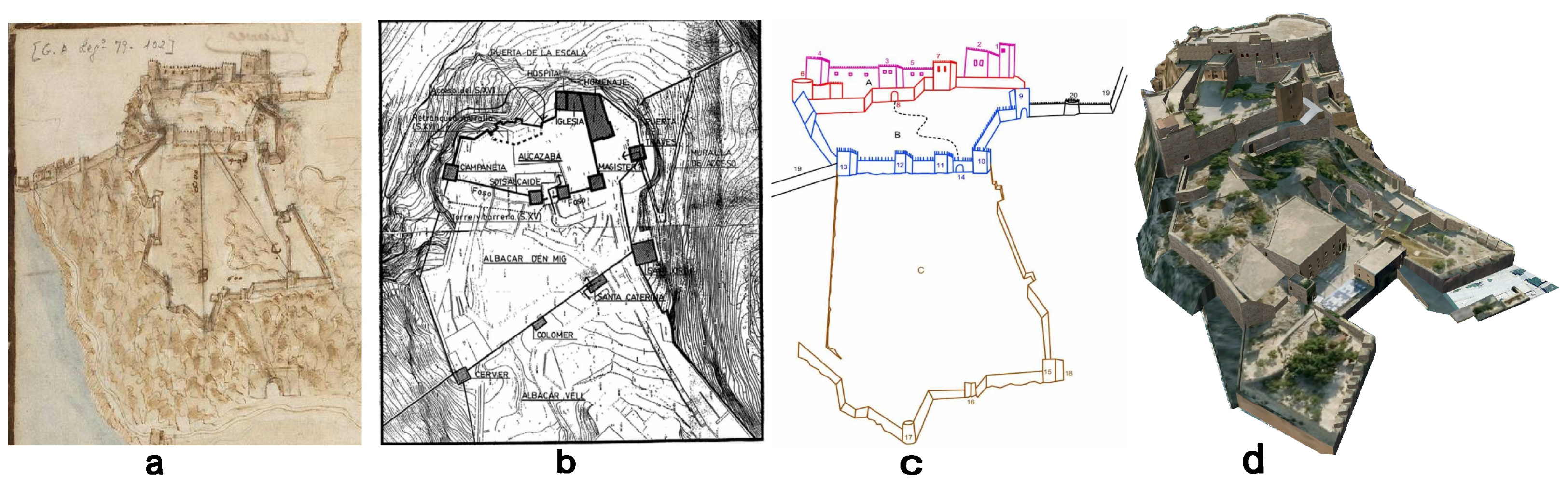
In
Figure 2, we depict the evolution of the fortress over time using archival documents and archaeological data in panels (a) and (b), respectively. The constructive morphology of the Santa Barbara Fortress is reconstructed in panel (c), allowing a comparison with its current state in panel (d). This comparison shows the overall state of preservation of the fortress, where the disappearance of a few towers is noted. We identified six representative cases for each typology (see
Figure 3), which can be categorized into four main groups based on their temporal evolution within the contexts of Northern Algeria and Southeastern Spain:
Fortifications erected between the 8th and 10th centuries.
Fortifications established during the 11th and 12th centuries.
Fortifications built between the 13th and early 15th centuries.
Spanish fortifications in Algeria from the late 15th to the early 17th century.
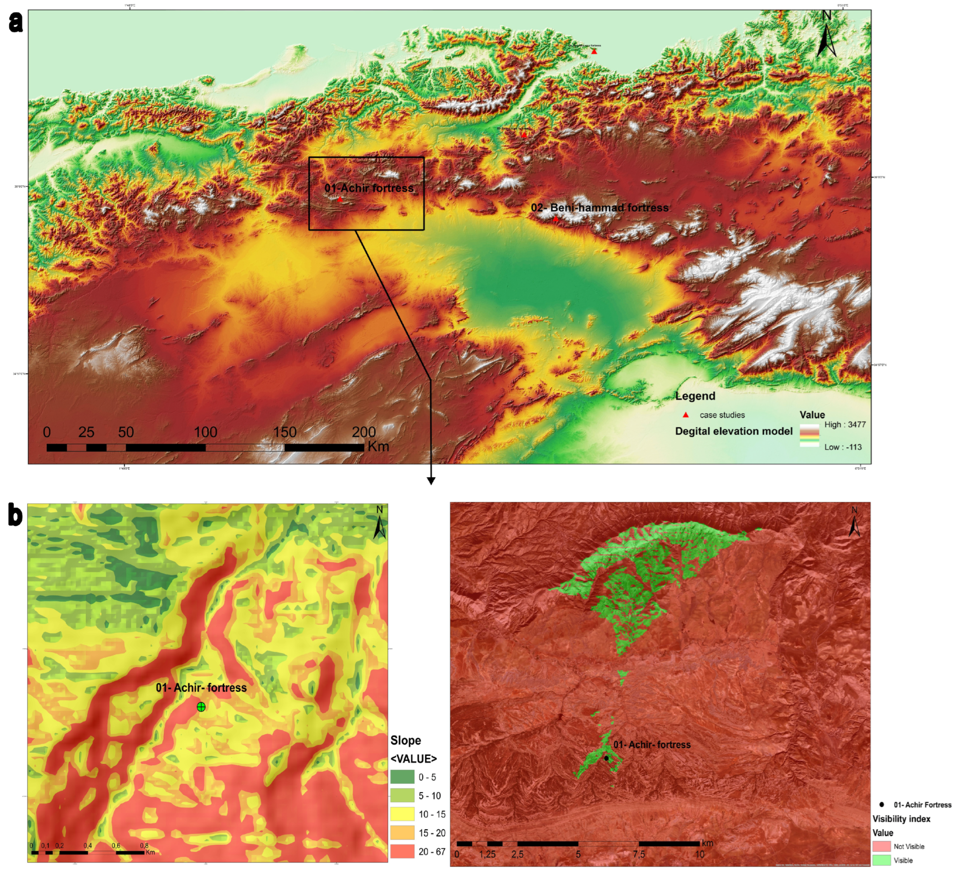
Early Muslim Period Fortresses (8th to 10th Century): The initial fortifications during the Muslim period featured towers, either square or round, often adjacent to ramparts or standing alone as bastions. These forts were influenced by Byzantine designs and were situated on ancient bases that were subsequently occupied by the early Muslims. For instance, Fort Achir adopted this architectural pattern, featuring a stone wall surrounding the site, reinforced by towers and a defended gateway. The square-shaped construction exhibited remarkable regularity, forming a rectangular structure measuring 72 m by 70 m [
11].
Middle−Eastern−Inspired Fortresses (11th to 12th Century): Fortresses constructed during the 11th and 12th centuries were influenced by Middle Eastern architectural models. These isolated fortresses featured sloped bases, typically encircled by ditches and equipped with flanks. Their designs were adapted to the topographical characteristics of their locations. The Kalaa of Beni-Hammad, a UNESCO World Heritage site since 1980, serves as an exemplar. Situated on the southern slope of Mount Maadid on Algeria’s north coast, this fortress incorporated a top-level defense system. It employed the strategy of alternating empty slots and full elements at the top of the tower to provide soldiers with an extensive field of view while affording protection during rearmament [
39].
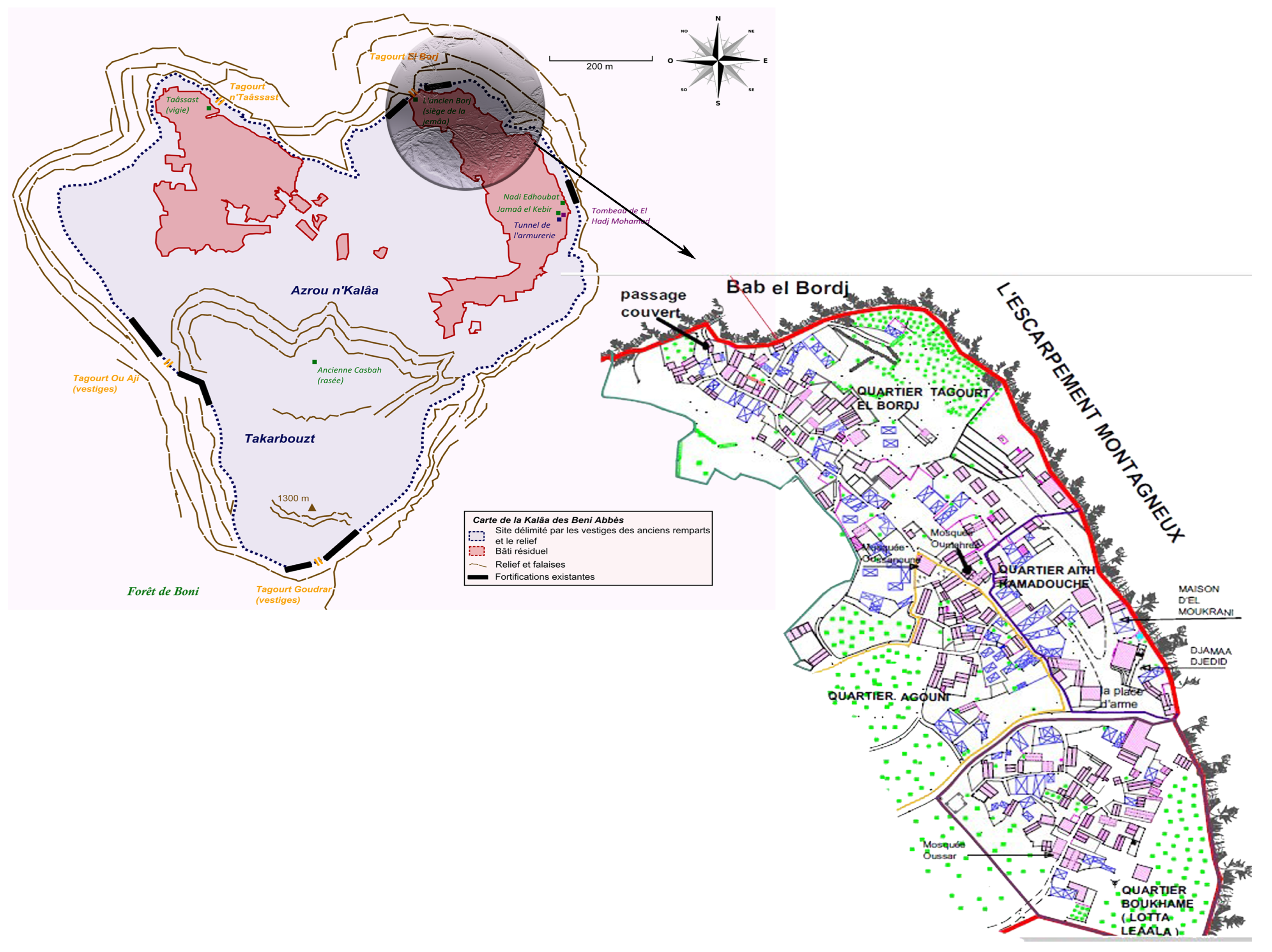
Indigenous−Inspired Fortified Villages (13th to early 15th Century: During this period, defensive villages were established, respecting indigenous architecture and located in specific contexts. Muslim conquerors reclaimed sites previously inhabited by local populations, fortifying them to create fortified villages. One such case is the Kalaa of Beni-Abbès in Bejaia, a fortified village perched atop the Bibans mountain range. The village’s strategic location, positioned away from the communication routes of the time, enabled it to connect Tunis (Tunisia) and Constantine (Algeria) while providing a defensive aspect. The Kalaa replicated the architecture of traditional mountain villages, expanded and fortified with additional features such as artillery posts, watchtowers, and armory barracks. The village entities were compact and intra muros, with houses aligned perpendicular to the level curves, forming an outer enclosure that enhanced defensibility [
40].
Spanish Fortifications in Algeria (Late 15th to Early 17th Century): Due to political, economic, and religious motivations, the Spaniards established a presence in North Africa, extending the Reconquista into the late 15th and 17th centuries. They occupied major Algerian coastal cities, including Bejaia, Oran, and Algiers. This period left a substantial impact on the military archives of Simancas and the Ministry of Defense archives in Madrid.
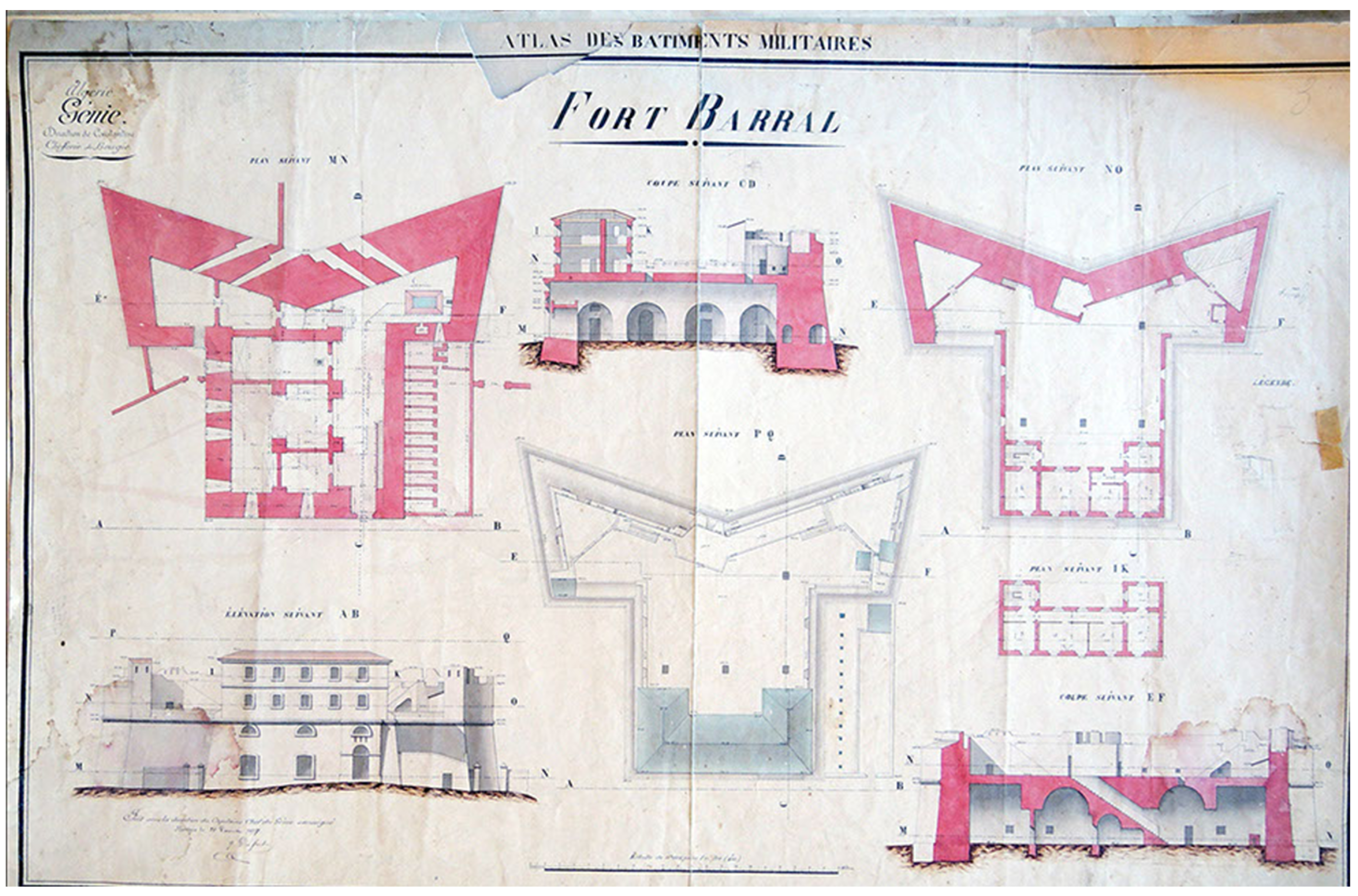
Notable among the architectural contributions of the Spanish period in Algeria’s Mediterranean coast is the Imperial Fort Burdj Moussa (see
Figure 4). This fortress signified the introduction of a new typology, aligning with evolving war strategies. It complemented an existing network of fortifications established through prior conquests, including the casbah and the sea fort known as Abdelkader Fort [
41]. The Imperial Fort typifies Spanish military fortresses of the medieval era, with its layout designed by Italian engineer Librano.
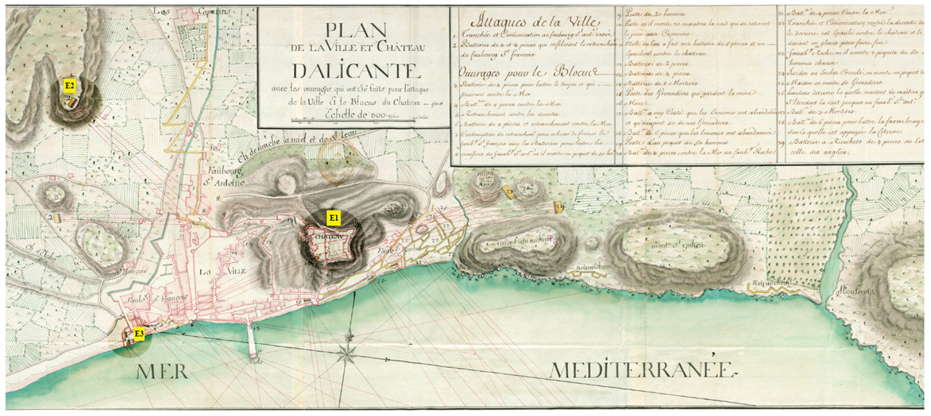
The construction of Santa Cruz Fortress (
Figure 5) took place between 1577 and 1604. It occupies a strategically significant position, serving a dual purpose: to monitor both bays of Oran and establish communication with other forts within the city. The Spaniards paid particular attention to this stronghold, repeatedly modifying and fortifying it to defend against Mediterranean-side attacks. Its location also facilitated an underground communication network connecting various forts across the entire city. This network was reliant on galleries dug beneath the city’s surface.
As depicted in
Figure 5, Santa Cruz Fortress comprises five defense components: bastions, an enclosure, a ditch, gates, and additional forts. The defensive system took its final form in 1734, following renovations and reinforcements by engineer Juan Ballaster, which included adding fortifications to the enclosure’s periphery [
42].
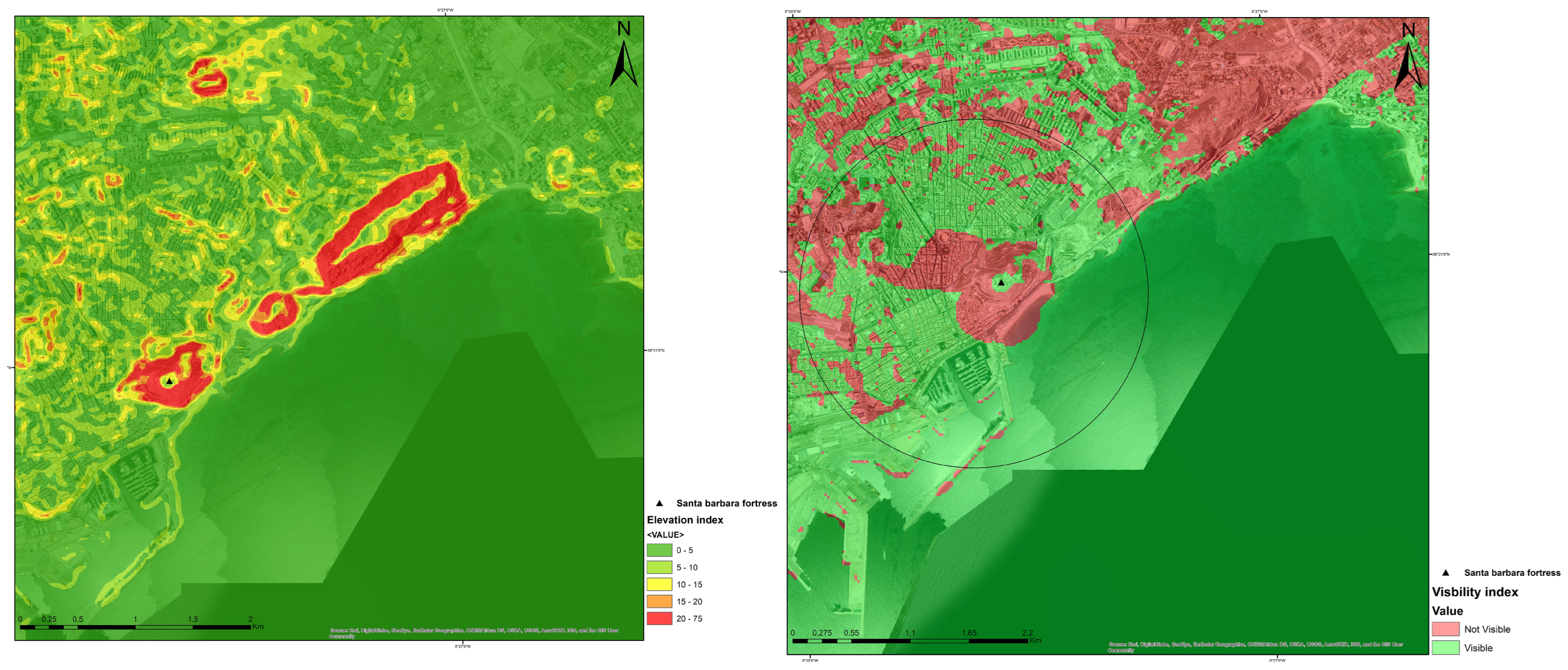
The summit of Benacantil in Alicante has long been renowned for offering breathtaking views of the Valencia province’s coast and the southeastern coast of Spain [
12]. Santa Barbara Fortress, as shown in
Figure 6, originally featured a defensive wall built during medieval times by the Almoravids. They established on their mount the first fortified space called “Albacar” [
31,
32,
33], equipped with a cistern where the rural population and caravans sought refuge. This initial structure evolved to form today’s complete castle, in which the Muslim part, the subject of our study, was preserved. Alicante was under Muslim occupation due to its reputation as a hub for constructing commercial ships and boats. Nearby, a port hid warships destined for surrounding regions, providing effective defense [
43].
Our knowledge of Santa Barbara Fortress’s origins is primarily derived from transcripts by archaeologist Pablo Rosser and Azuar Ruiz [
32]. These transcripts confirm the existence of a well-fortified structure atop Mount Benacantil in Alicante, surrounded by a Muslim wall strengthened by substantial towers. The discovery of architectural remnants from this era resulted from surface findings and archaeological excavations conducted by COPHIAM [
12,
32].
5. Results and Discussion
To understand the development of defensive systems in medieval fortresses along the Mediterranean coast and how site selection influenced their design, we conducted a detailed study of six representative cases in both Algeria and Spain.
In
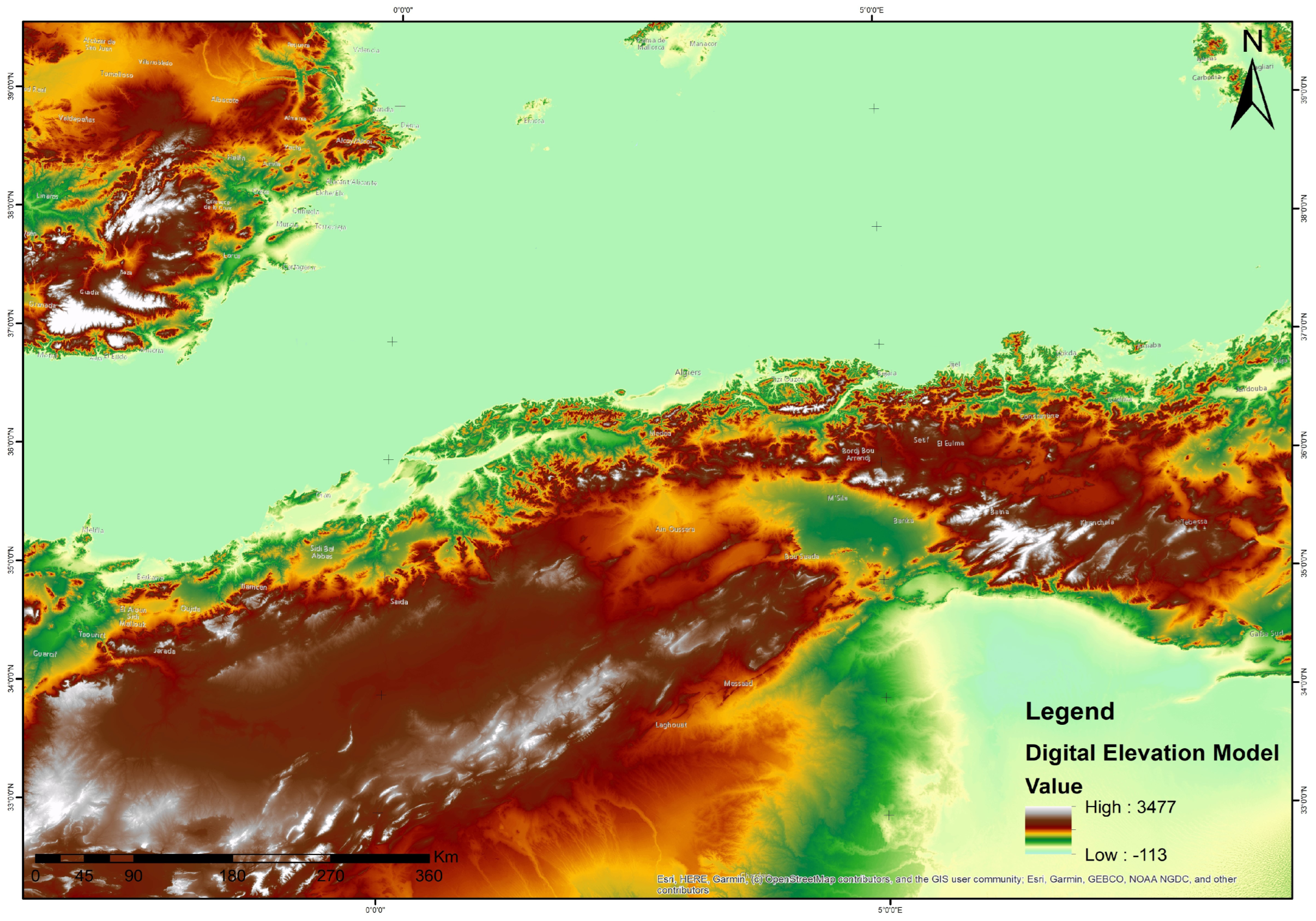
Figure 7, we show a Digital Elevation Model (DEM) of the area under consideration with a resolution of 30 m. Derived from the ASTER Global DEM V.2, 1 arc second data set, a product of NASA Earth data, it was prepared by re-projecting the ASTER GDEM V.2 from its native latlong coordinate system and WGS84 to the Universal Transverse Mercator (UTM), Zone 30N for Northern Algeria, and 31N for Southeastern Spain. The sites did not undergo significant changes in altitude or geographical configuration over time. The fact that fortresses are situated at higher locations within the city or in mountainous areas supports this notion of stability.
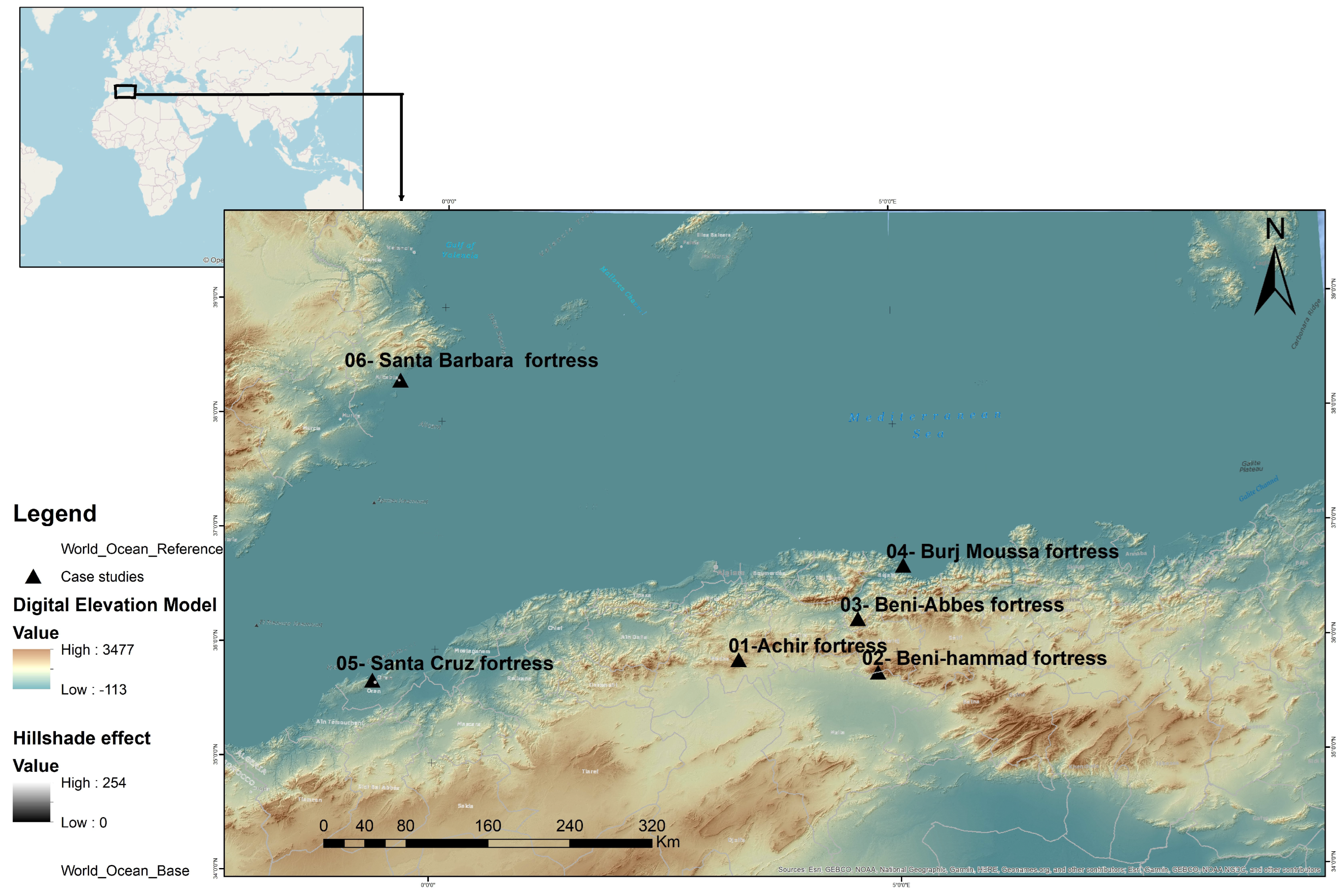
Figure 3 provides an overview of our study area, illustrating its location in the Mediterranean basin. This figure was created using the Hillshade function in ArcGIS and offers a 3D grayscale representation of the area’s elevation and azimuth properties.
Essential data are presented in
Table 1, namely visibility, elevation, and defensiveness metrics for each fortress under investigation. These metrics were computed based on the approach developed by Martindale and Supernant [
16]. Additionally, we evaluated visibility, intervisibility, and elevation, leveraging the ArcGIS 3D spatial analyst extension on the raster landscape (DEM) for each case study.
Visibility: was determined using the arc length (in degrees) of visibility over land and water beyond 100 m from the site’s center, divided by the total arc length of approach around the site, rather than relying on slope, resulting in a value between 0 and 1 [
16].
Elevation: advantage was assessed by measuring the difference in elevation between the highest point within the site and access points at the site’s edge, ranging from 0 to 1 [
16].
The area was divided by 1,000,000
and then integrated into the defensiveness index to account for site size and its potential population capacity [
16].
Each of these metrics serves to evaluate the defensibility of a spatial system that separates inhabitants from external threats. The calculus acts as an estimation of architectural structure and does not aim to precisely quantify the suitability of specific defense mechanisms against different attack scenarios. Instead, it offers a generalized measure, an attempt to quantify what is commonly assumed in discussions related to defensive sites [
16].
with
being negligible in our context, we refer to the supplementary study of R. Kyle Bocinsky [
18], which suggests it is feasible to calculate the DI based solely on elevation and visibility.
The OFFSETA(m) parameter represents a vertical distance measured in meters, which must be added to the z-value of the observation point. In our case, this value corresponds to the fortress height added to the altitude relative to sea level. This parameter holds critical significance in our study, as it refines the accuracy of the data related to wall height measurements.
Model: In our study, we designated three models: the original model: the fortress was designed by Muslim conquerors using their expertise; the superposed model: this implies that the fortress is superimposed on an existing foundation; and the inspired model: a typical fortress model imported from a conquered site and constructed elsewhere.
Based on these initial empirical findings, we can already draw conclusions regarding the correlation between the defensiveness index (DI) and architectural typology. In order to more comprehensively analyze this defense parameter and the influence of site selection within the context of our study, we have opted to employ Geographic Information Systems (GIS). Detailed results will be presented in the subsequent sections of our article.
In this phase of our study, we conducted two main analyses. First, we assessed visibility from observation points within each fortress to calculate the visibility index. Second, we analyzed how well each fortress could see and be seen by other surrounding defensive structures. In the graphical representations, green cells indicate areas with good visibility, while red cells indicate areas with poor visibility. The elevation index is represented by a slope diagram, with steeper slopes in shades of red and gentler slopes in shades of green.
The earliest fortresses along the Northern Algerian coast were strategically placed behind a mountain range, as seen in
Figure 8a, to hide them from view and protect against potential sea-based invasions. These fortresses were situated on moderately steep slopes.
Figure 8b shows the relationship between elevation and visibility. During this period, the strategy was to seek protection behind the natural landscape features, leading to fortress designs with towering walls, bastions, and control towers. The aim of this design was to minimize visibility from the Mediterranean side, as shown in
Figure 8b. In this section, we applied the technique to the first defensive architectural typology of the medieval period in Algeria, “Fort d’Achir” as a proof of concept.
Transitioning to the second phase of conquest, specifically focusing on fortified villages, we noticed that for the fortress of Beni-Abbès in Béjaia, the elevation and visibility indices played a more critical role. Unlike the first type of fortress, this one was strategically positioned on a steep slope and had an open view toward the Mediterranean. This placement allowed the fortress to have a substantial field of vision, effectively controlling the line of attack. The choice of this location has influenced the fortress’s design, which harmoniously follows the natural contours of the land. Interestingly, this fortified village had only one protective wall on its seaside facing the sea, with the entire rear side shielded by the mountains, as seen in
Figure 9. Consequently, there was no need for fortifications on the seaside, a decision also influenced by economic considerations. Along with its improved visual coverage and control over the north side (facing the Mediterranean), this location made smart use of the natural mountainous terrain as an economic enclosure solution, enhancing its practicality.
The intricate interplay between the natural landscape and strategic considerations of elevation and visual prominence elevated the defensive significance of the fortress. This was further strengthened by the addition of a partial enclosure, protecting the vulnerable areas exposed to potential attacks from the sea, as depicted in
Figure 9.
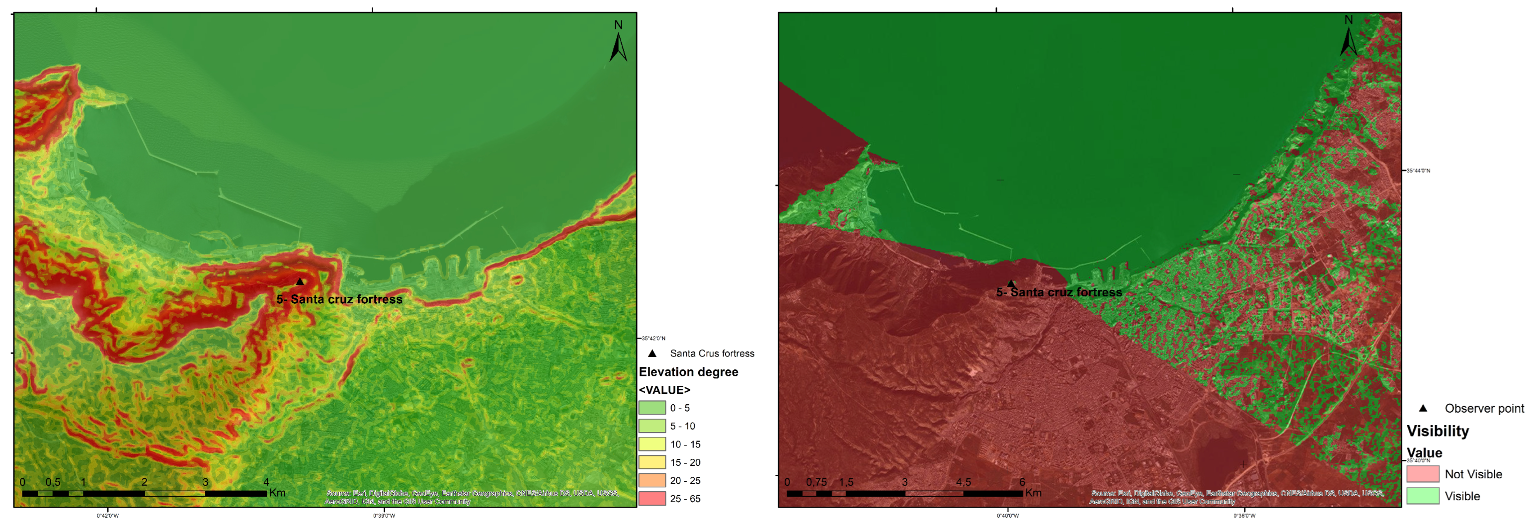
In the same context, concerning the imported model typology, as previously explained, the Spaniards introduced a new type of fortification that complemented the existing castle network in the city of Béjaia. They positioned these fortifications directly along the coastline, with the aim of achieving maximum visibility of the sea. As shown in
Figure 10, both the visibility and elevation were notably high. The Santa Cruz Fortress, situated atop the city’s highest peak, provided optimal control against maritime threats by overseeing a vast area. With the elevation index reaching 65%, as depicted in the rendering to the left in
Figure 10, the red color indicates the highest point where the fortress is located. As for visibility, as we can observe in the rendering to the right in
Figure 10 that the entire bay of the sea is visible from the Santa Cruz Fortress (green field), enabling the control of attacks originating from this angle (the sea).
In contrast to the earlier isolated fortresses, the Spaniards strengthened the city’s defensive system. To understand the defensive strategy of this period, we conducted an analysis of intervisibility among the various fortifications within the same system.
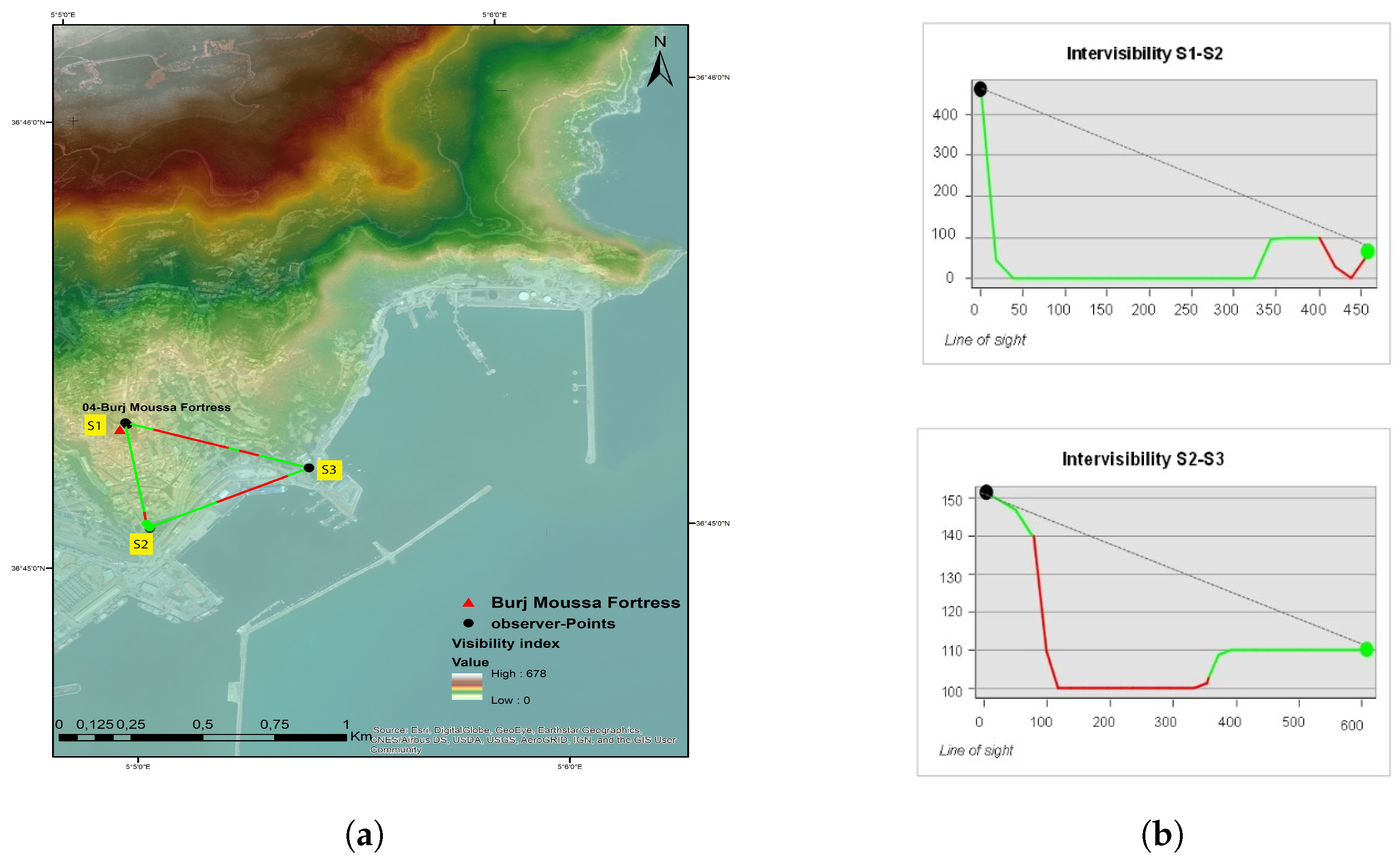
Figure 11a illustrates the results of the line-of-sight analysis, revealing visual communication between previously conquered fortresses like Casbah S2 and Fort Abdelkader (Fort of the Sea) S3. Additionally, the intervisibility between the imperial fortress Burdj Moussa S1 and the surrounding fortresses allowed for rapid alarm signaling in case of an attack.
On both construction and defense fronts, the Spaniards chose to create lateral strongholds (
Figure 4) for military purposes. These strongholds facilitated crossfire against attackers approaching the fortresses and established intervisibility between the two forts. As seen in the graphical representations in
Figure 11b, the fortress was visible from both forts, enhancing their defensive effectiveness. During this era, it evolved from an isolated structure into a defensive complex consisting of three main fortresses: S1 (Imperial Fort Budj Moussa), S2 (Casbah), and S3 (Fort of the Sea), forming a triangular defense strategy, as depicted in
Figure 11.
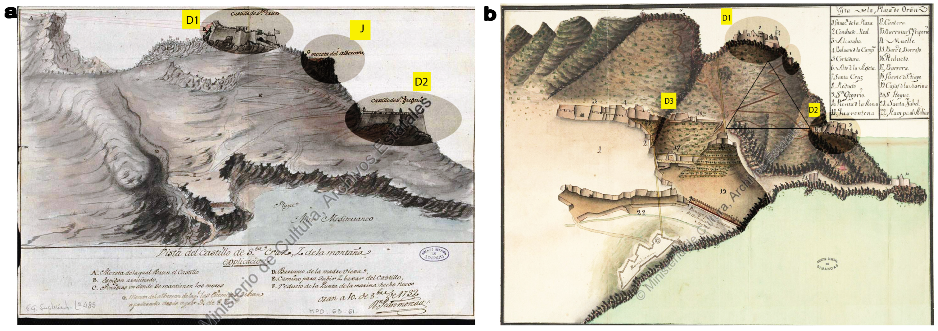
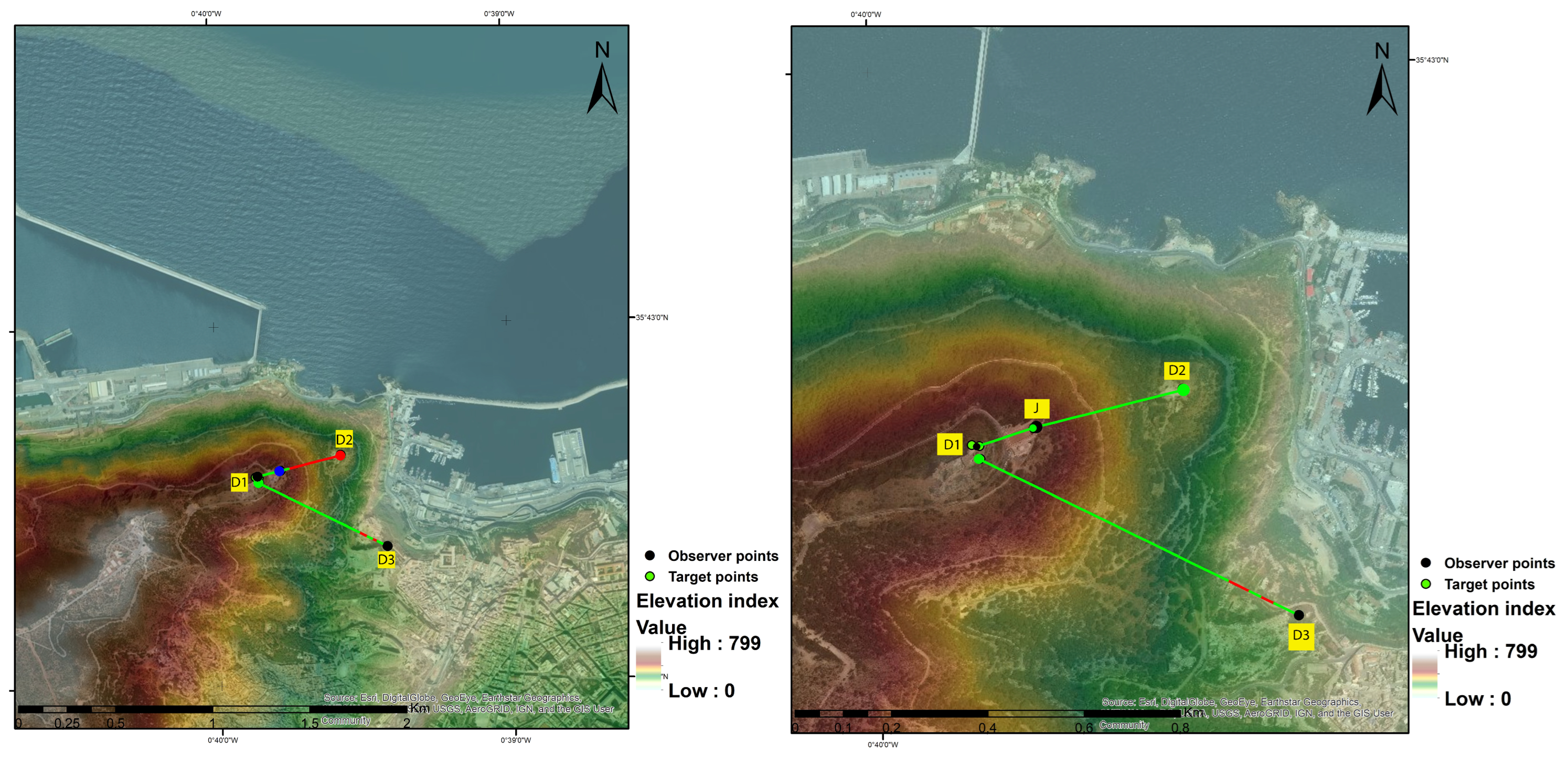
We observed a similar strategy used by the Spaniards in Oran, as shown in
Figure 12. The aim of such a system of intervisibility is to eliminate vulnerabilities in controlling the flanks of the primary fortress. Our assessment involved examining visibility, elevation, and line of sight (LOS). The results indicate that the primary fortress, Santa Cruz D1, is situated at the highest topographical point within the city, as illustrated in
Figure 12b. We then selected point D2 as a target, and the 3D line representation was derived from archival documents. Regarding the results in
Figure 13, the black point represents the observer’s location at D1, and the red point signifies the target’s location at D2.
The 3D linear line of sight is displayed in a profile graph in
Figure 14. Notably, there is no visibility between the observer point D1 in the Santa Cruz Fortress and the target D2. To bridge this visibility gap and ensure control of zone D2, the Spaniards constructed a linear extension from the fortress at point J (depicted as a blue point on the graph). We consider this extension a connecting fortress, strategically positioned at a lower altitude than the main fortress, as shown in
Figure 12b. Zone D2 is visible from this connecting fortress, which, in turn, relays signals back to fortress D1 via point J, establishing a comprehensive defensive communication network.
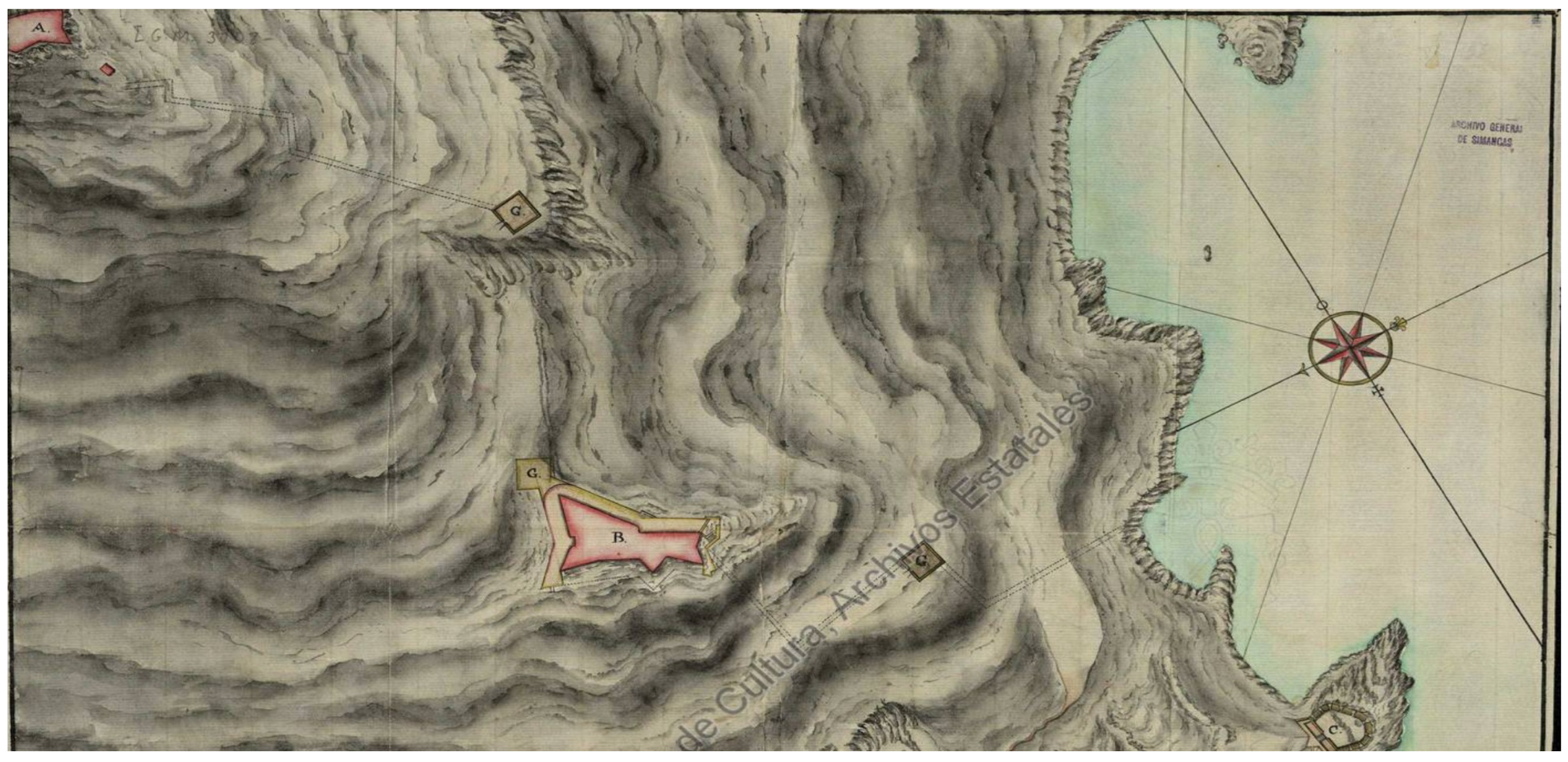
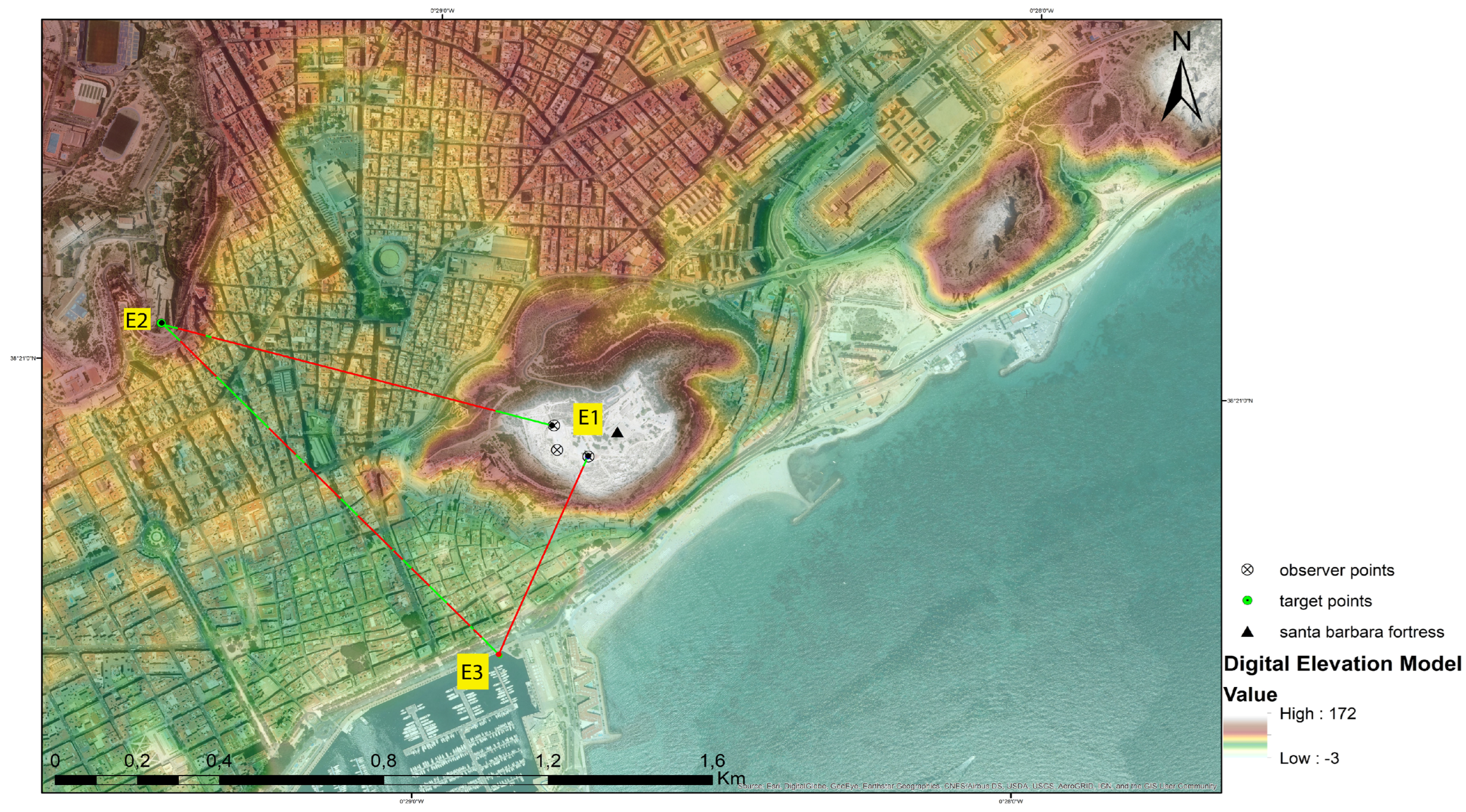
The strategic approach we observed in the Algerian context was also implemented in Spain, specifically in the case of Alicante on the southeastern coast. During the Muslim occupation, architects adapted the Spanish defensive strategy. Much like in Béjaia and Oran in Algeria, they embraced the idea of positioning their fortresses with a view toward the sea to ensure optimal visual coverage.
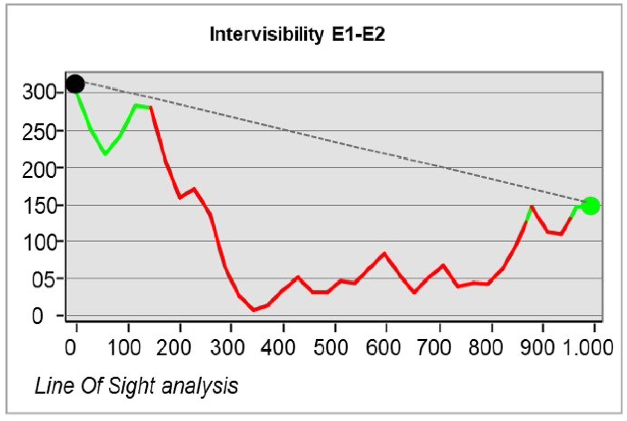
The results from the line-of-sight (LOS) analysis revealed the intervisibility between Santa Barbara Fortress E1 and San Fernando Castle E2, as shown in
Figure 15.
However, within a distance of ≥100 m and at a very high elevation, visibility from the fortress was almost non-existent, as seen in
Figure 16 (right). To address this limitation, the fortress was strategically oriented to establish intervisibility with San Fernando Castle. The results of this analysis are depicted in
Figure 17.
We focused our examination on a specific point within close proximity to the fortress, ≤100 m away. The results of the 3D linear line-of-sight analysis demonstrate the lack of visibility between observer point E1 at Santa Barbara Fortress and target point E3
Figure 16. To overcome this challenge, another observer point was established at San Fernando Castle E2, located at a lower altitude. This observer point, in turn, maintained communication with Santa Barbara Fortress E1. The line-of-sight analysis in
Figure 16 revealed the visibility between points E2 and E3.
Our analysis results emphasize that to enhance defense effectiveness along the vulnerable Mediterranean coast, especially against sea-based attacks, it was crucial to strengthen control by establishing both visual and physical connections with existing fortifications.
The intricate relationship between the site’s context and the defensive configurations of medieval fortresses along the Mediterranean coast resulted in a high value for the defense index, which is closely linked to the visibility and elevation indices. However, as observed in some instances, this high visibility and elevation were not always sufficient for effective control at close distances, particularly within ≥100 m. To address this limitation, builders of this era implemented a defensive strategy involving a network of interconnected fortresses. These fortresses communicated with each other and exchanged alarm signals in the event of an attack. In other words, while the vertical dimension of the site provided maximum visibility at significant distances, it may have been less effective for distances closer to the fortress, especially those ≥100 m.
Theduality of visibility and elevation in the context of the Mediterranean coast.
Our findings revealed a close connection between the evolution of medieval defensive systems along the Mediterranean coast and the characteristics of the landscape, including its physical elements. The interplay between visibility and elevation and their impact on the six study cases underscores the significance of these factors in the defensive effectiveness of fortresses.
6. Conclusions
Our study aimed to assess the defensive characteristics of medieval fortresses along the Mediterranean coastline, leading us to conclude that their defensive effectiveness is primarily determined by their location. We conducted evaluations of visibility and elevation, considering these factors to be crucial in shaping the strategic choices made for fortified sites. Indeed, the natural landscape features of the regions where the examined fortresses were located significantly influenced the development of their defense systems. During the initial period of the conquest, fortress visibility was intentionally obscured, leading medieval builders to prefer an isolated and introverted architectural design. Site selection itself was driven by strategic considerations. Subsequently, we observed a shift toward more exposed coastal locations with higher visibility and elevation indices.
Our analysis of intervisibility within a system of fortresses, conducted through line-of-sight (LOS) analysis, revealed a new defensive strategy initially employed by the Spaniards and later adapted by the Muslim conquerors: the triangular strategy. This approach involves the exchange of alarm signals between three fortresses within the same system in the event of an attack.
Through this research, we aimed to illustrate that beyond the sociopolitical, cultural, and economic factors influencing the design of these fortresses, medieval builders have demonstrated remarkable acumen in selecting optimal locations and elevations. Their ingenuity was directed toward maximizing the defensive effectiveness of these structures.
Our approach was inspired by the work of Martindale and Supernant [
16], where the methodology was initially applied to the northwest coast of Canada. We adapted their methodology to our unique contexts, covering Northern Algeria and Southeastern Spain; while the contexts may vary, the mutually beneficial relationship between human settlements and their natural surroundings remains constant. This principle is particularly evident in times of conflict where the physical attributes of the implantation site are among the primary considerations for achieving an optimal degree of defensibility.
The evaluation of the defense level and effectiveness of these fortresses involved a comparison to their current state, considering such factors as duration of usage and attack frequency. Our models demonstrated perfect resilience over time, highlighting the importance of site selection during conflict periods. This also highlights the pivotal role of visibility and elevation factors in defense against attacks by medieval fortresses on the Mediterranean coast. This contribution represents a starting point for future research, opening up new perspectives. As attention is often focused on religious monuments during this period, medieval defensive architecture has been significantly underexplored.


 ,
, 


