Article

A Novel Method of Modeling Grassland Wildfire Dynamics Based on Cellular Automata: A Case Study in Inner Mongolia, China

1
School of Geographic and Oceanographic Sciences, Nanjing University, Nanjing 210093, China
2
Inner Mongolia Ecology and Agro-meteorology Centre, Hohhot 010051, China
3
Nanjing Retinar Information Technology Co., Ltd., Nanjing 210046, China
*
Author to whom correspondence should be addressed.
ISPRS Int. J. Geo-Inf. 2023, 12(12), 474; https://doi.org/10.3390/ijgi12120474
Submission received: 14 September 2023 / Revised: 8 November 2023 / Accepted: 19 November 2023 / Published: 21 November 2023

Abstract

:
Wildfires spread rapidly and cause considerable ecological and socioeconomic losses. Inner Mongolia is among the regions in China that suffer the most from wildfires. A simple, effective model that uses fewer parameters to simulate wildfire spread is crucial for rapid decision-making. This study presents a region-specific technological process that requires a few meteorological parameters and limited grassland vegetation data to predict fire spreading dynamics in Inner Mongolia, based on cellular automata that emphasize the numeric evaluation of both heat sinks and sources. The proposed method considers a case that occurred in 2021 near the East Ujimqin Banner border between China and Mongolia. Three hypothetical grassland wildfires were developed using GIS technology to test and demonstrate the proposed model. The simulation results suggest that the model agrees well with real-world experience and can facilitate real-time decision-making to enhance the effectiveness of firefighting, fire control, and simulation-based training for firefighters.

1. Introduction

Wildfires are common phenomena in almost all natural area ecosystems [1,2,3,4]. They cause immense and irreversible damage, with deep ecological and socioeconomic impacts [5,6,7,8,9]. According to Tian [10], an average of 10,116 wildfires occurred each year from 2008 to 2012 throughout China. Among all the provincial administrative divisions, Inner Mongolia has the second-most extreme weather during summer [11]. Many Chinese still remember the large-scale forest fires of May 1987 in the Greater Khingan Range, which killed 193 people, destroyed over 1 million hectares of forest, gutted approximately 614,000 square meters of residential areas, and had a far-reaching impact on China’s forest management policies [12].
Many studies have explored wildfires to devise smart solutions to protect lives and property and manage natural fuels [13,14,15,16,17,18,19,20,21,22,23,24,25]. However, the safe and effective control of wildfires and fire management largely depends on the ability to predict fire behavior as accurately as possible [26,27,28]. Therefore, several wildfire models and systems such as the Fire Behavior Prediction (FBP) model, FARSITE, Prometheus, SiroFire, and BEHAVE have been established worldwide [21,22,23,24,25,29,30,31,32,33,34]. These models enable real-time decision support to enhance the effectiveness of firefighting, fire control, and simulation-based training for firefighters.
The model types are mainly classified as physical, semi-physical, and empirical and are important because all present calculation systems are based on them. The most basic notions of wildfire dynamics, topography, and weather effects in fire spread, heat transfer mechanisms, fire behavior features, etc., benefit from fire spread modeling [14,29,35,36]. However, none of the established models can comprehensively simulate wildfire dynamics [37,38,39]. This is because the spread of fire through any fuel bed involves many complex chemical and physical processes, as well as complex natural topography, local-to-microscale climatic conditions, and their interactions [13,27,40,41,42,43].
Empirical models are statistical descriptions of wildfires and do not attempt to include any physical mechanisms that drive the fire process [44,45]. Notable examples include models developed by McArthur in Australia and the FBP model developed by Stocks in Canada [46,47]. These models have been successfully used in a range of fire-prone ecosystems, forming the basis of the Australian and Canadian fire danger rating systems [48]. However, their lack of a physical basis implies that they can only be used cautiously outside the test conditions because empirical models cannot be easily extrapolated beyond the conditions in which they are formulated [29,37,49,50,51].
Physical models are based on mathematical analyses of the fundamental physical and chemical processes of fire spread and do not involve the analysis of actual fire events [29,45,52,53]. Almost all physical models have been developed based on the first principles of the physical and thermodynamic properties of the processes that control the spread of fire [14,16,54]. The major advantage of rigorous physical models is that they are based on known relationships, which facilitates their scaling [16,35,44]. Furthermore, they provide insights into the wildfire mechanisms and form the basis of the most advanced model simulation systems [29,49]. However, these models are generally based on the idealization of fuel, fire lines, and flames in a simplified system, in which the complexity of fire dynamics cannot be thoroughly expressed [15,17,37,44,55]. For example, almost all physical models consider radiation as the dominant process in the unburnt fuel heat contribution; however, few treat the convective part appropriately [29]. The relative significances of radiation and convection vary from fire to fire, and estimating their exact combination is difficult. These difficulties prevent the extensive operational use of physical models [44,49].
Semi-empirical models are based on the observation of small-scale experimental fires and use physical analyses to maintain the similarity of processes across scales; that is, they combine physical and empirical techniques [48]. The most popular semi-physical model to date was developed by Rothermel and incorporated into the USA National Fire Danger Rating System and BEHAVE fire prediction system [13,31,56]. The Rothermel model was developed to predict the rate of fire spread at the fire front in an environment with fuel, weather, and topography effects, and has been widely used in a range of ecosystems [29,44,57]. However, despite the popularity of the model, its application in China is rare, partly because it was designed in North America, where the forest fuel model differs significantly from that in China. Additionally, it requires more than 10 parameters as inputs, which is a burdensome and time-consuming task that is yet to be performed in China [58,59]. However, Inner Mongolia has vast grasslands where wildfire spread dynamics are quite simple, and the application of the Rothermel model is too complicated in this region. Additionally, as a meteorological bureau, it is our duty to provide technical support to the local government for decision-making in the case of fires. Therefore, we intend to devise a simple and easy method for fire spread prediction that utilizes the enormous amount of meteorological data and products at our disposal.
Overall, these methods have relatively complex parameters and modeling, but grassland fires develop rapidly. In actual fire management, fire spread models must have a fast response speed, but it is difficult to support rapid judgment and decision-making for grassland fire monitoring. The vegetation in the Inner Mongolian grasslands is relatively simple and mainly affected by meteorological and terrain factors. The main purpose of this study was to develop a simplified model to guide the rapid response and prevention of grassland fires. Considering the simple structure and low computational complexity of the cellular automaton model, we propose a new method for modeling the dynamics of grassland wildfires based on cellular automata (CA). This method combines the growth stages of wildfires with meteorological and terrain factors to describe the cell state quantitatively. This refines the CA and enables the model to provide rapid decision support for real-time fire simulations.

2. Materials and Methods

The proposed method for modeling grassland wildfire dynamics is based on the CA model. CA has been widely used as a simple model of computation but is capable of simulating complex behaviors [60,61], such as the simulation of snow crystal growth processes [62,63,64]; urban dynamics [65,66,67,68]; self-reproduction, which is a major factor in the development of a system [69]; image processing [70,71]; and epidemic propagation [67,72]. The CA model has been popular for wildfire simulations over the last few decades [48,73,74,75,76,77,78,79,80,81,82].
Generally, a CA is a dynamic system in which both time and space are discrete. Thus, in the sense of wildfire simulation, forest areas or wildlands are divided into a two-dimensional array of identical squares, each of which represents a small part of the fuel bed, interacting locally with each other. Furthermore, each cell has finite states that change at every discrete-time step, according to a set of deterministic local rules. Therefore, a wildfire spreading procedure in a two-dimensional finite CA can be defined as a 4-uplet, using Equation (1).
Φ   = ( C ,   S ,   N ,   R )
where C is the cellular space formed by an array of m × n identical cells, C = { i ,   j ,   0     i < m ,   0     j   <   n ,   i ,   j ,   m ,   n     Z } ; S denotes a finite cellular status set; N implies the neighborhood; and R defines the local rules [83].
According to Karlsson [84], a typical combustion development comprises three phases: growth, full development, and decay (Figure 1). Therefore, to simplify the fire dynamics, the state set S can be described as a set of five members: unburnt, growing, fully developed, decaying, and extinguished; the state of a cell, cij, at time t is denoted as c. Thus, the state of cell c at time t is tij using Equation (2).
S = { unburnt = 0 ,   growing = 1 ,   developed = 2 ,   decay = 3 ,   extinguished = 4 }
Each cell, cij, has its neighborhood, Nij, which is an ordered set of cells using Equation (3).
N ij = { i + r ,   j + s ,   | r | ,   | s |     k ,   r   ,   s     Z ,   k     Z * }
However, the Moore Neighborhood is most commonly used; that is, k = 1 (Figure 2). In this case, the model distinguishes two types of neighbor cells: adjacent neighbor cells, one of whose variables (r or s) is set to zero, and diagonal neighbor cells, the remaining four in the neighborhood.
The model evolves in a discrete-time step and transfers the states of its cells according to a set of local rules using Equation (4).
c ij t + 1 = R ( N ij t )
This implies that the updated state of a cell at time t + 1 depends on its neighborhood cells and is settled by local rules 1–5 [85].
Rule 1. If c ij t = 4 , then c ij t + 1   = 4 ;
Rule 2. If c ij t = 3 , and t + 1 > T3, then c ij t + 1 = 4 ; otherwise, c ij t + 1   = 3 ;
Rule 3. If c ij t = 2 , and t +1 > T2, then c ij t + 1   = 3 ; otherwise, c ij t + 1 = 2 ;
Rule 4. If c ij   t = 1 , then c ij t + 1 = 2 ; otherwise, c ij t + 1 = 1 ;
Rule 5. If c ij t = 0 , then the cell will ignite depending on the possibility Prisk.

2.1. Ignition Risk

The spread of fire through fuel beds involves several complex chemical and physical processes [13,45,54]. However, heat is generally supplied from the fire front to the unburnt fuel; subsequently, the fuel surface is dehydrated, and further heating increases the surface temperature until the fuel begins to pyrolyze and release combustible gases [13]. When the gas from the unburned fuel is sufficient to support combustion, it is ignited by the flame, and the fire advances to a new position. Thus, fire propagation in a fuel bed can be visualized through a series of successive ignitions [13,40].
Therefore, theoretically, every unit of unburnt fuel has an ignition risk when the fire front approaches, which may vary from place to place because of the complexity of the natural topography, local microscale climatic conditions, and their interactions. The modeling of grassland wildfire dynamics utilizes ignition risk to describe the possibility given by the following formula, which is the same as that for the fire front:
P risk = i = 1 N P i = f   ×   F   ×   i = 1 N ( I i   ×   d i )
where Prisk is the total ignition risk of an unburnt cell; Pi is the ignition risk contributed by its neighbor; F stands for the flammability of the fuel bed of the center cell, determined by intrinsic characteristics of the fuel and weather conditions; Ii describes the heat that the fire spreads from a burning cell to its neighbors, which is highly relevant to the fire front intensity; di is a distance weight; and f is a constant factor, f ∊ (0, 1].

2.2. Flammability

The flammability of fuel beds is affected by many factors such as physicochemical properties, biological characteristics, structure, permutations, species, and weather conditions [86], which significantly determine the degree of ease of ignition and fire suppression difficulty. Although flammability as a property of fuel beds has been discussed for decades [87,88] and is readily appreciated in a general sense, it is still difficult to define it scientifically [89,90,91].
Many empirical relationships have been discussed regarding the flammability of fuel beds, and a recent study was conducted by Cui et al. [92]. The equation provided by Cui et al. [92] was based on the statistics of hundreds of wildfire events from 1994 to 2005 in Inner Mongolia and described the fire risks in a relationship with selected weather conditions, written in a logistic regression model, as follows:
Logistic F i = 1.387 + 0.518 · W s 0.032 · H r 0.320 · P r + 0.043 · T e + 0.037 · G v
where Fi denotes the flammability of the fuel beds at a given location; Ws denotes the wind speed (m/s); Hr is the average relative humidity (%); Pr implies daily precipitation (mm); Te refers to temperature (℃); and Gv stands for the grass species classification value (Table 1). However, if the fuel beds are non-combustible, such as pools and large rocks, Fi = 0.

2.3. Heat Source

A wildfire propagates when unburnt fuel heats and undergoes a series of successive ignitions. Therefore, the fire front intensity and heat source, which are largely related to the heat content of the species, are not important [13,44].
However, according to Hu [93], the heat content of different species in Inner Mongolia does not vary significantly and ranges from 13,489 to 22,835 J/g. This implies that because the fuel load of the vast grassland does not vary significantly, the fire front intensity is mainly driven by the fire growth phase [84]. Therefore, in this study, we followed the fire growth phase and assigned four class values to distinguish between them, as listed in Table 2.

2.4. Wind Factor

Wind is one of the most significant factors. It accelerates the evaporation of moisture in combustible materials and the drying process, enhances the fire process, changes the local heat convection, and increases advection heat. Consequently, it significantly influences both the speed and direction of wildfire spread [13,84,94,95].
Many empirical functions are used in the literature [13,52,96,97] to model the effect of wind on the rate of fire spread. In this study, the empirical relationship suggested by Alexandridis et al. [97] was used to describe the effect of wind on the rate of fire spread using Equation (7).
W p = e c 1 V f w   ·   f w = e V c 2 ( cos cos   θ 1 )
where V denotes the wind speed, c1 and c2 are the coefficients to be determined, and θ is the angle between the direction of the fire spread propagation and the direction of the wind. The most notable feature of this model is that it can handle any continuous value between zero and 360 [13].
Therefore, the ignition risk Prisk modified by the wind factor can be written as
P risk = i = 1 N P oi   ×   W pi
where Poi is the original risk without wind effects contributed by neighboring cell i, and Wpi is the wind modification.

2.5. Topographic Factor

Slope is a critical factor that induces fatal fires [13,96,98]. In this study, the effect of the slope was modeled using the following equation given by Weise and Biging [96]:
R s = R 0 e a s θ s
where Rs is the rate of spread of the fire modified by the slope effect, R0 is the rate when spreading on a plane field, θs is the slope angle of the field, and as is a coefficient that can be adjusted based on the experimental data. Thus, Sp can be introduced as
S p = e a s θ
where θ is defined by the equation,
θ = tan 1 ( H D )
where D is the distance between the center cell and its neighbor in a flat grid, and ΔH is defined as a minus between the elevation of the center cell (Hc) and its neighborhood cells (Hi):
H = H c H i
Thus, in this sense, when ΔH > ε the fire will spread uphill; when |ΔH| < ε, the fire will spread on a flat surface; and when ΔH < −ε, the fire will spread downhill.
Therefore, the ignition risk Prisk modified by the slope factor can be obtained as
P risk = i = 1 N P oi × S pi
where Poi is the original risk without slope effects contributed by neighboring cell i, and Spi is the slope modification.

3. Experiments and Results

3.1. Overview of the Study Area

Grassland wildfires frequently occur in the vast grasslands of the Inner Mongolia Autonomous Region (IMAR), China, causing livestock death, human injury, and significant economic losses. In Mongolia, where small populations are scattered across vast geographical distances, firefighting and management measures are inadequate. Consequently, grassland wildfires in the border areas often spread into China. Grassland wildfire behavior along the Sino–Mongolian border is closer to the natural behavior of ecosystems. Grassland wildfires along the border were used as case studies to verify the reliability and practicality of the proposed model.
On 25 October 2021, a grassland wildfire occurred at approximately 09:00 in Mongolia near the Sino–Mongolian border, close to the East Ujimqin Banner, Xilingol League, IMAR, China (Figure 3). The fire was controlled during the early morning hours of 26 October 2021. The fire quickly developed over a large area, destroying approximately 722 km2 of grassland vegetation. The study area is situated in the northern part of the Mongolian Plateau (46°31′–46°74′ N, 116°90′–117°57′ E). This is a typical grassland wildfire area that is dominated by rhizomes. The vegetation was in good condition and provided abundant combustible materials. The area is characterized by a low population density over a vast area, and other remarkable regional characteristics include aridity and high wind speeds in the spring and fall. These special climatic and natural conditions make this region prone to the most serious wildfires on the Mongolian Plateau.
Here, we consider the above-mentioned grassland wildfire on the Sino–Mongolian border close to East Ujimqin Banner as a case study to analyze fire spread through quantitative modeling. Figure 4 shows the remote sensing image data before and after the fire. Image data were obtained using a Sentinel-2 satellite. Figure 4a shows the remote sensing image captured before the fire on 19 October 2021, and Figure 4b shows the image captured after the fire on 1 November 2021. The images revealed the impact of the fire on surface vegetation.

3.2. Data Sources

This study adopted the CA-based grassland wildfire spread model for modeling and analysis to quantitatively model and evaluate wildfire development patterns. The influence of related fire factors was investigated. To simulate and analyze grassland wildfires along the Sino–Mongolian border near the East Ujimqin Banner, the basic geographic data of the fire field required for modeling were collected, including topographic elevation data and vegetation type data, both with a spatial resolution of 30 m. DEM data were adopted from the Shuttle Radar Topography Mission (SRTM) data, while the vegetation type map was obtained by classifying the Sentinel-2 remote sensing image data using the Random Forest (RF) model (with an overall accuracy of 87.4%) [90]; see Figure 5.
The meteorological data used were the hourly ERA5 (fifth-generation ECMWF reanalysis) data, which include parameters such as wind speed, wind direction, temperature, and relative humidity, with a spatial resolution of 10 km (Figure 6). Figure 6a shows the wind speed and direction at a height of 10 m at five locations in the study area: the starting, boundary, northern, southern, and center points. Figure 6b represents the temperature and relative humidity variations over time, recorded at a height of 2 m. No precipitation occurred in the study area during the fire.

3.3. Experimental Procedures

Based on the principles of the CA model, the study area was divided into a regular grid of cells with a spatial resolution of 30 m. Geographic and meteorological data were input as the initial values of the spatial attributes for all cells. The spatial resolution was determined based on the underlying geographic data of the model. Next, the cell at the spatial location of the starting point (117.04° E, 46.66° N) was set as the initial ignition cell, c1. The ignition time (Ti) was 0 min, and the combustion state was S1. The reference time for this particular moment was when the fire broke out, which was 09:00 on 25 October 2021. Subsequently, the ignition time and state of the combustible cells in the grassland space were computed iteratively, based on the established fire spread rate function and state update rules.
The Jaccard index was used to quantitatively assess the accuracy of the grassland wildfire spread prediction model [99]. The Jaccard index is used to determine the similarity between two sample sets; therefore, in this study, it describes the degree of overlap of the predicted burnt area with the real burnt area using Equation (14).
Jaccard = TP TP + FP + FN
where true-positive (TP) is the number of samples predicted to be burned areas and truly burned; false-positive (FP) is the number of samples predicted to be burned areas but not burned in reality; and false-negative (FN) is the number of samples predicted to be non-burned but actually burned.

3.4. Experimental Results

The simulation results of the grassland wildfire spread along the Sino–Mongolian border based on the proposed model are shown in Figure 7. The simulation began at 09:00 on October 25, when a fire broke out approximately 38 km from the Sino–Mongolian border. The area burned by the grassland wildfire gradually increased. The simulation ended at 24:00 on October 25. The burning time was divided into three phases: 09:00–14:00 (first phase: five hours), 14:00–19:00 (second phase: five hours), and 19:00–24:00 (third phase: five hours). The predicted burning areas after 5, 10, and 15 h of burning were 316.19, 594.89, and 784.32 km2, respectively. A comparison of the actual and simulated fire boundaries revealed the excellent simulation performance of the model (Jaccard = 0.9151). This demonstrates that the proposed model can be effectively applied to quantitative simulation analysis of grassland wildfire spread.
The discrepancies between the model simulation results and the actual fire boundary were caused by a combination of factors, including method errors, the influence of conventional human firefighting actions, boundary labeling errors in the remote sensing images, and model data biases. In particular, the simulation results for the southeastern side of the fire field differed significantly from the actual boundary. This is mainly because local residents conducted effective fire suppression actions (e.g., ground fire suppression and firebreak construction). Therefore, the fire on the southeastern side was controlled in a timely manner and further spread was prevented.
The development of this fire was significantly affected by wind. When the fire first broke out, the wind was blowing from the southwest at 09:00; therefore, the fire spread northeast. Subsequently, the wind direction shifted to the west and northwest; thus, the fire began to develop rapidly toward the southeast. By 14:00, it had spread over more than 30 km and was only 3 km from the border. During this period, the fire spread rapidly. There were no considerable terrain changes in the field, and the wind speed and direction were the dominant factors. The grassland wildfires spread downwind at speeds of up to 63.2 km2/h.
After the fire reached the Sino–Mongolian border, it was extinguished by the Chinese forest firefighters. Because there were non-combustible materials, the fire line stopped spreading in the southeastern direction. The fire burned slowly along the border westward. Thereafter, the fire spread speed reduced to 55.74 km2/h. From 19:00 to 24:00, as the air temperature dropped and all combustible materials were burned, the fire was gradually extinguished, forming the final burnt area.
Meanwhile, the fire spread northwest of the starting point. Owing to the gradient, the fire spread slowly to the top of the hill. At 14:00, the spread pattern toward the top of the hill was basically formed. The wind was blowing from the northwest; therefore, the fire field became a leeward slope. The gradient became the dominant local factor. At 19:00, the fire spread further toward the top of the hill. At 24:00, it reached the top of the hill and was gradually extinguished.
The spatial resolution of the cells is a crucial factor that affects the simulation results. The higher the resolution, the more refined are the simulation results. Additionally, the computational load increases, and the state update rules of the model must be adjusted and optimized accordingly. The spatial resolution of the cells is significantly determined by the accessibility of the underlying data. To increase the spatial resolution of the cells, it is necessary to obtain sufficiently high-resolution basic data (raster geographic data, such as topography and vegetation) to depict the geographical details of the grassland. Otherwise, cells with a higher spatial resolution will be unable to accurately characterize geospatial attributes, and it will be difficult to provide a refined simulation of the spatiotemporal process of forest fire spread.

4. Discussion

To test and demonstrate the proposed model, a module was developed by harnessing GIS technology. Several simulations were carried out in a spatial grid, C = { i ,   j ,   i ,   j   <   1000 ,   i ,   j     Z } , with three hypothetical situations: (1) homogeneous grassland; (2) grassland with non-combustible obstructions; and (3) heterogeneous grassland. Simulations were also run to test (4) the wind factor and (5) topographic factors.

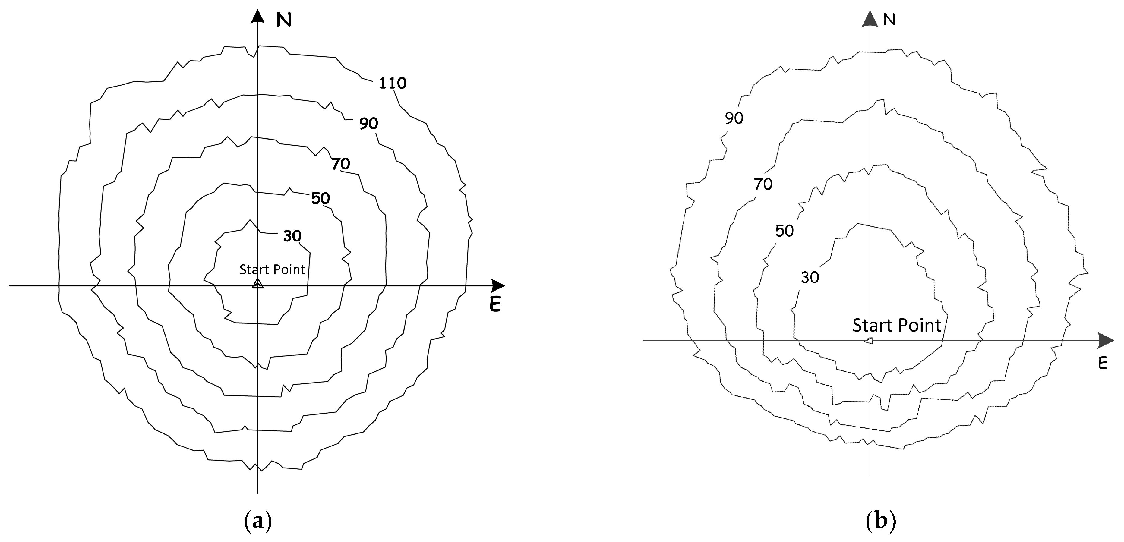
4.1. Homogeneous Grassland

A wildfire in a homogeneous area was simulated with no wind, flat ground, and a uniform fuel bed. In this sense, the flammability was uniform throughout the testing space, resulting in the same fire spread rate in all directions. Figure 8 shows the simulation results of the fire boundaries at 30t, 50t, 70t, and 90t (t is one time step) under the aforementioned conditions. This indicates that the simulated grassland wildfires proliferated equidistantly from the fire starting point. Figure 9 shows the corresponding linear increase in fire spreading speed during the simulation.

4.2. Non-Combustible Obstacles

A wildfire in an area with non-combustible obstacles, such as large rocks and pools, was simulated. In this situation, the flammability of the fuel bed is disturbed by obstacles. Figure 10 shows the simulation results under these conditions. Generally, the simulated fire still proliferates equidistantly from the circle center, but the shape of the fire fronts is twisted because of the non-combustible obstacles. The decay of the fire spread can also be observed in the direction of the obstruction. However, after the fire front crosses the obstacles, the boundary groove can be rapidly restored, gradually reshaping the fire boundaries into general circles again.
Disturbances can also be determined based on the fire spread rate. Figure 11 presents the overall differences in the burning area (BAD) and fire spread speed (SSD) in a homogeneous situation between those with and without non-combustible obstacles. As shown in the figure, after a small-scale fluctuation in its early stage, the fire with a non-combustible obstacle was hampered at 50t when it encountered obstacles, and reached its peak at 70t (the time when the fire front was just across the obstacles). However, after 70t, as the groove quickly filled, the SSD began to decrease until a stable value was attained.

4.3. Heterogeneous Grassland

In practice, heterogeneous grasslands are much more common, and the flammability of fuel beds varies from place to place. Figure 12 shows the simulation results of the fire fronts under two different conditions: one with an easily flammable fuel, and the other with a harder fuel. The fire fronts still proliferated equidistantly in each fuel bed type from the fire start point, but with different spreading speeds. The fire spreading speed in areas with harder flammable species was significantly slower than that in areas with easily flammable species. Figure 13 illustrates the differences of the burning area (BA) and spreading speed (SS) in three types of species: hard-flammable (-H), normal (-N), and easily flammable (-E).
This situation can also be illustrated by the proportion of fully developed burning cells among all burning cells in the fire front during fire spread. The proportion of fully developed burning cells was extremely sensitive to different fuels, as shown in Figure 14. The more easily the species tends to combust, the lower is the proportion of fully developed burning cells, which implies that hard-flammable fuels require more time to ignite.

4.4. Wind Factor

In the absence of wind, fire proliferates equidistantly from the center of the circle, which is the fire point, to the surroundings, and the local details tend to rule out randomness. Assuming that the fire broke out in homogeneous grassland (i.e., the flammability factor is the same everywhere in the area), under the same conditions as the previous simulation but introducing the wind factor, the fire spread morphology is affected by the wind factor, which means that the forest fire spread accelerated in the direction of the wind and slowed in the opposite direction. Figure 15 simulates the spread morphology of forest fire when the wind speed from the south is weak and when it is slightly stronger, respectively; it can be seen that the proliferation of fire morphology is similarly close to circular when wind speed is weak (Figure 15a), similar to when there is no wind, and with increased wind speed (Figure 15b), the fire spread accelerates markedly northward and is inhibited southward, leading to an elliptical fire proliferation area.

4.5. Topographic Factors

Assuming that the fire breaks out in an area with no wind, a single species, uniform density (i.e., the flammability factor is the same everywhere in this area), and undulating topography, the fire spread rate is affected by topographic factors in all directions. Topographic factors often cause grassland fires to spread rapidly uphill and slowly downhill, resulting in the deformation and evolution of the fire line shape with the terrain. Figure 16 shows the simulation results for forest fire spread as affected by terrain factors. The start point of the fire was located at the foot of the mountain, and the proliferation of the fire line was still elliptical in shape in the front because of its flat terrain, but was deformed from behind because it was against the hillside from behind. It can be seen from the figure that the fire spread faster uphill than on flat ground.

5. Conclusions

This study presents a novel method for evaluating the dynamics of grassland wildfire spread based on cellular automata, specifically for Inner Mongolian grassland wildfires. It emphasizes a variety of factors, especially meteorological variables, including wind, relative humidity, daily precipitation, and daily maximum temperature. Due to the rapid occurrence and development of grassland wildfires, practical fire management requires spread models to respond quickly. This method utilizes meteorological data to simplify the model while meeting accuracy requirements, ensuring that the model can provide decision support for practical fire simulations.
Several tests, including one real-world case and three hypothetical forests, were conducted to verify the effectiveness of the model. The simulation results suggest good agreement between the model and real-world experiences, which can facilitate real-time decision-making to enhance the effectiveness of firefighting, fire control, and simulation-based training for firefighters. In the actual case, the accuracy comparison utilized only remote sensing images of the post-fire footprint. There is a lack of data to verify the accuracy of the fire line position during the firefighting process. The spatial resolution of geostationary positioning is insufficient to satisfy these requirements. The next step is to use drones or manned aircraft for image data collection and verification.
For future wildfire spread prediction, further research should be conducted on the deep mechanism and simulation methods, such as the formation mechanism of the local microclimate in the fire field and associated modeling methods, as well as the performance of firebreaks. In this study, a supervised classification approach was employed to categorize the vegetation types within the study area, with each category corresponding to a fixed model parameter. Vegetation indices such as NDVI and vegetation parameters such as surface biomass exhibit a high degree of correlation and can be introduced as variables in a crop model. A more effective approach would be to integrate the work of others in quantitatively estimating fuel load and fuel moisture, using remote sensing retrieval results as model parameters, which is also our next step in the research. The findings of these studies provide more scientific and comprehensive decision support for intelligent emergency command in cases of grassland wildfire.
In summary, the model established through this study of fire behavior mechanisms allows for relatively rapid and accurate simulations of Mongolian grasslands. Compared with other fire behavior models, it has fewer parameters and a simpler model structure, while still meeting the required accuracy. By integrating numerical weather forecast results, this transition from basic weather forecasting to fire behavior prediction during actual firefighting enhances the alignment with firefighting requirements and provides more precise predictions.

Author Contributions

Conceptualization, Yan Li, Manchun Li, and Zhenjie Chen; methodology, Yan Li, Guozhou Wu, and Shuai Zhang; software, Yan Li and Shuai Zhang; validation, Yan Li and Guozhou Wu; formal analysis, Yan Li, Guozhou Wu, Manchun Li, and Zhenjie Chen; investigation, Yan Li, Manchun Li, and Zhenjie Chen; resources, Yan Li, Guozhou Wu and Shuai Zhang; data curation, Yan Li and Beidou Nie; writing—original draft preparation, Yan Li and Shuai Zhang; writing—review and editing, Yan Li and Guozhou Wu; visualization, Yan Li, and Beidou Nie; supervision, Guozhou Wu, Shuai Zhang, Manchun Li, Beidou Nie, and Zhenjie Chen. All authors have read and agreed to the published version of the manuscript.

Funding

This research was funded by the National Natural Science Foundation of China (grant number 42230113).

Data Availability Statement

The data are contained within the article and all data sources are mentioned. The data used during the study are available from the corresponding author by request.

Conflicts of Interest

Author Shuai Zhang was employed by the company Nanjing Retinar Information Technology Co. The remaining authors declare that the research was conducted in the absence of any commercial or financial relationships that could be construed as a potential conflict of interest.

References

  1. Sommers, W.T.; Loehman, R.A.; Hardy, C.C. Wildland fire emissions, carbon, and climate: Science overview and knowledge needs. For. Ecol. Manag. 2014, 317, 1–8. [Google Scholar] [CrossRef]
  2. Liu, Z.; Ballantyne, A.P.; Cooper, L.A. Biophysical feedback of global forest fires on surface temperature. Nat. Commun. 2019, 10, 214. [Google Scholar] [CrossRef]
  3. Pausas, J.G.; Keeley, J.E. Wildfires as an ecosystem service. Front. Ecol. Environ. 2019, 17, 289–295. [Google Scholar] [CrossRef]
  4. Barboza Castillo, E.; Turpo Cayo, E.Y.; de Almeida, C.M.; Salas López, R.; Rojas Briceño, N.B.; Silva López, J.O.; Barrena Gurbillón, M.Á.; Oliva, M.; Espinoza-Villar, R. Monitoring Wildfires in the Northeastern Peruvian Amazon Using Landsat-8 and Sentinel-2 Imagery in the GEE Platform. ISPRS Int. J. Geo-Inf. 2020, 9, 564. [Google Scholar] [CrossRef]
  5. Bar Massada, A.; Radeloff, V.C.; Stewart, S.I.; Hawbaker, T.J. Wildfire risk in the wildland–urban interface: A simulation study in northwestern Wisconsin. For. Ecol. Manag. 2009, 258, 1990–1999. [Google Scholar] [CrossRef]
  6. Haas, J.R.; Calkin, D.E.; Thompson, M.P. A national approach for integrating wildfire simulation modeling into Wildland Urban Interface risk assessments within the United States. Landsc. Urban Plan. 2013, 119, 44–53. [Google Scholar] [CrossRef]
  7. Dupuy, J.-L.; Fargeon, H.; Martin-Stpaul, N.; Pimont, F.; Ruffault, J.; Guijarro, M.; Hernando, C.; Madrigal, J.; Fernandes, P. Climate change impact on future wildfire danger and activity in southern Europe: A review. Ann. For. Sci. 2020, 77, 35. [Google Scholar] [CrossRef]
  8. Wei, C.; Xu, J.; Li, Q.; Jiang, S. An Intelligent Wildfire Detection Approach through Cameras Based on Deep Learning. Sustainability 2022, 14, 15690. [Google Scholar] [CrossRef]
  9. Kalogiannidis, S.; Chatzitheodoridis, F.; Kalfas, D.; Patitsa, C.; Papagrigoriou, A. Socio-Psychological, Economic and Environmental Effects of Forest Fires. Fire 2023, 6, 280. [Google Scholar] [CrossRef]
  10. Tian, X.; Zhao, F.; Shu, L.; Wang, M. Distribution characteristics and the influence factors of forest fires in China. For. Ecol. Manag. 2013, 310, 460–467. [Google Scholar] [CrossRef]
  11. Li, L.; Zha, Y. Mapping relative humidity, average and extreme temperature in hot summer over China. Sci. Total Environ. 2017, 615, 875–881. [Google Scholar] [CrossRef]
  12. Daily, P.S. The Greatest Forest Fire in the Greater Khingan Range, Footprints of the Great Nation. 1987. Available online: https://en.m.wikipedia.org/wiki/1987_Black_Dragon_fire (accessed on 5 February 2017).
  13. Rothermel, R.C. A Mathematical Model for Predicting Fire Spread in Wildland Fuels; Intermountain Forest & Range Experiment Station, Forest Service, US Department of Agriculture: Ogden, UT, USA, 1972; Volume 115. [Google Scholar]
  14. Catchpole, T.; de Mestre, N. Physical models for a spreading line fire. Aust. For. 1986, 49, 102–111. [Google Scholar] [CrossRef]
  15. Weber, R.O. Modelling fire spread through fuel beds. Prog. Energy Combust. Sci. 1991, 17, 67–82. [Google Scholar] [CrossRef]
  16. Weber, R.O. Toward a comprehensive wildfire spread model. Int. J. Wildland Fire 1991, 1, 245–248. [Google Scholar] [CrossRef]
  17. Ntaimo, L.; Hu, X.; Sun, Y. DEVS-FIRE: Towards an integrated simulation environment for surface wildfire spread and containment. Simulation 2008, 84, 137–155. [Google Scholar] [CrossRef]
  18. Moritz, M.A.; Batllori, E.; Bradstock, R.A.; Gill, A.M.; Handmer, J.; Hessburg, P.F.; Leonard, J.; McCaffrey, S.; Odion, D.C.; Schoennagel, T.; et al. Learning to coexist with wildfire. Nature 2014, 515, 58–66. [Google Scholar] [CrossRef]
  19. Cascio, W.E. Wildland fire smoke and human health. Sci. Total Environ. 2018, 624, 586–595. [Google Scholar] [CrossRef]
  20. Coogan, S.C.P.; Robinne, F.-N.; Jain, P.; Flannigan, M.D. Scientists’ warning on wildfire—A Canadian perspective. Can. J. For. Res. 2019, 49, 1015–1023. [Google Scholar] [CrossRef]
  21. Abatzoglou, J.T.; Williams, A.P. Impact of anthropogenic climate change on wildfire across western US forests. Proc. Natl. Acad. Sci. USA 2016, 113, 11770–11775. [Google Scholar] [CrossRef]
  22. Nur, A.S.; Kim, Y.J.; Lee, J.H.; Lee, C.W. Spatial Prediction of Wildfire Susceptibility Using Hybrid Machine Learning Models Based on Support Vector Regression in Sydney, Australia. Remote Sens. 2023, 15, 760. [Google Scholar] [CrossRef]
  23. Jolly, W.M.; Cochrane, M.A.; Freeborn, P.H.; Holden, Z.A.; Brown, T.J.; Williamson, G.J.; Bowman, D. Climate-induced variations in global wildfire danger from 1979 to 2013. Nat. Commun. 2015, 6, 7537. [Google Scholar] [CrossRef]
  24. Westerling, A.L. Increasing western US forest wildfire activity: Sensitivity to changes in the timing of spring. Philos. Trans. R. Soc. B Biol. Sci. 2016, 371, 20150178. [Google Scholar] [CrossRef]
  25. Williams, A.P.; Abatzoglou, J.T.; Gershunov, A.; Guzman-Morales, J.; Bishop, D.A.; Balch, J.K.; Lettenmaier, D.P. Observed Impacts of Anthropogenic Climate Change on Wildfire in California. Earth’s Future 2019, 7, 892–910. [Google Scholar] [CrossRef]
  26. Countryman, C.M. The fire environment concept-Pacific Southwest Forest and Range Experiment Station. The Fire Environment Concept; USDA Forest Service: Berkeley, CA, USA, 1972. [Google Scholar]
  27. Jain, P.; Coogan, S.C.P.; Subramanian, S.G.; Crowley, M.; Taylor, S.; Flannigan, M.D. A review of machine learning applications in wildfire science and management. Environ. Rev. 2020, 28, 478–505. [Google Scholar] [CrossRef]
  28. He, W.; Shirowzhan, S.; Pettit, C.J. GIS and Machine Learning for Analysing Influencing Factors of Bushfires Using 40-Year Spatio-Temporal Bushfire Data. ISPRS Int. J. Geo-Inf. 2022, 11, 336. [Google Scholar] [CrossRef]
  29. Pastor, E.; Zárate, L.; Planas, E.; Arnaldos, J. Mathematical models and calculation systems for the study of wildland fire behaviour. Prog. Energy Combust. Sci. 2003, 29, 139–153. [Google Scholar] [CrossRef]
  30. Finney, M. FARSITE: Fire Area Simulator—Model Development and Evaluation; USDA Forest Service—Research Papers RMRS; U.S. Department of Agriculture, Forest Service, Rocky Mountain Research Station: Ogden, UT, USA, 1998. [Google Scholar]
  31. Andrews, P. BEHAVE: Fire Behavior Prediction and Fuel Modeling System-BURN Subsystem, Part 1: The Bark Beetles, Fuels, and Fire Bibliography; US Department of Agriculture, Forest Service, Intermountain Research Station: Ogden, UT, USA, 1986. [Google Scholar]
  32. Stocks, B.; Lynham, T.J.; Lawson, B.; Alexander, M.; Wagner, C.; McAlpine, R.S.; Dubé, D.E. The Canadian Forest Fire Danger Rating System. For. Chron. 1989, 65, 258–265. [Google Scholar] [CrossRef]
  33. Tymstra, C.; Bryce, R.W.; Wotton, B.M.; Taylor, S.W.; Armitage, O.B. Development and Structure of Prometheus: The Canadian Wildland Fire Growth Simulation Model; Information Report NOR-X-417; Natural Resources Canada, Canadian Forest Service, Northern Forestry Centre: Edmonton, AB, Canada, 2010. [Google Scholar]
  34. Coleman, J.R.; Sullivan, A.L. A real-time computer application for the prediction of fire spread across the Australian landscape. Simulation 1996, 67, 230–240. [Google Scholar] [CrossRef]
  35. Chandler, C.; Cheney, P.; Thomas, P.; Trabaud, L.; Williams, D. Fire in Forestry. Volume 1. Forest Fire Behavior and Effects. Volume 2. Forest Fire Management and Organization; John Wiley & Sons, Inc.: Hoboken, NJ, USA, 1983. [Google Scholar]
  36. Beer, T. The interaction of wind and fire. Bound.-Layer Meteorol. 1991, 54, 287–308. [Google Scholar] [CrossRef]
  37. Alexander, M.E.; Cruz, M.G. Limitations on the accuracy of model predictions of wildland fire behaviour: A state-of-the-knowledge overview. For. Chron. 2013, 89, 372–383. [Google Scholar] [CrossRef]
  38. Bakhshaii, A.; Johnson, E.A. A review of a new generation of wildfire–atmosphere modeling. Can. J. For. Res. 2019, 49, 565–574. [Google Scholar] [CrossRef]
  39. Bailon-Ruiz, R.; Bit-Monnot, A.; Lacroix, S. Real-time wildfire monitoring with a fleet of UAVs. Robot. Auton. Syst. 2022, 152, 104071. [Google Scholar] [CrossRef]
  40. Tarifa, C.; Torralbo, A. Flame propagation along the interface between a gas and a reacting medium. Symp. (Int.) Combust. 1967, 11, 533–544. [Google Scholar] [CrossRef]
  41. Williams, F.A. Mechanisms of fire spread. Symp. (Int.) Combust. 1977, 16, 1281–1294. [Google Scholar] [CrossRef]
  42. Gale, M.G.; Cary, G.J.; Van Dijk, A.I.J.M.; Yebra, M. Forest fire fuel through the lens of remote sensing: Review of approaches, challenges and future directions in the remote sensing of biotic determinants of fire behaviour. Remote Sens. Environ. 2021, 255, 112282. [Google Scholar] [CrossRef]
  43. Athanasiou, M.; Martinis, A.; Korakaki, E.; Avramidou, E.V. Development of a Fuel Model for Cistus spp. and Testing Its Fire Behavior Prediction Performance. Fire 2023, 6, 247. [Google Scholar] [CrossRef]
  44. Balbi, J.H.; Morandini, F.; Silvani, X.; Filippi, J.B.; Rinieri, F. A physical model for wildland fires. Combust. Flame 2009, 156, 2217–2230. [Google Scholar] [CrossRef]
  45. Chatelon, J.; Balbi, J.; Cruz, M.; Morvan, D.; Rossi, J.-L.; Carmen, A.; Frangieh, N.; Fayad, J.; Marcelli, T. Extension of the Balbi fire spread model to include the field scale conditions of shrubland fires. Int. J. Wildland Fire 2022, 31, 176–192. [Google Scholar] [CrossRef]
  46. McArthur, A.G. Prescribed burning in Australian fire control. Aust. For. 1966, 30, 4–11. [Google Scholar] [CrossRef]
  47. Luke, R.H.; McArthur, A.G. Bushfires in Australia; Australian Government Publishing Service for CSIRO: Black Mountain, Australia, 1978. [Google Scholar]
  48. Yassemi, S.; Dragićević, S.; Schmidt, M. Design and implementation of an integrated GIS-based cellular automata model to characterize forest fire behaviour. Ecol. Model. 2008, 210, 71–84. [Google Scholar] [CrossRef]
  49. Sullivan, A. Wildland surface fire spread modelling, 1990–2007. 2: Empirical and quasi-empirical models. Int. J. Wildland Fire 2009, 18, 369–386. [Google Scholar] [CrossRef]
  50. Kolaitis, D.I.; Pallikarakis, C.; Founti, M.A. Comparative Assessment of Wildland Fire Rate of Spread Models: Effects of Wind Velocity. Fire 2023, 6, 188. [Google Scholar] [CrossRef]
  51. Moody, J.A.; Shakesby, R.A.; Robichaud, P.R.; Cannon, S.H.; Martin, D.A. Current research issues related to post-wildfire runoff and erosion processes. Earth-Sci. Rev. 2013, 122, 10–37. [Google Scholar] [CrossRef]
  52. Sullivan, A. Wildland surface fire spread modelling, 1990–2007. 1: Physical and quasi-physical models. Int. J. Wildland Fire 2009, 18, 349–368. [Google Scholar] [CrossRef]
  53. McLauchlan, K.K.; Higuera, P.E.; Miesel, J.; Rogers, B.M.; Schweitzer, J.; Shuman, J.K.; Tepley, A.J.; Varner, J.M.; Veblen, T.T.; Adalsteinsson, S.A.; et al. Fire as a fundamental ecological process: Research advances and frontiers. J. Ecol. 2020, 108, 2047–2069. [Google Scholar] [CrossRef]
  54. Liu, X.-P.; Tong, Z.-J.; Zhang, J.-Q.; Song, C.-T. Uncertainty simulation of large-scale discrete grassland fire spread based on Monte Carlo. Fire Saf. J. 2023, 135, 103713. [Google Scholar] [CrossRef]
  55. Albini, F.A. A Model for Fire Spread in Wildland Fuels by-Radiation. Combust. Sci. Technol. 1985, 42, 229–258. [Google Scholar] [CrossRef]
  56. Deeming, J.E.; Burgan, R.E.; Cohen, J.D. The National Fire-Danger Rating System—1978; Intermountain Forest and Range Experiment Station, Forest Service, US Department of Agriculture: Ogden, UT, USA, 1977; Volume 39. [Google Scholar]
  57. Minsavage-Davis, C.; Davies, G. Evaluating the Performance of Fire Rate of Spread Models in Northern-European Calluna vulgaris Heathlands. Fire 2022, 5, 46. [Google Scholar] [CrossRef]
  58. Tang, X.; Meng, X.; Yi, H. Review and prospect of researches on forest fire spreading models and simulation method. J. Beijing For. Univ. 2002, 24, 87–91. [Google Scholar]
  59. Wu, Z.; He, H.; Chang, Y.; Liu, Z.; Chen, H. Development of Customized Fire Behavior Fuel Models for Boreal Forests of Northeastern China. Environ. Manag. 2013, 48, 1148–1157. [Google Scholar] [CrossRef]
  60. Toffoli, T.; Margolus, N. Cellular Automata Machines: A New Environment for Modeling; MIT Press: Cambridge, MA, USA, 1987; p. 259. [Google Scholar]
  61. Wolfram, S. A New Kind of Science; Wolfram Media: Champaign, IL, USA, 2002. [Google Scholar]
  62. Reiter, C.A. A local cellular model for snow crystal growth. Chaos Solitons Fractals 2005, 23, 1111–1119. [Google Scholar] [CrossRef]
  63. Kelly, J.G.; Boyer, E.C. Physical Improvements to a Mesoscopic Cellular Automaton Model for Three-Dimensional Snow Crystal Growth. Cryst. Growth Des. 2014, 14, 1392–1405. [Google Scholar] [CrossRef]
  64. Xu, X.Y.; Wang, W. Nonisothermal cellular automata simulation of two-dimensional snow crystal growth. Phys. Rev. E 2022, 106, 055309. [Google Scholar] [CrossRef]
  65. Batty, M.; Xie, Y.; Sun, Z. Modeling urban dynamics through GIS-based cellular automata. Comput. Environ. Urban Syst. 1999, 23, 205–233. [Google Scholar] [CrossRef]
  66. Esser, J.; Schreckenberg, M. Microscopic Simulation of Urban Traffic Based On Cellular Automata. Int. J. Mod. Phys. C 1997, 8, 1025–1036. [Google Scholar] [CrossRef]
  67. White, R.; Engelen, G.; Uljee, I. The Use of Constrained Cellular Automata for High-Resolution Modelling of Urban Land-Use Dynamics. Environ. Plan. B: Plan. Des. 1997, 24, 323–343. [Google Scholar] [CrossRef]
  68. Abolhasani, S.; Taleai, M. Assessing the effect of temporal dynamics on urban growth simulation: Towards an asynchronous cellular automata. Trans. GIS 2020, 2020, 332–354. [Google Scholar] [CrossRef]
  69. Langton, C.G. Self-reproduction in cellular automata. Phys. D Nonlinear Phenom. 1984, 10, 135–144. [Google Scholar] [CrossRef]
  70. Rosin, P.L. Training cellular automata for image processing. IEEE Trans. Image Process. 2006, 15, 2076–2087. [Google Scholar] [CrossRef]
  71. Yang, Y.-G.; Tian, J.; Lei, H.; Zhou, Y.-H.; Shi, W.-M. Novel quantum image encryption using one-dimensional quantum cellular automata. Inf. Sci. 2016, 345, 257–270. [Google Scholar] [CrossRef]
  72. Sirakoulis, G.C.; Karafyllidis, I.; Thanailakis, A. A cellular automaton model for the effects of population movement and vaccination on epidemic propagation. Ecol. Model. 2000, 133, 209–223. [Google Scholar] [CrossRef]
  73. Achtemeier, G. Field validation of a free-agent cellular automata model of fire spread with fire—Atmosphere coupling. Int. J. Wildland Fire 2013, 22, 148. [Google Scholar] [CrossRef]
  74. Alexandridis, A.; Vakalis, D.; Siettos, C.I.; Bafas, G.V. A cellular automata model for forest fire spread prediction: The case of the wildfire that swept through Spetses Island in 1990. Appl. Math. Comput. 2008, 204, 191–201. [Google Scholar] [CrossRef]
  75. Hernández Encinas, A.; Hernández Encinas, L.; Hoya White, S.; Martín del Rey, A.; Rodríguez Sánchez, G. Simulation of forest fire fronts using cellular automata. Adv. Eng. Softw. 2007, 38, 372–378. [Google Scholar] [CrossRef]
  76. Hernández Encinas, L.; Hoya White, S.; Martín del Rey, A.; Rodríguez Sánchez, G. Modelling forest fire spread using hexagonal cellular automata. Appl. Math. Model. 2007, 31, 1213–1227. [Google Scholar] [CrossRef]
  77. Karafyllidis, I.; Thanailakis, A. A model for predicting forest fire spreading using cellular automata. Ecol. Model. 1997, 99, 87–97. [Google Scholar] [CrossRef]
  78. Soares-Filho, B.S.; Coutinho Cerqueira, G.; Lopes Pennachin, C. dinamica—A stochastic cellular automata model designed to simulate the landscape dynamics in an Amazonian colonization frontier. Ecol. Model. 2002, 154, 217–235. [Google Scholar] [CrossRef]
  79. Jellouli, O.; Bernoussi, A.; Mâatouk, M.; Amharref, M. Forest fire modelling using cellular automata: Application to the watershed Oued Laou (Morocco). Math. Comput. Model. Dyn. Syst. 2016, 22, 493–507. [Google Scholar] [CrossRef]
  80. Zhou, G.; Wu, Q.; Chen, A. Forestry Fire Spatial Diffusion Model Based on Multi-Agent Algorithm with Cellular Automata. Xitong Fangzhen Xuebao/J. Syst. Simul. 2018, 30, 824–830. [Google Scholar] [CrossRef]
  81. Trucchia, A.; D’Andrea, M.; Baghino, F.; Fiorucci, P.; Ferraris, L.; Negro, D.; Gollini, A.; Severino, M. PROPAGATOR: An Operational Cellular-Automata Based Wildfire Simulator. Fire 2020, 3, 26. [Google Scholar] [CrossRef]
  82. Li, X.; Zhang, M.; Zhang, S.; Liu, J.; Sun, S.; Hu, T.; Sun, L. Simulating Forest Fire Spread with Cellular Automation Driven by a LSTM Based Speed Model. Fire 2022, 5, 13. [Google Scholar] [CrossRef]
  83. Wang, X.; Luan, D. A novel image encryption algorithm using chaos and reversible cellular automata. Commun. Nonlinear Sci. Numer. Simul. 2013, 18, 3075–3085. [Google Scholar] [CrossRef]
  84. Karlsson, B. The Burning Process and Enclosure Fires, Plastics Flammability Handbook; Hanser Publishers: Munich, Germany, 2013; pp. 33–46. [Google Scholar]
  85. Peng, S.; Wang, G.; Yu, S. Modeling the dynamics of worm propagation using two-dimensional cellular automata in smartphones. J. Comput. Syst. Sci. 2013, 79, 586–595. [Google Scholar] [CrossRef]
  86. Xanthopoulos, G.; Calfapietra, C.; Fernandes, P. Fire Hazard and Flammability of European Forest Types. In Post-Fire Management and Restoration of Southern European Forests; Springer: Dordrecht, The Netherlands, 2012; Volume 24, pp. 79–92. [Google Scholar]
  87. Anderson, H. Forest fuel ignitibility. Fire Technol. 1970, 6, 312–319. [Google Scholar] [CrossRef]
  88. Dimitrakopoulos, A.; Papaioannou, K. Flammability Assessment of Mediterranean Forest Fuels. Fire Technol. 2001, 37, 143–152. [Google Scholar] [CrossRef]
  89. Williams, R.; Cook, G.; Gill, A.; Moore, P. Fire regime, fire intensity and tree survival in a tropical savanna in Northern Australia. Aust. J. Ecol. 1999, 24, 50–59. [Google Scholar] [CrossRef]
  90. Coskuner, K. Land use/land cover change as a major driver of current landscape flammability in Eastern Mediterranean region: A case study in Southwestern Turkey. Bosque 2022, 43, 157–167. [Google Scholar] [CrossRef]
  91. Kganyago, M.; Shikwambana, L. Assessment of the Characteristics of Recent Major Wildfires in the USA, Australia and Brazil in 2018-2019 Using Multi-Source Satellite Products. Remote Sens. 2020, 12, 1803. [Google Scholar] [CrossRef]
  92. Cui, L.; Zhang, J.; Bao, Y.; Tong, Z.; Liu, X. A study on early warning of grassland fire disaster risk in Hulunbeier. Acta Prataculturae Sin. 2012, 21, 282–292. [Google Scholar]
  93. Hu, H. Experiments and analysis on forest fuel physicochemical characteristics in the Greater Khingan Range. For. Fire Prev. 1995, 1, 27. [Google Scholar]
  94. Madrigal, J.; Hernando, C.; Guijarro, M.; Díez, C.; Marino, E.; de Castro, A. Evaluation of Forest Fuel Flammability and Combustion Properties with an Adapted Mass Loss Calorimeter Device. J. Fire Sci. 2009, 27, 323–342. [Google Scholar] [CrossRef]
  95. Abatzoglou, J.T.; Kolden, C.A.; Williams, A.P.; Sadegh, M.; Balch, J.K.; Hall, A. Downslope Wind-Driven Fires in the Western United States. Earth’s Future 2023, 11, e2022EF003471. [Google Scholar] [CrossRef]
  96. Weise, D.R.; Biging, G.S. Effects of wind velocity and slope on flame properties. Can. J. For. Res. 1996, 26, 1849–1858. [Google Scholar] [CrossRef]
  97. Alexandridis, A.; Russo, L.; Vakalis, D.; Bafas, G.V.; Siettos, C.I. Wildland fire spread modelling using cellular automata: Evolution in large-scale spatially heterogeneous environments under fire suppression tactics. Int. J. Wildland Fire 2011, 20, 633–647. [Google Scholar] [CrossRef]
  98. Carmo, M.; Moreira, F.; Casimiro, P.; Vaz, P. Land use and topography influences on wildfire occurrence in northern Portugal. Landsc. Urban Plan. 2011, 100, 169–176. [Google Scholar] [CrossRef]
  99. Jiang, W.; Wang, F.; Su, G.; Li, X.; Wang, G.; Zheng, X.; Wang, T.; Meng, Q. Modeling Wildfire Spread with an Irregular Graph Network. Fire 2022, 5, 185. [Google Scholar] [CrossRef]
Figure 1. Growth phase of a typical fire dynamic.
Ijgi 12 00474 g001
Figure 2. Moore Neighborhood.
Ijgi 12 00474 g002
Figure 3. Location map of the study area. (a) China’s location; (b) the position of Xilingol League in Inner Mongolia; (c) fire location.
Ijgi 12 00474 g003
Figure 4. Remote sensing images of the study area before and after the fire. (a) Remote sensing image before the fire (19 October 2021); (b) remote sensing image after the fire (1 November 2021).
Ijgi 12 00474 g004
Figure 5. Geographic data of the fire field. (a) Topographic elevation of the fire field; (b) vegetation type map.
Ijgi 12 00474 g005
Figure 6. Meteorological data of the fire field. (a) Wind speed and direction; (b) temperature and relative humidity.
Ijgi 12 00474 g006
Figure 7. Grassland wildfire spread simulation. (a) Simulation results at 14:00; (b) simulation results at 19:00; (c) simulation results at 24:00; (d) fire spread simulation statistics.
Ijgi 12 00474 g007aIjgi 12 00474 g007b
Figure 8. Fire fronts in a homogeneous situation without any wind or topographic effects. The fire starts at the center of the circular fronts, which were captured at time steps 30, 50, 70, and 90.
Ijgi 12 00474 g008
Figure 9. Burning area and fire spreading speed in a homogeneous situation (Unit: Cell).
Ijgi 12 00474 g009
Figure 10. Homogeneous fire fronts with a non-combustible obstacle.
Ijgi 12 00474 g010
Figure 11. Differences of BAD and SSD in a homogeneous situation between those with and without a non-combustible obstacle.
Ijgi 12 00474 g011
Figure 12. Fire fronts in hard-flammable and easily flammable species.
Ijgi 12 00474 g012
Figure 13. Burning area (BA) and fire spreading speed (SS) in hard-flammable (-H), normal (-N), and easily flammable (-E) species.
Ijgi 12 00474 g013
Figure 14. Proportion of fully developed cells in three types of fuels: hard-flammable (H-), normal (N-), and easily flammable (E-).
Ijgi 12 00474 g014
Figure 15. Successive fire fronts in a flat homogeneous grassland when: (a) a weak wind and (b) a stronger wind is blowing.
Ijgi 12 00474 g015
Figure 16. Successive fire fronts in a homogeneous forest with a hill or a mountain in it when no wind blows.
Ijgi 12 00474 g016
Table 1. Grass species classification values [84].
ClassificationGrassland Types
4Bunch grass and mowing
3Salt meadow, grass, and mowing
2Grass, carex, and forbs meadow; rhizomatous grasses, forbs meadow, and grazing
1Grass, carex, mixed broad-leaved forest grasses, pioneer plant grasses, shrub, deciduous broadleaved forest grasses, grazing, meadow grass, weeds, etc.
Table 2. Fire front intensity in different fire growth phases.
State (S)Intensity (I)
0, 40.00
10.48
20.85
0, 40.00
Disclaimer/Publisher’s Note: The statements, opinions and data contained in all publications are solely those of the individual author(s) and contributor(s) and not of MDPI and/or the editor(s). MDPI and/or the editor(s) disclaim responsibility for any injury to people or property resulting from any ideas, methods, instructions or products referred to in the content.

