
Spatial Morphological Characteristics and Evolution of Traditional Villages in the Mountainous Area of Southwest Zhejiang
1
School of Landscape Architecture and Architecture, Zhejiang Agriculture and Forestry University, Hangzhou 311300, China
2
Beijing Zhongnong Futong Horticulture Co., Ltd., Beijing 100083, China
*
Author to whom correspondence should be addressed.
†
These authors contributed equally to this work.
ISPRS Int. J. Geo-Inf. 2023, 12(8), 317; https://doi.org/10.3390/ijgi12080317
Submission received: 24 March 2023
/
Revised: 9 July 2023
/
Accepted: 29 July 2023
/
Published: 1 August 2023
Abstract
:National-level traditional villages in Liandu District and Qingyuan County, Lishui City, in the southwestern mountainous area of Zhejiang Province serve as research objects in our exploration of the external representation and deep spatial structure changes in traditional village spatial forms from a synchronic and diachronic perspective. We use morphological indices, space syntax, city image surveys, and other analysis methods to reveal the formation and evolution of these forms. We find that: (1) Traditional village boundaries in the mountainous area of southwest Zhejiang are mainly clusters and bands, which are restricted by geographical conditions and tend to expand in the direction of rivers and roads. (2) The original spatial forms of settlements effectively organize the travel activities of local residents and external visitors, while the corresponding two fabric centers basically coincide. However, with the continuous evolution of settlements and the intervention of modern construction projects, the centers have shifted slightly. (3) Factors such as the natural environment, clan consanguinity, and economic and technological conditions jointly act on spatial forms manifesting as “stability maintenance” and “sudden change” games; thus, the forms show overlapping and integration across multiple temporal and spatial points.
1. Introduction
In 2013, the No. 1 document of the Central Committee pointed out that special plans should be formulated and special projects launched to strengthen the protection of traditional villages and dwellings with historical and cultural value and ethnic and regional elements. In 2017, the General Office of the CPC Central Committee and the General Office of the State Council issued the Opinions on Implementing the Project of Inheriting and Developing Excellent Chinese Traditional Culture, proposing to implement the Project of Protecting Chinese Traditional Villages, and the protection of traditional villages entered a new stage. In 2021, the central No. 1 document clearly proposed to “strengthen the guidance of village style, protect traditional villages, traditional dwellings and historical and cultural villages and towns”. The protection and management of traditional villages in China are constantly increasing. The successive promulgation of relevant policies has provided important guidance for the protection and development of traditional villages, and various protection works and research have continued to be carried out.
Traditional villages inherit their historical context and are an important resource and potential driving force for rural revitalization in the modern era [1]. Their value is not limited to single buildings or intangible cultural elements but is also inextricable from the spatial form that reflects human adaptation to nature and the wisdom of ancient people. Settlements in the mountainous area of southwest Zhejiang, for example, have gradually formed unique street spaces, patterns, and textures over their lengthy histories. Today, these forms reflect a harmonious, symbiotic relationship between humans and the natural environment. This relationship is guided by the water resources of nearby mountains and other ecological effects.
The continuous advancements in construction practices have increased the depth and breadth of city-planning-related interventions in traditional village spaces. Traditional villages are impacted by rapid urbanization; strong conflicts emerge between the protection of original patterns and cultural sites and modernization and new construction. Traditional patterns and textures can be seriously damaged when villages modernize [2]. It is crucial to effectively analyze the types, characteristics, and evolution processes of traditional villages to protect them from the harmful effects of modernization while preserving their spatial forms effectively.
The field of traditional village spatial research has attracted wide attention. From the perspective of research themes, it mainly focuses on three aspects: the summary of spatial-form-type characteristics, the mining of evolution rules, and the form protection strategy, among which the research on the form protection development strategy is based on the previous two [3,4,5,6]. From the perspective of research, current research mainly focuses on human geography, landscape ecology, architecture, planning, and other fields, and the research perspectives, research scales, and emphases of each discipline are different, showing a trend of interdisciplinary integration on the whole [7,8,9,10,11,12,13,14].
From the perspective of research methods, research on village spatial evolution mainly focuses on qualitative analysis methods such as survey interviews and data collation, and few use multi-disciplinary analysis methods such as rational sociology [15,16,17,18]. However, with the development of computer technology, the application of quantitative analysis methods shows an increasing trend, and the future trend of village settlement spatial form research should make more use of digital maps and quantitative research, as well as more quantitative research combined with the new era background, so as to improve the scientific and effective processing of data and mining rules (such as kernel density, morphological index, and space syntax) [19,20,21,22,23,24]. In addition, although quantitative studies on settlement form have been emerging, most of them remain in the realm of geometric form measurement, and few studies have been conducted from the perspective of settlement generation and evolution mechanisms, which lack systematic and comprehensive methods [25,26,27,28].
From the perspective of research content, previous research has generally centered on the spatial distribution of residential buildings in traditional villages at the micro and macro levels [29,30,31]. There have been relatively few studies on spatial forms at the meso level. The focus has generally been on qualitative analyses of the transformation, reconstruction, and influencing factors of the spatial forms of contemporary settlements [32,33]. Quantitative analysis methods can be used to measure the temporal and spatial elements of the evolution of traditional village deep spatial morphologies, though scholars have yet to do so. The research on the evolution of the deep spatial form structure of traditional villages from a diachronic and synchronic perspective needs to be further explored. To sum up, the spatial structure and morphological characteristics of rural settlements are affected by many types of factors, such as landform, cultivated land water system, folk culture, and clan system, covering economic, social, and cultural aspects, and their complexity has been further recognized [34]. The study of the spatial form of settlements has also shifted from the initial study of residential architecture to the evolution of spatial form, so the research perspective is broader, and the main way is through the integration of disciplines. However, on the whole, the current research results are still mainly case studies and qualitative induction, and there is a lack of systematic spatial form research that takes into account both time and space. The core of future overall research should be to study traditional villages through scientific quantitative analysis methods and comprehensively and deeply explore the internal logic and paradigm characteristics of spatial evolution through the external representation of spatial form from a synchronic and diachronic perspective.
In the present study, we analyzed the spatial characteristics of different types of traditional villages as per the laws of environmental ecology and social and cultural development. We used villages in the mountainous area of southwest Zhejiang Province as research objects. We applied quantitative research methods such as the morphological index and the space syntax, combined with the research methods of city image, to make a horizontal comparison of the spatial characteristics of traditional villages. We explored the spatio-temporal process of traditional village modernization, determined the evolution mode, analyzed the deep spatial structures, and developed a logic for the formation and evolution of traditional village spatial forms. We believe this work may provide a scientific basis for the preservation and future development of traditional villages.
2. Study Area and Research Process
2.1. Study Area
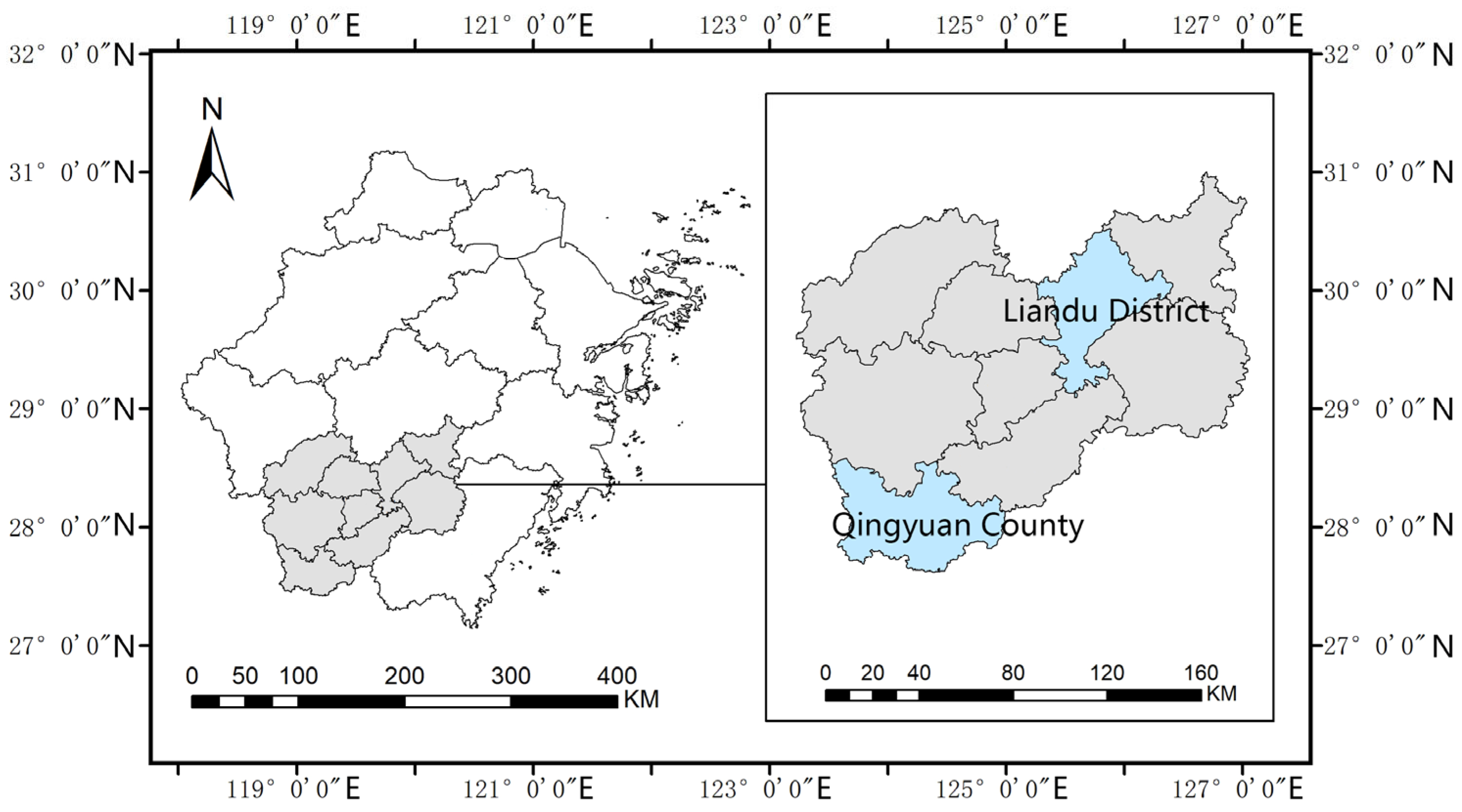
The mountainous area of southwest Zhejiang Province is located at the border of Zhejiang, Fujian, and Jiangxi Provinces. It generally refers to the Jinqu Basin and southwest Jiaojiang. Unlike the north Zhejiang plain and the hills in central Zhejiang, southwest Zhejiang is dominated by mountainous terrain and is known as “eight mountains, one water, and one field”. Located in the southeast of the Jiangshan–Shaoxing fault zone, it has complex geomorphologic features and numerous mountains belonging to the Wuyi mountain system. The southwest is dominated by Zhongshan, while the northeast is dominated by low mountains and valley basins. The terrain is generally high in the southwest and low in the northeast, which creates an important ecological barrier for Zhejiang and even East China. The area has a subtropical monsoon climate with four distinct seasons characterized by warmth and humidity, abundant rainfall, and a typical mountain climate. The unique natural ecological environment supported a historical farming culture, simple customs, and aesthetic pleasure for residents, as well as a number of distinctive local buildings.
The mountainous area in southwest Zhejiang Province has a long history and rich cultural resources. Cultural relics unearthed at Longdong Site in Jinyun County, Niumengang Site in Longquan City, Yingang Mountain in Songyang County, Houfu in Liandu District, and Haochuan Site in Suichang County suggest human reproduction and residence as early as the Neolithic Age, indicating primitive human settlements in southwest Zhejiang Province in this period. The Yongjia Rebellion in the Wei, Jin, and Southern and Northern Dynasties; the An-Shi Rebellion in the Tang Dynasty; the Jingkang Rebellion in the Southern Song Dynasty; and the Manchu and Qing customs entries in the late Ming and early Qing Dynasties drove the integration of the cultural features of the Central Plains and the Wuyue culture in Zhejiang. Many traditional villages emerged during this time and continue to have significant value. Terrain conditions limit the development of transportation and economy in the area but have also formed diverse and distinctive regional cultures, which play an important role in the overall structures, patterns, and textures of traditional villages.
The geographical division scope of southwest Zhejiang is not clearly defined in the literature. In the modern context, “southwest Zhejiang” generally includes Quzhou, Lishui, and Wenzhou, three prefecture-level cities, of which Lishui is the most representative. Southwest Zhejiang mainly refers here to Lishui. Research samples of traditional villages in the mountainous area of southwest Zhejiang were all selected from the administrative division of Lishui.
The city of Lishui is an area rich in traditional village resources. A total of 257 villages are listed in the Directory of Chinese Traditional Villages. The unique natural environment and local culture blend together there. The city’s spatial form and developmental evolution are highly representative of southwest Zhejiang. Traditional villages in Lishui have the following characteristics:
- Settlement morphologies reflect the natural environment and geographical characteristics, such as slope, slope direction, and altitude;
- Settlements cover a wide range of areas and represent different levels of economic and cultural development;
- Lishui comprehensively represents various types of settlements, such as farming, military, and trade, as well as the cultural characteristics of the different nationalities and clans inhabiting the area.
In order to make this research more scientific and reasonable, this paper carefully screens the research cases, and the screening process is divided into two steps: First, a preliminary screening: 28 traditional villages in two districts (Liandu District and Qingwon County) with representative and large spatial heterogeneity were selected from 257 villages in Lishui City as control groups, and a preliminary investigation was carried out to collect historical data related to spatial morphology (Figure 1). At the same time, the macrolocation characteristics of the spatial morphological evolution of traditional villages were analyzed. Secondly, a careful screening: according to the division of spatial morphological evolution mode in this study, three typical villages (Liangcun, Xixi Village, and Fengjiashan Village) with clear morphological texture, a complete evolution process, and more historical data were selected from 28 villages as quantitative analysis samples.
2.2. Research Method and Process
Our research design is roughly a two-step process. First, based on Professor Pu Xincheng’s quantitative research method [35], we analyzed the spatial morphological characteristics of the sample villages on a two-dimensional (2D) plane. The boundary of traditional villages was demarcated, and geometric features such as scale and boundary shape were mathematically analyzed using the boundary shape index, thus revealing the spatial form types of the villages and the corresponding synchronic characteristics [36].
Second, we used the selection degree of a space syntax line segment model to explore the characteristics of village centers under different measurement algorithms to characterize their evolution. We distributed an intention map survey to respondents and compared the results with space-syntax modeling analysis results to validate the features and rules defined in the first step. Finally, we clarified the diachronic spatial form evolution patterns and laws of the sample villages.
2.2.1. Research Method
- Boundary shape index
We used the boundary shape index to analyze the scale, boundary shape, and other geometric features of sample traditional villages and identify their spatial forms [35].
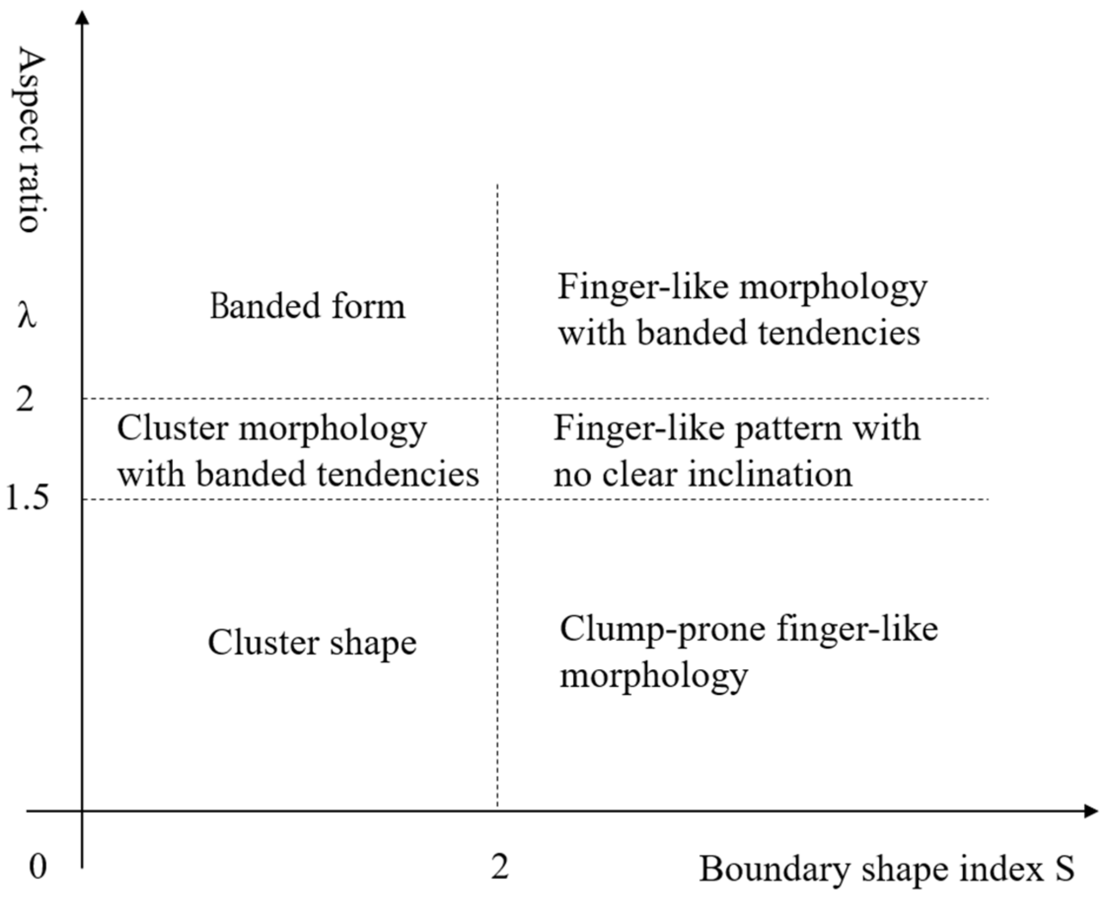
where S is the settlement boundary shape index; p is the perimeter of the boundary; A is the area; and λ is the length-to-width ratio of the boundary.
- Space syntax
Space syntax is a set of mathematical methods wherein the convex space, axis, line segment, and other models abstract a real space for the purposes of calculation. A series of parameters and variables in the field of topology can be applied to analyze spatial relations, structural characteristics, and space utilization efficiency. The axis model is straightforward and has high computational efficiency; it is widely used to analyze village spaces but lacks consideration of the spatial scale. We used the line segment model in this study with additional metric distance and angle calculation elements to determine the center of the spatial fabric according to the actual distance. This paper uses DepthMapX software for space syntax analysis. DepthMapX is an open-source, multi-platform software platform that is used to perform a series of spatial structure network analyses and visual analyses.
The choice parameter defines the number of times that a certain space appears on the shortest-path connections between other spaces, which measures the ability of a space to attract passing traffic:
where C is the selectivity; i ≠ x ≠ j; σ(i, x, j) is the shortest topological path of node space i through x to j; and d(x, j) is the shortest distance from node space x to j.
We determined the selection degree of the space syntax line segment model to calculate the fabric centers of villages in different periods. We then determined the deep evolutionary logic of traditional villages. Selection degrees may also be calculated based on the shortest topological path. However, in actual space, the selection may not be the shortest topological path but rather the shortest metric distance path or minimum angle sum path. Space syntax can be operated with different, specific algorithms for each selection degree. Unnecessary turning points are omitted from the line segment model when establishing the topological path, so the shortest topological path has an implicit correlation with the sum-of-minimum-corners path.
It is difficult for residents to accurately judge Euclidean distance in large-scale urban spaces. People tend to choose routes with small turning angles when moving through an urban area. However, some scholars have re-examined the application of the metric distance algorithm in small-scale spaces such as rural areas: Wang Haofeng collected flow data from local residents and tourists to study he spatial structure change in the Old Town of Lijiang and found that the same metric parameter had different explanatory abilities for differences in the flow of people between the two groups [37]. By analyzing the deep structures of traditional villages empirically, Dai Xiaoling confirmed that the fabric center of metric distance is meaningful in small-scale spaces [38]. Compared with the angle distance, it more accurately reveals the behavioral characteristics of local people.
We used the following two algorithms to investigate spatial morphological structure centers: the angle selection degree (Angular Choice), based on the minimum angular distance, which simulates the behavior of outside visitors in villages; and the shortest metric (Metric Choice), representing the “shortcut” behavior of local residents.
- City image theory
Kevin Lynch summed up five types of urban “intention” elements: the road, the interface, the region, the node, and the marker [39]. These five elements are interrelated and together form the city’s image (or “spatial image”). After more than half a century of development, the theory of urban intention has become a complete and sophisticated theoretical system. We analyzed the spatial images of traditional villages in the study area with field interviews and cognitive maps drawn based on a city image survey.
2.2.2. Data Sources and Processing Technique
- Data sources
Our data sources include text materials such as local records of Lishui, protection planning texts of traditional villages, and others. We also used remote sensing imagery derived from Google Earth, the United States Geological Survey website, and high-resolution satellite images from the Department of Natural Resources and the National Center for Basic Geographic Information. We also conducted a field survey, which was divided into two parts. The first part was a preliminary survey from August to September of 2021 to gain a basic understanding of the spatial form and structure of the villages through interviews. The second survey was conducted in the villages of Liang and Xixi in August, 2022. Respondents were interviewed and given intention maps to investigate their spatial cognition of the sample villages.
- Data processing
The first step in processing our data was the demarcation of settlement boundaries, as shown below.
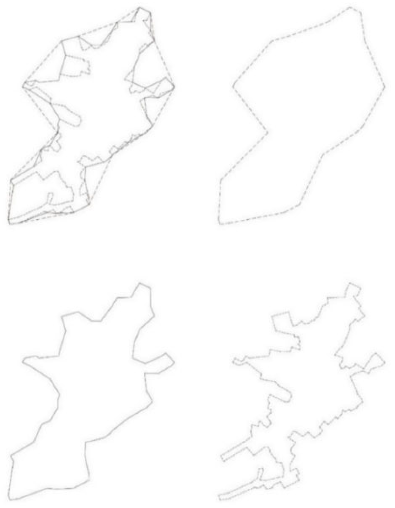
The boundary shapes of traditional villages form the primary material spaces of settlements enclosed by monomer buildings. Norberg Schulz proposed that morphology, in architectural language, refers to the boundaries of spaces; a settlement is the result of the agglomeration of individual buildings. If the perspective is enlarged to settlement level, then the boundary of a settlement is an external representation of its spatial form [35]. We abstracted the real settlement as a plane plan from the perspective of the graph base relation and analyzed the contour of the plane to determine the overall shape of the settlement (Figure 2).
Fortress-type settlements in the north are generally surrounded by structures such as external walls that form clear boundaries, while most settlements are more discrete and have looser structures with open boundaries and fuzzy boundary forms. We defined virtual boundaries accordingly. The demarcation of a virtual boundary determines the morphological characteristics of the settlement’s boundary. We used Pu Xincheng’s settings and delimited each settlement boundary with 100 m, 30 m, and 7 m as the maximum crossing distances.
We geographically registered satellite remote sensing images and drew a spatial texture map of the villages based on those and the field survey results. The axis of the street networks representing traditional villages was drawn in AutoCAD software, saved as a *. dxf file, and imported into Depthmap to establish a line segment model. We used that model to analyze the spatial structure, organization, order, and evolutionary characteristics of the settlements.
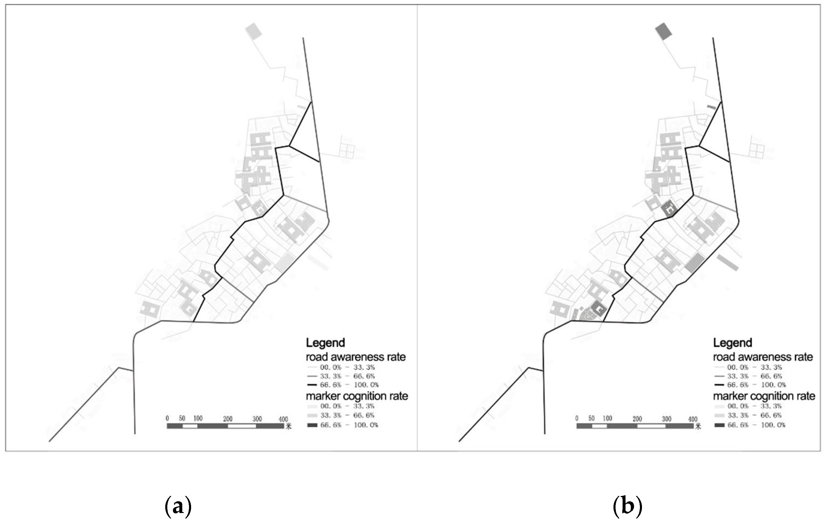
Survey respondents were divided into local residents and external visitors. The proportion of male and female respondents was kept as equal as possible, and all age groups were taken into account. The survey was conducted on weekdays and weekends. Questionnaires and cognitive image survey maps were distributed, and the respondents were asked to fill them in freely. The two groups of respondents completed the materials with reference to their own spatial cognition only. The most impressive intentions were counted, and the recognition rates of image elements were represented as frequencies, i.e., the proportions of the number of people choosing certain image elements in the total number of respondents. Liang Village: The respondents included 28 residents and 22 visitors. A total of 50 questionnaires were sent out on site, and 46 valid questionnaires were collected for an effective rate of 92%. A total of 50 cognitive images were distributed on site, and 33 effective cognitive images were recovered for an effective rate of 66%. Xixi Village: The survey subjects included 17 residents and 23 visitors. A total of 40 questionnaires were sent out on site, and 35 valid questionnaires were collected for an effective rate of 87.5%. A total of 40 cognitive images were distributed on site, and 29 effective cognitive images were recovered for an effective rate of 72.5%. The collected data can basically reflect the spatial structure characteristics of villages and meet the research requirements and purposes.
We used opacity, as defined by the statistical data, to represent the recognition rates for various elements. Different levels of opacity and widths were assigned to village elements such as roads, markers, and nodes. A darker color (higher opacity) represents higher frequency and thus a higher recognition rate, and vice versa.
3. Synchronic Spatial Morphologies of Traditional Villages
3.1. Classification of Traditional Village Spatial Morphology Types
We divided the spatial forms of traditional villages in the study area into four categories: concentrated mass, banded, scattered, and cluster, based on a literature review and the effects of the geographical environment [40].
Most rural settlements are formed spontaneously. Natural conditions often significantly influence the development and evolution of their spatial forms. The unique ecological environment and geographical conditions in southwest Zhejiang have not only nourished the development of rural settlements but also restricted the expansion of settlement spaces. The traditional villages in the study area are mainly distributed on mountain platforms, foothills, and valleys. The geographical characteristics of “eight mountains, one water, and one field” created various restrictions on traditional village lands. There are more small- and medium-sized concentrated blocky, banded villages of various types and fewer scattered and cluster-type villages (Table 1).
- Concentrated mass traditional villages
Due to the complex terrain conditions, traditional villages in the mountainous area of southwest Zhejiang are mainly distributed in intermountain basins and valley plains. When villages were initially constructed, builders tended to choose areas with flat land and proximity to water sources. The street patterns are mostly square checkerboard shapes or “well” font structures extending in a certain direction. Monomial buildings are dominated by traditional courtyard houses with rural streets as the core. The villages are dense on the inside and sparse on the outside, with a tendency for circular expansion.
- Banded traditional villages
Villages of this type are mainly distributed in valley areas among the mountains. Due to the constraints of terrain conditions, their lateral development is limited; they can only extend along the longitudinal direction of rivers. The street network also follows the direction of the river. The main road extends lengthwise, and the secondary roads intersperse laterally in the shape of a fishbone.
- Scattered traditional villages
Scattered villages are generally distributed in the foothills, where the terrain is high and the views are expansive, as these locations avoid mountain torrents, floods, and other natural disasters. The layout is a stepped pattern along a contour line, with building units oriented perpendicular to the contour to adapt to the steep terrain. The shape of streets and alleys is “Zhi”.
- Cluster traditional villages
Cluster-type villages are mainly distributed on the platform at the top of the mountain. There are scattered peaks and forests of different sizes within the village range. The villages form multiple clusters with compact buildings in each cluster, which are connected through an irregular road network.
3.2. Boundary Morphological Characteristics of Traditional Villages
The boundary morphology of a settlement can be determined according to the minimum external rectangle aspect ratio λ and the boundary shape index of the 2D plane of the village (Figure 3).
Based on the calculation results (Table 2), we defined the boundary shape of Meitian Village as a banded cluster. Surrounded by mountains on three sides and a river valley on one side, Meitian Village still retains its traditional spatial pattern. The buildings are mainly arranged on the gentle slope of the river valley. In Guanqiao Village, due to a relatively new road on the east side, the traditional zonal fishbone street shape expanded to the southeast, and the village boundary shape changed from zonal to finger-like. Buildings in Baizhe Yang Village are scattered along the mountain contour line, forming a cluster-type boundary. The village also shows a tendency to extend in a finger-like manner along the water system and toward the nearby valley. Hengkeng Village is located on a hilltop platform and is divided into two main clusters by a small hill in the middle. The main streets in the village extend to the northwest and southeast around the hill.
To sum up, it can be seen that traditional villages with different spatial forms have common boundary shape characteristics: The land-use types of most traditional villages in the study area are limited by geographical conditions. The boundary forms are mainly cluster-like and zonal, with a trend of finger-like expansion along rivers, roads, and in other directions. What were historically compact clusters and ribboned spatial forms have adapted over time to the terrain to facilitate intensive land usage. With the continuous development of these settlements, the terrain restrictions, economic transportation effects, river system effects, and other factors have driven the settlement forms toward balanced expansion, creating finger-like divergent boundaries.
4. Spatial Evolution Patterns of Traditional Villages
4.1. Spatial Morphological Evolution Mode of Traditional Villages
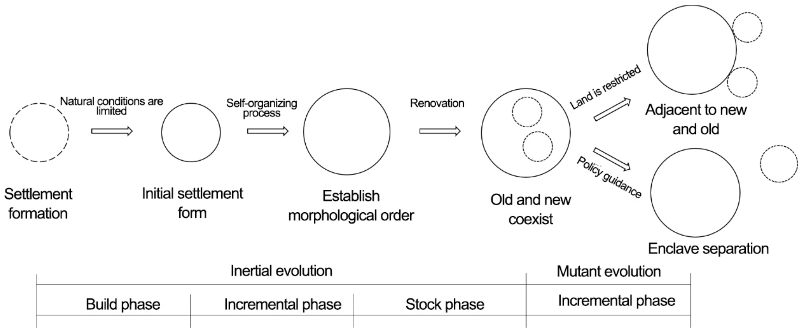
There are significant changes in the spatial form of a traditional village over time, which may occur suddenly; the modern form of the traditional village juxtaposes old and new elements. According to changes in the spatial patterns and fabric modes of old and new spaces, the evolution of the spatial forms in the study area can be divided into three types: adjacent construction of old and new, coexistence of old and new, and separate construction of an enclave (Table 3).
We found no changes in the spatial forms of villages across several sections on the temporal axis of their development and evolution. However, economic and technological innovation, population scale change, and transportation development at different points in time have altered the internal spatial structures and external morphologies of the villages, and these changes show certain rules. Due to a lack of historical image data, we began with the current situation of traditional villages and combined it with field research to deduce historical patterns. We used this information to analyze the relationship between the old and new spaces.
- New and old adjacency
For settlements with sufficient space, development, construction, and expansion occur in a certain direction based on the original settlement. There is a continuous relationship between the new and old village spaces. With urbanization, rural planning and construction practices unfold as village spaces transform and expand. The shapes of streets and lanes change from small-scale and tortuous to relatively straight and regular as the overall spatial form changes significantly over time.
- Old and new coexistence
Some villages are affected by their proximity to water resources in the mountains. The land-use conditions are limited, the architectural layout is relatively compact, the scale of the village has developed from incremental to stock type, and residential building renewal and transformation occur mostly via site reconstruction. This evolution mode continues the original architectural scale, pattern, texture, and spatial structure of the village, unlike the old-and-new-adjacency mode.
- Enclave separation
The construction of settlement enclaves may involve new and old villages far apart from each other (i.e., not connected), which is not discussed here. In other cases, the distance between old and new village enclaves is relatively small, and there is a connection between them in terms of regional features and other aspects. The old and new villages are not directly adjacent but share certain characteristics and co-evolve as embodiments of the ancient wisdom and culture of the traditional village.
4.2. Internal Organizational Characteristics of Traditional Villages
4.2.1. Deep Spatial Structures of New and Old Adjacent Construction (Liang Village)
Liang Village is located in the northwest of Lishui city center. The area has flat terrain, and Woxi runs through the village. Liang Village (Liangcun) was founded during the reign of Taiping and Xingguo of the Song Dynasty (AD 976-984) and has a history of more than 1000 years. In 1992, after several institutional changes and the withdrawal of the district and township expansion, it joined the Laozhu She Township of Liandu District.
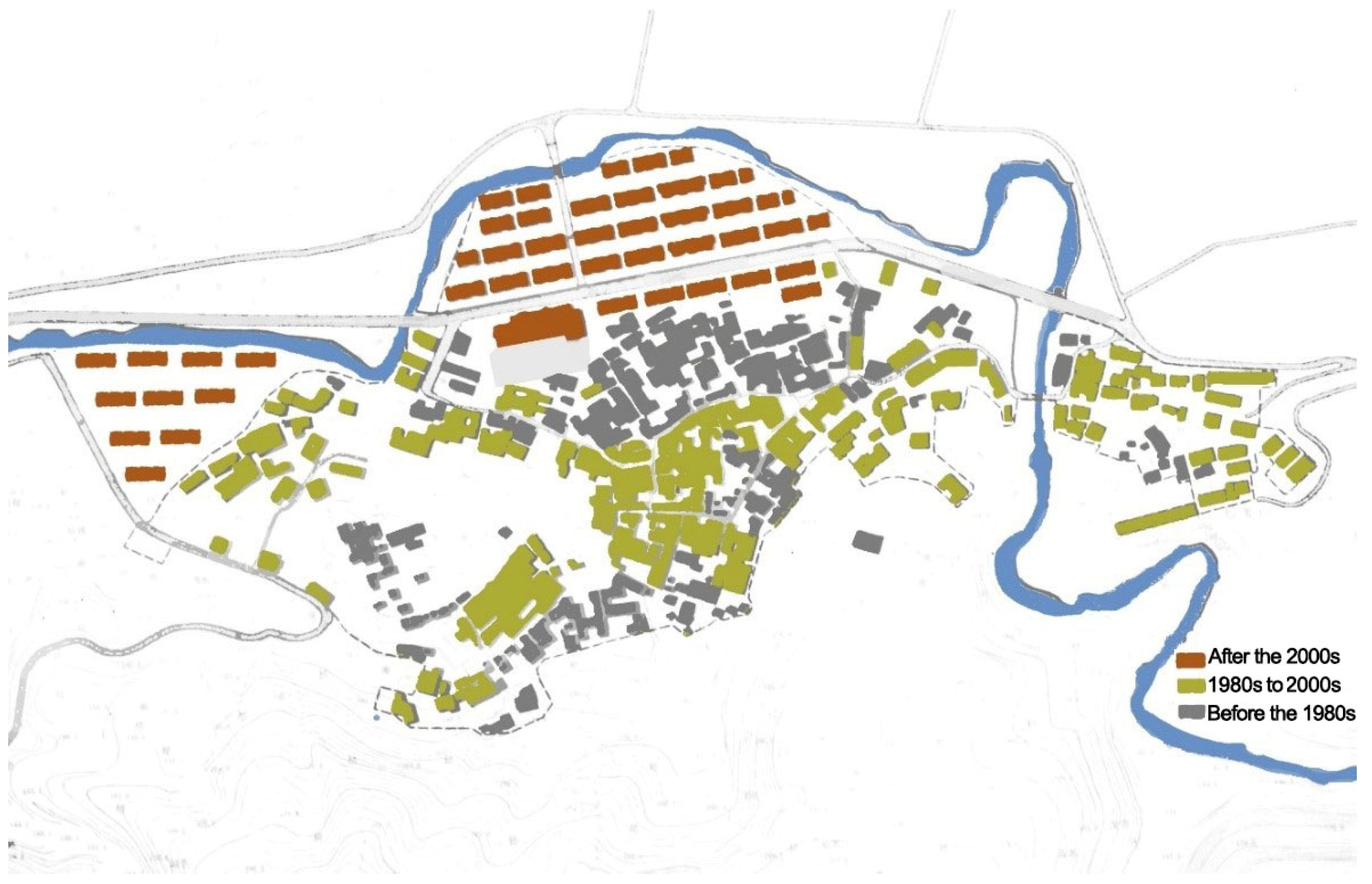
The zoning layout of Liangcun reflects the evolution of the village over time. Buildings constructed before the 1980s are well preserved, among which there are 28 ancient dwellings and buildings built before 1911, covering an area of about 17,400 square meters. From the 1980s to 2000, most of the buildings constructed in the central part of the village were rebuilt on the original site while maintaining the original pattern and texture. Some newly constructed residential buildings were scattered along the west side of the village. After 2000, the village area expanded to the north and west as construction progressed on the original cultivated land. The construction types are mainly multi-story residential buildings and various public buildings; the building facades are mostly ceramic tile veneers. The primary directions of spatial expansion and morphological evolution in Liangcun are northward and westward (Figure 4).
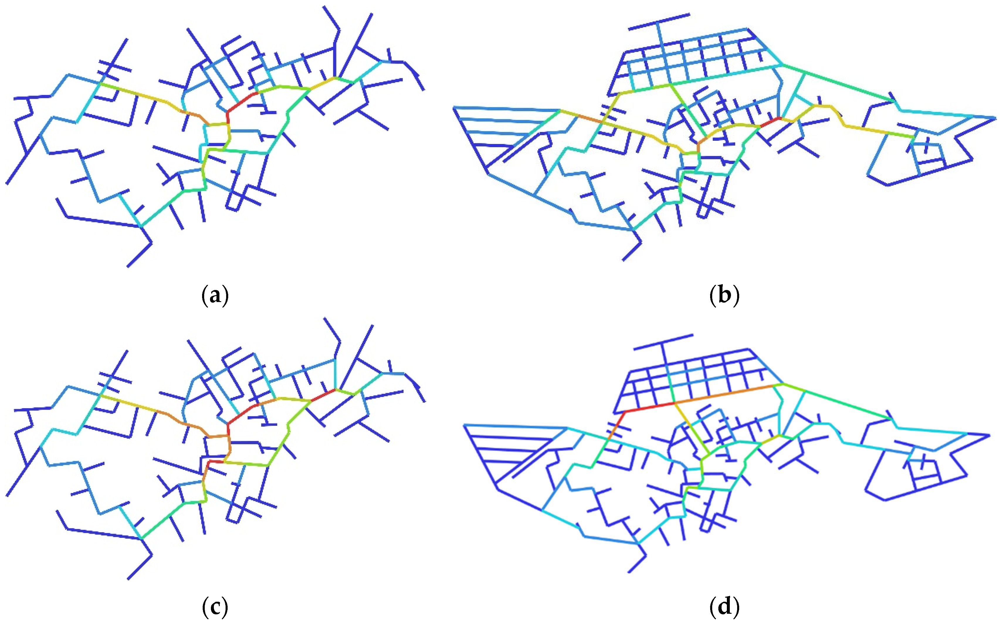
- Spatial syntactic analysis results
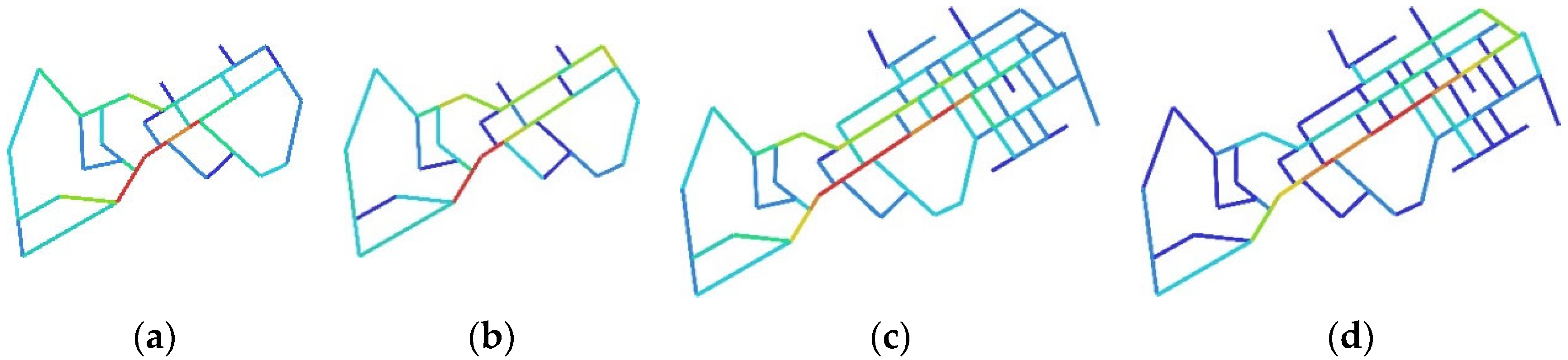
According to the changes in the morphology and texture of village streets and alleys, Liang Village was divided into the historical spatial morphological pattern (pre-1980s) and the current spatial morphological pattern. Two respective constitutive metric parameters were calculated (Figure 5).
The visual display rule of Depthmap software, for quantitative values, is to sort data in order by size and divide the set into 10 parts marked with a gradual change from red to blue. Red is the maximum (10% of the value) and indicates the location of the fabric center. This method allows quantitative data to be read qualitatively.
The four paired parameters in Figure 6 show that the two fabric centers of the historical spatial pattern of Liangcun coincide (Figure 6). The central location points to the public spatial core of the village (its ancestral hall). Thus, the theoretical determination of the fabric center of the model is consistent with the actual situation. The original spatial form also appears to efficiently organize the travel activities of both local residents and visitors, i.e., has “dual efficiency”. Compared with the historical spatial pattern, the two fabric centers of the current spatial pattern of Liangcun are offset to a certain extent and no longer fully coincide. Between old and new spaces, the degree of offset in the fabric center (angle selection) is higher than the selection degree (metric distance).
The perception of the outside visitors, represented by the angle selection degree, of the main street in front of the new multi-story residential area in Liangcun is more prominent than that of the historical streets. Additionally, the village is an “acquaintance society”. Villagers are familiar with the environment and have a clear cognition of their surroundings. The expansion of the village scope and the construction of new residential buildings have only slightly influenced the travel activities of indigenous people, so the deviation of the metric distance fabric center is small.
- 2.
- Spatial cognitive analysis results
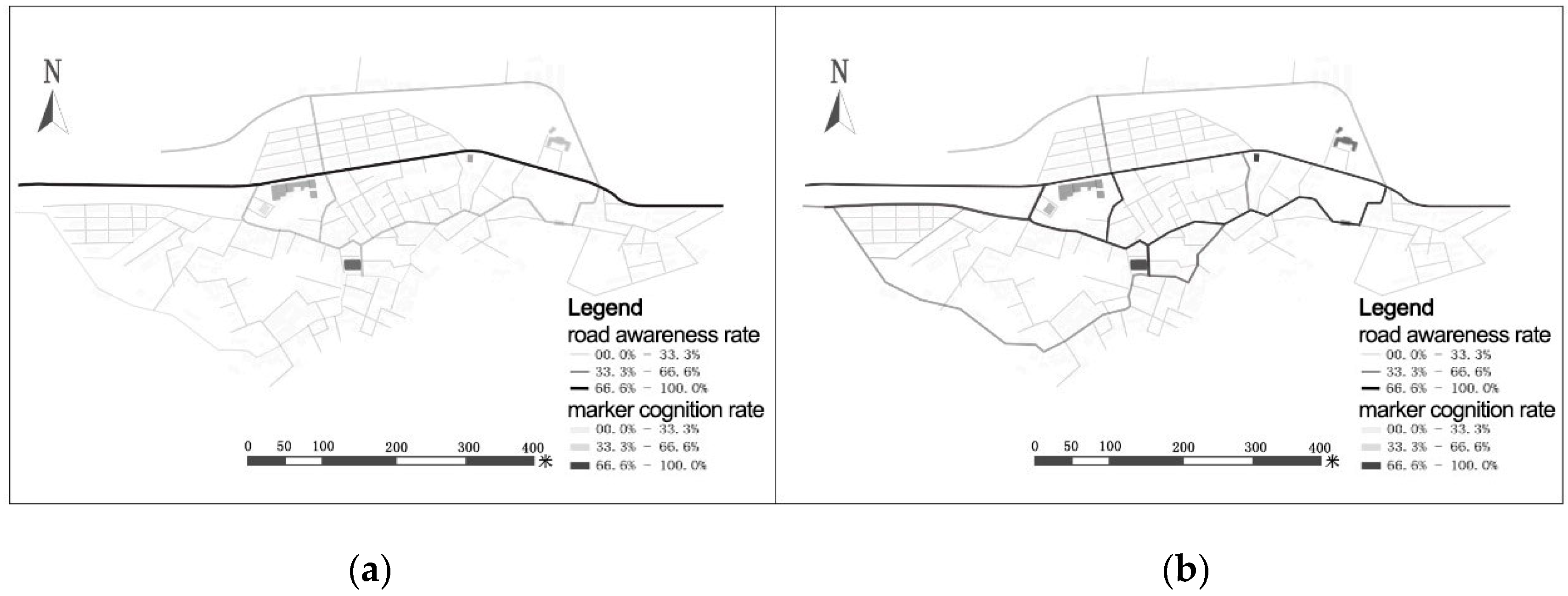
The most profound image for external visitors is that the main street connecting the main entrances and public service facilities in the village is a famous site (Figure 7). External visitors’ cognition of the road in the residents’ living area is low and is limited to intersections connected with the main street. Local residents have an overall grasp of the village space and understand the connection between the old village and the new village, as well as the whole village as it is situated within its external environment. In addition, most residents are familiar with the road structure around the ancestral temple and can describe some shortcuts frequently used in daily travel. In short, local residents have a clear understanding of the spatial structure of the village environment. For external visitors, cognition is mainly focused on the main street of the village rather than an in-depth understanding of the road network of ancient streets and alleys.
By comparing the above spatial cognition analysis results with the quantitative space syntax analysis results, we found that the selection degree of most spaces in Liangcun is proportional to the image recognition rate. The result sets mutually verify each other. External visitors represented by the angle selection degree have a clearer perception of Liwu Highway and a higher selection degree. Local residents represented by the metric distance selection have a clear cognition of the street structure of the old village. The space syntax theory, wherein “foreign visitors tend to take the least angular path and local residents tend to take the shortest path”, is in line with reality in Liangcun. It is reasonable to quantify the interpretation of the spatial activity patterns of the two groups through Space syntax.
4.2.2. Deep Spatial Structures of Traditional Villages with Old and New Coexistence (Xixi Village)
- Spatial syntactic analysis results
Xixi Village was built in the middle years of the Tang Dynasty. It is located in a mountain valley and has a crescent-shaped layout. One hundred and forty-eight ancient buildings from the Ming, Qing, and Republic of China periods remain in the village; the overall landscape and pattern of the village are well preserved. Most renovated residential buildings were reconstructed based on their original structures. New roads, schools, and a few residential buildings have been constructed in the east. Jigou Ancient Road runs from the village center to the north and south, with several ancient folk houses from the Ming, Qing, and Republic periods scattered on either side.
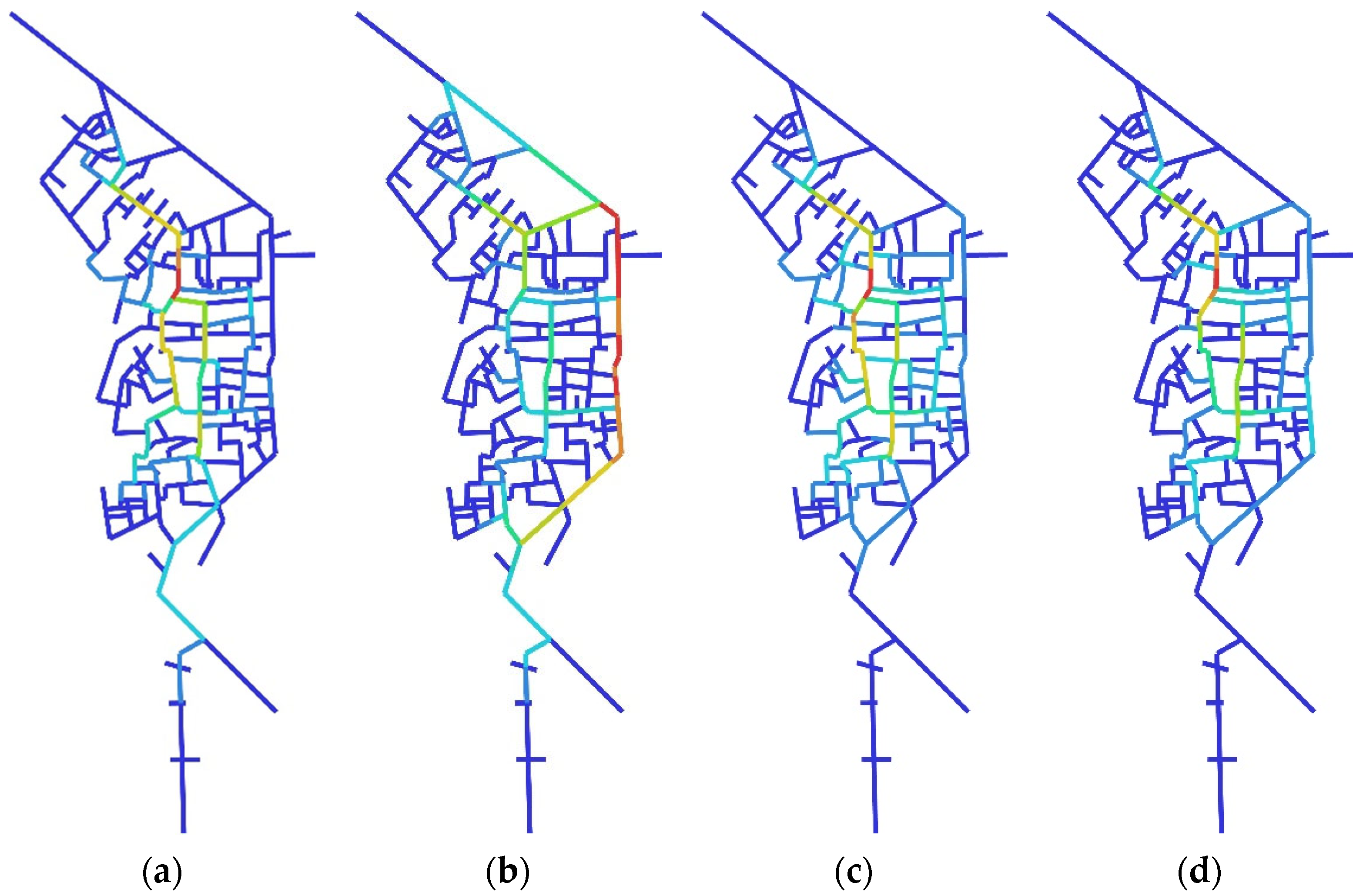
The present spatial pattern of Xixi Village basically retains the historical spatial pattern. Changes in the village street shape, pattern, and texture are not significant, so we did not make a comparison between the old and new spatial fabric centers (Figure 8). However, in analyzing the fabric centers of the current pattern, we found that the fabric centers presented by the angle selection degree versus the metric distance selection degree differ at different scales.
The two fabric centers are separate according to the global selection degree. The global angle center shifted to the east side of the highway (Figure 8A,C). However, the two types of centers on a small scale still coincide, pointing to the ancient road where the ancient folk houses are concentrated (Figure 8C,D). The long, straight traffic axis attracts people toward the fabric center, which accords with the cognitive effects expressed by visitors and residents. However, the original rural spatial form persists and stabilizes the original spatial structure. The original efficient spatial form of the settlement remains under the local selection degree of a small metric scale.
- 2.
- Spatial cognitive analysis results
We analyzed Xixi Village similarly to Liangcun. The spatial cognition law of Xixi Village is basically consistent with the space syntax analysis (Figure 9). However, there are some differences between the cognitive rules and space syntax analysis results for the ancient road in Xixi Village. The space syntax map shows that the cognition of external visitors regarding the main north–south road should be higher than the peripheral axis of Jigou Ancient Road, but the highest recognition rate of external visitors in the image survey statistical map is the ancient road and its surrounding environment. Xixi Village is an important tourist destination in Lishui and even across southwest Zhejiang, so tourists are the primary external visitors. Most tourists had a latent understanding of Jigou Ancient Road and its surrounding landmarks before the tour or a deep impression after the tour, so the statistical results were biased to a certain extent. This also shows that the spatial form of Xixi Village and its traditional morphological structures are well preserved.
Local residents have a clear understanding of Xixi Village’s various roads, markers, nodes, and other elements. Up to 58.8% of village residents believe that the village center is located at the node on the ancient road, and 41.2% believe that the center is located in the square or the hall along the main road, where many residential activities take place. Our space syntax selection degree analysis indicates that the village center within a 300 m statistical radius is the ancient road, though it falls along the main road used by vehicles over the global scope. The construction of long, straight-line traffic throughfares, the village square, and other public facilities has significantly affected the village center. Before the founding of the People’s Republic of China, village ancestral halls, squares, shops, and other public facilities were scattered on both sides of the ancient road. After the establishment of the long, straight main road in the east during the 1970s, the construction of cultural auditoriums, pension service centers, schools, and other new public service facilities encouraged local villagers, especially new inhabitants, to travel across the village differently. Our small-scale quantitative analysis suggests that the center of the traditional village was restored to some extent. To some extent, the imagery of tourists portrays the center and main axis of Xixi Village in its history.
4.2.3. Deep Spatial Structures of Traditional Villages with Enclave Separation (Fengjiashan Village)
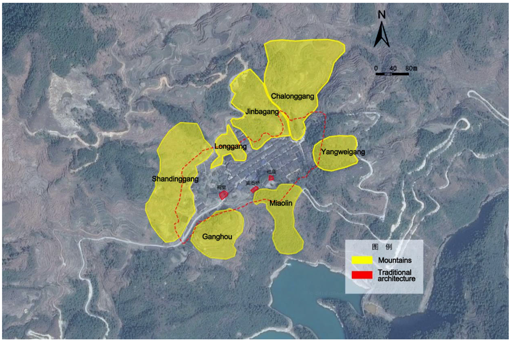
Fengjiashan Village is located in the southeast of Zhejiang Province. It is 75 km away from Qingyuan County. It is the southernmost administrative village in Lishui. There are five relics of the Qing Dynasty and 83 rammed-earth wooden buildings in the area, which were constructed between the Republic of China period and the 1980s. Fengjiashan Village borders Xixi Village in the east, Fujian Shouning and Zhenghe in the south, Zhenghe in the west, and Yuchuan Aoli in the north. The village is surrounded by mountains and water bodies, reflecting the ancient concept of “built by the mountains and living by the water”.
Fengjiashan Village has undergone two major changes. The first is village site enclave reconstruction. After the initial establishment of the village, it moved from Juxi to Lishan Chawan for economic reasons. In pursuit of livestock and poultry resources, the current village site was considered to have better feng shui, so homes and other village structures were erected accordingly.
The second is the expansion of farmland. In 1978, the population of the village expanded to more than 400 people; there were only 25 houses, with an average of 15 people living in each house. The villagers volunteered to dig hills and fill ditches to transform the terrain, and they leveled more than 80 mu of land on the south side of Jinzhaogang for the relocation of the whole village (Figure 10). In the initial planning stage, each house was constructed with a pig pen, a cattle pen, a toilet, and other facilities to support farming. The village road was designed to be four meters wide to support modern mechanical farming in the future. The village’s school was incorporated into the overall planning process to include the construction of three classrooms, teachers’ dormitories, six kitchens, and a playground area of over 1600 square meters.
The current spatial pattern of Fengjiashan Village is a typical zonal layout, spreading east–west along the main roads. The street network is fishbone-shaped. The spatial form of Fengjiashan Village evolved in a unique manner. The unified planning concept, as discussed above, was used to transform the low hills and gentle slopes in the area to construct a new village with less cultivated land. The village pattern after the reconstruction of the enclave continued the original clan-order organization logic, with ancestral temples as the core. Unified planning caused the spatial morphology and texture to change significantly in the subsequent expansion. The center shifted to the expanded central axis, reflecting the policy orientation of the time.
Enclaves evolve in tandem with the socioeconomic conditions of various periods of time. In ancient times, enclaves continued their original clan order and organizational spatial forms. In modern times, enclaves evolve with policy orientations as their spatial forms are mapped to their historical backgrounds. The enclave spatial form evolves significantly differently than the old-and-new-adjacency or the coexistence forms, particularly in terms of sudden occurrence (Figure 11). Apart from the natural disasters (e.g., landslides) in some settlements, most of the driving forces are anthropogenic factors such as human beliefs and policies.
We could not establish an effective spatial cognition analysis due to the small scale of Fengjiashan Village, which has fewer than 50 permanent residents.
5. Factors Influencing Traditional Village Spatial Morphology
The spatial forms of traditional villages are influenced by their natural environment, clan relationships, and other aspects that form basic structural frameworks. The village also must constantly adapt to social and cultural conditions in different time periods. These driving forces jointly shape the spatial forms of settlements and stabilize their morphologies over certain periods of time; changes in the driving factors promote the evolution of spatial forms. Knowledge of the factors influencing the formation and evolution of traditional village spatial forms may reveal the deep logic of the settlement space in the mountainous area of southwest Zhejiang.
5.1. Factors Influencing Spatial Form Generation
5.1.1. Topography and Landforms
The natural environment is the foundation of the spatial shape of a settlement. Site selection at the formation of the settlement centers on key production and living factors such as cultivated land, potential farm land, and water sources. Ancient settlers regarded the patterns of mountains and rivers, prioritized “backing mountains and water, bearing yin and yang”, and sought a closed and safe space conforming to nature. Traditional villages in the mountainous area of southwest Zhejiang are mostly distributed in the mountaintop terrace, the gentle slope area of the foothills, and the valley area between the mountains. Settlement forms were mainly clusters and bands at first.
5.1.2. Clan Lineage
Kinship in clans is key to the spatial organizational order and spatial form of a settlement. Traditional villages were generally self-organized and developed in a manner that was balanced and constrained by clans [40]. Many large-scale population movements to the south were carried out by clans, led by patriarchs, and jointly conducted among large numbers of people. Lineages based on blood relations have an important influence on the spatial forms of settlements. An ancestral hall or temple is often located at the core of a spatial structure [41]. Blood kinship and moral order play an important role in the establishment and continuation of spatial forms.
5.2. Influencing Factors of Spatial Morphological Evolution
5.2.1. Socio-Economic Conditions
Economic and technological conditions, such as road transportation and policy systems, can significantly alter the spatial forms of settlements [21]. In the era of farming, river systems, topography, and clan order jointly guided rural settlement forms from discrete distributions to heterogeneous agglomerations. With the transformation of village production modes and the development of modern engineering technology, the leading factors in village building site selection and spatial organization have shifted to transportation locations, policy systems, and other aspects. In recent years, the spatial boundaries of traditional villages have transformed into finger-like extensions, and the internal structure centers are offset by long and straight traffic axes.
5.2.2. Historical and Human Factors
The development of villages is a human endeavor. Human factors have an important influence on the spatial forms of settlements. For example, traditional villages were enclosed by physical boundaries for safety. Feng shui and other aspects of faith drove the establishment of enclaves. The migration of different clans, changes in kinship, the superposition of different spatial forms, and other factors are important as well.
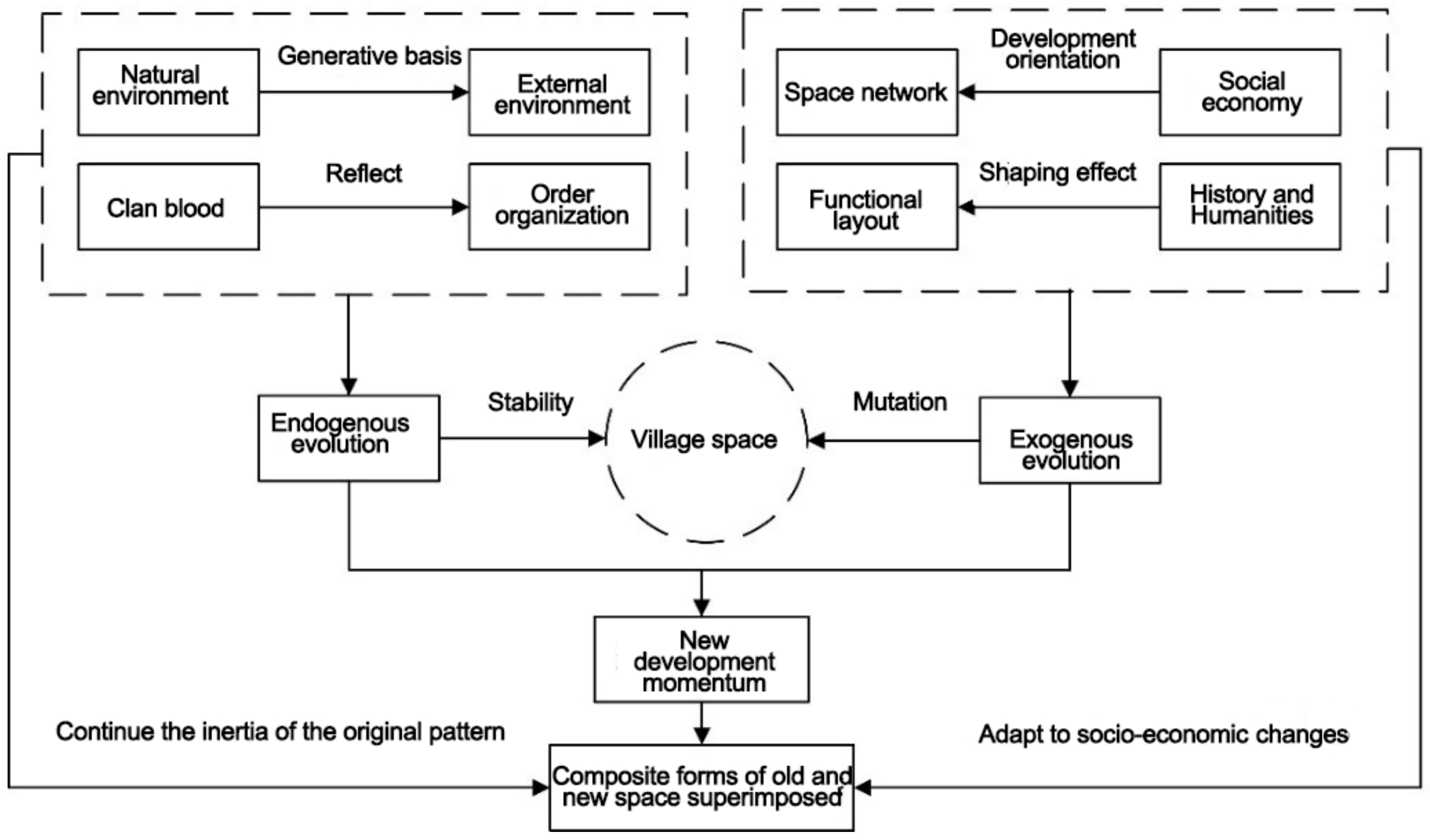
A rural settlement is a complex system that is affected by different endogenous and exogenous elements in terms of its spatial evolution [42]. The spatial forms of traditional villages evolve as a result of long-term adaptation to the natural environment and the mapping of kinship relationships in their settlement space, which is endogenous. Social and economic conditions such as traffic, policies, and other historical and anthropogenic factors may suddenly impact the evolution of the spatial form, which is exogenous. These two evolutionary mechanisms are inseparable (Figure 12).
In general, the natural environment is the basis for the establishment of a village’s spatial form, but human factors are important in terms of its construction, internal order, and evolution. The spatial form is affected by “stability maintenance” and “sudden change” mechanisms simultaneously. The game between these two mechanisms drives the morphological evolution across the multi-temporal overlapping and integration of old and new spaces.
5.3. Spatial Morphological Evolution Mechanism
Traditional villages in the mountainous area of southwest Zhejiang have undergone a lengthy evolutionary process to form their current morphological pattern (Figure 13).
Spontaneous and external constructive forces jointly shape the spatial forms of villages. The evolution of traditional village spatial forms thus shows similar laws despite some uniqueness during certain periods of time. In the early formation of settlements, construction land continually expanded into a certain organizational order and spatial form framework. The original site was renewed in the stock stage. The boundaries of the original settlement must be recreated as necessary for construction to move forward in a certain direction, which is represented by adjacency and enclave spatial forms.
6. Conclusions
6.1. Conclusions
The spatial form of a settlement is an external reflection of the complex internal structure created by various material and immaterial elements. We deployed quantitative analysis methods in this study to explore the outer representations and evolution patterns of village spatial forms in the mountainous area of southwest Zhejiang. Our conclusions can be summarized as follows:
- Geographical conditions have influenced the land use of traditional villages in the mountainous area of southwest Zhejiang. The boundary forms of traditional villages are mainly cluster-shaped and zonal, with a trend of finger-like expansion along rivers and roads.
- The traditional historical spatial forms of settlements can effectively organize the travel activities of local residents and external visitors. The corresponding dual fabric centers basically coincide. Modernization and the various geographical environments and socio-cultural conditions of each village have created differences in the evolution of different spatial forms. There are different degrees of deviation in the two fabric centers of different settlements.
- Natural environments and kinship relationships shaped the basic structural frameworks of traditional village spatial forms in the study area, while economic, technological, social, and human factors were the primary driving forces of their morphological evolution. The game between the two forces of “stability maintenance” and “sudden change” created overlapping and integration in the spatial forms of traditional villages over time.
6.2. Suggestions
Traditional villages have ushered in new development opportunities over time. The results of this work may provide guidelines for the continuation and protection of the spatial morphologies of traditional villages.
- The small-scale, gradual renewal of a traditional village should be conducted to protect its original texture. There is a serious sense of disconnection between the new spatial textures formed under the large-scale, long, straight traffic axis and the ancient parts of a village. In renovating the village space, the original pattern should be fully considered, the spatial scale of the street network should be carefully selected, the public facilities should be rationally arranged, and the integrity and continuity of the regional style should be maintained.
- Spatial isomorphism should be followed while spatial forms are extended in accordance with historical characteristics. The space syntax model can be combined with interview data, historical images, and the old spatial orientation of small-scale spatial structures to trace the original structure of a village. The historical core of the village can be continued by following similar spatial development rules so as to protect the sense of place and vitality of the village space.
- Interpretations of traditional culture should be strengthened to excavate the deep connotations among village spatial forms, with a special focus on villagers’ self-identifications. In the architectural planning of some traditional villages, a large area of the old village may be demolished while only cultural relic protection units are retained. The Venice Charter and Xi’an Declaration point out that the protection of historical sites includes not only individual buildings but also the surrounding environment. In the future, village development and protection should occur in accordance with the cultural background, spatial texture, and overall style of the traditional village.
Author Contributions
Quan Zhu: Conceptualization, methodology, validation, formal analysis, investigation, resources, writing—review and editing. Shuang Liu: Investigation, validation, formal analysis, data curation. All authors have read and agreed to the published version of the manuscript.
Funding
This research was funded by the Zhejiang Province Basic Public Welfare Research Project, Digitally-driven Future Rural Scene Design and Planning Method Model Research, grant number (GN22E080817).
Data Availability Statement
Not applicable.
Conflicts of Interest
The authors declare no conflict of interest.
References
- Tao, H.; Ma, G.Q.; Ran, F.X.; Qiao, J. The Classification and Development Model of Traditional Villages from H-I-S Perspective: A Case Study of Handan. Tour. Trib. 2019, 34, 82–95. (In Chinese) [Google Scholar]
- Gen, P.; Chen, W.; Gao, J.L.; Wu, J.W. Research Progress on the Evolution of Spatial Patten of Rural Settlements in China. Mod. Urban Res. 2022, 11, 69–75+100. (In Chinese) [Google Scholar]
- Hu, M.R. Spatial Morphological Characteristics of Traditional Waterfront Villages along the Yangtze River in Sichuan Basin. Master’s Thesis, Southwest University of Science and Technology, Mianyang, China, 1 May 2021. (In Chinese). [Google Scholar]
- Wu, L.P.; Liu, C.L.; Gong, J.; Jiao, L.P. The Syntactic Analysis on the Evolution and Characteristics of Traditional Village Spatial Morphology—A Case Study of Jiaoxi Village. J. Geomat. Sci. Technol. 2020, 37, 628–635. (In Chinese) [Google Scholar]
- Hu, Z.; Zheng, W.W.; Liu, P.L.; Liu, X.Y. The forms and structures of traditional landscape genome maps: A case study of Hunan Province. Acta Geogr. Sin. 2018, 73, 317–332. (In Chinese) [Google Scholar]
- Xin, R.H.; Zeng, J.; Huang, Y.H. Study on the Protection of Traditional Villages in Southwest Mountainous Areas Based on Ecological Wisdom. Chin. Landsc. Archit. 2019, 35, 95–99. (In Chinese) [Google Scholar]
- Yang, W.B.; Wang, M.Y.; Liu, L. Analysis on the Spatial Form of Traditional Settlements in Northern Mountainous Areas under the Pressure of Floods: Taking Houlinhe Village of Wu’an City as an Example. Mod. Urban Res. 2021, 7, 118–124. [Google Scholar]
- Jin, L.C.; Jiao, S. A Graph Theory Based Study on the Structure of Public Space in Traditional Villages. Planners 2019, 35, 52–57. [Google Scholar]
- Xu, H.; Zhao, H.S.; Liu, F. Preliminary Study in Syntactical of the Spatial Form of Traditional Villages: A Case Study of Jiangshan Hejia-Wujia Village in Guchen Town, Gaochun County, Nanjing. Mod. Urban Res. 2016, 1, 24–29. [Google Scholar]
- Mao, X.M. Research on the Living Protection and Utilization of Traditional Commercial Villages in the Second Village of Qinghu, Jiangshan City. Master’s Thesis, Zhejiang University, Hangzhou, China, 9 September 2020. [Google Scholar]
- Wang, Q. Study on Typology of Traditional Villages in North Henan Province. Master’s Thesis, Northeast Forestry University, Harbin, China, 1 June 2021. [Google Scholar]
- Miao, Y.K.; Luo, J.P.; Chang, J. Application of Gis in Chinese Traditional Village Research. Ind. Constr. 2021, 51, 24–29. [Google Scholar]
- Chen, Z.; Ji, Y.; Zhou, H.T.; Chen, W. A Study on the Evolution and Adaptation of Traditional Chinese Villages Based on Complex Adaptative System(CAS). Archit. J. 2014, S1, 57–63. [Google Scholar]
- Yu, H.; Zhang, P.; Li, J.; Zhang, Z.H. Research on Village Classification and Development Strategies under the Concept of Five States Fusion: Taking Traditional Villages in Southern Shaanxi as an Examplel. South Archit. 2021, 4, 105–111. [Google Scholar]
- Lin, Z.R.; Zhang, J.P.; Zhang, X.; Ding, Z.H. Study on the Evolution of Spatial Form of Business-Oriented Traditional Villages in Jingxing Ancient Road: A Case Study of Xijiao Village, Pingding County, Shanxi Province. Mod. Urban Res. 2019, 9, 10–16. (In Chinese) [Google Scholar]
- Chai, X.R.; Tao, W.; Lu, J. Formation and evolution of traditional village material form based on Conzenian approach: A case study of Nongme village of dai ethnic. Hum. Geogr. 2022, 37, 90–99. (In Chinese) [Google Scholar]
- Yang, R.; Lu, J.F.; Li, W. Evolution and Influential Mechanism of Multi-dimensional Space of Typical Traditional Villages in the Metropolitan Fringe of Pearl River Delta. Econ. Geogr. 2022, 42, 190–199. (In Chinese) [Google Scholar]
- Yang, X. Advances in Quantitative Research Methodologies for the Spatial Layout of Rural Settlement in Recent 20 Years. Urban Plan. Int. 2020, 35, 72–80. (In Chinese) [Google Scholar]
- Du, J.; Hua, C.; Yu, Y.F. Research on Spatial Evolution of Traditional Settlements: The Case Study of Qianzhong Tunpu. Urban Dev. Stud. 2017, 24, 47–53. (In Chinese) [Google Scholar]
- Chen, Y. Spatial Succession of Old and New settlements in Traditional Villages Based on Space Syntax: A Case Study of Luci Village, Jingning County, Zhejiang Province. Master’s Thesis, Zhejiang University, Hangzhou, China, 1 May 2021. [Google Scholar]
- Tao, W.; Chen, H.Y.; Lin, Y.J. Spatial form and spatial cognition of traditional village in syntactical view: A case study of Xiaozhou Village, Guangzhou. Acta Geogr. Sin. 2013, 68, 209–218. [Google Scholar]
- Yue, T.Q. Study on the Public Space Characteristics of Traditional Villages in the Suburbs of Beijing Based on Space Syntax. Master’s Thesis, Beijing University of Civil Engineering and Architecture, Beijing, China, 1 August 2020. [Google Scholar]
- Chen, C.; Li, B.H.; Yuan, J.L.; Yu, W. Spatial Morphology Cognition of Traditional Village Based on Space Syntax: A Case Study of Qinchuan Village of Hangzhou. Econ. Geogr. 2018, 38, 234–240. (In Chinese) [Google Scholar]
- Duan, S.J. Study on the Spatial Form of Traditional Villages in Guilin. Master’s Thesis, Beijing Forestry University, Beijing, China, 10 June 2020. [Google Scholar]
- Yang, Y.; Hu, J.; Liu, D.J.; Jia, Y.Y.; Jiang, L. Spatial Structure ldentification and Influence Mechanism of Miao Traditional Villages in Guizhou Province. Econ. Geogr. 2021, 41, 232–240. [Google Scholar]
- Li, J.L.; Chu, J.L.; Li, Y. Research on the Spatial Distribution Pattern and Protection and Development of Ancient Huizhou Traditional Villages. Chin. J. Agric. Resour. Reg. Plan. 2019, 40, 101–109. [Google Scholar]
- Liang, H.Y. A Study on the Public Space of Traditional Settlements in Jindong District Jinhua. Ph.D. Thesis, Beijing Forestry University, Beijing, China, 1 October 2018. [Google Scholar]
- Li, B.; Yang, B.; Tao, Q.H.; Zuo, Q.; Wu, L.P.; Gao, H.; Liu, Y.X.; Li, W. Study on spatial pattern and influencing factors of traditional villages in Hunan province. Sci. Surv. Mapp. 2021, 46, 150–157. [Google Scholar]
- Huang, X.W. Spatial Research of Traditional villages and Buildings in Meishan Area of Central Hunan Province. Ph.D. Thesis, South China University of Technology, Guangzhou, China, 12 August 2020. [Google Scholar]
- Gan, Z.K. Spatial Characteristics Research on Hebei Historic Villages. Ph.D. Thesis, Beijing University of Civil Engineering and Architecture, Beijing, China, 1 August 2020. [Google Scholar]
- Yu, X. Research on spatial Evolution Characteristics and Mechanism oftraditional industrial Villages in Southern Jiangsu province. Master’s Thesis, Xi’an University of Architecture and Technology, Xi’an, China, 1 June 2021. [Google Scholar]
- Ma, Y.; Huang, Z.X. Research on spatial distribution and accessibility of the traditional villages in the urban agglomeration on the middle reaches of the Yangtze River based on GWR model. Hum. Geogr. 2017, 32, 78–85. (In Chinese) [Google Scholar]
- Xiao, L.; Wei, C.Y. Knowledge Map on the Study of Chinese Rural Settlement Form Based on CSSCI. Econ. Geogr. 2021, 41, 148–157. (In Chinese) [Google Scholar]
- Qin, X.Y. Study on the Spatial Evolution and Restructuring Strategy of Villages in Bai-yang Lake, Xiongan New Area. Master’s Thesis, Beijing University of Civil Engineering and Architecture, Beijing, China, 1 August 2020. (In Chinese). [Google Scholar]
- Pu, X.C. Quantitative Research on the Integrated Form of the Two-dimensional Plan to Traditional Rural Settlement. Ph.D. Thesis, Zhejiang University, Hangzhou, China, 1 June 2012. (In Chinese). [Google Scholar]
- Song, F.; Ren, Y.Y.; Feng, M. Spatial Characteristics and Influencing Factors of Traditional Villages in Loess Plateau Gully Area: A Case of National Traditional Villages in Yulin City of Shaanxi Province. Areal Res. Dev. 2021, 40, 162–168. (In Chinese) [Google Scholar]
- Wang, H.F.; Rao, X.J.; Feng, C. Spatial segregation and social marginalization: On the transformation of lijiang’s ancient city. City Plan. Rev. 2014, 38, 84–90. (In Chinese) [Google Scholar]
- Dai, X.L.; Pu, X.C.; Dong, Q. Explore the Deep Spatial Structure of Traditional Villages by Space Syntax Approach. Chin. Landsc. Archit. 2020, 36, 52–57. (In Chinese) [Google Scholar]
- Wang, H.F. The Spatial-functional Dynamism and Settlement Morphology of Huizhou’s Traditional Villages. Archit. 2008, 2, 23–30. (In Chinese) [Google Scholar]
- Zhang, S. A Study on Traditional Villages as a Form of Human Settlement and Their Integrated Conservation. Urban Plan. Forum 2017, 2, 44–49. (In Chinese) [Google Scholar]
- Fu, M.Z.; Yan, F.Y.; Lin, J.T. Study on Spatial Evolution and Development of Northern Zhejiang Rural Settlements Driven by Human-land Relationship. Areal Res. Dev. 2019, 38, 152–157. (In Chinese) [Google Scholar]
- Deng, W.; Hu, H.Y.; Yang, R.X.; He, Y. A Study on the Dual-Structure Characteristics of Traditional Rural Settlements and Implications. Urban Plan. Forum 2019, 6, 101–106. (In Chinese) [Google Scholar]
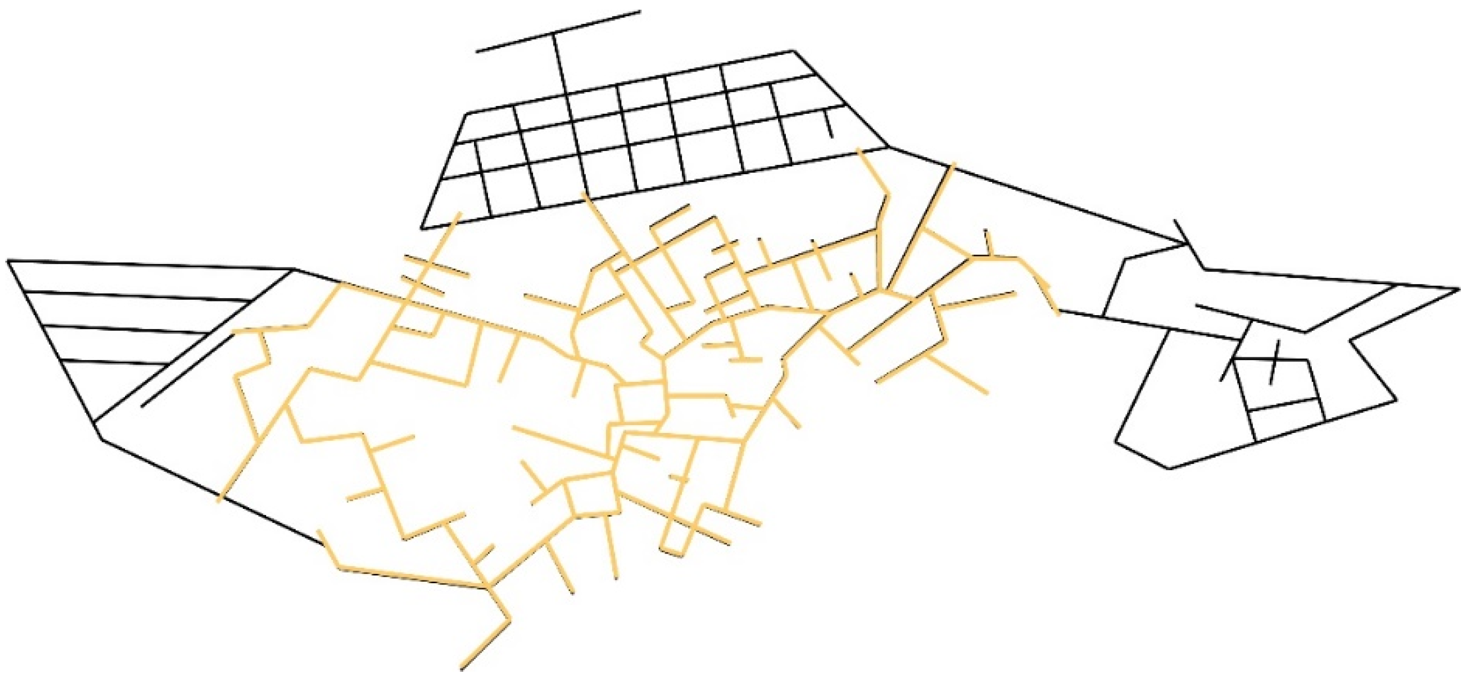
Figure 1.
Scope of study area.

Figure 2.
Umeda Village settlement boundaries.

Figure 3.
Settlement boundary shape index classification.

Figure 4.
Age analysis of Liangcun buildings.

Figure 5.
Relationship between traditional and current spatial structures in Liangcun.

Figure 6.
Syntactic analysis of Liang Village space. (a) Global metric distance selectivity under historical spatial form of Liang Village; (b) global metric distance selection degree under current spatial form of Liang Village; (c) global angle selectivity under historical spatial form of Liang Village; (d) global angle selection degree under current spatial form of Liang Village.

Figure 7.
Cognitive imagery of different space users in Liang Village. (a) Outside visitors; (b) local residents. Notes: Road awareness rate: Reflect people’s understanding of the road; Marker cognition rate: Reflect people’s understanding of buildings and nodes.
Figure 7.
Cognitive imagery of different space users in Liang Village. (a) Outside visitors; (b) local residents. Notes: Road awareness rate: Reflect people’s understanding of the road; Marker cognition rate: Reflect people’s understanding of buildings and nodes.

Figure 8.
Spatial syntactic analysis of Xixi Village. (a) Global metric distance selection degree in Xixi Village; (b) global angle selection degree of Xixi Village; (c) Xixi Village 300 m radius metric distance selection degree; (d) Xixi Village 300 m radius angle selection.
Figure 8.
Spatial syntactic analysis of Xixi Village. (a) Global metric distance selection degree in Xixi Village; (b) global angle selection degree of Xixi Village; (c) Xixi Village 300 m radius metric distance selection degree; (d) Xixi Village 300 m radius angle selection.

Figure 9.
Cognitive imagery of different space users in Xixi Village. (a) Outside visitors; (b) local residents. Notes: Road awareness rate: Reflect people’s understanding of the road; Marker cognition rate: Reflect people’s understanding of buildings and nodes.
Figure 9.
Cognitive imagery of different space users in Xixi Village. (a) Outside visitors; (b) local residents. Notes: Road awareness rate: Reflect people’s understanding of the road; Marker cognition rate: Reflect people’s understanding of buildings and nodes.

Figure 10.
Pattern of Fengjiashan Village. Notes: Traditional architecture: Preserved valuable and historical buildings.
Figure 10.
Pattern of Fengjiashan Village. Notes: Traditional architecture: Preserved valuable and historical buildings.

Figure 11.
Spatial syntactic analysis of Fengjiashan Village. (a) Global metric distance selection degree under historical spatial form of Fengjiashan Village enclave after reconstruction; (b) global angle distance selection degree under historical spatial form of Fengjiashan Village enclave after reconstruction; (c) global metric distance selection degree in current spatial form of Fengjiashan Village; (d) global angular distance selection degree in current spatial form of Fengjiashan Village.

Figure 12.
Logical framework of traditional village spatial morphology evolution.

Figure 13.
Spatial morphological types and evolutionary patterns of traditional villages in mountainous area of southwest Zhejiang.
Figure 13.
Spatial morphological types and evolutionary patterns of traditional villages in mountainous area of southwest Zhejiang.


Table 1.
Spatial morphological division of traditional villages in the mountainous area of southwest Zhejiang.
Table 1.
Spatial morphological division of traditional villages in the mountainous area of southwest Zhejiang.
| Spatial Form Type | Icon | Representative Village | Village Texture | Corresponding Sample | |
|---|---|---|---|---|---|
| Concentrated mass |  | Meitian Village |  | Guanqiao Village, Guanling Village, Lianji Village, Liang Village, Xikeng Village, Xixi Village, Batou Village, Nanyang Village | |
| Banded |  | Guanqiao Village |  | Kuchuan Village, Kukengyuan Village, Xiazhuang Village, Aotou Village, Fengjiashan Village, Huangtan Village | |
| Scattered |  | Baizheyang Village |  | Gongshan Village, Saikeng Village, Houxi Village | |
| Cluster |  | Hengkeng Village |  | Yantou Village, Aoli Village |
Table 2.
Boundary morphological characteristics of traditional villages in southwest Zhejiang (unit: meters).
Table 2.
Boundary morphological characteristics of traditional villages in southwest Zhejiang (unit: meters).
| Representative Village | Boundary Perimeter P | Aspect Ratio λ | Area A | Shape Index S | Boundary Form |
|---|---|---|---|---|---|
| Meitian Village | 1054 | 1.813 | 53,840 | 1.203 | Cluster morphology with banded tendencies |
| Guanqiao Village | 3365 | 2.231 | 81,637 | 3.199 | Finger-like morphology with banded tendencies |
| Baizheyang Village | 1441 | 1.414 | 36,247 | 2.088 | Clump-prone finger-like morphology |
| Hengkeng Village | 1561 | 1.437 | 29,996 | 2.463 | Clump-prone finger-like morphology |
Table 3.
Spatial morphological evolution pattern of traditional villages in southwest Zhejiang.
| Spatial Form Evolution Mode | Representative Village | Schematic Diagram | |
|---|---|---|---|
| 1964 Remote Sensing Images | 2022 Remote Sensing Imagery | ||
| Adjacent new and old | Liang Village |  |  |
| Old and new coexist | Xixi Village |  |  |
| Enclave separation | Fengjiashan Village |  |  |
Disclaimer/Publisher’s Note: The statements, opinions and data contained in all publications are solely those of the individual author(s) and contributor(s) and not of MDPI and/or the editor(s). MDPI and/or the editor(s) disclaim responsibility for any injury to people or property resulting from any ideas, methods, instructions or products referred to in the content. |
© 2023 by the authors. Licensee MDPI, Basel, Switzerland. This article is an open access article distributed under the terms and conditions of the Creative Commons Attribution (CC BY) license (https://creativecommons.org/licenses/by/4.0/).
Share and Cite
MDPI and ACS Style
Zhu, Q.; Liu, S. Spatial Morphological Characteristics and Evolution of Traditional Villages in the Mountainous Area of Southwest Zhejiang. ISPRS Int. J. Geo-Inf. 2023, 12, 317. https://doi.org/10.3390/ijgi12080317
AMA Style
Zhu Q, Liu S. Spatial Morphological Characteristics and Evolution of Traditional Villages in the Mountainous Area of Southwest Zhejiang. ISPRS International Journal of Geo-Information. 2023; 12(8):317. https://doi.org/10.3390/ijgi12080317
Chicago/Turabian StyleZhu, Quan, and Shuang Liu. 2023. "Spatial Morphological Characteristics and Evolution of Traditional Villages in the Mountainous Area of Southwest Zhejiang" ISPRS International Journal of Geo-Information 12, no. 8: 317. https://doi.org/10.3390/ijgi12080317
Note that from the first issue of 2016, this journal uses article numbers instead of page numbers. See further details here.