Article

Assessing SDI Implementation Scenarios to Facilitate Emergency Mapping Operations in the Dominican Republic

by
Gregorio Rosario Michel
1,2,3,*,
María Ester Gonzalez-Campos
4,
Fernando Manzano Aybar
5 and
Joep Crompvoets
1
1
Public Governance Institute (PGI), KU Leuven, 3000 Leuven, Belgium
2
Escuela de Agrimensura, Facultad de Ingeniería y Arquitectura, Universidad Autónoma de Santo Domingo (UASD), Cuidad Universitaria, Santo Domingo 10103, Dominican Republic
3
Escuela de Agrimensura, Universidad Nacional Pedro Henríquez Ureña (UNPHU), Santo Domingo 10602, Dominican Republic
4
Departamento de Geografía, Facultad de Arquitectura, Urbanismo y Geografía, Universidad de Concepción, Concepción 4070386, Chile
5
Escuela de Ingeniería Electrónica, Facultad de Ciencias e Ingenierías, Universidad APEC, Santo Domingo 10100, Dominican Republic
*
Author to whom correspondence should be addressed.
ISPRS Int. J. Geo-Inf. 2023, 12(5), 184; https://doi.org/10.3390/ijgi12050184
Submission received: 23 February 2023 / Revised: 20 April 2023 / Accepted: 22 April 2023 / Published: 28 April 2023

Abstract

:
The Dominican Republic (DR) is a small island developing state (SIDS) highly exposed to disaster-risk phenomena, such as earthquakes, hurricanes, etc. The Spatial Data Infrastructure (SDI) enables coordination and sharing of spatial information and services from multiple sources, while emergency mapping operations (EMO) help decision-makers build a common operational picture (COP) of impacted communities. Assessment of future scenarios for SDI implementation to meet emergency mapping goals requires the consideration of a wide range of stakeholders with different objectives. We make use of multi-actor multi-criteria analysis (MAMCA) in the case study of DR to evaluate government, private sector, emergency mapping team (EMT), and academia perspectives of three governance scenarios (Going-Concern, Increasing-Hierarchy, and Increasing-Network) for SDI implementation. Our findings suggest that the ‘Increasing Network’ scenario is the most suitable for SDI implementation. A well-coordinated inter-organizational network through a SDI should empower more stakeholders to participate in EMO. This work highlighted the increase of public-private partnerships as a key criterion to share costs and efforts to effectively support emergency mapping tasks. Findings reported herein could assist decision-makers in designing roadmaps to enhance SDI implementation in the DR. This knowledge will also support future studies/practices in other SIDS, which share similar natural hazards and development issues.

1. Introduction

1.1. General Introduction (Including Research Questions and Objective)

The advancement of Spatial Data Infrastructure (SDI) has enabled numerous organizations and users to share and take advantage of geographic information and services all around the world. SDI refers to the facilitation and coordination of delivering and sharing geospatial data among multiple stakeholders in an increasingly spatially enabled society [1]. SDI is a strong contributor to management and processing capacities for future Digital Earth development [2]. In an emergency circumstance, however, Ajmar et al. (2015) [3] argue that systematic access to official and authoritative reference datasets through SDI cannot yet be considered an operational step within a standard rapid mapping production workflow. This data access constraint has a special emphasis in small island developing states (SIDS), which lack financial resources, geospatial information and communication technology (ICT), human resources capabilities, and have infrastructure limitations (i.e., internet network availability and performance) [4].
Nonetheless, large-scale disasters might overpower the government capability to fill the needs of geospatial resources for multiple and concurrent stakeholders. In response to time and resource restrictions during disastrous events, emergency mapping operations (EMO) support government agencies in meeting the vast demand for spatial information and services in a short time [5,6]. EMO deliver and share geospatial resources for building a common operational picture (COP) regarding the status of impacted communities [7].
In this regard, this paper addresses the following main research question to guide our work: How to implement an SDI to facilitate EMO in the Dominican Republic? This study assumes that large-scale phenomena will lead to a vast demand for georesources, as more stakeholders join disaster risk reduction and response efforts. Therefore, SDI can enable EMO to save time and resources while trying to acquire, visualize, and share spatial datasets by avoiding duplication of efforts and facilitating interoperability among involved stakeholders. The purpose of this research is to produce new insight into how the implementation of a SDI can facilitate EMO in the DR. This research aims at determining how to be prepared beforehand take advantage of the integration and exploitation of geographic information and services based upon building SDI development scenarios for future EMO in the DR.
This research is built upon previous works, which focused their attention on the evaluation of different development alternatives for SDI. For example, Macharis and Crompvoets (2014) [8] studied the application of multi-actor multi-criteria analysis (MAMCA) to define and assess future development scenarios for SDI in Flanders, Belgium. Previous research focused on users’ requirements for emergency mapping teams (EMT) and SDI development in SIDS were also studied. Rosario et al. (2020) [9] worked on the identification of users’ requirements at each main task of EMT for disaster response operations at the national level in the DR. Moreover, Rosario et al. (2021) [10] applied a case study approach and an online survey targeted at three SIDS to identify general users’ requirements for EMT operations in the Caribbean region. Other authors described the application of a three-round Delphi survey to assess consensus among 28 key international experts in identifying 23 critical factors for enhancing SDI performance to facilitate disaster risk management in SIDS [11].
The methodology used in this research relies on a case study and MAMCA to investigate how to implement an SDI to facilitate EMO in the DR. The MAMCA method aims at capturing and including different stakeholders’ perspectives in the evaluation of different policy measures [12]. Herein, results are built upon an online MAMCA Web survey targeted at four key stakeholder groups: government, emergency mapping team, private sector, and academia. The Analytical Hierarchy Process (AHP) method was used to determine the final ranking (performance) of the alternative scenarios for SDI implementation [13]. To the best of our knowledge, there is no literature with results on the assessment of SDI implementation to facilitate EMO in SIDS, nor having the Dominican Republic as a typical study case. This work contributes to a better understanding of what needs to be prepared, and how to deliver information and services during future EMO not only for the DR but for all SIDS settings.
This paper is structured in the following way: First, a theoretical background, including the geographical settings of the Dominican Republic, followed by basic concepts of SDI, disaster risk management, emergency mapping operations, and emergency mapping team and MAMCA, is presented in the remaining part of Section 1. Section 2 explains the research methodology approach taken in this research. Section 3 presents and discusses MAMCA results for assessing alternative scenarios for SDI implementation to facilitate future EMO in the Dominican Republic. Finally, Section 4 closes the paper with the main conclusions.

1.2. Theoretical Background

This sub-section briefly introduces the Dominican Republic in context as the study area and the key terms—spatial data infrastructure, disaster risk management, emergency mapping operation, and emergency mapping team.

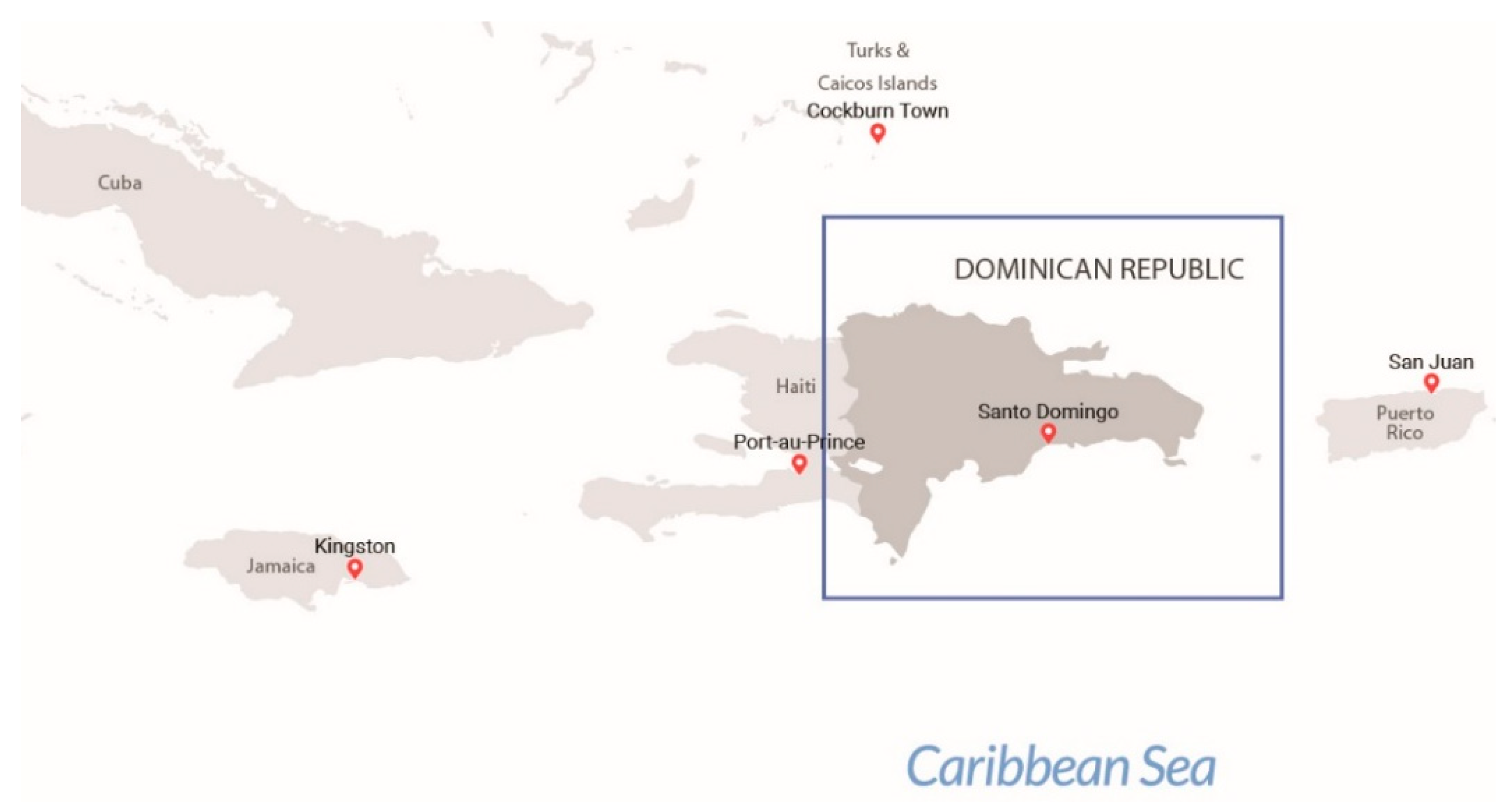
1.2.1. Dominican Republic in Context

The Dominican Republic (DR) has the third largest population among SIDS, with 10.5 million inhabitants and more than 3.3 million citizens living in the capital city of Santo Domingo [14]. The DR is bordered by the Atlantic Ocean in the north, which separates it from the Turks and Caicos Islands; the Mona Passage in the east, which separates it from Puerto Rico; the Caribbean Sea in the south; and the Republic of Haiti in the west (See Figure 1).
The most frequent natural hazards for the Dominican Republic are storms, floods, earthquakes, and wildfires. In 2013, the DR established the Geospatial Information Interinstitutional Team (EIGEO) as a permanent advisory team for the National Emergency Commission [5]. The EIGEO supports emergency mapping operations in case of natural disasters. Map products generated by the EIGEO are used by government officers who coordinate disaster response efforts in the National Emergency Operations Center. These maps are also shared among local response teams. The SINI is a custom clearinghouse system for disaster response purposes [9]. According to Law 208-14, 2014, the National Geographic Institute (IGN, for its Spanish acronym) is a decentralized government agency in charge of the creation and maintenance of any aspect of SDI. It defines the principles to link existing initiatives and resources to reduce redundancy and assure the high quality of information and services provided to users via the SDI. The SDI in the Dominican Republic (IDE-RD, for its Spanish acronym) is oriented to support the decision-making for land and risk management. IDE-RD development is promoted and coordinated by a board of representatives from the IGN and 18 ministries and government agencies. It is mainly financed by the Dominican government and international cooperation agencies, such as World Bank and the Global Facility for Disaster Reduction and Recovery. At present, no official standards for the spatial information domain have been established. There are partnership arrangements among government agencies for IDE-RD development; however, they are based on specific project objectives with a very limited duration. The IDE-RD is accessible at the following address: https://iderd.gob.do/ (accessed on 14 February 2023).

1.2.2. Spatial Data Infrastructure (SDI)

SDI is aimed at enabling and coordinating both the delivery and sharing of geospatial data among multiple stakeholders [1,15]. The SDI Cookbook further expands the SDI definition, “SDI provides a basis for spatial data discovery, evaluation and application for users and providers within all levels of government, commercial sector, non-profit sector, academia and citizens in general”. [16]. SDI components comprise policy, data, technology, people, and standards [16,17,18]. The literature suggests that SDI is built upon multi-sector, multi-organization, long-term partnership(s) to enable data production and sharing among stakeholders [19,20,21,22].
In recent years, researchers have paid great attention to engineering challenges, performance evaluation, or operational status of SDI implementation [18,23,24,25]. Other authors studied the SDI governing system and key processes that enable or constrain SDI governance [15,26]. Nonetheless, other authors emphasize the necessity for more research efforts in the interaction between social and technical issues of SDI development [27,28,29]. In the context of DRM in SIDS, Gómez et al. (2020) [30] work is on the assessment of SDI development and its ability to strengthen the resilience of Caribbean states. More recently, Rosario et al. (2022) [11] worked on the identification of critical factors to enhance SDI performance to facilitate disaster risk management in SIDS.
Even though we cannot predict which data or maps will be required after a natural hazard strikes, datasets are commonly useful to support EMO already existing in the SDI (e.g., satellite imagery, administrative division, etc.) [16]. In terms of spatial data management, sharing, and utilization for disaster and emergency response, SDI has been widely used. For instance, Mansourian et al. (2019) [31] developed a Web-based GIS using SDI to facilitate and improve not only disaster response but also other phases of disaster management in Iran. Other authors focused on the SDI implementation for improving communication between different actors involved in crisis response in the Netherlands [32]. Moreover, Hu et al. (2022) [33] implemented SDI services to facilitate typhoon and triggered flood information for post-flood emergency response and impact assessment in Hainan Province, China. In general, SDI initiatives for disaster and emergency response are still in progress at many levels all around the world, especially in developing countries.

1.2.3. Disaster Risk Management (DRM)

Disaster risk management (DRM) refers to a systematic process of using administrative decisions, and organizations operational skills and capacities to lessen the impacts of natural hazards and related environmental and technological disasters [34,35]. The DRM is related to the management of both risk (ex-ante) and disasters (ex-post) [36]. It consists of a full lifecycle of actions, categorized into four (4) phases. The first phase is mitigation, which comprises all actions designed to reduce the impact of future disasters. The second phase is preparedness, which implies actions taken to reduce the impact of disasters when they are forecast or imminent. The third phase is the response, including emergency actions taken during both the impact of a disaster and the short-term aftermath. The fourth phase is recovery and reconstruction, which implies repairing damage, restoring services, and reconstructing facilities after a disaster has struck [37].

1.2.4. Emergency Mapping Operation (EMO)

The emergency mapping operation (EMO) refers to the creation of maps, geo-information products, and spatial analyses dedicated to providing situational awareness, emergency management, and immediate crisis information for the response. It deals with the extraction of reference (pre-event) and crisis (post-event) geographic information/data [38]. The EMO is aimed at delivery information and service to support the immediate emergency response phase [39]. It facilitates information for the provision of emergency services and public assistance during or immediately after a disaster [3]. In general, EMO can be described as an integral part of the DRM actions, as they contribute to the preparedness, response, and recovery and reconstruction phases of the DRM lifecycle.

1.2.5. Emergency Mapping Team (EMT)

The EMT refers to a collaborative group of mapping specialists, often voluntary, to support decision-makers in defining and sharing a common operational picture (COP) regarding the status of damage and disaster response activities [40,41]. The COP refers to a single dissemination of critical information regarding the status of damages and disaster response activities, thus enabling effective decision-making, coordination, and integration between emergency response organizations [6,42]. EMT operations are focused on creating and distributing disaster-related maps (including reference, operational, and statistical maps). It also deals with sharing geospatial data generated during the response period and delivery of location-based services [43,44]. For instance, EMT initiatives led by Google and Open Street Map have contributed to connecting people and delivering real-time spatial information to support relief efforts and improving alerts for response around the world.
As shown in Figure 2, the EMTs workflow begins by gathering information about the needs and general affairs for generating and sharing a COP of the impacted communities. Then, it proceeds to collect, organize, analyze, and process information from different sources. The process follows with the creation and sharing of map products and services to meet different stakeholders’ applications, mainly emergency command centers, local governments, and the general public. As time progresses, the EMT continuously updates all geospatial resources to meet stakeholders’ needs [3,9,41,45].
In the Dominican Republic context, the Inter-Institutional Geospatial Information Team (EIGEO) is a permanent government unit of the National Emergency Commission, in charge of executing the emergency mapping team (EMT) tasks and operations. It was officially established in 2013. The EIGEO mission is to support decision-making in the phases of disaster mitigation, preparedness, response, and recovery. The EIGEO brings together 14 organizations, including ministries and technical governmental agencies: the Ministry of the Armed Forces; the Ministry of Economy, Planning and Development; the Ministry of the Environment and Natural Resources; the Ministry of Agriculture; the Ministry of Public Health and Social Assistance; the Ministry of Public Works and Communications; the National Office of Civil Defense; the Emergency Operations Center; the National Office of Meteorology; the Autonomous University of Santo Domingo (National Seismological Center and University Geographic Institute); the National Institute of Hydraulic Resources; the National Geological Survey; the Military Cartographic Institute; and the National Bureau of Statistics [5]. The EIGEO workforce is based on a memorandum of understanding among the stakeholders to ensure effectiveness in the generation of geospatial information for decision-making in case of natural or anthropogenic disasters. The EIGEO consists of about 17 active members, including a chief coordinator and a technical team with informatics, GIS, and database and programming professionals.

1.2.6. Multi-Actor Multi-Criteria Analysis (MAMCA)

The MAMCA research method is especially suitable for dealing with multiple stakeholder criteria within an evaluating framework, thus enabling clear assessment per stakeholder [8]. The MAMCA methodology was initially developed to support the decision-making process for the transportation sector [46]. Nonetheless, this methodology has been applied to the evaluation of different development alternatives for SDI [8,47]. Figure 3 presents the main steps of the MAMCA methodology.
As shown in Figure 3, the MAMCA methodology comprises seven general steps, following Macharis et al. (2009) [12]: Step (1) Problem definition and building a set of alternatives. The main purpose is to determine which alternatives will be evaluated. The set of alternatives is defined with the support of key stakeholders.; Step (2) Stakeholder analysis. The main task is identifying the main stakeholders and their objectives.; Step (3) Building criteria and weights set. Stakeholders’ objectives are translated into criteria and each criterion is given a weight that reflects how important that objective is to stakeholders.; Step (4) Criteria, indicators, and measurement methods. The task is linking one or more measurable indicators to each criterion.; Step (5) Overall analysis and ranking. Indicators identified in the previous step are used to evaluate the different alternatives according to the different criteria.; Step (6) Results. A comparison of different strategic alternatives are analyzed for each stakeholder. Step (7) Implementation. The definition of implementation paths is proposed for each stakeholder.

2. Materials and Methods

This section presents the methodology used to assess different stakeholders’ perspectives and their criteria, which can impact alternative scenarios for SDI implementation to facilitate EMO in the Dominican Republic.
To fulfil the purpose of this research, a combination of research methods are used. The research uses study case and MAMCA methodology to investigate how to implement a SDI to facilitate EMO in the DR. SDI development scenarios will be analyzed based on a multi-disciplinary approach which confirms both multidimensional and multifaceted characteristics of a SDI [48]. The goal is to find an answer to the following research question: How to implement an SDI to facilitate EMO in the DR? Since this study’s purpose is too broad, an exploratory case study seems to be the most appropriate approach for this research. A case study research method is an empirical inquiry that investigates a contemporary phenomenon within its real-life context, especially when boundaries between the phenomenon and its context are not evident [49].
SDI implementation only takes place in a specific context, i.e., tailored for an administrative level [50] or designed to meet certain objectives [51]. Furthermore, emergency mapping operations are also driven by a specific context, such as the type and extent of disasters, and the availability of geospatial resources [40]. Therefore, for practical reasons, a case study, along with the MAMCA method, was used to gain an understanding of multiple stakeholders’ and experts’ demands and requirements on how different development scenarios for SDI implementation can enable EMO.

2.1. Study Case Selection
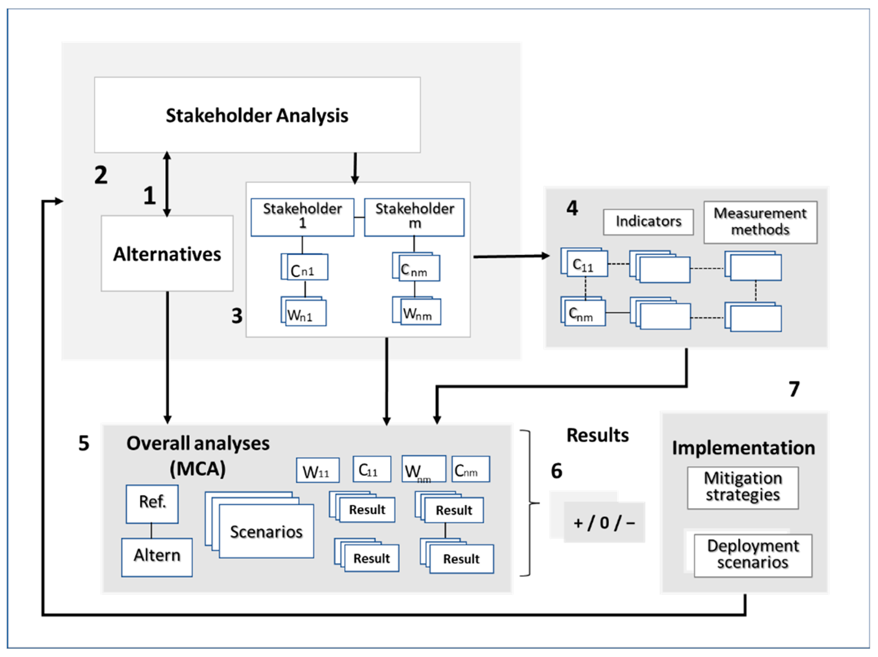
In this research, we purposively selected the DR as a single study case, which is a good representation of a SIDS located in one of the most disaster-prone regions in the world. The DR was also selected based on three criteria: (1) existing SDI initiative [52], (2) accumulated experience with EMO, and (3) a variety of characteristics including population and major natural hazards [14,53]. The unit of analysis for this case study is the SDI. The authors have experience working with, and access to, leading organizations managing geospatial and disaster-related activities in DR.

2.2. MAMCA Method

In this research, a cross-sectional online MAMCA survey was administered, targeted to all key stakeholder groups involved in SDI development and EMO in the DR. This survey was built by using MAMCA Web software, developed by Mobility, Logistics and Automotive Technology Research Centre, Free University of Brussels [54]. This MAMCA survey aimed at capturing and understanding stakeholders’ perspectives on different criteria and alternative scenarios for a successful SDI implementation to facilitate EMO. As any multi-criteria decision analysis (MCDA) techniques can be used to assess the different alternatives scenarios for SDI implementation (such as TOPSIS, SAW, ELECTRE, etc.) [55,56], herein, we made use of the Analytical Hierarchy Process method (AHP). The AHP allows us to take advantage of the graphical support necessary to include and show the stakeholders’ criteria, and uncovers their points of view regarding each scenario for SDI implementation [8].
Virtual and on-site workshops were organized per stakeholder group to present and discuss both aim and methodology used in this survey research. The invitation for the survey was sent by e-mail to all participants. The survey, along with workshop sessions, was carried out from April to June 2022. The following are the general steps of the MAMCA method used in this research, namely:
  • Step (1) Definition of alternative scenarios. At first, a literature review was carried out to identify an initial set of scenarios for SDI implementation. Then, a set of meetings with senior and managerial personnel (experts) with significant experience in GIS, SDI, and EMO were held to validate selected scenarios customization for SDI implementation to facilitate EMO in the DR.
  • Step (2) Stakeholder analysis. The chief coordinator of SINI was subject to a semi-structured interview to identify key stakeholder groups involved in SDI development and EMO in the DR. Four main stakeholder groups were defined, in which the considerations of each stakeholder group had the same level of importance as all others.
  • Step (3) Criteria and weights. A set of criteria and their corresponding weights were defined. The definition of an initial list of criteria was based on comprehensive research on stakeholder-based assessment framework applied to evaluate development scenarios for SDI [8]. A set of interviews with senior professionals from each stakeholder group were conducted to revise the initial list of criteria and validate a final set of criteria per each stakeholder group. Each set of criteria aimed at representing the objectives and purposes of each selected stakeholder group toward further development of SDI to facilitate EMO in DR. The MAMCA web survey was used to ask all participants to allocate 100 points to weigh the importance of each criterion regarding SDI implementation per individual stakeholder group. The final weights were calculated by taking the mean of the individual weights for each participant belonging to the same stakeholder group.
  • Step (4) Set of criteria and indicators. The task was aimed at linking each stakeholder criterion to one or more measurable indicators. This helped the analyst in assessing the performance of every single criterion regarding each alternative scenario.
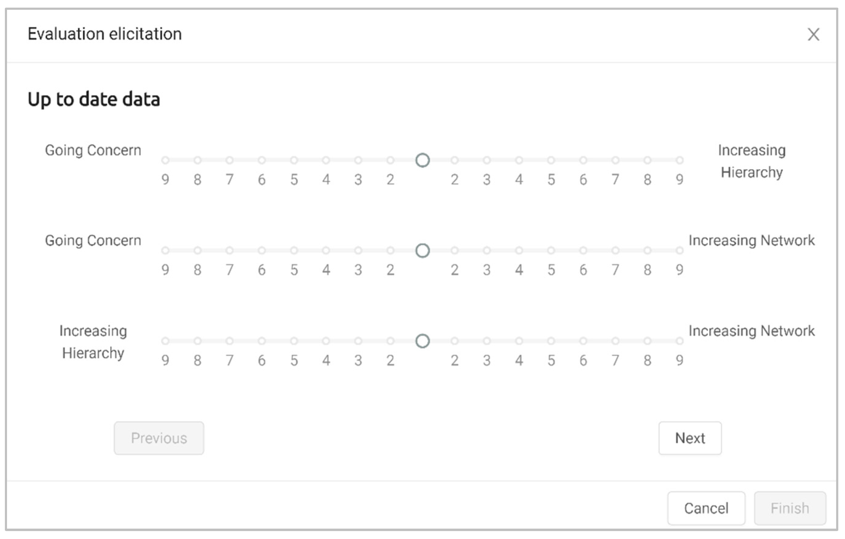
  • Step (5) Overall analysis and ranking. A pairwise comparison was performed through Analytical Hierarchy Process (AHP), using a 1–9 comparison scale (9-to-1-to-9 scale). It evaluates each criterion‘s performance regarding the different alternative scenarios for SDI implementation [13] (see Table 1). The MAMCA web survey was also used to ask participants to perform pairwise comparisons for each criterion. The AHP method was used to determine the final ranking (performance) of the alternative scenarios for SDI implementation followed Saaty (1990) [57].
  • Steps (6) and (7) Results and implementation. The comparison of different alternative scenarios was analyzed for each stakeholder group. Based on the results of this analysis, the definition of implementation paths was proposed for each stakeholder. Findings were further analyzed at an informal discussion session at the National Emergency Commission of the DR. Members of SINI (three), EIGEO (two), NGOs (two), and the National Geographic Institute (two) attended this session. Feedback information was then incorporated into the analysis.

3. Results

In this study, we aimed to assess how the implementation of an SDI can facilitate emergency mapping operations in the Dominican Republic. In this section, the most important survey results are presented and discussed. At first, we presented the definition of chosen scenarios for SDI implementation, followed by stakeholders’ analysis and their definition of criteria and weights. Then, the outputs from assessing different alternative scenarios for SDI implementation are described and discussed.

3.1. Step (1) Definition of Alternative Scenarios

In this first step, a set of scenarios for further development of SDI in the Dominican Republic was defined. The definition of this set of scenarios was built upon a literature review and consultations with five experts from SDI and DRM domains. Previous research has assessed five different scenarios (going concern, increasing hierarchy, hierarchy/market, decreasing hierarchy and increasing network, and decreasing hierarchy and increasing market) in a developed-country setting in Flanders [8]. In contrast, in this study, we purposely selected only three for assessing SDI implementation in the DR context.
The three selected scenarios are the following: going concern, increasing hierarchy, and increasing network. The selection of these three scenarios was based on three criteria: (1) feedback information from local experts, (2) the fact that SDI implementation in DR is still in an early stage, and (3) its constraints as highly prone-disaster SIDS in the Caribbean region [58].
The going concern alternative is our first scenario, which reflects the current situation of SDI development. It sets the baseline scenario for alternatives comparison (See Table 2). The second scenario is increasing hierarchy. This scenario is defined by an increase in the hierarchical framework, with an additional legal basis for SDI development, led by the government as a top-down rule-maker and main source of funding. The third scenario is increasing network. This scenario reflects an increase in the network coordination mechanisms among stakeholders. It enables higher market power to all stakeholders, and lower government responsibility for funding SDI development. Based on these characteristics of the selected scenarios, we defined alternatives for decision-making problems as different development paths which SDI should go through to facilitate EMO in the DR.

3.2. Step (2) Stakeholder Analysis

Stakeholder analysis is a crucial step to properly capture decision-making problems and the range of stakeholders to be included in the decision process [59]. In this study, relevant technical and managerial personnel actively involved in EMO when there is a disaster, along with senior GIS professionals with expertise in the SDI field, were recruited as participants. A total of twenty-five (25) participants were identified and divided into four main stakeholder groups, following Kerle and Hoffman (2013) [40], namely:
  • Government sector (5)
  • Emergency mapping team (7)
  • Private sector (8)
  • Academia (5)
All four selected stakeholder groups play a key role in data collection, processing, analysis, visualization, and sharing for SDI development, as well as EMO, in the Dominican Republic. The government group comprises managerial personnel from official organizations (users/producers) and mapping agencies. They have a lead role in generating, integrating, mapping, updating, and delivery of core spatial datasets and services for SDI development. EMT group includes technicians from SINI and EIGEO teams. They are responsible for generating and sharing thematic maps and services in case of disasters. The private sector group comprises senior professionals from consulting firms and surveying enterprises. They deliver consulting services and technological support in the geospatial data acquisition and the development of GIS applications for emergency response agencies. The academia group comprises researchers from Dominican universities and research centers. They play a key role in the analysis of geographic information and deliver best practices and trainings for emergency response and SDI issues.

3.3. Step (3) Set of Criteria and Weights

An initial list of 15 criteria was built upon a comprehensive literature review on performance indicators [18,23,60], assessment approaches for SDI implementation [8,47,61,62], and users’ requirements for EMT operations [6,11]. This initial list was sent by e-mail to each stakeholder group for validation. They selected and validated a final list of 10 criteria (See Table 3).
Afterward, each stakeholder group was required to redefine their own set of criteria, followed by their assessment (using a 100-point allocation) of the weight they attributed to each criterion. Weights were calculated by way of the mean of individual weights by each participant per stakeholder group. Table 4 shows the final list of validated criteria and their corresponding weights per stakeholder group.
In general, Table 4 shows that all stakeholder groups have similar ideas regarding what criteria they consider most important for SDI implementation. Overall, up-to-date data is considered an important criterion across all stakeholder groups. This criterion refers to the need for spatial data to be frequently updated to reflect the current situation throughout the disaster risk management lifecycle.
Public-private partnerships and effective communication were also considered highly important criteria by most stakeholders, except for academia. Our results also show that some criteria were exclusive to certain stakeholder groups. For instance, open data format, availability of trainings, and SDI awareness were criteria exclusive to the government, private sector, and academia, respectively.
A more specific analysis can be obtained by looking at individual stakeholder groups. For government sector, our analysis revealed that up-to-date data (32%) and effective communication (20%) are the most important criteria. However, users’ involvement (13%) has the lowest weight for this sector. This can be explained by the fact that SDI in the Dominican Republic is mature enough at the operational level [18], but there are still some components to improve (e.g., users’ involvement and availability of open data formats).
For the EMT group, data standardization (28%) and up-to-date data (24%) were the most important criteria. Other authors also agree with this result, stating that the standards for data capture methods, metadata, quality, maintenance, symbology, map products, and access network are key requirements for emergency mapping workflow [10].
Not surprisingly, the ranking for the private sector shows a focus on funding (25%) as the most important criterion. As there is an increase in the demand for current and more detailed information on impacted communities, more funding will be required to support data capture, processing, and sharing. The second and third most important criteria for the private sector were up-to-date data (19%) and training availability (15%). These results can be explained by the fact that current funding might not be enough to enable trainings on mapping techniques and to engage more users in the EMO processes [11].
Results show that the most important criterion for the academia group is data standardization (22%), followed by the institutional framework, funding, and up-to-date data, each at 20%. This stakeholder group deems SDI awareness (18%) as important. This can be explained through the necessity to raise awareness about the strategic value that SDI can bring to the table of decision-makers, in case of disasters [19,63,64]. It is also needed to spread the contribution of SDI development to the proper functioning of EMO, disaster risk management, and society.

3.4. Step (4) and (5) Indicators and AHP Comparison

During this step, we first proceeded to operationalize the criteria list by using indicators. We considered that these indicators should be SMART, which stands for Specific, Measurable, Attainable, Relevant, and Trackable [65]. A set of key indicators was compiled for each criterion to evaluate the performance of each scenario for SDI implementation regarding each criterion. For instance, the indicator for the criterion “users’ involvement” is the “number of users involved in the SDI implementation”. Therefore, this indicator allows an assessment regarding users’ involvement in each of the alternatives. Table 5 shows the criteria list, indicators, and measurement methods. For evaluation of the alternative, we applied AHP comparison, using a 1–9 comparison scale (9-to-1-to-9 scale). Specifically, each participant per stakeholder group was asked to rate their perceived impact of up-to-date data on all alternative scenarios for SDI implementation (see Figure 4).

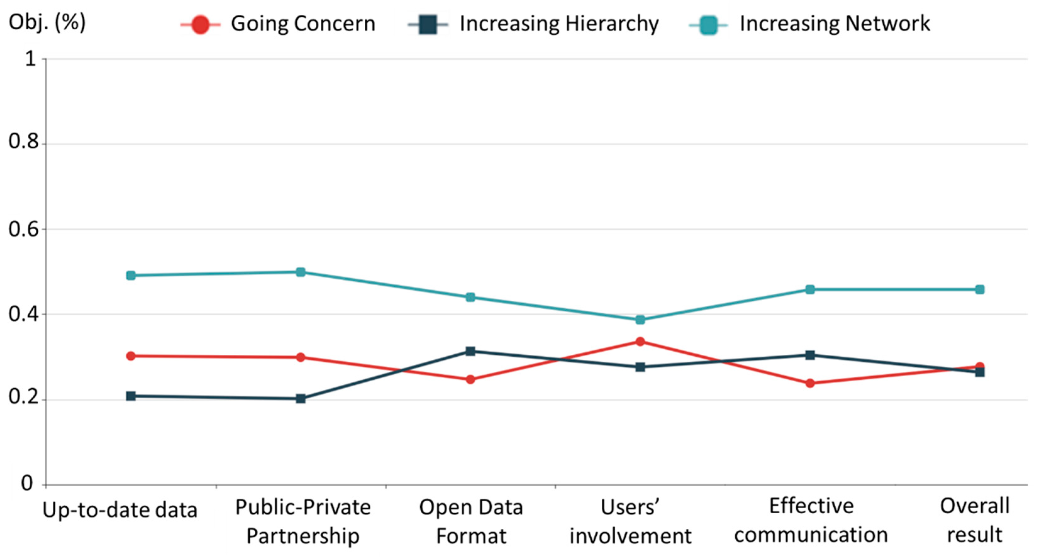
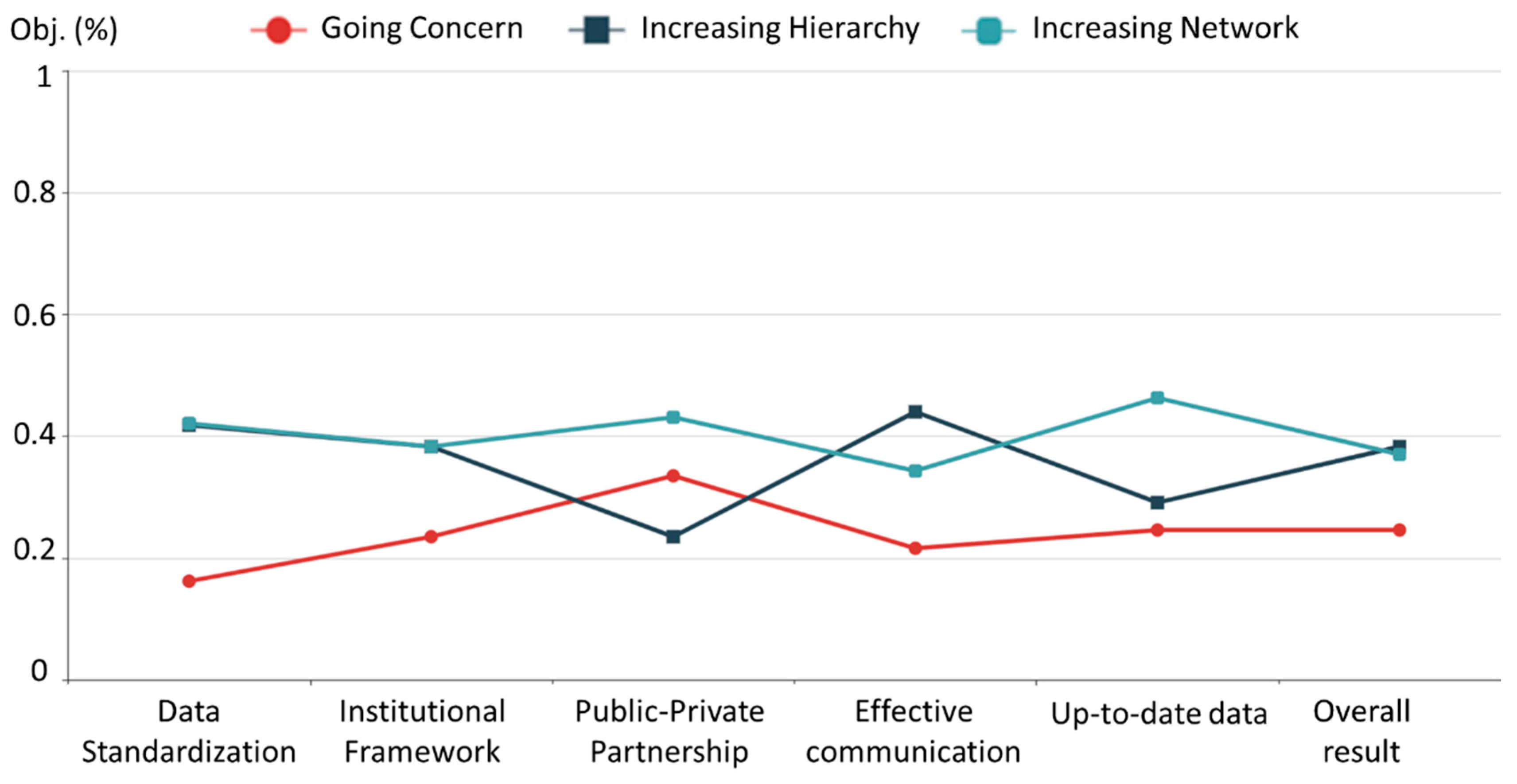
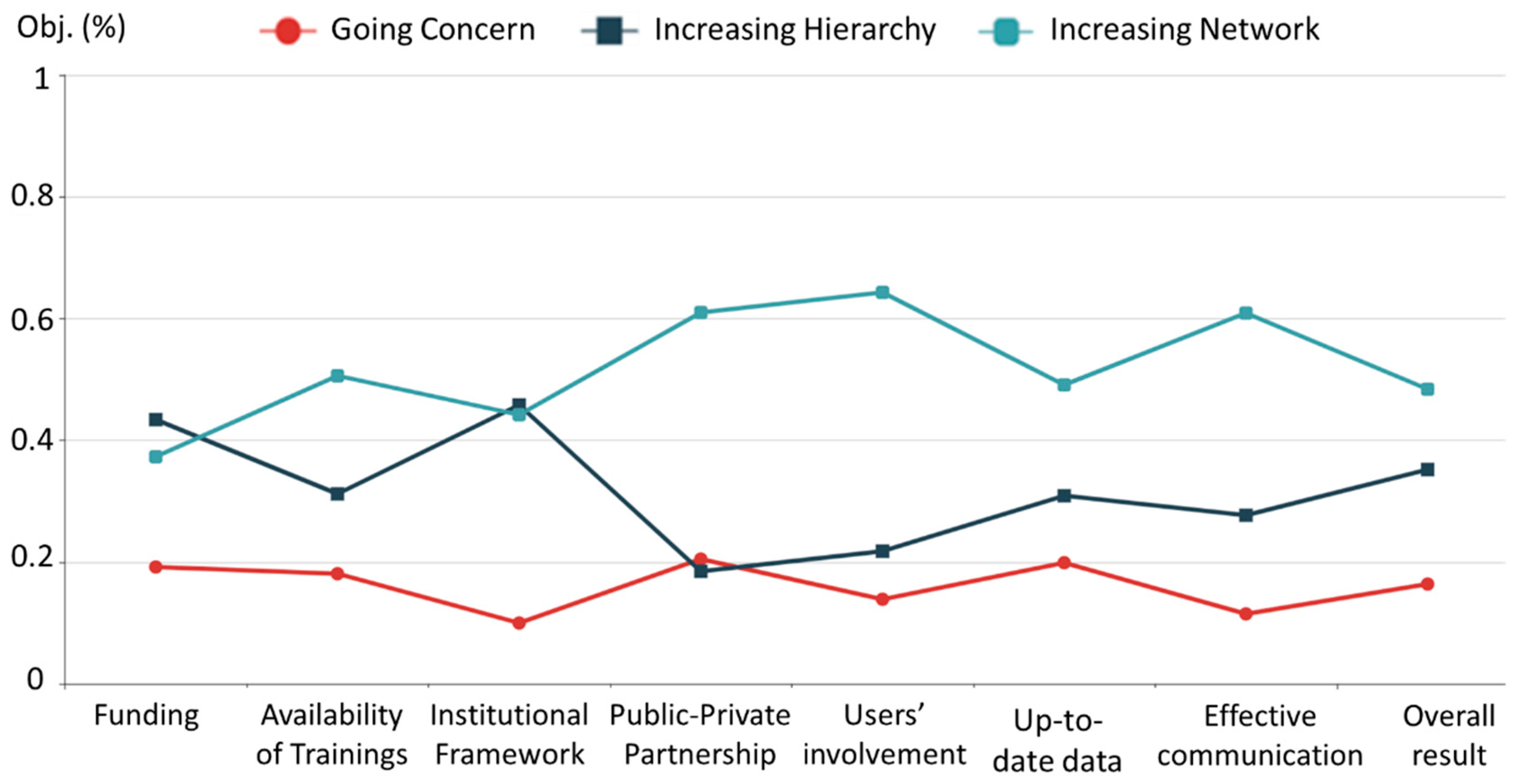
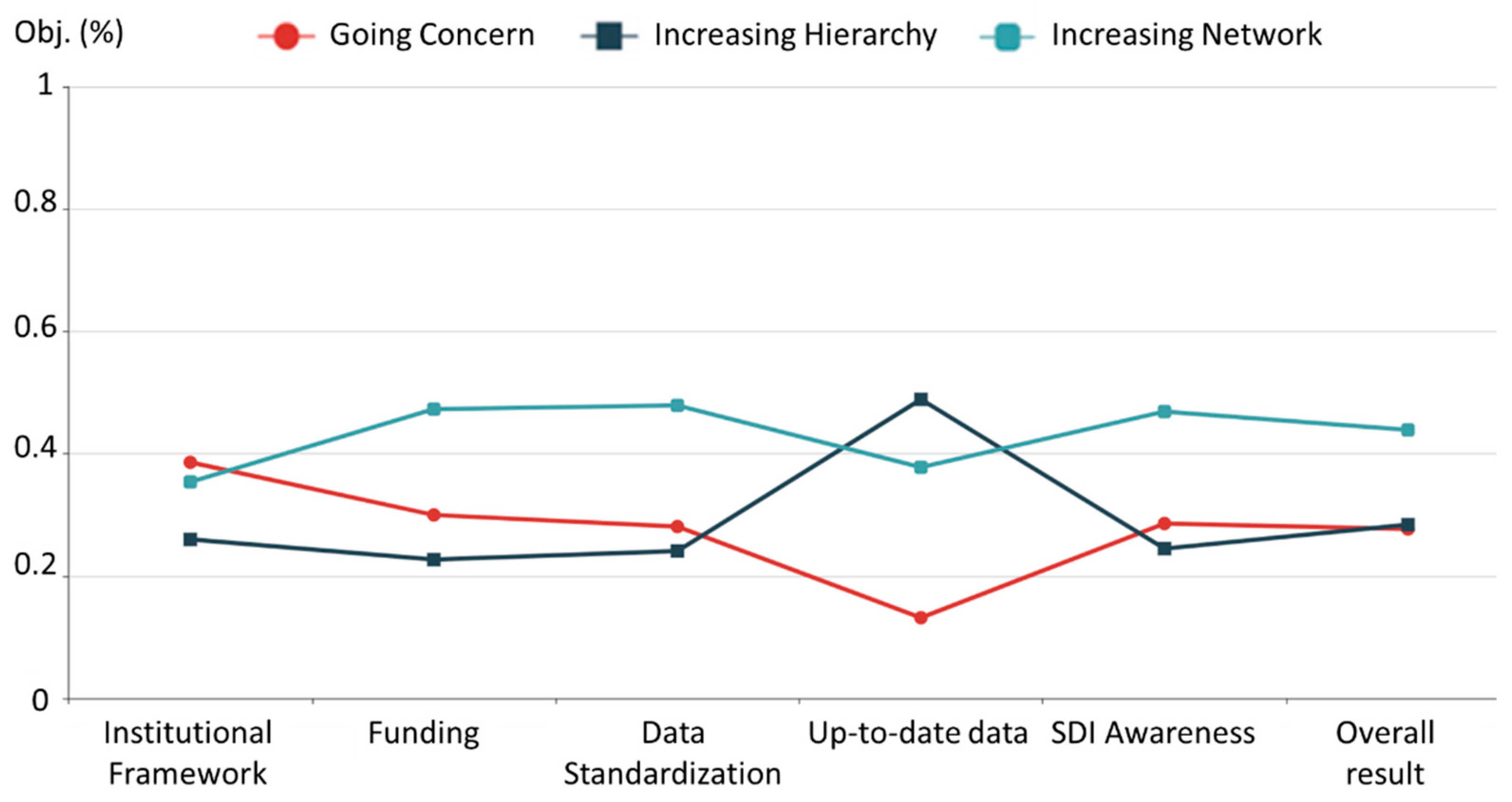
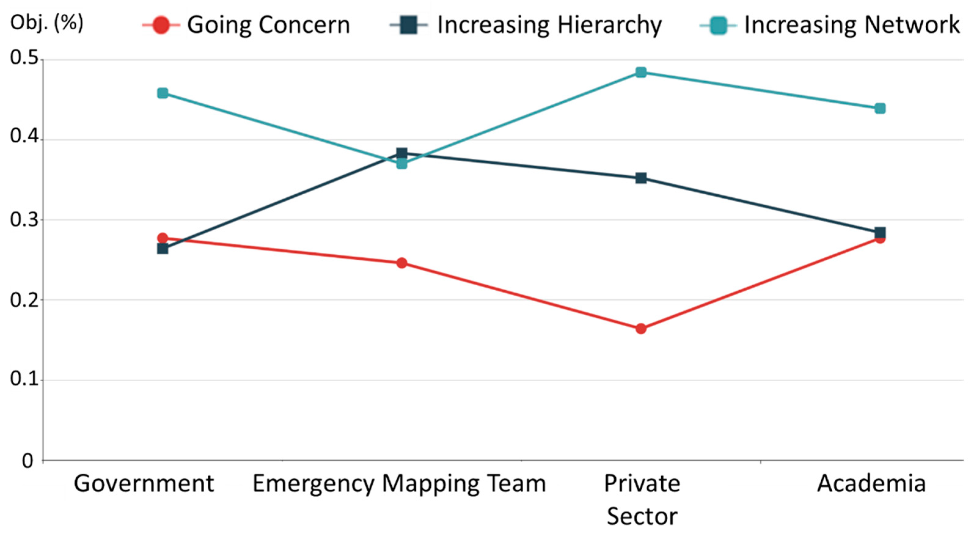
3.5. Steps (6) and (7): Evaluation and Multiactor View

In this final step, a score for each scenario and stakeholder group was calculated. The score was computed based on criteria weights (Step 2) and pairwise comparisons (Step 5). The remainder of the subsection presents evaluation results using figures, as seen in Figure 5, Figure 6, Figure 7, Figure 8 and Figure 9. They show the results for each stakeholder group: government, private sector, emergency mapping team, academia, and the multi-actor view of the evaluation, respectively. Each figure has two axes. The horizontal axis shows participating stakeholder groups, while the vertical axis presents the perceived score for scenarios through AHP evaluation.
As shown in Figure 5, our results for the government sector reveal that ‘Increasing Network’ (46%) is the most preferred scenario. For this scenario, the criteria with the highest score are public-private partnership and up-to-date data, each at 49%. According to this result, the government sector might be willing to strengthen its position to facilitate cross-sector collaborations in the SDI framework to access new and updated data and technologies for emergency mapping operations.
It is noteworthy that this stakeholder group has similar scores for ‘Going Concern’ (28%) and ‘Increasing Hierarchy’ (26%) scenarios. However, their preferences on the most important criteria for each of these scenarios are different. For the ‘Going Concern’ scenario, users’ involvement (34%), and up-to-date data (30%) are the most important criteria. This might be explained by the current necessity to improve the participation of other relevant players, like the private sector, academia, and NGOs, in the SDI development. It is required to enable more users to manage spatial data efficiently and effectively for EMO. However, for ‘Increasing Hierarchy’, open data format (31%), and effective communication (30%) are the most important criteria. Other authors also highlighted the key role of effective communication among all stakeholders involved in emergency and crisis management [9,44,66,67].
As shown in Figure 6, our results for the EMT group indicate that the ‘Increasing Hierarchy’ (38%) is the most preferred scenario for SDI implementation, closely followed by the ‘Increasing Network’ (37%) scenario. For the ‘Going Concern’ scenario, the EMT group rates public-private partnership (33%) and up-to-date data (25%) as the most important criteria. Herein, for the ‘Increasing Hierarchy’ scenario, effective communication (44%) and data standardization (42%) criteria have top preference. For the ‘Increasing Hierarchy’ scenario, effective communication (44%) and data standardization (42%) criteria have top preferences. Up-to-date data (46%), public-private partnerships (43%), and data standardization (42%) are the most important criteria for the ‘Increasing Network’ scenario. Though almost all geospatial data for EMO is in digital format, standardization, and harmonization are still important issues to tackle, especially to respond to emergency mapping tasks in the Dominican Republic [10,11].
The private sector has a specific view on SDI implementation. Figure 7 shows their view, where ‘Increasing Network’ (48%) has the highest preference. For this scenario, users’ involvement (64%) is the most influential criterion, followed by public-private partnerships and effective communication, each at 61%. This result reflects the desire of this sector to increase its contribution by providing geospatial information and related services for EMO and DRM.
For the private sector, ‘Increasing Hierarchy’ (35%) has the second highest score among scenarios. Its high overall performance is due to its performance regarding institutional framework (46%), and funding (43%) criteria. These criteria both have similar performances for the top two preferred scenarios. The ‘Going Concern’ (16%) scenario has received low scores from all participants, which might mean that a change to either the ‘Increasing Network’ or the ‘Increasing Hierarchy’ scenario is deemed positive.
Evaluation results for the academia group are shown in Figure 8. For this stakeholder, the top alternative is ‘Increasing Network’ (44%). This result could be expected since this alternative enables their research to be available and accessible to all parties involved in EMO activities. The other two alternatives, ‘Increasing Hierarchy’ and ‘Going Concern’, seem less interesting for academia stakeholders, each at 28%. Herein, results also show that this stakeholder and the private sector are the only ones with a high rate for more funding availability to sustain future development of SDI that will enable EMO. The limited funding allocations for SDI development demand more legal and regulatory policies to promote public-private partnerships to increase the production and sharing of data, technologies, and services to strengthen EMO.
Figure 9 shows the overall results (multi-actor view) of our evaluation. Our results indicate that the ‘Increasing Network’ scenario has the top preference across all stakeholder groups, except for EMT. This group rated the ‘Increasing Hierarchy’ scenario as important as the ‘Increasing Network’. In general, our results reveal there is a strong desire to move to a more collaborative and well-coordinated inter-organizational network with the participation of all stakeholders involved in EMO and response efforts, namely government agencies, EMT, academia, and the private sector.
The second most preferred scenario was ‘Increasing Hierarchy’, except for the government group. This stakeholder has a greater preference for the ‘Going-Concern’ (27%) scenario than the ‘Increasing Hierarchy’ (26%) scenario.
Finally, our results also highlighted that EMT gave the ‘Increasing Hierarchy’ (38%) scenario the highest score among all stakeholders. This might be explained by their willingness to strengthen their own existing geospatial information network, which is the National Integrated Information System (SINI).

4. Conclusions

Research on the optimal scenario for SDI implementation to facilitate emergency mapping operations (EMO) spans a broad range of technical, social, and institutional issues, including multiple stakeholders’ points of view. Therefore, this research has been focused on different stakeholders’ perspectives along with their underlying criteria to evaluate how to implement an SDI to facilitate EMO in the Dominican Republic.
In this paper, we report on the adaptation of the Multi-Actor Multi-Criteria Analysis (MAMCA) research methodology to obtain different points of view from four key stakeholder groups for custom SDI implementation to enable EMO in the Dominican Republic. At least five (5) representatives of each stakeholder group participated in the study, namely: the government (5), private sector (7), emergency mapping team (8), and academia (5). These stakeholder groups continuously collaborate on data collection, processing, analysis, visualization, and sharing for SDI development and EMO in the Dominican Republic.
For practical reasons, three alternative scenarios were proposed for the evaluation: ‘Going Concern’, ‘Increasing Hierarchy’, and ‘Increasing Network’. The adaptation of the MAMCA methodology allowed the integration of explicit opinions of the different key stakeholders regarding different scenarios and, thus, answered the research question of, “How to implement a SDI to facilitate EMO in the Dominican Republic?”
Even though it is almost impossible to achieve perfect consensus on how to implement a single alternative scenario for SDI development that every stakeholder involved in EMO agrees with, our overall results (multi-actor view) revealed that most stakeholders have a greater preference for the ‘Increasing Network’ scenario. In contrast, the EMT group particularly perceived the ‘Increasing Hierarchy’ scenario to be as important as the ‘Increasing Network’ scenario. The second most preferred scenario was ‘Increasing Hierarchy’. However, for practical reasons, the combination of the ‘Increasing Hierarchy’ and ‘Increasing Network’ scenarios could also be feasible for SDI implementation in realm SIDS settings. The application of the mixed strategy might depend on the characteristics of the country, in which there should be considered relevant factors that define the context, including SDI maturity level, political vision, availability of funding, and skilled staff, among others. In a general sense, the mixed strategy should begin with the application of the ‘Increasing Hierarchy’ scenario as a first step toward SDI implementation, followed by the adaptation of the ‘Increasing Network’ scenario.
Our findings also stress the necessity of building more collaborative and well-coordinated interorganizational networks through SDI to enable timely decision-making in case of disasters. The integration of SDI resources from different institutions and spatially distributed stakeholders can contribute to reaching EMO goals for supporting disaster response and relief efforts.
Regarding the criteria defined for each scenario, our results indicated that up-to-date data is the most relevant across all stakeholder groups. Public-private partnerships are another relevant criterion. They might be useful to reduce cost and time and increase the availability of valuable existing and/or new geospatial information and technology to support emergency mapping operations. Accordingly, it is remarked that existing policies to promote public-private partnerships might facilitate the availability of more funding and resources for the generation, updating, and sharing of data, technologies, and services to strengthen EMO.
Our study also reveals that a solid institutional framework and effective communication among all stakeholders are key criteria for delivering better information and services to support EMO in the Dominican Republic. Moreover, our findings point to data standardization as one cornerstone criterion for SDI development to support emergency mapping operations. Herein, the implementation of international standards like the Open Geospatial Consortium (OGC) standards, ISO standards, or INSPIRE in Europe, could ensure openness and flexibility to enable the exchange of geospatial metadata, data, and services in a rapid-changing and distributed environment [18,63]. In particular, the adaptation of the Latin American Metadata Profile (LAMP) and standards for open data file formats are also critical for enhancing spatial data integration and sharing through the SDI. The establishment of standardized and interoperable SDI services increases common understanding and effectiveness across all stakeholders involved in disaster management activities [3,40,68,69].
In this study, the applied methodology provides a deeper understanding of the perspective of each stakeholder group, facilitating the comparison of the different objectives with one another. For instance, our findings show that the EMT sector prefers the generation and sharing of up-to-date data, the establishment of more public-private partnerships, and data standardization for further development of SDI to enable EMO. However, the private sector indicates that the future development of SDI in the Dominican Republic could be based on more users’ involvement in EMO tasks, increasing public-private partnerships, effective communication among stakeholders, and more training availability. The academia sector has a specific preference for the necessity of increasing SDI awareness among the stakeholders involved in the EMO, while the private sector has a particular preference for developing more training to facilitate the integration of SDI and EMO in the Dominican Republic. In summary, the utilization of SDI can potentially benefit EMO by achieving more collaborative interagency networks, real-time coordination, communication, and knowledge transfer, and enabling more users’ involvement in the EMO workflows and procedures.
There are some limitations to our research approach. In our study, the MAMCA method adaptation using Web software required a license from the Mobility, Logistics, and Automotive Technology Research Centre at Vrije Universiteit Brussel. Nonetheless, this Web software also provides a limited free version. This approach also needs well-planned coordination for workshops to explain to each stakeholder group, the Web software interface and the goals of the study. This preparatory step is recommended before proceeding with the data collection to ensure clarity and validity.
The ability to collect and analyze data on perspectives from the same stakeholder groups in other SIDS and compare them to our survey results could have significantly improved our conclusions. We also have a special interest in differentiating the weights of each stakeholder group depending on criteria, such as expertise, experience, previous performance, and level of involvement in emergency mapping operations and SDI development, among others. However, the lack of existing literature on SDI to facilitate emergency mapping operations in developing countries and the need for relevant information on the topic justify the approach.
For future research, we would extend our focus to explore the development of communication and collaboration platforms and tools that enable real-time information sharing and decision-making among stakeholders during disasters. Another area of research would focus on exploring ways to strengthen public-private partnerships for SDI development, for example, by evaluating alternative policies and frameworks that incentivize private sector participation in EMO activities, such as data collection, processing, and analysis. Further work could also explore the use and standardization of emerging technologies, such as artificial intelligence, machine learning, and blockchain, to automate data collection and analysis, facilitate decision-making, and ensure data security and privacy for enhancing SDI implementation.
This research might be relevant for the Dominican Republic as well as the scientific community from other SIDS in the Caribbean region and around the world. To the best of our knowledge, this work represents the most comprehensive user-centered study on the evaluation of SDI implementation to facilitate EMO in the Dominican Republic and any other SIDS ever undertaken. Therefore, the results of the MAMCA application offer a road map to generate joint actions among the different parties involved who contribute to implementing a SDI that serves as a framework for EMO during emergency and disaster situations. The results of this study may also be useful for international agencies that are helping SIDS enhance their resilience to respond to disasters. Before embarking on their cooperation tasks, these agencies could first study alternative scenarios, stakeholders’ objectives, and their criteria for SDI implementation to satisfy EMO goals in the SIDS they are going to work for. Our findings also serve as a foundation for building a dynamic and strong SDI to support future Digital Earth vision in SIDS settings.

Author Contributions

The authors’ individual contributions are specified as followed: Conceptualization, Gregorio Rosario Michel, Joep Crompvoets, and María Ester Gonzalez-Campos; methodology, Gregorio Rosario Michel, Joep Crompvoets, María Ester Gonzalez-Campos, and Fernando Manzano Aybar; software, Gregorio Rosario Michel, María Ester Gonzalez-Campos, and Fernando Manzano Aybar; formal analysis, Gregorio Rosario Michel, Joep Crompvoets, María Ester Gonzalez-Campos, and Fernando Manzano Aybar; resources, Gregorio Rosario Michel, Joep Crompvoets, and Fernando Manzano Aybar; writing—original draft preparation, Gregorio Rosario Michel, Joep Crompvoets, María Ester Gonzalez-Campos, and Fernando Manzano Aybar; writing—review and editing, Gregorio Rosario Michel, Joep Crompvoets, María Ester Gonzalez-Campos, and Fernando Manzano Aybar; project administration, Gregorio Rosario Michel; funding acquisition, Gregorio Rosario Michel and Joep Crompvoets. All authors have read and agreed to the published version of the manuscript.

Funding

This research was funded by the Ministry of Higher Education, Science and Technology (MESCYT) of the Dominican Republic and the National Geological Survey of the Dominican Republic, under grant number FONDOCYT 2018-2019-1E3-065.

Data Availability Statement

Data is contained within the article.

Acknowledgments

We wish to acknowledge the contributions to our research, made by: the Inter-Institutional Geospatial Information Team (EIGEO, in Spanish), National Integrated Information System (SINI, in Spanish), and the National Emergency Commission of the Dominican Republic. Additionally, the participants from the academia and private enterprises, for their time and patience in answering our survey questionnaires. We also want to acknowledge the comments of the anonymous reviewers and the editor that helped us improve this research paper. We thank the support of technical and administrative personnel at the National Geological Survey of the Dominican Republic and the Universidad Nacional Pedro Henriquez Ureña (UNPHU). We also want to thank Santiago Muñoz Tapia, Rina Familia, and Claudia Acra Despradel for their encouragement and valuable insights in the development of this research.

Conflicts of Interest

The authors declare no conflict of interest.

References

  1. Crompvoets, J.; Bregt, A.; Rajabifard, A.; Williamson, I. Assessing the worldwide developments of national spatial data clearinghouses. Int. J. Geogr. Inf. Sci. 2004, 18, 665–689. [Google Scholar] [CrossRef]
  2. Schade, S.; Granell, C.; Vancauwenberghe, G.; Keßler, C.; Vandenbroucke, D.; Masser, I.; Gould, M. Geospatial Information Infrastructures BT—Manual of Digital Earth; Guo, H., Goodchild, M.F., Annoni, A., Eds.; Springer: Singapore, 2020; pp. 161–190. [Google Scholar] [CrossRef]
  3. Ajmar, A.; Boccardo, P.; Disabato, F.; Giulio Tonolo, F. Rapid Mapping: Geomatics role and research opportunities. Rend. Lincei Sci. Fis. E Nat. 2015, 26, 63–73. [Google Scholar] [CrossRef]
  4. UN-GGIM. Future Trends in Geospatial Information Management: The Five to Ten Year Vision, 3rd ed.; UN-GGIM: Deqing, China, 2020; Available online: https://ggim.un.org/documents/DRAFT_Future_Trends_report_3rd_edition.pdf (accessed on 12 January 2023).
  5. EIGEO. Presentación Equipo Interinstitucional de Información Geoespacial. 2014. Available online: http://defensacivil.gob.do/ (accessed on 2 February 2023).
  6. Kimura, R.; Munenari, I.; Keiko, T.; Takashi, F.; Haruo, H. Clarifying the Function of the Emergency Mapping Team in order to Allocate the Limited Resources in the Time of 2011 Great East Japan Earthquake. In Proceedings of the TIEMS (The International Emergency Management Society), 2012; pp. 72–78. Available online: https://kimurareo.com/images/2021/07/12TIEMS_Kimura.pdf (accessed on 12 January 2023).
  7. Keiko, T.; Hayashi, H. Geospatial Information Improves the Decision-Making Process during the Disaster Response: The Experience of the Emergency Mapping Team in the 2011 off the Pacific Coast of Tohoku Earthquake Takashi. In Proceedings of the 15th World Conference on Earthquake Engineering, Lisbon, Portugal, 24–28 September 2012; Volume 5. [Google Scholar]
  8. Macharis, C.; Crompvoets, J. A stakeholder-based assessment framework applied to evaluate development scenarios for the spatial data infrastructure for Flanders. Comput. Environ. Urban Syst. 2014, 46, 45–56. [Google Scholar] [CrossRef]
  9. Rosario Michel, G.; Muñoz Tapia, S.; Manzano Aybar, F.; Guzmán Javier, V.; Crompvoets, J. Identifying users’ requirements for emergency mapping team operations in the Dominican Republic. ISPRS Int. J. Geo-Inf. 2020, 9, 165. [Google Scholar] [CrossRef]
  10. Rosario, G.; Aybar, F.M.; Guzmán, L.N.; Calderón, C.V.; Durán, T.J.; Crompvoets, J. Identifying users’ requirements for emergency mapping team operations in small island developing states: Caribbean perspective. ISPRS Int. J. Geo-Inf. 2021, 10, 307. [Google Scholar] [CrossRef]
  11. Rosario Michel, G.; Gonzalez-Campos, M.E.; Manzano Aybar, F.; Jiménez Durán, T.; Crompvoets, J. Identifying critical factors to enhance SDI performance for facilitating disaster risk management in small island developing states. Surv. Rev. 2022, 55, 114–126. [Google Scholar] [CrossRef]
  12. Macharis, C.; De Witte, A.; Ampe, J. The multi-actor, multi-criteria analysis methodology (MAMCA) for the evaluation of transport projects: Theory and practice. J. Adv. Transp. 2009, 43, 183–202. [Google Scholar] [CrossRef]
  13. Saaty, T.L.; Vargas, L.G. Models, methods, concepts & applications of the analytic hierarchy process. In Driven Demand and Operations Management Models; Springer: Berlin/Heidelberg, Germany, 2012. [Google Scholar] [CrossRef]
  14. National Bureau of Statistic. Tu Municipio en Cifras. IX Censo Nacional de Población y Vivienda 2010. 2022. Available online: https://www.one.gob.do/provinciales-y-municipales/tu-municipio-en-cifras (accessed on 10 October 2022).
  15. Sjoukema, J.W.; Samia, J.; Bregt, A.K.; Crompvoets, J. Governance interactions of spatial data infrastructures: An agent-based modelling approach. Int. J. Digit. Earth 2021, 14, 696–713. [Google Scholar] [CrossRef]
  16. GSDI. SDI Cookbook; Technical Working Group Report; Global Spatial Data Infrastructure Association: Gilbertville, IA, USA, 2012; pp. 1–128. Available online: http://gsdiassociation.org/images/publications/cookbooks/SDI_Cookbook_from_Wiki_2012_update.pdf (accessed on 12 January 2023).
  17. Crompvoets, J.; Vancauwenberghe, G.; Ho, S.; Masser, I.; De Vries, W.T. Governance of national spatial data infrastructures in Europe. Int. J. Spat. Data Infrastruct. Res. 2018, 13, 253–285. [Google Scholar] [CrossRef]
  18. Gómez, P.M.; García, M.P.; Seco, G.G.; Santiago, A.R.; Johnson, C.T. The Americas’ spatial data infrastructure. ISPRS Int. J. Geo-Inf. 2019, 8, 432. [Google Scholar] [CrossRef]
  19. Mansourian, A.; Rajabifardb, A.; Zoeja, M.J.V. Sdi conceptual modeling for disaster management. Service and Application of Spatial Data Infrastructure. In Proceedings of the International Society for Photogrammetry and Remote Sensing, Hangzhou, China, 14–16 October 2005; pp. 125–130. [Google Scholar]
  20. Onsrud, H.; Poore, B.; Rugg, R.; Taupier, R.; Wiggins, L. The Future of the Spatial Information Infrastructure. In A Research Agenda for Geographic Information Science; CRC Press: Boca Raton, FL, USA, 2004; pp. 225–255. [Google Scholar]
  21. Coleman, D.J.; Rajabifard, A.; Kolodziej, K.W. Expanding the SDI environment: Comparing current spatial data infrastructure with emerging indoor location-based services. Int. J. Digit. Earth 2016, 9, 629–647. [Google Scholar] [CrossRef]
  22. Idrizi, B. General Conditions of Spatial Data Infrastructures. Int. J. Nat. Eng. Sci. 2019, 12, 57–62. [Google Scholar]
  23. Giff, G.; Crompvoets, J. Performance Indicators a tool to Support Spatial Data Infrastructure assessment. Comput. Environ. Urban Syst. 2008, 32, 365–376. [Google Scholar] [CrossRef]
  24. Mulder, A.; Wiersma, G.; Van Loenen, B. Status of National Open Spatial Data Infrastructures: A Comparison Across Continents. Int. J. Spat. Data Infrastruct. 2020, 15, 1–29. [Google Scholar] [CrossRef]
  25. Nedović-Budić, Z.; Crompvoets, J.; Georgiadou, Y. Spatial Data Infrastructures in Context: North and South; Nedović-Budić, Z., Crompvoets, J., Georgiadou, Y., Eds.; CRC Press: Boca Raton, FL, USA, 2011. [Google Scholar]
  26. Sjoukema, J.; Bregt, A.K.; Crompvoets, J. Understanding Governance Dynamics: The Governing. Int. J. Spat. Data Infrastruct. Res. 2020, 15, 1–35. [Google Scholar] [CrossRef]
  27. Crompvoets, J.; Rajabifard, A.; van Loenen, B.; Delgado-Fenández, T. Future directions for Spatial Data Infrastructure Assessment. In A Multi-View Framework to Assess SDIs; The Melbourne University Press: Melbourne, Australia, 2008; pp. 385–397. [Google Scholar]
  28. Gourmelon, F.; Noucher, M.; Georis-Creuseveau, J.; Amelot, X.; Gautreau, P.; Le Campion, G.; Maulpoix, A.; Pierson, J.; Pissoat, O.; Rouan, M. An integrated conceptual framework for SDI research: Experiences from French case studies. Int. J. Spat. Data Infrastruct. Res. 2019, 14, 54–82. [Google Scholar] [CrossRef]
  29. Grus, Ł.; Castelein, W.; Crompvoets, J.; Overduin, T.; van Loenen, B.; van Groenestijn, A.; Rajabifard, A.; Bregt, A.K. An assessment view to evaluate whether Spatial Data Infrastructures meet their goals. Comput. Environ. Urban Syst. 2011, 35, 217–229. [Google Scholar] [CrossRef]
  30. Gómez, P.M.; García, E.L.; Santiago, A.R. Strengthening resilience in the Caribbean region through the Spatial Data Infrastructures. Int. J. Cartogr. 2020, 7, 60–77. [Google Scholar] [CrossRef]
  31. Mansourian, A.; Rajabifard, A.; Zoej, M.J.V. Development of a Web-Based GIS Using SDI for Disaster Management. In Geo-Information for Disaster Management; Springer: Berlin/Heidelberg, Germany, 2019; pp. 599–608. [Google Scholar] [CrossRef]
  32. Scholten, H.; Fruijtier, S.; Dilo, A.; Borkulo, E. Spatial Data Infrastructure for Emergency Response in Netherlands. In Remote Sensing and GIS Technologies for Monitoring and Prediction of Disasters; Environmental Science and Engineering (Environmental Science); Springer: Berlin/Heidelberg, Germany, 2008; pp. 179–197. [Google Scholar] [CrossRef]
  33. Hu, L.; Fang, Z.; Zhang, M.; Jiang, L.; Yue, P. Facilitating Typhoon-Triggered Flood Disaster-Ready Information Delivery Using SDI Services Approach—A Case Study in Hainan. Remote Sens. 2022, 14, 1832. [Google Scholar] [CrossRef]
  34. UNISDR. Living with Risk. A Global Review of Disaster Reduction Initiatives: Vol. II. 2004. Available online: https://www.preventionweb.net/files/657_lwr21.pdf (accessed on 10 October 2022).
  35. UNISDR. Making Development Sustainable: The Future of Disaster Risk Management, Global Assessment Report on Disaster Risk Reduction; UNISDR: Geneva, Switzerland, 2015. [Google Scholar]
  36. Baas, S.; Ramasamy, S.; Dey de Pryck, J.; Battista, F. Disaster Risk Management Systems Analysis: A Guide Book; FAO Environment and Natural Resources Service Series; FAO: Rome, Italy, 2008. [Google Scholar]
  37. UNISDR. Sendai Framework for Disaster Risk Reduction 2015–2030; UNISDR: Geneva, Switzerland, 2015. [Google Scholar]
  38. WG-SEM. EMERGENCY MAPPING GUIDELINES v1.0—Working Paper (No. 1). 2014. Available online: https://www.un-spider.org/sites/default/files/IWG_SEM_EmergencyMappingGuidelines_A4_v1_March2014.pdf (accessed on 20 January 2023).
  39. Boccardo, P. New perspectives in emergency mapping. Eur. J. Remote Sens. 2013, 46, 571–582. [Google Scholar] [CrossRef]
  40. Kerle, N.; Hoffman, R.R. Collaborative damage mapping for emergency response: The role of Cognitive Systems Engineering. Nat. Hazards Earth Syst. Sci. 2013, 13, 97–113. [Google Scholar] [CrossRef]
  41. Munenari, I.; Reo, K.; Keiko, T.; Haruo, H. Proposing Effective Method to Develop Common Operational Picture in Disaster Response Utilizing Cloud-based Geospatial Infrastructure. Int. J. Infonomics 2012, 5, 663–668. Available online: http://www.u-hyogo.ac.jp/shse/rkimura/12IJI_Inoguchi.pdf (accessed on 10 December 2022).
  42. Wolbers, J.; Boersma, K. The common operational picture as collective sensemaking. J. Contingencies Crisis Manag. 2013, 21, 186–199. [Google Scholar] [CrossRef]
  43. Leitinger, S.H.; Scheidl, C.; Kollarits, S.; Hübl, J. User Requirements for a Mobile Disaster Documentation System. In Geo-Information for Disaster Management; van Oosterom, P., Zlatanova, S., Fendel, E.M., Eds.; Springer: Berlin/Heidelberg, Germany, 2005; pp. 305–310. [Google Scholar] [CrossRef]
  44. Neuvel, J.M.M.; Scholten, H.J.; van den Brink, A. From Spatial Data to Synchronised Actions: The Network-centric Organisation of Spatial Decision Support for Risk and Emergency Management. Appl. Spat. Anal. Policy 2012, 5, 51–72. [Google Scholar] [CrossRef]
  45. Rosario Michel, G.; Tapia Muñoz, S.; Javier Guzmán, V.; Crompvoets, J. Identifying Users’ Requirements of Geographic Information for Disaster Risk Management in the Dominican Republic. ISPRS Ann. Photogramm. Remote Sens. Spat. Inf. Sci. 2020, 3, 99–106. [Google Scholar] [CrossRef]
  46. Macharis, C. The importance of stakeholder analysis in freight transport: The MAMCA methodology. Eur. Transp. 2005, 25–26, 114–126. [Google Scholar]
  47. Geudens, T.; Macharis, C.; Crompvoets, J.; Plastria, F. Assessing Spatial Data Infrastructure Policy Strategies Using the Multi-Actor Multi-Criteria Analysis. Int. J. Spat. Data Infrastruct. Res. 2009, 4, 265–297. [Google Scholar] [CrossRef]
  48. De Man, W.H.E. The multi-faceted nature of SDIs and their assessment -dealing with dilemmas. In A Multi-View Framework to Assess Spatial Data Infrastructures; Wageningen University: Wageningen, The Netherlands, 2008; pp. 23–49. [Google Scholar]
  49. Yin, R.K. Case study research: Design and methods. In Applied Social Research Methods Series; SAGE Publications Inc.: Thousand Oaks, CA, USA, 2009; Volume 5. [Google Scholar] [CrossRef]
  50. Marasovic, S.; Crompvoets, J.; Hećimović, Ž.; Marasović, S.; Crompvoets, J. Development of local spatial data infrastructure in Croatia. J. Spat. Sci. 2014, 59, 221–234. [Google Scholar] [CrossRef]
  51. Vandenbroucke, D.; Crompvoets, J.; Vancauwenberghe, G.; Dessers, E.; Van Orshoven, J. A network perspective on spatial data infrastructures: Application to the sub-national SDI of flanders (Belgium). Trans. GIS 2009, 13 (Suppl. S1), 105–122. [Google Scholar] [CrossRef]
  52. IGN. Geoportal de la Infraestructura de Datos Espaciales de la República Dominicana. Infraestructura de Datos Espaciales de La República Dominicana. 2020. Available online: http://iderd.ign.gob.do/ (accessed on 10 October 2022).
  53. World Bank. The World Bank in Dominican Republic; World Bank: Washington, DC, USA, 2022; Available online: https://www.worldbank.org/en/country/dominicanrepublic/overview (accessed on 10 October 2022).
  54. MOBI. MAMCA Software. MOBI—Mobility, Logistics and Automotive Technology Research Centre, 2022. Available online: https://mamca.vub.be/ (accessed on 1 April 2023).
  55. Mardani, A.; Jusoh, A.; Nor, K.M.D.; Khalifah, Z.; Zakwan, N.; Valipour, A. Multiple criteria decision-making techniques and their applications—A review of the literature from 2000 to 2014. Econ. Res.-Ekon. Istraz. 2015, 28, 516–571. [Google Scholar] [CrossRef]
  56. Munier, N. A Strategy for Using Multicriteria Analysis in Decision-Making; Springer: Berlin/Heidelberg, Germany, 2011. [Google Scholar]
  57. Saaty, T.L. How to make a decision: The analytic hierarchy process. Eur. J. Oper. Res. 1990, 48, 9–26. [Google Scholar] [CrossRef]
  58. Delgado Fernández, T.; Crompvoets, J. Evaluating Spatial Data Infrastructures in the Caribbean for sustainable development. In Proceedings of the GSDI-10 Conference, Small Island Perspectives on Global Challenges: The Role of Spatial Data in Supporting a Sustainable Future, St. Augustine, Trinidad, 25–29 February 2008; Volume 313, p. 20. Available online: http://www.spatialist.be/download/pub/TS1.1paper.pdf (accessed on 1 May 2022).
  59. Schär, S.; Geldermann, J. Adopting multiactor multicriteria analysis for the evaluation of energy scenarios. Sustainability 2021, 13, 2594. [Google Scholar] [CrossRef]
  60. Steudler, D.; Rajabifard, A.; Williamson, I. Evaluation and Performance Indicators to Assess Spatial Data Infrastructure Initiatives. In Multi-View Framework to Assess Spatial Data Infrastructures; Crompvoets, J., Rajabifard, A., Van Loenen, B., Delgado, T., Eds.; Wageningen University: Wageningen, The Netherlands; University of Melbourne: Melbourne, Australia, 2008; pp. 193–210. [Google Scholar]
  61. Delgado Fernández, T.; Fernández, M.D.; Andrade, R.E. The Spatial Data Infrastructure Readiness model and its worldwide application. In A Multi-View Framework to Assess SDIs; The Melbourne University Press: Melbourne, Australia, 2008; pp. 117–134. [Google Scholar]
  62. Vandenbroucke, D.; Dessers, E.; Crompvoets, J.; Bregt, A.K.; Van Orshoven, J. A methodology to assess the performance of spatial data infrastructures in the context of work processes. Comput. Environ. Urban Syst. 2013, 38, 58–66. [Google Scholar] [CrossRef]
  63. OGC. Request for Information on Disasters Concept Development Study; Open Geospatial Consortium: Rockville, MD, USA, 2018. [Google Scholar]
  64. Eelderink, L.; Crompvoets, J.; De Man, W.H.E. Towards key variables to assess National Spatial Data Infrastructures (NSDIs) in developing countries. In A Multi-View Framework to Assess SDIs; The Melbourne University Press: Melbourne, Australia, 2008; pp. 307–325. [Google Scholar]
  65. UNDP. Signposts of Development. RMB in UNDP: Selecting Indicators; United Nations Development Programme: New York, NY, USA, 2003; Available online: http://web.undp.org/evaluation/documents/methodology/rbm/Indicators-Paperl.doc (accessed on 1 November 2022).
  66. Bartolacci, M.R.; Leblanc, L.J. Promoting Resiliency in Emergency Communication Networks: A Network Interdiction Modeling Approach. In Proceedings of the 50th Hawaii International Conference on System Sciences, Hilton Waikoloa Village, HI, USA, 4–7 January 2017; pp. 2509–2516. Available online: https://scholarspace.manoa.hawaii.edu/items/f6737fd8-373d-4f6b-b8f4-96f4ec0cd735 (accessed on 1 November 2022).
  67. Comfort, L.K.; Kapucu, N. Inter-organizational coordination in extreme events: The World Trade Center attacks, 11 September 2001. Nat. Hazards 2006, 39, 309–327. [Google Scholar] [CrossRef]
  68. Conti, L.A.; Fonseca Filho, H.; Turra, A.; Amaral, A.C.Z. Building a local spatial data infrastructure (SDI) to collect, manage and deliver coastal information. Ocean Coast. Manag. 2018, 164, 136–146. [Google Scholar] [CrossRef]
  69. Otero, J.Á.; de Lázaro y Torres, M.L. Spatial data Infrastructures and geography learning. Eur. J. Geogr. 2017, 8, 19–29. [Google Scholar]
Figure 1. Location of the Dominican Republic. Source: National Geological Survey, 2022.
Ijgi 12 00184 g001
Figure 2. General workflow for EMT operations. Adapted from Rosario et al. (2020) [9].
Ijgi 12 00184 g002
Figure 3. General steps of the MAMCA methodology. Extracted from Macharis et al. (2009) [12].
Ijgi 12 00184 g003
Figure 4. MAMCA software interface for AHP comparison.
Ijgi 12 00184 g004
Figure 5. Government View for SDI implementation.
Ijgi 12 00184 g005
Figure 6. EMT view for SDI implementation.
Ijgi 12 00184 g006
Figure 7. Private sector view for SDI implementation.
Ijgi 12 00184 g007
Figure 8. Academia view for SDI implementation.
Ijgi 12 00184 g008
Figure 9. Multi-actor view for SDI implementation.
Ijgi 12 00184 g009
Table 1. Pairwise comparison scale. Extracted from Saaty (1990) [57].
RankingDescription
1Equal importance
3Moderate importance of one over another
5Strong importance of one over another
7Very strong importance of one over another
9Extreme importance of one over another
2,4,6,8Intermediate values between adjacent values
ReciprocalsReciprocal importance of one over another
Table 2. Attributes of alternative scenarios for SDI implementation in the DR.
AttributeSelected Scenarios for SDI Development
Going ConcernIncreasing
Hierarchy
Increasing
Network
ContextDevelopment according to current situation
No official SDI policy in place
Increasing the legal basis of the SDIHierarchical framework built down and complemented by network-based
approach
Role of governmentLead by government organizationsGovernment-centered approach with increased role of top–down rule makerGovernment as rule maker and network enabler
User involvementLimited participation of emergency mapping team, private sector, and academiaEmergency mapping team, private sector, and academia with limited market powerEmergency mapping team, private sector, and academia with higher market power
Integrating new types of data and services from citizens
Source of fundingMainly funded by international cooperation agenciesHigher government responsibility for fundingLower government responsibility for funding
Table 3. General description of each selected criteria.
CriterionDescription
Up-to-date dataAvailability of most updated emergency-related datasets.
Effective communicationEstablishment of effective communication channels between stakeholders.
Public-Private Partnership Agreements involving public and private sector organizations for SDI development.
Open data formatDatasets and metadata being shared in open (machine-readable) format.
Users’ involvementThe level and quality of users involved in SDI development.
Data standardization The process of adopting and using standards for geospatial information.
Institutional frameworkThe foundation for cooperation among institutions.
FundingAllocation of monetary and other resources to support SDI.
Availability of trainingsAvailability of training courses that address skill needs in the geo-information domain.
SDI awarenessLevel of understanding and consciousness about the value of a SDI.
Table 4. Set of criteria and weights per stakeholder group.
Stakeholder
Group
CriterionWeight
(%)
GovernmentUp-to-date data32
Effective communication20
Public-Private Partnership19
Open data format16
Users’ involvement13
Emergency Mapping TeamData standardization28
Up-to-date data24
Institutional Framework19
Effective communication15
Public-Private Partnership14
Private sectorFunding25
Up-to-date data19
Availability of trainings15
Institutional Framework14
Public-Private Partnership9
Users’ involvement9
Effective communication9
AcademiaData standardization22
Institutional Framework20
Funding20
Up-to-date data20
SDI awareness18
Table 5. List of criteria, indicators, and measurement methods.
Stakeholder
Group
CriterionIndicatorMethod
GovernmentUp-to-date dataDate of last updatesQualitative
Effective communicationAvailability of real-time flow of information
Users’ involvementNumber of users involvedQuantitative
Public-Private PartnershipNumber of partnership agreements in place
Open data formatPercentage of datasets and metadata shared in open format
Emergency Mapping TeamUp-to-date dataDate of last updatesQualitative
Effective communicationAvailability of real-time flow of information
Data standardizationNumber of adopted standards
Institutional FrameworkNumber of policies and sharing mechanisms adoptedQuantitative
Public-Private PartnershipNumber of partnership agreements in place
Private sectorUp-to-date dataDate of last updatesQualitative
Effective communicationAvailability of real-time flow of information
FundingAmount of budget allocatedQuantitative
Availability of trainingsNumber of trainings developed / delivered
Institutional FrameworkNumber of policies and sharing mechanisms adopted
Public-Private PartnershipNumber of partnership agreements in place
Users’ involvementNumber of users involved
AcademiaUp-to-date dataDate of last updatesQualitative
SDI awarenessLevel of public awareness
Data standardizationNumber of adopted standardsQuantitative
Institutional FrameworkNumber of policies and sharing mechanisms adopted
FundingAmount of budget allocated
Disclaimer/Publisher’s Note: The statements, opinions and data contained in all publications are solely those of the individual author(s) and contributor(s) and not of MDPI and/or the editor(s). MDPI and/or the editor(s) disclaim responsibility for any injury to people or property resulting from any ideas, methods, instructions or products referred to in the content.

