Article

Spatial Analysis of the Suitability of Hass Avocado Cultivation in the Cauca Department, Colombia, Using Multi-Criteria Decision Analysis and Geographic Information Systems

by
Yesid Ediver Anacona Mopan
1,2,
Andrés Felipe Solis Pino
1,*,
Oscar Rubiano-Ovalle
2,
Helmer Paz
1 and
Isabel Ramirez Mejia
1
1
Facultad de Ingeniería, Corporación Universitaria Comfacauca-Unicomfacauca, Cl. 4 N. 8-30, Popayán 190003, Colombia
2
Facultad de Ingeniería, Universidad del Valle, Cl. 13 #100-00, Cali 760035, Colombia
*
Author to whom correspondence should be addressed.
ISPRS Int. J. Geo-Inf. 2023, 12(4), 136; https://doi.org/10.3390/ijgi12040136
Submission received: 12 January 2023 / Revised: 1 March 2023 / Accepted: 7 March 2023 / Published: 23 March 2023
(This article belongs to the Special Issue Geomatics in Forestry and Agriculture: New Advances and Perspectives)

Abstract

:
Avocado is an important export and consumption product in Colombia, and its economic importance is expected to increase in the coming years. With its vast potential territory for avocado cultivation, the department of Cauca is a crucial area for producing this variety. However, small producers in the region often need more knowledge of the most suitable locations for planting. This study seeks to determine the ideal areas for Hass avocado cultivation in Cauca using geographic information tools and multi-criteria decision analysis, using a set of official data from different governmental entities and the hierarchical analytical process that allows determining the intensity of the interrelation of factors in the cultivation of Hass avocado. The results indicate that the municipalities near the Popayán plateau have the most significant potential for Hass avocado production, using the analytical hierarchy process. Approximately 9.2% of the administrative territory of the region is classified as highly suitable for Hass avocado cultivation, and an additional 14.2% is considered moderately suitable, constituting about 700,000 hectares of arable land. This research provides decision-makers and producers with valuable knowledge to support and improve Hass avocado agriculture in the region by implementing agricultural engineering practices.

1. Introduction

The demand for Hass avocado has been proliferating in international markets, with an estimated annual growth rate of 5% until 2025 [1]. This phenomenon contrasts with the increase in planted area and productivity in producing countries. Mexico is the world’s leading producer of this product, accounting for 32.1% of global production, but it has faced challenges because of climatic phenomena, production shortages, and rising land prices [2,3]. As a result, there has been a shortage of the product, driving up demand [4]. This has encouraged other producing countries, such as the Dominican Republic, Peru, and Colombia, to expand their avocado plantations and enter the export market, targeting the United States, Europe, and China [5].
Latin America is emerging as a promising region for Hass avocado production and export. Countries such as Peru and Colombia have the potential to significantly increase their plantations and production because of the availability of land and climatic conditions that are conducive to avocado cultivation [6]. In Colombia, the total area suitable for fruit cultivation is 3.3 million hectares, of which only 0.75% are planted. Two of its departments, Antioquia and Cauca, have the most significant areas suitable for avocado cultivation [7]. Specifically, the Antioquia department is the leading producer and exporter of avocado at the national level, with a yield of 12 tons per hectare (ton/hectare) [8]. However, the Cauca department, despite its potential, is not yet in a favorable position in terms of production, as evidenced by its yield of 5.9 tons/hectare, which is lower than the national average of between 9 and 10 tons/hectare [9].
The low production of Hass avocados per hectare in this region is due to several factors, including inefficiency in the agricultural market, inadequate infrastructure and irrigation coverage, informality in land tenure, and inefficient land use. These factors have resulted in only 4.35% of the area being used according to its productive capabilities [10,11]. Another essential causal factor is low fertility, since of the 3,050,900 hectares of the department, 25% of the soils in the region are classified as very low fertility, 32% are classified as low fertility, 40% are classified as moderate fertility, and only 3% are classified as high fertility, which increases production costs due to the need for fertilizers and negatively impacts the cash flow of the produce [12].
To plan options leading to increased yields, the evaluation of soil suitability based on several determining factors is necessary in order to identify land where resources can be efficiently focused. This is an integral part of planning and sustainable land use management policies [13]. Specifically, estimating the land suitability for Hass avocado cultivation requires considering multiple factors for tree growth, such as forest edge, slope, annual precipitation, solar insolation, land use capacity, and temperature, and external factors such as infrastructure and logistical conditions [14]. Manual selection of plots for Hass avocado cultivation is not recommended in practice, and instead, methodologies such as multi-criteria analysis and geographic information systems (GIS) have been shown to be effective in land use planning studies [15].
According to [16], multi-criteria decision analysis (MCDA), analytic hierarchy process (AHP), and geographic information systems (GIS) techniques are effective frameworks for evaluating and mapping crop location criteria. Land suitability assessment is not only an integral part of land use planning, but it can also support sustainable management and environmental protection [17]. A geographic information system is a tool for collecting, managing, and analyzing spatial data, which organizes layers of information for visualization using maps and 3D scenes [15].
This research aims to identify suitable areas for Hass avocado cultivation in the Cauca department of Colombia, using multi-criteria decision analysis and geographic information systems to identify the ideal locations for the cultivation of the Hass variety fruit. Therefore, this paper is structured as follows. The Section 2 presents relevant references for selecting suitable cultivation areas in different contexts. The Section 3 describes the materials and methods used, including a detailed summary of the essential factors in the research. The Section 4 presents the results and discussion, and the final Section 5 provides the conclusions.

2. Related Works

Agrarian land suitability analysis is a commonly used method to identify areas suitable for cultivation. This approach has been successfully employed in various domains. For instance, in [18], Orhan proposed an integrated approach for site selection for citrus cultivation, utilizing GIS and MCDA in conjunction with local grower information and WorldClim data [19]. This integrated approach enabled the identification of the most suitable areas for citrus cultivation in Mersin, Turkey. The resulting suitability map helped develop sustainable agriculture strategies in the region. Another important work is that of Sisman and Aydınoglu, which evaluated the suitability of land use for peri-urban agricultural development in a district of Istanbul, Turkey, using a fuzzy logic model, the analytical hierarchy process, and the technique of order of preference by similarity to ideal solution (TOPSIS). This approach established percentages of suitable surfaces that could be used in land-use planning and urban management.
Similarly, Suhairi et al. in [20] used soil information, climate data, land use information, vegetation cover, and topography to delineate suitable areas for growing Vigna subterranean L. in Malaysia. They incorporated a novel edaphoclimatic suitability approach to determine the most significant factors for decision-making. The results suggest that peanut production yield can be increased by using this system to identify suitable locations for cultivation. Kazemi and Akinci, in [21], used a similar approach to establish suitable soils for rain-fed agriculture in Golestan, Iran, by identifying the key factors and crop-limiting variables in the region. Finally, approaches to determine land suitability for different agricultural products are various, for example, works using WebGIS technology, such as that of Weisong in [22], which describes the development and application of a WebGIS-based suitability assessment system for table grape production in China. The system provided an efficient, real-time assessment considering economic benefits, climate, location factors, and soil conditions. The AHP was used to assess suitability and tested the system in sampled areas of China. The results showed that vineyards suitable for table grape production are distributed in traditional and southern grape planting areas.
The land use estimation model using GIS and MCDA systems has been applied to agriculture and other domains. An example of this is [23], which uses these methods to determine the water access index to develop actions to ensure rural populations have access to water. Another perspective is presented in [24], with a study conducted in Erzurum, Turkey, that evaluates the performance of crosswalk locations. The results show that the proposed scenarios are superior to the current situation. Integrating MCDA with GIS, the analytic network process (ANP), and AHP has proven beneficial in solving complex spatial decision-making problems in fields such as [25], solar energy [26], and managed aquifer recharge [27]. This approach has been recognized as an effective method for selecting suitable locations, mapping potential areas, and prioritizing sites based on various criteria. Some proposals combine web-GIS with AHP, and indicate satisfactory results. For example, Nasution et al. [28] presented a GIS-based methodology for sustainable wetland management, using water and soil quality analysis, field surveys, and remote sensing to determine wetland characteristics, and developed a web-based GIS application to disseminate the results. Ruiz et al. [29] proposed a tool to assess the suitability of solar power plant sites in Indonesia using AHP in a GIS package with satellite and local data layers. The study showed that AHP-MCDA reduced the search for optimal locations to a small percentage of the area. Similarly, Ghavami’s work in [30] developed a multi-criteria spatial decision support system (MC-SDSS) to evaluate transportation network performance in disaster situations, using GIS tools and the AHP method to assess network capacity, accessibility, vulnerability, and importance. The previous studies indicate the usefulness of integrating MCDA, GIS, and ANP/AHP to solve spatial decision-making problems and contribute to sustainable planning and management.
Considering the abovementioned problem, this study used MCDA and GIS to determine land suitability for Hass avocado cultivation in the Cauca department, Colombia, using expert criteria. To the authors’ knowledge, no previous studies have applied these engineering techniques to determine the ideal regions for Hass avocado cultivation in the area. Therefore, the main contribution of this research is to provide empirical evidence on the feasibility of different zones for Hass avocado cultivation in Cauca. Farmers and policymakers may use it in the region to inform resource allocation and strategize to improve avocado production sustainability.

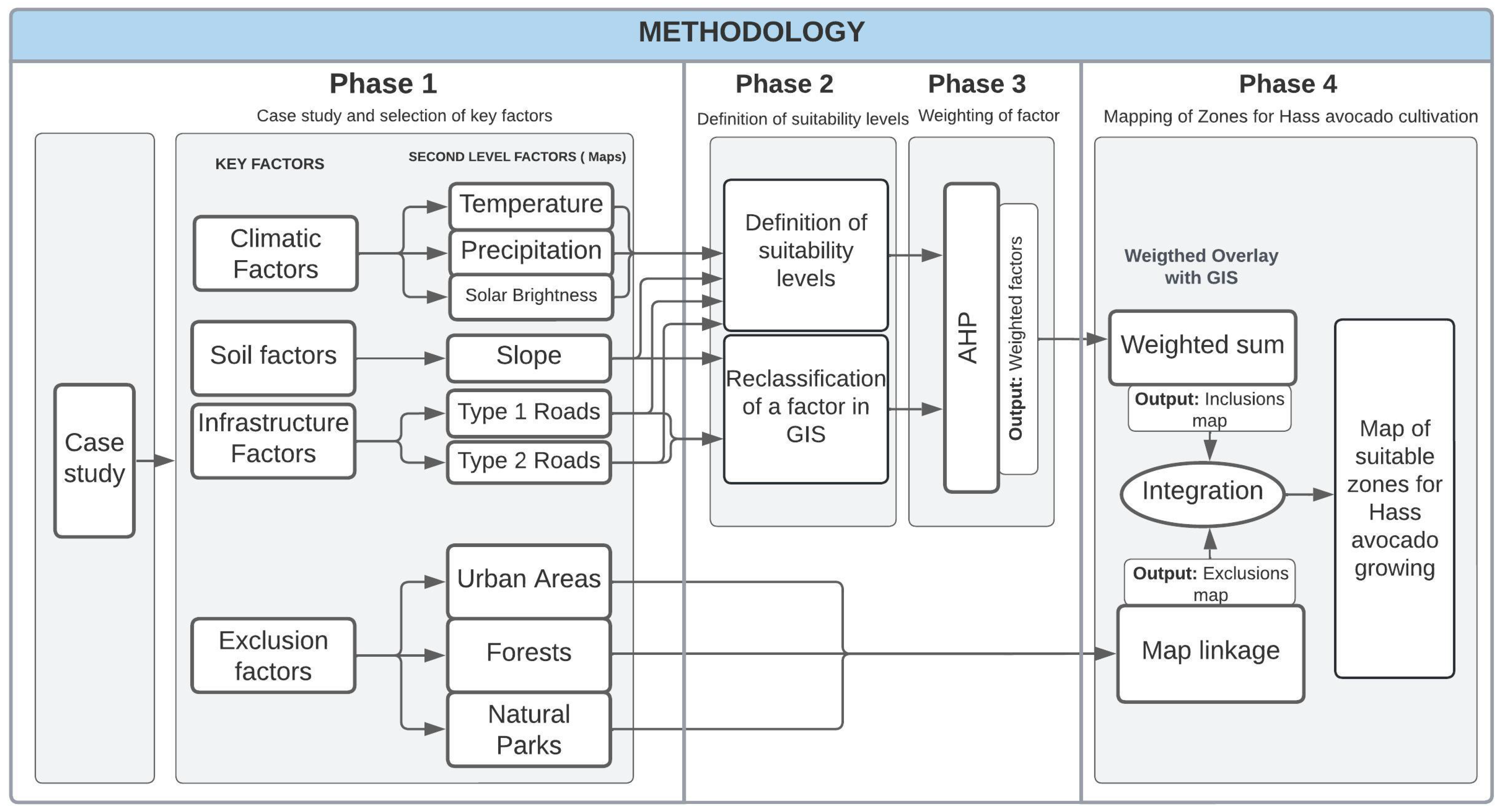
3. Materials and Methods

The suitability analysis was performed using guidelines provided by [18] and adopting the methodological framework from [31]. The research was carried out in four phases. The first phase involved identifying first- and second-level factors relevant to optimal crop growth. In the third phase, the weights of each factor were determined using the AHP. In the fourth phase, the sub-factor maps were integrated using the GIS weighted overlay technique, considering the weighting percentages resulting from the AHP. This process yielded four partial maps with the level of suitability for Hass avocado cultivation in the study region using GIS techniques.
The tools used for the geographic information system in this research were ArcGIS [32] and PAST [33] for data processing. Precipitation, temperature, and insolation data were collected from the Instituto de Hidrología, Meteorología y Estudios Ambientales (IDEAM) in Colombia, while map slope data were collected from the United States Geological Survey (USGS) digital terrain models [34]. Road data were collected from the Instituto Geográfico Agustín Codazzi (IGAC) through the Geoportal digital platform. Figure 1 indicates a diagram of the methodology used to generate the maps and determine suitable zones for Hass avocado cultivation in the Cauca department.
It is imperative to underline that the present study focuses only on assessing the suitability of the land, and does not consider any economic variables. The study site is predominantly used for extensive animal husbandry, and existing crops do not occupy a significant area. The current land use is irrelevant to the study’s objectives, as the land used for animal husbandry can be conveniently reused to grow Hass avocado or other crops [35].

3.1. Phase 1: Case Study and Selection of Key Factors

3.1.1. Case Study

The Cauca department is in southwestern Colombia and covers an area of 29,308 km2, representing 2.56% of the national territory. Its economy is primarily based on agriculture, with the most significant crops being hemp, sugarcane, coffee, potato, corn, cassava, beans, tomato, and blackberry [33]. Hass avocado production is also gaining popularity as a productive alternative in the region [36]. The economy of the Cauca department generates 1.82% of Colombia’s gross domestic product, and the region had an estimated population of 1,436,916 inhabitants as of 2020. According to the United Nations (UN), Cauca is the department in Colombia with the highest levels of illicit coca leaf cultivation, the raw material used to produce cocaine. This has made the department one of the most affected by the armed conflict between the public forces seeking to eradicate coca production and the illegal groups that seek to control this illicit activity [37]. In recent years, the Colombian government has promoted investment in the region’s agricultural sector with the support of research centers to replace illicit crops with sustainable crops that generate income for small producers and promote a sustainable economy. This highlights the importance of understanding the region’s physical, ecosystem-related, and socioeconomic characteristics to determine which crops to plant and where to plant them to make the best use of natural resources [38]. The Cauca department was selected as the study area for this research because of its potential for Hass avocado cultivation in terms of edaphoclimatic conditions and its potential planting area.

3.1.2. Selection of Key Factors (First-Level)

In this initial phase of the research, the inclusion factors were determined according to the suitable conditions for Hass avocado cultivation [31]. The first factor considered was the climate, for which the second-level factors temperature, precipitation, and solar insolation, which are determinants for fruit production, were analyzed. The second factor is the terrain, since some of its characteristics are relevant for deciding where to cultivate. For this factor, the second-level facto, slope, which refers to the angle of inclination of the land about the Earth’s surface, was analyzed. The third factor considered was the road infrastructure, considering that the crop areas are close to roads, categorized later in this paper as second-level factors, types 1 and 2.
Exclusion factors were also identified, which refer to areas that, by government regulation, should not be cultivated because they are, for example, nature reserves. Urban areas, forests, and natural parks were considered exclusion zones for this case study. Each of them will be discussed in more detail in the following section.

3.1.3. Second-Level Factors

In this subsection, as mentioned above, the first-level factors are broken down into second-level factors, which are ultimately evaluated to define the suitability of the land. These sub-factors are:
  • Average annual temperature
One of the critical factors influencing avocado production is the temperature during the flowering and fertilization periods, which limits fruit cultivation [35]. Although the avocado plant is reasonably adaptable to different temperatures, the ideal range is between 13 °C and 20 °C. Temperatures higher than 36 °C can present some limitations, particularly in fertilization and fruit set, because of the decrease in the leaves’ diffusive resistance [39]. With the Hass variety in particular, temperature affects the transition from flower to fruit. At lower temperatures, this period is extended, delaying the harvest [40]. Therefore, areas with temperatures below 13 °C and above 20 °C were excluded from the study, as they were deemed unsuitable for cultivation.
The temperature distribution for a thirty-year period from 1980 to 2010 was bought from the IDEAM using a thirty-year national historical database. The spatial data were represented using a raster format, with a spatial resolution of 1:100,000 and dimensions of 8088 columns and 8736 rows. The data were stored as a single band with 8-Bit integer pixel values and a cell size of 30 m along the X and Y axes. The information was extracted for the Cauca region using ArcGIS software, and GIS techniques were employed to demarcate areas within the optimal range for agriculture [41].
  • Average annual precipitation
Precipitation is the amount of water that falls on the Earth’s surface, i.e., the average amount of rain in an area over a period. The unit of measurement for precipitation is millimeters per year (mm/year). The Hass avocado crop requires between 1000 and 2000 mm/year for good growth and development; levels of precipitation below or above these values result in a deficit. Rain helps to wet and wash the foliage, removing the dust that can adhere to the leaves because of the action of the wind [42]. In addition, water availability is a crucial factor in the growth process, as it is the determining element. It is believed that the lower the amount of rainfall, the lower the probability that avocado trees will reach their usual average size [43].
Annual precipitation maps were acquired from the IDEAM portal using a thirty-year national historical record from 1980 to 2010. The spatial data were represented using a raster format, with a spatial resolution of 1:100,000 and dimensions of 8088 columns and 8736 rows. The data were stored as a single band with 8-Bit integer pixel values and a cell size of 30 m along the X and Y axes. The information was extracted for the Cauca region using ArcGIS software, and GIS techniques were employed to identify areas within the optimal range for agriculture [42].
  • Average daily insolation
Insolation, also known as solar brightness, refers to the number of hours in which sunrays reach the Earth’s surface directly. The unit of measurement for insolation is sunshine hours per day. Good sun exposure is beneficial for Hass avocado cultivation. It directly influences the transformation of radiant energy into chemical energy through the photosynthesis process, which involves the isolation of carbon from CO2 in the air. This contributes to the fixation of organic carbon compounds that support leaf size [44]. The Hass avocado crop should be exposed to the sun for at least 5 h daily. Levels lower than 3 h reduce photosynthetic activity by reducing the chlorophyll content of the leaves [45].
Annual daily insolation maps were retrieved from the Instituto de Hidrología, Meteorología y Estudios Ambientales website using a thirty-year national historical record from 1980 to 2010. The spatial data were represented using a raster format with a spatial resolution of 1:100,000 and dimensions of 8088 columns and 8736 rows. The data were stored as a single band with 8-bit integer pixel values and a cell size of 30 m along the X and Y axes. The Cauca region’s information was extracted using ArcGIS software, and GIS techniques were employed to demarcate areas within the optimal range for agriculture [42].
  • Slope
A land surface’s topographic gradient or slope is a critical component of its morphology. Morphology refers to the shape and structure of the land surface, and slope contributes significantly to this shape and form. Slope plays a crucial role in transporting water and nutrients through the soil profile, affecting vegetation and various aspects of soil biology. The slope can also significantly contribute to soil erosion and the potential to support built structures. The gradient or slope can be quantified in terms of the surface slope or gradient, typically represented in degrees or as a mathematical relationship between height and length. Therefore, the slope is an essential aspect of soil morphology and must be considered when analyzing soils and their use. Generally, slopes less than 25% can be worked without significant difficulty [44]. An area with a steeper slope is less stable in terms of productivity and is more prone to erosion and irrigation problems. Avocado cultivation is difficult and costly on steep slopes [46]. In addition, soil characteristics such as depth, moisture, texture, and nutrient availability can vary with slope [16].
Terrain slope maps were produced from the United States Geological Survey (USGS) digital elevation models, defining the boundary of the Cauca department using vector data and extracting the relevant information [47]. This facilitated the identification of areas with slopes of less than 25% considered suitable for avocado cultivation. A raster format with a spatial resolution of 1:100,000 and dimensions of 7222 columns and 7181 rows were used for the spatial data. The data were stored in a single band with 16-bit integer pixel values and a cell size of 31.2 m along the X and Y axes.
  • Type 1 and 2 Roads
According to the Colombian National Traffic Code, roads are public or private spaces open to the public and intended for transit vehicles, people, and animals [48]. This regulation characterizes type 1 roads as having two or more lanes used throughout the year. Type 2 roads are not paved, have two or more lanes, and are used year-round.
The proximity of roads to agricultural areas is a crucial factor in the fruit production industry’s competitiveness. Adequate road accessibility in good condition, whether paved or unpaved, reduces production costs, maintenance costs, transit time to service centers, and other associated costs, thus enabling the efficient movement of the product to commercial channels [18]. The road data used in this study were acquired from [49]. The spatial data were represented using a raster format, with a spatial resolution of 1:100,000 and dimensions of 1694 columns and 1903 rows. The data were stored as a single band with 32-bit integer pixel values and a cell size of 137 m along the X and Y axes.
  • Protected areas, forest edges, and prohibited areas
The study region has 1,635,639 hectares of conservation forests and 738,339 hectares of natural parks and nature reserves. The government restricts the use of these territories for agricultural production. Therefore, these areas are excluded from the study [50]. This exclusion is necessary to comply with government regulations and to ensure the preservation of natural habitats and biodiversity in the region.

3.2. Phase 2: Definition of Suitability Levels

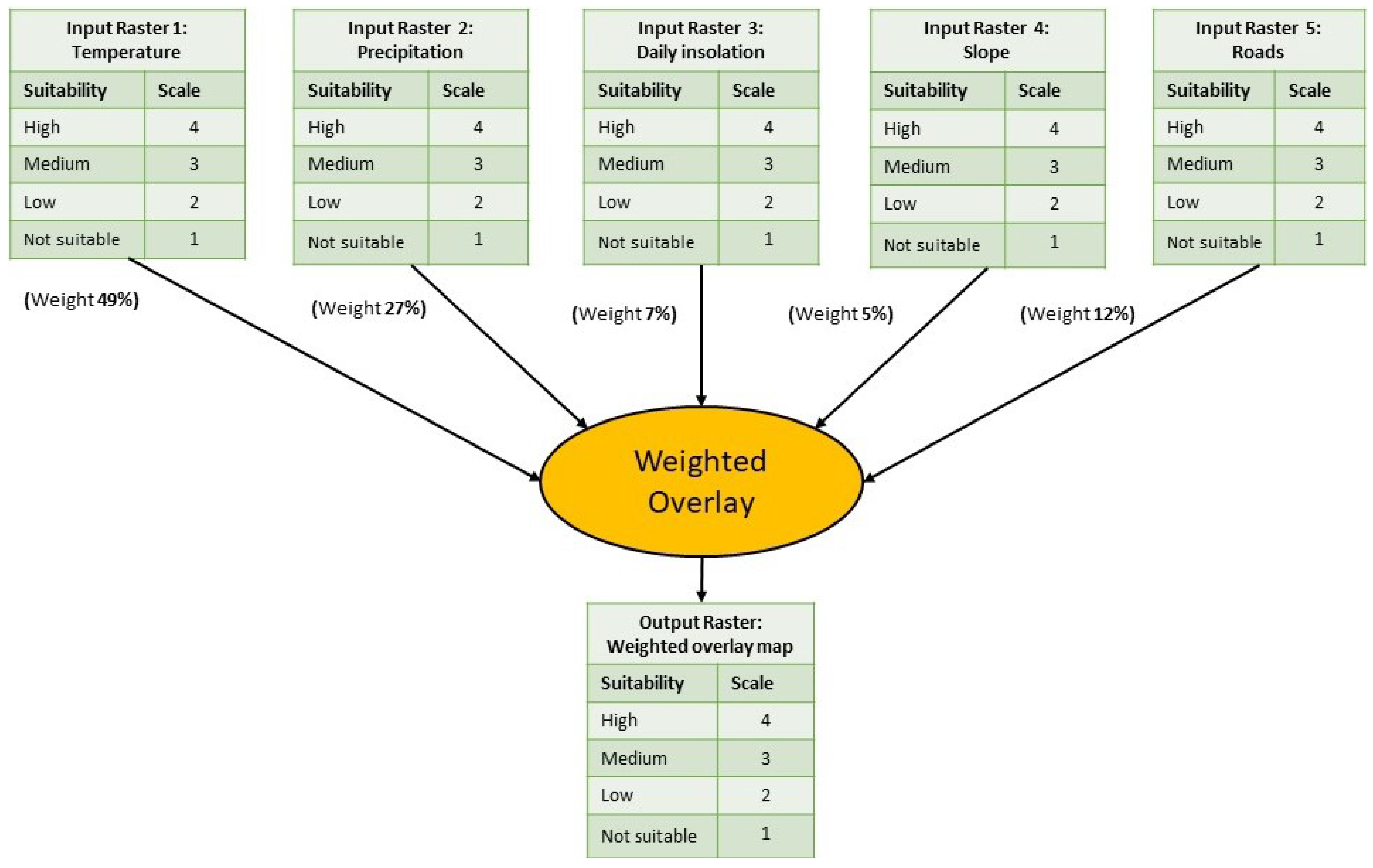
3.2.1. Suitability Levels by Factor

To determine land suitability levels for the selected zones as an output variable of the evaluation, corresponding ranges were defined based on the study of suitability zoning for the commercial cultivation of Hass avocados in Colombia conducted by the national government. This study defined four levels of suitability, each with a corresponding qualitative evaluation and assigned quantitative value, as shown in Table 1.
The “Not suitable” category includes areas that do not meet the evaluation criteria, such as those with values below the minimum or above the maximum, and those that cannot be used because of legal exclusion. The ranges that define each level of suitability were also established for the input linguistic variables in the fuzzy environment of the software based on the criteria defined in the study mentioned above. Table 2 indicates the ranges established for each factor according to the criteria defined in [51].

3.2.2. Reclassification of Factors in GIS

The initial parameterization of the GIS model did not employ a standard scale of values to define the suitability levels of the specified factors. Therefore, it was necessary to reassign new values to the factors of slopes and roads using the Reclassify tool provided by the Spatial Analyst extension of ArcMap.
The suitability of slopes were initially divided into four levels based on the percentage of slope inclination. Slopes with an inclination of less than 25% were assigned a scale value of 4, showing the highest level of suitability. Slopes with an inclination between 25% and 50% were assigned a value of 3, indicating moderate suitability. Slopes with an inclination between 50% and 75% were assigned a value of 2, indicating low suitability. Slopes with an inclination of more than 75% were assigned a value of 1, indicating they are unsuitable for avocado cultivation.
The proximity to road types 1 and 2 was reclassified using the same approach. The values assigned to this factor were determined by the distance of the land from the roads, with a value of 4 assigned to distances of 1000 m or less, a value of 3 assigned to distances between 1000 and 2000 m, a value of 2 assigned to distances between 2000 and 4000 m, and a value of 1 assigned to distances greater than 4000 m.
The factors of temperature, precipitation, and solar brightness already had established ranges, and were assigned numerical scale values by default. For example, areas with a value of 1 were problematic for any of these factors.
Table 3 shows the type of classification and the scale value defined for each of the factors with their respective rating and scale value.
The classification and the scale value assigned to each range with an influence weight assigned to each factor.

3.3. Phase 3: Weighting of Factors Using AHP

AHP is a multi-criteria decision-making technique that allows for selecting the best alternative based on multiple factors or criteria in the decision-making process [18]. This tool has the flexibility to be applied to various domains for solving decision-making problems, and is also used to rank decision factors. In this study, AHP was used to weight the suitability factors by conducting paired comparisons to evaluate the five factors’ importance in crop productivity. The Saaty scale [52,53] was used for the pairwise comparison of each factor, ranging from 1 to 9. See Table 4.
The benchmarking and selection process was initiated with a comprehensive bibliographic review aimed at identifying the critical factors impacting Hass avocado production. The key factors, including temperature, precipitation, slope, and proximity to major highways, were identified as crucial to the efficient production of the fruit. To evaluate these factors, five domain experts were recruited to assign a value to each factor based on its significance. This was accomplished through semi-structured interviews in which each factor was rated on a scale of 1 to 9, with a score of 1 showing that both factors have equal importance and 9 indicating that one factor is significantly more important than the other. The paired comparison matrix obtained from the expert ratings is presented in Table 5. The results of the experts indicate that temperature is the most impactful factor on Hass avocado production.
The AHP methodology provides a consistency analysis to evaluate the consistency of the answers in the pairwise comparison matrix. In this study, the consistency ratio was 0.07, showing that the matrix was consistent.
The pairwise comparison resulted in an eigenvector with the weights of each criterion, as shown in Table 6.
The weighting percentages complete the input data needed to generate a map classified into high, medium, low, and unsuitable zones, based on the complementarity resulting from ArcGIS.

3.4. Phase 4: Mapping of Zones for Hass Avocado Cultivation

Weighted overlay is a commonly used approach in overlay analysis, allowing for multi-criteria evaluations, such as facility selection and suitability modeling. Based on the five selected factors (temperature, precipitation, insolation, slope, roads) and their respective suitability scales, this section evaluated the study areas to develop fruit crop suitability maps. This approach is used when the input factors in the evaluation are of different importance.
As determined from the hierarchical ranking performed using AHP, the temperature criterion had the highest weight at 49%, followed by precipitation at 27%, proximity to roads at 12%, and insolation at 7%, and the lowest weight was assigned to slope at 5%. The indicated weighted overlay model is shown in Figure 2.
Once the data for each input factor are constructed for an area to be evaluated, the values of the standard scale and the weighting of each factor are assigned. The input pixel matrix for each factor is obtained, and each input raster is loaded into the software, which multiplies the cell values of each input raster by its importance weighting and sums the resulting cell values to produce an output map or raster in pixel matrix format.

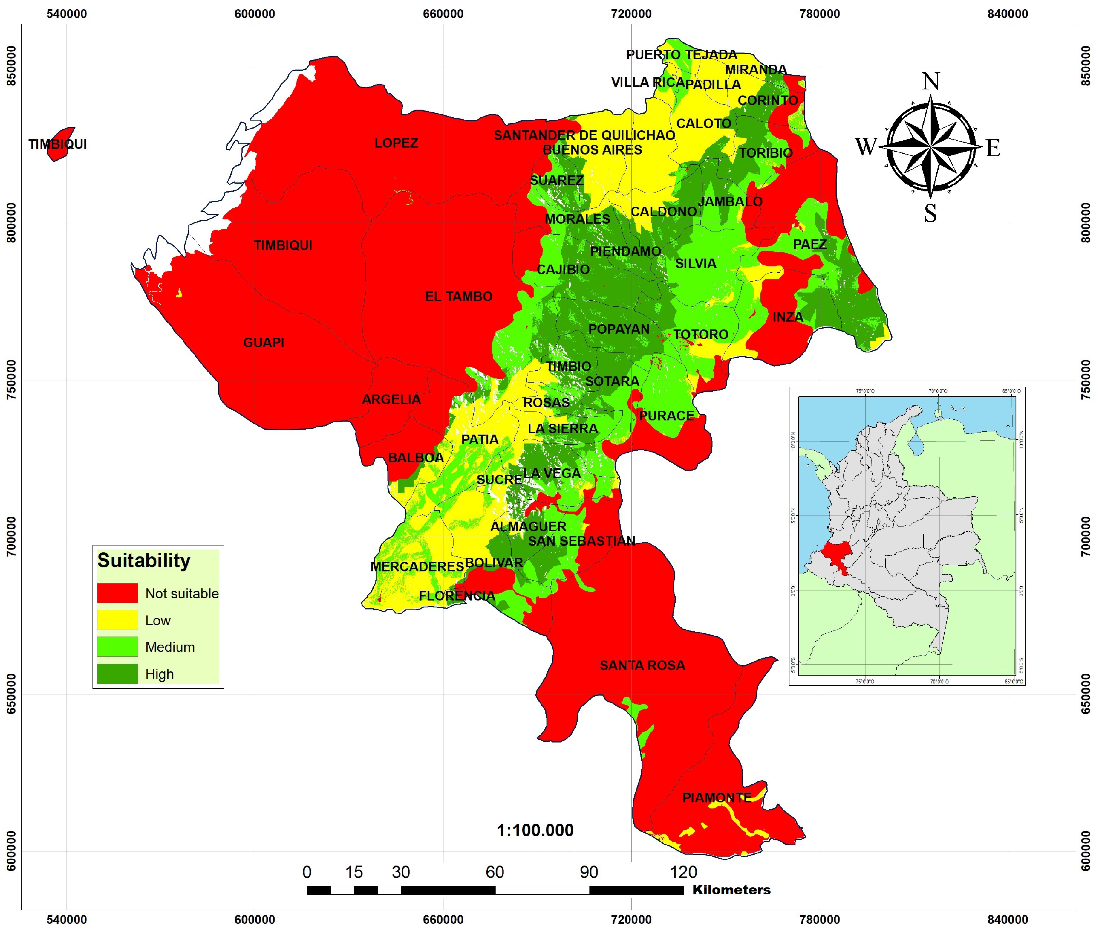
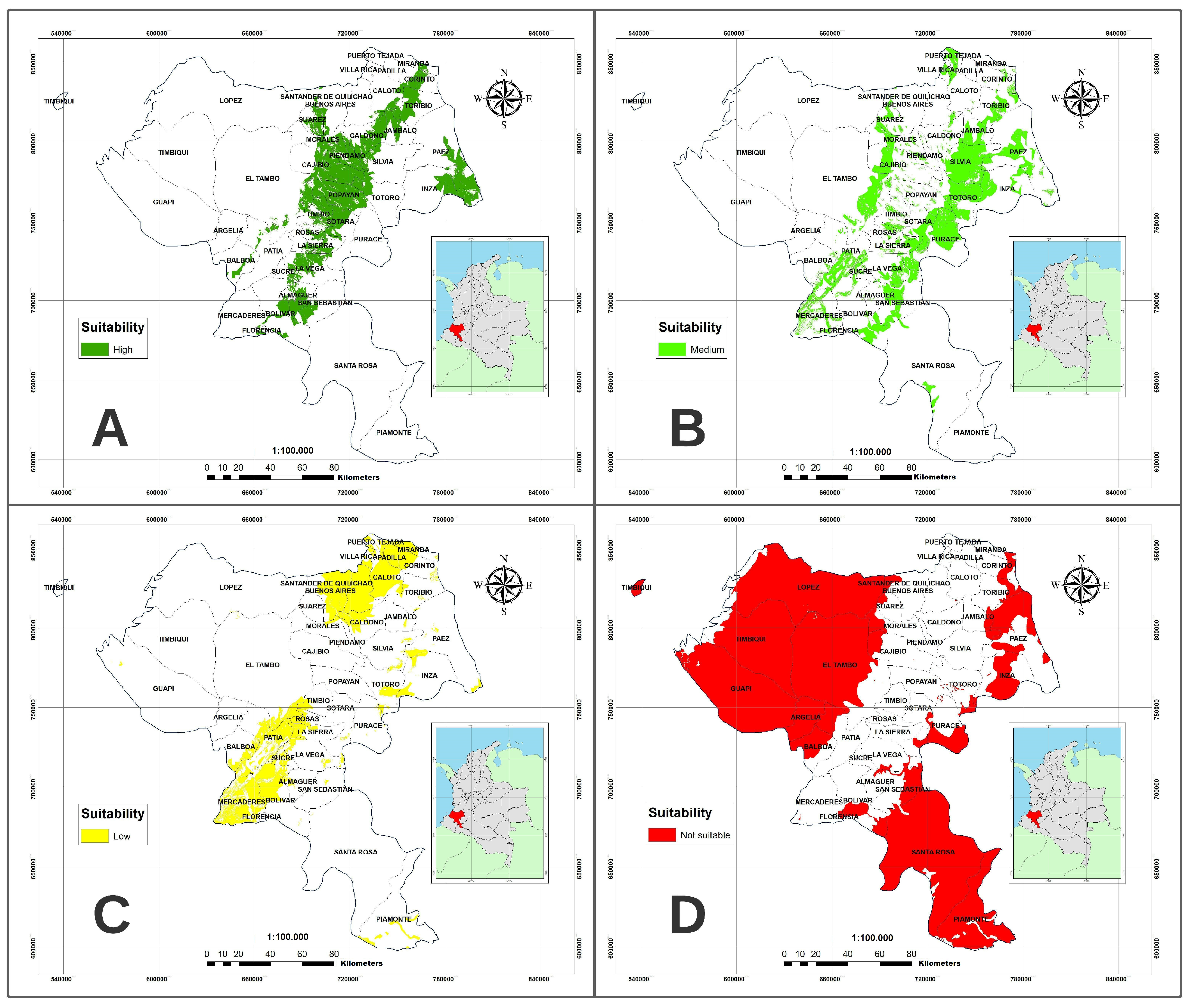
4. Results and Discussion

This study aimed to identify the optimal zones for Hass avocado cultivation. It classified the territorial zones of the region into four categories: high, medium, low, and unsuitable aptitude. Seven input parameters were used: mean annual temperature, mean annual precipitation, average daily insolation, and a digital terrain model. Forest edges and type 1 and 2 roads were used to define a mask layer representing the physical limitations of avocado cultivation. The Hass avocado zoning study conducted by the Unidad de Planificación Rural Agropecuaria (UPRA) at the national level was used as a reference to determine the categorization ranges. Each factor was weighted using the AHP multi-criteria analysis methodology. Consultation with experts in Hass avocado production and marketing was necessary, and their expertise in the area was invaluable for this study. The consistency analysis of the experts’ paired matrix indicated that their comparisons were coherent. A consolidated map was generated to identify the municipalities with the potential for Hass avocado cultivation (Figure 3).
The main result of the research was a map of the Cauca department in which the dark and light green zones are of high and medium aptitude, respectively, for avocado cultivation. The yellow zones indicate low aptitude, while the red zones are unsuitable for avocado cultivation because of unsuitable production and marketing conditions or government protection.
Specifically, 9.2% of the study area, corresponding to 274,687 hectares, was established as a highly suitable zone (dark green zones) for Hass avocado cultivation. In comparison, 14.2% (422,681 ha) and 10.6% (316,232 ha) were classified as zones with medium (light green zones) and low suitability (yellow zones), respectively. Unsuitable zones (red zones) correspond to 65.9% of the study area.
The municipalities located on and around the Popayán plateau are the most suitable for Hass avocado cultivation based on the selected criteria and their relative importance, with the most representative administrative zones being the municipalities of Popayán, Timbío, Sotará, Piendamó, Cajibío, and Morales. These municipalities align with previous research on the characterization of Hass avocado producers, where surveys and data collection from rural support units were used to determine new performance indicators for fruit production [54,55]. Additionally, studies have been conducted on determining pollinating agents in the municipalities of Morales and Cajibío for the Hass variety [56]. This evidence supports the validity of the resulting map with local empirical evidence.
The municipalities located near the Cauca boot, such as La Vega, Almaguer, and the lower part of San Sebastián, are potential territories for Hass avocado cultivation because of their high suitability (Figure 4A). This is mainly because their average annual temperature is between 12 and 20 °C and annual rainfall is between 1000 and 1500 mm, which optimally combines the factors for fruit production according to expert recommendations. These administrative zones are also producers of other crops such as coffee, sugar cane, banana, and fruit trees, and cattle ranching has a strong presence, making them suitable candidates for Hass avocado cultivation as a natural alternative to their traditional production. Local government entities could implement promotion plans to increase Hass avocado production as part of development policies, directly diversifying the municipal economy. The municipalities of Morales, Cajibío, Piendamó, Caldono, Tambo, Timbío, Popayán, Sotará, Caloto, Corinto, and Toribio have received incentives for the research community to propose science and technology initiatives, allowing producers to be trained in correct Hass avocado production, and other research aimed at increasing the technological value of the fruit. The fact that most of the municipalities where the resulting map shows high aptitude are already planting Hass avocado on a small scale further supports the reliability of the map, and suggests the potential for continued research proposals to improve the production of this export-type product in these municipalities.
Figure 4B indicates those areas of the Cauca territory where the aptitude for Hass avocado cultivation is considered medium, where the crop could be grown but does not have the ideal conditions according to the factors included in this study. Municipalities such as Totoró, Suárez, La Sierra, Puracé, and Silvia could consider Hass avocado production to diversify their economy, considering that factors such as temperature and precipitation are not ideal. However, as suggested by [57], fruits with export quality and domestic consumption could be produced with technological developments and the application of concepts such as climate-smart agriculture.
The suitability for Hass avocado production is low in certain municipalities (Figure 4C) because of factors such as inadequate temperature and precipitation and poor access to roads for the production chain. In this sense, it is observed that the municipalities near the Cauca boot (except for La Vega, Almaguer, and the lower area of San Sebastián) do not present adequate conditions for the production of the Hass variety; this could be related to the fact that they are departments with average annual temperatures above 24 °C, which decreases the diffusive resistance of the leaves, indirectly affecting the production of photosynthesis and, therefore, the fruit set. Additionally, annual rainfall in these areas is between 3000 and 4000 mm, classified as low on the suitability scale. This suggests that temperature, rather than annual rainfall or other factors, is the primary determinant of the resulting map. This aligns with the expert consensus that temperature is a key factor for the growth and production of the Hass avocado variety.
The map in Figure 4D indicates that most of the Cauca territory is unsuitable for Hass avocado production (shown in red). This is because of a combination of factors, including unfavorable temperature and precipitation conditions, the absence or poor state of roads for transporting the product, and the prevalence of legal exclusion zones. The results suggest specific soil and climatic conditions limit the overall Hass avocado production in the Cauca department. However, the low level of technological development and slow general development of the area also contribute to this limitation.

Factors Affecting the Validity of This Hass Avocado Crop Suitability Study

The validity of this Hass avocado crop suitability study will depend on several factors, including the location, timing, and changing climate. The rate at which climatic conditions change and their impact on Hass avocado crops may affect this study’s results. Temperature and rainfall are significant limiting factors for Hass avocados, so sudden and significant changes in these conditions can affect this study’s validity. Previous research has examined the potential effects of climate change on the growing conditions for Hass avocados in the coming years. For instance, Grüter et al. [58] examined the impact of climate change on avocado, cashew, and arabica coffee crops. Studies have found that avocados may not experience significant changes because of climate change until 2050 in regions suitable for their cultivation. In countries such as Mexico, the United States, Brazil, and Colombia, an increase in minimum temperatures during the coldest season of the year and an increase in minimum rainfall are anticipated, which may lead to improved conditions for Hass avocado cultivation in these countries. This could expand the areas suitable for avocado cultivation, particularly in Colombia. Ramirez Gil [36] conducted a study using ecological niche modeling techniques to evaluate the effects of climate change on Hass avocado production in Latin America. The analysis used 22 general circulation models, two emissions models, and six parameterization models. The findings suggest that the potential distribution of Hass avocado crops may decrease in high- and low-latitude regions, while in temperate climate zones where the climate is not expected to be significantly affected, crop potential may remain unchanged, as observed in the Cauca department. Previous research has indicated the temporal validity of the current study, with results remaining consistent over nearly 30 years. This suggests that the conditions underlying this study are relatively stable, and the study’s validity is likely to be sustained in the short and median terms. As a future direction, it may be beneficial to incorporate climate change models, based on predicted conditions, into the model employed in this study.

5. Conclusions

This study aimed to establish the most favorable locations for Hass avocado cultivation within the Cauca department in Colombia. Suitability levels were established by evaluating several factors, including mean annual temperature, mean annual precipitation, mean daily insolation, terrain slope, road infrastructure, and consideration of legal exclusion zones. The hierarchical analytical process was used to determine the relative importance of each factor, and the ArcGIS tool was used to generate a map that categorizes regions based on their suitability for fruit production. The study’s results revealed a greater extent of regions suitable for Hass avocado cultivation compared to a previous study conducted by UPRA at the national level. It achieved this by incorporating the type 1 and 2 roads and the 4G roads considered in the UPRA study, thus expanding the potential production areas within the optimal parameters for Hass avocado cultivation.
It is noteworthy that in various municipalities where the resulting map shows high suitability for Hass avocado cultivation, the fruit is already being grown on a small scale. Of the 23.4% (almost 700,000 hectares) of medium and high suitability areas, less than 2% (about 1000 hectares) is currently used for Hass avocado production, highlighting the reliability of the map and supporting the need for further research to support agricultural development in the area.
Future works could include local estimates based on grower knowledge and additional soil analysis to collect localized data that can apply to other study areas. In addition, a broader panel of experts with field experience could also be assembled to obtain more reliable results for decision-making in agricultural commodities. Finally, the methodological framework used in this study has the potential to be generalized to other crops in different contexts, making it a practical approach for developing agricultural management policies and supporting economic diversification decisions based on geographic information systems.

Author Contributions

Conceptualization, Yesid Ediver Anacona Mopan and Isabel Ramirez Mejia; methodology, Yesid Ediver Anacona Mopan, Andrés Felipe Solis Pino, Oscar Rubiano-Ovalle, Isabel Ramirez Mejia and Helmer Paz; software, Yesid Ediver Anacona Mopan and Andrés Felipe Solis Pino; validation, Andrés Felipe Solis Pino, Oscar Rubiano-Ovalle and Helmer Paz; formal analysis, Andrés Felipe Solis Pino and Yesid Ediver Anacona Mopan; writing—review and editing, Yesid Ediver Anacona Mopan, Andrés Felipe Solis Pino, Isabel Ramirez Mejia, Oscar Rubiano-Ovalle and Helmer Paz All authors have read and agreed to the published version of the manuscript.

Funding

This research received no external funding, and the APC was funded by Corporación Universitaria Comfacauca and Universidad del Valle.

Data Availability Statement

The materials used in this research can be accessed through the following link (https://cutt.ly/aFNfQ62).

Conflicts of Interest

The authors declare no conflict of interest.

Abbreviations

The following abbreviations are used in this manuscript:
MCDAMulti-criteria Decision Analysis
ton/hectareTons per hectare
AHPAnalytic Hierarchy Process
GISGeographic Information Systems
TOPSISTechnique for Order of Preference by Similarity to Ideal Solution
IDEAMInstitute of Hydrology, Meteorology and Environmental Studies
USGSUnited States Geological Survey
IGACInstituto Geográfico Agustín Codazzi
USGSUnited States Geological Survey
UNOUnited Nations Organization
UPRAUnidad de Planificación Rural Agropecuaria

References

  1. Ginting, M.H.S.; Irvan; Misran, E.; Maulina, S. Potential of Durian, Avocado and Jackfruit Seed as Raw Material of Bioethanol: A Review. IOP Conf. Ser. Mater. Sci. Eng. 2020, 801, 012045. [Google Scholar] [CrossRef]
  2. Belda, R. Análisis de Competitividad y Consistencia de Las Exportaciones Mexicanas de Aguacate; Universitat Politècnica de València: Valencia, Spain, 2017. [Google Scholar]
  3. Charre-Medellín, J.F.; Mas, J.-F.; Chang-Martínez, L.A. Potential Expansion of Hass Avocado Cultivation under Climate Change Scenarios Threatens Mexican Mountain Ecosystems. Crop Pasture Sci. 2021, 72, 291–301. [Google Scholar] [CrossRef]
  4. Cervantes-Paz, B.; Yahia, E.M. Avocado Oil: Production and Market Demand, Bioactive Components, Implications in Health, and Tendencies and Potential Uses. Compr. Rev. Food Sci. Food Saf. 2021, 20, 4120–4158. [Google Scholar] [CrossRef] [PubMed]
  5. Xiong, B.; Song, Y. Big Data and Dietary Trend: The Case of Avocado Imports in China. J. Int. Food Agribus. Mark. 2018, 30, 343–354. [Google Scholar] [CrossRef]
  6. Schwartz, M.; Maldonado, Y.; Luchsinger, L.; Lizana, L.A.; Kern, W. Competitive Peruvian and Chilean Avocado Export Profile. Acta Hortic. 2018, 1194, 1079–1083. [Google Scholar] [CrossRef]
  7. Alzate Restrepo, S.; Chica Garcés, J.A. Estructuración Financiera de Un Fondo de Capital Privado Como Estrategia de Inversión Para La Producción de Aguacate Hass En Colombia. Ph.D. Thesis, Universidad EAFIT, Medellín, Colombia, 2022. [Google Scholar]
  8. García, J.S.A.; Hurtado-Salazar, A.; Ceballos-Aguirre, N. Current Overview of Hass Avocado in Colombia. Challenges and Opportunities: A Review. Ciênc. Rural 2021, 51, 1–9. [Google Scholar] [CrossRef]
  9. Solarte-Toro, J.C.; Ortiz-Sanchez, M.; Restrepo-Serna, D.L.; Piñeres, P.P.; Cordero, A.P.; Alzate, C.A.C. Influence of Products Portfolio and Process Contextualization on the Economic Performance of Small- and Large-Scale Avocado Biorefineries. Bioresour. Technol. 2021, 342, 126060. [Google Scholar] [CrossRef]
  10. Vergara, J.R.G. La Economía Del Departamento Del Cauca: Concentración de Tierras y Pobreza; Banco de la República, Centro de Estudios Económicos Regionales: Cartagena, Colombia, 2007. [Google Scholar]
  11. IGAC (Instituto Geografico Agustin Codazzi). Geodatabase. 2019. Available online: https://geoportal.igac.gov.co/contenido/datos-abiertos-cartografia-y-geografia (accessed on 8 February 2022).
  12. Selim, S.; Koc-San, D.; Selim, C.; San, B.T. Site Selection for Avocado Cultivation Using GIS and Multi-Criteria Decision Analyses: Case Study of Antalya, Turkey. Comput. Electron. Agric. 2018, 154, 450–459. [Google Scholar] [CrossRef]
  13. Ramírez-Gil, J.G.; Martínez, G.O.G.; Morales Osorio, J.G. Design of Electronic Devices for Monitoring Climatic Variables and Development of an Early Warning System for the Avocado Wilt Complex Disease. Comput. Electron. Agric. 2018, 153, 134–143. [Google Scholar] [CrossRef]
  14. Orhan, O.; Yakar, M.; Ekercin, S. An Application on Sinkhole Susceptibility Mapping by Integrating Remote Sensing and Geographic Information Systems. Arab. J. Geosci. 2020, 13, 886. [Google Scholar] [CrossRef]
  15. Seyedmohammadi, J.; Sarmadian, F.; Jafarzadeh, A.A.; McDowell, R.W. Development of a Model Using Matter Element, AHP and GIS Techniques to Assess the Suitability of Land for Agriculture. Geoderma 2019, 352, 80–95. [Google Scholar] [CrossRef]
  16. Parry, J.A.; Ganaie, S.A.; Sultan Bhat, M. GIS Based Land Suitability Analysis Using AHP Model for Urban Services Planning in Srinagar and Jammu Urban Centers of J&K, India. J. Urban Manag. 2018, 7, 46–56. [Google Scholar] [CrossRef]
  17. Miller, H.J.; Dodge, S.; Miller, J.; Bohrer, G. Towards an Integrated Science of Movement: Converging Research on Animal Movement Ecology and Human Mobility Science. Int. J. Geogr. Inf. Sci. 2019, 33, 855–876. [Google Scholar] [CrossRef] [PubMed] [Green Version]
  18. Orhan, O. Land Suitability Determination for Citrus Cultivation Using a GIS-Based Multi-Criteria Analysis in Mersin, Turkey. Comput. Electron. Agric. 2021, 190, 106433. [Google Scholar] [CrossRef]
  19. Poggio, L.; Simonetti, E.; Gimona, A. Enhancing the WorldClim Data Set for National and Regional Applications. Sci. Total Environ. 2018, 625, 1628–1643. [Google Scholar] [CrossRef] [PubMed]
  20. Suhairi, T.A.S.T.M.; Jahanshiri, E.; Nizar, N.M.M. Multicriteria Land Suitability Assessment for Growing Underutilised Crop, Bambara Groundnut in Peninsular Malaysia. IOP Conf. Ser. Earth Environ. Sci. 2018, 169, 12044. [Google Scholar] [CrossRef]
  21. Kazemi, H.; Akinci, H. A Land Use Suitability Model for Rainfed Farming by Multi-Criteria Decision-Making Analysis (MCDA) and Geographic Information System (GIS). Ecol. Eng. 2018, 116, 1–6. [Google Scholar] [CrossRef]
  22. Mu, W.; Gong, S.; Stankovski, S.; Zhang, X.; Kanianska, R.; Feng, L. WebGIS-based suitability evaluation system for Chinese table grape production. Comput. Electron. Agric. 2019, 165, 104945. [Google Scholar] [CrossRef]
  23. Crispim, D.L.; Progênio, M.F.; Fernandes, L.L. Proposal for a Tool for Assessing Access to Water in Rural Communities: A Case Study in the Brazilian Semi-Arid. Environ. Manag. 2022, 69, 529–542. [Google Scholar] [CrossRef]
  24. Alemdar, K.D.; Kaya, Ö.; Çodur, M.Y. A GIS and Microsimulation-Based MCDA Approach for Evaluation of Pedestrian Crossings. Accid. Anal. Prev. 2020, 148, 105771. [Google Scholar] [CrossRef]
  25. Ghorbanzadeh, O.; Pourmoradian, S.; Blaschke, T.; Feizizadeh, B. Mapping potential nature-based tourism areas by applying GIS-decision making systems in East Azerbaijan Province, Iran. J. Ecotourism 2019, 18, 261–283. [Google Scholar] [CrossRef]
  26. Mokarram, M.; Mokarram, M.J.; Gitizadeh, M.; Niknam, T.; Aghaei, J. A novel optimal placing of solar farms utilizing multi-criteria decision-making (MCDA) and feature selection. J. Clean. Prod. 2020, 261, 121098. [Google Scholar] [CrossRef]
  27. Hussaini, M.S.; Farahmand, A.; Shrestha, S.; Neupane, S.; Abrunhosa, M. Site selection for managed aquifer recharge in the city of Kabul, Afghanistan, using a multi-criteria decision analysis and geographic information system. Hydrogeol. J. 2022, 30, 59–78. [Google Scholar] [CrossRef]
  28. Nasution, A.J.; Mulia, A.P. Pemetaan Kawasan Kumuh Menggunakan Metode AHP dan GIS di Kota Tanjungbalai. J. Syntax Admiration 2021, 2, 1580–1594. [Google Scholar]
  29. Ruiz, H.S.; Sunarso, A.; Ibrahim-Bathis, K.; Murti, S.A.; Budiarto, I. GIS-AHP Multi Criteria Decision Analysis for the optimal location of solar energy plants at Indonesia. Energy Rep. 2020, 6, 3249–3263. [Google Scholar] [CrossRef]
  30. Ghavami, S.M. Multi-criteria spatial decision support system for identifying strategic roads in disaster situations. Int. J. Crit. Infrastruct. Prot. 2019, 24, 23–36. [Google Scholar] [CrossRef]
  31. Harper, M.; Anderson, B.; James, P.; Bahaj, A. Assessing Socially Acceptable Locations for Onshore Wind Energy Using a GIS-MCDA Approach. Int. J. Low-Carbon Technol. 2019, 14, 160–169. [Google Scholar] [CrossRef]
  32. Chen, Y.; Zheng, B.; Hu, Y. Mapping Local Climate Zones Using ArcGIS-Based Method and Exploring Land Surface Temperature Characteristics in Chenzhou, China. Sustainability 2020, 12, 2974. [Google Scholar] [CrossRef] [Green Version]
  33. Solis, A.F.; Revelo luna, D.A.; Campo Ceballos, D.A.; Gaviria López, C.A. Correlación Del Contenido de Clorofila Foliar de La Especie Coffea Arabica Con Índices Espectrales En Imágenes. Biotecnol. En El Sect. Agropecu. Agroind. 2021, 19, 51–68. [Google Scholar] [CrossRef]
  34. Daudon, C.; Lucas, A.; Rodriguez, S.; Jacquemoud, S.; Escalante López, A.; Grieger, B.; Howington-Kraus, E.; Karkoschka, E.; Kirk, R.L.; Perron, J.T.; et al. A New Digital Terrain Model of the Huygens Landing Site on Saturn’s Largest Moon, Titan. Earth Space Sci. 2020, 7, e2020EA001127. [Google Scholar] [CrossRef]
  35. Ramesh, T.; Bolan, N.S.; Kirkham, M.B.; Wijesekara, H.; Kanchikerimath, M.; Rao, C.S.; Sandeep, S.; Rinklebe, J.; Ok, Y.S.; Choudhury, B.U.; et al. Soil organic carbon dynamics: Impact of land use changes and management practices: A review. Adv. Agron. 2019, 156, 1–107. [Google Scholar] [CrossRef]
  36. Ramírez-Gil, J.G.; Morales, J.G.; Peterson, A.T. Potential Geography and Productivity of “Hass” Avocado Crops in Colombia Estimated by Ecological Niche Modeling. Sci. Hortic. 2018, 237, 287–295. [Google Scholar] [CrossRef]
  37. Baptiste, B.; Pinedo-Vasquez, M.; Gutierrez-Velez, V.H.; Andrade, G.I.; Vieira, P.; Estupiñán-Suárez, L.M.; Londoño, M.C.; Laurance, W.; Lee, T.M. Greening Peace in Colombia. Nat. Ecol. Evol. 2017, 1, 0102. [Google Scholar] [CrossRef] [PubMed]
  38. Serrano, A.; Brooks, A. Who Is Left behind in Global Food Systems? Local Farmers Failed by Colombia’s Avocado Boom. Environ. Plan. E Nat. Space 2019, 2, 348–367. [Google Scholar] [CrossRef] [Green Version]
  39. Martinez-Corona, R.; Banderas-martinez, F.J.; Perez-castillo, J.N.; Cortes-penagos, C.; González-hernández, J.C. Avocado Oil as an Inducer of the Extracellular Lipase Activity of Kluyveromyces Marxianus L-2029. Food Sci. Technol. 2019, 40, 121–129. [Google Scholar] [CrossRef] [Green Version]
  40. Arpaia, M.L.; Collin, S.; Sievert, J.; Obenland, D. ‘Hass’ Avocado Quality as Influenced by Temperature and Ethylene Prior to and during Final Ripening. Postharvest Biol. Technol. 2018, 140, 76–84. [Google Scholar] [CrossRef]
  41. Catálogo de Mapas—IDEAM. Available online: http://www.ideam.gov.co/web/siac/catalogo-de-mapas (accessed on 9 April 2022).
  42. Domínguez, M.P.; Araus, K.; Bonert, P.; Sánchez, F.; San Miguel, G.; Toledo, M. The Avocado and Its Waste: An Approach of Fuel Potential/Application. In Environment, Energy and Climate Change II; Lefebvre, G., Jiménez, E., Cabañas, B., Eds.; The Handbook of Environmental Chemistry; Springer International Publishing: Cham, Switzerland, 2014; Volume 34, pp. 199–223. [Google Scholar] [CrossRef]
  43. Bustamante González, C.; Pérez Díaz, A.; Rivera Espinosa, R.; Martín Alonso, G.M.; Viñals Nuñez, R. Influencia de Las Precipitaciones En El Rendimiento de Coffea Canephora Pierre Ex Froehner Cultivado En Suelos Pardos de La Región Oriental de Cuba. Cultiv. Trop. 2015, 36, 21–27. [Google Scholar]
  44. Tinyane, P.P.; Soundy, P.; Sivakumar, D. Growing ‘Hass’ Avocado Fruit under Different Coloured Shade Netting Improves the Marketable Yield and Affects Fruit Ripening. Sci. Hortic. 2018, 230, 43–49. [Google Scholar] [CrossRef]
  45. Salazar-García, S.; Medina-Carrillo, R.E.; Álvarez-Bravo, A. Influencia del riego y radiación solar sobre el contenido de fitoquímicos en la piel de frutos de aguacate ‘Hass’. Rev. Mex. Cienc. Agríc. 2016, 7, 2565–2575. [Google Scholar]
  46. de Jesús Guerrero, E.; Rubio, W.; Torres, W.; Saavedra, S.H.; Muñoz, L.M.M.; Reyes, C.; Villegas, B.; Morales, C.S.; de Jesús Jarma, A.; Careño, J.A.F.; et al. Manual Para El Cultivo de Frutales En El Trópico; Produmedios: Bogota, Colombia, 2012. [Google Scholar]
  47. Kirubakaran, M.; Colins Johnny, J.; Samson, S. MODFLOW Based Groundwater Budgeting Using GIS: A Case Study from Tirunelveli Taluk, Tirunelveli District, Tamil Nadu, India. J. Indian Soc. Remote Sens. 2018, 46, 783–792. [Google Scholar] [CrossRef]
  48. Mosquera Laverde, W.E.; Vásquez Bernal, O.A. Herramientas de Gestión Ambiental Para Las Carreteras de Cuarta Generación (4g) En Colombia. Publicaciones E Investig. 2015, 9, 87–98. [Google Scholar] [CrossRef]
  49. Benadero, M.P.; Jenni, L.; Morales, A.A.; Guarín, A.; Barón, L.V. El Geoportal Para La Administración de Tierras En Colombia. In Revista Cartográfica; Comisión de Cartografía del Instituto Panamericano de Geografía e Historia (IPGH): Mexico City, Mexico, 2017; pp. 151–167. [Google Scholar]
  50. IDEAM. Catálogo de Mapas—IDEAM. Available online: http://www.siac.gov.co/catalogo-de-mapas (accessed on 21 December 2021).
  51. UPRA. Cultivo Comercial de Aguacata Hass Identificación de Zonas Aptas En Colombia a Escala 1:100.000; Rural Agricultural Planning Unit—UPRA: Bogota, Colombia, 2013; Volume 53. [Google Scholar]
  52. Franek, J.; Kresta, A. Judgment Scales and Consistency Measure in AHP. Procedia Econ. Financ. 2014, 12, 164–173. [Google Scholar] [CrossRef] [Green Version]
  53. Orhan, O.; Bilgilioglu, S.S.; Kaya, Z.; Ozcan, A.K.; Bilgilioglu, H. Assessing and Mapping Landslide Susceptibility Using Different Machine Learning Methods. Geocarto Int. 2020, 37, 2795–2820. [Google Scholar] [CrossRef]
  54. Basharat, M.; Shah, H.R.; Hameed, N. Landslide Susceptibility Mapping Using GIS and Weighted Overlay Method: A Case Study from NW Himalayas, Pakistan. Arab. J. Geosci. 2016, 9, 292. [Google Scholar] [CrossRef]
  55. Castaño, H.F.L.; Braga, J.A.; de Oliveira, M.B. Análisis de Variables Productivas y Socio-Empresariales de Productores de Aguacate Hass de Dos Municipios Del Cauca Para La Creación de Indicadores Para La Toma de Decisiones Del Sector Rural. Rev. Investig. Agrar. Ambient. 2020, 11, 29–41. [Google Scholar] [CrossRef]
  56. Carabalí-Banguero, D.; Montoya-Lerma, J.; Carabalí-Muñoz, A. Dípteros Asociados a La Floración Del Aguacate Persea Americana Mill Cv. Hass En Cauca, Colombia. Biota Colomb. 2018, 19, 92–111. [Google Scholar] [CrossRef]
  57. Hanley, A.; Brychkova, G.; Barbon, W.J.; Noe, S.M.; Myae, C.; Thant, P.S.; McKeown, P.C.; Gonsalves, J.; Spillane, C. Community-Level Impacts of Climate-Smart Agriculture Interventions on Food Security and Dietary Diversity in Climate-Smart Villages in Myanmar. Climate 2021, 9, 166. [Google Scholar] [CrossRef]
  58. Grüter, R.; Trachsel, T.; Laube, P.; Jaisli, I. Expected Global Suitability of Coffee, Cashew and Avocado Due to Climate Change. PLoS ONE 2022, 17, e0261976. [Google Scholar] [CrossRef]
Figure 1. A methodological process was followed to obtain the suitability maps for Hass avocado cultivation in the Cauca department, Colombia, in phases.
Ijgi 12 00136 g001
Figure 2. Weighted overlay architecture model for this case study.
Ijgi 12 00136 g002
Figure 3. Consolidated map of suitable levels of zones to grow Hass avocado in the Cauca department.
Ijgi 12 00136 g003
Figure 4. Partial maps of Hass avocado cultivation zones in Cauca department: high (A), medium (B), low aptitude (C) and unsuitability (D) for cultivation in administrative zones.
Ijgi 12 00136 g004
Table 1. Categorization of zones for Hass avocado cultivation.
Suitability of LevelsDescriptionScale Value
HighAreas that meet the optimal criteria for cultivation4
MediumAreas that have limitations concerning the criteria3
LowAreas with high limitations on cultivation according to the criteria2
Not suitableNot meeting the conditions established in the criteria1
Table 2. Suitability ranges defined for each of the criteria in the study.
FactorsUnitsHighMediumLowNot Suitable
Average Annual Temperature°C/Year≥15–<18≥18–≤20≥13–<15<13–>20
Average Annual Precipitationmm/Year≥1000–≤2000>2000–<3000(≥500–<100) and (≥3000–<4000)<500–≥4000
Solar BrightnessHours sun/day≥5≥3–<5<30
Slope%≤25>25–≤50>50–≤75>75
Proximity to Type 1 and 2 RoadsMeters500–10001000–20002000–4000>4000
Table 3. Rating and scale assignment of suitability factors.
FactorsFactor Dimensional UnitRankRatingScale Value
Average Annual
Temperature
°C/anual8–11
12–15
16–18
19–21
22–25
26–29
>30
Not suitable
Low
High
Medium
Not suitable
Not suitable
Not suitable
1
2
4
3
1
1
1
Average Annual
Precipitation
mm/año1000–1500
1500–2000
>2000–2500
>2500–3000
>3000–4000
>4000–5000
>5000–7000
>7000–9000
>9000–11,000
High
High
Medium
Medium
Low
Low
Not suitable
Not suitable
Not suitable
4
4
3
3
2
1
1
1
1
 Solar Brightness horas sol/día<3
≥3–<4
≥5–<6
>6
Not suitable
Low
Medium
High
1
2
3
4
 Slope  %<13
14–29
30–43
44–56
57–70
>71
High
High
Medium
Medium
Low
Not suitable
4
4
3
3
2
1
 Proximity to Type 1 and 2 Roads Metros0–1000
≥1000–<2000
≥2000–<4000
≥4000
High
Medium
Low
Not suitable
4
3
2
1
Table 4. Pairwise comparison scale of each factor proposed in Saaty’s scale.
Numeric ScaleVerbal ScaleDescription
1Equally importantTwo elements contribute equally to the goal.
3Moderately importantSlight preference of one element over the other.
5Strongly importantStrong preference of one element over the other.
7Very strong or demonstrated importanceMuch more preference of one element over another.
9Extremely strong importanceClear and absolute preference of one element over another.
2, 4, 6, 8 Intermediates of the previous values.
Table 5. Paired comparison matrix with domain experts.
CriteriaTemperaturePrecipitationSolar BrightnessSlopeProximity to Roads
Temperature13575
Precipitation1/31553
Solar Brightness1/51/5111
Slope1/71/5111/5
Proximity to Roads1/51/3151
Table 6. Eigenvector of the percentage of influence of criteria in the Hass avocado suitability study.
CriteriaDescription
Temperature49%
Precipitation27%
Solar Brightness7%
Slope5%
Proximity to Roads12%
Disclaimer/Publisher’s Note: The statements, opinions and data contained in all publications are solely those of the individual author(s) and contributor(s) and not of MDPI and/or the editor(s). MDPI and/or the editor(s) disclaim responsibility for any injury to people or property resulting from any ideas, methods, instructions or products referred to in the content.

