
Diagnosis and Planning Strategies for Quality of Urban Street Space Based on Street View Images

1
Institute of Urban Planning & Design, Zhejiang University, Hangzhou 310058, China
2
Center for Balance Architecture, Zhejiang University, Hangzhou 310058, China
*
Author to whom correspondence should be addressed.
ISPRS Int. J. Geo-Inf. 2023, 12(1), 15; https://doi.org/10.3390/ijgi12010015
Submission received: 11 November 2022
/
Revised: 28 December 2022
/
Accepted: 6 January 2023
/
Published: 7 January 2023
Abstract
:Under the background of stock planning, improving the quality of urban public space has become an important work of urban planning, design, and construction management. An accurate diagnosis of the spatial quality of streets and the effective implementation of street renewal planning play important roles in the high-quality development of urban spatial environments. However, traditional planning design and study methods, typically based on questionnaires, interviews, and on-site research, are inefficient and make it difficult to objectively and comprehensively grasp the overall construction characteristics and problems of urban street space in a large area, thus making it challenging to meet the needs of practical planning. Therefore, based on street view images, this study combined machine learning with an artificial audit to put forward a methodological framework for diagnosing the quality issues of street space. The Gongshu District of Hangzhou, China, was selected as a case study, and the diagnosis of quality problems for streets at different grades was achieved. The diagnosis results showed the current situation and problems of the selected area. Simultaneously, a series of targeted strategies for street spatial update planning was proposed to solve these problems. This diagnostic method, based on a combination of subjective and objective approaches, can be conducive to the precise and comprehensive identification of urban public spatial problems, which is expected to become an effective tool to assist in urban renewal and other planning decisions.
1. Introduction
Urbanization has promoted the rapid development of the global economy but has also led to a series of "urban diseases". Numerous urban spatial quality problems caused by the extensive urban construction model have become increasingly prominent, including urban traffic congestion, environmental deterioration, lack of urban public spatial vitality, and so on, especially in the old urban areas of cities. The accumulation of these problems has seriously affected the demands of urban residents regarding their daily life and pursuit of quality of life. Faced with the dual pressure of "urban disease" and the depletion of newly available urban land, refined urban renewal and governance has become an inevitable choice for urban transformation and development. This helps to create a livable environment in the city and improve the quality of urban public space, which plays an essential role in promoting sustainable urban development. Precisely and effectively improving the quality of urban public spaces has become an important task in urban planning, design, and construction management.
As the main space of urban functional connection and daily life in cities, street spaces are not only an important type of urban public space but are also the main spatial type affecting the urban functional mechanism and environmental quality [1]. They not only carry the cultural and historical memory of the city but also are an important window presenting the city’s style. Therefore, using street space as the basic unit and effective carrier, it is necessary to carry out precise repair work, such as stock renovation and urban renewal, which has important practical significance for the construction of refined urban management. How to accurately diagnose the quality problems of street space, carry out street renewal planning and management implementation in an orderly manner, and optimize the quality of urban space have become novel challenges in urban renewal and reconstruction.
In the field of urban planning, the quality of public space is usually considered to represent an overall assessment of the urban spatial environment, reflecting the extent to which the urban spatial environment meets the needs of people’s activities. It is a relatively comprehensive concept, including both the spatial material environment and human activities and subjective feelings [2,3,4]. Returning to street spatial quality, Jacobs et al. [5] pointed out that “Great streets” are excellent in terms of both character and quality, having a great relationship with the interaction between human activities and the physical characteristics of the space. Gehl et al. [6] stated that public space, represented by streets, can facilitate social interaction and public activities by creating a good physical spatial environment. Thus, it can be considered that the essential connotation of street spatial quality is the same as that of public spatial quality, which also includes both the physical environment of the street and the inner feelings of the users. In this study, the quality of street space was evaluated from the perspective of visual quality. In the process of measurement, the objective spatial quality refers to the quality degree of physical spatial elements such as the pavement, building interfaces, environmental facilities, trees, and so on [7,8], while the subjective internal perception refers to the induction of people’s more personal feelings, such as safety, comfort, beauty, and so on, under the role of urban physical space [9,10,11].
At present, urban renewal, which is oriented toward high-quality development, should not only improve the material quality of street space but also pay attention to the subjective feelings of citizens towards the street space. It is an inevitable demand that the development of urban construction methods become intensive, refined, and humanized. Traditional planning design and study methods based on questionnaires, interviews, and on-site research can maintain high accuracy and have accumulated a vast amount of research results for the measurement of street spatial quality. For example, Donald and Mark [12] judged the factors influencing the spatial quality of three streets in San Francisco, USA, using an on-site survey and investigation. Yang et al. [13] assessed the quality of the urban spatial green landscape using a field survey and manual interpretation of photography. Lv et al. [14] analyzed the pedestrian flow and crowd activity characteristics of living streets using the PSPL survey method of field observation, and they carried out an analysis of street spatial perception and key factors affecting spatial quality. However, these methods are often applicable to plots with a small survey scope. Meanwhile, they are also inefficient and involve a large workload. In actual planning, they make it difficult to objectively and comprehensively grasp the overall construction characteristics and problems of urban street space in a large area, as well as to identify the subjective feelings of citizens regarding urban street spaces.
In recent years, the rapid development of big data and artificial intelligence technology in urban planning research has made it feasible to quantify spatial visual perception and accurately diagnose the quality problems pertaining to street space. Such an approach provides strong support for the precise governance of the built environment of streets and, as such, has become a current research hot spot in urban planning and design [15,16,17,18,19]. Benefiting from the rapid development of machine learning techniques in the field of computer vision, the application of street view images to street space research has received significant attention [20,21,22,23]. For instance, Tang et al. [24] successfully identified the constituent elements of urban street space using image semantic segmentation and quantitatively analyzed the green-looking ratio, openness, enclosure, and motorization degree of the street space. Zhang et al. [25] used a DCNN model involving a deep residual network for modeling and predicting subjective perceptual discrimination, such as safety, beauty, frustration, and boredom, in street spaces, and then analyzed the visual elements affecting the street’s perceptual quality. Wang et al. [26,27] and Zhao et al. [28] utilized the Deeplabv3+ model to implement street-level image semantic segmentation in order to provide support for conducting urban studies. Ye et al. [29,30] constructed a research framework for measuring the quality of street space using street view images as the data source, and then carried out the extraction of street spatial feature elements, expert scoring and evaluation, and training of evaluation models using artificial neural network algorithms. Yao et al. [31] used a full convolution network to effectively identify the spatial elements of streets in street view images, and they built a quantitative method for urban perception based on street view data scoring using the Random Forests (RF) algorithm. Shi et al. [32] measured the influence characteristics of street spatial interface elements on street walking suitability using the decision tree algorithm. In addition, Wang et al. [33], Cui et al. [34], Li et al. [35], and Liu et al. [36] also used street view data and machine learning technology to conduct research related to city perception evaluation and spatial quality assessment. In general, driven by the development of technology, a wealth of research results and relatively mature technical methods have been formed in the application of street view images, which can accurately depict street spatial features and identify the quality problems of street spaces. However, due to the characteristics of interdisciplinary research, the existing research results are usually difficult to apply widely and effectively in urban planning practice. In other words, the technical methods, evaluation analysis objects, and elements proposed in the existing literature still need to be further integrated with technical systems to facilitate their practical application in urban planning.
Based on the existing literature, this study found that the application of street view images combined with machine learning in urban planning research and practice has attracted much attention, but there are still some problems that need to be solved urgently regarding the excessive link between technological progress and professional practice. The first problem that needs to be solved is deepening and refining the research object. Existing studies have not classified urban streets in the process of applying machine learning methods for the quality measurement of street space. However, roads at different grades differ in functional attributes and cross-sectional design, which determines differences in the composition of their street-view elements, to a certain degree. Thus, in order to realize the application of technical methods and development in urban planning practice, it is necessary to deepen the research on the measurement of urban streets at different grades. The second problem that needs to be solved is the combination of objective measurement and subjective judgment. The essential connotation of street spatial quality is a combination of the physical spatial environment and subjective perception, which includes not only the material elements of the street composition but also the human perceptual experience of environmental quality [24,30]. Machine learning algorithms can effectively diagnose the problems existing in the objective elements of street space, but they cannot fully cover all the contents and problems of urban streets and life, such as disorderly street facilities and chaotic spatial interfaces. Therefore, when using machine learning methods, it is also essential to achieve a comprehensive diagnosis of street spatial quality problems by combining the subjective perception of citizens. The third problem that needs to be solved is the practical applicability of measurement indices. At present, the process of applying a machine learning algorithm to measure street spatial feature elements can directly realize the analysis of the street spatial green-looking ratio, interface enclosure, and other measurement indicators. However, the above-mentioned indicators have not yet been directly connected with the practical objects of urban planning and construction management. In order to support effective planning practices, it is highly necessary to transform the measurement index into the "discourse" of the urban planning technology system.
Therefore, in order to compensate for these shortcomings, this study proposes a methodological framework for diagnosing street quality problems. First, using the application of machine learning technology to measure the spatial quality of streets at different grades, this study added the artificial audit link to achieve the combination of subjective evaluation and objective indicators, and then comprehensively and accurately diagnosed the street spatial quality. Subsequently, the analysis of street accessibility was used to identify the importance of streets, which can suit the specific characteristics of urban planning practice, in order to provide sequential support for the implementation of urban street renewal planning in different stages. Finally, the problem of street spatial quality was translated into effective technical objects and management contents of urban planning; in this way, the effective docking between diagnosis results and planning implementation was realized, which can effectively guide the implementation of urban precise renewal and other related work.
The remainder of this paper is organized as follows: Section 2 describes the analytical framework and the study area. Section 3 introduces the study methodology. Section 4 analyzes the diagnosis results of street spatial quality problems and the renewal countermeasure of street space. Section 5 discusses the potential applications of this method, as well as the inspiration for urban planning and future development obtained from the case study. The final section summarizes the study.
2. Analytical Framework and Study Area
2.1. Analytical Framework
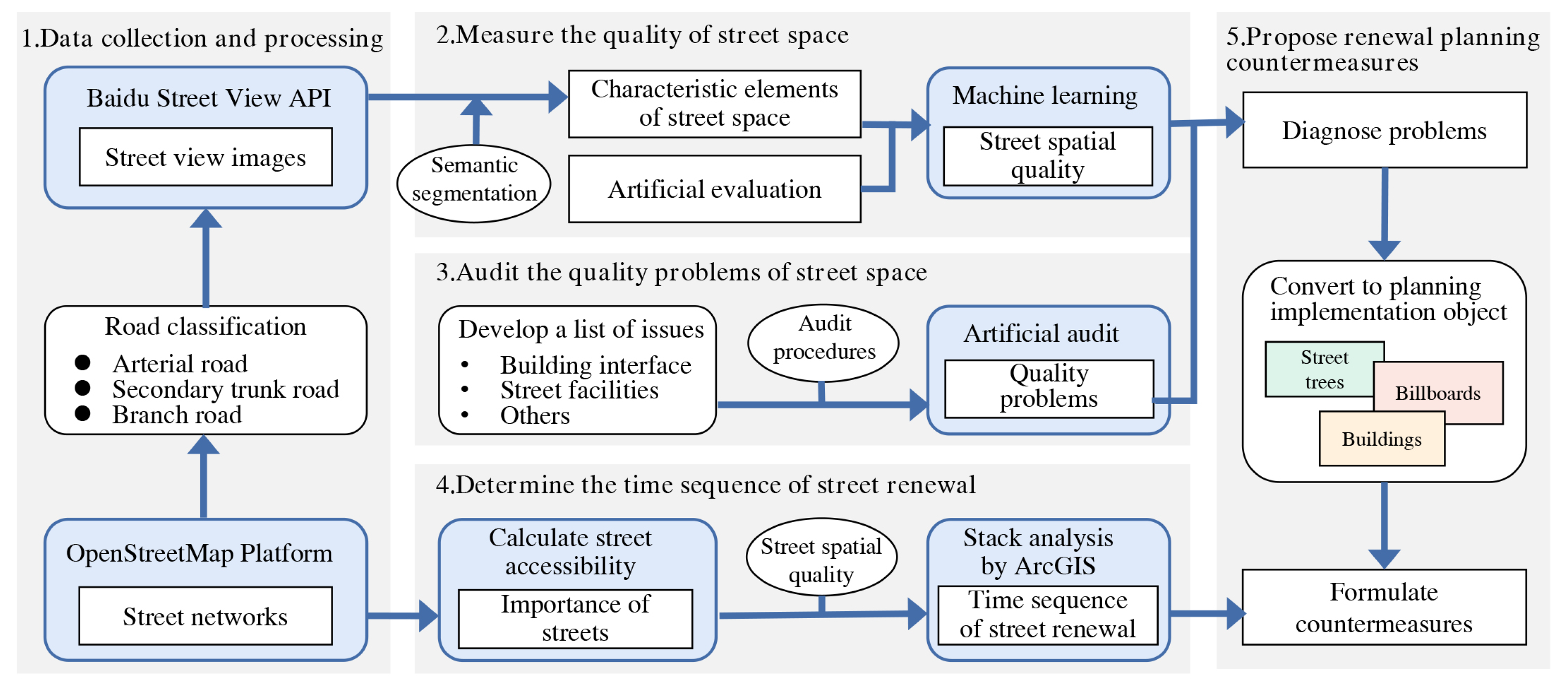
This paper aims to diagnose street spatial quality problems using street view images and machine learning technology and to propose targeted street spatial renewal strategies for these problems, in order to optimize the quality of urban public space and promote sustainable urban renewal. Specifically, after classifying the urban road network, the street view images of arterial roads, secondary trunk roads, and branch roads were obtained. Then, after extracting the sky, trees, buildings, and other scene elements, the street spatial features such as openness, greenery, and enclosure were obtained. According to these feature elements and small-scale subjective evaluation of street spatial quality scores, the machine learning model was trained to achieve a large-scale street spatial quality measurement. Next, further diagnosis of street spatial quality problems was achieved using an artificial audit. Finally, street accessibility was used to determine the importance of the street. The “importance” and the “quality” were analyzed using superposition to further identify the renewal potential of the street and determine the time sequence of street renewal. Based on the problems diagnosed and the updated time sequence, targeted renewal planning countermeasures were proposed. The specific analytical framework is shown in Figure 1.
2.2. Study Area
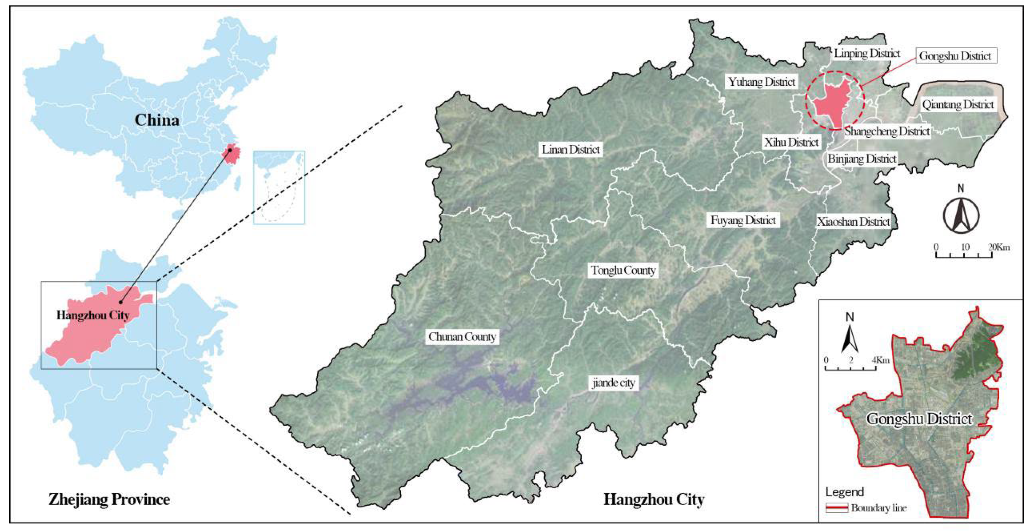
This study was conducted in Gongshu District, Hangzhou, China. Gongshu District, located in the northeastern part of Hangzhou, is a representative old urban area with a total area of 119 km2 in 2022 (Figure 2). The area has the world-class cultural heritage of the Beijing–Hangzhou Grand Canal, industrial relics such as the Hangzhou Dahe Shipyard Complex, and distinctively styled neighborhoods such as the Xiaohe Straight Street. In recent years, facing the problems of dilapidation, lack of spatial vitality, and environmental deterioration in the old city, Gongshu District has been vigorously implementing urban renewal work to reshape the character of the landscape and improve the quality of space. This study selected Gongshu District as a case study. Considering that the perception of street spatial quality is closely related to people’s experience in the space, the arterial roads, secondary trunk roads, and branch roads in the area were taken as the objects, which are connected to living functions. Using the street network, street view images, and other multi-source urban data, this study conducted a large-scale street spatial quality measurement, comprehensively diagnosed the quality problems, and provided targeted planning countermeasures for its accurate renewal. This work can further guide future urban renewal and construction in China.
3. Methodology
3.1. Data Collection and Processing
Baidu Street View has the advantages of strong availability in China, high coverage in the study area, and fast data update speed, so we selected Baidu Street View data for this study. The data were collected in two main steps. One was to extract and classify the street network, and the other one was to obtain the Baidu Street View data.
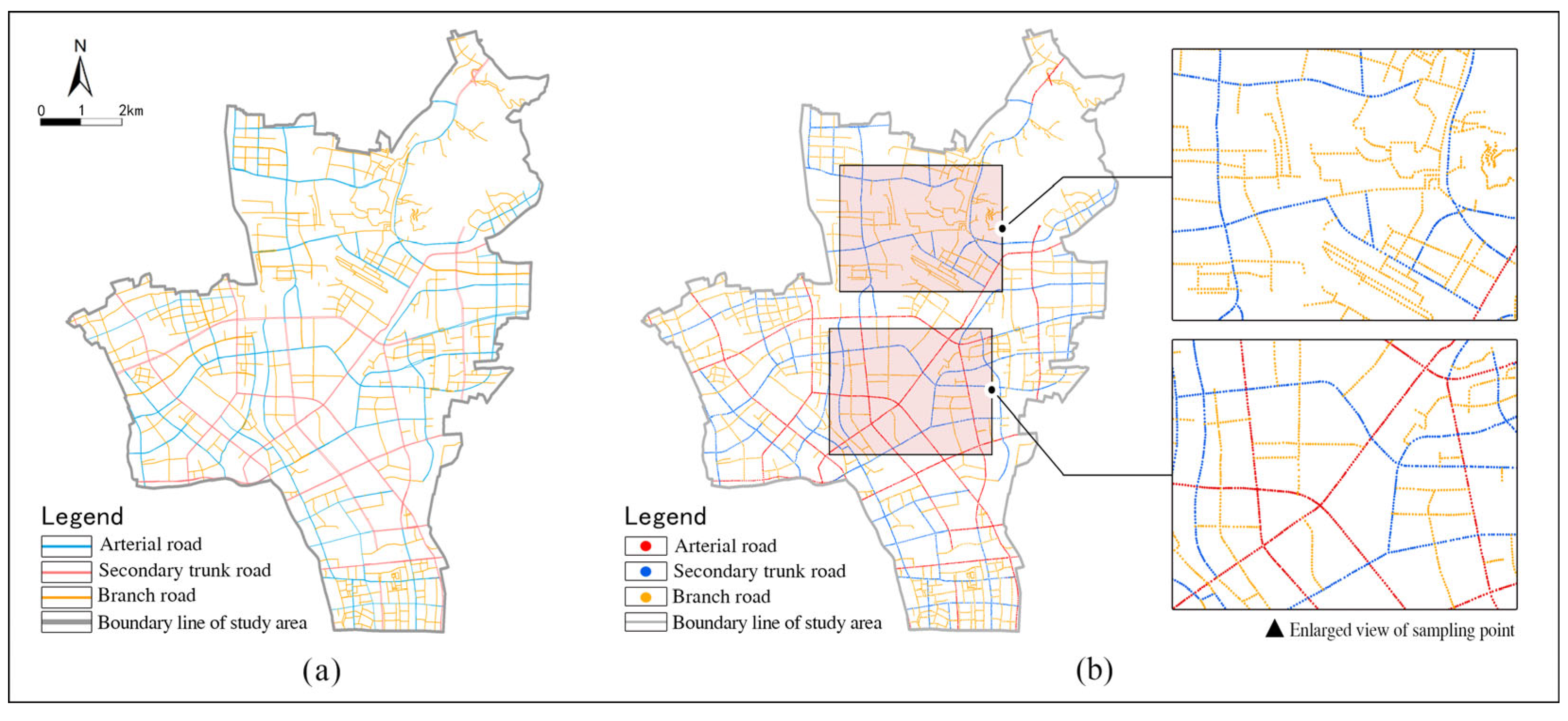
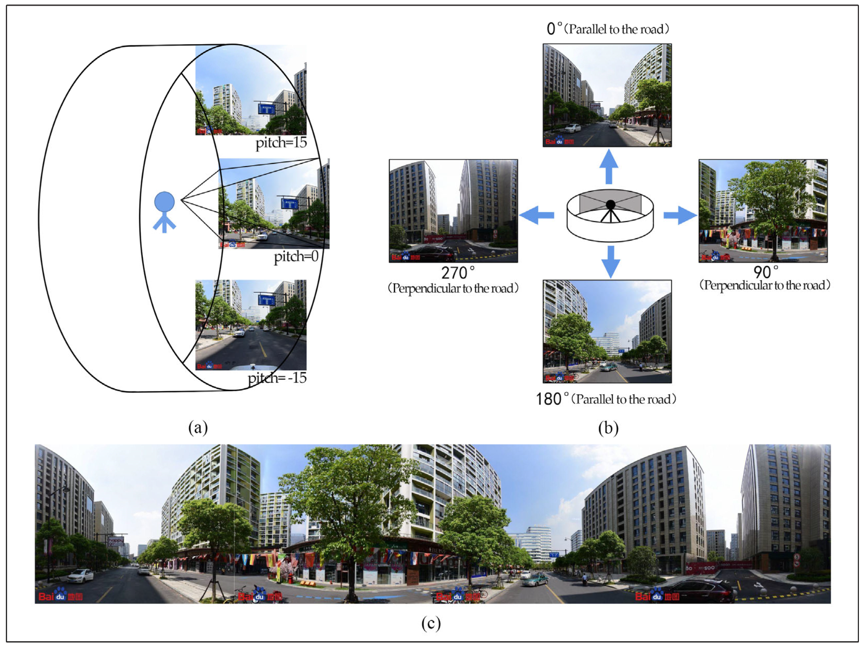
First, based on the contents relevant to road classification in the Urban Comprehensive Transportation System Planning Standard (GB/T51328-2018), three types of data including arterial roads, secondary trunk roads, and branch roads, were obtained using ArcGIS, according to the data attributes of the street network in Open Street Map (Visited in April 2022), as shown in Figure 3a. After the processes of simplifying the road network, correcting the topology, and extracting the center line of the roads, the sampling points of the street view images were determined at an interval of 50 m, as shown in Figure 3b. A total of 11,377 effective street view sampling points were obtained after cleaning, among which the arterial roads, secondary trunk roads, and branch roads contained 2308, 3319, and 5750 points, respectively. Second, the Application Programming Interface (API) of Baidu Street View was called using the application of Python programs, and the horizontal view angle, view width, and sampling point coordinates were input to capture street view images. In order to comprehensively and effectively reflect the real feelings of citizens in the street space, four street view images were collected at each sampling point, each with the 0° horizontal sight line (“pitch” = 0) and 90° visual angle width (“fov” = 90). A total of 45,508 street view images with a resolution of 600 × 480 pixels were collected as the data source for evaluating the quality of street space. This included the front and back street view images that were parallel to the road and the left and right street view images that were perpendicular to the road, which can together form a panorama (Figure 4).
3.2. Measuring the Quality of Street Space
The main purpose of measuring the quality of street space is to find the major problems related to street spatial quality. The RF regression model in machine learning can analyze the relationships between street spatial characteristic element indicators and the quality scores, and then identify the feature factors that have a significant influence on the spatial quality of streets at different grades. As such, it can play an important guiding role in identifying the key problems related to street spatial quality.
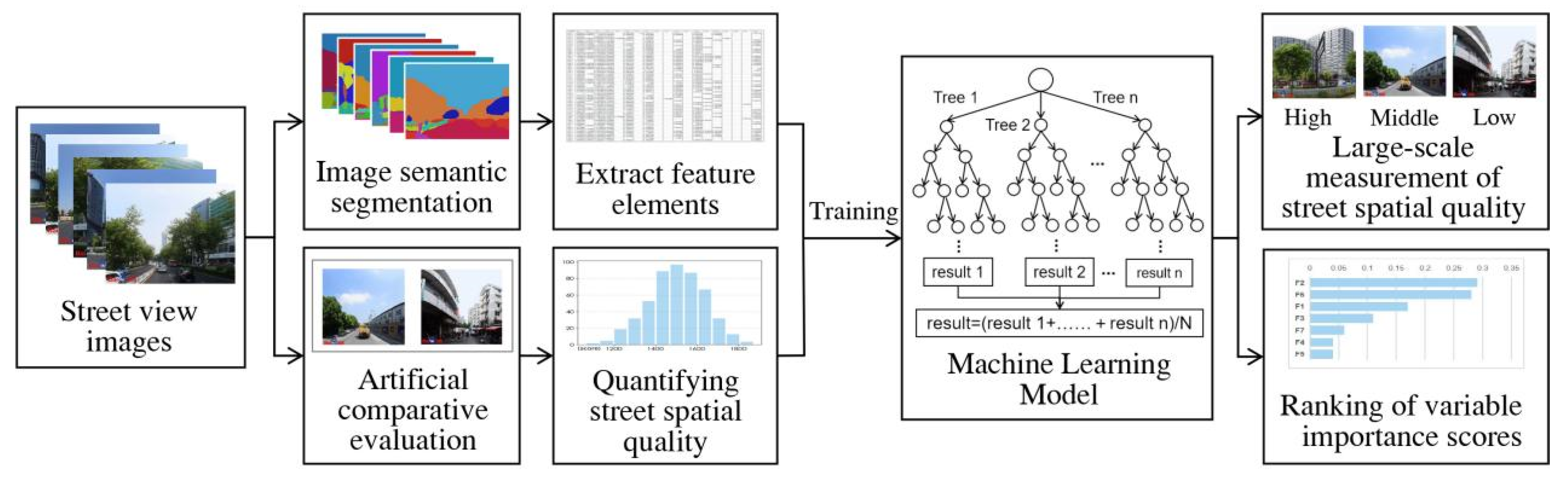
For this study, a framework was designed to measure and analyze the spatial quality of streets at different grades, which included the extraction of feature elements, a small-scale artificial comparison and evaluation of street view images, and the application of the RF algorithm [37] (Figure 5). Using the street space as the research object, based on the street view images, on the one hand, image segmentation technology was applied to extract the street spatial characteristic elements. On the other hand, a certain number of sample images were evaluated manually, and the street spatial quality scores were quantified with the corresponding scoring algorithm. Subsequently, the RF models for arterial roads, secondary trunk roads, and branch roads were trained using the feature element values and the quality scores of the sample images, which can quickly realize the large-scale street spatial quality measurement.
3.2.1. Extracting Street Spatial Feature Elements
Image semantic segmentation is an important branch in the field of artificial intelligence, and it is also one of the major links in the application of image processing and machine vision technology. Semantic segmentation is a method of region division, which can classify every pixel in an image and determine its categories, such as identifying cars, buildings, and pedestrians. Long et al. [38], of the University of California, Berkeley, proposed the Fully Convolutional Network (FCN) for image segmentation, which has since become the basic framework for semantic segmentation.
Considering that FCN image segmentation technology has an excellent recognition effect in exploratory applications in Chinese cities [31,39,40,41], this study used FCN [31] to analyze street view images in order to identify elements such as buildings, sky, and plants. The occurrence frequencies of the characteristic elements in the existing related studies were translated into spatial objects that can be intervened using urban planning. Seven characteristic element indices of street space, including the green-looking ratio, street openness, interface enclosure, degree of road motorization, the proportion of street facilities, the richness of street color, and the proportion of pedestrian space, were selected for calculation and analysis in order to explore the elements and mechanisms affecting the street spatial quality (Table 1). Among them, the degree of road motorization was used to represent the traffic characteristics of the street, which is usually related to the occurrence rate of cars, the layout, and the pavement of the bottom interface of the street space. Subtract sidewalk pixels from the sum of vehicle roads and motor vehicles pixels, and the ratio of the calculated value to the street view image pixels is expressed as the degree of road motorization [24,42]. To some extent, the richness of street color can reflect the visual complexity of the street space and the diversity of the constituent elements. Therefore, the diversity of street spatial element types was used to represent the street color richness, which was calculated using the Simpson index. The other indicators were calculated as the ratios of the corresponding street view elements to the total number of pixel points.
3.2.2. Artificial Comparison and Evaluation of Street View Images at a Small Scale
In this study, a small sample of the evaluation data on street spatial quality related to human subjective perceptions was used as the training dataset, in order to predict the scores of the street spatial quality at a large scale. In the sampling evaluation, the street view images with better spatial quality were selected and ranked using pairwise comparison, and the ranking was converted into street spatial quality scores in a certain way. At present, the ELO rating system has become an accepted and authoritative method for assessing the level of play, which is commonly used to measure the ratings of players in various types of activities, such as chess [43]. Considering the advantages of this system, such as concise evaluation requirements, avoiding differences caused by different scoring systems, and reflecting the subjectivity and comprehensiveness of scoring, some scholars have introduced this system into the quality evaluation of the urban built environment and achieved certain research results [30], which can better guide this study. Therefore, in terms of small-scale artificial evaluation of street view images, this study equally selected the ELO scoring system for evaluation.
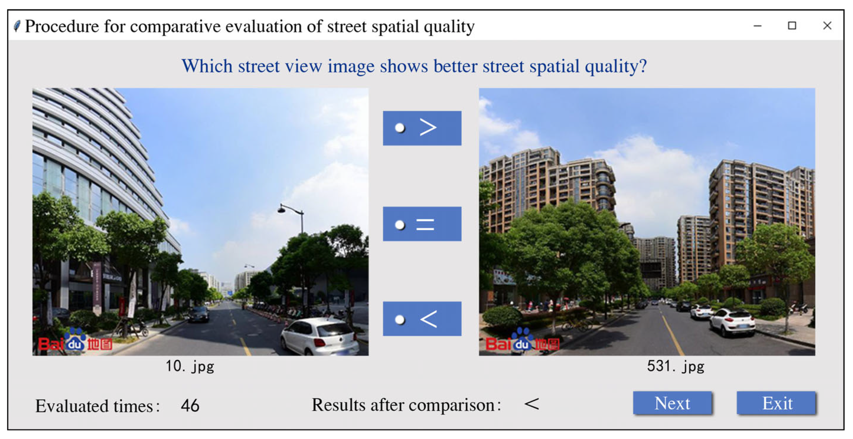
The overall idea of the evaluation is to assign an initial score to the street view images, predict the probability that the image with better quality can win using the comparison judgment, and then update the quality scores of the street view images according to the final result. Using several rounds of comparisons, the scores of street view images are constantly updated. When the number of comparisons reaches a certain amount, the ranking of street view images tends to be stable, which means the quality scores close to the real level of street view images can be obtained. First, among the 45,508 street view images, 500 images were randomly selected from each of the arterial roads, secondary trunk roads, and branch roads as samples, and they were spatially positioned in ArcGIS to ensure that the spatial distribution of the samples was decentralized and representative. Second, the Python language was used to compile an evaluation application program for the comparison of street spatial quality (Figure 6), and 10 volunteers majoring in urban planning were invited to make comprehensive judgments on street view images at different grades. Finally, the initial score of each sample image was set as 1500, and the results of the pairwise comparison and judgment were converted into quality scores of the sample images using the ELO algorithm. After several comparisons, the final quality scores of all sample images were obtained when the score ranking tended to be stable.
3.2.3. Measuring the Quality of Street Space using Machine Learning
RF is a flexible and easy-to-use machine learning algorithm consisting of multiple decision trees, which is often used for the prediction of data results and has a greater advantage in measuring the relative importance of each feature with respect to the result [44,45]. In order to measure the spatial quality score of streets on a large scale and effectively identify the importance of feature elements, as well as to cope with the differences in the composition of street view elements of streets at different grades, the RF algorithm was used to measure the street spatial quality in the study area.
Based on the principle of the RF algorithm, this study adopted the following steps to build RF regression models for arterial roads, secondary trunk roads, and branch roads which, in turn, could then be used to measure the spatial quality evaluation scores of streets at different grades. First, the street spatial characteristic element values and the quality scores of sampling evaluation were taken as independent variables and dependent variables, respectively. After the variable data was standardized, it was divided into training and test sets at a ratio of 7:3. Second, the Bootstrap sampling method with put back was adopted in order to form N regression decision trees, and targeted training for the RF regression model at a single street grade was carried out. Finally, the average value of the prediction results of all regression decision trees was calculated, and the evaluation scores of the street spatial quality were obtained. The quality score of the same street point was taken as the average of the evaluation scores for the four street view images. For streets of the same grade, the scores of the street spatial quality were sorted from high to low, and the street quality was classified as "high, medium, and low" using one-third of the score ranking as the dividing point. In order to effectively identify the feature elements that have a significant impact on the street spatial quality, the importance scores of the feature elements of arterial roads, secondary trunk roads, and branch roads were calculated and ranked using the RF algorithm.
3.3. Auditing the Quality Problems of Street Space
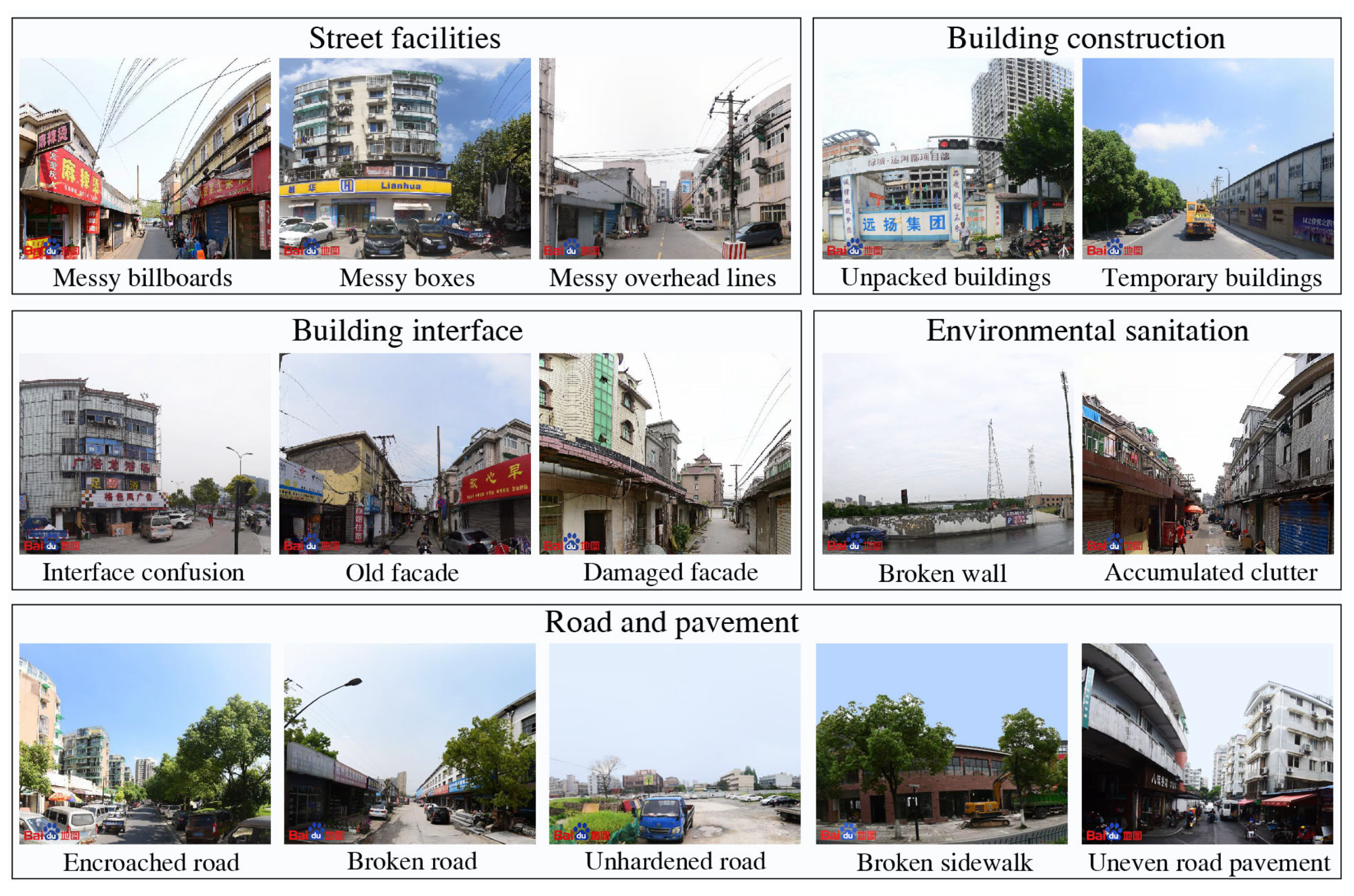
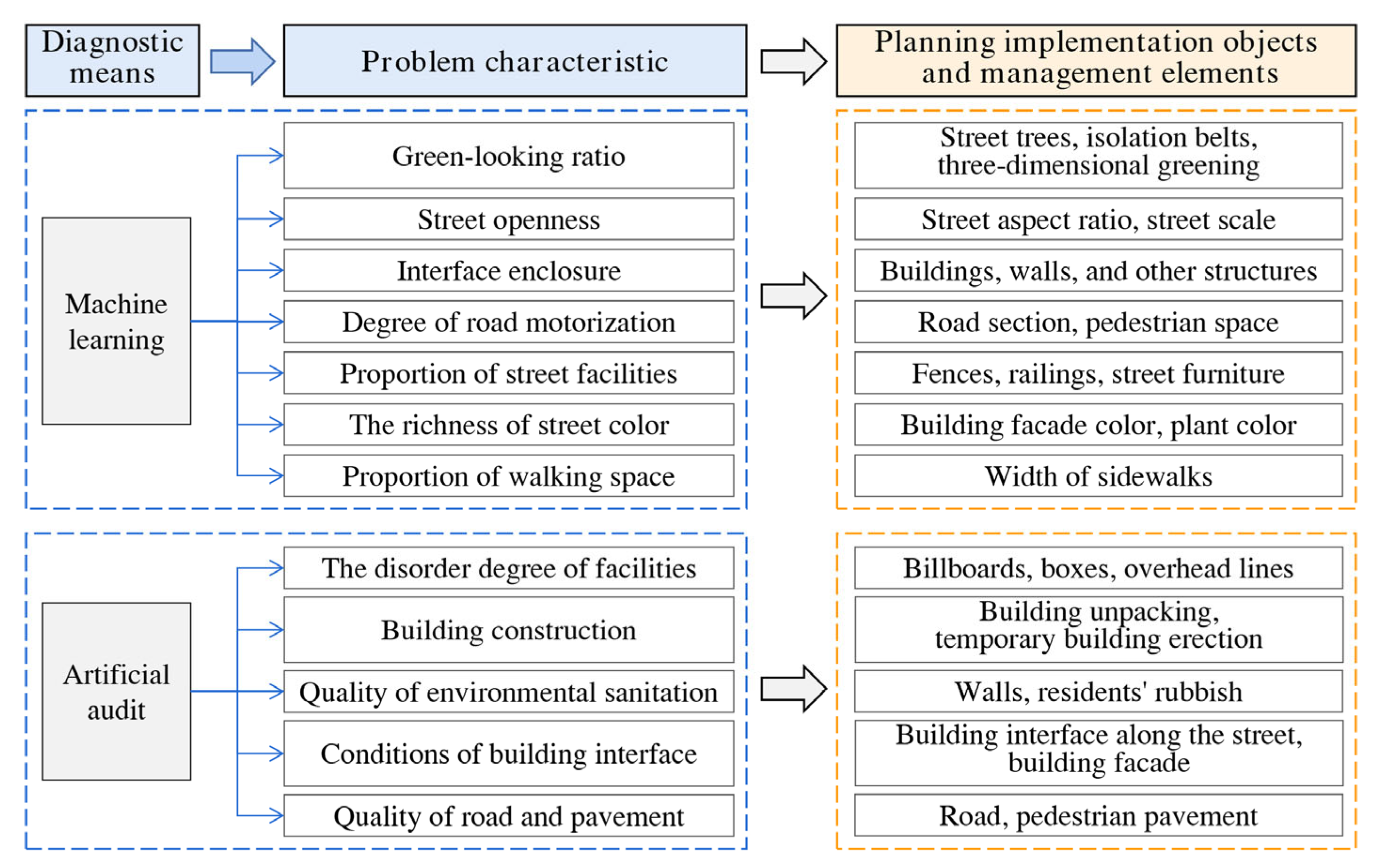
From the perspective of street spatial renovation and management, a list of quality problems was compiled according to the results of the street spatial quality measurement and interviews with experts and residents (Table 2). These mainly involved five aspects, including street facilities, building construction, environmental sanitation, building interface, and road and pavement (Figure 7).
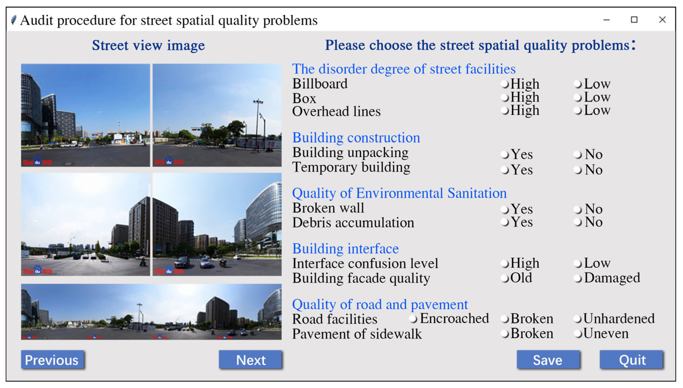
In this study, artificial audit refers to a method in which researchers directly and systematically observe the spatial characteristics of the study area, and then evaluate the urban built environment according to subjective judgment. In the diagnosis of street spatial quality problems, simply using the machine learning method cannot fully take into account the diagnosis of quality problems that are closely related to the daily life of residents. Therefore, it is necessary to supplement it with an artificial audit to improve and optimize the diagnosis method, thus realizing the comprehensive diagnosis of street spatial quality problems. In order to improve the working efficiency of the artificial audit, the online audit procedure was compiled in the Python language according to the list of street spatial quality problems (Figure 8). The four directions of street view images for each street view observation point were concentrated on one page, and the quality problems in the four pictures were checked using options presented on one side. The audit work was focused on streets with medium and low spatial quality in order to achieve a qualitative analysis of quality problems. For this kind of quality problem, we can further judge whether these problems are the main quality problems of the street space by counting their frequency.
3.4. Determining the Time Sequence of Street Renewal
In the field of urban planning, street accessibility is typically used to characterize the magnitude of opportunities for nodes in urban street transportation networks to interact with each other, and there have been many studies on relevant evaluation methods [46,47]. At present, the Spatial Design Network Analysis (sDNA) method is frequently introduced into street accessibility studies due to its simplicity, ease of use, and strong operability [48,49]. It can analyze the accessibility of the road network using a calculation of the use potential of street walking, motor vehicles, bicycles, and public transportation, and is widely used in different spatial networks such as urban roads, three-dimensional walking spaces, and so on. The sDNA approach takes closeness and betweenness as computational metrics to analyze a street network [49]. Closeness refers to the degree of difficulty when going from a point in the street network to other points within the search radius. Betweenness is used to measure the frequency of path selection in the street network [48], which can reflect the relationship between the overall space and local space, and the higher the betweenness, the higher the accessibility [46,47].
Therefore, to a certain extent, measuring street accessibility according to the betweenness can reflect the frequency and importance of street paths used in the whole street network. A higher betweenness means stronger accessibility of the street, which also means that the street is more important and selected more frequently in the process of public passage. Simultaneously, a lower evaluation score of a street means that the necessity of street spatial quality improvement is higher. In order to identify the importance of streets, based on the street network data, this study used the sDNA tool in the ArcGIS platform to calculate the betweenness of the arterial roads, secondary trunk roads, and branch roads. This mainly included the steps of “Prepare Network” and “Integral Analysis” in the tool, and the analysis was carried out in terms of metric distance variation, which measures the frequency of path selection and traffic potential in the street network [30]. For streets at the same grade, the median value of the betweenness was used to distinguish "high-importance" and "low-importance" streets.
Next, the importance and quality of streets were analyzed using superposition. Taking “importance–quality” as the evaluation dimension, several types of street importance were obtained: High importance and high quality, high importance but low quality, low importance and low quality, and low importance but high quality. As a result, streets with further potential for renewal were identified in order to determine the street renewal time sequence, which can provide orderly work arrangements for urban renewal and effectively guide the implementation of spatial planning.
3.5. Proposing the Planning Countermeasures for Street Spatial Renewal
The purpose of this study consisted of two parts, one was to realize the diagnosis of street spatial quality problems at a large scale, while the other was to propose specific targeted strategies for the renewal planning of street space. In the first part, this study clarified the major and minor issues of street spatial quality using feature importance extraction of the RF model, which provided certain data support for determining the priority of updating spatial elements in street renewal planning. Using the addition of the artificial audit link of street spatial quality problems, it supplemented the diagnosis of quality problems closely related to the lives of residents. Meanwhile, the statistical analysis of various types of problems clearly indicated the major and minor conflicts of these issues. We hope that this study helps to solve most of the problems with limited energy, thus maximizing work efficiency and optimizing the final effect.
Therefore, it is not necessary to optimize all measurement indicators and spatial elements to improve the quality of street space. Instead, it is more important to put forward key updating countermeasures against the relevant indicators and quality problems that are closely related to the quality evaluation results as much as possible, in order to achieve the effect and goal of optimizing the overall street spatial quality. Based on defining the quality issues of street space, this study translated the quality problems into operational elements in urban planning and construction management (Figure 9). For example, the problem of the green-looking ratio was translated into street trees, isolation belts, and three-dimensional greening in street space. Finally, in order to further promote the orderly development of relevant work, such as street renewal and renovation, this study put forward targeted planning suggestions for the renewal and reconstruction of streets at different grades according to the important quality problems and the time sequence of street renewal.
4. Results and Countermeasures
4.1. Measurement and Classification of Street Spatial Quality
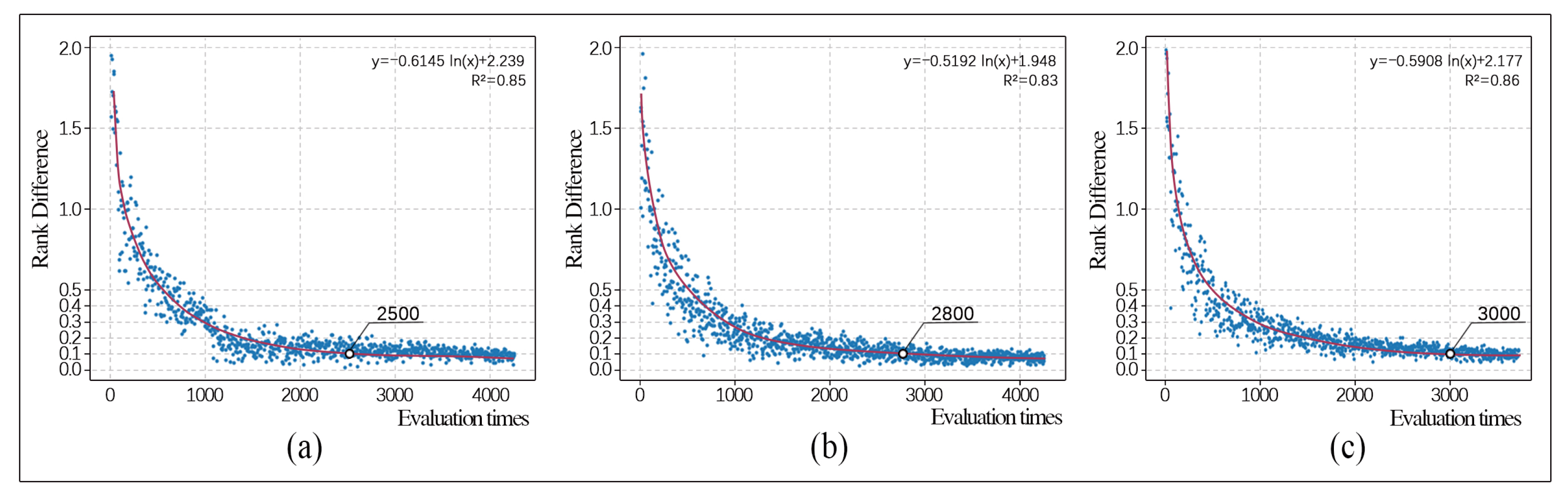
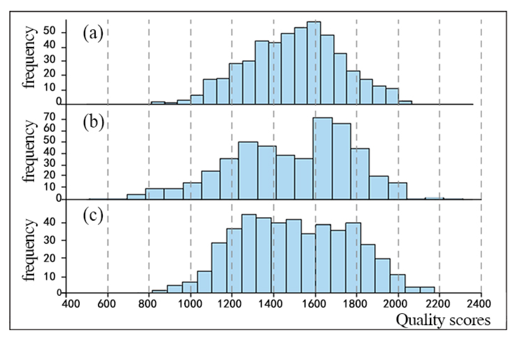
In the sampling evaluation link, this study invited each volunteer to conduct 500 comparison judgments of streets at the same grade. The rank difference values were calculated after each comparison, and a scatter plot was drawn using the average value from a group of five comparisons. The vertical axis represents the average rank difference value for the five comparisons, and the horizontal axis is the number of comparisons. According to Figure 10, the rank difference value shows a logarithmic decreasing trend as the number of comparisons increased. When the evaluation number of comparisons for arterial roads, secondary trunk roads, and branch roads reached about 2500, 2800, and 3000, respectively, the ranking of scores tended to be stable, and the rank difference value was basically below 0.1. The final quality scores of all sample images were obtained (Figure 11).
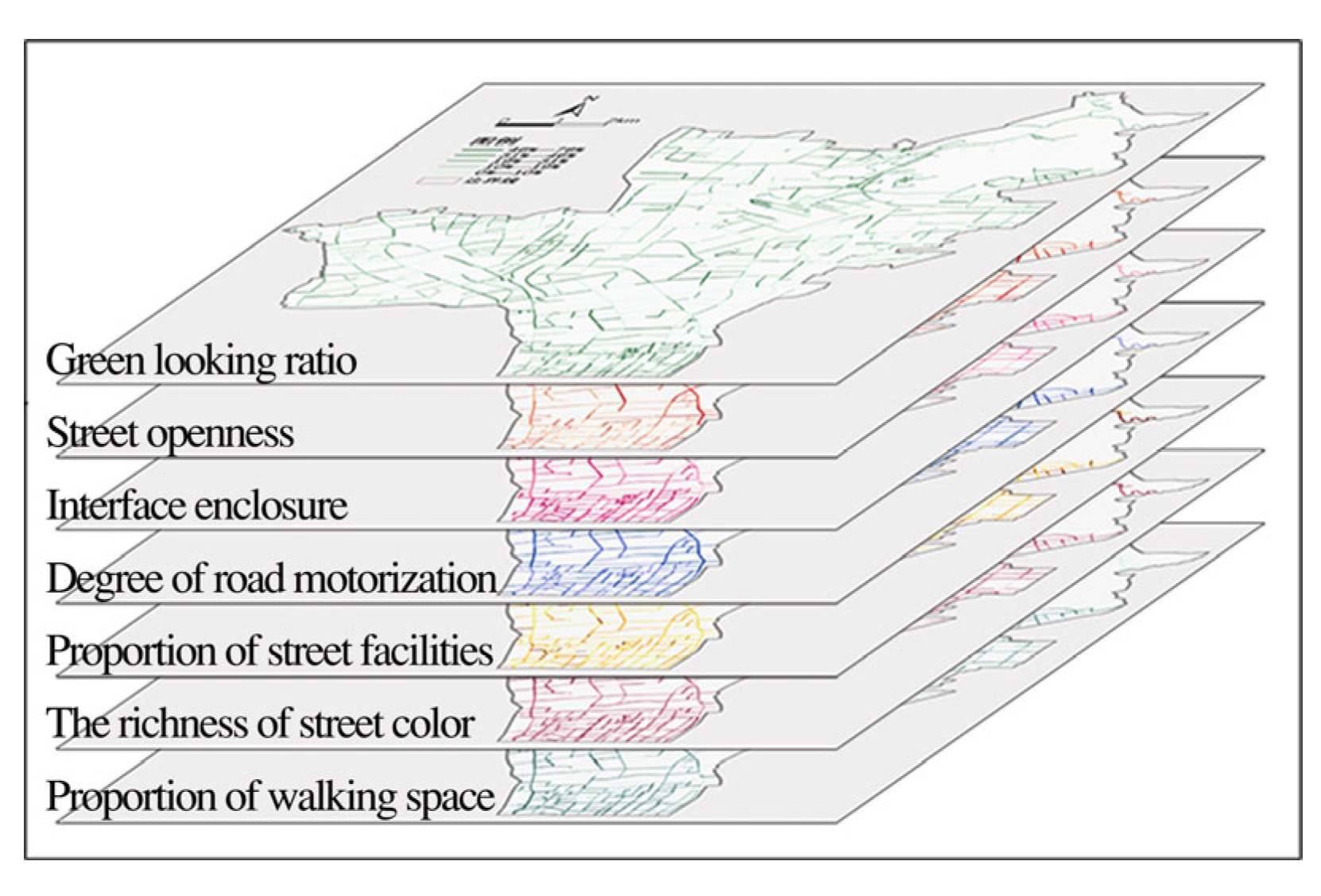
The values of the seven street spatial characteristic element indicators were input into the RF regression model after data standardization (Figure 12), and RF training of streets at different grades was carried out. According to the error and precision of each round of training, it was found that when the number of decision trees selected for arterial roads, secondary trunk roads, and branch roads was 100, 150, and 150, respectively, and the minimum number of samples split by internal nodes and for each leaf node were both 2, the total error of the model tended to be stable. That is, under these settings, the model training based on the RF regression algorithm had a good effect. Specifically, in the RF model of streets at three grades, the determination coefficient (R2) of the training set was above 0.83, and the R2 of the test set was above 0.82. This means that the established RF regression algorithm fit the relevant data well, and there was a high correlation between the actual value and the predicted value of the model. Compared to the training and test sets for the same model, the difference in the model evaluation index values was small, indicating that the model presented no over-fitting phenomenon and had a strong generalization ability. The final results showed that the accuracies of the arterial roads, secondary trunk roads, and branch roads models were all higher than 80%, representing that the model had strong applicability and effectiveness in the measurement of street spatial quality.
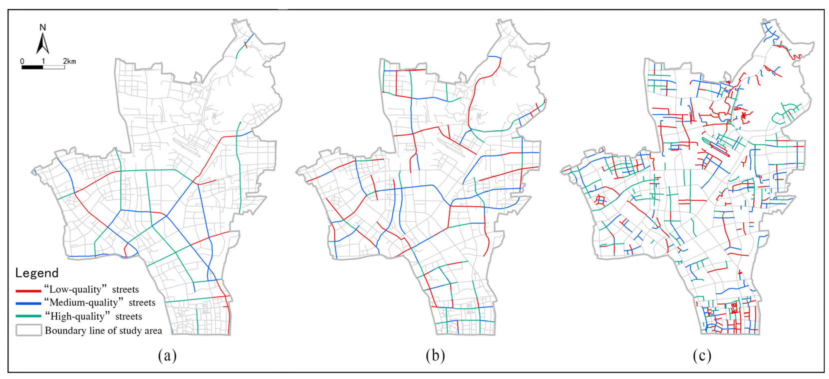
After data standardization, the trained RF regression model was used to predict the spatial quality scores of streets at different grades. Finally, the quality scores of each sampling point were obtained. According to the measurement results, the score range of street spatial quality in Gongshu District was 0.172–0.906, with an average value of 0.593. The quality score of arterial roads ranged from 0.172 to 0.906, with an average value of 0.634. The score of secondary trunk roads was 0.210–0.808, with an average of 0.559. The score of branch roads was 0.196–0.861, with an average of 0.596 (Table 3). Finally, the spatial quality scores of the arterial roads, secondary trunk roads, and branch roads were ranked from high to low. Using 1/3 of the score ranking as the dividing point, the spatial quality of streets was divided into three categories—high, medium, and low—and visualized using ArcGIS, as shown in Figure 13.
4.2. Diagnosis of Street Spatial Quality Problems
4.2.1. The Overall Characteristics of Street Spatial Quality Problems
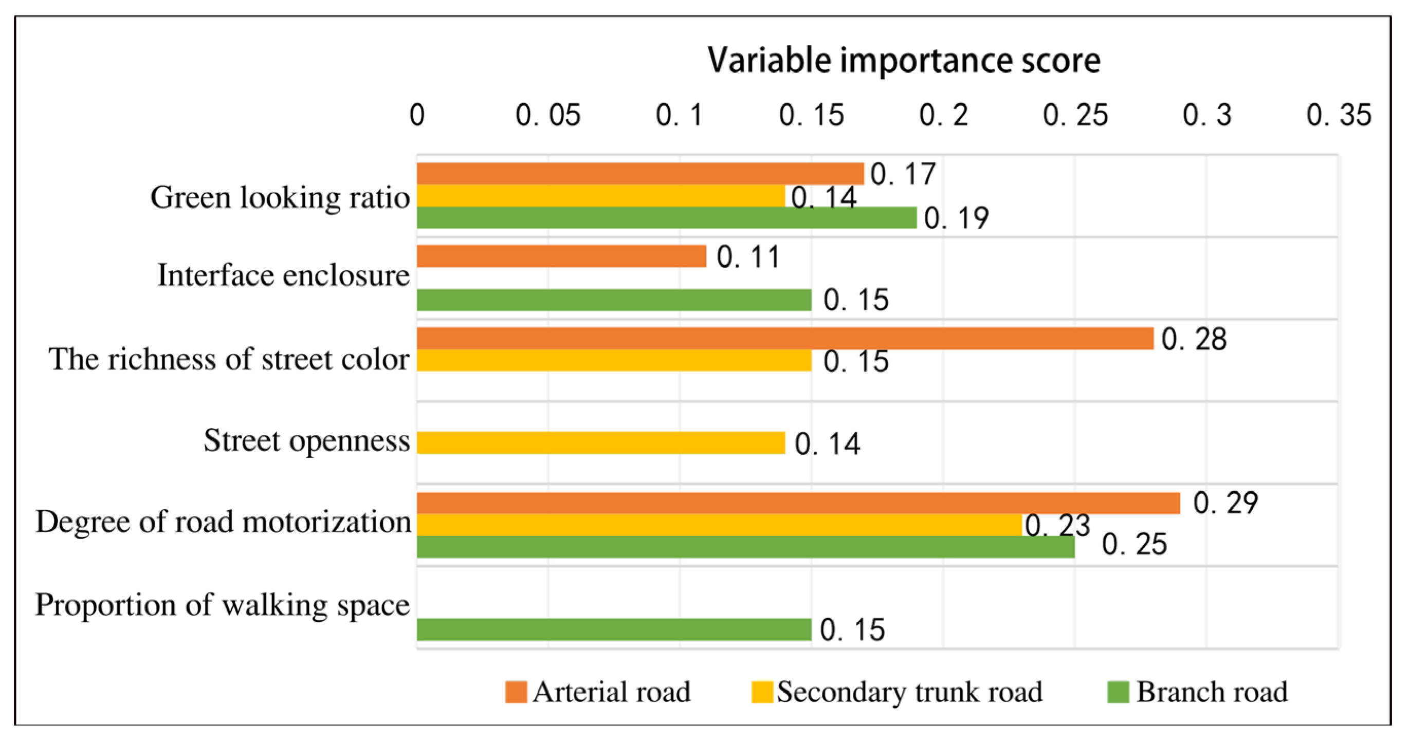
According to the analysis results of the variable importance obtained using the RF algorithm, the green-looking ratio and the degree of road motorization had an important influence on the three types of streets; the richness of street color had a significant effect on the spatial quality of arterial and secondary trunk roads; the interface enclosure had a certain impact on arterial and branch roads; and the street openness and proportion of walking space had a greater influence on secondary trunk roads and branch roads, respectively (Figure 14). Therefore, the impact of street spatial characteristics elements on the quality of streets at different grades presented large differences. In the actual renewal planning, targeted strategies should be designed using a combination with the characteristics of various street spatial quality problems.
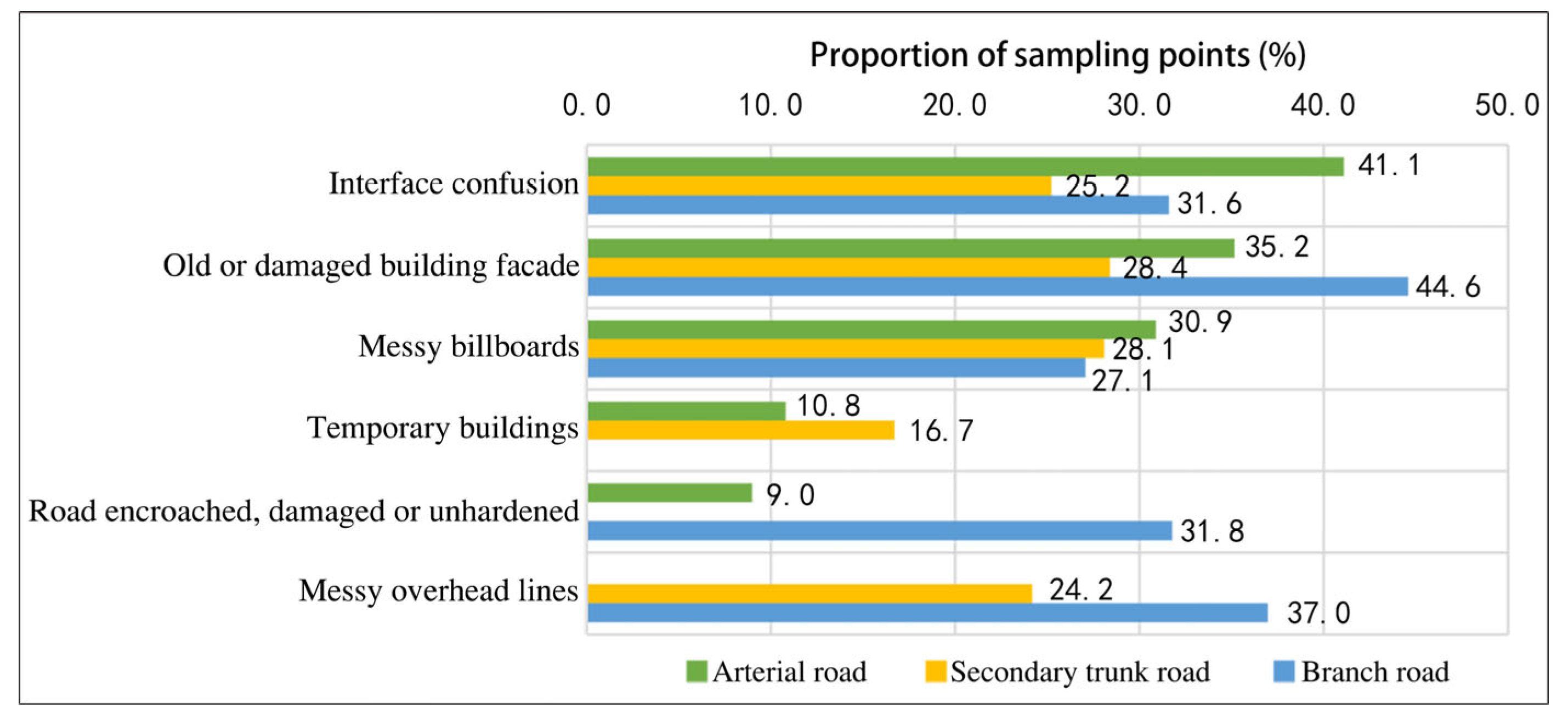
Based on the audit results of street spatial quality problems, there were common issues with building interfaces (interface confusion, old or damaged building facade) and street facilities (messy billboards) in the three types of streets (Figure 15). The construction of temporary buildings occurred frequently in the arterial and secondary trunk roads, and the disorder of overhead lines mainly existed in the secondary trunk and branch roads. The problems of encroachment, damage, and unhardened road facilities were more serious on the arterial roads and branch roads. Therefore, the quality problems of street facilities, building interfaces, and roads were generally prominent. The other quality problems differed with respect to streets at different grades, and thus need to be improved according to the actual situation.
4.2.2. Characteristics of Quality Problems in Streets at Different Grades
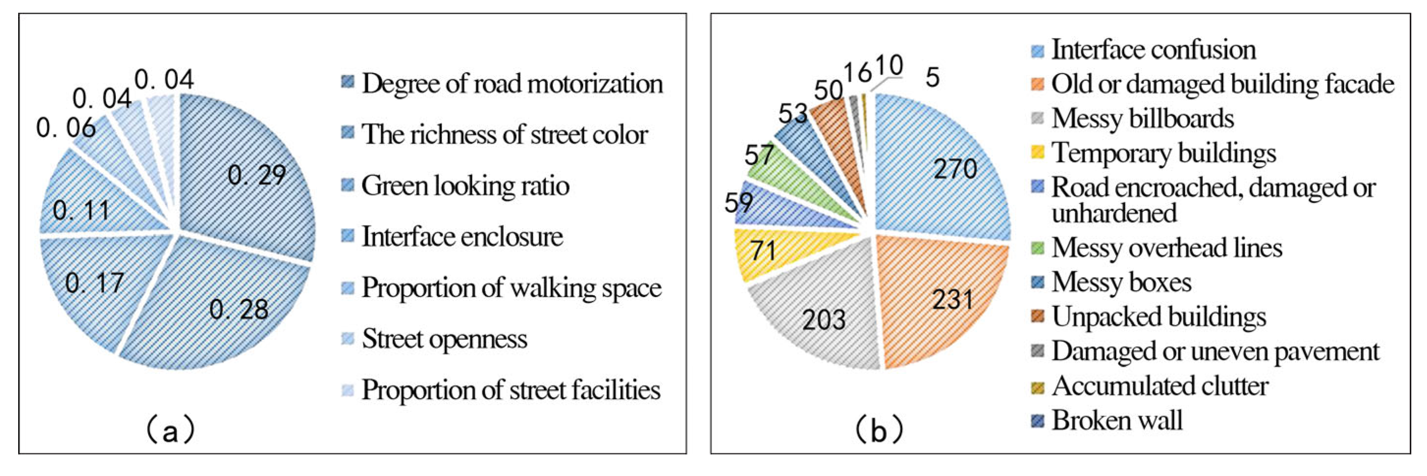
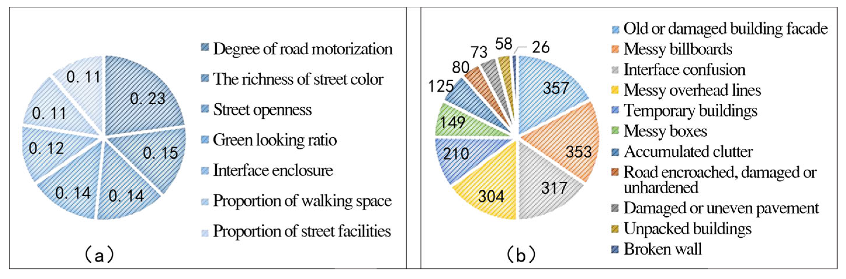
Arterial roads: It can be seen, from Figure 16, that the importance scores for the degree of road motorization, the richness of street color, the green-looking ratio, and interface enclosure were higher, which means these feature elements have a greater impact on the quality of street space. According to the list of street spatial quality problems, there were 657 sampling points with problems in arterial roads, accounting for 28.47%. The outstanding quality problems mainly included interface confusion, old or damaged building facades, messy billboards, temporary buildings, and road facilities that were encroached, damaged, or unhardened.
Secondary trunk roads: It can be seen, from Figure 17, that the importance scores of the degree of road motorization, the richness of street color, street openness, and the green-looking ratio were higher, indicating that these feature elements had a significant impact on the street spatial quality of secondary trunk roads. From the list of quality problems, there were 1257 sampling points with problems in secondary trunk roads, accounting for 37.87%. The outstanding quality problems mainly included old or damaged building facades, messy billboards, interface confusion, messy overhead lines, and temporary building construction.
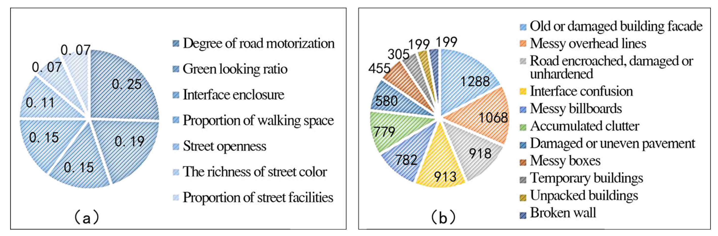
Branch roads: It can be seen, from Figure 18, that the importance scores of the degree of road motorization, the green-looking ratio, interface enclosure, and the proportion of walking space were higher, which means these feature elements had a greater impact on the street spatial quality. From the list of quality problems, 2889 sampling points in the branch roads had problems, accounting for 50.24%. The outstanding quality problems mainly included old or damaged building facades, messy overhead lines, road facilities that were encroached, damaged, or unhardened, interface confusion, and messy billboards.
4.3. Street Spatial Renewal Planning
4.3.1. Time Sequence of Street Renewal
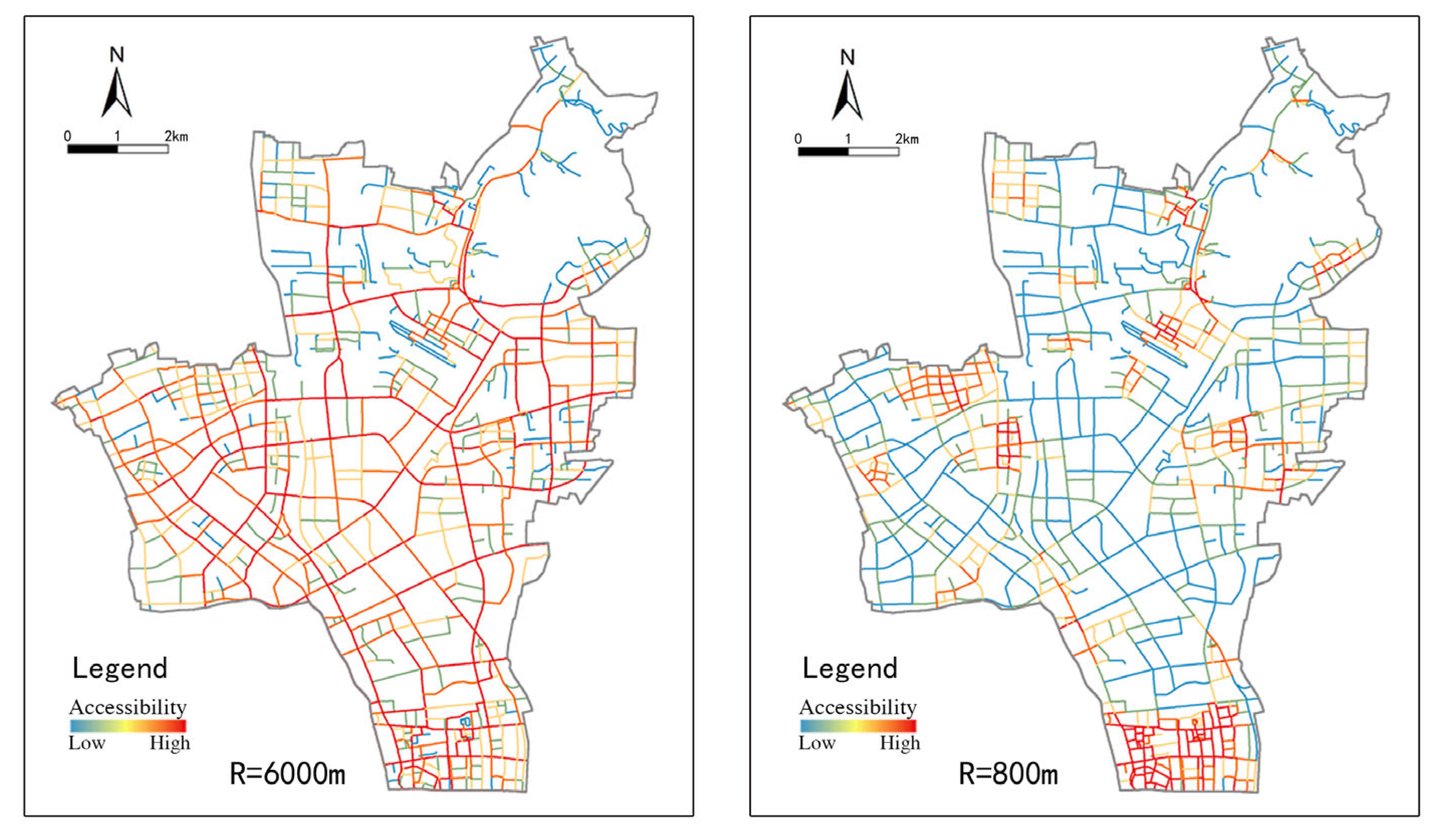
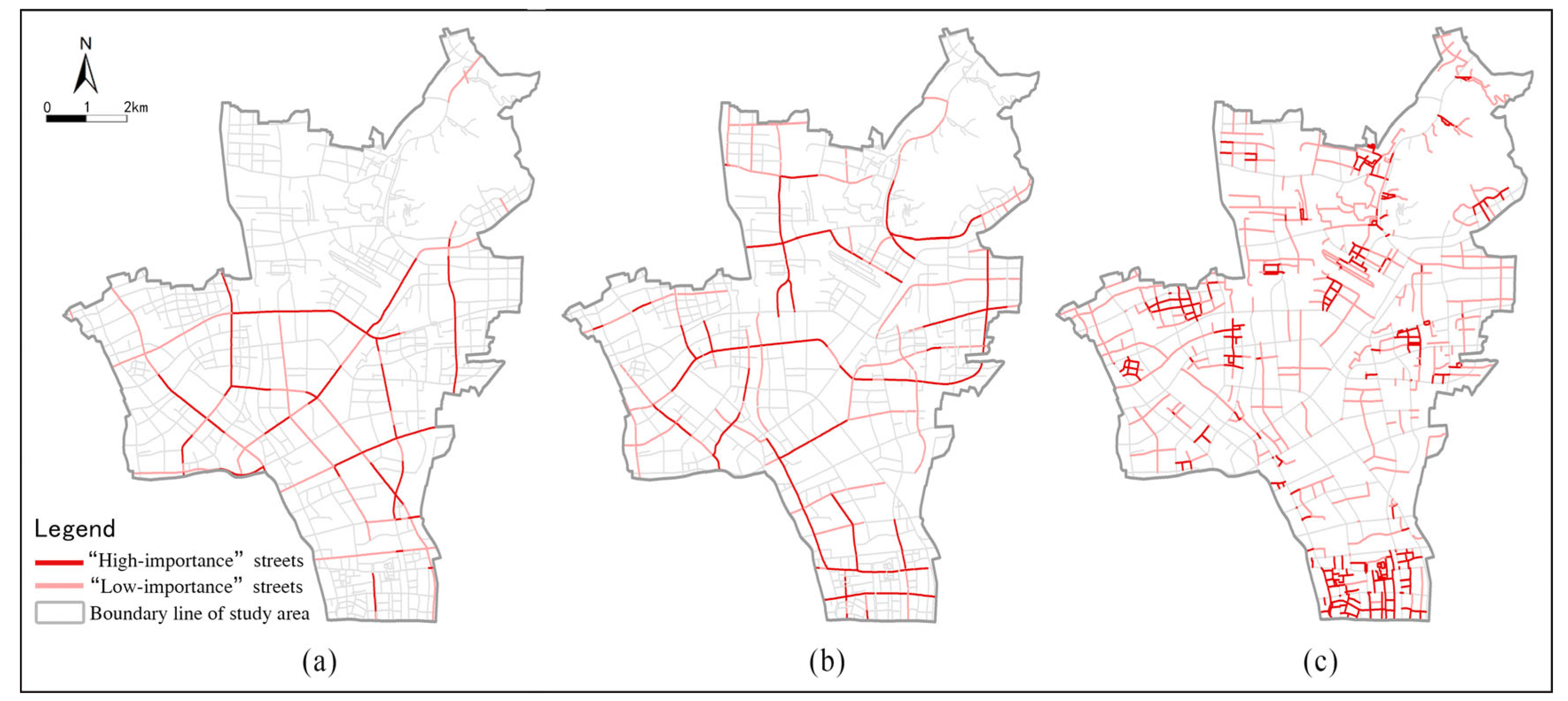
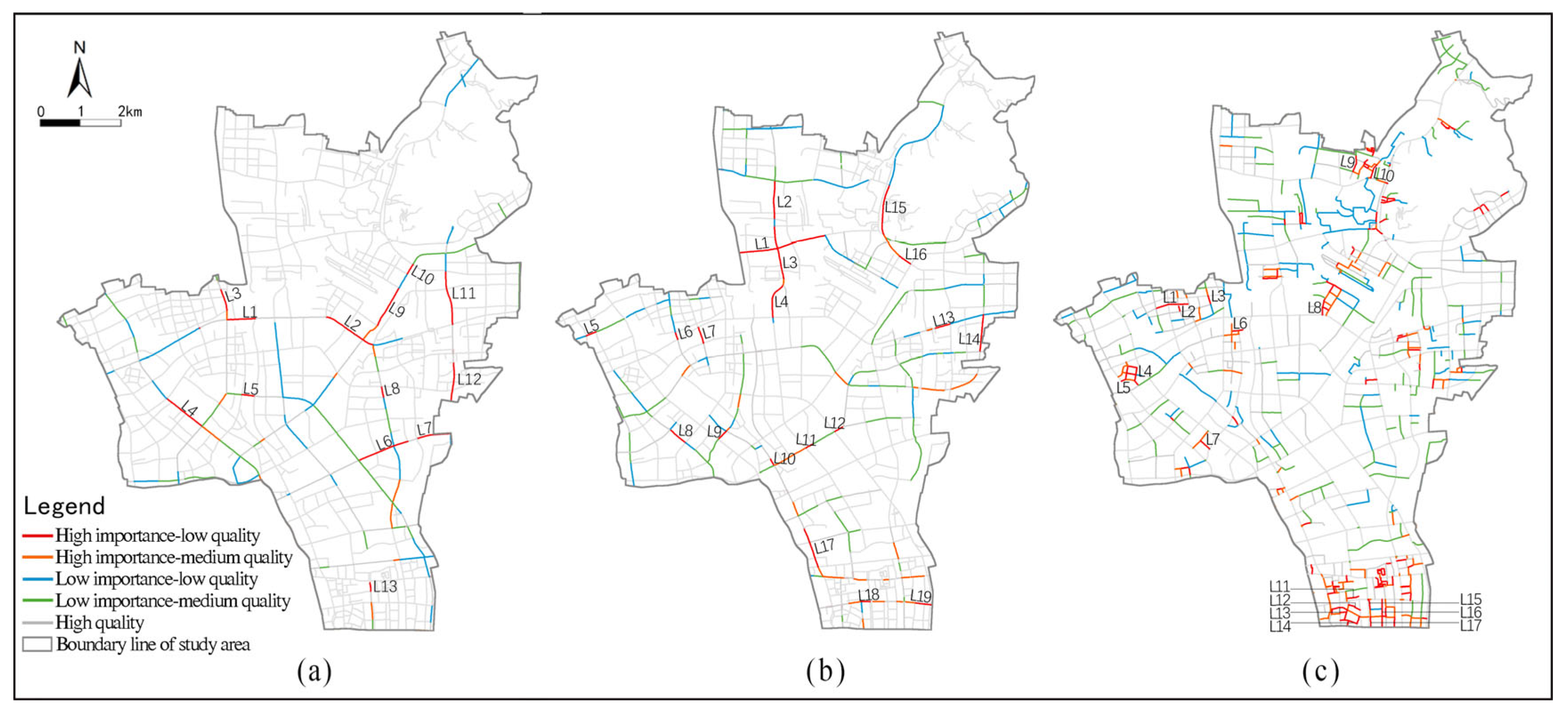
In the sDNA, the calculation results regarding street accessibility under different measurement radii represent the different degrees of residents’ choice of road. According to the daily travel situation in Hangzhou and relevant research results [48,50], 6000 m and 800 m were selected as the measurement radii of daily commuting and walking travel, respectively, to calculate street accessibility (Figure 19). Considering that the functional characteristics of streets at different grades have certain differences, the street importance of arterial and secondary trunk roads was identified according to commuting accessibility, and the importance of the branch roads was identified using walking accessibility (Figure 20). Based on the superposition result of “importance and quality”, the streets with poor quality that are frequently used by residents in daily life should be given priority to be updated recently; that is, “high importance—low quality” streets. Then, the “high importance–medium quality” streets should also be renewed (Figure 21).
4.3.2. Planning Countermeasures for Street Spatial Renewal
The implementation of street spatial renewal planning is bound to be a process of phased and classified implementation. On the one hand, according to the updated time sequence of streets at different grades (Figure 21), the renewal planning of streets can be carried out in an orderly manner. On the other hand, in the process of renewal of streets at the same grade, key quality issues should be considered for priority improvement. That is, we should focus on the characteristic elements that have a great impact on street quality, as well as the outstanding quality problems of the street space, in order to improve the efficiency of street spatial renewal and optimize the effect of renovation.
Based on the renewal time sequence of streets at different grades and the diagnosis results of street spatial quality problems, highly targeted renewal strategies were formulated to achieve the precise renewal of streets. Starting from the priority streets for renewal in the dimension of “high importance–low quality”, using three types of street space including arterial roads, secondary trunk roads, and branch roads as examples, according to the principle and means of “precise renovation”, this study made targeted planning recommendations for street space in order to further assist the planning decisions related to urban renewal in Gongshu District.
Arterial roads: A total of 13 street sections, such as L1 (Shixiang Road: Tongyi Road-Lishui Road Section), should be given priority for renewal, as shown in Figure 21a. In the aspect of optimizing the characteristic elements of street space, the focus should be placed on reducing the degree of motorization using bicycle lanes, widening pedestrian spaces, and implementing a variety of speed reduction measures to improve the safety of streets. According to the dominant color of buildings along the street, the color of the building facades, billboards, and other elements should be adjusted and controlled appropriately. Measures such as making full use of the street buffer zone and green isolation belt should be taken to improve the green-looking ratio. The nature of the land around the street should be compatible and mixed as much as possible, such as encouraging moderate street commerce, so that functional diversity and transparency of the underlying space of the building can be guaranteed. In terms of improving the quality problems of street space, we should focus on the renovation of the facades of buildings along the street and reshape the architectural interface. Furthermore, in order to achieve smooth roads, a clean environment, and high-quality street space, temporary building renovation work and special road governance actions should be carried out, and problems such as road occupation, parking space encroachment, and road damage should be dealt with in a timely manner.
Secondary trunk roads: We found that 19 street sections, such as L1 (Jinchang Road: Lishui Road-Beixiu Street Section), should be given priority for renewal, as shown in Figure 21b. In the aspect of optimizing the characteristics of street space, according to human flow, measures such as adjusting the road section form and rationally allocating the road surface space should mainly be taken in order to ensure the suitability of spatial scale and the accessibility of traffic. Coordinating the form and color of the building interface along the street, cultivating plants with good landscape effects according to the season, and enriching the street color can strengthen the effect of street landscape greening. In terms of renovating the quality of the street space, the building interface and facilities should be kept neat and uniform using the micro-renovation of buildings. Demolition of temporary buildings and rectification of street space should be conducted within a time limit. Furthermore, overhead line grounding and pole combination renovation projects can be further carried out to improve the spatial quality of the street.
Branch roads: Multiple street sections, such as L1(Xiangsheng Road: Xiangmao Road-Beiruan Road Section), should be given priority for renewal, as shown in Figure 21c. In the aspect of optimizing the characteristic elements of street space, the focus should be placed on releasing road space using parking restriction on both sides of the road and integrating the retrofit design of buildings along the street and the sidewalk. For some streets with a lacking green amount, using increased street trees, ground greening along the street, and building vertical greening, among other ways, a certain green-looking ratio can be ensured. For streets with luxuriant trees, the branches should be properly trimmed to ensure the safe passage of vehicles and an open view of the street. In terms of improving the quality of street space, the focus should be placed on repairing and renovating the building facades, as well as standardizing the facilities such as billboards and air conditioning machines. Unified management of overhead lines can make the street space neater and more beautiful. Furthermore, road hardening projects and the renovation of bare land should be carried out, which will be beneficial in improving the quality of the street space.
5. Discussion
5.1. Efficiently Diagnosing the Quality Problems of Street Space
In this study, we used big data from street view images and combined a machine learning approach with an artificial audit to construct a fast, accurate, and effective method for diagnosing the spatial quality and problems of streets. We believe that, compared with the existing research, the key innovations of this study are as follows:
In terms of study content, existing studies have not classified urban streets in the process of applying machine learning methods for the quality measurement of street space. In this work, we used machine learning to carry out targeted model training with respect to different grades of streets, and then carried out a quantitative evaluation of street spatial quality for arterial roads, secondary trunk roads, and branch roads. This not only strengthens the targeted application of new technologies in the field of urban planning but also further enhances the effectiveness of street spatial quality measurement methods supported using big data and new technologies.
In terms of study methods, on the one hand, the combination of street view data and machine learning technology, compared to traditional planning and design methods such as field surveys and questionnaires, has shown the advantages of being faster and more efficient at measuring street spatial quality. On the other hand, the method of combining objective measurement with subjective judgment was adopted, using not only machine learning technology to effectively diagnose the problems existing in the physical elements of street space, but also an artificial audit method to combine the subjective knowledge and judgment of citizens, thus achieving an accurate diagnosis of the street quality problems. Therefore, it can be considered that the methodological framework proposed in this study possesses the advantages of strong comprehensiveness and practicality.
5.2. Inspirations for the Construction of Urban Street Space
At the stage of urban construction stock development, a comprehensive and accurate assessment of urban street spatial quality and related problems is an important foundation for implementing urban renewal. This study carried out large-scale street spatial quality measurements using multi-source urban data and achieved a refined diagnosis of street quality problems. Based on the existing quality problems of the street space, this study proposed some targeted guidance countermeasures for street spatial renewal planning, which may help to alleviate the current dilemma of insufficient street spatial vitality. Moreover, it had strong practical significance in promoting precise renewal work in old urban areas and the sustainable development of cities. From the perspective of planning and construction, the whole analytical framework is highly enlightening for the construction and management of urban street space. The specific insights are as follows:
The first is distinguishing the street grade for spatial management. The renewal and renovation of street spaces at various grades require both focus and goal consistency. For example, for the rectification of external air-conditioning machines on street buildings, the conditioning cabinets on the arterial and secondary trunk roads should be completely concealed as much as possible, but those on the urban branch roads should simply be arranged in an orderly manner. The differential treatment of street space can reflect the spatial characteristics of the streets, avoiding the phenomenon of "a thousand cities in one template", which is important for optimizing the effect of spatial renovation.
Second, regulation can be carried out according to the indicators of street characteristic elements. Based on different measurement indicators such as the green-looking ratio, street openness, interface enclosure, and so on, corresponding special control measures can be proposed for one-to-one special treatment. Using the green-looking ratio as an example, it can be regulated by adjusting the number of street trees on both sides of the street, renovating the central isolation zone for improved greening, and increasing the three-dimensional greening of buildings along the street. Therefore, regulations based on the street element indicators are expected to be conducive to realizing the detailed management and control of street spatial elements.
Third, the micro-spatial information of streets can be monitored over time. Regularly updated street view data can be used to grasp the dynamic changes of street spatial quality issues, effectively completing the dynamic assessment of street spatial quality. On the one hand, the corresponding index database can be built according to the street spatial element indicators. Using updated, relevant data in a timely manner, the quality of the street space can be dynamically managed. On the other hand, using the diagnosis method for street spatial quality problems constructed in this study, the micro-spatial environment of the street can be monitored accurately for a timely response. This provides an important basis for guiding the next update of the street space and can be conducive to promoting the improvement of the street spatial quality.
5.3. Limitations and Future Work
Although the diagnosis method of street spatial quality problems proposed in this study obtained satisfactory results, there are still some limitations that should be improved upon in future work.
In terms of data collection, only street view images within a certain period of time were selected as the basic data, lacking the acquisition and research of street view data in different seasons and climates. In follow-up research, more comprehensive street view data can be obtained using information and communication technology. Meanwhile, multiple models, such as FCN and Deeplab, can be selected for comparative study during image segmentation in order to provide more opportunities for relevant study on street spatial quality and to conduct more scientific and rigorous research on its evaluation.
In terms of data applications, street view images show a two-dimensional plane, but human visual perception of space is usually more influenced by three-dimensional space, which may have a certain impact on the final street spatial quality evaluation results. In the future, we intend to further optimize the technology using VR scene building and other related technologies in order to come closer to the real perception and feeling of people, thus providing more powerful data support for research related to street spatial quality.
6. Conclusions
The rapid development of big data and new technologies has brought new study methods for street spatial analysis, as well as laying the data foundation for quantitative evaluation of street spatial quality and refined diagnosis of quality problems. In this study, we constructed a framework for a method to diagnose the spatial quality and problems of streets using street view images. Meanwhile, the feasibility and applicability of this method were verified using the case study of Gongshu District, Hangzhou City. On the one hand, using the combination of machine learning and an artificial audit, the comprehensive diagnosis of quality problems of streets at different grades was realized. On the other hand, the importance of streets was identified according to their accessibility, following which the time sequence of street renewal could be determined. Subsequently, a series of targeted strategies for street spatial update planning were proposed in order to solve these problems. Overall, in this work, we used big data and new technologies to provide a new perspective for urban renewal, thus enriching the relevant study content of urban street spatial quality, as well as strengthening the practical application of study results. We believe that the methodological framework proposed in this study can provide further decision support for scientific and reasonable urban planning and construction management, including urban physical examination, smart city construction, and so on.
Author Contributions
Conceptualization, Jiwu Wang; Methodology, Yali Hu; Software, Yali Hu; Formal analysis, Yali Hu; Resources, Wuxihong Duolihong; Investigation, Wuxihong Duolihong; Writing—original draft preparation, Jiwu Wang and Yali Hu; Writing—review and editing, Jiwu Wang and Yali Hu; Visualization, Yali Hu; Project administration, Jiwu Wang; Funding acquisition, Jiwu Wang All authors have read and agreed to the published version of the manuscript.
Funding
This study received no external funding.
Data Availability Statement
The data presented in this study are available on request from the corresponding author. The data are not publicly available due to privacy.
Conflicts of Interest
The authors declare no conflict of interest.
References
- Auttapone, K.; Douglas, J.W.; Roger, D. A Review of the Evolution of Shared (Street) Space Concepts in Urban Environments. Transp. Rev. 2014, 34, 2. [Google Scholar]
- Guo, E. Design Countermeasures for High Quality Urban Public Space. Archit. J. 1998, 3, 10–12. [Google Scholar]
- Zhou, J.; Huang, J. Discussion on the Evaluation Index System of Urban Public Spatial Quality. Archit. J. 2003, 3, 52–56. [Google Scholar]
- Lansing, J.B.; Marans, R.W. Evaluation of Neighborhood Quality. J. Am. Inst. Plan. 2007, 35, 3. [Google Scholar] [CrossRef]
- Jacobs, A.B. Great Streets; MIT Press: Cambridge, UK, 1993. [Google Scholar]
- Gehl, J. Life between Buildings: Using Public Space; Danish Architectural Press: Copenhagen, Denmark, 1971. [Google Scholar]
- Li, Z.; Long, Y. An Analysis on Variation of Quality of Street Space in Shrinking Cities Based on Dynamic Street View Pictures Recognition: A Case Study of Qiqihar. Urban. Archit. 2018, 6, 21–25. [Google Scholar]
- Wang, Y.; Chen, Q.; Hou, Y.; Xu, D. Street Space Quality Evaluation Research Based on the Material Elements—Taking Tonglu County’s Old Urban District As An Example. Archit. Cult. 2017, 3, 201–203. [Google Scholar]
- Xu, L.; Jiang, W.; Chen, Z. Study on Perceived Safety in Public Spaces: Take Perception of Stree View in Shanghai as an Example. Landsc. Archit. 2018, 7, 23–29. [Google Scholar]
- Shao, Y.; Yin, Y.; Xue, Z. Evaluation and Comparison of Streetscape Comfort in Beijing and Shanghai Based on A Big Data Approach with Street Images. Landsc. Archit. 2021, 1, 53–59. [Google Scholar]
- Di, D.; Jiang, Y.; Ye, D.; Ye, Y. Street Space Quality Evaluation Supported by New Urban Science: The Central District of Shanghai. Planners 2021, 16, 5–12. [Google Scholar]
- Donald, A.; Mark, L. The Environmental Quality of City Streets: The Residents’ Viewpoint. J. Am. Plann. Assoc. 1972, 38, 84–101. [Google Scholar]
- Yang, J.; Zhao, L.; Joe, M.; Gong, P. Can you See Green? Assessing the Visibility of Urban Forests in Cities. Landsc. Urban Plan. 2008, 91, 97–104. [Google Scholar] [CrossRef]
- Lv, X.; Tang, H.; Li, H.; Bian, G. Research on Spatial Perception and Optimization Strategy of Living Streets Based on PSPL and Semantic Differential Method—A Case Study of Yuehu Street in Tianjin. J. Beijing Univ. Civ. Eng. Archit. 2021, 37, 9–19. [Google Scholar]
- Lee, J.; Kim, D.; Park, J. A Machine Learning and Computer Vision Study of the Environmental Characteristics of Streetscapes That Affect Pedestrian Satisfaction. Sustainability 2022, 14, 9. [Google Scholar] [CrossRef]
- Long, Y.; Tang, J. Large-Scale Quantitative Measurement of the Quality of Urban Street Space: The Research Progress. City Plan. Rev. 2019, 43, 107–114. [Google Scholar]
- Fan, J.; Tang, H.; Ye, Y. Multi-dimensional Evaluation and Guidance for Quality Pedestrian Street Space: An Analysis of Multi-sourced Urban Data. Planners 2019, 35, 5–11. [Google Scholar]
- Ge, Y.; Ye, Y.; Hu, H.; Tang, H.; Qi, Y. Planning Practice of “Urban Renovation and Ecological Restoration “from the Perspective of Human-Orientation Under the Support of New Urban Science: A Case of Kaifeng. Urban. Archit. 2019, 16, 118–127. [Google Scholar]
- Long, Y.; Ye, Y. Human-Scale Urban Form: Measurements, Performances, and Urban Planning & Design Interventions. South Archit. 2016, 5, 41–47. [Google Scholar]
- Du, Y.; Huang, W. Evaluation of Street Space Quality Using Streetscape Data: Perspective from Recreational Physical Activity of the Elderly. ISPRS Int. J. Geo-Inf. 2022, 11, 4. [Google Scholar] [CrossRef]
- Wen, D.; Liu, M.; Yu, Z. Quantifying Ecological Landscape Quality of Urban Street by Open Street View Images: A Case Study of Xiamen Island, China. Remote Sens. 2022, 14, 14. [Google Scholar] [CrossRef]
- Gong, Z.; Ma, Q.; Kan, C.; Qi, Q. Classifying Street Spaces with Street View Images for a Spatial Indicator of Urban Functions. Sustainability 2019, 11, 22. [Google Scholar] [CrossRef] [Green Version]
- Salesses, P.; Schechtner, K.; Hidalgo, C.A. The Collaborative Image of the City: Mapping the Inequality of Urban Perception. PLoS ONE 2013, 8, 7. [Google Scholar] [CrossRef] [Green Version]
- Tang, J.; Long, Y. Metropolitan Street Space Quality Evaluation: Second and Third Ring of Beijing, Inner Ring of Shanghai. Planners 2017, 33, 68–73. [Google Scholar]
- Zhang, F.; Zhou, B.; Liu, L.; Liu, Y.; Fung, H.H.; Lin, H.; Ratti, C. Measuring Human Perceptions of a Large-Scale Urban Region using Machine Learning. Landsc. Urban Plan. 2018, 180, 148–160. [Google Scholar] [CrossRef]
- Wang, M.; Vermeulen, F. Life Between Buildings from a Street View Image: What do Big Data Analytics Reveal about Neighbourhood Organisational Vitality? Urban Stud. 2021, 58, 3118–3139. [Google Scholar] [CrossRef]
- Wang, M.; Chen, Z.; Rong, H.H.; Mu, L.; Zhu, P.; Shi, Z. Ridesharing Accessibility from the Human Eye: Spatial Modeling of Built Environment with Street-Level Images. Comput. Environ. Urban Syst. 2022, 97, 101858. [Google Scholar] [CrossRef]
- Zhao, T.; Liang, X.; Tu, W.; Huang, Z.; Biljecki, F. Sensing Urban Soundscapes from Street View Imagery. Comput. Environ. Urban Syst. 2023, 99, 101915. [Google Scholar] [CrossRef]
- Ye, Y.; Zeng, W.; Shen, Q.; Zhang, X.; Lu, Y. The Visual Quality of Streets: A Human-Centred Continuous Measurement Based on Machine Learning Algorithms and Street View Images. Environ. Plan B-Urban 2019, 46, 1439–1457. [Google Scholar] [CrossRef]
- Ye, Y.; Zhang, Z.; Zhang, X.; Zeng, W. Human-Scale Quality on Streets: A Large-Scale and Efficient Analytical Approach Based on Street View Images and New Urban Analytical Tools. Urban Plan. Int. 2019, 34, 18–27. [Google Scholar] [CrossRef]
- Yao, Y.; Liang, Z.; Yuan, Z.; Liu, P.; Bie, Y.; Zhang, J.; Wang, R.; Wang, J.; Guan, Q. A Human-Machine Adversarial Scoring Framework for Urban Perception Assessment using Street-View Images. Int. J. Geogr. Inf. Sci. 2019, 33, 2363–2384. [Google Scholar] [CrossRef]
- Shi, C.; Yuan, Q.; Pan, H.; Ye, Y. Measuring Walkability of Street Space and Its Design Control in the Context of New Analytical Techniques: A Case Study of Shanghai Jing’an Temple Area. Shanghai Urban Plan. Rev. 2020, 5, 71–79. [Google Scholar]
- Wang, R.; Liu, Y.; Lu, Y.; Zhang, J.; Liu, P.; Yao, Y.; Grekousis, G. Perceptions of Built Environment and Health Outcomes for Older Chinese in Beijing: A big Data Approach with Street View Images and Deep Learning Technique. Comput. Environ. Urban. 2019, 78, 101386. [Google Scholar] [CrossRef]
- Cui, C.; Ren, H.; Zhao, L.; Zhuang, D. Street Space Quality Evaluation in Yuexiu District of Guangzhou City based on Multi-feature Fusion of Street View Imagery. J. Geo-Inf. Sci. 2020, 22, 1330–1338. [Google Scholar]
- Li, M.; Yang, Z.; Xue, F. Urban Street Greenery Quality Measurement, Planning and Design Promotion Strategies Based on Multi-Source Data: A Case Study of Fuzhou’s Main Urban Area. Landsc. Archit. 2021, 28, 62–68. [Google Scholar]
- Liu, Z.; Lyu, J.; Yao, Y.; Zhang, J.; Kou, S.; Guan, Q. Research Method of Interpretable Urban Perception Model based on Street View Imagery. J. Geo-Inf. Sci. 2022, 24, 2045–2057. [Google Scholar]
- Breiman, L. Random Forests. Mach. Learn. 2001, 45, 5–32. [Google Scholar] [CrossRef] [Green Version]
- Long, J.; Shelhamer, E.; Darrell, T. Fully Convolutional Networks for Semantic Segmentation. IEEE T. Pattern Anal. 2017, 39, 640–651. [Google Scholar]
- Zheng, Y.; Yang, J. Research on Elaborate Urban Repair Planning Approach Based on AI Analysis of Large-scale Street-view Big Data. Chin. Landsc. Archit. 2020, 36, 73–77. [Google Scholar]
- Yang, J.; Wu, H.; Zheng, Y. Research on Characteristics and Interactive Mechanism of Street Walkability Through Multi-Source Big Data: Nanjing Central District as a Case Study. Urban Plan. Int. 2019, 34, 33–42. [Google Scholar] [CrossRef]
- Xu, Z.; Zhou, S.; Chen, F. Multi-dimensional Evaluation of Streetscape Blue and Green Spaces in Shaoxin, Zhejiang. Landsc. Archit. 2022, 29, 111–117. [Google Scholar]
- Dai, Z.; Hua, C. The Improvement of Street Space Quality Measurement Method Based on Streetscape. Planners 2019, 35, 57–63. [Google Scholar]
- Elo, A.E. The Rating of Chess Players, Past & Present; Arco Pub: New York, NY, USA, 1978. [Google Scholar]
- Janitza, S.; Strobl, C.; Boulesteix, A.L. An AUC-based Permutation Variable Importance Measure for Random Forests. BMC Bioinform. 2013, 14, 119. [Google Scholar] [CrossRef] [PubMed]
- Cao, T. Study on the Importance of Variables Based on Random Forests. Stat. Decis. 2022, 38, 60–63. [Google Scholar]
- Xia, Y. Accessibility Evaluation of Rail Transit Network Based on Space Syntax. Railw. Comput. Appl. 2021, 30, 15–20. [Google Scholar]
- Song, X.; Tao, Y.; Pan, J.; Xiao, Y. A Comparison of Analytical Methods for Urban Street Network: Taking Space Syntax, sDNA and UNA as Examples. Urban Plan. Forum 2020, 2, 19–24. [Google Scholar]
- Ye, Y.; Huang, R.; Zhang, L. Human-oriented Urban Design with Support of Multi-source Data and Deep Learning: A Case Study on Urban Greenway Planning of Suzhou Creek, Shanghai. Landsc. Archit. 2021, 28, 39–45. [Google Scholar]
- Cooper, C.H.V.; Chiaradia, A.J.F. SDNA: 3-D Spatial Network Analysis for GIS, CAD, Command Line & Python. SoftwareX 2020, 12, 100525. [Google Scholar]
- Ye, Y.; Zhang, L.; Yan, W.; Zeng, W. Measuring Street Greening Quality from Humanistic Perspective: A Large-scale Analysis Based on Baidu Street View Images and Machine Learning Algorithms. Landsc. Archit. 2018, 25, 24–29. [Google Scholar]
Figure 1.
Analytical framework.

Figure 2.
Case study area: Gongshu District, Hangzhou City, Zhejiang Province, China.

Figure 3.
Street network data and street view sampling points: (a) Road network data of streets; (b) Street view sampling points in the study area.
Figure 3.
Street network data and street view sampling points: (a) Road network data of streets; (b) Street view sampling points in the study area.

Figure 4.
Schematic diagram of street view image acquisition: (a) Different vertical viewing angles; (b) Street view images in four directions; (c) Panorama of street view sampling point.
Figure 4.
Schematic diagram of street view image acquisition: (a) Different vertical viewing angles; (b) Street view images in four directions; (c) Panorama of street view sampling point.

Figure 5.
The framework for the street spatial quality measurement.

Figure 6.
Comparison and evaluation procedure of street spatial quality.

Figure 7.
Schematic diagram of street spatial quality problems.

Figure 8.
Audit procedure for street spatial quality issues.

Figure 9.
Problem characteristics translated into operational elements of planning management.

Figure 10.
Change trend of the rank difference value. (a) Arterial road; (b) Secondary trunk road; (c) Branch road.
Figure 10.
Change trend of the rank difference value. (a) Arterial road; (b) Secondary trunk road; (c) Branch road.

Figure 11.
Quality score after ELO quantification. (a) Arterial road; (b) Secondary trunk road; (c) Branch road.
Figure 11.
Quality score after ELO quantification. (a) Arterial road; (b) Secondary trunk road; (c) Branch road.

Figure 12.
Feature elements of street space.

Figure 13.
Classification results of street spatial quality at different grades. (a) Arterial road; (b) Secondary trunk road; (c) Branch road.
Figure 13.
Classification results of street spatial quality at different grades. (a) Arterial road; (b) Secondary trunk road; (c) Branch road.

Figure 14.
Important feature elements of various types of streets.

Figure 15.
Statistics of prominent problems in various street spaces.

Figure 16.
Importance score of the feature elements of arterial roads (a) and audit situation of street spatial quality issues (b).
Figure 16.
Importance score of the feature elements of arterial roads (a) and audit situation of street spatial quality issues (b).

Figure 17.
Importance score of the feature elements of secondary trunk roads (a) and audit situation of street spatial quality issues (b).
Figure 17.
Importance score of the feature elements of secondary trunk roads (a) and audit situation of street spatial quality issues (b).

Figure 18.
Importance score of the feature elements of branch roads (a) and audit situation of street spatial quality issues (b).
Figure 18.
Importance score of the feature elements of branch roads (a) and audit situation of street spatial quality issues (b).

Figure 19.
Street accessibility evaluation.

Figure 20.
Importance evaluation of streets at different grades. (a) Arterial road; (b) Secondary trunk road; (c) Branch road.
Figure 20.
Importance evaluation of streets at different grades. (a) Arterial road; (b) Secondary trunk road; (c) Branch road.

Figure 21.
The “importance–quality” evaluation results and the spatial distribution of priority renewal streets in the near future. (a) Arterial road; (b) Secondary trunk road; (c) Branch road.
Figure 21.
The “importance–quality” evaluation results and the spatial distribution of priority renewal streets in the near future. (a) Arterial road; (b) Secondary trunk road; (c) Branch road.


Table 1.
Extraction of street spatial feature elements.
| Order Number | Feature Elements of Street Space | Concrete Content | Planned Intervention Objects |
|---|---|---|---|
| 1 | Green-looking ratio | The ratio of street visible greening to all pixel points in street view images. | Landscape greening |
| 2 | Street openness | The proportion of sky elements in the pixels of street view images. | Spatial form |
| 3 | Interface enclosure | The ratio of buildings, trees, signs, columns, and fences to all pixels in the street view images. | Landscape elements |
| 4 | Degree of road motorization | (Motor vehicle lane + motor vehicle-pedestrian pavement) the proportion of pixels in the street view images. | Road section |
| 5 | Proportion of street facilities | The ratio of fences, light poles, and street furniture elements to all pixel points in the street view images. | Street view elements |
| 6 | The richness of street color | One subtract the difference from the sum of the squares of the ratio of various elements to all pixel points in the street view images. | Color control |
| 7 | Proportion of pedestrian space | The proportion of pedestrian roads in all pixels points of street view images. | Road section |
Table 2.
List of street spatial quality problems.
| Order Number | Problem Object | Specific Performance |
|---|---|---|
| 1 | Street facilities | The billboards, boxes, overhead lines, and other facilities are in disorder. |
| 2 | Building construction | Building unpacking or temporary building construction. |
| 3 | Environmental sanitation | The enclosure is damaged; accumulation of residents’ sundries. |
| 4 | Building interface | Interface confusion; the building facade is old or damaged. |
| 5 | Road and pavement | The road is encroached, damaged, and/or not hardened; uneven or damaged pedestrian pavement. |
Table 3.
Basic information of street spatial quality measurement results.
| Street Grade | Number of Sampling Points | Number of Sample Images | Maximum Value | Minimum Value | Average Value | Standard Deviation | Median Value | Variance Value |
|---|---|---|---|---|---|---|---|---|
| Arterial road | 2308 | 9232 | 0.906 | 0.172 | 0.634 | 0.113 | 0.641 | 0.013 |
| Secondary trunk road | 3319 | 13,276 | 0.808 | 0.210 | 0.559 | 0.098 | 0.577 | 0.01 |
| Branch road | 5750 | 23,000 | 0.861 | 0.196 | 0.596 | 0.121 | 0.619 | 0.015 |
| All streets | 11,377 | 45,508 | 0.906 | 0.172 | 0.593 | 0.116 | 0.607 | 0.013 |
Disclaimer/Publisher’s Note: The statements, opinions and data contained in all publications are solely those of the individual author(s) and contributor(s) and not of MDPI and/or the editor(s). MDPI and/or the editor(s) disclaim responsibility for any injury to people or property resulting from any ideas, methods, instructions or products referred to in the content. |
© 2023 by the authors. Licensee MDPI, Basel, Switzerland. This article is an open access article distributed under the terms and conditions of the Creative Commons Attribution (CC BY) license (https://creativecommons.org/licenses/by/4.0/).
Share and Cite
MDPI and ACS Style
Wang, J.; Hu, Y.; Duolihong, W. Diagnosis and Planning Strategies for Quality of Urban Street Space Based on Street View Images. ISPRS Int. J. Geo-Inf. 2023, 12, 15. https://doi.org/10.3390/ijgi12010015
AMA Style
Wang J, Hu Y, Duolihong W. Diagnosis and Planning Strategies for Quality of Urban Street Space Based on Street View Images. ISPRS International Journal of Geo-Information. 2023; 12(1):15. https://doi.org/10.3390/ijgi12010015
Chicago/Turabian StyleWang, Jiwu, Yali Hu, and Wuxihong Duolihong. 2023. "Diagnosis and Planning Strategies for Quality of Urban Street Space Based on Street View Images" ISPRS International Journal of Geo-Information 12, no. 1: 15. https://doi.org/10.3390/ijgi12010015
Note that from the first issue of 2016, this journal uses article numbers instead of page numbers. See further details here.