
HBIM Open Source: A Review


Department of Architecture and Design (DAD), Politecnico di Torino, Viale P.A. Mattioli 39, 10125 Torino, Italy
ISPRS Int. J. Geo-Inf. 2022, 11(9), 472; https://doi.org/10.3390/ijgi11090472
Submission received: 28 June 2022
/
Revised: 24 August 2022
/
Accepted: 27 August 2022
/
Published: 31 August 2022
(This article belongs to the Special Issue Heritage Building Information Modeling: Theory and Applications)
Abstract
:Historic Building Information Modelling (HBIM) methodology has revolutionized the entire cultural heritage documentation panorama since 2009. At the same time, the possibility of creating and managing HBIM projects by using open source solutions opened new research paths in 2016. Different reasons can drive the utilisation of free and open source software (FOSS), however the accessibility of a tailor-made project should be the main purpose. After six years of research on open source HBIM, this paper will review the actual panorama of designed and operative programmes on informative models of historic architecture built with FOSS solutions. Different aspects will be analysed, from open source software setup to parametric modelling and from semantic dimension to data exchange and cloud accessibility. Then, the advantages and drawbacks of open source protocols will be highlighted. Lastly, the next updates, future scenarios and developments on open source HBIM will be estimated.
1. Introduction
The incredible growth of Historic Building Information Modelling (HBIM) methodology since 2009 [1,2,3] not only has changed the methodological approach but also has affected the documentation and monitoring operations of heritage assets. Within the cultural heritage and humanities panorama, information typology and data fragmentation have influenced knowledge sharing and collaboration steps. HBIM methodology proved to be a breaking point in heritage documentation, permitting the connection of paper-based and digital data.
In these years, the reliability of open source software for collecting semantic data of HBIM projects has been demonstrated by various research. These studies are referred to for proposed solutions for the creation of open databases (spatial and relational) for BIM [4,5,6] as well as related to entire and operative projects [7,8,9]. These analyses have proven the importance of adapting instruments to research and not the opposite, a goal that can be achieved by taking advantage of open source solutions.
Why open source protocols are important for documenting heritage assets: the adoption of open source solutions may follow different reasons, e.g., necessity, ethics or advantages. The first reason may arise due to economic issues, an underestimated but relevant aspect. Conducting research often means using specific methodologies and technologies and consequently dealing with important economic efforts from public to private entities. Moreover, the necessity group can include the need for creating a custom tailored solution for specific projects.
Ethical reasons may push towards using open source software. Different studies within the cultural heritage panorama have been carried out by following the ethical thought of the free and open software movement, relying exclusively on the FOSS ecosystem and systems and tools that always guarantee open data to the community.
The latter, the adoption of FOSS instruments, may be due to the advantages and technical values they have. In fact, software such as Blender, MicMac and Quantum GIS (QGis) are well-known and are extremely reliable software for 3D modelling, photogrammetry and spatial analyses. Furthermore, the advantages and benefits of using open source solutions include data accessibility, transparency and customisation possibilities. The utilisation of open source solutions could be also considered a real challenge, e.g., facing an entire project by using open source solutions and avoiding closed computer programs.
Within an HBIM project, 3D data handling steps occur after metric acquisitions, e.g., from point cloud management to parametric modelling (scan-to-BIM). These important macro- and sub-phases require specific tools and software to treat metric data in the best possible way. Modellers and designers often rely on multiple applications and systems to process metric and semantic data of heritage assets [10].
Although the entire scan-to-BIM process can hardly be designed and conducted through open source solutions, the creation and management of operative HBIM platforms are possible by exploiting FreeCAD software [11]. Moreover, data exchange and collaborative phases are ensured by different open cloud-based applications.
The design of HBIM projects via open source solutions is the focus of this work. Different aspects will be analysed, from the creation of a tailor-made platform to parametric modelling and from the inclusion of semantic information to data exchange and accessibility via cloud and web applications. This manuscript, through the review of operative programmes, will analyse every design phase related to HBIM conducted by using open source instruments. In fact, this work will highlight the possibilities of designing platform, modelling and data exchanging exclusively via open source solutions. In fact, the main goal of this review is to demonstrate that open software and instruments can face entire HBIM workflows. Then, this review will answer the question concerning the reliability of FOSS instruments for the documentation and dissemination of HBIM models and linked data.
The importance of open source software and codes lies on their flexibility and adaption. These features could play a fundamental role inside HBIM workflows, because there is not a predefined procedure for every design phase. Moreover, heritage assets require important arrangements, especially concerning parametric modelling and stored information. Open source software, libraries and packages could adapt their structure and codes to overcome modelling limitations, as well as historical data inclusion and FOSS instruments may have equal value to most common BIM software. For this reason, this review is aimed at raising awareness of the value and reliability of open source instruments for HBIM. These projects, carried out via open solutions, concern operative platforms in which historical documentation is preserved and managed.
Resulting from six years of research, this paper will review the actual scenario of open source HBIM solutions, analysing proposed solutions as well as advantages and drawbacks. For this reason, past projects (designed with FOSS tools) will be reviewed and next updates and developments on open source HBIM will be estimated.
HBIM Open Source: Actual Scenario
The review and analysis of past research on FOSS HBIM is fundamental to better understanding the behaviour and reliability of open instruments concerning historical informative models. Inside these projects, open software, libraries and packages have been adapted to different workflows (especially concerning the platform customisation and the modelling phase).
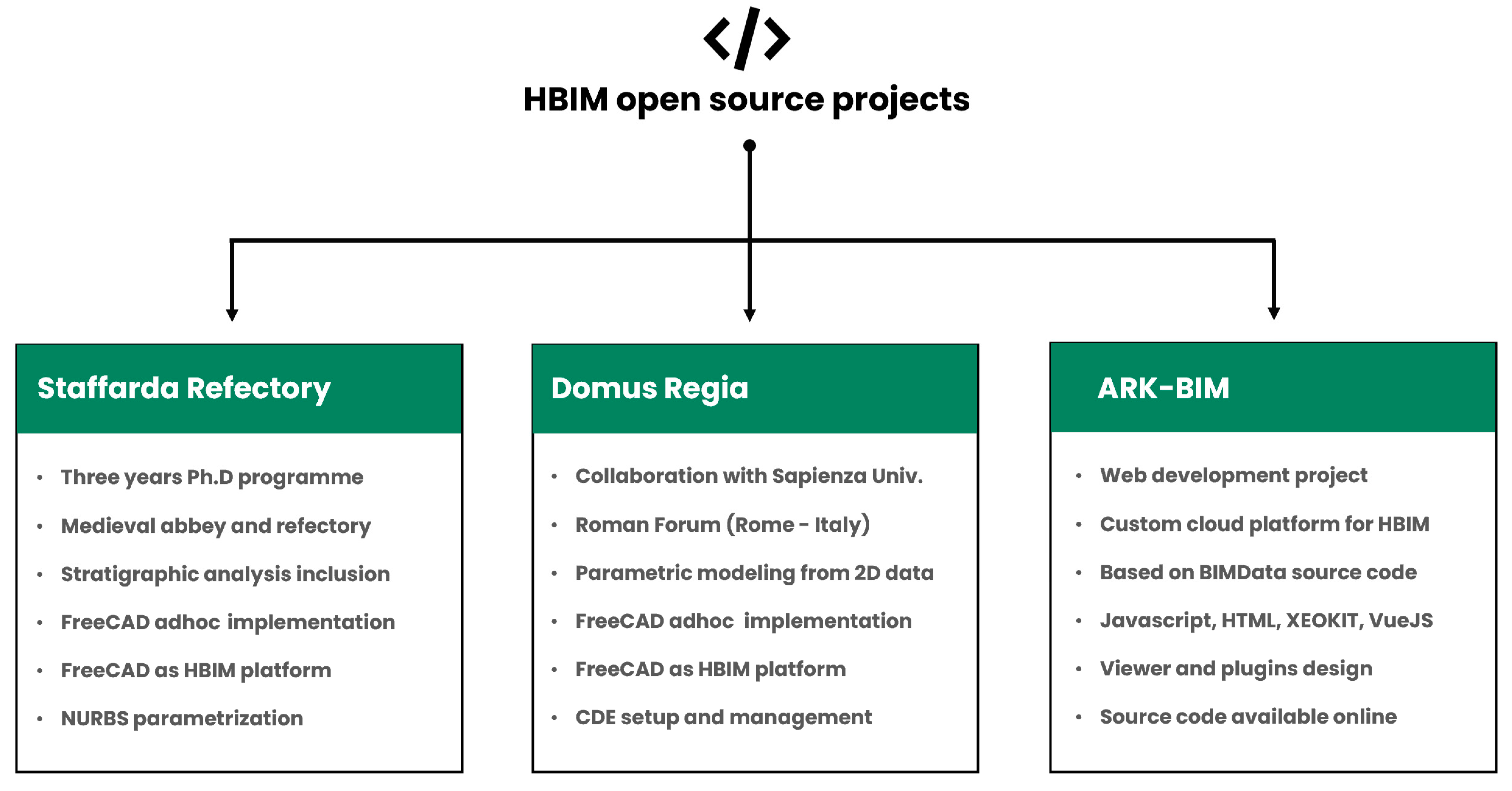
The actual panorama related to the HBIM open source is composed of three main types of research and projects (related to historic/archaeological buildings and platform development): the Staffarda refectory (CN, Italy); the Domus Regia inside the Roman Forum (Rome, Italy); the ARK-BIM project (Figure 1). Additionally, there is another ongoing project focusing on the HBIM documentation of another important building inside the Roman Forum in Rome, the Giacomo Boni Museum (the first museum/Wunderkammer of the Roman Forum remains). This project will be described in future papers.
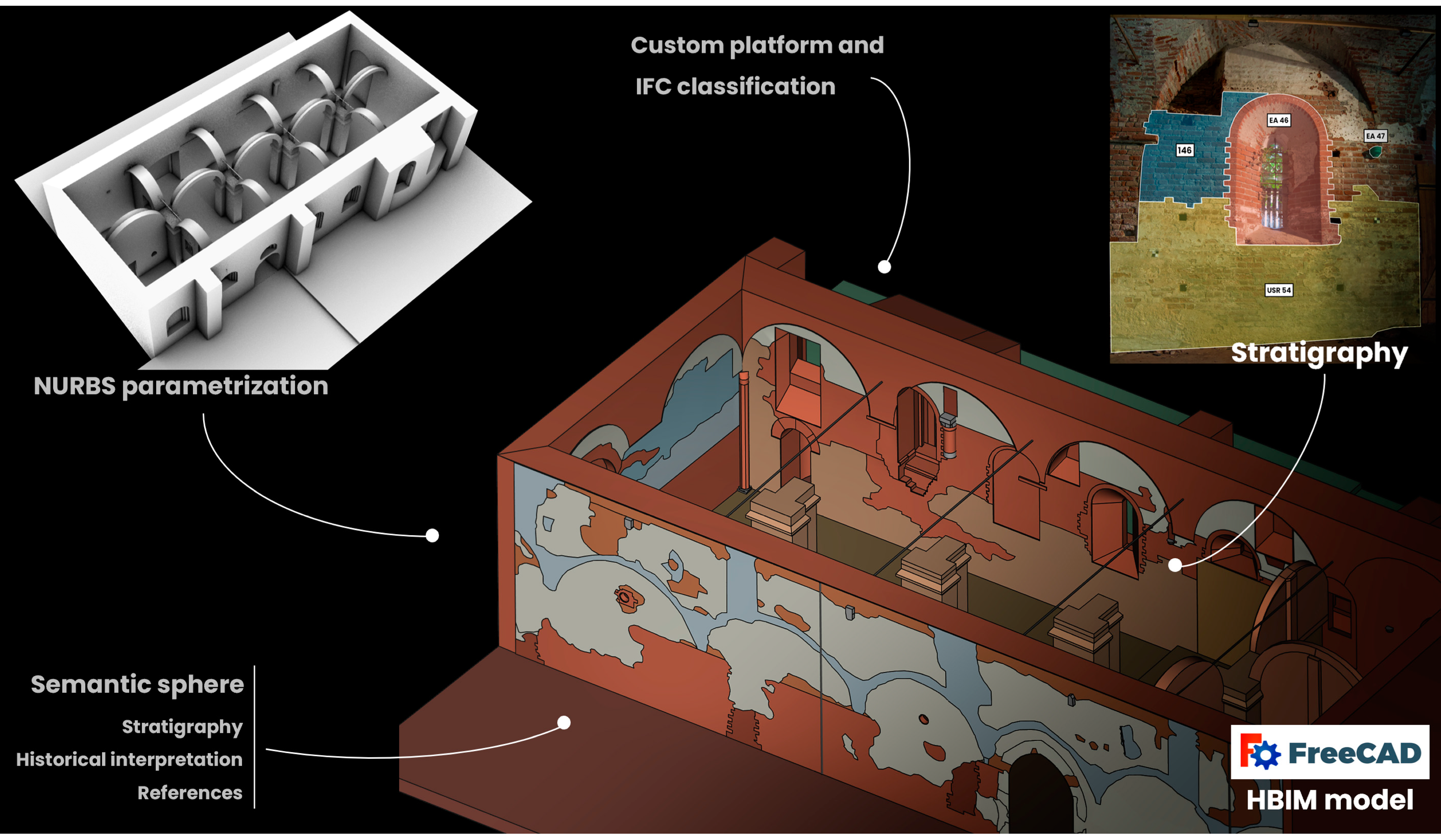
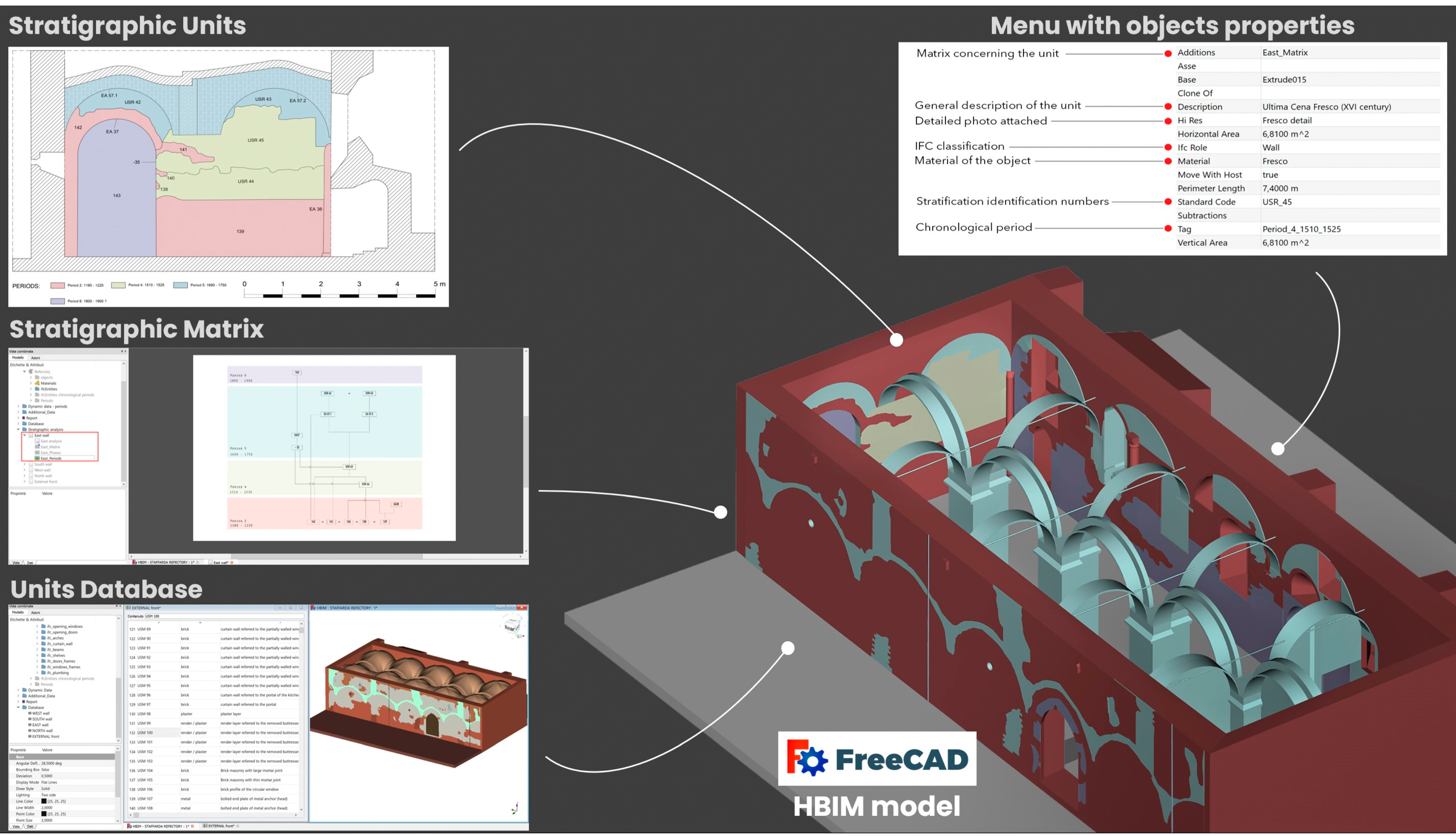
The first project (a PhD programme 2016–2020) is related to the integration of metric and stratigraphic information inside a custom HBIM platform [8,9]. The refectory of the medieval Staffarda Abbey (CN, Italy) was analysed by the following different surveys: metric acquisitions via total station, TLS and photogrammetric approach; stratigraphic survey concerning walls and masonries. In fact, the goal was twofold: the comprehension of the evolution of the refectory aided by the stratigraphic analysis and the HBIM documentation of the refectory and its stratigraphy. The HBIM design was carried out by using FreeCAD open source software. The platform was customised in its libraries, packages and plugins for adapting it to the project framework. The modelling phase was performed via the NURBS (Non-Uniform Rational Basis Spline) methodology inside the Rhinoceros environment. Then, obtained surfaces were parametrised inside FreeCAD by using ad hoc plugins and instruments. The HBIM platform resulted tailor made for the inclusion of historical information in appropriate smart containers (Figure 2). Then, specific queries via SQL language were made. In this way, 3D and semantic data of the refectory were managed inside the HBIM platform for ensuring reviews and updating studies.
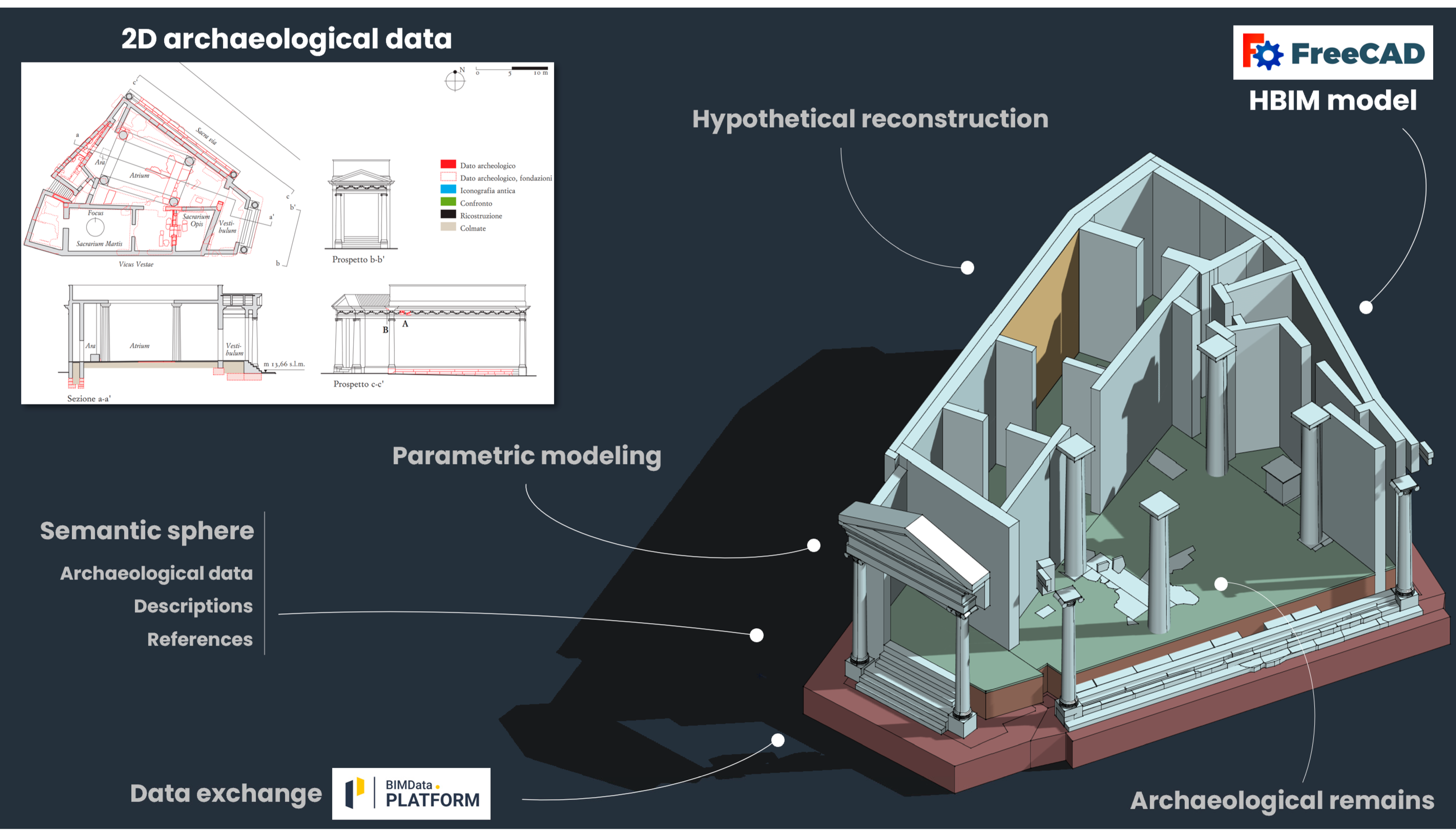
The second project (2021) is related to the HBIM documentation of an archaeological site and its hypothetical reconstruction: the Domus Regia (Sacraria Martis et Opis) situated inside the Roman Forum (Rome, Italy). Adding to important HBIM projects on archaeological architecture in Rome [12], this work was born as a collaboration between the Polytechnic of Turin (Department of Architecture and Design) and Sapienza University of Rome (Archaeology Department) [13]. The main goal of this project was to take advantage of HBIM open source solutions for enhanced archaeological data. In fact, starting from 2D vectorial data extrapolated from the Digital Atlas of Rome, the HBIM design (via FreeCAD) of the Domus Regia started from the parametric modelling of the archaeological situation and the hypothetical model. Then, archaeological information has been included for performing semantic queries. Finally, a common data environment (CDE) has been established by using open source cloud applications (BIMData) for ensuring collaborations and revisions.
The last project is not focused on a particular historical building but on a development of a cloud-based HBIM platform. This open source CDE, named ARK-BIM, was developed and designed for including semantic information of archaeology and heritage assets [14,15]. ARK-BIM allows to upload and also edit in real-time IFC models, permits to analyse resources, images and databases related to the model and also allows to perform graphical and interactive queries. Moreover, ARK-BIM allows to conduct deep reviews of the model through the BIM Collaboration Format (BCF) option.
These are the consolidated projects on the open source HBIM panorama. However, other programmes are still in progress and will be later analysed in other venues. The here-mentioned projects will be thoroughly reported in the following chapters regarding different aspects of the HBIM design from the creation and management to the online/cloud CDE.
2. HBIM Open Source: Creation and Management
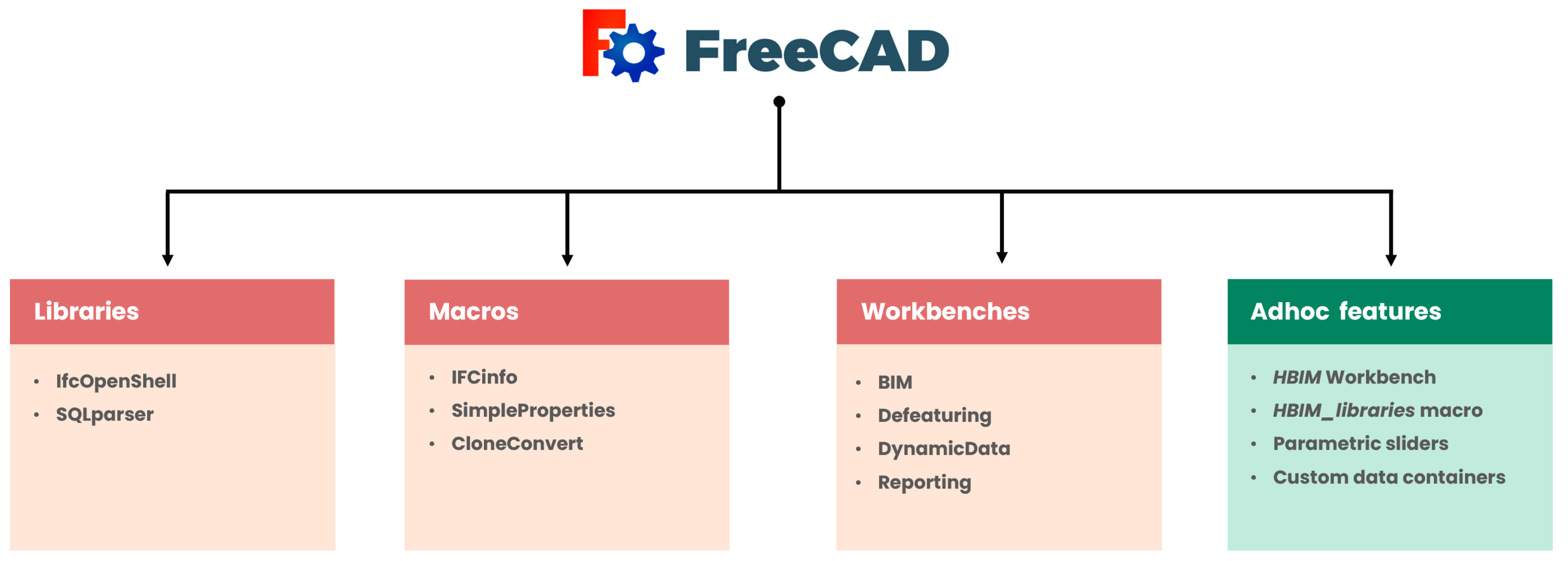
The HBIM design for historical buildings can be summarised in these macro steps: knowledge processes (historical studies as well as metric surveys), parametric modelling and data entry and management. Ending the design phase, main users and collaborators should be able to access, read, edit and query the entire data enclosed inside the platform. However, the utilisation of open source solutions requires an earliest phase for the platform compiling and customising. In this regard, FreeCAD proved to be a reliable software for designing and managing BIM and HBIM projects [8]. Nowadays, it can be considered the only open source software that enables parametric modelling with IFC compatibility and semantic data inclusion.
2.1. HBIM Platform Design
FreeCAD software [11] has been initially developed as a CAD and parametric modeller. Over the years, supported by a large community of users and developers, it has been increasingly enriched with new features and tools related to architecture, construction and engineering. Nevertheless, its growth and implementation continue also aided by an incredible number of additional macros and workbenches (WBs) that can be easily installed depending on specific needs. By installing few workbenches and libraries, FreeCAD can be definitely turned into a complete BIM platform (Figure 3). IfcOpenShell and BIM Workbench offer users, in addition to default workspaces, to easily manage BIM projects and IFC files. IfcOpenShell [16] is an open library that allows managing, importing and exporting the IFC objects, while the BIM workbench allows setting up a project by defining characteristics of the site and the building.
The great potential of FreeCAD concerns its open data and scripts. Apart from being easily included, additional plugins (workbenches and macros) can be modified in their source and structure, allowing users to adapt these tools to specific project stages. In this regard, a plugin such as DynamicData can be implemented for including specific information; it is based on smart containers and menus for managing parametric objects with dynamic properties.
For these reasons, the earlier setup and customisation of the platform is a mandatory step for open source HBIM projects. This phase also helps the tailor-made modelling and semantic data inclusion.
All the default and implementable tools could converge within a new ad hoc workbench designed for built heritage. In this regard, an HBIM WB may include DRAFT, ARCH, PART features as well as additional macros.
2.2. Parametric Modelling from Scratch
The parametric modelling phase concerning BIM projects is based on predefined model libraries designed for AEC. However, these theoretical models should be built through a simplification phase (depending on levels of details), since they are not reality-based representations.
At the same time, the modelling phase and the related simplification of architectural elements of historical buildings should be planned, depending on the project goal as well as the level of information needed (LOIN), which is an ISO standard (ISO 19650) [17,18,19]. For example, the stratigraphic analysis of masonries and decay mapping could be mandatory data for the documentation and the analysis of historical buildings. This kind of information can be classified as LOIN (as fundamental data) and needs to be declared at the beginning of the project. Needed information has to be established by the project collaborators and by those who request the analyses. This decision should follow the purposes of the project. Consequently, the HBIM platform, as well as web solutions, should comply to manage this data and framework. In this regard, another parameter has been introduced for helping and managing the coherence of the project framework, from acquisition phases to parametric modelling: the level of reliability (LOR) [20].
Regarding parametric families, the development of shape libraries for historical buildings is an ongoing goal for different projects, from classical to modern architectural elements [21]. This possibility, within an international collaboration, also concerns the development of custom open source libraries for historic architecture [22].
Exploiting FreeCAD, the creation of parametric libraries is strictly based on DRAFT and PART workbenches, where geometric primitives can be modelled by drafting custom elements or by selecting and modifying default shapes such as cubes, cylinders, torus and cones. This type of modelling is based on OCCT (OpenCASCADE Technology).
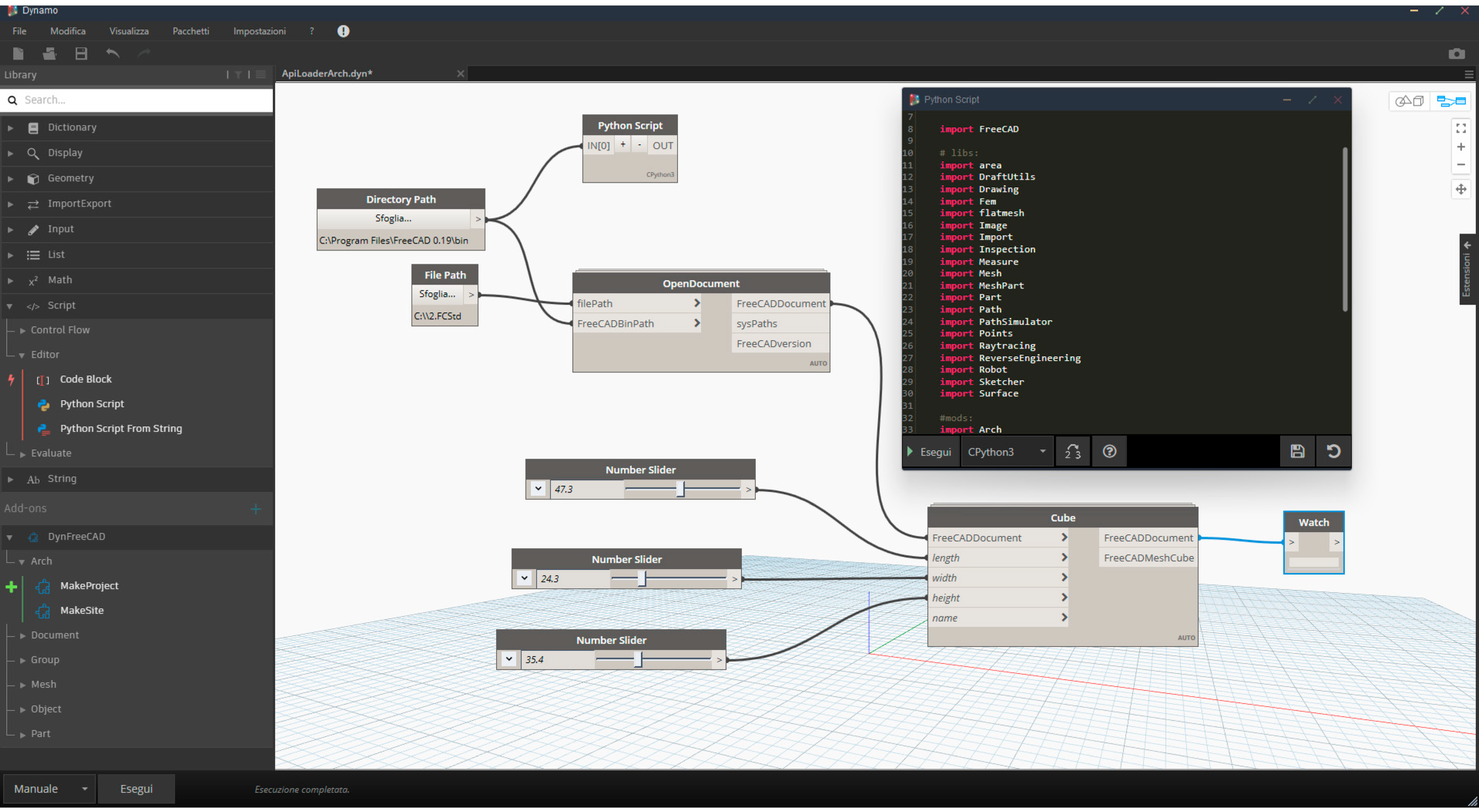
Shapes can be customised and combined (unions, intersections, subtractions) for the purpose of creating ad hoc elements depending on specific needs. Every parametric object can be also implemented and reviewed by using Python scripts or by using dedicated visual programming languages (VPLs). In fact, different development steps on FreeCAD and VPLs have recently started and DynFreeCAD [23] has been composed for integrating the functionalities of Dynamo [24] to FreeCAD software via Python (Figure 4).
At the same time, PyFlow [25] unlocks other VPLs possibilities. It is a visual scripting framework for Python based on dynamic nodes. Being written in the same programming language, this tool is compatible with FreeCAD [26], in particular with the customised version NodeEditor. These latest developments extend and facilitate parametric modelling possibilities for BIM and HBIM by using VPLs and open solutions.
At the same time, custom and simple macros based on dynamic sliders are being developed (via Python) for stretching and modifying metric parameters of parametric objects. For example, elements can be easily edited by sliding a bar concerning heights, lengths, widths, angles, face numbers, etc.
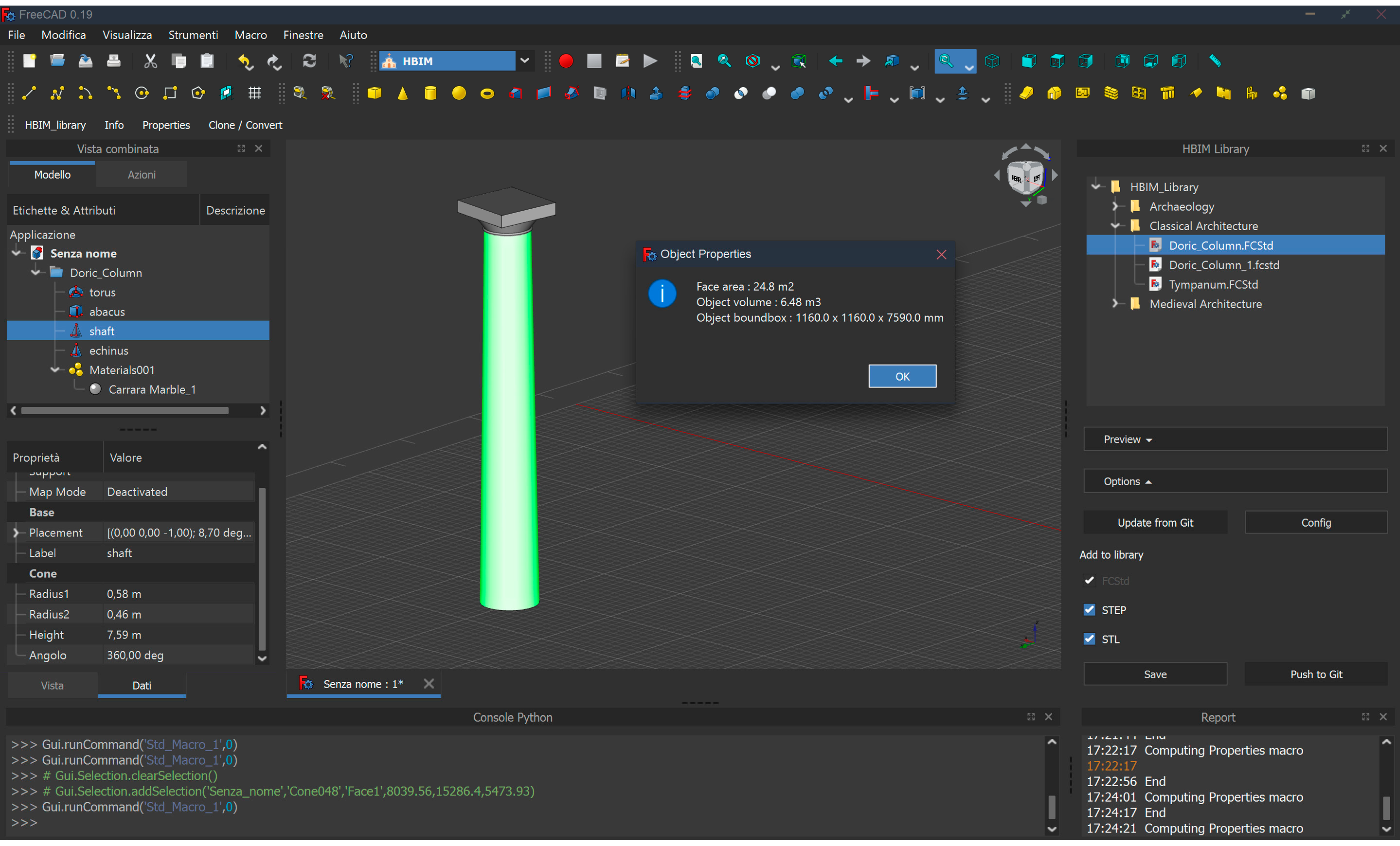
As for shape families, the macro HBIM_library has been included inside FreeCAD (as a smart container) in order to collect custom parametric objects related to heritage assets, modelled under the PART workbench [19]. In this way, architectural models and families can be easily evoked and modified (Figure 5).
Inside the actual open source HBIM panorama, a recent example of parametric modelling from scratch was the Domus Regia project [13]. As mentioned in the introduction chapter, this project focused on the HBIM documentation starting from 2D archaeological data. In fact, vectorial data such as plans, sections and elevations (related to the archaeological situation and the hypothetical reconstruction), were used as basis for the parametric modelling. The instruments of the PART workbench were employed and architectural elements of the Domus Regia were built by using and combining parametric cubes, cylinders, torus and cones. Additions and subtractions were applied during this phase, achieving accurate models, even if simplified in their geometries. Then, customised families were stored. Parametric objects concerning the Roman building were smart repositories for the semantic sphere (excavation data, descriptions, references, stratigraphy, etc.) (Figure 6).
Modelling from scratch (by using PART tools) is not the only possibility for obtaining parametric objects within FreeCAD. Default instruments and additional plugins allow to gain parametric and dynamic models also from surfaces modelled with other techniques.
2.3. Parametric Modelling from NURBS
The most used workflow for creating HBIM models is named scan-to-BIM, from metric surveys (mostly LiDAR scans) to parametric modelling and HBIM setup [27]. Focusing on existing historical buildings, HBIM relies on metric acquisitions and 3D data management. This phase is extremely important. Point cloud management and segmentation allow to obtain profiles of elements that can be used as a basis for the parametric modelling. The latter can be executed by using different strategies such as automatic modelling of simple architectural elements (based on specific algorithms) and modelling architectural elements with a geometry review of the operator. These modelling methods can be done by exploiting specific algorithms and plugins. However, the most reliable solutions for heritage peculiarities are not based on the automatic or semi-automatic extraction of geometries but on a manual comprehension and interpretation of primitive shapes.
Extracted profiles from metric data can be used for understanding and reconstructing geometries. The best way to generate faithful models is to use freeform modelling software. In this regard, NURBS (Non-Uniform Rational Basis Spline) curves and surfaces offer robust and reliable instruments for modelling complex architectural elements.
Why is the NURBS modelling a widespread methodology for the HBIM domain? This kind of representation ensures faithful geometric details for complex architectures. Being not approximated, NURBS curves and surfaces adapt their path and interpolation into a wired profile or directly on point clouds. In this way, high-detailed geometries and buildings can be represented. However, NURBS surfaces are not parametric objects. They need to be processed in order to become smart, dynamic and volumetric ones.
Different HBIM projects are based on the utilisation of NURBS modelling for reconstructing historical buildings before the parametrisation phase [28,29,30]. Then, recent applications are also based on NURBS modelling applied to open source HBIM programmes, generating a particular workflow named scan-to-openBIM via NURBS (creating open source HBIM from metric data and NURBS modelling).
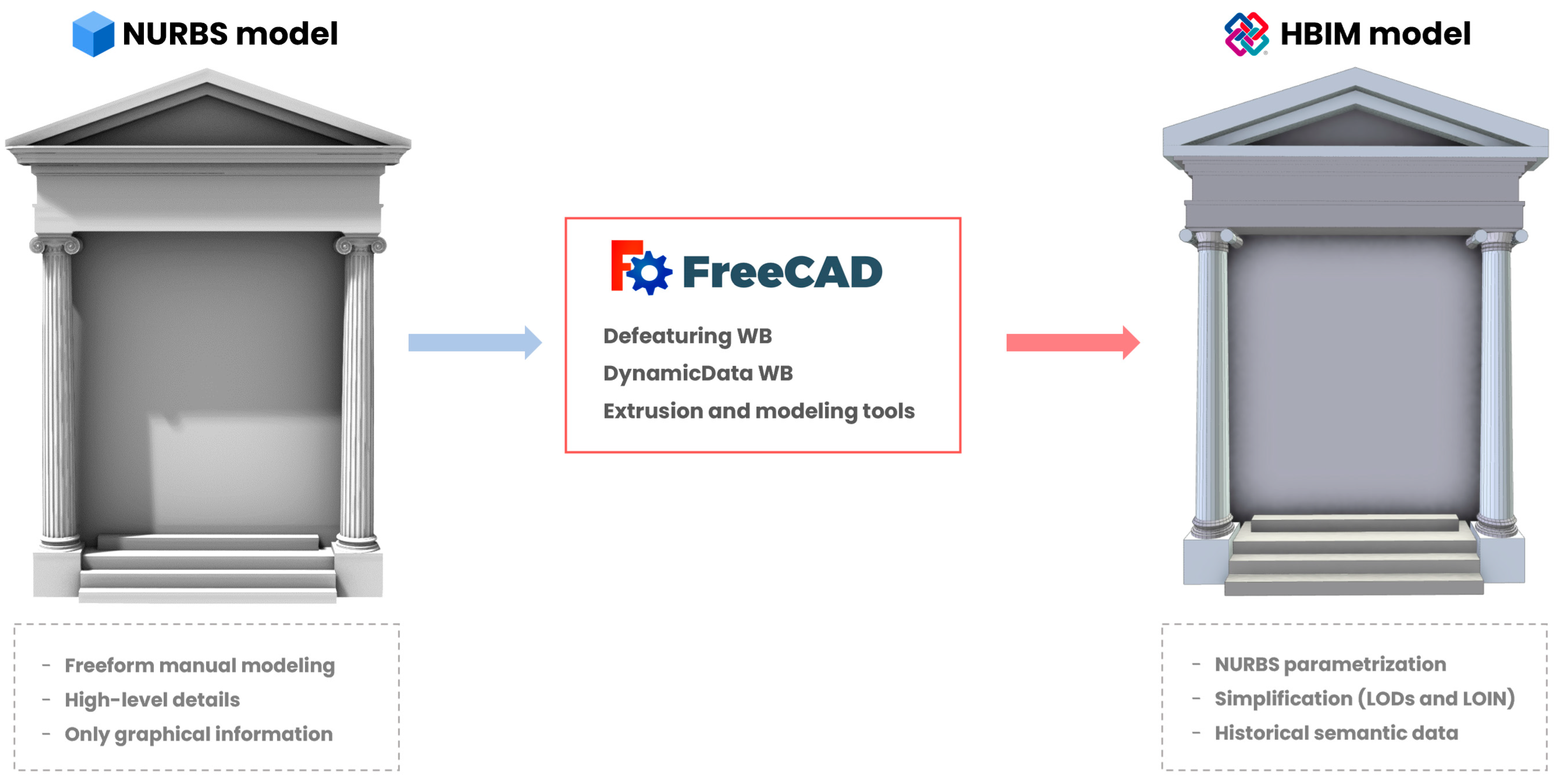
An example of scan-to-openBIM via NURBS was the Staffarda Refectory project [8,9]. As mentioned, the religious medieval building was the centre of a doctoral project (2016–2020) focusing on the analysis of wall stratigraphy via HBIM documentation. The building was surveyed with a total station and terrestrial laser scanner (TLS). Moreover, a photogrammetric acquisition was conducted for the external front of the refectory. Point cloud management revealed fundamental processes, whereby metric data and reality-based models were sectioned on X, Y and Z axes in order to extract profiles. These outputs were the basis for the modelling phase. In fact, inside the Rhinoceros software [31], NURBS curves and surfaces were interpolated into planar sections and profiles derived from the metric data. In this way, architectural elements and geometries have been understood and manually modelled. The parametrisation phase occurred inside FreeCAD software and, apart from extrusion and other modelling tools, Defeaturing and DynamicData workbenches played fundamental roles in optimising NURBS surfaces and in creating smart containers containing specific metric and semantic data (Figure 7). Despite revealing a time-consuming process, the refectory was correctly parametrised, thus becoming an informative model.
2.4. IFC Informative Models
Once obtained, parametric objects related to desired architectural elements or heritage assets, the conversion into informative elements must begin. In this regard, the semantic attribution and classification have to be included in every element.
FreeCAD and ARCH workbenches include powerful instruments for creating BIM objects from scratch and walls, windows and structural elements can be created depending on the default AEC libraries. However, it allows to associate properties and semantic classification also for custom parametric objects; IFC 2X3 and 4.1 schemas are implemented inside the software. In this way, models built by using PART instruments become informative objects having a custom property menu with semantic data.
The IFC classification, developed by buildingSMART [32,33] and widely adopted in the AEC industry and BIM applications, is regularised by the International Organization for Standardization-ISO [34,35]. The default schemas include a typological classification for modern elements concerning architectural design and technical installation.
Despite the incredible number of compatible built elements, heritage assets do not have a specific IFC classification regarding their typology and features. This issue is strictly linked to the lack of predefined parametric families of historical buildings. This is an ongoing issue and a research goal, especially for helping conservation processes based on HBIM methodology [36,37]. The creation of custom parametric families associated with standard IFC classification is the better way to overcome the problem for HBIM purposes.
Nevertheless, custom IFC classification can be designed within the FreeCAD environment. Open codes of the platform allow also to access the IFC 2X3 and 4.1 schemas. In fact, by acting on the accessible source of internal libraries, “ifcTypes” can be modified and extended. In this regard, a custom modification and a proposal schema were proposed in a previous work [38], where specific classifications of heritage assets were implemented inside FreeCAD, including new entities concerning ad hoc parametric families. Architectural elements such as “arch”, “capital”, “column”, “vault”, “single-lancet window” and others were created as sub-types of standard types such as “wall”, “roof”, “window”, etc., inheriting main structural attributes.
Although this modification could be a proper solution for historical architectural elements, it shows limitations and issues. In fact, the proposed classification works only within the FreeCAD environment, because other BIM software and management software do not recognise the occurred implementations, since they strictly rely on ISO standards. However, FreeCAD is able to associate the demonstrative and proposed IFC classification to custom parametric families. In addition, new implementations can be investigated through semantic SQL-based queries and they are fully compatible with other source code modifications occurring within the software.
2.5. Smart Repositories for Semantic Information
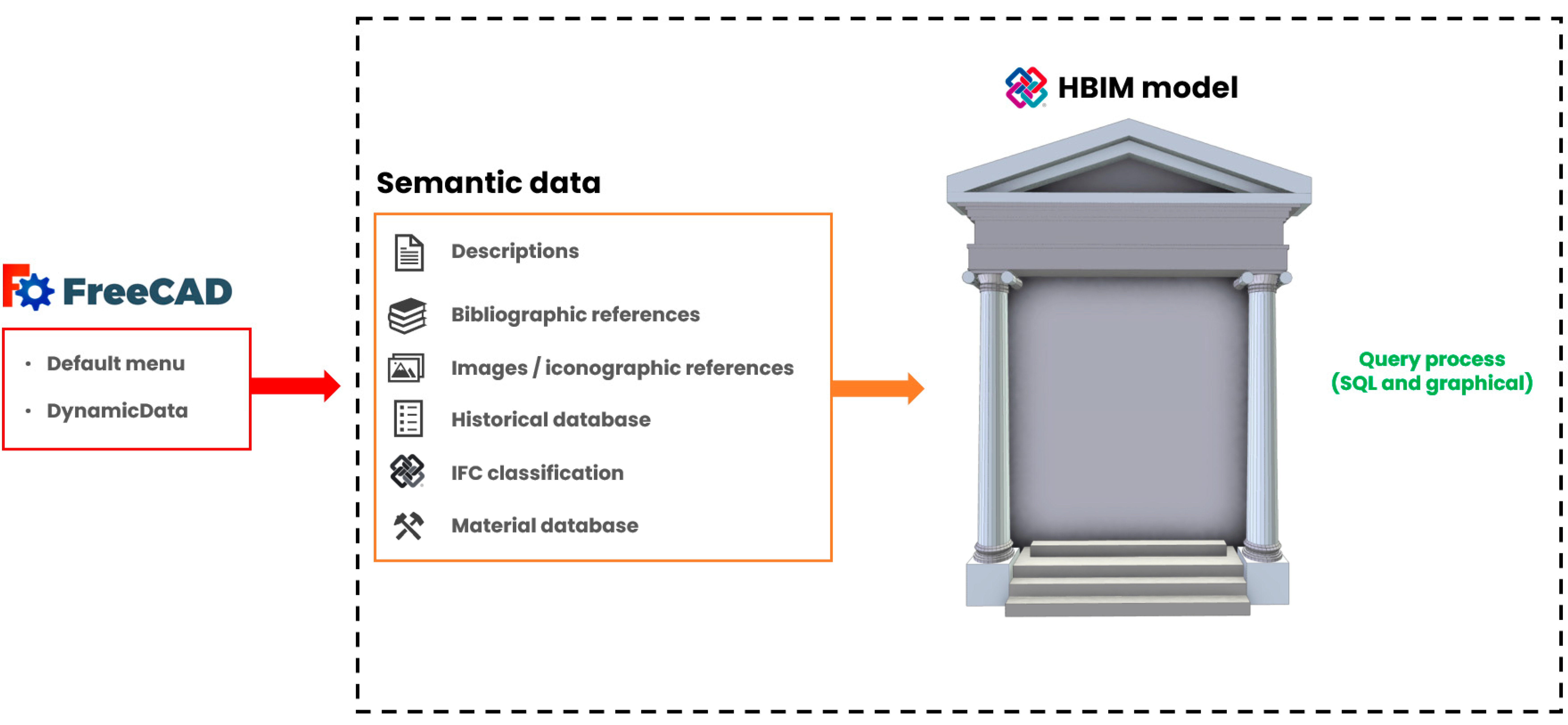
Designing the inclusion of semantic information of historic architecture is a mandatory step for reaching the desired LOIN of projects. Inside the HBIM platform, this phase has to be accurately planned for collecting and ensuring data documentation and exchange (Figure 8).
Parametric models associated with IFC entities become informative objects. FreeCAD shows an informative menu related to object attributes that have a dynamic structure and it changes depending on the IFC typology. In fact, semantic information can be included via text fields and by selecting options inside specific menus. Text attributes are related to descriptions, tags and standard codes fields and selectable attributes concern the material database and IFC classification.
As seen before, the IFC-type menu can be extended by modifying the dedicated source code (with limitations). The material database can be extended via the dedicated editor, implementing materials and attributes concerning specific historical architecture. This is fundamental, since the default database is designed for the AEC industry.
Text fields can be filled with general descriptions or with ID tags and alpha-numerical codes. This possibility is flexible, and different semantic information can be included. Furthermore, custom strings and menus can be created using the DynamicData WB. In this way, textual historical information or additional metric data enhance the actual semantic sphere.
Regarding the refectory of the Staffarda Abbey [8,9], exclusive and unique semantic data were included inside the HBIM model, the wall stratigraphy based on the archaeological method. In addition to metric acquisitions, another knowledge survey—the stratigraphic survey—was performed in order to collect and analyse the complex stratigraphy of the refectory (due to morphological modification over the years). The analysed stratigraphy unlocked the historical comprehension of the construction phases related to the religious building. These data were included in different ways: as parametric objects; as descriptive and textual fields; as reference images and boards. Within FreeCAD, the combination of default (menu and attributes) and implemented features (DynamicData and custom repositories) have allowed the inclusion of this important historical information that rarely can be found inside archives (Figure 9).
Moreover, FreeCAD allows linking images and CSV database to parametric objects, whereby pictures improve the immersion between 3D parametric objects and 2D high-detailed references. At the same time, datasheets increase the information level, allowing to collect and review different types of data (exportable and manageable).
In this way, the HBIM platform turns into a safe environment for document collections and all historical data of architecture or archaeological sites. However, these data need to be managed and investigated for the purpose of performing analyses and further studies. The attributes and properties have to be examined through dynamic queries set by users. In this regard, the implementation of SQL query language within FreeCAD reveals fundamental strategies. The open source language can be incorporated following two methods: the library SQLPARSER and the Reporting WB. The former allows to evocate the SQL language within the Python console and then perform queries. The latter permits to set SQL statements into a configuration box (input) and then the WB generates a datasheet report as output. Query processes on IFC models, which can be conducted through different strategies [39,40], are fundamental for investigating results and better improving the semantic sphere.
Data collection and management that are only performed inside the HBIM platform may not be enough regarding collaborations via multidisciplinary approaches. Data publication and cloud sharing are fundamental for ensuring information exchange among stakeholders. This phase can be designed by operating with cloud-based and web platforms.
3. Open Source Cloud-Based HBIM
3.1. CDEs and Web Developing
The open source HBIM developing framework is not limited only to software (computer programs) but is also available in web applications.
Web and cloud-based solutions experienced an incredible growth because they ensure high-level documentation, collaboration, communication and data accessibility. Furthermore, they permit real-time data access and control. These solutions are dynamic CDEs designed for a multidisciplinary approach inside BIM programmes.
Exactly like BIM software, actual cloud-based services are strictly designed for the AEC industry and many of these solutions are developed to better integrate themselves into main computer programs. In fact, Autodesk BIM 360 [41] is perfectly integrated with Autodesk Revit [42] and together they constitute the most popular and stable suite for BIM and AEC purposes. Many of these web applications are classified as Software-as-a-Service (SaaS) and can be distributed, making accessible the source free of charge via subscriptions. For example, an interesting free solution is BIMserver.center [43], which is a multi-platform service designed for exchanging and managing BIM projects, also allowing the visualisation through VR (Virtual Reality) and AR (Augmented Reality). In addition, an accessible and customisable platform is BIMServer [44], developed and distributed via open source languages.
CDEs rely essentially on a cloud/upload system (or cloud synchronisation) of IFC files and a dynamic database concerning elements attributes, where models can be visualised in a 3D viewer and information can be explored mainly through the dependencies tree. Being online 3D platforms, they are based on specific programming languages and libraries. In fact, web applications focusing on BIM are increasing exponentially thanks to graphic libraries such as WebGL [45]. It is based on Open Graphic Language (OpenGL) [46] and HTML5 for programming 3D web graphics. Different sub-libraries rely on WebGL The most popular for web 3D design are Three.js and SceneJS [47,48].
Moreover, the JavaScript library revealed important facts. In fact, a new library based on JavaScript and also on Three.js, has been recently developed: IFC.js [49]. This open source instrument allows to create IFC viewers for uploading and managing IFC models inside browsers. Through its codes, users can create ad hoc and dynamic web applications based on the 3D scene for visualising and managing BIM models, including linked properties.
Furthermore, other toolkits based on WebGL have been introduced years ago. In fact, XEOLABS [50] developers released the XEOKIT [51] open source toolkit, designed for online BIM management. This powerful instrument opened the floor to the development of the BIMData web platform, an incredible and flexible solution for the online data exchange and collaboration for BIM projects.
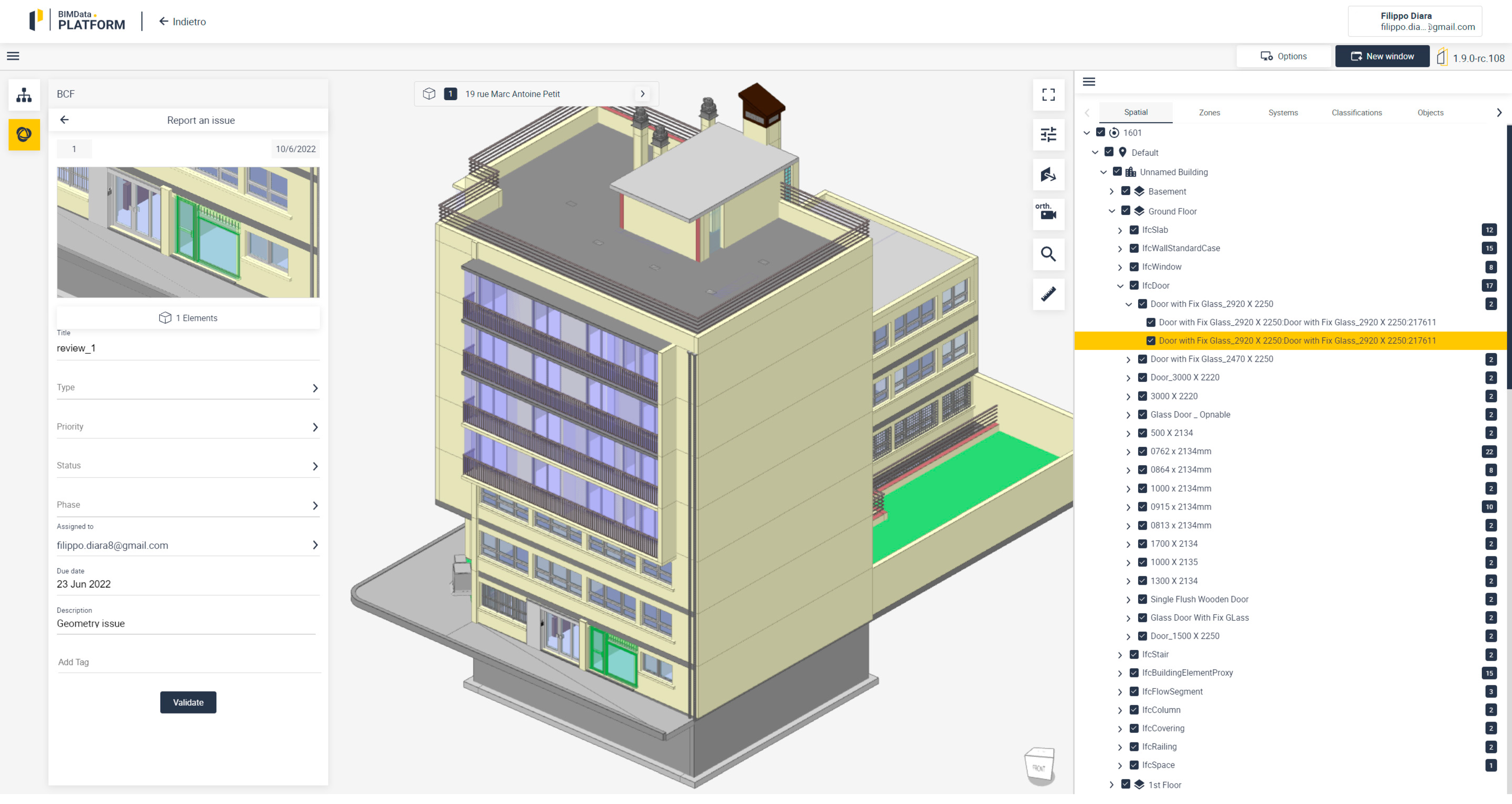
BIMData [52] is a cloud-based BIM application thought for professional collaborations within a complete and stable web platform (Figure 10). The great strength of BIMData concerns its developers and its team. In fact, the environment is constantly updated and new features and improvements are constantly released. Although it is distributed in a three-way format (free professional on request), its source code is accessible to users. The main differences are related to free and professional suites. The former is limited to 300MB of storage (for each workspace), while the second has 10GB. The latter has the splitting and merging function for IFC models, the email support and the IFC editor.
Behind the 3D space and the object trees with properties, the platform ensures deep investigations through different default plugins. The most important is the BIM Collaboration Format (BCF) plugin, this allows revisions on IFC models and linked data. This feature, also included within others platform, is fundamental for multidisciplinary approaches regarding reviews and analyses [53]. The BIMData platform can be easily shared with collaborators via invitations and permissions (guest, user, admin). Moreover, external files such as PDF, DXF and DWG can be uploaded for enriching the documentation of the project.
BIMData also becomes useful for HBIM models, permitting the inclusion of different information and properties. All the described features are important for the documentation and data exchange of historic architectures. Furthermore, HBIM projects can be shared and disseminated with specific stakeholders by using the dynamic space of BIMData.
Like a cascade, the accessible source of the BIMData platform and its important features opened the floor to another developing process.
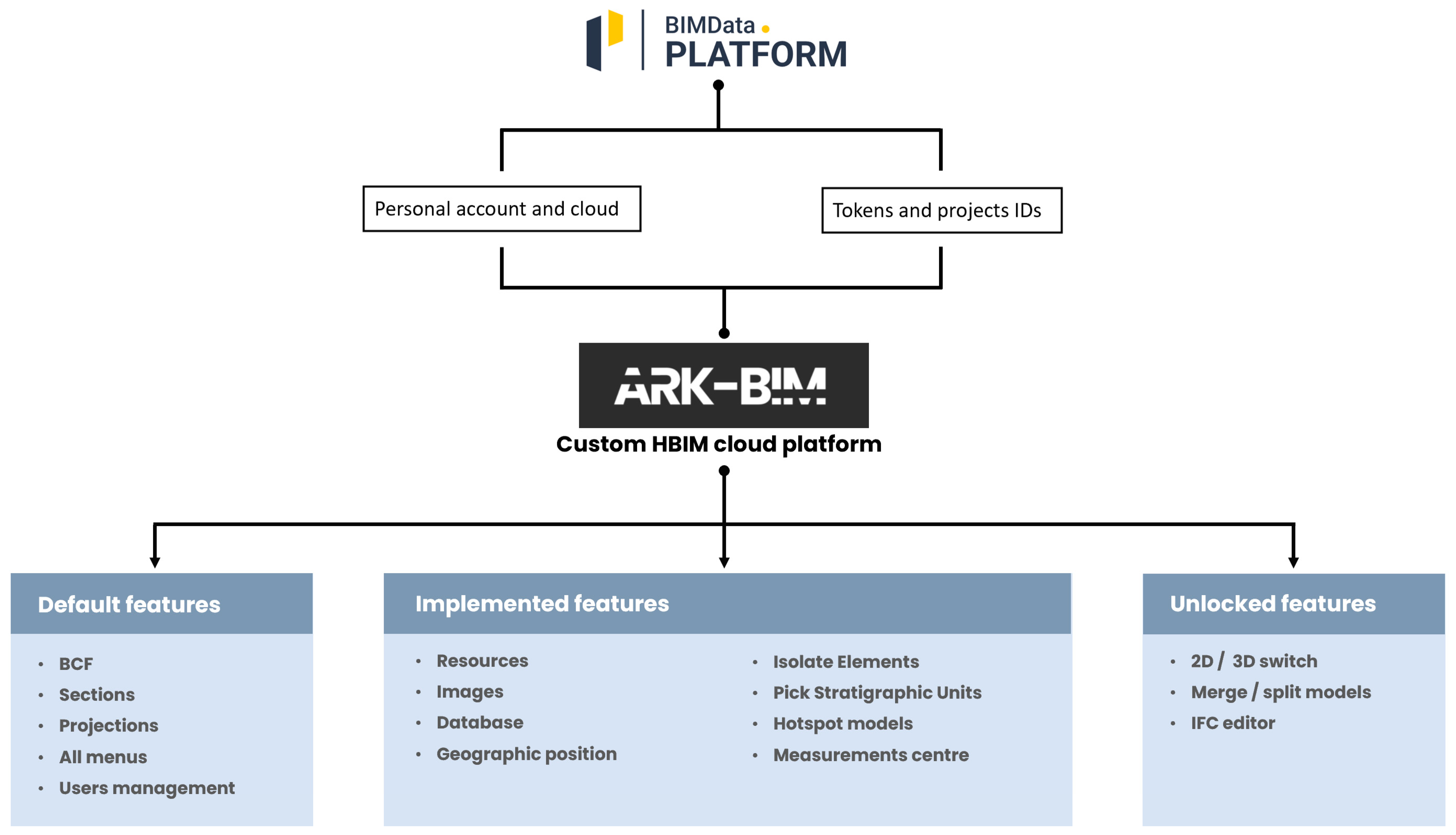
3.2. ARK-BIM Developing
The last three years of web development processes for BIM and AEC unlocked incredible possibilities. Since BIMData developers spread out source codes of the viewer engine, interface and plugins, the creation of personal IFC online platforms was possible. For this reason, a developing phase concerning a custom cloud platform based on BIMData codes started at the end of 2020. The main idea was to create a CDE for heritage assets and archaeological domains that was able to include semantic historical data and allowing reviews and collaborations.
The developed environment, ARK-BIM [14], was thought as a dynamic and modular platform characterised by custom tailored viewer and plugins. Based on different programming languages and toolkits XEOKIT, JavaScript, VueJS, HTML, CSS-ARK-BIM still does not have a cloud structure and it leans on the BIMData upload and synchronisation system (via the BIMData account and specific tokens). The developing phase was twofold: the former concerns the viewer (engine and interface), the latter the plugin designs [14,15].
ARK-BIM functionalities were thought by following the professional version of BIMData. In fact, by acquiring the version 0.8.26 of the viewer, important features were included within the new CDE. In addition to all the default plugins of BIMData (BCF, section plugins, selection and projection options), ARK-BIM also includes the IFC editor (for editing properties in real time), the model split/merge option (for dividing and combining 3D objects), the 2D–3D switch button (Figure 11) and minor modifications concern general fixes, improvements and the interface graphical design.
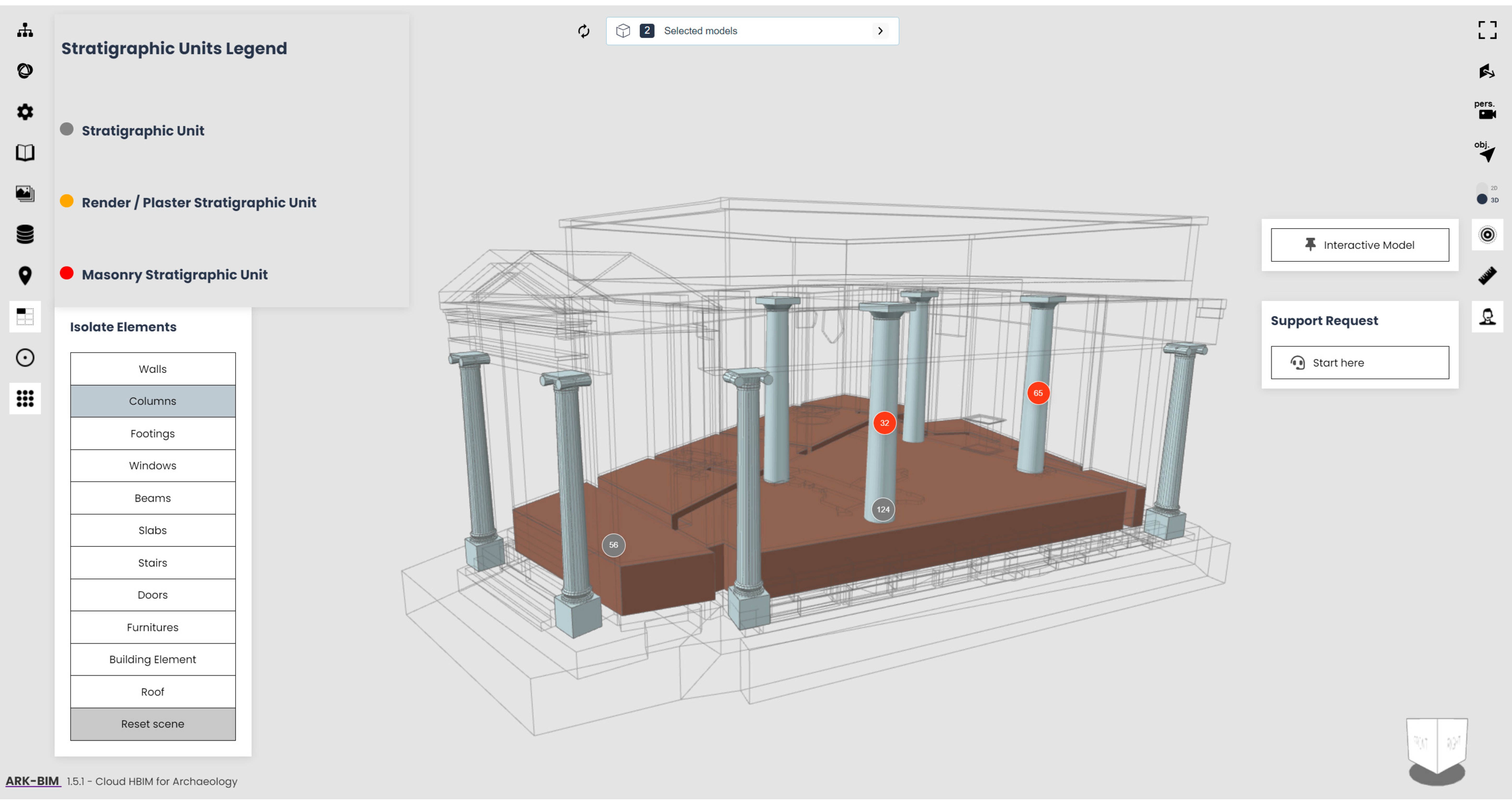
The second developing step is related to the ad hoc plugins designed for heritage assets and archaeology, which are mostly related to data collection, analysis and interactive environments [15].
In addition to settings and geographic position plugins, the semantic data online collection was ensured thanks to plugins such as Resources (for including textual descriptions and bibliographic references), Images (for storing images and iconographic references of the context), and Database (for collecting and investigating specific information inside datasheets). Furthermore, other features for graphical queries and analyses were included. The Isolate Elements plugin was introduced for isolating parametric objects depending on IFC classification, thereby obtaining an immersive graphical investigation. A particular plugin was designed for annotating and analysing the stratigraphy of archaeological sites. In fact, the Pick Stratigraphic Units plugin allows to mark out the units composing the stratigraphy, depending on the US typology and numeration (Figure 12). Lately, two interactive environments were implemented for having hotspot models with informative points (Hotspot Model plugin) and for performing metric analyses on models (Measurements Centre plugin).
At the end of the development processes, ARK-BIM was published, and its source codes were distributed within the website [14] located on GitHub. There, it is free to be utilised and implemented by the community for different purposes and domains. By exploiting web graphic toolkits and codes, a unique online CDE for heritage assets and archaeology was designed. Thanks to the incredible growth of web development concerning BIM, other online platforms for the cultural heritage domain could be born.
4. Discussion and Future Perspectives
HBIM projects performed by using open source solutions involve data accessibility and replicability of the entire design path, providing the community clear and open programmes.
As we have seen, all the HBIM design phases can be performed exclusively with open source solutions from the platform compiling and implementations to the parametric modelling and from the semantic data inclusion via ad hoc instruments to the data exchange and publication via cloud-based applications (Figure 13). The project born around the refectory of Staffarda Abbey revealed fundamental functions for testing and experimenting for the first time with FreeCAD as open source software for BIM.
FreeCAD software proved to be a reliable parametric modeller as well as a smart container for historical data. Its default modelling tools (DRAFT and PART workbenches) and the implemented plugin allow creating BIM models both from scratch and from NURBS surfaces. Then, parametric families can be easily stored and managed for future reviews and projects. Additional features such as DynamicData and Reporting are essential tools for collecting and querying information in a personal way, avoiding limitations of closed software. FreeCAD, with appropriate modifications, could become the main instrument for designing open source HBIM projects. Moreover, HBIM models created within FreeCAD, having an IFC format, can be easily exported and managed outside the open source software. In fact, 3D IFC models can be handled on different BIM software (Revit/ArchiCAD) as well as on CDEs. In this way, projects are not closely related to specific environments and results are sharable among collaborators.
The Domus Regia project proved to be interesting research, filing for integrating 2D archaeological data into a FOSS HBIM environment. The publication and the data-exchange phase occurred in CDE solutions (BIMData and ARK-BIM).
Future perspectives on HBIM open source are certainly linked to the web developing possibilities and CDEs. Previous development progresses in web graphic languages and libraries opened the floor to new ways of designing custom solutions for smart online management. One of the main interesting aspects of this scenario is related to hardware specifications. In fact, cloud and web solutions do not require expensive equipment, merely a web browser and a low/medium graphic card. This is fundamental to guarantee data accessibility to all users.
A future project based on open source HBIM will be the documentation and analysis of the Giacomo Boni Museum on the Roman Forum (Rome, Italy). This work, in collaboration with Parco Archeologico del Colosseo, will be based on a platform design for the semantic information and a data-exchange phase through BIMData and ARK-BIM. In this regard, a parallel ongoing project is based on a new version of the ARK-BIM web platform. In fact, the structure of a new environment freed from the BIMData cloud is now under development.
Other next perspectives are related to the custom tailored plugin and third-party tools implemented within FreeCAD. Being supported by a large-scale community, FreeCAD is constantly updated and improved and plugins, libraries and VPLs increase modelling and BIM/HBIM possibilities. At the same time, it could become a unique platform for scan-to-BIM projects. In fact, recently, the Trails WB (which includes the Geomatics WB) allows importing survey data (topographic points and point clouds) and managing them for creating sections, surfaces and other.
The utilisation of open source software shows clear advantages for HBIM projects. First of all, FOSS instruments allow setting a proper platform for collecting and managing historical data. In this way, a smart and customised informative environment avoids data fragmentation. Accessible source codes allow adapting instruments to specific projects, also trying to overcome the limitations of traditional BIM frameworks.
Despite the mentioned advantages, there are also critical points on the utilisation of open source solutions for HBIM. In fact, the ability to understand and manage FOSS packages, libraries and scripts could limit the general experience of the project workflow. In this regard, the entire design process could be an extremely time-consuming operation, from the software implementation to the ad hoc modifications and from the creation of custom parametric libraries to the CDE settings.
5. Conclusions
Studies carried out through open data have experienced a great development in the cultural heritage panorama, especially in answering accessibility and methodology related issues. Although BIM has become a standard (ISO) and mandatory solution for new constructions and technical installations, the main used BIM software are commercial and closed, even if the IFC format for BIM models is an open format.
The utilisation and adaptation of open source software to HBIM projects has been widely demonstrated through the customisation of FreeCAD software. Since historical buildings have unique peculiarities, the modelling phase has to be conducted creating ad hoc parametric families. Actual BIM software (Autodesk Revit, Graphisoft ArchiCAD) enable this possibility, even though they are not exclusively designed for heritage assets. Unconventional complex buildings or archaeological sites require specific data processing and management and historical semantic data are exclusive information that need to be collected and stored in appropriate ways.
HBIM models should be Digital Informative Twins of historic buildings. Although the geometric representation is intended to be conceptual and simplified (depending on the level of details), HBIM is identified with a 3D dynamic database containing semantic information. The correct way to classify an HBIM model as a Digital Informative Twin is by making the hosting platform complete and accessible. For this reason, semantic data should be stored and investigated through ad hoc environments without limitations.
The here-mentioned projects (the Refectory of Staffarda and the Domus Regia) showed how FreeCAD can be turned from a simple parametric modeller into an operative and complete informative system based on BIM methodology. At the same time, a custom cloud solution such as ARK-BIM proved to be a reliable suite for heritage assets and the archaeological domain [15].
Free and open source adoption could be the right solution for specific research and projects (for example, where the FOSS utilisation is necessary to adapt instruments to particular needs). At the same time, free and open tools may not always be the perfect solution for designing all BIM and HBIM programmes. As introduced in this manuscript, reasons for using open source solutions should be related to necessity, ethics and advantages.
Funding
This research received no external funding.
Institutional Review Board Statement
Not applicable.
Informed Consent Statement
Not applicable.
Data Availability Statement
The ARK-BIM platform and its source are available and can be download on the official website: https://ark-bim.github.io (accessed on 19 August 2022). Moreover, an example of platform with a HBIM model is available on: https://ark-bim.github.io/version1.5.1-sample/ (accessed on 19 August 2022).
Acknowledgments
All the mentioned projects have been deeply inspired by the guidelines of the International Committee of Architectural Photogrammetry (CIPA), the scientific committee of ICOMOS. These directions concern Cultural Heritage documentation and preservation through the utilisation of open source solutions for correct data dissemination as well as accessibility. Moreover, this work was supported from 2016 to 2020 by the GAMHer project (Geomatics data Acquisition and Management for landscape and built Heritage in a European perspective), a 3-year project financed under the Italian PRIN 2015 framework (Progetti di Ricerca di Rilevante Interesse Nazionale). In this regard, the author would like to acknowledge Fulvio Rinaudo for cooperating and supporting this research on open source HBIM in these years. Furthermore, the author would like to acknowledge Paolo Carafa and Fabio Cavallero for the collaboration phases concerning the Domus Regia project, and Michela Sediari (Parco Archeologico del Colosseo) for creating this important academic network and for the collaboration into the next open source HBIM project: The Giacomo Boni Museum.
Conflicts of Interest
The author declares no conflict of interest.
References
- Murphy, M.; McGovern, E.; Pavia, S. Historic building information modelling (HBIM). Struct. Surv. 2009, 27, 311–327. [Google Scholar] [CrossRef]
- Murphy, M.; McGovern, E.; Pavia, S. Historic Building Information Modelling—Adding intelligence to laser and image based surveys of European classical architecture. ISPRS J. Photogramm. Remote Sens. 2013, 76, 89–102. [Google Scholar] [CrossRef]
- Logothetis, S.; Delinasiou, A.; Stylianidis, E. Building Information Modelling for Cultural Heritage: A review. ISPRS Ann. Photogramm. Remote Sens. Spatial Inf. Sci. 2015, II-5/W3, 177–183. [Google Scholar] [CrossRef]
- Logothetis, S.; Stylianidis, E. BIM Open Source Software (OSS) for the documentation of Cultural Heritage. Virtual Archaeol. Rev. 2016, 7, 28–35. [Google Scholar] [CrossRef]
- Logothetis, S.; Karachaliou, E.; Valari, E.; Stylianidis, E. Open source cloud-based technologies for BIM. In The International Archives of the Photogrammetry, Remote Sensing and Spatial Information Sciences; Copernicus GmbH: Göttingen, Germany, 2018; Volume 42-2, pp. 607–614. [Google Scholar]
- Logothetis, S.; Valari, E.; Karachaliou, E.; Stylianidis, E. Spatial DMBS architecture for a free and open source BIM. In The International Archives of the Photogrammetry, Remote Sensing and Spatial Information Sciences; Copernicus GmbH: Göttingen, Germany, 2017; Volume 42-2/W5, pp. 467–473. [Google Scholar] [CrossRef]
- Diara, F.; Rinaudo, F. Open source HBIM for Cultural Heritage: A project proposal. In The International Archives of the Photogrammetry, Remote Sensing and Spatial Information Sciences; Copernicus GmbH: Göttingen, Germany, 2018; Volume 42, pp. 303–309. [Google Scholar]
- Diara, F. Experimental Workflow for the Creation of a Non-Conventional Open Source HBIM Platform Integrating Metric Data and Stratigraphic Analysis: The Case Study of the Refectory of Santa Maria di Staffarda Abbey. Ph.D. Thesis, DAD Department, Politecnico di Torino, Turin, Italy, 22 April 2020. [Google Scholar]
- Diara, F.; Rinaudo, F. Building archaeology documentation and analysis through open source HBIM solutions via NURBS modelling. In The International Archives of the Photogrammetry, Remote Sensing and Spatial Information Sciences; Copernicus GmbH: Göttingen, Germany, 2020; pp. 1381–1388. [Google Scholar]
- Bianchini, C.; Potestà, G. BIM for built cultural heritage: The case of the Baptistery of San Giovanni in Florence. In Proceedings of the IOP Conference Series: Materials Science and Engineering, International Conference Florence Heri-Tech: The Future of Heritage Science and Technologies, Online, 14–16 October 2020; Volume 949, p. 012044. [Google Scholar] [CrossRef]
- FreeCAD, Parametric Open Source Modeller. Available online: https://www.freecadweb.org/ (accessed on 19 August 2022).
- Attenni, M. Informative Models for Architectural Heritage. Heritage 2019, 2, 2067–2089. [Google Scholar] [CrossRef]
- Diara, F.; Cavallero, F. From excavation data to HBIM environment and cloud sharing: The case study of Domus Regia, Sacraria Martis et Opis (Roman Forum, Rome—Italy). In The International Archives of the Photogrammetry, Remote Sensing and Spatial Information Sciences; Copernicus GmbH: Göttingen, Germany, 2021; Volume 46-M-1-2021, pp. 207–213. [Google Scholar]
- ARK-BIM, A Cloud HBIM Platform for Archaeology. Available online: https://ark-bim.github.io (accessed on 19 August 2022).
- Diara, F.; Rinaudo, F. ARK-BIM: Open-Source Cloud-Based HBIM Platform for Archaeology. Appl. Sci. 2021, 11, 8770. [Google Scholar] [CrossRef]
- IfcOpenShell Library. Available online: http://ifcopenshell.org/ (accessed on 19 August 2022).
- ISO 19650. Available online: https://www.iso.org/standard/68078.html (accessed on 19 August 2022).
- Radanovic, M.; Khoshelham, K.; Fraser, C. Geometric accuracy and semantic richness in heritage BIM: A review. Digit. Appl. Archaeol. Cult. Herit. 2020, 19, e00166. [Google Scholar] [CrossRef]
- Malovrh Rebec, K.; Deanovič, B.; Oostwegel, L. Old buildings need new ideas: Holistic integration of conservation-restoration process data using Heritage Building Information Modelling. J. Cult. Herit. 2022, 55, 30–42. [Google Scholar] [CrossRef]
- Bianchini, C.; Attenni, M.; Potestài, G. Regenerative Design Tools for the Existing City: HBIM Potentials. In Rethinking Sustainability Towards a Regenerative Economy. Future City; Andreucci, M.B., Marvuglia, A., Baltov, M., Hansen, P., Eds.; Springer: Cham, Switzerland, 2021; Volume 15. [Google Scholar] [CrossRef]
- Kontoudaki, A.; Georgopoulos, A. HBIM library development for a doric temple column. Int. Arch. Photogramm. Remote Sens. Spatial Inf. Sci. 2022, 43-B2-2022, 1153–1158. [Google Scholar] [CrossRef]
- Murphy, M.; Meegan, E.; Keenaghan, G.; Chenaux, A.; Corns, A.; Fai, S.; Chow, L.; Zheng, Y.; Dore, C.; Scandurra, S.; et al. Shape grammar libraries of european classical architectural elements for historic BIM. In The International Archives of the Photogrammetry, Remote Sensing and Spatial Information Sciences; Copernicus GmbH: Göttingen, Germany, 2021; Volume 46-M-1, pp. 479–486. [Google Scholar] [CrossRef]
- DynFreeCAD, Dynamo Nodes for FreeCAD. Available online: https://github.com/infeeeee/DynFreeCAD (accessed on 19 August 2022).
- Dynamo, an Open Source Computational Design Platform. Available online: https://www.dynamobim.org (accessed on 19 August 2022).
- PyFlow, a Visual Scripting for Python. Available online: https://github.com/wonderworks-software/PyFlow (accessed on 19 August 2022).
- Senthilvel, M.J.; Beetz, J. A visual programming approach for validating linked building data. In EG-ICE 2020 Proceedings. Workshop on Intelligent Computing in Engineering; Universitätsverlag der TU Berlin: Berlin, Germany, 2020; pp. 403–411. [Google Scholar] [CrossRef]
- Özeren, Ö.; Korumaz, M. Lidar to HBIM for Analysis ofHistorical Buildings, 2021. Adv. LIDAR 2021, 1, 27–31. [Google Scholar]
- Oreni, D.; Brumana, R.; Banfi, F.; Bertola, L.; Barazzetti, L.; Cuca, B.; Previtali, M.; Roncoroni, F. Beyond Crude 3D Models: From Point Clouds to Historical Building Information Modeling via NURBS. Lect. Notes Comput. Sci. 2014, 8740, 166–175. [Google Scholar]
- Diara, F.; Rinaudo, F. From reality to parametric models of Cultural Heritage assets for HBIM. In The International Archives of the Photogrammetry, Remote Sensing and Spatial Information Sciences; Copernicus GmbH: Göttingen, Germany, 2019; Volume 42-2, pp. 413–419. [Google Scholar]
- Croce, V.; Caroti, G.; Piemonte, A.; Bevilacqua, M.G. From survey to semantic representation for cultural heritage: The 3D modelling of recurring architectural elements. Acta IMEKO 2021, 10, 13. [Google Scholar] [CrossRef]
- Rhinoceros. Freeform NURBS Modeller Software. Available online: http://rhino3d.com/ (accessed on 19 August 2022).
- BuildingSmart. Available online: https://www.buildingsmart.org/ (accessed on 19 August 2022).
- BuildingSmart IFC Specifications. Available online: https://technical.buildingsmart.org/standards/ifc/ifc-schema-specifications/ (accessed on 19 August 2022).
- ISO 16739-1; Industry Foundation Classes (IFC) for Data Sharing in the Construction and Facility Management Industries—Part1: Data Schema, ISO16739-1:2018. Available online: https://www.iso.org/standard/70303.html (accessed on 19 August 2022).
- ISO/TC 184/SC 4; Industrial Automation Systems and Integration—Product Data Representation and Exchange—Part 21: Implementation Methods: Clear Text Encoding of the Exchange Structure, ISO10303-21:2016. Available online: https://www.iso.org/standard/63141.html (accessed on 19 August 2022).
- Nieto-Julián, J.E.; Farratell, J.; Bouzas Cavada, M.; Moyano, J. Collaborative Workflow in an HBIM Project for the Restoration and Conservation of Cultural Heritage. Int. J. Archit. Herit. 2022. [Google Scholar] [CrossRef]
- Prizeman, O.; Pezzica, C.; Taher, A.; Boughanmi, M. Networking Historic Environmental Standards to Address Modern Challenges for Sustainable Conservation in HBIM. Appl. Sci. 2020, 10, 1283. [Google Scholar] [CrossRef]
- Diara, F.; Rinaudo, F. IFC Classification for FOSS HBIM: Open Issues and a Schema Proposal for Cultural Heritage Assets. Appl. Sci. 2020, 10, 8320. [Google Scholar] [CrossRef]
- Lee, G.; Jeong, J.; Won, J.; Cho, C.; You, S.J.; Ham, S.; Kang, H. Query performance of the IFC model server using an object-relational database approach and a traditional relational database approach. J. Comput. Civ. Eng. 2014, 28, 210–222. [Google Scholar] [CrossRef]
- Tauscher, E.; Bargstädt, H.J.; Smarsly, K. Generic BIM queries based on the IFC object model using graph theory. In Proceedings of the 16th International Conference on Computing in Civil and Building Engineering, Osaka, Japan, 6–8 July 2016. [Google Scholar]
- Autodesk BIM360, Cloud for BIM. Available online: https://www.autodesk.com/bim-360/ (accessed on 19 August 2022).
- Autodesk Revit, BIM Software. Available online: https://www.autodesk.com/products/revit/ (accessed on 19 August 2022).
- BIMServer.Center. A BIM Server Web App. Available online: https://bimserver.center/en (accessed on 19 August 2022).
- BIMServer, Open-Source Server BIM. Available online: https://github.com/opensourceBIM/BIMserver (accessed on 19 August 2022).
- WebGL, Graphic Library. Available online: https://www.get.webgl.org (accessed on 19 August 2022).
- OpenGL, Open Graphic Library. Available online: https://www.opengl.org (accessed on 19 August 2022).
- Three.js, a JavaScript 3D Library. Available online: https://www.threejs.org (accessed on 19 August 2022).
- Scene.js, a JavaScript Animation Library. Available online: https://www.scene.js.org (accessed on 19 August 2022).
- IFC.js, a JavaScript Library. Available online: https://www.ifcjs.github.io/info (accessed on 19 August 2022).
- XEOLABS, Developing Graphics Software for Web-based BIM, Engineering and Medicine. Available online: https://XEOLABS.com (accessed on 19 August 2022).
- XEOKIT, Open-Source Programming Toolkit. Available online: https://xeokit.io (accessed on 19 August 2022).
- BIMData, An Open-Source BIM Platform. Available online: https://bimdata.io (accessed on 19 August 2022).
- Lima Da Silva, F.B.; Mizrahy Cuperschmid, A.R.; Cerávolo, A.L.; Minto Fabricio, M. A Technological Prospect for a Diagnostic Model in HBIM. J. Comput. Cult. Herit. 2022; accepted. [Google Scholar] [CrossRef]
Figure 1.
HBIM projects designed and developed via open source instruments and programming languages: the Staffarda refectory project, the Domus Regia project and the ARK-BIM development.
Figure 1.
HBIM projects designed and developed via open source instruments and programming languages: the Staffarda refectory project, the Domus Regia project and the ARK-BIM development.

Figure 2.
The Staffarda refectory project: HBIM model designed from reality-based data and NURBS reconstruction. Stratigraphy and other historical information implemented for future analyses.
Figure 2.
The Staffarda refectory project: HBIM model designed from reality-based data and NURBS reconstruction. Stratigraphy and other historical information implemented for future analyses.

Figure 3.
FreeCAD main implementations: from features developed by the community to specific features for HBIM.
Figure 3.
FreeCAD main implementations: from features developed by the community to specific features for HBIM.

Figure 4.
Dynamo and the implementation of DynFreeCAD. The project is currently undergoing development tests and improvements.
Figure 4.
Dynamo and the implementation of DynFreeCAD. The project is currently undergoing development tests and improvements.

Figure 5.
HBIM_Library macro inside FreeCAD for evocating predefined custom parametric models. The column is composed of PART elements such as torus, cubes and cones. The macro is included inside the HBIM workbench.
Figure 5.
HBIM_Library macro inside FreeCAD for evocating predefined custom parametric models. The column is composed of PART elements such as torus, cubes and cones. The macro is included inside the HBIM workbench.

Figure 6.
The Domus Regia project: from 2D archaeological data to HBIM model and data exchange exclusively with open source solutions.
Figure 6.
The Domus Regia project: from 2D archaeological data to HBIM model and data exchange exclusively with open source solutions.

Figure 7.
From NURBS to HBIM model via FreeCAD open source software: default tools and implemented workbenches for converting NURBS into parametric and informative objects.
Figure 7.
From NURBS to HBIM model via FreeCAD open source software: default tools and implemented workbenches for converting NURBS into parametric and informative objects.

Figure 8.
Semantic data inclusion is essential for query processes. Default menu and DynamicData WB allow to enrich the parametric model with technical and historical information.
Figure 8.
Semantic data inclusion is essential for query processes. Default menu and DynamicData WB allow to enrich the parametric model with technical and historical information.

Figure 9.
Stratigraphic units and analysis implemented inside the HBIM model of the refectory: stratigraphy and interpretation as parametric objects, database, semantic data and images.
Figure 9.
Stratigraphic units and analysis implemented inside the HBIM model of the refectory: stratigraphy and interpretation as parametric objects, database, semantic data and images.

Figure 10.
BIMData platform: detail of the sample model inside the 3D viewer. On the right side the properties tree; on the left the BCF plugin for generating reviews.
Figure 10.
BIMData platform: detail of the sample model inside the 3D viewer. On the right side the properties tree; on the left the BCF plugin for generating reviews.

Figure 11.
From the BIMData platform to ARK-BIM development: default, implemented and unlocked features inside the new CDE.
Figure 11.
From the BIMData platform to ARK-BIM development: default, implemented and unlocked features inside the new CDE.

Figure 12.
The Domus Regia HBIM model inside the ARK-BIM environment. Additional plugins are on the left and right side of the window: details on picked stratigraphic units and “IfcColumn” isolated in the 3D environment.
Figure 12.
The Domus Regia HBIM model inside the ARK-BIM environment. Additional plugins are on the left and right side of the window: details on picked stratigraphic units and “IfcColumn” isolated in the 3D environment.

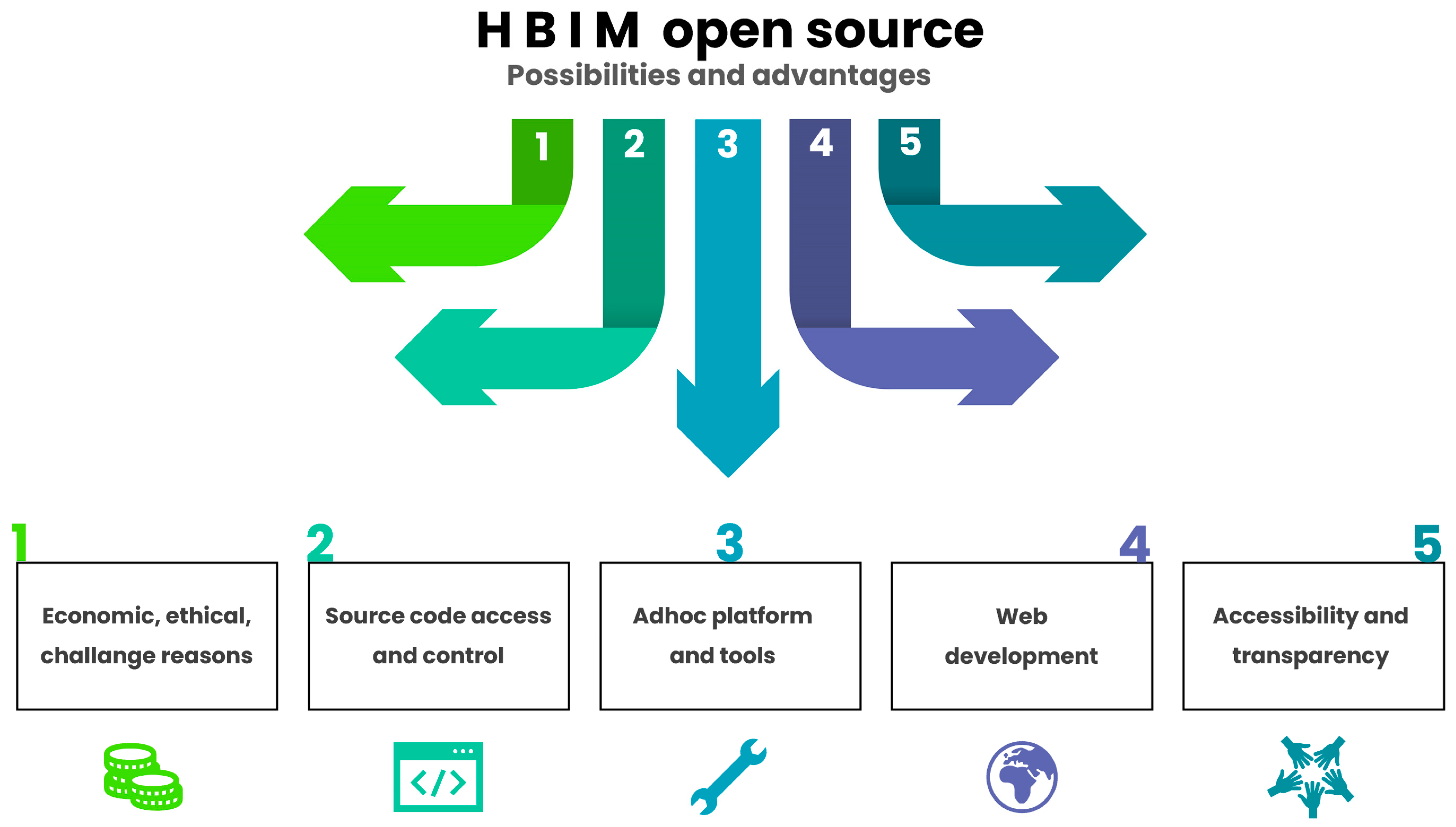
Figure 13.
Possibilities and advantages of using open source solutions applied to HBIM methodology: from initial reasons to final stages of the project.
Figure 13.
Possibilities and advantages of using open source solutions applied to HBIM methodology: from initial reasons to final stages of the project.

Publisher’s Note: MDPI stays neutral with regard to jurisdictional claims in published maps and institutional affiliations. |
© 2022 by the author. Licensee MDPI, Basel, Switzerland. This article is an open access article distributed under the terms and conditions of the Creative Commons Attribution (CC BY) license (https://creativecommons.org/licenses/by/4.0/).
Share and Cite
MDPI and ACS Style
Diara, F. HBIM Open Source: A Review. ISPRS Int. J. Geo-Inf. 2022, 11, 472. https://doi.org/10.3390/ijgi11090472
AMA Style
Diara F. HBIM Open Source: A Review. ISPRS International Journal of Geo-Information. 2022; 11(9):472. https://doi.org/10.3390/ijgi11090472
Chicago/Turabian StyleDiara, Filippo. 2022. "HBIM Open Source: A Review" ISPRS International Journal of Geo-Information 11, no. 9: 472. https://doi.org/10.3390/ijgi11090472
Note that from the first issue of 2016, this journal uses article numbers instead of page numbers. See further details here.