
Leveraging Spatio-Temporal Graphs and Knowledge Graphs: Perspectives in the Field of Maritime Transportation


Abstract
:1. Introduction
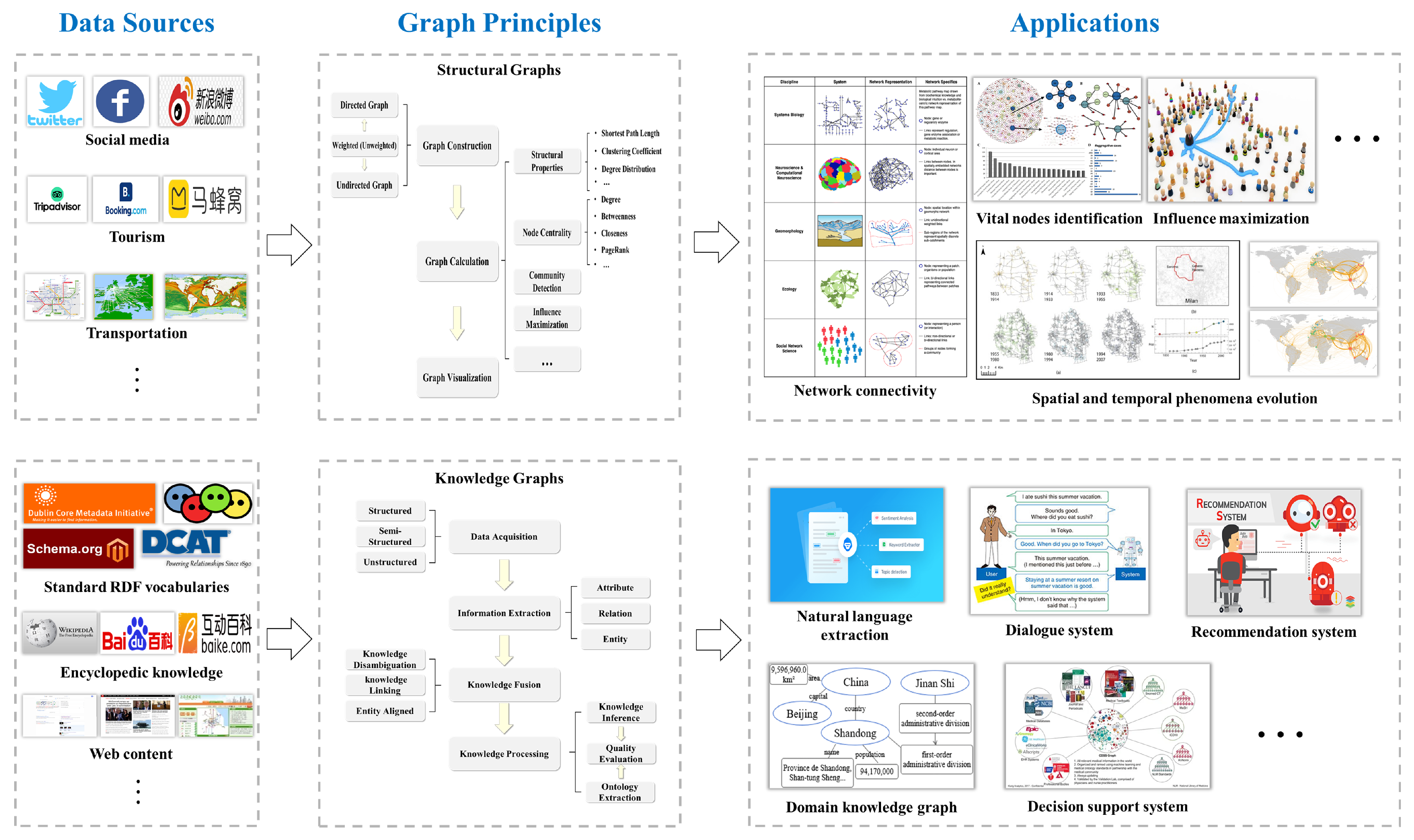
2. Graphs
2.1. Structural Graphs
2.2. Spatial Graphs and Spatio-Temporal Graphs
2.2.1. Spatial Graphs
2.2.2. Granularity in Graphs
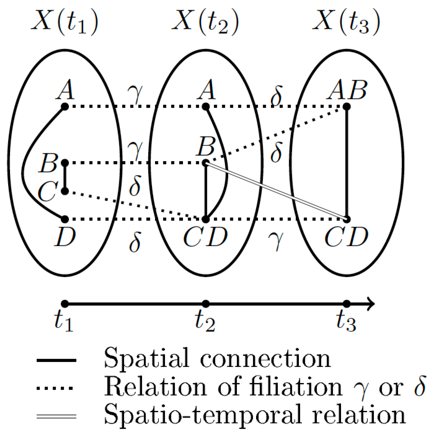
2.2.3. Spatio-Temporal Graphs
2.2.4. Spatio-Temporal Graphs and Semantic Graphs
2.2.5. Graph Analysis
3. Knowledge Graphs
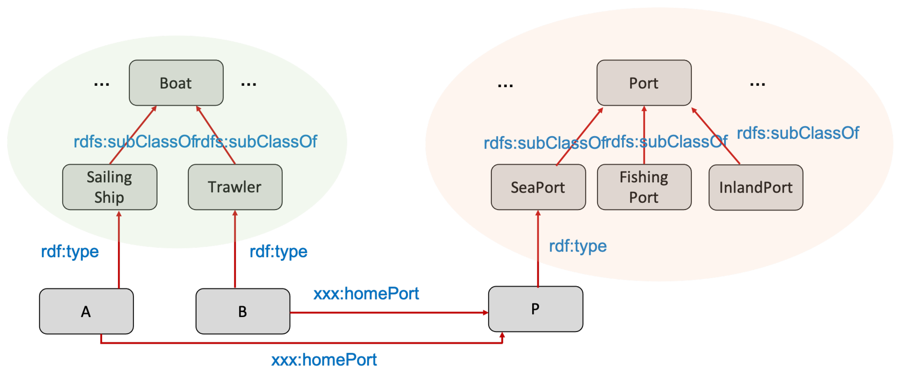
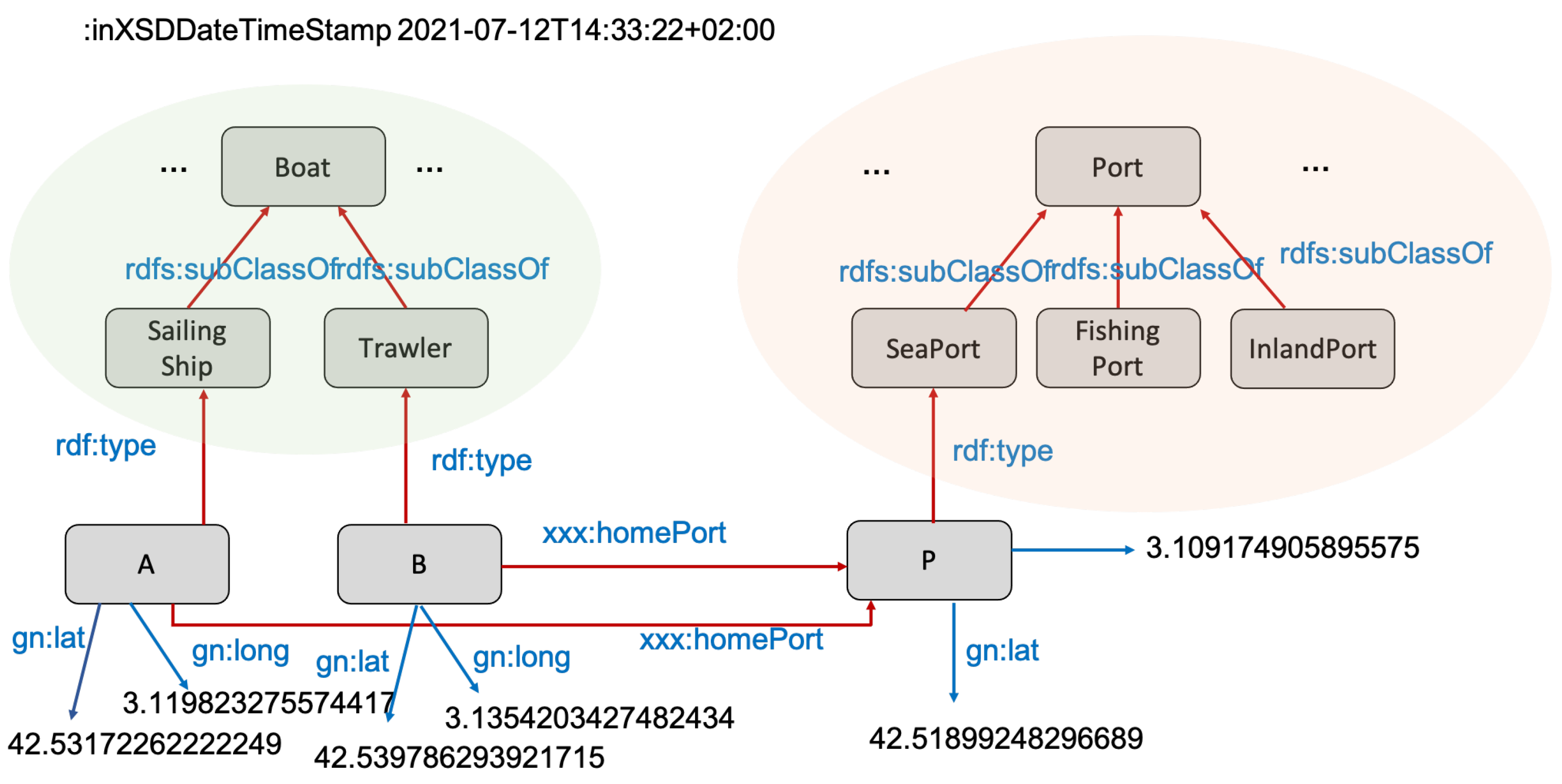
3.1. Knowledge Graphs: Main Principles
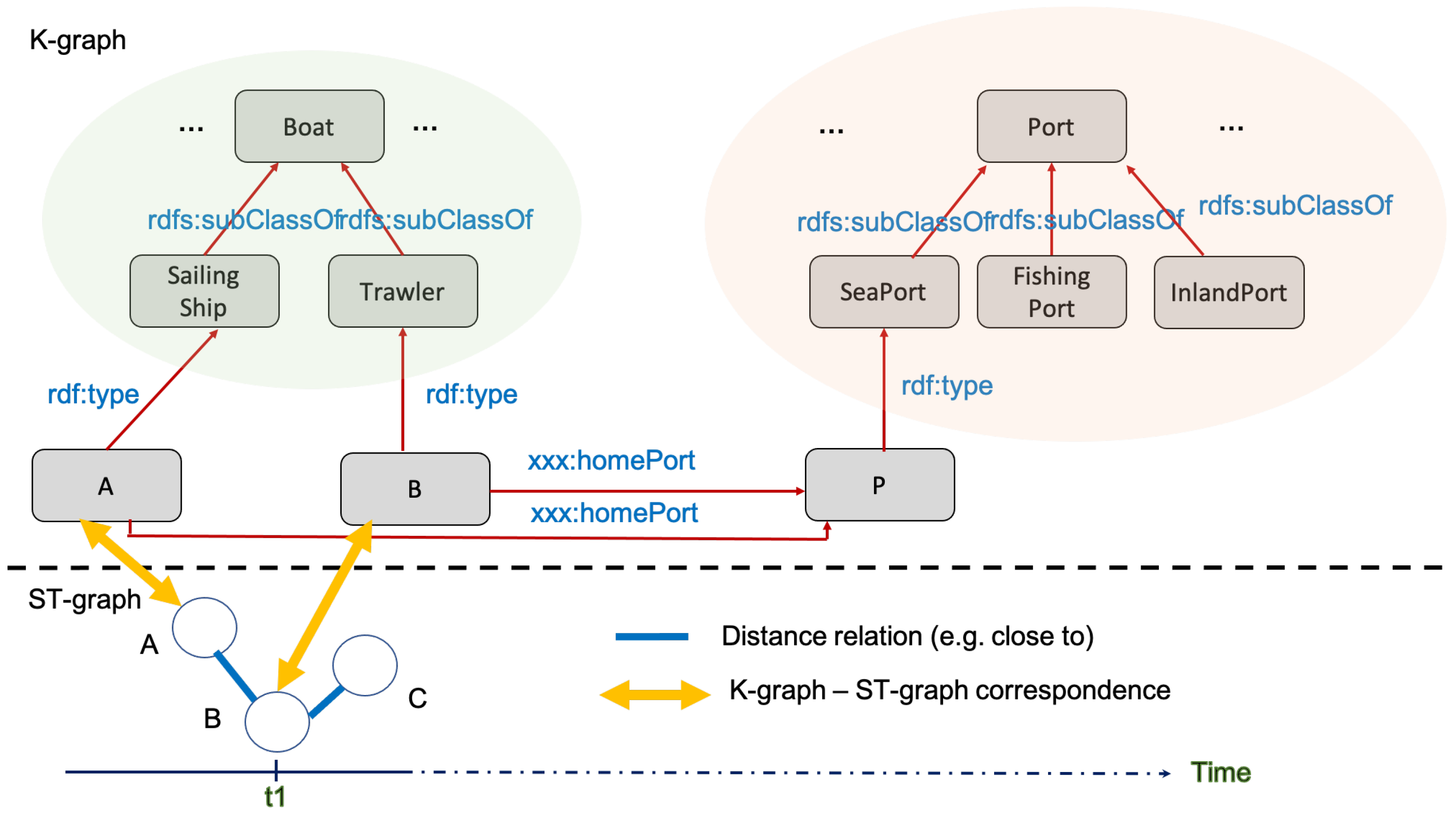
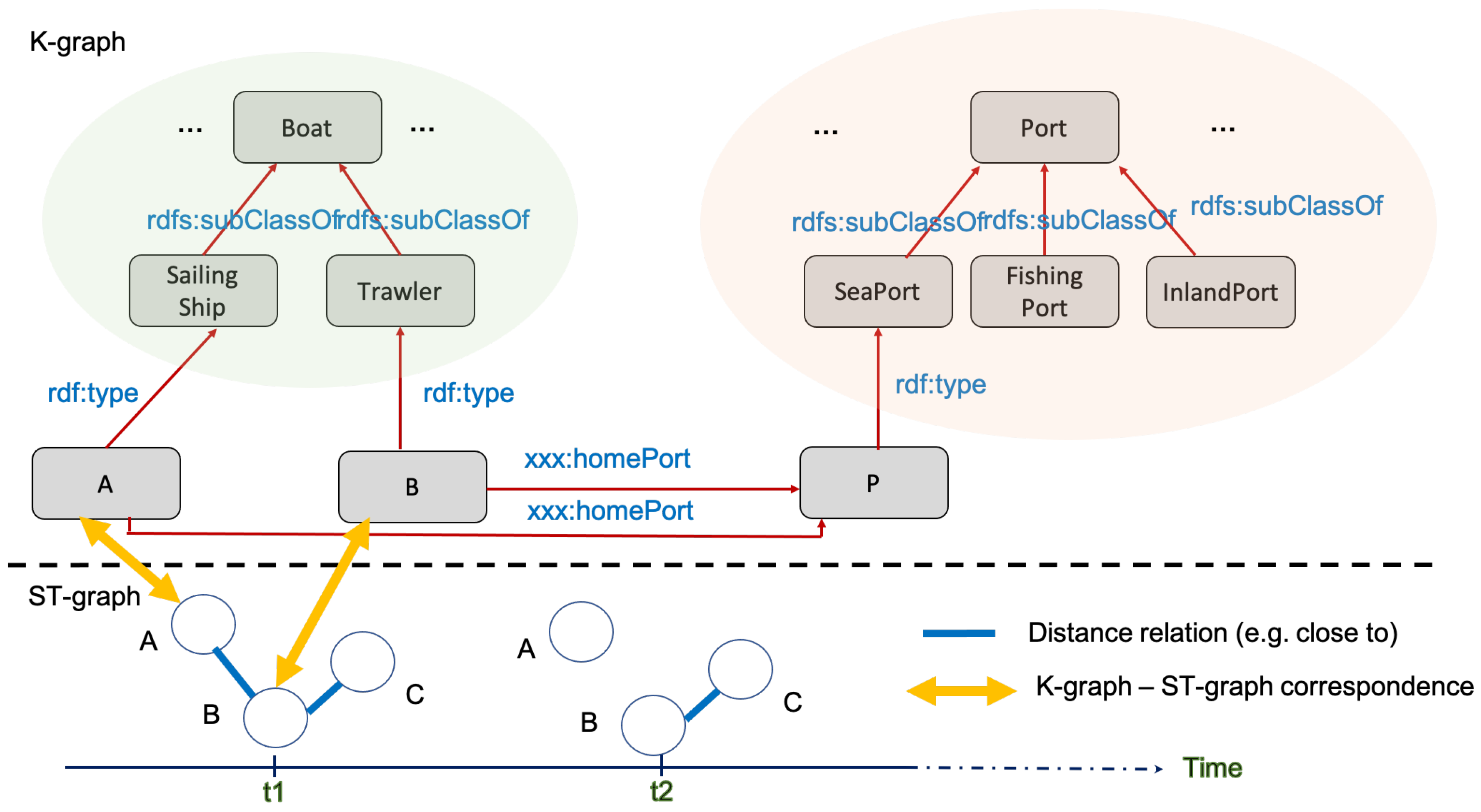
3.2. Spatio-Temporal Knowledge Graphs
4. Graphs and Knowledge Graphs in the Field of Maritime Transportation
4.1. Large Maritime Graphs
4.2. Ontology-Based and Knowledge Graph-Based Approaches in the Maritime Transport Domain
5. Discussion
5.1. From Knowledge Graphs to Spatio-Temporal Graphs
5.2. From Spatio-Temporal Graphs to Knowledge Graphs
6. Conclusions
Author Contributions
Funding
Institutional Review Board Statement
Informed Consent Statement
Conflicts of Interest
References
- Langran, G. A review of temporal database research and its use in GIS applications. Int. J. Geogr. Inf. Sci. 1989, 3, 215–232. [Google Scholar] [CrossRef]
- Peuquet, D. It’s About Time: A Conceptual Framework for the Representation of Temporal Dynamics in Geographic Information Systems. Ann. Assoc. Am. Geogr. 1984, 84, 441–461. [Google Scholar] [CrossRef]
- Claramunt, C.; Thériault, M. Managing Time in GIS: An Event-Oriented Approach. In Recent Advances in Temporal Databases, Proceedings of the International Workshop on Temporal Databases, Zürich, Switzerland, 17–18 September 1995; Clifford, J., Tuzhilin, A., Eds.; Workshops in Computing; Springer: Berlin/Heidelberg, Germany, 1995; pp. 23–42. [Google Scholar] [CrossRef]
- Spaccapietra, S.; Parent, C.; Damiani, M.L.; de Macedo, J.A.; Porto, F.; Vangenot, C. A conceptual view on trajectories. Data Knowl. Eng. 2008, 65, 126–146. [Google Scholar] [CrossRef] [Green Version]
- Siabato, W.; Claramunt, C.; Ilarri, S.; Manso-Callejo, M. A Survey of Modelling Trends in Temporal GIS. ACM Comput. Surv. 2018, 51, 30:1–30:41. [Google Scholar] [CrossRef] [Green Version]
- Galton, A. Space, Time and the Representation of Geographical Reality. In The Philosophy of GIS; Tambassi, T., Ed.; Springer International Publishing: Berlin/Heidelberg, Germany, 2019; pp. 75–97. [Google Scholar] [CrossRef]
- Yang, C.; Clarke, K.; Shekhar, S.; Tao, C.V. Big Spatiotemporal Data Analytics: A research and innovation frontier. Int. J. Geogr. Inf. Sci. 2020, 34, 1075–1088. [Google Scholar] [CrossRef] [Green Version]
- Del Mondo, G.; Stell, J.G.; Claramunt, C.; Thibaud, R. A Graph Model for Spatio-temporal Evolution. J. Univ. Comput. Sci. 2010, 16, 1452–1477. [Google Scholar] [CrossRef]
- Hogan, A.; Blomqvist, E.; Cochez, M.; d’Amato, C.; de Melo, G.; Gutiérrez, C.; Gayo, J.L.; Kirrane, S.; Neumaier, S.; Polleres, A.; et al. Knowledge Graphs. 2020. Available online: http://xxx.lanl.gov/abs/2003.02320 (accessed on 1 August 2021).
- Gao, J.; Qiu, P.; Yu, L.; Huang, Z.; Lu, F. An interpretable attraction recommendation method based on knowledge graph. Sci. Sin. Inf. 2020, 50, 1055–1068. [Google Scholar] [CrossRef]
- Qiu, P.; Yu, L.; Gao, J.; Lu, F. Detecting geo-relation phrases from web texts for triplet extraction of geographic knowledge: A context-enhanced method. Big Earth Data 2019, 3, 297–314. [Google Scholar] [CrossRef]
- Peng, P.; Cheng, S.; Lu, F. Characterizing the global liquefied petroleum gas trading community using mass vessel trajectory data. J. Clean. Prod. 2020, 252, 119883. [Google Scholar] [CrossRef]
- Peng, P.; Lu, F.; Cheng, S.; Yang, Y. Mapping the global liquefied natural gas trade network: A perspective of maritime transportation. J. Clean. Prod. 2021, 283, 124640. [Google Scholar] [CrossRef]
- Lu, F.; Yu, L.; Qiu, P. On geographic knowledge graph. J. Geo Inf. Sci. 2017, 6, 723–734. [Google Scholar] [CrossRef]
- Hillier, B.; Hanson, J. The Social Logic of Space; Cambridge University Press: Cambridge, UK, 1984. [Google Scholar] [CrossRef]
- Benedikt, M.L. To Take Hold of Space: Isovists and Isovist Fields. Environ. Plan. B 1979, 6, 47–65. [Google Scholar] [CrossRef]
- Turner, A.; Penn, A.; Hillier, B. An Algorithmic Definition of the Axial Map. Environ. Plan. B 2005, 32, 47–65. [Google Scholar] [CrossRef]
- Peponis, J.; Wineman, J.; Rashid, M.; Kim, S.H.; Bafna, S. On the description of shape and spatial configuration inside buildings: Convex partitions and their local properties. Environ. Plan. B 1997, 24, 761–781. [Google Scholar] [CrossRef]
- Ratti, C. Space syntax: Some inconsistencies. Environ. Plan. B 2004, 31, 487–499. [Google Scholar] [CrossRef]
- Domingo, M.; Thibaud, R.; Claramunt, C. A graph-based approach for the structural analysis of road and building layouts. Geo Spat. Inf. Sci. 2019, 22, 59–71. [Google Scholar] [CrossRef] [Green Version]
- Wang, Y.; Yin, H.; Chen, H.; Wo, T.; Xu, J.; Zheng, K. Origin-Destination Matrix Prediction via Graph Convolution: A New Perspective of Passenger Demand Modeling. In Proceedings of the KDD’19—25th ACM SIGKDD International Conference on Knowledge Discovery & Data Mining, Anchorage, AK, USA, 4–8 August 2019; pp. 1227–1235. [Google Scholar] [CrossRef]
- Nardo, A.D.; Giudicianni, C.; Greco, R.; Herrera, M.; Santonastaso, G.F. Applications of Graph Spectral Techniques to Water Distribution Network Management. Water 2018, 10, 45. [Google Scholar] [CrossRef] [Green Version]
- Fang, Y.; Cheng, R.; Li, X.; Luo, S.; Hu, J. Effective community search over large spatial graphs. In Proceedings of the VLDB Endowment, Munich, Germany, 28 August–1 September 2017; Volume 6, pp. 1227–1235. [Google Scholar] [CrossRef] [Green Version]
- Leonard, L.; MacEachren, A.M.; Madduri, K. Graph-based visual analysis for large-scale hydrological modeling. Inf. Vis. 2016, 16, 2015–2216. [Google Scholar] [CrossRef]
- Petelin, B.; Kononenko, I.; Malacic, V.; Kukar, M. Frequent subgraph mining in oceanographic multi-level. Int. J. Geogr. Inf. Sci. 2019, 33, 1936–1959. [Google Scholar] [CrossRef]
- Maduako, I.; Wachowicz, M. A space-time varying graph for modelling places and events in a network. Int. J. Geogr. Inf. Sci. 2019, 33, 1915–1935. [Google Scholar] [CrossRef]
- Stell, J.G. Granulation for graphs. In Spatial Information Theory. Cognitive and Computational Foundations of Geographic Information Science. International Conference COSIT’99, Volume 1661 of Lecture Notes in Computer Science; Springer: Berlin/Heidelberg, Germany, 1999; pp. 417–432. [Google Scholar] [CrossRef]
- Batty, M. Network Geography: Relations, Interactions, Scaling and Spatial Processes in GIS. In UCL Working Papers Series; Centre for Advanced Spatial Analysis: London, UK, 2003; Volume 63, ISSN 1467-1298. [Google Scholar]
- Claramunt, C.; Winter, S. Structural Salience of Elements of the City. Environ. Plan. B Plan. Des. 2007, 34, 1030–1050. [Google Scholar] [CrossRef]
- Jguirim, I.; Brosset, D.; Claramunt, C. Un Système de Génération d’Itinéraires des activités mobiles dans la ville. In Proceedings of the Actes de la 11ème Conférence Internationale Annuelle Spatial Analysis and GEOmatics, SAGEO 2015, Hammamet, Tunisia, 30 November 2015; pp. 46–59. [Google Scholar]
- Sriti, M.; Thibaud, R.; Claramunt, C. A network-based Model for representing the evolution of spatial structures. In Proceedings of the 4th ISPRS Workshop on Dynamic & Multi-Dimensional GIS, Pontypridd, UK, 5–8 September 2005; pp. 150–155. [Google Scholar]
- Rodier, X.; Couedic, M.L.; Hautefeuille, F.; Leturcq, S.; Jouve, B.; Fieux, E. From space to graphs to understand spatial changes using medieval and modern fiscal sources. In Proceedings of the 40th Annual Conference of Computer Applications and Quantitative Methods in Archaeology (CAA), Southampton, UK, 26–29 March 2012; Amsterdam University Press: Southampton, UK, 2012; pp. 424–431. [Google Scholar] [CrossRef]
- Meentemeyer, V. Geographical perspectives of space, time, and scale. Landsc. Ecol. 1989, 33, 163–173. [Google Scholar] [CrossRef]
- Frank, A.U.; Timpf, S. Multiple representations for cartographic objects in a multi-scale tree—An intelligent graphical zoom. Comput. Graph. 1994, 18, 823–829. [Google Scholar] [CrossRef]
- Auber, D.; Chiricota, Y.; Jourdan, F.; Melançon, G. Multiscale Visualization of Small World Networks. In Proceedings of the Ninth Annual IEEE Conference on Information Visualization—INFOVIS’03, Seattle, WA, USA, 19–21 October 2003; pp. 75–81. [Google Scholar] [CrossRef] [Green Version]
- Pinson, L.; Del Mondo, G.; Tranouez, P. Representation of interdependencies between urban networks by a multi-layer graph. In Proceedings of the 14th International Conference on Spatial Information Theory (COSIT 2019), Regensburg, Germany, 9–13 September 2019; Volume 142. [Google Scholar]
- Mainguenaud, M. Modelling the Network Component of Geographical Information Systems. Int. J. Geogr. Inf. Syst. 1995, 9, 575–593. [Google Scholar] [CrossRef]
- Walton, L.; Worboys, M.F. An Algebraic Approach to Image Schemas for Geographic Space. In Proceedings of the Spatial Information Theory, 9th International Conference, COSIT 2009, Aber Wrac’h, France, 21–25 September 2009; pp. 357–370. [Google Scholar] [CrossRef]
- Stell, J.G.; Del Mondo, G.; Thibaud, R.; Claramunt, C. Spatio-temporal Evolution as Bigraph Dynamics. In Proceedings of the Spatial Information Theory—10th International Conference, COSIT 2011, Belfast, ME, USA, 12–16 September 2011; pp. 148–167. [Google Scholar] [CrossRef]
- Allen, J.F. Towards a general theory of action and time. Artif. Intell. 1984, 23, 123–154. [Google Scholar] [CrossRef]
- Zhang, J.; Li, J.; Wang, S.; Liu, Z.; Yuan, Q.; Yang, F. On Retrieving Moving Objects Gathering Patterns from Trajectory Data via Spatio-temporal Graph. In Proceedings of the 2014 IEEE International Congress on Big Data, Anchorage, AK, USA, 27 June–2 July 2014; pp. 390–397. [Google Scholar] [CrossRef]
- Jiang, J.; Worboys, M.F. Event-based topology for dynamic planar areal objects. Int. J. Geogr. Inf. Sci. 2009, 23, 33–60. [Google Scholar] [CrossRef]
- Stell, J.G. Granularity in change over time. In Foundations of Geographic Information Science; Duckham, M., Goodchild, M., Worboys, M., Eds.; Taylor and Francis: Abingdon, UK, 2003; pp. 95–115. [Google Scholar] [CrossRef]
- Costes, B.; Perret, J.; Bucher, B.; Gribaudi, M. An aggregated graph to qualify historical spatial networks using temporal patterns detection. In Proceedings of the 18th AGILE International Conference on Geographic Information Science, Lisbon, Portugal, 9–12 June 2015. [Google Scholar]
- Bertrand, D. Un Système d’Information Géographique pour le Suivi d’Objets Historiques Urbaines à Travers l’Espace et le Temps. Ph.D. Thesis, EHESS, Paris, France, 2015. [Google Scholar]
- Oberoi, K.S.; Mondo, G.D.; Dupuis, Y.; Vasseur, P. Modeling Road Traffic Takes Time. In Proceedings of the 10th International Conference on Geographic Information Science (GIScience 2018), Dagstuhl, Germany, 28–31 August 2018; Schloss Dagstuhl–Leibniz-Zentrum fuer Informatik; Leibniz International Proceedings in Informatics (LIPIcs). Volume 114, pp. 52:1–52:7. [Google Scholar] [CrossRef]
- George, B.; Shekhar, S. Journal on Data Semantics XI; Chapter Time-Aggregated Graphs for Modeling Spatio-Temporal Networks; Springer: Berlin/Heidelberg, Germany, 2008; pp. 191–212. [Google Scholar] [CrossRef]
- Stell, J.G.; Worboys, M. Stratified map spaces: A formal basis for multi-resolution spatial databases. In Proceedings of the SDH’98 Proceedings 8th International Symposium on Spatial Data Handling, International Geographical, Vancouver, BC, Canada, 11–15 July 1998; pp. 180–189. [Google Scholar]
- Spéry, L.; Claramunt, C.; Libourel, T. A Spatio-Temporal Model for the Manipulation of Lineage Metadata. Geoinformatica 2001, 5, 51–70. [Google Scholar] [CrossRef]
- Harbelot, B.; Arenas, H.; Cruz, C. Continuum: A spatiotemporal data model to represent and qualify filiation relationships. In Proceedings of the 4th ACM SIGSPATIAL International Workshop on GeoStreaming, IWGS 2013, Orlando, FL, USA, 5 November 2013; Kashani, F.B., Basalamah, A., Zhang, C., Eds.; ACM: New York, NY, USA, 2013; pp. 76–85. [Google Scholar] [CrossRef]
- Sridhar, M.; Cohn, A.G.; Hogg, D.C. Benchmarking Qualitative Spatial Calculi for Video Activity Analysis. In Proceedings of the IJCAI Workshop Benchmarks and Applications of Spatial Reasoning, Barcelona, Spain, 16–18 July 2011; pp. 15–20. [Google Scholar]
- Guyet, T.; Moinard, Y.; Quiniou, R. Programmation par ensembles réponses pour simuler l’assolement d’un paysage. Rev. d’Intell. Artif. 2015, 29, 293–320. [Google Scholar] [CrossRef] [Green Version]
- Wylot, M.; Hauswirth, M.; Cudré-Mauroux, P.; Sakr, S. RDF Data Storage and Query Processing Schemes: A Survey. ACM Comput. Surv. 2018, 51, 84:1–84:36. [Google Scholar] [CrossRef]
- Ehrlinger, L.; Wöß, W. Towards a Definition of Knowledge Graphs. In Proceedings of the Posters and Demos Track of the 12th International Conference on Semantic Systems—SEMANTiCS2016 and the 1st International Workshop on Semantic Change & Evolving Semantics (SuCCESS’16) Co-Located with the 12th International Conference on Semantic Systems (SEMANTiCS 2016), Leipzig, Germany, 12–15 September 2016; Volume 1695. [Google Scholar]
- Ingalalli, V.; Ienco, D.; Poncelet, P. Mining frequent subgraphs in multigraphs. Inf. Sci. 2018, 451–452, 50–66. [Google Scholar] [CrossRef] [Green Version]
- Ji, S.; Pan, S.; Cambria, E.; Marttinen, P.; Yu, P.S. A Survey on Knowledge Graphs: Representation, Acquisition and Applications. 2020. Available online: http://xxx.lanl.gov/abs/2002.00388 (accessed on 1 August 2021).
- Fensel, D.; Simsek, U.; Angele, K.; Huaman, E.; Kärle, E.; Panasiuk, O.; Toma, I.; Umbrich, J.; Wahler, A. Knowledge Graphs—Methodology, Tools and Selected Use Cases; Springer: Berlin/Heidelberg, Germany, 2020. [Google Scholar] [CrossRef]
- Clementini, E.; Sharma, J.; Egenhofer, M. Modelling topological spatial relations: Strategies for query processing. Comput. Graph. 1994, 18, 815–822. [Google Scholar] [CrossRef]
- Egenhofer, M. A Formal Definition of Binary Topological Relationships. In Foundations of Data Organization and Algorithms, Proceedings of the 3rd International Conference, FODO 1989, Paris, France, 21–23 June 1989; Litwin, W., Schek, H., Eds.; Lecture Notes in Computer Science; Springer: Berlin/Heidelberg, Germany, 1989; Volume 367, pp. 457–472. [Google Scholar] [CrossRef]
- Cohn, A.; Bennett, B.; Gooday, J.; Gotts, N.M. Qualitative Spatial Representation and Reasoning with the Region Connection Calculus. GeoInformatica 1997, 1, 275–316. [Google Scholar] [CrossRef]
- Ioannidis, T.; Garbis, G.; Kyzirakos, K.; Bereta, K.; Koubarakis, M. Evaluating Geospatial RDF Stores Using the Benchmark Geographica 2. 2019. Available online: http://xxx.lanl.gov/abs/1906.01933 (accessed on 1 August 2021).
- Bereta, K.; Xiao, G.; Koubarakis, M. Ontop-spatial: Ontop of geospatial databases. J. Web Semant. 2019, 58, 100514. [Google Scholar] [CrossRef]
- Calvanese, D.; Cogrel, B.; Komla-Ebri, S.; Kontchakov, R.; Lanti, D.; Rezk, M.; Rodriguez-Muro, M.; Xiao, G. Ontop: Answering SPARQL queries over relational databases. Semant. Web 2017, 8, 471–487. [Google Scholar] [CrossRef] [Green Version]
- Christen, P. A Survey of Indexing Techniques for Scalable Record Linkage and Deduplication. IEEE Trans. Knowl. Data Eng. 2012, 24, 1537–1555. [Google Scholar] [CrossRef] [Green Version]
- Christophides, V.; Efthymiou, V.; Stefanidis, K. Entity Resolution in the Web of Data; Synthesis Lectures on the Semantic Web; Theory and Technology, Morgan & Claypool Publishers: San Rafael, CA, USA, 2015. [Google Scholar] [CrossRef] [Green Version]
- Ngomo, A.N.; Auer, S. LIMES—A Time-Efficient Approach for Large-Scale Link Discovery on the Web of Data. In Proceedings of the 22nd International Joint Conference on Artificial Intelligence, Barcelona, Spain, 16–22 July 2011; pp. 2312–2317. [Google Scholar] [CrossRef]
- Nentwig, M.; Hartung, M.; Ngomo, A.N.; Rahm, E. A survey of current Link Discovery frameworks. Semant. Web 2017, 8, 419–436. [Google Scholar] [CrossRef] [Green Version]
- Bhardwaj, P.; Debruyne, C.; O’Sullivan, D. On the Overlooked Challenges of Link Discovery. In Proceedings of the 3rd International Workshop on Geospatial Linked Data and the 2nd Workshop on Querying the Web of Data Co-Located with 15th Extended Semantic Web Conference (ESWC 2018), Heraklion, Greece, 3 June 2018; Volume 2110, pp. 41–46. [Google Scholar]
- Isele, R.; Jentzsch, A.; Bizer, C. Efficient Multidimensional Blocking for Link Discovery without losing Recall. In Proceedings of the 14th International Workshop on the Web and Databases 2011—WebDB 2011, Athens, Greece, 12 June 2011. [Google Scholar]
- Nikolaou, C.; Dogani, K.; Bereta, K.; Garbis, G.; Karpathiotakis, M.; Kyzirakos, K.; Koubarakis, M. Sextant: Visualizing time-evolving linked geospatial data. J. Web Semant. 2015, 35, 35–52. [Google Scholar] [CrossRef] [Green Version]
- Shbita, B.; Knoblock, C.; Duan, W.; Chiang, Y.; Uhl, J.; Leyk, S. Building Linked Spatio-Temporal Data from Vectorized Historical Maps. In The Semantic Web, Proceedings of the 17th International Conference, ESWC 2020, Heraklion, Greece, 31 May–4 June 2020; Harth, A., Kirrane, S., Ngomo, A.N., Paulheim, H., Rula, A., Gentile, A.L., Haase, P., Cochez, M., Eds.; Lecture Notes in Computer Science; Springer: Berlin/Heidelberg, Germany, 2020; Volume 12123, pp. 409–426. [Google Scholar] [CrossRef]
- Bucher, B.; Tiainen, E.; von Brasch, T.E.; Janssen, P.; Kotzinos, D.; Ceh, M.; Rijsdijk, M.; Folmer, E.; Damme, M.V.; Zhral, M. Conciliating Perspectives from Mapping Agencies and Web of Data on Successful European SDIs: Toward a European Geographic Knowledge Graph. ISPRS Int. J. Geo Inf. 2020, 9, 62. [Google Scholar] [CrossRef] [Green Version]
- Kuhn, W.; Kauppinen, T.; Janowicz, K. Linked Data—A Paradigm Shift for Geographic Information Science. In Geographic Information Science, Proceedings of the 8th International Conference, GIScience 2014, Vienna, Austria, 24–26 September 2014; Duckham, M., Pebesma, E., Stewart, K., Frank, A., Eds.; Lecture Notes in Computer Science; Springer: Berlin/Heidelberg, Germany, 2014; Volume 8728, pp. 173–186. [Google Scholar] [CrossRef] [Green Version]
- Mai, G.; Janowicz, K.; Yan, B.; Scheider, S. Deeply integrating Linked Data with Geographic Information Systems. Trans. GIS 2019, 23, 579–600. [Google Scholar] [CrossRef]
- Trivedi, R.; Dai, H.; Wang, Y.; Song, L. Know-Evolve: Deep Temporal Reasoning for Dynamic Knowledge Graphs. In Proceedings of the 34th International Conference on Machine Learning, ICML 2017, Sydney, Australia, 6–11 August 2017; Volume 70, pp. 3462–3471. [Google Scholar]
- Everwyn, J.; Mouaddib, A.; Zanuttini, B.; Gatepaille, S.; Brunessaux, S. Link Prediction on Dynamic Attributed Knowledge Graphs for Maritime Situational Awareness. In Proceedings of the Conférence Nationale sur les Applications Pratiques de l’Intelligence Artificielle (APIA 2019), Toulouse, France, 1–2 July 2019. [Google Scholar]
- Peng, P.; Cheng, S.; Chen, J.; Liao, M.; Wu, L.; Liu, X.; Lu, F. A fine-grained perspective on the robustness of global cargo ship transportation networks. J. Geogr. Sci. 2018, 28, 881–889. [Google Scholar] [CrossRef] [Green Version]
- Kaluza, P.; Kölzsch, A.; Gastner, M.T.; Blasius, B. The complex network of global cargo ship movements. J. R. Soc. Interface 2010, 7, 1093–1103. [Google Scholar] [CrossRef] [PubMed]
- Wilmsmeier, G.; Monios, J. Geographies of maritime transport. In Geographies of Maritime Transport; Edward Elgar Publishing: Cheltenham, UK, 2020. [Google Scholar] [CrossRef] [Green Version]
- Claramunt, C.; Ray, C.; Salmon, L.; Camossi, E.; Hadzagic, M.; Jousselme, A.; Andrienko, G.; Andrienko, N.; Theodoridis, Y.; Vouros, G. Maritime data integration and analysis: Recent progress and research challenges. Adv. Database Technol. EDBT 2017, 2017, 192–197. [Google Scholar] [CrossRef]
- Liu, C.; Wang, J.; Zhang, H. Spatial heterogeneity of ports in the global maritime network detected by weighted ego network analysis. Marit. Policy Manag. 2018, 45, 89–104. [Google Scholar] [CrossRef]
- Ducruet, C.; Notteboom, T.E. The worldwide maritime network of container shipping: Spatial structure and regional dynamics. Glob. Netw. 2012, 12, 395–423. [Google Scholar] [CrossRef] [Green Version]
- Liu, C.; Wang, J.; Zhang, H.; Yin, M. Mapping the hierarchical structure of the global shipping network by weighted ego network analysis. Int. J. Shipp. Transp. Logist. 2018, 10, 63–86. [Google Scholar] [CrossRef]
- Pan, J.; Bell, M.G.H.; Cheung, K.; Perera, S.; Yu, H. Connectivity analysis of the global shipping network by eigenvalue decomposition. Marit. Policy Manag. 2019, 46, 957–966. [Google Scholar] [CrossRef]
- Cazzaniga-Francesetti, D.; Foschi, A. The impact of hub and spokes networks in the Mediterranean peculiarity. In Proceedings of the 2002 IAME Annual Conference Panama, Panama City, Panama, 13–15 November 2002. [Google Scholar]
- Notteboom, T.E. Container shipping and ports: An overview. Rev. Netw. Econ. 2004, 3. [Google Scholar] [CrossRef] [Green Version]
- Woolley-Meza, O.; Thiemann, C.; Grady, D.; Jungbin, L.J.; Seebens, H.; Blasius, B.; Brockmann, D. Complexity in human transportation networks: A comparative analysis of worldwide air transportation and global cargo-ship movements. Eur. Phys. J. B 2011, 84, 589–600. [Google Scholar] [CrossRef] [Green Version]
- Ducruet, C.; Zaidi, F. Maritime constellations: A complex network approach to shipping and ports. Marit. Policy Manag. 2012, 39, 151–168. [Google Scholar] [CrossRef]
- Ducruet, C. Network diversity and maritime flows. J. Transp. Geogr. 2013, 30, 77–88. [Google Scholar] [CrossRef] [Green Version]
- Xu, X.; Hu, J.; Lu, F. Empirical analysis of the ship-transport network of China. Chaos Interdiscip. J. Nonlinear Sci. 2007, 17, 023129. [Google Scholar] [CrossRef] [PubMed] [Green Version]
- Hu, Y.; Zhu, D. Empirical analysis of the worldwide maritime transportation network. Phys. A Stat. Mech. Appl. 2009, 388, 2061–2071. [Google Scholar] [CrossRef] [Green Version]
- Ducruet, C. Multilayer dynamics of complex spatial networks: The case of global maritime flows (1977–2008). J. Transp. Geogr. 2017, 60, 47–58. [Google Scholar] [CrossRef] [Green Version]
- Yu, H.; Fang, Z.; Lu, F.; Murray, A.; Zhao, Z.; Xu, Y.; Yang, X. Massive automatic identification system sensor trajectory data-based multi-layer linkage network dynamics of maritime transport along 21st-century maritime silk road. Sensors 2019, 19, 4197. [Google Scholar] [CrossRef] [PubMed] [Green Version]
- Peng, P.; Cheng, S.; Liu, X.; Mei, Q.; Lu, F. The robustness evaluation of global maritime transportation networks. Acta Geogr. Sin 2017, 72, 2241–2251. [Google Scholar] [CrossRef]
- Ducruet, C.; Lee, S.; Ng, K.A. Centrality and vulnerability in liner shipping networks: Revisiting the Northeast Asian port hierarchy. Marit. Policy Manag. 2010, 37, 17–36. [Google Scholar] [CrossRef]
- Ducruet, C. The polarization of global container flows by interoceanic canals: Geographic coverage and network vulnerability. Marit. Policy Manag. 2016, 43, 242–260. [Google Scholar] [CrossRef] [Green Version]
- Bartholdi, J.; Jarumaneeroj, P.; Ramudhin, A. A new connectivity index for container ports. Marit. Econ. Logist. 2016, 18, 231–249. [Google Scholar] [CrossRef] [Green Version]
- Wang, Y.; Cullinane, K. Measuring container port accessibility: An application of the Principal Eigenvector Method (PEM). Marit. Econ. Logist. 2008, 10, 75–89. [Google Scholar] [CrossRef]
- Peng, P.; Yang, Y.; Lu, F.; Cheng, S.; Mou, N.; Yang, R. Modelling the competitiveness of the ports along the Maritime Silk Road with big data. Transp. Res. Part A Policy Pract. 2018, 118, 852–867. [Google Scholar] [CrossRef]
- Wang, Y.; Cullinane, K. Traffic consolidation in East Asian container ports: A network flow analysis. Transp. Res. Part A Policy Pract. 2014, 61, 152–163. [Google Scholar] [CrossRef]
- Mou, N.; Liu, C.; Zhang, L.; Fu, X.; Xie, Y.; Li, Y.; Peng, P. Spatial pattern and regional relevance analysis of the maritime silk road shipping network. Sustainability 2018, 10, 977. [Google Scholar] [CrossRef] [Green Version]
- Wang, Y.; Cullinane, K. Determinants of port centrality in maritime container transportation. Transp. Res. Part E Logist. Transp. 2016, 95, 326–340. [Google Scholar] [CrossRef]
- Peng, P.; Poon, J.P.; Yan, Y.; Lu, F.; Cheng, S. Global oil traffic network and diffusion of influence among ports using real time data. Energy 2019, 172, 333–342. [Google Scholar] [CrossRef]
- Peng, P.; Lu, F. Mapping the Port Influence Diffusion Patterns: A Case Study of Rotterdam, Antwerp and Singapore. In Proceedings of the International Conference on Computational Science, Amsterdam, The Netherlands, 3–5 June 2020; Springer: Berlin/Heidelberg, Germany, 2020; pp. 266–276. [Google Scholar] [CrossRef]
- Fang, Z.; Yu, H.; Lu, F.; Feng, M.; Huang, M. Maritime network dynamics before and after international events. J. Geogr. Sci. 2018, 28, 937–956. [Google Scholar] [CrossRef] [Green Version]
- Yu, H.; Fang, Z.; Lu, F.; Murray, A.; Zhang, H.; Peng, P.; Mei, Q.; Chen, J. Impact of oil price fluctuations on tanker maritime network structure and traffic flow changes. Appl. Energy 2019, 237, 390–403. [Google Scholar] [CrossRef]
- Peng, P.; Yang, Y.; Cheng, S.; Lu, F.; Yuan, Z. Hub-and-spoke structure: Characterizing the global crude oil transport network with mass vessel trajectories. Energy 2019, 168, 966–974. [Google Scholar] [CrossRef]
- Laxe, F.G.; Seoane, M.J.; Montes, C.P. Maritime degree, centrality and vulnerability: Port hierarchies and emerging areas in containerized transport (2008–2010). J. Transp. Geogr. 2012, 24, 33–44. [Google Scholar] [CrossRef]
- Wang, L.; Zhu, Y.; Ducruet, C.; Bunel, M.; Lau, Y. From hierarchy to networking: The evolution of the “twenty-first-century Maritime Silk Road” container shipping system. Transp. Rev. 2018, 38, 416–435. [Google Scholar] [CrossRef]
- Kosowska-Stamirowska, Z. Network effects govern the evolution of maritime trade. Proc. Natl. Acad. Sci. USA 2020, 117, 12719–12728. [Google Scholar] [CrossRef]
- Katsumi, M.; Fox, M. Ontologies for transportation research: A survey. Transp. Res. Part C 2018, 89, 53–82. [Google Scholar] [CrossRef]
- Villa, P.; Camossi, E. A Description Logic Approach to Discover Suspicious Itineraries from Maritime Container Trajectories. In GeoSpatial Semantics, Proceedings of the 4th International Conference, GeoS 2011, Brest, France, 12–13 May 2011; Claramunt, C., Levashkin, S., Bertolotto, M., Eds.; Lecture Notes in Computer Science; Springer: Berlin/Heidelberg, Germany, 2011; Volume 6631, pp. 182–199. [Google Scholar] [CrossRef]
- Vandecasteele, A.; Napoli, A. An enhanced spatial reasoning ontology for maritime anomaly detection. In Proceedings of the 7th International Conference on System of Systems Engineering, SoSE 2012, Genova, Italy, 16–19 July 2012; pp. 247–252. [Google Scholar] [CrossRef] [Green Version]
- Lange, A.; Pirovano, G.; Pozzi, R.; Rossi, T. Development of a Container Terminal Simulation Ontology. Simul. Notes Eur. 2014, 24, 79–86. [Google Scholar] [CrossRef]
- Hagaseth, M.; Lohrmann, L.; Ruiz, A.; Oikonomou, F.; Roythorne, D.; Rayot, S. An Ontology for Digital Maritime Regulations. J. Marit. Res. 2016, 12, 7–18. [Google Scholar]
- Pileggi, S.; Indorf, M.; Nagi, A.; Kersten, W. CoRiMaS—An Ontological Approach to Cooperative Risk Management in Seaports. Sustainability 2020, 12, 4767. [Google Scholar] [CrossRef]
- Wen, Y.; Zhang, Y.; Huang, L.; Zhou, C.; Xiao, C.; Zhang, F.; Peng, X.; Zhan, W.; Sui, Z. Semantic Modelling of Ship Behavior in Harbor Based on Ontology and Dynamic Bayesian Network. ISPRS Int. J. Geo Inf. 2019, 8, 107. [Google Scholar] [CrossRef] [Green Version]
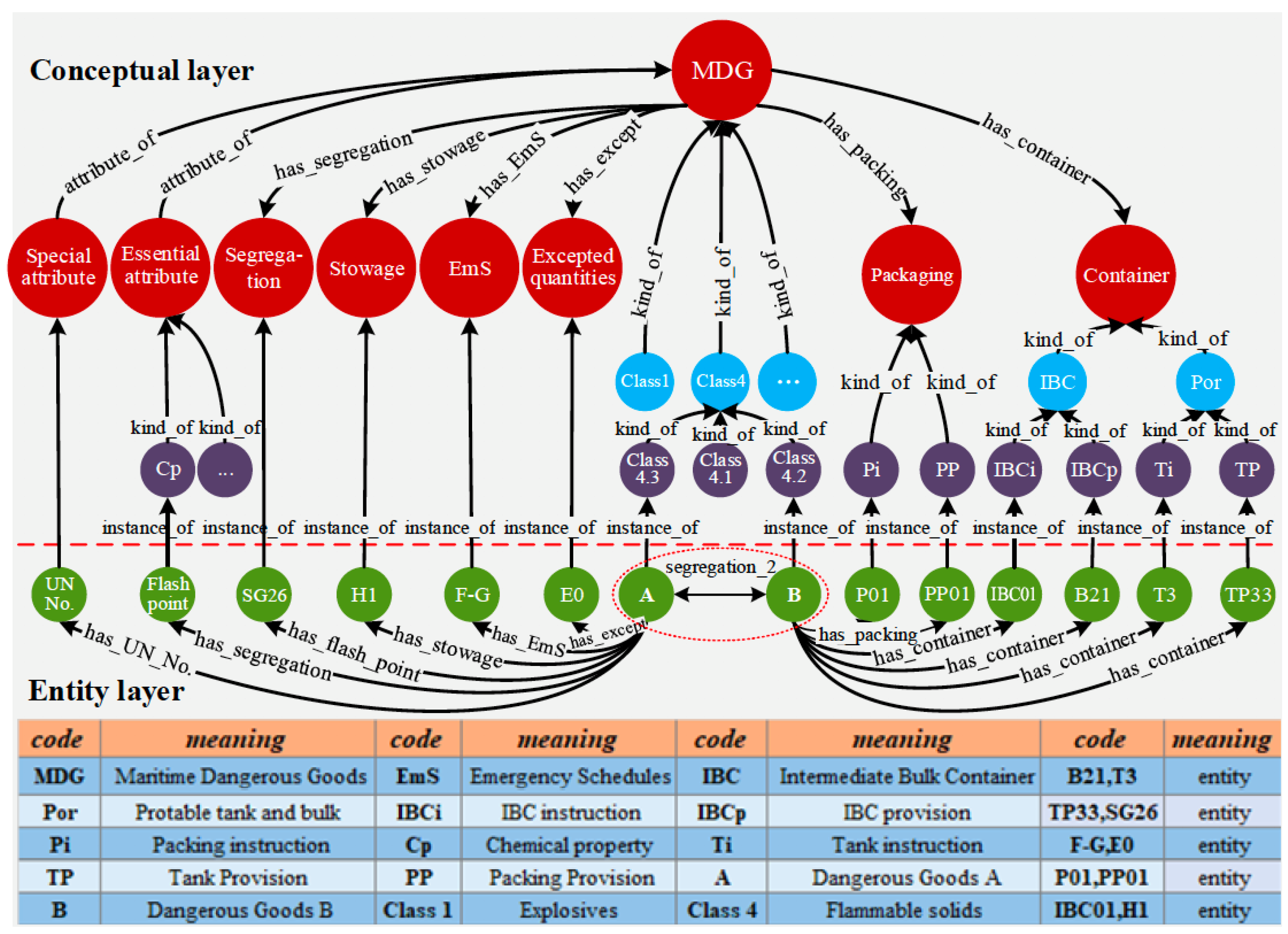
- Zhang, Q.; Wen, Y.; Zhou, C.; Long, H.; Han, D.; Zhang, F.; Xiao, C. Construction of Knowledge Graphs for Maritime Dangerous Goods. Sustainability 2019, 11, 2849. [Google Scholar] [CrossRef] [Green Version]
- Bordes, A.; Usunier, N.; García-Durán, A.; Weston, J.; Yakhnenko, O. Translating Embeddings for Modeling Multi-relational Data. In Proceedings of the Advances in Neural Information Processing Systems 26: 27th Annual Conference on Neural Information Processing Systems 2013, Lake Tahoe, NV, USA, 5–8 December 2013; pp. 2787–2795. [Google Scholar]
- Heidari, S.; Simmhan, Y.; Calheiros, R.N.; Buyya, R. Scalable Graph Processing Frameworks: A Taxonomy and Open Challenges. ACM Comput. Surv. 2018, 51, 60:1–60:53. [Google Scholar] [CrossRef]
- Hernández, D.; Hogan, A.; Riveros, C.; Rojas, C.; Zerega, E. Querying Wikidata: Comparing SPARQL, Relational and Graph Databases. In Proceedings of the Semantic Web—ISWC 2016—15th International Semantic Web Conference, Kobe, Japan, 17–21 October 2016; Volume 9982, pp. 88–103. [Google Scholar] [CrossRef]
- Pérez, J.; Arenas, M.; Gutiérrez, C. Semantics and complexity of SPARQL. ACM Trans. Database Syst. 2009, 34, 16:1–16:45. [Google Scholar] [CrossRef] [Green Version]
- Claramunt, C. Ontologies for geospatial information: Progress and challenges ahead. J. Spat. Inf. Sci. 2020, 20, 35–41. [Google Scholar] [CrossRef]


Publisher’s Note: MDPI stays neutral with regard to jurisdictional claims in published maps and institutional affiliations. |
© 2021 by the authors. Licensee MDPI, Basel, Switzerland. This article is an open access article distributed under the terms and conditions of the Creative Commons Attribution (CC BY) license (https://creativecommons.org/licenses/by/4.0/).
Share and Cite
Del Mondo, G.; Peng, P.; Gensel, J.; Claramunt, C.; Lu, F. Leveraging Spatio-Temporal Graphs and Knowledge Graphs: Perspectives in the Field of Maritime Transportation. ISPRS Int. J. Geo-Inf. 2021, 10, 541. https://doi.org/10.3390/ijgi10080541
Del Mondo G, Peng P, Gensel J, Claramunt C, Lu F. Leveraging Spatio-Temporal Graphs and Knowledge Graphs: Perspectives in the Field of Maritime Transportation. ISPRS International Journal of Geo-Information. 2021; 10(8):541. https://doi.org/10.3390/ijgi10080541
Chicago/Turabian StyleDel Mondo, Géraldine, Peng Peng, Jérôme Gensel, Christophe Claramunt, and Feng Lu. 2021. "Leveraging Spatio-Temporal Graphs and Knowledge Graphs: Perspectives in the Field of Maritime Transportation" ISPRS International Journal of Geo-Information 10, no. 8: 541. https://doi.org/10.3390/ijgi10080541