1. Introduction
The implementation of the European Water Framework Directive (WFD) (Directive 2000/60/EC) in the year 2000 is key to water management in the European Union. It aims at improving the ecological and chemical status of all surface and groundwater bodies. By 2027, all natural surface water bodies should show at least good chemical and ecological status. All heavily modified and artificial water bodies should accordingly have at least good chemical and ecological potential. Nowadays, although the original deadline has long passed, large parts of the European surface waters in many countries are failing to meet the set targets of the WFD. Only about 40% achieve good ecological status. Germany belongs to the countries where the situation is even worse with around 90% of its waters not meeting the targets [
1,
2]. This also corresponds to the situation in the German Federal State of Lower Saxony [
3]. It is widely recognized that the main reason for the failure of the achievement of good ecological status is due to hydromorphological alterations by human activities [
1,
4,
5,
6,
7].
The evaluation of the ecological status of running waters is based primarily on biological objectives, supported by physicochemical and hydromorphological parameters [
3,
8,
9]. Today, it is recognized that the assessment of the hydromorphological condition of rivers is crucial for the evaluation of the ecological status [
10,
11,
12,
13,
14]. Worldwide, various methods are used to assess the hydromorphological river quality. The methods differ widely regarding their concepts, spatial scales, aims and the collected data [
5,
12,
15,
16,
17]. Even within Europe, different methods are used within the framework of the Water Framework Directive [
18,
19,
20,
21,
22].
In Germany, the German field survey method has been developed for river hydromorphological assessment. It is a physical habitat assessment method, based on extensive field surveys. It has been developed by the German Working Group on Water Issues of the Federal States and the Federal Government (“Bund/Länder Arbeitsgemeinschaft Wasser”, LAWA) [
22,
23]. It is an on-site method and consists of a combination of an index-based evaluation of the river and an evaluation of the functional units. This approach ensures a validity check of the results of each river assessment [
23,
24,
25].
To adjust the evaluation to the specific regional conditions, a reference-based classification scheme according to georegion (alpine and subalpine, highlands, lowlands, independent), hydrology (creeks, small and large rivers, streams) and chemistry (carbonate, silicate) is used. In Germany, 25 different LAWA river types have been classified [
26]. To evaluate the status of the structure of the water courses, reference river sections for each river type have been designated with which the actual status can be compared. These reference river types serve as a model (“Leitbild”) for the river development and represent the potential natural condition of a river [
23,
24,
27,
28,
29].
Although there is the jointly developed LAWA field survey method in Germany, many Federal States use their own versions of the LAWA method, some of which deviate considerably from the original method. The German field survey method (LAWA) in general has been proven to be an effective, robust and easy-to use tool to assess the hydromorphological river quality [
9,
30]. However, the robustness of the method tends to decrease with increasing level of detail. Meier [
30] has shown that in some cases there is a considerable bias of the robustness of the single and main parameters between different versions of the method. Today, there is often still insufficient awareness of the limitations and strengths of the methods used by the implementing agencies or subcontracted consultancies [
12].
The river assessment of the German field survey method and the different versions of the Federal States are aimed to work likewise for every landscape type and every river type. Here, the question arises whether a uniform evaluation method performs similarly well if a river crosses different ecoregions or landscape types and, therefore, also exhibits different river types. For this aim, the Hase River in Lower Saxony was studied. Does the reference-based assessment of Lower Saxony allow enough modification when rivers change from one ecoregion to another? The aim of this study is not to make a general comparison between two ecoregions, but to assess the special situations, if one river crosses two different ecoregions, e.g., from the highlands to the lowlands.
The objectives of this study therefore are:
To compare the results of the reference-based quality assessment of the river Hase in Lower Saxony in two different ecoregions in order to define the main parameters responsible for these differences;
To estimate to what degree the variations in the results of the quality assessment are due to the actual hydromorphological differences or due to artefacts in the evaluation scheme;
To recommend improvements to the reference-based evaluation scheme of Lower Saxony.
2. Materials and Methods
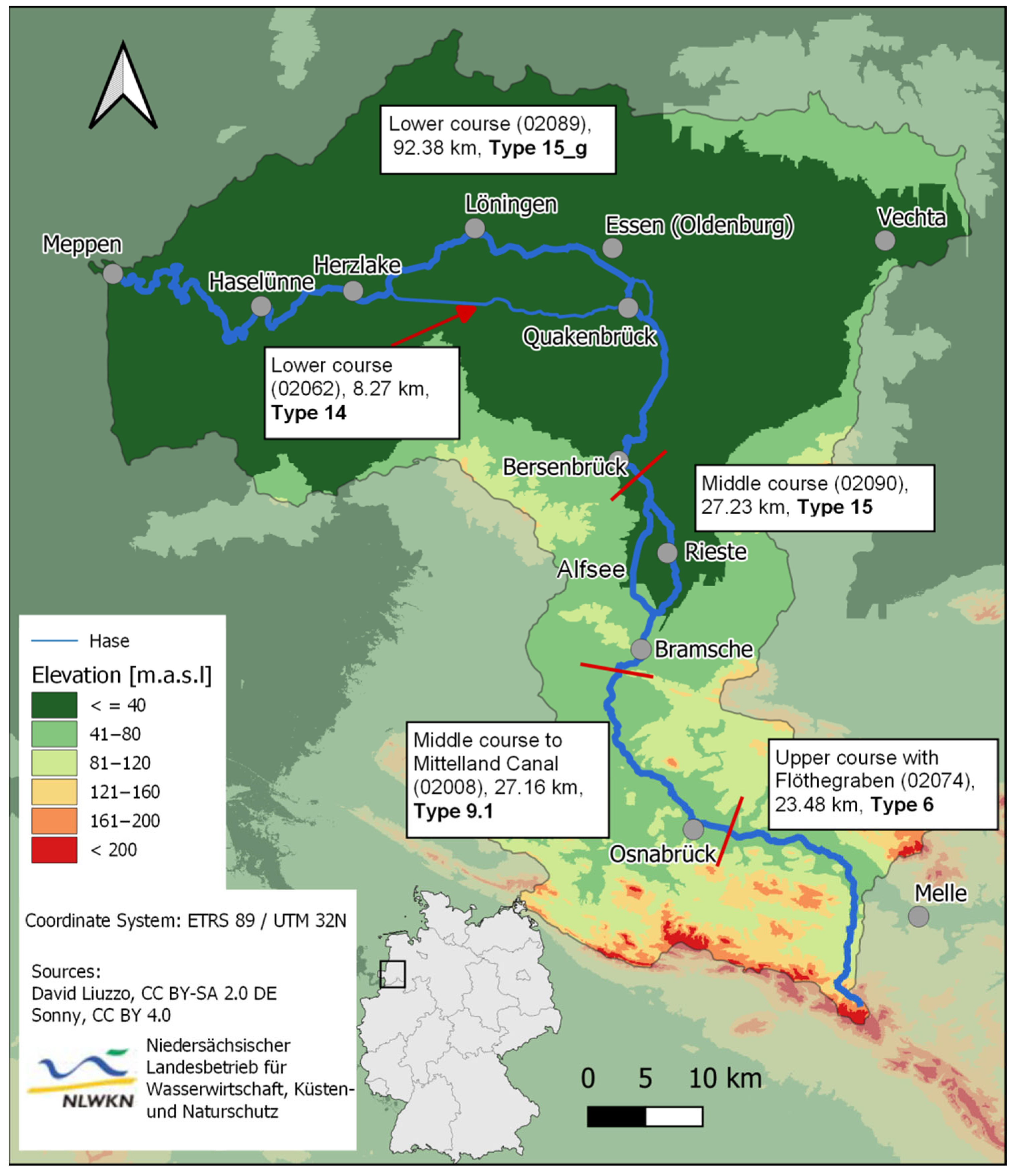
To achieve these objectives, the Hase River was chosen as a case example (
Figure 1). The Hase River is located in Southwestern Lower Saxony and is the biggest tributary of the Ems River. The aboveground catchment area extends over 3086 km
2 of which 118 km
2 belong to North Rhine-Westphalia. The Hase River originates near Melle in the Teutoburg(er) Forest and, after 170 km, flows into the Ems River near Meppen. The mean annual precipitation in the catchment is 750 mm, whereas the precipitation in the catchment of the upper course exceeds the precipitation in the middle and lower courses. The long-term mean annual discharge at the measurement station in Herzlake is 21.3 m
3 s
−1. The low water discharge is 1.22 m
3 s
−1 and the high water discharge can reach up to 152 m
3 s
−1. The catchment area of the Hase belongs to the landscape areas “Flache Geest” north of the Mittelland Canal and the lower Saxonian Mountains south of the Canal (
Figure 1) [
31,
32].
The geology of the Hase catchment varies between the northern and the southern part. The northern Geest part is characterized by quaternary unconsolidated material from the ice ages, especially the Saale ice age. The southern part of the Hase catchment consists of solid rocks from the Carboniferous, Triassic, Jurassic and Cretaceous ages with a high percentage of carbonate rocks [
31].
The Hase River is assigned to different LAWA river types (
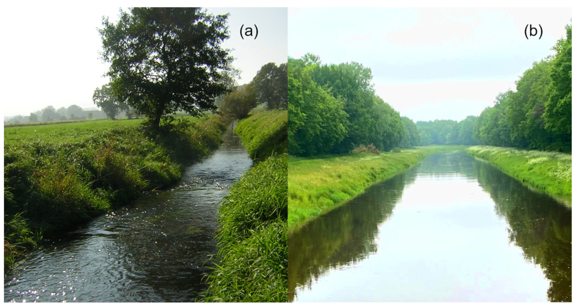
Figure 1). The upper course is assigned to type 6 (“fine material rich, carbonaceous highland streams”,
Figure 2a). It consists of a mix of near-natural river sections and heavily modified river sections. The lower course belongs to type 15 and 15_g (“(large) sand and loam associated lowland rivers”,
Figure 2b) and has been the object of intensive anthropogenic pressure due to intensive river maintenance and regulation of the water course and intensive land use. The results of these pressures are the heavily to completely modified river sections in 92% of the lower course [
35].
The data analyzed was collected from the quality detailed structure mapping of Lower Saxony (“Detailstrukturgütekartierung”) from the Lower Saxony State Agency for Water Management, Coastal and Nature Conservation (NLWKN), which was carried out from March to June 2011 [
35]. The hydromorphological data has been collected according to the Lower Saxony field survey method. Regardless of the water body size, the entire river length was mapped in 100 m sections [
24]. The evaluation of the structural parameters in Germany was carried out on a 7-step scale. To adhere to the official requirements of the WFD, the data were converted from the 7-step scale to a 5-step scale (
Table 1).
For the index-based evaluation, 26 single parameters need to be described via visual inspection. Each single parameter is given an index number between 1 and 7 which describes the current state of this parameter (
Table 1 and
Table S1,
Figure S1). The index numbers of the single parameters are then aggregated to main parameters (MP). These are river development (MP1), longitudinal section (MP2), cross-section (MP3), riverbed structure (MP4), bank structure (MP5) and watercourse environment (MP5). These main parameters can further be aggregated into “riverbed” (river development + longitudinal section + riverbed structure), “bank” (cross-section + bank structure) and “surrounding area” (watercourse environment), describing different compartments of the river. Finally, all main parameters can be summed up in one dimensionless evaluation parameter [
23,
24]. For the evaluation of the functional units, a sound knowledge of the reference river sections is needed. Here, for each main parameter, the functional units are defined which are evaluated according to the reference river sections [
23,
25].
To address the research questions, the river sections of the Hase River belonging to the Lower Saxonian Mountains (river type 6; n = 183 river sections) were compared with the river sections belonging to the Northwest-German Lowlands (river type 15 and 15_g; n = 1253 river sections). The intervening parts of the water course are heavily modified and are, therefore, not suitable for this investigation.
The analysis was based on the index-based evaluation of the six main parameters (MP) river development (MP1), longitudinal section (MP2), cross-section (MP3), riverbed structure (MP4), bank structure (MP5) and watercourse environment (MP6). For both river sections, the frequency of the classes one to five was analyzed and converted into percentages to make the results comparable. In the next step, the difference between the two values was calculated for each main parameter, subtracting the values of the type 6 section from the lowland river (type 15 and 15_g) section. Positive values indicate that this class is more common in the lower course. A negative value means that this class occurs more often in the upper course.
3. Results
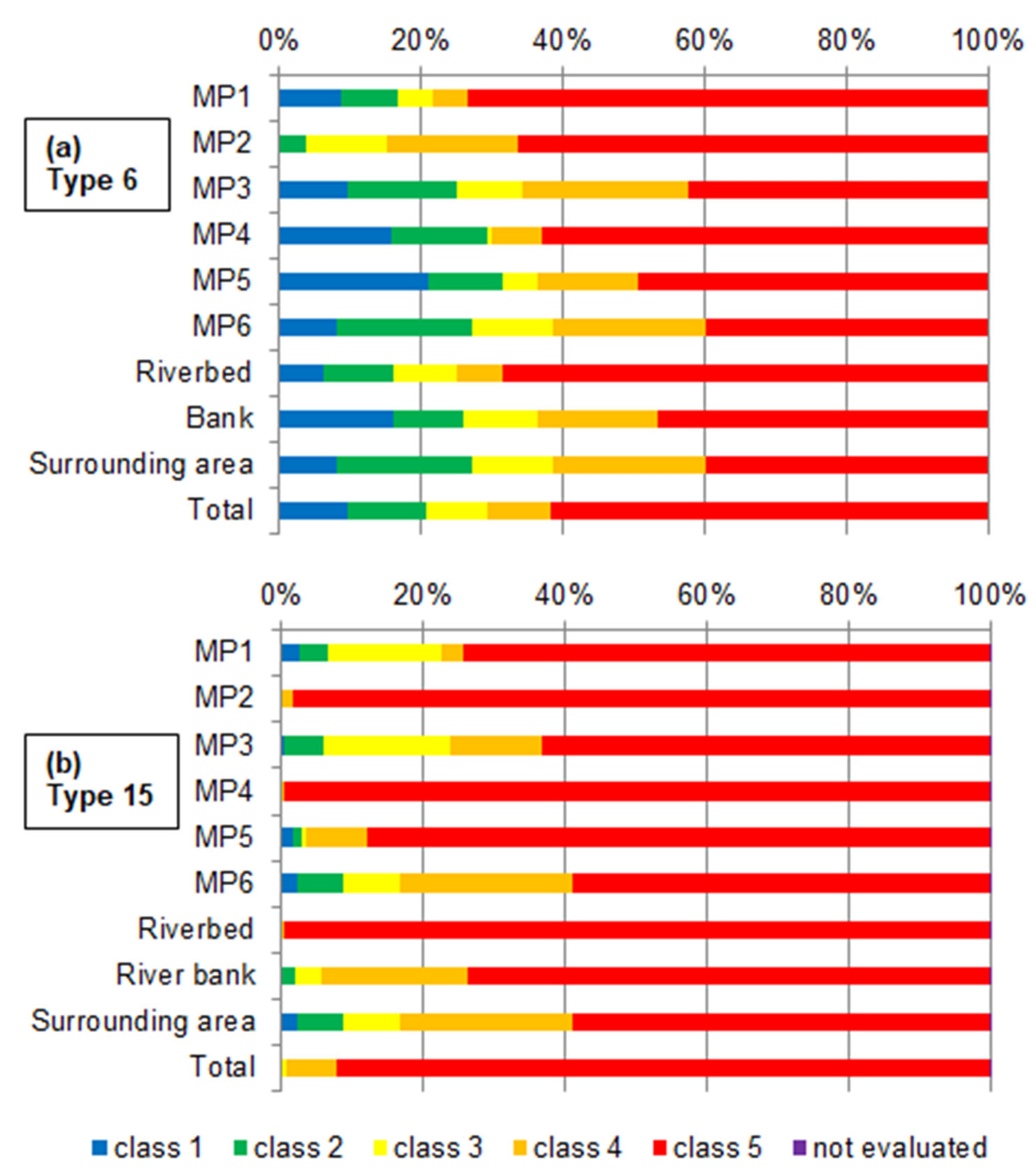
3.1. Current Status of the Upper and the Lower Course
The aim of the water framework directive is to achieve at least a good status of the rivers. In the type 6 river sections of the Hase, only one fifth (21%) of this part was in good or very good hydromorphological condition (
Figure 3a). The results differed considerably between the main parameters. In the longitudinal section (MP2), only 4% of the river sections were in a good condition, zero percent were in a very good condition whereas in the riverbed structure (MP4) and the bank structure (MP5) up to one third of the river sections had already achieved good or very good hydromorphological status.
The evaluation classes 3 and 4 showed at least the potential to achieve a good or very good status in the future. In total, 17% of the river sections showed the potential for hydromorphological improvement, but in the main parameters there was certain variability. In the riverbed structure (MP4), only 8% and in the river development (MP1), only 10% of the river sections showed the potential for improvement.
In the total evaluation of the type 6 part of the Hase River, 62% was in bad hydromorphological condition (class 5). For the main parameters, the situation differed. The watercourse environment (MP6) with 40% and the cross-section (MP3) with 42% showed the lowest proportions of the river section in class 5 condition. In the river development (MP1), most river sections (73%) displayed a bad hydromorphological state.
In the aggregated parameters, riverbed, bank, and surrounding area, the riverbed showed the smallest proportion of good status or the potential to achieve an improvement in the future, with 32%. About 68% remained in bad condition. In the parameter, bank, up to 54% already showed a good status or the potential for improvement, 46% remained in class 5. The parameter, surrounding area, showed the best potential for improvement, with 40% of the river sections remaining in class 5.
In the type 15 and type 15_g river sections of the Hase River, a good or very good hydromorphological status was not achieved in terms of the total evaluation (
Figure 3b). The good status was also not achieved in the main parameters, longitudinal section (MP2) and riverbed structure (MP4). For the other main parameters, good or very good status ranged between 3% in the cross-section (MP5) and 9% in the watercourse environment (MP6).
The potential to achieve a hydromorphological improvement in the future expressed by evaluation classes 3 and 4 was also hardly present for the main parameters longitudinal section (MP2) with 2% and for the riverbed structure (MP4) with 1%. The greatest potential exists for the watercourse environment (MP6) with 32% and for the cross-section (MP3) with 31%. In the lower course of the Hase River, 92% of the river sections were evaluated as class 5 in the total evaluation. Class 5 also dominated in all main parameters but ranged from 59% in the watercourse environment (MP6) up to 99% in the longitudinal section (MP2). In the aggregated parameter riverbed, bank and surrounding area, the riverbed exhibited good status and potential for improvement in only 1% of the river sections. It was followed by the bank and the best status/potential was present in the surrounding area with a total of 41% in classes 1 to 4 and 59% in class 5.
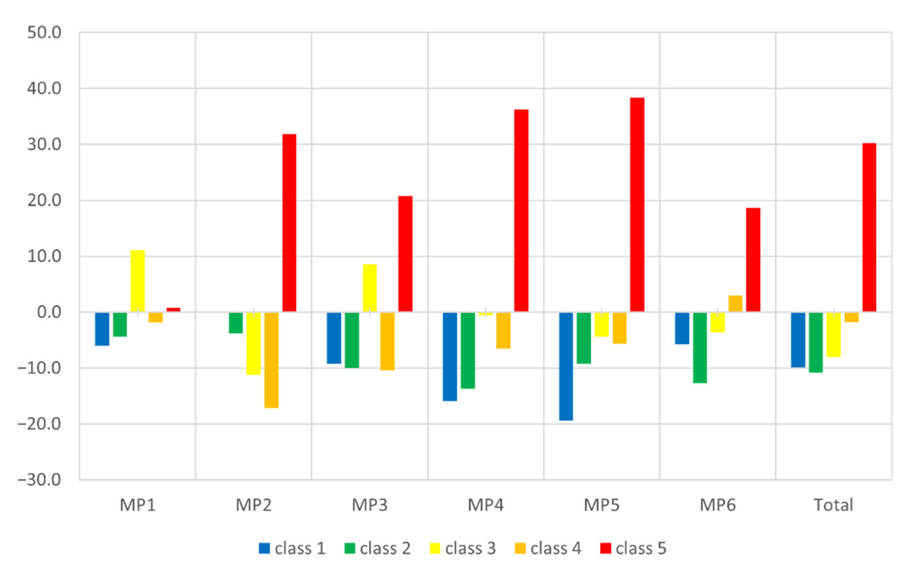
3.2. Comparison between the Upper and the Lower Course
The comparison of the frequency of the evaluation classes between the upper and the lower course showed that in all main parameters and the total evaluation, class 5 occurred more frequently in the lower course than in the upper course. Classes 1 and 2 occurred more frequently in the upper course (
Figure 4).
Class 5 was awarded up to 38% more often in the lower course (MP5; bank structure), and about 30% more often on average. In river development (MP1), the difference between the upper and the lower course in the evaluation class 5 was only minimal with less than 1%. Especially in the riverbed structure (MP4) and the bank structure (MP5), class 1 was assigned significantly more often in the upper course than in the lower course, with 16% and 20%, respectively. For the parameter longitudinal section (MP2), no sections were evaluated as class 1. For river development (MP1) and riverbed structure (MP4), class 3 was found in more river sections in the lower course than in the upper course. For all main parameters besides the watercourse environment (MP6), more sections in the upper course were evaluated as class 4 than in the lower course. In the total evaluation of the Hase River, classes 1 to 4 were found more frequently in the upper course than in the lower course. Class 5, on the other hand, was given more frequently in the lower course than in the upper course. On average, the classes 1, 2 and 3 were assigned 10, 11 and 8% more often in the upper course than in the lower course. The difference in class 4 between the two river sections was only small, with 25% more river sections in the upper part of the watercourse.
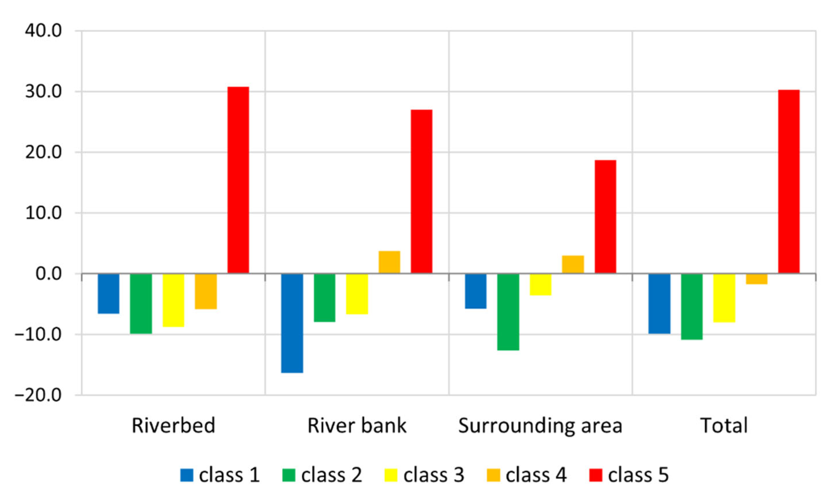
If the evaluation of the main parameters is aggregated into riverbed, bank and surrounding area, the picture is only slightly different (
Figure 5).
Class 5 was given more frequently in all aggregated parameters in the lower course than in the upper course. With 31%, the biggest difference between the lower and the upper course river sections was found in the riverbed. The difference in the bank was only slightly lower (27%). In the surrounding area (MP6), class 5 was still assigned 19% more frequently in the lower course. Classes 1, 2 and 3 occurred more often in the upper course compared to the lowlands. For class 4, a different distribution pattern emerged. In the riverbed and the total evaluation, more river sections were evaluated as class 4 in the upper course. In the bank and the surrounding area, class 4 occurred more frequently in the lower course.
4. Discussion
The results reveal obvious differences between the evaluation results of the upper course and the lower course of the Hase River. In the upper course, 21% was in good or very good condition. Seventeen percent showed the potential for improvement and 62% was in bad condition. In contrast, in the lower course, 92% of the river sections were in bad condition, 8% showed the potential for improvement and no sections were in a good ecological condition. Compared to each other, class 5 was assigned 30% more often in the lowland river sections with the biggest differences in the main parameters longitudinal section (MP2), riverbed structure (MP4) and bank structure (MP5). In river development (MP1), almost no differences were found between the number of class 5 river sections in both ecoregions. The question arises now, to what extent these variations result from actual hydromorphological differences or from artefacts in the evaluation scheme.
The lower course of the Hase River displayed bad quality in the main parameters, longitudinal section (MP2), riverbed structure (MP4) and bank structure (MP5), all contributing to a bad total evaluation of these sections. The bad evaluation of the longitudinal section can probably be explained by the poor actual river conditions. This main parameter consists of the single parameters transverse structures (P2.1), backwater (P2.2), piping (P2.3), cross banks (P2.4), flow diversity (P2.5) and depth variance (P2.6). The single parameters P2.1, P2.2 and P2.3 belong to the so-called “damage structure parameters”. This means that the presence of these characteristics automatically leads to a worse evaluation. If these structures are not present, the parameters are not considered in the assessment. They must not lead to the upgrading of the river assessment [
23,
24]. As there are only a few river sections with transverse structure, backwater or piping, the reason for the bad condition must come from the parameters cross banks, flow diversity and depth variance. The evaluation data showed clear differences of the actual river condition from the reference river condition and explained the bad condition of MP2.
The bad condition in the main parameter bank structure (MP5) can also possibly be attributed to the actual river condition. The lower course of the Hase river has been the object of severe anthropogenic pressures due to intensive river maintenance, regulation of the river course and intensive land use [
35]. This is also reflected in the parameters bank vegetation (5.1) and bank revetment (5.2) in the lower course, with only very few river sections with the natural vegetation and most of the sections revetted.
The other main parameter evaluated very poorly in the lowlands was the riverbed structure (MP4). This main parameter consists of the individual parameters riverbed substrate (P4.1), riverbed revetment (P4.2), substrate diversity (P4.3) and special riverbed structures (P4.4) [
23,
24]. Very often, the predominant riverbed substrate (P4.1) cannot be determined in lowland sections due to depth, insufficient visibility, or inaccessibility of the river. This inevitably means that the parameters riverbed revetment (P4.2), substrate diversity (P4.3) and special riverbed structures (P4.4) cannot be determined either. Thus, the entire main parameter should not be used for the evaluation of the river structure [
23,
24]. In the lower course of the Hase River, the riverbed structure could not be determined in almost 100% of the mapped sections. Nevertheless, the other three parameters were assessed, which actually should not be the case according to the mapping specifications [
23,
24,
37]. Thus, most river sections in the lower course were evaluated as class 5 in the riverbed structure which also contributed to a bad total evaluation. By omitting HP4 from the calculation of the total evaluation, it can be shown that the overall result in the lower course of the Hase River would be better in 32% of the river sections by at least one class if this main parameter was not included in the river structure evaluation.
In addition to the application of the mapping procedures, there were also some discrepancies in the procedure itself for the assessment of the sand-dominated lowland rivers in the LAWA procedure as well as in the Lower Saxony procedure. The criterion for the river structure evaluation is the impairment of the ecological functioning of the watercourse and the floodplain. For this purpose, changes to the structure of this river type in its natural, unimpaired state are recorded. This natural condition is defined by the reference river types. In principle, positive attributes are associated with certain properties of the single parameters in the evaluation procedure. For example, a higher substrate diversity is in general evaluated better than a low substrate diversity [
19,
23,
38]. However, in some cases, a low substrate diversity is the natural condition for a river type such as the sand-dominated lowland rivers. This is already described in the reference river types of Lower Saxony [
39] as well as in the LAWA reference river types [
40]. This characteristic needs to be considered for the evaluation of such rivers [
23]. In this case, a low substrate diversity should be evaluated as class 1 as it represents the natural river condition and not an impairment. For sand-dominated lowland rivers, the natural condition of the single parameter substrate diversity (P4.3) was evaluated quite badly (class 4 in the LAWA scale, class 3 in the WFD scale) even though this represents the natural condition of the river. This leads to a distorted view of the actual river condition in the sand-dominated rivers of the lowlands.
Although there is almost no difference in the percentage of class 5 river sections in the river development (MP1) between the upper and the lower courses, this main parameter is in a bad condition in the lower course (75% class 5 river sections). Especially regarding this main parameter, there was an interesting inconsistency in the Lower Saxony assessment method. The ecological status largely depends on how the hydromorphological assessment methods are designed and used [
41,
42]. To ensure a uniform mapping procedure in Germany, LAWA has made recommendations for the mapping of the river structure of small to medium-sized watercourses and of medium-sized to large watercourses [
22,
23,
37]. LAWA specifies different lengths for the mapping sections depending on the width of the watercourse, as some structural parameters are dependent on the size of the watercourse. Therefore, the regular section length for creeks is 100 m, while in small- and medium-sized rivers the section length varies from 200 m to 1000 m [
20,
37]. Today, LAWA recommends section lengths of 100 m for streams narrower than 5 m, 200 m for rivers between 5 and 10 m and 500 m for rivers between 10 and 20 m [
23]. Since these are only recommendations and not binding, the Federal States have adopted them quite differently into their own mapping procedures. Several Federal States, including Baden-Württemberg, Hessen, North Rhine-Westphalia, Mecklenburg-Western Pomerania, and Schleswig-Holstein, have adopted different lengths of river sections in their mapping systems [
43,
44,
45,
46,
47]. Other Federal States, such as Lower Saxony and Bavaria, use a uniform section length of 100 m regardless of the water body size [
24,
47].
There are also differences in the evaluation and assessment of the water body structures. While in Lower Saxony, all single parameters are recorded individually for each section, in Bavaria, some parameters (course curvature, depth and width variability, flow and substrate diversity) are recorded for several sections at the same time. The evaluation is, therefore, carried out in section blocks, as these parameters cannot be properly represented in such small sections [
48].
The characteristics of most of the parameters recorded depend on the natural conditions and should be assessed according to the regionally specific reference river sections. The natural formation of some of the structures of a watercourse depends to a considerable extent on the size of the watercourse, such as the parameters of longitudinal banks (P1.3), special course structures (P1.4) and cross banks (P2.4). For these three parameters, a more frequent occurrence is associated with a good evaluation class. However, the frequency must also be interpolated to the width and the type of the watercourse. In principle, these structures are expected to be more frequent in small upland and hilly waters than in the lowland waters [
37]. If short sections (e.g., 100 m) are mapped in the lowlands, these particular structures occur less frequently than in longer sections (e.g., 500 m). The frequency of the occurrence of the structures is, therefore, statistically underestimated, and lowland rivers tend to be evaluated worse with this mapping system [
12]. The evaluation of larger, contiguous stretches of the river, e.g., in section blocks as in Bavaria, could lead to an upgrading of some main parameters such as the longitudinal banks (P1.3), special course structures (P1.4) and cross banks (P2.4). An upgrade in these parameters could also lead to an upgrade of the total evaluation class in these river sections.
Overall, the very distinctive differences between the evaluation of the Hase in the uplands and in the lowlands and the conditions described above, allow the reasonable assumption that the evaluation in the lower course only partially reflects the reality and the actual condition of the watercourse. This leads to the conclusion that the mapping procedure of Lower Saxony did not sufficiently address the reference river type of the sand-dominated lowland rivers. Since the river type changes in the course of the Hase, the mapping procedures and its specifications must also be adapted to the river size and the river type. This was obviously not sufficiently taken into account.
In order to avoid such discrepancies between the evaluation of different river types in the future, some recommendations can be made. First, the consistent implementation of the LAWA mapping procedure in all Federal States would certainly be beneficial for the river structure assessment, particularly regarding the section lengths. Then, a revision of the index numbers of the riverbed structure (MP4) for sand-dominated lowland rivers in the LAWA mapping procedure and the Lower Saxony procedure could also help in their proper evaluation. Finally, it would also be helpful if such transitions between the river types were pointed out more clearly during the mapping process. Another alternative would be the development of mapping sheets for every river type (or at least, each ecoregion). Other authors also report that there are bottlenecks in the implementation of the WFD [
49]. Carvalho et al. [
50], for example, stated that management and assessment need to be linked in the future to achieve good ecological status and that water resource protection needs to be integrated and mainstreamed with other sectors to achieve the WDF goals. However, prior to these further developments the basic monitoring of the ecological water quality such as the mapping procedures of the hydrological assessment need to be revised and harmonized (at least) at a national level to ensure that reliable and comparable data is available to address these higher targets.


