
A Knowledge and Evaluation Model to Support the Conservation of Abandoned Historical Centres in Inner Areas


Department of Civil Engineering and Architecture, University of Catania, 95124 Catania, Italy
*
Author to whom correspondence should be addressed.
Heritage 2024, 7(3), 1618-1664; https://doi.org/10.3390/heritage7030077
Submission received: 11 February 2024
/
Revised: 5 March 2024
/
Accepted: 6 March 2024
/
Published: 14 March 2024
Abstract
:The planning of interventions aimed at preserving the built heritage of inner areas is a complex process due to the fragility of these contexts. It should stem from adequate knowledge to support the recognition of qualities, resources, and potentials, and the reinterpretation of residual values. From the perspective of an axiological approach to the built heritage, it is possible to foster the resemantization of such values based on a rigorous cognitive model. This research proposed a cognitive model of the built heritage of the historic neighbourhood of Granfonte in Leonforte (Enna). The knowledge model, developed in Excel, has a hierarchical type of structure characterized by domain, classes, properties, and the attribution of values to properties. The approach makes it possible to execute queries that arise from specific relationships between classes. In this study, we developed both simple queries to measure the percentages of certain characteristics of the building units and complex queries for the estimation of aggregate indices to define the degree of transformation and loss of integrity and degradation of the building units or to identify those most exposed to the risk of ruination and contagion. The proposed model can be framed within the framework of ontologies supporting structured heritage knowledge.
1. Introduction
The issue of historical centres has been debated extensively over the last century, but several recent studies highlight the need to review and deepen the topic also in relation to the new and more accelerated processes of change in the life of cities and the current dynamics that appear to have changed somewhat since the last century [1,2]. Despite the recognised importance of the historical areas of our cities within a well-established culture, a multitude of phenomena threaten their survival. Among these, depopulation represents “the most visible element” [3] (p. 8). The issue is worth considering from within the framework of the recent renewed attention to the territorial specificities and heterogeneities [4] within which the marginalised conditions of many historic centres are placed.
Thus, the problem of their abandonment and decay is inevitably linked to the complex issue of inland areas: if, above all, the processes of tertiarization and gentrification threaten the centres with a leading economic role or strong tourist attractiveness, the progressive decline due to the state of underutilisation and the general loss of attractiveness of the oldest part is widespread in disadvantaged territorial and urban contexts affected by an economic and demographic crisis.
The need to return to the subject of historical centres and update knowledge of them with a new reflection on the current situation appears to be emerging. In fact, despite the flowering of studies on the theme of inland areas stimulated in Italy by the National Strategy of Inner Areas, [5], the state of knowledge on the level of involvement of the historic urban heritage and the dynamics at the scale of the built environment remains fragmentary and lacking [6].
The identification of development strategies to strengthen marginal and weak economies is part of EU structural policies aimed at enhancing economic, social, and territorial cohesion [7]. In the Italian experience, these actions have so far provided for the activation of 72 internal areas and others in the process of being activated [8]. They address the identification of a new mix of functions and activities, the strengthening of infrastructures, and the identification of specific funding to implement these transformations. Italian policies are thus in line with the most recent European orientations. In this regard, the example of France is also significant, where the last decade has witnessed a proliferation of national programmes aimed at lifting territorial imbalances [9,10] effectively described by the expression “diagonale du vide” [11].
Some lines of research emphasise the need to structure an accurate system of knowledge of current dynamics and to take action to safeguard historic centres through the drafting of preventive and risk mitigation tools and to respond to critical issues [3,12].
The question invokes two orders of complexity. The first appears closely connected to the nature of the object of investigation. As a part of the city, the historical centre is a living organism, a unique and even multiple and varied system, declinable on several scales and examinable under several aspects. By its very nature and tradition, the study of the historical centre represents a crossroads of a multiplicity of knowledge and competencies. This recognition implies a multi-scalar study approach and an unavoidable multi-perspective and multi-disciplinary openness on the topic [13].
The intrinsic complexity of the historic city increases with the processes of abandonment and decay. Therefore, the second order of complexity is related to the loss of inhabitants and the effects this causes on the built environment.
The difficulty of taking a census of the dynamics at work on a territorial scale, quantifying the extent of the phenomenon of abandonment and the level of involvement of historic areas, and assessing the concrete effects on heritage is well established [14]. The abandonment of historical centres is a complex and multiform phenomenon, not easily measurable because it involves a system of relational values between individuals, communities, and places [15].
In its partial manifestation, abandonment has considerable problematic aspects [16].
The planning interventions on a local scale to support the development of the identified strategies should first and foremost promote the revival of local economies. But this should also protect the identity and culture of contexts [17,18,19,20] that, in some cases, appear exposed to the risk of uncontrolled or summarily assessed transformations. In the face of an emergency decline, such actions could permanently distort the nature of these places. The need to intervene does not mean intervening at all costs, but it does mean reinterpreting the residual values of these contexts in new and more modern ways [21].
Within the framework of the epistemology of complexity, the historical centres—including those in inland areas—represent open complex systems. As such, they can become dissipative structures, i.e., identified in a thermodynamic perspective, proposed by Elia Prigogine [22,23]. According to Rizzo [24], these structures, if crossed by a flow of matter, energy, and information, can find a new neg-entropic order, which is the only one capable of promoting a reconversion of the entropic process to which the heritage in these areas is subject.
The flow of information can activate that new order capable of creating new value for the historical centres of inland areas. The process of identifying this information flow capable of activating this mechanism must “in(form)” the historical centre: in other words, it must be capable of giving it a new shape. The flow can give a new form if the information flows from structured knowledge developed from an axiological perspective capable of grasping the current state of values and supporting their re-interpretation [25].
The cognitive model must be able to provide a set of information that can support a planning model hinged on the peculiar values of these complex organisms such as historic centres [26,27,28,29,30,31,32,33,34,35,36]. The programming process of interventions in this perspective is not just a forecast of interventions but can be identified as the way to make the most of these contexts with actions that spring from their values or dis-values, according to a path of resemantization [37,38].
Initiating a process of resemantization concerning the linguistic nature of the architectural phenomenon is tantamount to detecting and interpreting the meaning of the words or individual elements that characterise the built heritage and the set of words or phrases that represent the individual heritage units or urban aggregates. This process, regarding the grammatical nature of the evaluation of project quality, can be identified on the basis of Bloomfield’s American structuralism [39]. According to this thinking, grammar is how forms endowed with meaning, that is, semantic elements or signs, are arranged. If free, these give rise to syntactic constructions (syntagmas, propositions, and utterances) and are based on the function of the elements regardless of their form; if bound, they give rise to morphological constructions and depend on the form of the elements and their aptitude to change.
In this perspective, semantic elements or signs can be considered free when they are capable of having meaning irrespective of context, while they are bound when they take meaning from the context by modifying themselves to fit and join the other elements that constitute it [40]. Regarding this latter meaning, we must seek the meaning of intervention programming. Nevertheless, in the perspective of programming actions aimed at the protection, conservation, and valorisation of historical centres [41,42,43,44,45,46,47,48]—and especially those falling in marginal areas—the semantic elements are free and bound. In this regard, a trans-disciplinary approach stemming from the integration of several disciplines such as “Restoration” and “Real estate Appraisal and Evaluation” can support the process of resemanticizing the built heritage of historic centres. The former primarily addresses free meanings and the latter constrained meanings, but overall, both can work to integrate the dual nature of such signs.
Structured knowledge developed from an integrated disciplinary perspective can support the development of such a process.
To this end, this research proposes a cognitive model, developed in Excel, of the built heritage of the historic centres on the verge of abandonment in internal instrumental areas to promote this process of instrumental resemantization for the programming of the interventions identified in the context of the strategies for the specific areas. In particular, the research proposes an initial experimentation of the cognitive model of the built heritage of the historic district of Granfonte in Leonforte (Enna).
The paper is organized into the following sections:
- Section 2 illustrates the state of the art in the framework of new knowledge and evaluation methodologies of the built heritage;
- Section 3 describes the application area of the model: the case study of the Granfonte Neighbourhood in Leonforte in the Sicilian hinterland;
- Section 4 illustrates the methodology adopted;
- Section 5 presents the model and reports the first results of the queries;
- Section 6 explains the significance of the findings and their implications for the field of knowledge and gives suggestions for future work;
- Section 7 summarizes the main research findings.
2. New Perspectives in Heritage Knowledge and Valuation
In line with the most recent theoretical developments, knowledge is to be understood as a process aimed not only at the realisation of a quality project, but in a broader vision, has decisive role for management, updating, and monitoring. These phases are now recognised as being of considerable importance in the framework of actions to protect historical centres [49,50,51,52,53,54]. Dealing with the complexity of a historical city centre implies a necessary preliminary reflection on the tools and approaches to knowledge, with the requirement of multi-scalarity—the ability to grasp the relationships between the individual building units and the urban organism—and the management of significant quantities of data and information.
The topic intersects with the opportunities of IT tools and digital methods in the conservation process, from the documentation and cataloguing phase to applications in the project and building site context [55]. The most recent experiences reaffirm “the positive and driving role” [6] (p. 9) that IT tools can play for protection and enhancement. In the field of restoration, recent strands of research tend to elaborate methodologies aimed at structuring the processes of documentation and knowledge, supporting the acquisition, standardisation, and management of data, and evaluating the possibilities of interaction and interoperability between different software, systems, and databases.
The subject of digitisation is related to the definition and use of ontologies, which enable the conceptualisation of a domain. The structure of the ontology is based on entities, which represent objects and concepts, which in turn are defined by specific properties and relations with other entities [56,57,58,59,60,61,62,63,64,65,66,67,68,69,70,71]. The construction of a conceptual model also poses the problem of knowledge representation through semantic formalisation and the definition of shared vocabularies. As appropriately pointed out, conservation-oriented experiments have highlighted the difficulties of defining and translating the complex reality of existing heritage on a semantic and metalinguistic level.
In the field of cultural heritage, the formal ontology called the CIDOC Conceptual Reference Model (CRM), developed by the International Council of Museums to support the process of documenting and exchanging information on cultural heritage, has emerged as a reference in the international arena [72].
Moving into the field of architectural heritage, the need to extend the applicability of modelling to the conservation of historical architecture has led to the definition of an ontology-based model [73] aimed at formalising all stages of the knowledge process.
These more specific applications also explore the possibilities of implementation in a digital environment to interface not only with GIS systems, but especially the BIM environment [74,75,76,77,78]; however, the use of these applications in the field of restoration remains problematic [79].
The difficulties lie in the unique character of historical architecture and the complex approach that is required to investigate it: the intention to adapt the existing process to a standardisation process runs the risk of simplifications and reductive visions of the reality and resources of historical architecture [80].
As part of the latest developments for the built heritage, recent research conducted by the Institute for Construction Technology (CNR) is aimed at defining an ontology to support the conservation process of the architecture of minor historic centres, to apply the formalisation of a model to BIM systems [49].
Finally, in the broad framework of experiences oriented to the digital transaction for protection, the new Risk Map of the Italian Ministry of Culture for historical centres deserves special attention, as it allowed the already existing territorial information system to become enriched with new functions, which are necessary to structure the knowledge of historical centres at different scales [81].
Since the first experiments, the Risk Map system has responded to the primary objective of “defining the risk of loss to which heritage is subject” [82] (p. 65). The recent elaborations support the process of cataloguing and managing historic centres by providing a significant contribution not only concerning digitisation aimed at sustaining the conservation activities of the built heritage but also encouraging the dissemination of information technology in local administrations [6]. The result offered is undoubtedly considerable as it responds to the need—which has now become urgent and impressionable—to build an information base of the widespread heritage to support its knowledge and protection; however, this system is not yet directly aimed at the operational phase through the planning of possible interventions.
The use of IT tools can support the conservation of declining centres for managing complex phenomena and defining appropriate courses of action. Nevertheless, it is worth emphasising that the organisation of such tools “is not a neutral act of a strictly engineering nature but is determined based on the establishment of a precise hierarchy of values” [83] (p. 1543).
Since data are never neutral, such instruments supporting cognitive processes need to be fully understood and consciously governed. In the field of conservation, the management of data can have tangible repercussions on the entire process, from knowledge to interpretation to concrete intervention in the built environment.
In the literature, the issue of evaluating the built heritage of historic centres concerns studies aimed at identifying actions for their conservation, [84,85,86,87,88,89,90] reuse [91,92,93,94,95,96,97,98,99,100,101,102,103,104,105], the assessment of their vulnerability, and the integration of measures to reduce their seismic risk [106,107,108,109,110,111,112,113,114,115,116,117,118,119,120,121,122,123,124,125,126,127].
3. The Case Study: The Granfonte Neighbourhood in Leonforte
Our research applies the model to a small historical centre located in the inland areas of the Sicilian region. With its condition of insularity and the massive migratory phenomena that have affected it throughout history, Sicily represents a context of great interest for exploring the phenomenon of the abandonment of historical areas.
The chosen case study is the historic district of Granfonte in Leonforte, in the metropolitan area of Enna. With a census population of 12,513 in 2021 [128], Leonforte falls within the range of the region’s small to medium-sized municipalities. Referring back to the classification recently proposed in the national context on the types of dynamics at work in Italy’s historic centres, [3] Leonforte can be traced back to the case of small and medium-sized cities in crisis that have a historic centre in the process of being abandoned. The inexorable demographic haemorrhage that has affected the city since the Second World War represents a condition common to a good part of inland Sicily between the provinces of Enna, Agrigento, and Caltanissetta, and caused by the crisis of the rural economy of the hinterland [129]. In the case of Leonforte, this process, combined with other factors related to political choices [130], has had significant repercussions on the fate of the historic area. In this context, the Granfonte neighbourhood, corresponding to the oldest built-up urban area, has undergone a progressive process of marginalisation. Despite its strong heritage and landscape values, today this neighbourhood is perceived as a discarded place and is affected by a worrying condition of decay due to the increasing abandonment of the ancient dwellings.
Preliminary Studies
The study of the Granfonte district is part of a broader research project included in the departmental project ‘Conservation of settlements and sites of cultural interest between abandonment and overcrowding’, led by the scientists Caterina Carocci and Maria Rosaria Vitale.
Following an initial reconnaissance of bibliographic, cartographic, and photographic sources, the fieldwork and the expeditious survey phases made it possible to develop the knowledge of the Granfonte neighbourhood. The reading aimed at highlighting the urban and building characteristics and was conducted at the urban scale of the building aggregate and the buildings. This preliminary study made it possible to define the map of the neighbourhood, and to identify the aggregates and building units that compose the building fabric [131].
Thus, it was possible to deepen the study of the main building types, the aggregative modalities linked to urban morphology, and the local constructive technique.
The Granfonte neighbourhood represents the oldest built-up urban area and extends along the southern edge of the town, on the slopes of Mount Cernigliere. The preliminary study of the historical maps showed how the urban plot had overall preserved its 19th-century aspect, probably not significantly different from that of the first settlement. The small-sized historical fabric and the essentiality of the buildings’ functional configuration highlight the vernacular character of the settlement [132]. Indeed, the building is based on the principles of optimising available space and resources using local materials.
The typical traditional architecture therefore presents rather modest characters and simple volumes that are the result of the local building culture.
A peculiar characteristic of the Granfonte neighbourhood derives from the exploitation of the orographic conditions: the buildings are built on banks of rock outcrops following an arrangement of the aggregates generally parallel to the contour lines. The presence of the rock thus conditions the characterisation of the building type, the construction solutions, and the overall layout of the buildings. The typological study showed the extent to which the built environment is always strongly related to the natural slope. This has therefore made it possible to identify the two main building types: the on-slope type, and the type with an external staircase (profferlo) [131,133].
The first field surveys immediately revealed the neighbourhood’s state of decay and abandonment (Figure 1). Through a closer reading of the historical fabric, a rather diversified picture of the state of use and preservation of the built environment emerged. In fact, in the neighbourhood, there are buildings in good condition and still inhabited, abandoned buildings, and others in a state of ruin [16]. Moreover, while some buildings have retained the architectural qualities ascribable to a configuration close to the original, others have undergone heavier transformations that have sometimes distorted their vernacular character.
These analyses have thus highlighted the relevance of the case study. Indeed, the neighbourhood presents itself as a very fragmented and diverse urban context, characterised by peculiar settlement conditions and affected by the contradictory effects of abandonment. These conditions profile several challenges for the definition of a knowledge and evaluation model.
4. Methods
The definition of a cognitive model for the building heritage of the Granfonte neighbourhood is part of a line of research developed in the field of restoration, in which the Risk Map (RM), as a new system for the cataloguing and management of historic centres, currently represents a best practice. Asset cataloguing is instrumental in establishing a knowledge base to support more efficient management of protection and valorisation processes. The proposal of a new cognitive model developed within the framework of two disciplines, that of “Restoration” and that of “Real estate Appraisal and Evaluation”, starts from the analysis of the Risk Map for Historical Centres and attempts to define information support with strong operational potential, i.e., capable of being directly integrated into an intervention planning model and a DSS.
Following the first phase of the study conducted with restoration methodologies and aimed at highlighting the special characteristics of the Granfonte neighbourhood, the model was elaborated with the help of the valuation approaches of real estate appraisal and evaluation.
The methodology adopted consists of three phases (Figure 2):
- The construction of the model;
- The data collection model;
- The interrogation of the model.
4.1. Model Structuring
We aim to define a multi-purpose tool, capable not only of describing and interpreting the characteristics of the built heritage but also of proposing an initial assessment to support future interventions.
The elaboration of the Risk Map system for historic town centres is based on a systematic filing at multiple levels. The aim is to fill a gap in the knowledge of Italy’s historical centres, producing documentation on their characteristics and state of conservation and transformation. A very interesting aspect of the map concerns the estimation of vulnerability and transformation indices, calculated based on complex algorithms, capable of providing statistical and interpretative indicators of the actual condition of the built environment. The Risk Map thus provides a significant contribution not only to the concrete possibilities of a systematic census of historical centres, but also offers significant openings to new ways of dealing with the issue of centres undergoing depopulation. However, since the drawing up of the index card is intended to be used for the entirety of historic centres and is independent of the phenomena affecting them, it seemed appropriate to reflect on the possibility of an integration that would be able to consider the aspects linked to the specificity and complexity of abandonment and the types of risks it may generate.
The design of our model followed a deductive method: this involves systematising the results of the knowledge of the neighbourhood with the structure of the Risk Map datasheets for the protection of historic centres, re-using some of the items in these sheets, integrating others, and introducing new indicators to consider certain specificities of the historic area under study.
In detail, the construction of the model was based on the consultation of the Field Sheet of the Urban-Unit-Aggregate, the Urban-Unit-Pointly Building, and the Building Front, together with the related Compilation Rules [134,135,136].
The sheet for the Building Unit had not yet been published at the time the model was drawn up [137].
Integration with the Risk Map system and with further information is instrumental for an in-depth characterisation of the built system.
The proposed cognitive model has a hierarchical structure, as shown in the Figure 3.
To be able to become an operational tool, the model is aimed at providing a cognitive input capable of detecting the peculiar characteristics of the i-th building units of the historic centre.
The structure of the model is hierarchical and consists of five levels. The first level defines the domain or scope of the model—i.e., the analyses on the built heritage ; the second level represents the classes—i.e., the building components or characteristics of the i-th building units ; the third level represents the properties of the classes ; the fourth level further specifies the properties in a second level , which in some cases is instrumental in improving the information content on ; the fifth level is instrumental in attributing value to the properties using a ), a label ) or the corresponding unit of measurement .
The model proposed in this section was developed in a Microsoft Excel environment and is aimed at facilitating the creation of a model to support heritage protection and enhancement.
4.2. Data Collection Model
The database to support the characterisation of the cognitive model for the built heritage of the historic neighbourhood of Granfonte is constructed on the basis of information gathered through the reading of the historical fabric and site investigations, supported by the comparison with documentary, cartographic, and photographic sources.
The compilation cross-references the critical reading of the historical cadastre of 1878 with current maps and aerial photographs.
Moreover, it is based both on cadastral plans and surveys, where they exist, and on an expeditious analysis, mainly from the outside, which is systematic and extended to the entire neighbourhood, for a total of 294 surveyed units.
For some units, the lack of documentary material on the internal characteristics required, where possible, the use of some hypothetical data, and in the most uncertain cases, the extension of the compilation of some fields.
In detail, the sources consulted during the compilation consisted of the materials listed below:
- Historical cadastre of 1878 [138];
- Basic planimetry of the neighbourhood drawn up by the Restoration Research Unit of the University of Catania, based on expeditious and topographic surveys [133];
- Cadastral plans of some building units [139];
- Surveys of some of the neighbourhood aggregates produced and refined during the elaboration of a dissertation [140] and in the Restoration Laboratory courses at the University of Catania, A.Y. 2021/2022, 2020/2021, 2021/2022, conducted by professors Caterina Carocci, Chiara Circo, and Maria Rosaria Vitale;
- Recent studies on the urban and building characteristics of the neighbourhood [16];
- Census of ruins and their state of decay in the neighbourhood [16];
- Data from direct observation of the built environment.
4.3. Query Model
The knowledge model identifies the basic information content related to the built heritage of the Granfonte neighbourhood.
The cvs-format database of the properties from the classes and their evaluations can be supported by using QGis for the creation of thematic maps, and thus can help to do the spatial analysis of building units on an urban scale.
The knowledge model can be further queried based on specific queries that can extract information on building units from the database.
Since queries identify specific relationships between property valuations from different classes, different systems of properties and relationships can be analysed and identified, and thus different queries can be developed.
Queries can be simple instructions to calculate percentages of with specific characteristics to quantify the level of certain properties of particular interest. Queries can also be complex if they are aimed at defining the relationship system between properties. The latter may be developed based on specific statistical or multi-criteria analyses. They may be processed in the database Excel file itself or with the aid of specific software, the results of which are used to develop database queries.
Simple queries can be represented by relations of the following type (Equation (1)):
This query represents the number of with a given Score for a property compared to the total number of .
Complex queries may allow an aggregate index to be estimated to measure the state of decay of buildings—. Furthermore, in relation to the contradictory co-presence of abandonment and transformation phenomena detected in the neighbourhood—a condition detectable in other declining contexts [143]—the possibility of estimating the degree of transformation and loss of integrity in order to highlight the permanent and authentic features, the peculiarities, and the historical–architectural qualities of the built environment is of interest. In this regard, a query could estimate an aggregate index of transformation and loss of integrity—. Other queries may be developed to characterise specific phenomena, which in most cases are the result of statistical analyses, for example a multivariate regression model or a PCA (Principal Component Analysis).
The properties and relationship system for estimating an aggregate index to measure the decay and transformation state of can be formalised based on the following process:
- Identification of the properties from the class for aggregate index estimation or ;
- Estimation of an aggregate index based on Equation (2) [21]:where represents the values of the j-th property of the i-th , and represents the relative weights.
The weight system was identified using the Entropy Weight Method (EWM) [144].
- Aggregate index normalisation;
- Estimation of aggregate index quartiles;
- Classification of based on aggregate index quartiles.
The results of all queries can be exported from Excel in cvs format and thus, with the help of QGis, can be used to generate spatial thematic maps.
5. Results
The experimentation on the case study of the Granfonte neighbourhood in Leonforte made it possible to define a model for the knowledge and evaluation of the built heritage. The structure of the model and the first results derived from the interrogation of the compiled database are presented below.
The presentation of the results is structured according to the methodological approach and the organisation of the model. The results are organised in two subsections: the first one presents the model and describes its entire structure; the second one shows the results related to the query of the model.
5.1. Model Presentation
From a methodological point of view, the study attempts to coordinate the descriptive level with the interpretative and evaluative one, aimed at the attribution of value judgments concerning the recognition of historical–architectural and cultural values. The model thus represents a multi-purpose tool capable not only of systematising knowledge about the historic district but also of interpreting the results and orienting the decision-making phase by supporting future planning at the urban scale. In this sense, it is an inter-scalar tool, capable of acting as an intermediate address between urban planning and architectural design.
The structure of the model as defined above is hierarchical (Appendix A shows the complete hierarchy). This structure is characterised by five levels described below.
5.1.1. Analysis Domain
The first level identifies seven domains of analysis that relate both to the general configuration of the building and to its architectural and construction characteristics, namely: —identification data and geolocation, —typological analysis, —dimensional analysis, —building use analysis, —accessibility analysis, —building front analysis, —building components analysis, —finishes and fixtures analysis, and —interior typological characteristics analysis (Figure 4).
5.1.2. Classes
The second level identifies the classes that characterise the analysis domain, i.e., building components or building characteristics , as shown in the Figure 4, namely: —identification data and geolocation, —typological characteristics, —building dimensions, —use, —accessibility, —facade layout, —elevation walls, —floors, —internal vertical connections, —roofs, —openings, —protruding volumes/elements, —exterior cladding and finishes, —facade and openings decoration, —external fixtures, —historical furnishings, and —internal partitions.
5.1.3. Properties
The third level identifies the properties of building component classes and building characteristics:
- For the class —identification data and geolocation, we selected the following properties: —identification —building unit, —identification —building aggregate, —cadastral identification—parcel number, —longitude and —latitude.
- For the class —typological characteristics, we selected the following properties: —period of construction, —building type, layout related to the aggregate, — , layout related to the slope proportions, position related to the slope, and —ground level junction. These properties consider the settlement characteristics that, in the case of the Granfonte district, are always strongly interrelated with the orographic conditions. In fact, the coexistence of rock and built-up areas form a constant in the settlement and a qualifying element of its architecture. The natural gradient conditions the overall layout and distribution of the houses.Class —typological characteristics also include the properties —plan changes and —elevation changes. These properties make diachronic mutations explicit, i.e., the processes of mutation of the type [145]. These transformations can be detected through direct observation or can be deduced through a comparative analysis between the historical cadastre and the current situation. Consulting the cadastral plans, where available, also made it possible to assess the level of transformation of the interior layout. Also, part of this class are the properties —building replacement and —ruination. The latter notes an ongoing process of ruination.
- For the class —building dimensions, we selected the following properties: —front 1 width (main front), —front 2 width, —front 3 width, —front 4 width, —front 1 height, —front 2 height, —front 3 height, —front 4 height, —depth, —no. of floors (front 1), —no. of ground level entrances (front 1), —no. of profferlo entrances (front 1), —surface area (front 1), —no. of floors (front 2), —no. of ground level entrances (front 2), —no. of profferlo entrances (front 2), —surface area (front 2), —no. of floors (front 3), —n. of ground level entrances (front 3), —no. of profferlo entrances (front 3), —surface area (front 3), —no. of floors (front 4), —no. of ground level entrances (front 4), —no. of profferlo entrances (front 4), —surface area (front 4), —no. of floors, —area per floor (ground floor), —area per floor (first floor), —area per floor (second floor), —other floors area, —height per floor (ground floor)—height per floor (fist floor), —height per floor (second floor), —height per floor (third floor), —other floors height, and —volume. These properties describe the geometric–dimensional characteristics of the building unit. However, it is worth dwelling on the properties relating to the accesses per front. In the study of building typology, the characterisation of the accesses represents essential data. In the case of the Granfonte district, in which the built-up area is characterised by its close relationship with the natural slope, it is necessary to consider the fact that the course of the terrain influences the arrangement of the house entrances. Houses are frequently characterised by two different entrances, one on the uphill side and the other on the downhill side. In cases where the extent of the height difference and its course prevents access, there is a profferlo to reach the first floor of the dwelling.
- For the class —use, we selected the following properties: —state of use, —building occupancy (ground floor), —building occupancy (first floor), —building occupancy (second floor), —building occupancy (third floor), and —building occupancy (fourth floor).
- For the class —accessibility, we selected only one property —accessibility.
- For the class —facade layout, we selected the following properties relating to the geometric–co-dimensional characteristics of openings on the building face: —no. of windows front 1, —no. of doors front 1, —no. of garage/warehouse doors front 1, —no. of small windows front 1, —no. of holes front 1, —no. of windows front 2, —no. of doors front 2, —no. of garage/warehouse doors front 2, —no. of small windows front 2, —no. of holes front 2, —no. of windows front 3, —no. of doors front 3, —no. of garage/warehouse doors front 3, —no. of small windows front 3, —no. of holes front 3, —no. of windows front 4, —no. of doors front 4, —no. of garage/warehouse doors front 4, —no. of small windows front 4, —no. of holes front 4, —windowed opening area front 1, —windowed opening area front 2, —windowed opening area front 3, —windowed opening area front 4, —window-to-wall ratio front 1, —window-to-wall ratio front 2, —window-to-wall ratio front 3, —window-to-wall ratio front 4, —opening arrangement front 1, —opening arrangement front 2, —opening arrangement front 3, and —opening arrangement front 4.
- For the class —elevation walls, we selected the following properties: —load-bearing masonry, —reinforced concrete masonry, —no. of load-bearing walls, —no. of shared walls with contiguous , —no. of floors contiguous to ruins, and —level of contiguity to ruins.These properties define the traditional construction and transformation system; they consider the type of interaction between contiguous units and the possible contiguity to a ruin. In fact, the conspicuous presence of ruins in the neighbourhood has an impact on the aggregate by influencing the behaviour of contiguous units.Class —elevation walls also includes conservation properties according to types of degradation and instability that are taken from the Risk Map sheets [49].We therefore identified —surface degradation, —masonry slackening, —non-structural cracks, —through-wall crack, —out of plumb, —expelled wall surface (cornerstones, wall covers), —material disintegration, —walls collapse, —wall refurbishment, —cornerstone refurbishment, and —no. of demolished floors. It was necessary to introduce this last property because of the numerous demolition actions undertaken in the neighbourhood.
- For the class —floors, we selected properties for all detectable building systems in the neighbourhood: —wooden floor, —metal floor (with girder-slabs), — einforced concrete floor, —wooden loft, —wooden mezzanine, —reinforced concrete mezzanine, —metal mezzanine (with girder-slabs), and —vault.Also included in class —floors are properties relating to constructional vulnerabilities and the state of preservation of horizontal structures: —connection to load-bearing walls, —floor deformations, —breaking of parts, and —floor collapse.
- For the class —internal vertical connections, in analogy to the previous classes, we selected the properties relating to vertical connection systems found in the neighbourhood: —staircase in the barrel vault, —staircase in the barrel vault, —steps carved into the rock, —concrete staircase, and —metal staircase. To the same class belongs the property —staircase collapse, which reports on the state of preservation.
- For the class —roofs, concerning the two main building systems detectable in the neighbourhood, we selected the following properties: —wooden roof and —concrete roof. The following properties were identified regarding construction vulnerabilities and the state of preservation: —ineffective connection to load-bearing walls, —roof deformations, —breaking of parts/water infiltrations, and —roof collapse.
- For the class —openings, with reference to the main construction systems for closing the openings, we selected the following properties to characterise the construction language, form, and state of preservation: —stone round-arched portal, —stone round-arched portal–state, —stone round-arched portal with fanlight, —stone round-arched portal with fanlight–state, —door with a wooden lintel and stone jambs, —door with a wooden lintel and stone jambs–state, —door with a wooden lintel and brick jambs, —door with a wooden lintel and brick jambs–state,—door with a wooden lintel and ashlar stone jambs, —door with a wooden lintel and ashlar stone jambs–state, —window with a wooden lintel and stone jambs, —window with a wooden lintel and stone jambs–state, —window with a wooden lintel and brick jambs, —window with a wooden lintel and brick jambs–stat, —window with a wooden lintel and ashlar stone jambs, —window with a wooden lintel and ashlar stone jambs–state, —concrete door frame —concrete door frame–state, —concrete window frame, and —concrete window frame–state. The properties —reduced lintel, —wooden lintel efficacy, and —infill of openings, define constructional vulnerabilities related to opening systems.
- For the class —protruding volumes/elements, we identified properties relating to the building systems of structures and volumes in relief and their state of preservation: —stone balcony–state, —metal balcony–state, —concrete balcony–state, —balcony collapse, —chimney–state, —chimney collapse, —gutter–state, and —gutter collapse.
- For the class —exterior cladding and finishes, we selected properties that refer to the type of external cladding and its state of preservation. In the district, the regularisation of the facings with traditional wall cladding [140] represents a recurring mode that is part of the traditional construction technique. The identified properties are as follows: —fair-faced masonry, —traditional plaster, —cement plaster, —traditional wall cladding, —industrial wall cladding, and —surface degradation.
- For the class —facade and openings decoration, we selected properties relating to the presence of valuable stone elements or facades of architectural interest, together with their state of conservation. The following are therefore identified: —stone architraves, —stone architraves–state, —plaster architraves, —plaster architraves–state, —moulded stone architraves, —moulded stone architraves–state, —cement plaster architraves, —cement plaster architraves–state, —stone quoins, —stone quoins–state, —stone corbels, —stone corbels–state, —cornice moulding,—cornice moulding–state, and —surface degradation of the decoration. The identification of these properties was based on the entries in the building front field data sheet of the Risk Map [140]. A simplification and declination with respect to certain specificities of the study area was then deemed appropriate. In fact, the architectural features of the houses in the district are rather essential and extremely simple. On the other hand, as noted by studies on vernacular architecture, openings represent the only opportunity for decoration in such dwellings [146].
- For the class —external fixtures, we selected properties relating to the materials used in the window and door types and their state of transformation and preservation: —doors–wooden fixtures, —doors–wooden fixtures–state, —doors–wooden fixtures, —doors–wooden fixtures–state, —doors–wooden fixtures, —doors–metal fixtures–state, —garage openings with metal shutters, —garage openings with metal shutters–state, —windows–metal fixtures, —windows–metal fixtures–state, —doors–pvc fixtures, —doors–pvc fixtures–state,—windows–pvc fixtures, —Doors –pvc fixtures–state, and —superficial degradation of exterior fixtures.
- For the class —historical furnishings, we selected properties related to the characteristic supplies of the traditional organisation of houses in the neighbourhood and their state of transformation: —oven/brazier, —oven/brazier–state, —washstand, —washstand–state, —wall niche with shelves, —washstand–state, —feed trough, and —feed trough–state.
- For the class —internal partition, we selected properties relating to the traditional organisation of the interior layout of the dwellings: —alcove, —alcove–state, —reed and plaster partitions, and —reed and plaster partitions– state. This class also includes the properties —cave and —cave–state. The widespread use of natural cavities is indeed a long-lasting phenomenon that characterises this area [147]. They are often exploited as an integral part of the domestic environment and thus belong to the building culture of the neighbourhood (Figure 5).
The fourth level specifies class properties through the identification of sub-property indicators, i.e., second-level properties. They concern the properties of the class —typological characteristics, and in particular the property —plan changes, which refer to the transformation processes of the building fabric and changes in typology; they are detected through a comparative analysis of the available sources.
The selected properties are: —historical unification (already recorded in the 1878 land register), —contemporary unification (detectable from the comparative analysis between the historical cadastre and the 2004 cadastre through direct observation), —partition (detectable from the comparative analysis between the historical cadastre and the 2004 cadastre through direct observation), —plan changes, and —degree of densification (detectable from the comparative analysis between the historical cadastre and the current situation).
5.1.4. Attributing Values to Properties
The fifth level identifies the values to be assigned to the properties of the different classes. Depending on the type of property, values are assigned on the basis of a score, (), a specific unit of measurement , an identifier , or a label .
The perspective with which the scores for the different properties were selected is that of recognising peculiar and original constituent characters, characters of permanence, greater degrees of authenticity and integrity, and more recurring elements, in the presence of which future actions are expected to be directed towards more rigorous conservation. The numerical rating scale assigns a higher score to the best conservation conditions and to those features that should absolutely be preserved and therefore deserve special attention in the design phase.
- To the properties —identification, —building unit, —identification —building aggregate, and —cadastral identification—parcel number, an identifier is given .
- To the properties —longitude and —latitude, we assigned the relevant geographical coordinates (Long and Lat).
- To the property —period of construction, we assigned a score . The score allocation for this property is based on the land register of 1878, which is the first source on which the dating of building units is based. For later periods of construction, the breakdown by epochs of construction as determined by the National Institute of Statistics’ housing censuses (Buildings before 1878, 1918–1878, 1919–1945, 1946–1960, 1961–1970, 1971–1980, 1981–1990, 1991–2000, 2001–2005, post 2005) was taken as reference. If the pre-1878 dating is based on the comparison with the historical cadastre, the determination of the later periods is based on an external evaluation of the building characteristics and architectural language.The score varies in the range (1–10), where the score values identify the following characterisations on property : Score 1—pre-1878, Score 2—1918–1878, Score 3—1919–1945, Score 4—1946–1960, Score 5—1961–1970, Score 6—1971–1980, Score 7—1981–1990, Score 8—1991–2000, Score 9—2001–2005, and Score 10—post 2005.
- To the property —building type, the score is given. The allocation of the score for this property is based on the plan configuration of the building unit and the modularity of the front. The building type—single cell indicates the presence of a room with a quadrangular plan, which can also be characterised by a doubling in height or multiple elevations. The building type—bicellular, on the other hand, derives, on the planimetric level, from the doubling in depth. In the neighbourhood, this condition is mainly attributable to the elevations that determine a planimetric configuration with a quadrangular double room. Finally, the building type—pluricellular indicates the most complex situations deriving from a more advanced stage of evolution of the typological process involving the aggregation of several cells.The score varies in the range (1–3) where the score values identify the following characterisations on property : Score 1—pluricellular, Score 2—bicellular and Score 3—single cell.
- To the property layout related to the aggregate, we assigned a label . This property refers to the position of the building unit in relation to the aggregate: —isolated building unit, —corner building unit, —head building unit, —interlocking building unit, and —building unit with double frontage.
- To the property — , layout related to the slope proportions, we assigned a label . In the district, the natural difference in height affects the settlement methods and the layout of the houses. The building units are on a locally variable altitude jump, usually between the two road paths, one upstream and the other downstream. The size of the altitude jumps and its morphology, on which the configuration of the house depends, therefore varies depending on the course and slope of the terrain. The houses of the district therefore fall into the on-slope type, and, reproducing the classification already found in similar settlements [148,149], it is possible to determine the size of the slope distinguishing —substantial slope (height difference greater than one interplane), —steep slope (height difference corresponding to an interplane), and —moderate slope (height difference less than one interplane) (Figure 6).
- To the property position related to the slope, we assigned a label . By simplifying the nature of the height difference, it is possible to distinguish two types of placements of the building unit with respect to the slope: —parallel position and —perpendicular position. Typically, in the neighbourhood, the first condition is the most recurring. Usually, the rocky difference in height is used as a support for the two transverse walls, while the facade wall, with a run parallel to the rock, serves as a closure to the room. There are situations in which the difference in altitude develops following several main directions. In these cases, the entry refers to the greater difference in height, which is usually used to economize the construction of the house itself (Figure 7).
- To the property —ground level junction, the score is given. This property, which takes the voices of the field data sheets of the Risk Charter, describes the type of attack on the ground, allowing the presence of emerging rock to be reported.In the case of the Granfonte district, it was considered appropriate to distinguish the lower and the higher outcrops, which can rise to the first level.The evaluation of the score is therefore attributed on the basis of a range (1–3), in which the values identify the following characterizations of the property: Score 1—finished ground floor level, Score 2—on rocky outcrop (less high), and Score 3—on rocky outcrop (higher). The coexistence of rock and built-up areas constitutes a qualifying element of the architecture of the neighbourhood (Figure 8).
Since the property —plan changes has been declined into a second level represented by the following sub-properties: —historical unification, —contemporary unification, —partition, —plan changes, and —degree of densification, then for each sub-property the score evaluation range has been identified, as described below.
- -
- The evaluation of the sub-property —historical unification uses the score , to which we assigned a value in the range (1–4). The values measure the extent of the unification by differentiating total and partial unification. The values of the score therefore identify the following characterizations of the sub-properties: Score 1—partial unification, the annexation to the dwelling of a room of the adjacent building unit; Score 2—the building unit is fully involved in the unification process; Score 3—the current configuration of the building unit derives from the unification of two contiguous units, and Score 4—no unification.
- -
- The evaluation of the sub-property —contemporary unification uses the score , following the same criterion adopted for the evaluation on the sub-property —historical unification.
- -
- The evaluation of the sub-property —partition is related to the entity of the transformation. We assigned the relative score to a value in the range (1–3) in which the values identify the following characterizations of the sub-property: Score 1—the building unit is the result of the division into two parts (50%), Score 2—fractionation affected a portion less than 20%, although this type of diachronic mutation, which leads to the reduction of living space, is little widespread in the neighbourhood, and Score 3—no fractionation is detected.
- -
- The sub-property valuation —plan changes is related to the level of transformation of the internal distribution structure. The relative score is attributed to a value in the range (1–3), in which the values identify the following characterizations of the sub-property: Score 1—significant changes, which defines the realization of a new distribution system, Score 2—average changes, which includes small planimetric alterations such as the separation of a compartment, and Score 3—small changes, which includes minor transformations such as the juxtaposition of volumes on the ground floor or overhanging.
- -
- The sub-property valuation —degree of densification quantifies the saturation level of any relevant spaces through variation ranges. The relative score is assigned a value in the interval , in which the values identify the following characterizations of the sub-property: Score 1—complete saturation of the space of relevance, Score 2—partial saturation of the space of relevance for a percentage of more than 50%, Score 3—partial saturation of the space of relevance for a percentage between 21 and 50%, Score 4—partial saturation of the space of relevance for a percentage between 5 and 20% and Score 5—minimum saturation of the space of relevance for a percentage between 0 and 4%.
- The property —elevation changes completes the property —plan changes and detects changes in elevation configuration. The valuation of this property is related to the amount of processing. The criterion used to determine the range of variation of the depends on the degree of transformation and detects more and more significant transformations, to which a progressively smaller score is attributed. The identified transformation usually includes all the others that precede it and that have a less invasive character. For example, substantial volumetric transformations are usually associated with mutations in the internal distribution system, mainly due to the relocation of the scale or the insertion of a mezzanine. The score refers to the range (1–6) according to the following characterizations of the sub-property: Score 1—superelevation for a percentage between 60 and 100% (entire plane), Score 2—partial superelevation for a percentage between 60 and 100% of the floor, Score 3—partial superelevation for a percentage between 21 and 50%, Score 4—placement of mezzanine/loft, Score 5—change to the shape/position of the ladder body, and Score 6—no elevation changes.
- The property —building replacement refers to the entire unit and indicates the presence or absence of a replacement. The property is evaluated with reference to the score , with a value in the interval in which the values of the score identify the following characterizations of the property : Score 1—the values of the score identify the following characterizations of the property, and Score 2—no building replacement.
- The property —ruination reports a possible ruination process in place. The evaluations for this property take as reference the type of schema elaborated in another phase of the research [16]. The interpretation of the state of ruination was based on two thresholds of damage: in terms of the extent of the collapse of the roofs and the bearing/perimeter walls. The score is assigned a value in the range (1–7), in which the values of the score identify the following characterizations of the property : Score 1—collapse over 100% of the roof and 70% of the load-bearing walls, Score 2—collapse over 100% of the roof and 51–70% of the load-bearing walls, Score 3—collapse over 100% coverage and 21–50% of the load-bearing walls, Score 4—collapse over 100% of the roof and 20% of the load-bearing walls, Score 5—collapse over 100% coverage without collapse of the load-bearing walls, Score 6—collapse over 50% coverage without collapse of the load-bearing walls, and Score 7—no collapse.
- The properties of class —building dimensions are all assessable in terms of units of measurement, so this property is characterized as follows: —(m; s.m.; m3; no.).
- Property —state of use characterizes the state of use of the building unit according to the methodology adopted in another phase of the research. In particular, we made a distinction between empty and abandoned areas, following the criterion of discriminating the state of conservation: if in both cases the buildings are unused, the empty category is attributed to the units still in good condition, while the abandoned category is attributed to units with obvious signs of maintenance debt [150]. The score related to the condition of use varies in the range (1–4), in which the values of the score identify the following characterizations of the property : Score 1—abandoned, Score 2—empty, Score 3—different use than the original ground floor (partial use of the unit, exploited not as a dwelling but for example as a warehouse), and Score 4—in use.
- Properties —building occupancy (ground floor), —building occupancy (first floor), —building occupancy (second floor), —building occupancy (third floor), and —building occupancy (fourth floor) are evaluated on the basis of scores , , , and , in which score values identify the following property characterizations: (1–4): Score 1—warehouse use, Score 2—commercial use, Score 3—office use, and Score 4—residential use; (1–3): Score 1—commercial use, Score 2—office use, and Score 3—residential use; (1–2): Score 1– office use and Score 2—residential use; (1–2): Score 1– office use and Score 2—residential use; (1–2): Score 1—office use and Score 2—residential use.
- The property —accessibility defines the level of accessibility of the building unit on the basis of three parameters: proximity, the level of difficulty of the route, and the distance from driveways. The valuation is therefore based on the position of the building unit in relation to the fabric, according to a value linked to the level of accessibility. The relative score varies in the range (1–4), in which the values identify the following characterizations of the property: Score 1—difficult: only reachable by foot through a long section with steps or steep stairs, Score 2—medium difficult: accessible by an internal path used by cars and very far from a main road driveway and/or accessible by pedestrians using a short stretch of steps or steep stairs, Score 3—medium easy: accessible by an internal path used by cars not far from a main road and/or on an internal pedestrian path almost close to a main road, and Score 4—easy: accessible by the main road and/or near an area used as parking.
- The evaluation of the properties of class —facade layout depends on the geometrical–dimensional characteristics of the openings on the building front expressed in terms of units of measurement. A dimensional classification of the openings was carried out, which supported their classification in terms of doors, windows, small windows, doors/doors–windows, garage/warehouse doors, and holes. For each type of opening identified, therefore, standard dimensions were taken from the survey in the neighbourhood (Figure 9).
Based on these considerations, we propose the following classification:
- -
- The properties —no. of windows front 1, —no. of doors front 1, —no. of garage/warehouse doors front 1, —no. of small windows front 1, —no. of holes front 1, —no. of windows front 2, —no. of doors front 2, —no. of garage/warehouse doors front 2, —no. of small windows front 2, —no. of holes front 2, —no. of windows front 3, —no. of doors front 3, —no. of garage/warehouse doors front 3, —no. of small windows front 3, —no. of holes front 3, —no. of windows front 4, —no. of doors front 4, —no. of garage/warehouse doors front 4, —no. of small windows front 4, —no. of holes front 4,—windowed opening area front 1, —windowed opening area front 2, —windowed opening area front 3, and —windowed opening area Front 4, are all assessable in terms of units of measurement (no.; s.m.).
- -
- To the properties —window-to-wall ratio front 1, —window-to-wall ratio front 2, —window-to-wall ratio front 3, and —window-to-wall ratio Front 4, the following scores are awarded, respectively: , , and , for which, by analogy with the rules of the Risk Chart [137], a window-to-wall ratio of more than 1:3 is considered relevant, allowing the setting of a range of change in the score (1–3), in which Score 1—> 1/3 (relevant ratio) and score 2—< 1/3 (report not relevant).
- -
- The properties —opening arrangement front 1, —opening arrangement front 2, —opening arrangement front 3 and, —opening arrangement front 1 refer to the position of openings for each elevation. For the assessment, it was considered necessary to simplify the items presented in the field sheet Building Front of the Risk Charter [136] to adapt them to the simple patterns of the building fronts characteristic of the houses of the neighbourhood. The following scores are assigned, respectively: , , , and , which consider the presence of symmetries and alignments. Scores have a variation range of (1–4): Score 1—totally irregular (no vertical and horizontal symmetries), Score 2—not aligned along vertical axes, Score 3—aligned along vertical axes, and Score 4—regular (symmetrical and aligned arrangement of openings).
- The properties of class —elevation walls, in analogy to those established for planimetric and elevation changes, are evaluated in inverse proportion to their size; therefore, to the absence of transformations, which denotes the permanence of the original construction systems, the highest value rating is assigned. The relative degree of transformation is therefore evaluated with reference to a score ), while some properties are evaluated with a specific unit of measurement .
- To the properties —load-bearing masonry and —reinforced concrete masonry, which define the traditional construction system and the transformation system, we respectively the scores and , respectively. The scores and , varying in the range (1–4), in which the score values are identified in terms of the percentage extension with respect to the entire component of the properties and , are related to the present systems: Score 1—0–20%, Score 2—21–50%, Score 3—over 50%, and Score 4—100%.
- We evaluated the property —no. of load-bearing walls in terms of the number of bearing walls, so it is characterized by —(no.).
- We evaluated the property —no. of shared walls with contiguous based on the that varies in the range (1–4), identifying the following property characterizations : Score 1 three shared walls, Score 2 two shared walls, Score 3—one shared wall, and Score 4—no shared wall.
- The properties —no. of floors contiguous to ruins and —level of contiguity to ruins consider the presence of numerous ruins in the neighbourhood and their impact on the aggregate. While the first property characterizes the behaviour of the contiguous units in terms of the inter-floors that they prospect or that are contiguous to a ruin, the second, combining with the previous property, is useful to measure the percentage of exposed wall with respect to the total number of walls of all the fronts of the analysed building. The assessment adopted takes as a reference the calculation of the incidence of gaps in the aggregate that in theUrban Unit-Aggregate data sheet of the Risk Map is expressed in equivalent plans, defined as the “average number of existing floors in the building units that they prospect on the empty area” [137] (p. 109).
- The property —no. of floors contiguous to ruins is estimated in terms of the number of contiguous inter-floors to ruins; hence, it is characterized by —(no.). We evaluated the property —level of contiguity to ruins on the basis of the score , with values varying in the range (1–4) and identified the following characterizations of the property : Score 1—100% of the exposed wall, Score 2—over 50% of the exposed wall, Score 3—50–21% of the exposed wall, and Score 4 no exposed wall.
- To the properties —surface degradation, —masonry slackening, —non-structural cracks, —through-wall crack, —out of plumb, —expelled wall surface (cornerstones, wall covers) and —material disintegration, which characterize the state of preservation of the elevation walls, we attributed the following scores: , , and ; these scores express an ordinal scale of increasing severity of conservation status. Their values vary in the range (1–4): Score 1—severe, Score 2—average, Score 3—slight, and Score 4—absent.
- To the properties —walls collapse, —wall refurbishment, and —cornerstone refurbishment, we attributed the following scores: , , and and , which express the extent of the collapse or refurbishment. Their values vary in the range (1–5): Score 1—over 70%, Score 2—51–70%, Score 3—50–21%, Score 4—1–20%, and Score 5—absent.
- The property —no. of demolished floors is valued in terms of the number of demolished floors, so it is characterized by —(no.).The evaluation of the properties of class —floors is linked to the degree of transformation of the identified construction system and the conservation status.
- To the properties —wooden floor, —metal floor (with girder-slabs), —reinforced concrete floor, —wooden loft, —wooden mezzanine, —feinforced concrete mezzanine, and —metal mezzanine (with girder-slabs) we attributed the following scores, respectively: , , , , , , and ; these scores specify the condition of transformation according to a threefold original classification, repair, remake, or replace, which partially incorporates the proposed classification in the general structure of the Risk Map [81,137]. Scores , , , , , , and vary in range (1–3): Score 1—refurbishment or replacement, Score 2—repair, and Score 3—original.
- We evaluated the property —vault on the basis of the score that specifies the transformation condition by varying in the range (1–2): Score 1—repair and Score 2—original.
- The property —connection to load-bearing walls is evaluated on the basis of the score that specifies the transformation condition by varying in the range (1–4): Score 1—inefficient, Score 2—sufficiently efficient, Score 3—fairly efficient, and Score 4—efficient.
- We evaluated the properties —floor deformations and —breaking of parts with and scores, to which a value in the range (1–4) is assigned: Score 1 severe, Score 2 average, Score 3—small and Score 4—absent.
- We evaluated the property —floor collapse in terms of percentage extension based on the score, to which a value is attributed in the interval : Score 1—100% of the floor collapse; Score 2—over 50% of the floor collapse; Score 3—50–21% of the floor collapse, Score 4—20–1% of the floor collapse, and Score 5—no collapse.
- The valuation of properties —staircase in the barrel vault, —staircase in the barrel vault, —steps carved into the rock, —concrete staircase, and —metal staircase depends on the transformation conditions based on the following scores: , , , , and , to which a value is assigned in the range (1–3): Score 1—refurbishment or replacement, Score 2—repair, and Score 3—original.
- Property —staircase collapse is evaluated on the basis of the score, which expresses the extent of collapse as a percentage, according to the values in the range (1–5): Score 1—100% of the staircase, Score 2—over 50% of the staircase, Score 3—50–21% of the staircase, Score 4—20–1% of the staircase, and Score 5—collapse absent.
- The properties —wooden roof and —concrete roof connection to load-bearing walls are evaluated on the basis of the and scores, which are assigned a value in the range (1–3): Score 1—refurbishment or replacement, Score 2—repair and Score 3—repair.
- We evaluated the property —ineffective connection to load-bearing walls on the basis of the score, which is given a value in the range (1–4): Score 1—inefficient, Score 2—sufficiently efficient, and Score 3—efficient.The properties —roof deformations and —breaking of parts/water infiltrations, are evaluated on the basis of the following scores, and , which are assigned a value in the range (1–3): Score 1—severe, Score 2—medium, Score 3—small, and Score 4—absent.
- The property —roof collapse is evaluated in terms of percentage extent based on the score, which is given a value in the range (1–6): Score 1—100% of the roof (total collapse), Score 2—total collapse and the presence of temporary roof, Score 3—more than 50% of roof, Score 4—50–21% of the roof, Score 5—20–1% of the roof, and Score 6—no collapse.
- The properties —stone round-arched portal, —stone round-arched portal with fanlight, —door with a wooden lintel and stone jambs, —door with a wooden lintel and brick jambs,—door with a wooden lintel and ashlar stone jambs, —window with a wooden lintel and stone jambs, —window with a wooden lintel and brick jambs, —window with a wooden lintel and ashlar stone jambs, —concrete door frame, and —concrete window frame are valued on the basis of their number (no.).
- The evaluation of properties —stone round-arched portal–state, —stone round-arched portal with fanlight–state, —door with a wooden lintel and stone jambs–state, —door with a wooden lintel and brick jambs–state, —door with a wooden lintel and ashlar stone jambs–state, —window with a wooden lintel and stone jambs–state, —window with a wooden lintel and brick jambs–state, —window with a wooden lintel and ashlar stone jambs–state, —concrete door frame–state, and —concrete window frame–state, are related to the degree of transformation based on the following scores: , , , , , , , , , and , which are given a value in the range (1–4): Score 1—enlargement with beam insertion, Score 2—refurbishment, Score 3—repair, and Score 4—original.
- Property —reduced lintel pertains to a constructive vulnerability detected in the neighbourhood. It relates to the position of the openings placed near the masonry lintel: the result is a very thin masonry portion that constitutes a weakening of the masonry box at the top [131]. Therefore, the property is evaluated on the basis of the score, which is given a value in the range (1–2): Score 1—s < 70 and Score 2—s = 70 cm.
- The property —wooden lintel efficacy pertains to a constructive vulnerability detected in the neighbourhood. It expresses the level of effectiveness evaluated on the basis of the score, which is given a value in the range (1–2): Score 1—not effective and Score 2—effective.
- The property —infill of openings is evaluated in terms of extent with respect to the total number of openings on the basis of the score, to which a value in the range (1–5) is assigned: Score 1—100% of openings, Score 2—over 50% of openings, Score 3—50–21% of openings, Score 4—20–1% of openings, and Score 5 absent.
- The evaluation of the properties —stone balcony–state, —metal balcony–state, —concrete balcony, —chimney–state, and —gutter–state depends on the transformation conditions according to the building system detected. They are evaluated based on the , , , , and score, which are assigned a value in the range (1–3): Score 1—refurbishment or replacement; Score 2—repair, and Score 3—original.
- The properties —balcony collapse, —chimney collapse, and —gutter collapse, express extent of collapse as a percentage and are evaluated based on the following scores , , and , which are assigned a value in the range (1–5): Score 1—100% of the element, Score 2—over 50% of the element, Score 3—50–21% of the element, Score 4—20–1% of the element, and Score 5 absent collapse absent.
- The properties —fair-faced masonry, —cement plaster, and —industrial wall cladding, are evaluated in terms of percentage extent based on the following scores , , and , which are assigned a value in the range (1–5): Score 1—100% of the surface area, Score 2—over 50% of the surface area, Score 3—50–21% of the surface area, Score 4—20–1% of the surface area, and Score 5—absent.
- The properties —traditional plaster and —traditional wall cladding, are evaluated in terms of percentage extent based on the following scores, and , which are given a value in the range (1–5): Score 1—absent, Score 2– 1–20% of the surface, Score 3—21–50% of the surface, Score 4—over 50% of the surface, and Score 5—100% of the surface.
- We evaluated the property —surface degradation with reference to the score. This is evaluated with reference to the range (1–4): Score 1—severe, Score 2—medium, Score 3—slight, and Score 4—absent.
- The properties —stone architraves, —plaster architraves, —moulded stone architraves, —cement plaster architraves, —stone quoins, —stone quoins, and —cornice moulding are expressed in terms of their number (no.).
- The evaluation of properties —stone architraves–state, —Plaster architraves–state, —moulded stone architraves–state, —cement plaster architraves–state, —stone quoins–state, —stone corbels–state, and —cornice moulding–state, are related to the degree of transformation based on the following scores: , , , , , , and , which are given a value in the range (1–3): Score 1 replacement, Score 2 repair, and Score 3 original.
- The property —surface degradation of the decoration is evaluated with reference to the score, which is given a value in the range (1–4): Score 1 severe, Score 2 medium, Score 3 slight, and Score 4—absent.
- The properties —doors–wooden fixtures, —doors–wooden fixtures, —doors–wooden fixtures, —garage openings with metal shutters, —windows–metal fixtures, —doors–pvc fixtures, and —windows–pvc fixtures, are expressed in terms of their number (no.).
- The evaluation of properties —doors–wooden fixtures–state, —doors–wooden fixtures–state, —doors–metal fixtures–state, —garage openings with metal shutters–state, —windows–metal fixtures–state, —doors–pvc fixtures–state, and —Doors–pvc fixtures–state is related to the degree of transformation based on the following scores: , , , , , , and , which are assigned a value in the range (1–3): Score 1 replacement, Score 2 repair, and Score 3—original.
- The property —superficial degradation of exterior fixtures is evaluated with reference to the score, and is assigned a value in the range (1–4): Score 1—severe, Score 2—medium, Score 3—slight, and Score 4—absent.
- The properties —oven/brazier, —washstand, —wall niche with shelves, —feed trough, are expressed in terms of the number (no.).
- The evaluation of properties —oven/brazier–state, —washstand–state, —washstand–state, and —feed trough–state is related to the degree of transformation based on the following scores: , , , and , which are assigned a value in the range (1–2): Score 1—repair and Score 2—original.
- The properties —alcove, —reed and plaster partitions, —cave are expressed in terms of the number (no.).
- The evaluation of properties —alcove–state, —reed and plaster partitions–state, and —cave–state is related to the degree of transformation based on the following scores: , , and , which are assigned a value in the range (1–2): Score 1—repair and Score 2—original.
5.2. Query Models: First Experiences
At this stage of the study, we developed two different types of queries. The first are simple and instrumental in measuring, highlighting, and mapping certain properties based on their ratings. The other queries are more complex: they required specific analyses to characterize the relationship system between the properties.
For example, with regard to the first type of query, we referred to the relationships expressed in Equation (1). The database query is therefore aimed at supporting the typological analysis by quantifying, in terms of percentages, some characteristics of the of the Granfonte neighbourhood with reference to the properties —period of construction, position related to the slope, —ground level junction, and —state of use.
With reference to the period of construction, the results of these queries showed that 92.85% of the are buildings that already existed in 1878, 4.42% can be dated to the period 1878–1918, and 2.04% can be traced to the period 1819–1945. Finally, 0.34% of the can refer to the construction period 1945–1960 and the same percentage refers to the period 1961–1970 (Figure 10a). With reference to the position related to the slope, the results show that 77.89% of the are arranged in parallel position to the slope, while 22.11% of them are arranged in perpendicular position to the slope (Figure 10b). On ground level junction, it is shown that 38.44% of the are settled on a substantial slope, 42.52% on a steep slope, and 19.05% on a moderate slope (Figure 10c). Furthermore, on the state of use, it is shown that 41.16% of the are abounded, 4.75% are empty, 3.40% have a different use than their original use, and 50.68% are still in use (Figure 10d).
More complex queries allow us to define the levels of transformation of building units by detecting those that, having not undergone major alterative processes, have preserved marked characters of permanence, integrity, and authenticity. Indeed, the recognition of such values remains central to the methodological path of conservation, as it relates to future strategic and operational choices by serving as a bridge between the knowledge and design phases [151].
To return an aggregate index measuring the degree of transformation and loss of integrity, properties were selected that relate to the level of transformation of the building unit and building components (Table 1).
For each of the 48 selected criteria properties, weights were calculated using the Entropy Weight Method, and based on the formula proposed in Equation (2), an aggregate index is estimated.
The estimated aggregate index has been normalized. Based on the estimated quartiles of the index , it is possible to classify the with reference to four levels and modulating the level of transformation and loss of integrity into low, medium, medium-high and high.
The first quartile identifies the high level of , and includes that have undergone significant transformative processes with the definitive loss of original building elements and systems. Generally, in such units the distributional layout has been totally changed or appears compromised. The that fall into this class are 11.90 %.
The second quartile corresponds to a medium-high level of , and refers to the that have undergone significant transformations of original structures and elements compared to their original condition. Significant losses of original building elements and systems as well as alterative transformations can be detected. The 38.10% of fall into this class.
In the third quartile, relative to the medium level of , belong the that have undergone partial transformations of original structures and elements. Minor losses and partially compatible transformations can be detected. The that fall into this class are 24.83%.
The fourth quartile identifies a low level of , and includes the that conserve original characteristics, structures and elements of the local building tradition. Some elements may have undergone minor modifications or transformations to be considered compatible. The 25.17% of fall into this class.
Figure 11 highlights the distribution of the index in the Granfonte neighbourhood by highlighting the areas that have retained their character of authenticity.
In order to define a query aimed at highlighting for their overall level of degradation, the properties shown in Table 2 were selected.
For each of the 26 selected criteria properties, weights were calculated using the Entropy Weight Method and based on the formula proposed in Equation (2) and an aggregate index is estimated.
The estimated aggregate index was normalized. Based on the estimated quartiles of the index, it is possible to classify the based on four levels of degradation, namely low, medium, medium-high, and high.
The first quartile identifies a high level of , and includes the BUi affected by severe degradation. Considering the results obtained in a previous study on ruderization in the neighbourhood, it is possible to refine this level by distinguishing the buildings in a state of overt ruin, conventionally attributed to buildings that present the collapse of at least 50% of the roof. The remaining buildings characterised by a high present severe structural failures of the load-bearing elements and partial collapses. The elevations show marked forms of degradation with significant gaps.
In the second quartile, which identifies a medium-high level of , belong the that present moderate structural disruptions with significant collapse of non-load-bearing elements. There are partial gaps in the elevations and moderate forms of degradation.
The third quartile identifies a medium level of and includes the units affected by medium and slight deterioration. The units show moderate structural deterioration with partial collapse of non-load bearing elements. There are partial gaps in the elevations and mild forms of degradation.
The fourth quartile identifies a low level of and includes structurally sound buildings with punctual forms of decay.
The falling in the low class are 23.83%, those falling in the medium class are 24.83%, those falling in the medium-high class are 26.53%, and those falling in the high class are 24.81%. Overall, the that fall in the medium-high and high classes of are 50.34%,
Figure 12 highlights the distribution of the index in the Granfonte neighbourhood, highlighting the areas where the are most degraded.
In a previous study [16], we analysed the phenomenon of ruination for the Granfonte neighbourhood. In particular, a prediction model for ruination was defined in order to highlight the most exposed to the risk of ruderization.
In this research, based on the results we obtained in the previous study, we defined a query to highlight the most exposed to the risk of ruderization and those exposed to the risk of ruderization contagion.
In this case, the relationships between the properties are defined based on the regressors of the implemented multivariate regression model. This multivariate regression model was implemented on the dependent variable ruination level and the independent variables, i.e., drivers of ruination (see previous publications for more details).
Figure 13 proposes a comparison between the ruination of in the current state for the Granfonte neighbourhood and the prediction scenario.
6. Discussion
The definition of a new cognitive model is developed from the axiological perspective of the heritage components of historical centres to identify values and/or dis-values. Our proposal had as its reference point the new Risk Map system of the Ministry of Culture for the protection of historic centres [81].
The adopted parameters concerning the interpretation and evaluation of transformation deserve particular attention. Repeating what has already been defined in the Risk Map, transformation “does not refer to the concept of the ‘original state’ of the property, an abstract and realistic idea more so about the factories in the historic centres, nor to a prejudicial stance on the appropriateness of new additions to the historic fabric. Rather, it aims to deal pragmatically with the problem of the physical—and frequently also perceptual—compatibility of the replacements made on buildings, especially from the post-war period to the present” [1] (p. 128). Our proposal adopts this assumption, distinguishing the compatible and coherent stratifications from those considered alterative of the structural, formal, and material configuration. This criterion has guided the analysis of diachronic mutations to identify the transformative and alterative processes of the urban fabric and building typology. Likewise, concerning the analysis of building components, the criterion for the distinction of the categories original, repair, renovation, or replacement was functionally adopted to measure the degrees of authenticity of building elements and systems as well as the degree of compatibility with the pre-existing structure. We find this approach in the domain —building component analysis, in which the evaluation of certain properties related to classes —elevation walls, —floors, —internal vertical connection, —foofs, —openings —protruding volumes/elements is based on the attribution of a score related to the extent of transformation.
A new development compared to the Risk Map is the introduction of collapse properties for the different classes of components and building elements. This property became necessary given the precarious state of preservation of many building units in the district. The collapse was assessed in terms of extent, a useful finding both to highlight the extent of the risks in terms of safety and the use of the neighbourhood and to allow the evolution of the ruination process to be studied in detail.
Furthermore, even though the cognitive model has as a minimum unit of analysis the of the Granfonte district, it was deemed necessary to introduce some instrumental specifications to characterise the type of interaction between contiguous units. These concerned the class —elevation walls, regarding the properties —no. of shared walls contiguous to BU, —no. of floors with contiguous to ruins, and —level of contiguity to ruins. This is a knowledge contribution that appears essential to define the structural contiguity linked to the aggregative modes typical of historical masonry architecture. This is a cognitive input that appears essential to define the structural contiguity linked to the aggregative modalities typical of historical wall architectures. This indication can support analyses aimed at specifying the dynamics of ongoing ruination, making explicit the degree of future exposure to this phenomenon, which also depends on the type of interaction with the contiguous unit and the degree of proximity to a ruin [16].
The structure of the model is based on the definition of domains, classes, properties, and the assessment of value attributions to the different properties. This provided structured and extended knowledge for the entire neighbourhood, with a total of 294 censuses. This work has therefore made it possible to collect enough information for each building unit, ensuring a homogeneous representation of knowledge.
Following the compilation of the database, it is worth dwelling on a few aspects relating to the survey activities. Within the framework of ontologies, this model represents a tool to support the cognitive process that is developed with the disciplinary methodologies based on the critical reading of the materiality of the historical built environment. Based on what has already been prepared for the Risk Map, the structure of the model draws on the culture of architectural restoration and envisages a system of pre-established items and parameters. In this sense, the provision of a closed vocabulary of predefined headings helps to reduce “the interpretive possibilities of the surveyor” [1] (p. 114), contributing to providing a framework of knowledge that is as objective as possible.
The nature of the tool therefore has implications related to the figures involved in the survey and compilation. By analogy with the information systems already existing in the heritage field, these activities should be entrusted to operators with specialised competence in the field of building analysis [137]. Indeed, the management of the tool requires full awareness of the entire conservation process and the role of the knowledge and interpretation phases for future conservation choices.
The necessary work is undoubtedly a time-consuming complex process that can be accomplished with several data collection campaigns. However, the requirement of a specialist compiler ensures not only the reliability of the data but also greater efficiency in the work.
The study proposed some relationship systems between the classes substantiated by evaluations of their instrumental properties to develop some queries. Simple instructions represent relationships that allow the quantification of the level of certain properties of particular interest. Complex instructions are aimed at extracting information about some specific phenomena that can be arrived at based on specific statistical or multi-criteria analyses.
In this study, we developed simple queries to highlight and map some properties of the of the Granfonte neighbourhood, in particular, by way of example, those for the properties —period of construction, layout related to the slope proportions, —ground level junction, and —state of use.
The results of these queries confirmed the permanence of 19th century building: the quantitative data from the model show that 273 building units existed in 1878. Interesting results also emerge from the model regarding the type of slope and the location of the building unit: the orthogonal location, with the front parallel to the slope, is the most common; additionaly, the two cases of the types on a medium slope and steep slope are the most common, which is consistent with the orographic nature of the site on which the district is located. The analysis of the state of use highlights the partially abandoned condition of the district: in fact, abandoned dwellings account for about half of the total.
In this study, we also developed complex queries based on the definition of aggregate indices and . The first index measures the degree of transformation and loss of integrity of the to highlight the degree of transformation and permanence of the neighbourhood’s built heritage. The result obtained from this analysis is significant and offers an overall assessment of the current situation.
In fact, despite the alteration and decay processes that have affected some areas, 50% of the units fall into the low and medium classes, corresponding to the building units that have undergone fewer transformations while preserving more permanent characteristics. This figure concretises the qualities and values of the neighbourhood in which marked characters of local specificity are still preserved. This result opens a reflection on the tools and methods to be put in place to ensure the conservation of this heritage.
The complex queries made it possible to specify the conservation status of through the definition of an aggregate index. In summary, the analysis revealed that the units falling into the medium-high and high classes of , with more significant forms of degradation, amounted to 50.34%. This figure highlights the district’s state of profound decay and is strongly connected to the district’s condition of partial abandonment, shedding light on the extent of the effects of its persistence on the built environment. In addition to predictable forms of deterioration, such as those related to finishes and fixtures, the presence of numerous total or partial collapses of projecting elements and volumes, such as balconies and eaves overhangs, appears particularly alarming. In addition to the critical issues related to the risk of loss of this heritage, the result highlights a general condition of insecurity for those inhabitants still living in the neighbourhood.
The model and the queries proposed in this study represent an initial experimentation, which can be further developed to achieve the instrumental resemantization process for the planning of interventions aimed at protection and conservation, but also for the valorisation and definition of strategies for the revitalisation of the built heritage of the historical centres in the inland areas that are being abandoned. The proposed cognitive structure can be further developed with the integration of domains and systems of relations between classes. For example, to be able to update the data collected and monitor the built heritage over time, the model is suitable to the implementation of a new datasheet. Such integration would make it possible to conduct a diachronic and comparative reading on the state of the built heritage, highlighting the greatest risks of loss through the evaluation of the level of progress of transformation and decay.
A future line of this research may be directed towards developing new domains, such as those of the analysis of the types of interventions and the analysis of the costs and benefits/revenues of instrumental interventions to meet the need for the technical and economic feasibility of the interventions. For the analysis of the types of interventions, classes of interventions, properties and related evaluations can be defined. Furthermore, a new relation system involving the new classes and the previously defined classes may be defined to identify conditional rules to allocate the in clusters for the different intervention classes and to support the technical feasibility of the interventions.
For the cost–benefit analysis, classes of costs and benefits/revenues and their properties can be defined [152,153,154,155,156,157]. A new system of relationships may involve the new classes together with the original classes and properties, leading to queries aimed at verifying economic feasibility.
Further developments of the knowledge model can integrate further domains, such as the Decision Support System, in which new classes and properties could integrate preferential structures of different stakeholders, including the community living in these historical centres [158,159,160,161,162,163,164,165,166,167,168,169,170]. In this perspective, it will be necessary to develop new and more articulated systems of relationships encompassing all domain classes to identify scenarios and support the choice of interventions.
These further developments could lead to the definition of a complete and codified tool to support administrations in the short and long-term planning of intervention priorities, and to manage and monitor the conditions of the built environment in coherence with the now widely recognised importance of these phases within the broader framework of actions for the protection of historic centres [171]. This support of an operational nature appears indispensable, especially to accompany knowledge processes in small and medium-sized municipalities that lack adequate financial, organisational, and human resources.
The proposed model can be framed within the framework of ontologies supporting the structured knowledge of the area’s heritage and is instrumental in favouring that process of resemantization aimed at promoting its protection, conservation, and valorisation.
We developed this model for the built heritage of the historic centres undergoing abandonment in inland areas. This is a general tool that looks towards new declinations and integrations to support the structured knowledge of the built heritage of historic centres in contexts different from the one analysed in this study.
7. Conclusions
In the framework of the strategies of the SNAI areas, the planning of interventions involving historical centres should promote the convergence between the development objectives of local economies and those of the protection, conservation, and valorisation of the fragile heritage of inland areas exposed to the risk of progressive decay and to uncontrolled or summarily assessed transformations.
To pursue this convergence, the processes underlying these strategies should favour a reinterpretation of the residual values that characterise the contexts in question. In the perspective of an axiological approach to the built heritage of the historical centres of inland areas, it is possible to define a resematization of values on the condition that their detection stems from adequate knowledge and is therefore conducted based on a rigorous cognitive model. The synergy between disciplinary sectors such as restoration and quantity surveying can support the development of a model that pursues these aims.
This research proposed a cognitive model, developed in Excel, of the built heritage of the historic district of Granfonte in Leonforte (Enna). The model has a hierarchical structure characterised by five levels. The first level defines the domain and includes the analyses on the built heritage , the second level identifies the classes characterising the analysis domain, i.e., the building components and the building characteristics , the third level represents the properties of the classes , the fourth level further specifies the properties in a second level , and the fifth level is instrumental in assigning value to the properties.
The knowledge model identifies the basic information content about the built heritage of the Granfonte district, with a total of 294 surveyed. The cvs-format database of class properties and their assessments, with the aid of QGis, enabled the creation of thematic maps that support knowledge representation and spatial analysis on an urban scale.
The queries, which identify specific relationships between classes, allow the knowledge model to be queried and information on building units to be extracted from the database. In this study, queries supported by simple instructions were developed to quantify certain properties of particular interest, e.g., by calculating percentages of with specific properties. Queries supported by more complex instructions, on the other hand, are defined by a real system of relationships between properties, supported by specific statistical or multi-criteria analyses. These queries were developed with the intention of defining the two aggregate indices and : the first defines the state of decay of the neighbourhood’s building units, the second assesses their level of transformation and loss of integrity. These results have made it possible to specify the current condition of the built environment, threatened on the one hand by the spread of the state of decay and on the other by repeated transformations that are very often inconsistent with the vernacular characteristics of the settlement. The queries have therefore supported the cognitive and interpretative phases of the built environment analysis, acting as a useful tool in view of future actions that consider the qualities of the built fabric and the characteristics of the settlement.
Our proposal can be framed within the framework of ontologies supporting heritage knowledge and is instrumental in fostering the process of the recognition of residual values and resemantization aimed at promoting their conservation. This model can be used to further integrations and possible declinations and applications to different contexts. Further developments could lead to the definition of a complex and codified tool to support future planning and decision-making phases of interventions on the built heritage.
Author Contributions
Conceptualization, M.R.T.; methodology, D.S. and M.R.T. software, M.R.T.; validation, M.R.T.; formal analysis, M.R.T.; investigation, D.S.; resources, D.S. and M.R.T.; data curation, D.S. and M.R.T.; writing—original draft preparation, D.S. and M.R.T.; writing—review and editing, D.S. and M.R.T.; visualization, D.S. and M.R.T.; supervision, M.R.T.; project administration, M.R.T.; funding acquisition, M.R.T. All authors have read and agreed to the published version of the manuscript.
Funding
This work was financed by the University of Catania in a project entitled “Architettura a Rischio: Demolire, Recuperare, Restaurare. Il tema della qualità nel progetto sul patrimonio—ARDeRe, scientific director De Medici S.”, which is part of the general project “Piano della Ricerca Dipartimentale 2020–2022 of the Department of Civil Engineering and Architecture”.
Data Availability Statement
Data are contained within the article.
Acknowledgments
The study is part of the departmental research project ‘Conservazione degli insediamenti e siti di interesse culturale tra abbandono e sovraffollamento’, scientific directors: Caterina Carocci and Maria Rosaria Vitale; working group: Chiara Circo, Andrea Drago, Valentina Macca, and Deborah Sanzaro. The preliminary studies underlying the research presented in this article were also carried out within the elaboration of two dissertations [140] and in the Restoration Laboratory courses at the University of Catania, A.Y. 2021/2022, 2020/2021, 2021/2022, Caterina Carocci, Chiara Circo, and Maria Rosaria Vitale.
Conflicts of Interest
The authors declare no conflicts of interest.
Appendix A
Hierarchical structure of the proposed knowledge model.


References
- Fiorani, D. Il Futuro dei Centri Storici. Digitalizzazione e Strategia Conservative; Quasar: Rome, Italy, 2019. [Google Scholar]
- Ferlenga, A. Ritorno al futuro. Borghi e centri storici come materiale per le città di domani. In Il bel Paese. 1 Progetto x 22.621 Centri Storici; Albrecht, B., Magrin, A., Eds.; Rubbettino: Saveria Mannelli, Italy, 2017; pp. 14–19. [Google Scholar]
- ANCSA; CRESME. Centri Storici e Futuro del Paese. Indagine Nazionale Sulla Situazione dei Centri Storici; ANCSA: Rome, Italy, 2017; p. 8. Available online: http://www.cresme.it/doc/rapporti/Centri-storici-e-futuro-del-Paese.pdf (accessed on 4 April 2022).
- Cersosimo, D.; Donzelli, C. (Eds.) Manifesto per Riabitare l’Italia; Donzelli: Rome, Italy, 2002. [Google Scholar]
- Agenzia per la Coesione Territoriale. Strategia Nazionale Aree Interne. Available online: https://www.agenziacoesione.gov.it/strategia-nazionale-aree-interne/ (accessed on 13 April 2023).
- Fiorani, D. Metodologie d’indagine sul problema dell’abbandono dei centri storici. Un introduzione. ArchHistoR 2020, 13, 675–681. [Google Scholar]
- ESPON. Inner Peripheries in Europe; ESPON EGTC: Luxembourg, 2018; Available online: https://www.espon.eu/sites/default/files/attachments/ESPON-Policy-Brief-Inner-Peripheries.pdf (accessed on 22 April 2021).
- Elenco Aree SNAI 2021–2027. Available online: https://politichecoesione.governo.it/media/rpipea3z/elenco_aree_snai_14-20-e-21-27_20231012.pdf (accessed on 15 January 2023).
- Delpirou, A. Action cœur de Ville: Une réponse en Trompe-l’œil à la Crise des Villes Moyennes? Métropolitiques 2019. Available online: https://metropolitiques.eu/Action-coeur-de-ville-une-reponse-en-trompe-l-oeil-a-la-crise-des-villes.html (accessed on 13 September 2021).
- Ortiz, M. (Ed.) Site Patrimonial Remarquable et Redynamisation des Cœurs de Ville; Sites & Cités Remarquables de France: Bordeaux, France, 2021; Available online: https://www.sites-cites.fr/app/uploads/2021/05/Etude-SPR-et-redynamisation-des-coeurs-de-ville-format-web.pdf (accessed on 13 September 2021).
- Chapuis, R. Les Ruraux Français; Masson: Paris, France, 1987. [Google Scholar]
- Erbani, F. L’architetto va in cronaca. In Il Bel Paese. 1 Progetto x 22.621 Centri Storici; Albrecht, B., Magrin, A., Eds.; Rubbettino: Saveria Mannelli, Italy, 2017; pp. 34–39. [Google Scholar]
- Bonfantini, B. Salvaguardare i centri storici. Finestre sull’Arte 2020, 2, 26. [Google Scholar]
- Varagnoli, C.; Serafini, L.; Verazzo, C. I luoghi dell’abbandono. I centri minori dell’Abruzzo e del Molise. ArcHistoR 2020, 13, 261–291. [Google Scholar]
- Mazzanti, M. Cultural Heritage as Multi-dimensional, Multi-value, and Multi-attribute Economic Good: Toward a New Framework for Economic Analysis and Valuation. J. Socio-Econ. 2002, 31, 529–558. [Google Scholar] [CrossRef]
- Sanzaro, D.; Trovato, M.R.; Circo, C. An Interpretive Ruination Model of the Built Heritage in Inner Areas: The Case Study of the Neighbourhood Granfonte in Leonforte. Heritage 2023, 6, 6965–6992. [Google Scholar] [CrossRef]
- Cheshmehzangi, A. Introduction to the Notion of Identity; Springer: Berlin/Heidelberg, Germany, 2020. [Google Scholar]
- Boussaa, D. Urban Regeneration and the Search for Identity in Historic Cities. Sustainability 2017, 10, 48. [Google Scholar] [CrossRef]
- Kaymaz, I. Urban Landscapes and Identity. In Advances in Landscape Architecture; Özyavuz, M., Ed.; IntechOpen: London, UK, 2013. [Google Scholar]
- Ziyaee, M. Assessment of Urban Identity through a Matrix of Cultural Landscapes. Cities 2018, 74, 21–31. [Google Scholar] [CrossRef]
- Trovato, M.R.; Nasca, L. An Axiology of Weak Areas: The Estimation of an Index of Abandonment for the Definition of a Cognitive Tool to Support the Enhancement of Inland Areas in Sicily. Land 2022, 11, 2268. [Google Scholar] [CrossRef]
- Prigogine, I.; Nicolis, G. Self-Organization in Non-Equilibrium Systems; Wiley: Hoboken, NJ, USA, 1977. [Google Scholar]
- Glansdorff, P.; Prigogine, I. Thermodynamics Theory of Structure, Stability and Fluctuations; John Willey & Sons: New York, NY, USA; London, UK, 1971. [Google Scholar]
- Rizzo, F. Valore e Valutazioni. La Scienza dell’ Economia o l’Economia della Scienza; Franco Angeli: Milano, Italy, 1999. [Google Scholar]
- Trovato, M.R. An Axiology of Residual Green Urban Areas. Environments 2021, 8, 53. [Google Scholar] [CrossRef]
- Fredheim, L.H.; Khalaf, M. The Significance of Values: Heritage Value Typologies Re-Examined. Int. J. Herit. Stud. 2016, 22, 466–481. [Google Scholar] [CrossRef]
- Giuffrida, S.; Trovato, M.R.; Falzone, M. The information value for territorial and economic sustainability in the enhancement of the water management process. In Computational Science and Its Applications–ICCSA 2017; Lecture Notes in Computer Science; Borruso, G., Cuzzocrea, A., Apduhan, B.O., Rocha, A.M.A.C., Taniar, D., Misra, S., Gervasi, O., Torre, C.M., Stankova, E., Murgante, B., Eds.; Springer: Cham, Switzerland, 2017; Volume 10406, pp. 575–590. [Google Scholar] [CrossRef]
- Duval, M.; Smith, B.; Hœrlé, S.; Bovet, L.; Khumalo, N.; Bhengu, L. Towards a Holistic Approach to Heritage Values: A Multidisciplinary and Cosmopolitan Approach. Int. J. Herit. Stud. 2019, 25, 1279–1301. [Google Scholar] [CrossRef]
- Giuffrida, S.; Trovato, M.R.; Circo, C.; Ventura, V.; Giuffrè, M.; Macca, V. Seismic Vulnerability and Old Towns. A Cost-Based Programming Model. Geosciences 2019, 9, 427. [Google Scholar] [CrossRef]
- Mason, R. Assessing Values in Conservation Planning: Methodological Issues and Choices. In Assessing the Values of Cultural Heritage; Della Torre, M., Ed.; The Getty Conservation Institute: Los Angeles, CA, USA, 2002; pp. 6–30. [Google Scholar]
- Trovato, M.R. Human Capital Approach in the Economic Assessment of Interventions for the Reduction of Seismic Vulnerability in Historic Centres. Sustainability 2020, 12, 8059. [Google Scholar] [CrossRef]
- Poulios, I. Moving Beyond a Values-Based Approach to Heritage Conservation. Conserv. Manag. Archaeol. Sites 2010, 12, 170–185. [Google Scholar] [CrossRef]
- Walter, N. From Values to Narrative: A New Foundation for the Conservation of Historic Buildings. Int. J. Herit. Stud. 2014, 20, 634–650. [Google Scholar] [CrossRef]
- Stephenson, J. The Cultural Values Model: An Integrated Approach to Values in Landscapes. Landsc. Urban Plan. 2008, 84, 127–139. [Google Scholar] [CrossRef]
- Giuffrida, S.; Carocci, C.; Circo, C.; Giuffré, M.; Rosa Trovato, M.; Ventura, V. Axiological strategies in the old towns seismic vulnerability mitigation planning. J. Valori Valutazioni 2020, 25, 99–106. [Google Scholar]
- Szmelter, I. New Values of Cultural Heritage and the Need for a New Paradigm Regarding its Care. CeROArt Conserv. Expo. Restaur. d’Objets d’Art 2013, HS. [Google Scholar] [CrossRef]
- Del Taher Tolou, M.S.; Saleh Sedghpour, B.; Kamali Tabrizi, S. The semantic conservation of architectural heritage: The missing values. Herit. Sci. 2020, 8, 70. [Google Scholar] [CrossRef]
- Taylor, J.; Cassar, M. Representation and intervention: The symbiotic relationship of conservation and value. Stud. Conserv. 2008, 53, 7–11. [Google Scholar] [CrossRef]
- Giacomini, B. Linguistica e Scienze Umane: Leonard Bloomfield (1887–1949); Marsilio Editori: Venezia, Italy, 1980. [Google Scholar]
- Giuffrida, S. The grammar of the house and the city. Theoretical approacches for generating projet. J. Valori Valutazioni 2019, 23, 65–75. [Google Scholar]
- Veldpaus, L.; Pereira Roders, A.; Colenbrander, B. Urban Heritage: Putting the Past into the Future. Hist. Environ. Policy Pract. 2013, 4, 3–18. [Google Scholar] [CrossRef]
- Stubbs, J. Time Honored: A Global View of Architectural Conservation; Wiley: Hoboken, NJ, USA, 2009. [Google Scholar]
- Karlström, A. Urban Heritage; Springer: Berlin/Heidelberg, Germany, 2014; ISBN 978144190465. [Google Scholar]
- Phetsuriya, N.; Heath, T. Defining the Distinctiveness of Urban Heritage Identity: Chiang Mai Old City. Thailand. Soc. Sci. 2021, 10, 101. [Google Scholar] [CrossRef]
- Hauge, Å.L. Identity and Place: A Critical Comparison of Three Identity Theories. Archit. Sci. Rev. 2007, 50, 44–51. [Google Scholar] [CrossRef]
- Srinivas, H. Heritage and Conservation Strategies: Understanding the Justifications and Implications, Policy Analysis Series E-100. 2015. Available online: https://www.gdrc.org/heritage/heritage-strategies.html (accessed on 24 April 2021).
- Karlström, A. Local heritage and the problem with conservation. In Transcending the Culture–Nature Divide in Cultural Heritage: Views from the Asia–Pacific Region; Brockwell, S., O’Connor, S., Byrne, D., Eds.; ANU Press: Canberra, Australia, 2013; pp. 141–156. Available online: http://www.jstor.org/stable/j.ctt5hgz2n.14 (accessed on 29 September 2021).
- Ansari Sadrabadi, A.M.; Aslani, E. The Preventive Conservation Theory and Its Usability in Support of the Architectural Heritage. J. Conserv. Cult. Herit. 2016, 8, 60–70. [Google Scholar]
- Trizio, L.; Marra, A.; Savini, F.; Ruggieri, A. L’architettura vernacolare e i suoi linguaggi: Verso un’ontologia dei centri storici minor. In Connettere. Un Disegno per Annodare e Tessere. Linguaggi Distanze Tecnologie; Arena, A., Arena, M., Brandolino, R.G., Colistra, D., Ginex, G., Mediati, D., Raffa, P., Eds.; Franco Angeli: Milano, Italy, 2021; pp. 1198–1215. [Google Scholar]
- Volpiano, M. Il progetto di conoscenza per i centri storici. In Centri Storici e Città; Storchi, S., Ed.; Monte Università Parma: Parma, Italy, 2007; pp. 32–36. [Google Scholar]
- Assessing the Cultural Heritage Significance of Places and Objects for Possible State Heritage Listing: The Victorian Heritage Register Criteria and Threshold Guidelines. Available online: https://heritagecouncil.vic.gov.au/wp-content/uploads/2019/05/VHRCriteriaandThresholdsGuidelines_2019Final.pdf (accessed on 30 November 2023).
- Mammoli, R.; Mariotti, C.; Quattrini, R. Modeling the fourth dimension of architectural heritage: Enabling processes for a sustainable conservation. Sustainability 2021, 13, 5173. [Google Scholar] [CrossRef]
- İpekoğlu, B. An Architectural Evaluation Method for the Conservation of Traditional Dwellings. Build. Environ. 2006, 41, 386–394. [Google Scholar] [CrossRef]
- Hanachi, P.; Fadaei Nezhad, S. A conceptual framework for integrated conservation and regeneration in historic urban areas. J. Fine Arts Archit. Urban Plan. 2011, 3, 15–26. Available online: https://jfaup.ut.ac.ir/article_25057_en.html (accessed on 27 September 2021).
- Acierno, M. Processi di studio per il restauro e metodi digitali. In Ricerca/Restauro; Fiorani, D., Ed.; Quasar: Rome, Italy, 2017; pp. 838–848. [Google Scholar]
- Colucci, E.; Spanò, A. Review of Spatial Ontologies for Urban and Architectural Heritage Domain. Bollettino SIFET 2020. Available online: https://123dok.org/document/7q0007vq-guarda-n.html (accessed on 20 August 2023).
- Noardo, F. A Spatial Ontology for Architectural Heritage Information. In Geographical Information Systems Theory, Applications and Management. GISTAM 2016. Communications in Computer and Information Science; Grueau, C., Laurini, R., Rocha, J., Eds.; Springer: Cham, Switzerland, 2017; Volume 741. [Google Scholar] [CrossRef]
- Laurini, R. Geographic ontologies, gazetteers and multilingualism. Future Internet 2015, 7, 1–23. [Google Scholar] [CrossRef]
- Guizzardi, G. Ontological Foundations for Structural Conceptual Models; CTIT, Centre for Telematics and Information Technology: Enschede, The Netherlands, 2005. [Google Scholar]
- Costamagna, E.; Spanò, A. CityGML for architectural heritage. In Progress in Cultural Heritage Preservation; Rahman, A.A., Boguslawski, P., Gold, C., Said, M.N., Eds.; LNG&C; Springer: Berlin/Heidelberg, Germany, 2012; pp. 219–237. [Google Scholar]
- Myers, D.; Avramides, Y.; Dalgity, A. Changing the Heritage inventory paradigm, the ARCHES open source system. Conserv. Perspect. GCI Newslett. 2013, 28, 4–9. [Google Scholar]
- Ronzino, P.; Niccolucci, F.; Felicetti, A.; Doerr, M. CRMba a CRM extension for the documentation of standing buildings. Int. J. Digit. Libr. 2015, 17, 71–78. [Google Scholar] [CrossRef]
- Bryan, P.; Blake, B. Metric Survey Specifications for English Heritage; English Heritage: Swindon, UK, 2000. [Google Scholar]
- Dell’Ovo, M.; Dell’Anna, F.; Simonelli, R.; Sdino, L. Enhancing the Cultural Heritage through Adaptive Reuse. A Multicriteria Approach to Evaluate the Castello Visconteo in Cusago (Italy). Sustainability 2021, 13, 4440. [Google Scholar] [CrossRef]
- Moyano, J.; Pili, A.; Nieto-Julián, J.E.; Della Torre, S.; Bruno, S. Semantic interoperability for cultural heritage conservation: Workflow from ontologies to a tool for managing and sharing data. J. Build. Eng. 2023, 80, 107965. [Google Scholar] [CrossRef]
- Oostwegel, L.J.N.; Jaud, Š.; Muhič, S.; Malovrh Rebec, K. Digitalization of culturally significant buildings: Ensuring high-quality data exchanges in the heritage domain using OpenBIM. Herit. Sci. 2022, 10, 1–14. [Google Scholar] [CrossRef]
- Castellano-Román, M.; Pinto-Puerto, F. Dimensions and levels of knowledge in heritage building information modelling, HBIM: The model of the charterhouse of Jerez (Cádiz, Spain). Digit. Appl. Archaeol. Cult. Herit. 2019, 14, e00110. [Google Scholar] [CrossRef]
- Pepe, M.; Costantino, D.; Alfio, V.S.; Angelini, M.G.; Restuccia Garofalo, A. A CityGML multiscale approach for the conservation and management of cultural heritage: The case study of the old town of Taranto (Italy). ISPRS Int. J. Geo-Inf. 2020, 9, 449. [Google Scholar] [CrossRef]
- Masciotta, M.G.; Morais, M.J.; Ramos, L.F.; Oliveira, D.V.; Sánchez-Aparicio, L.J.; González-Aguilera, D. A digital-based integrated methodology for the preventive conservation of cultural heritage: The experience of HeritageCare project. Int. J. Archit. Herit. 2021, 15, 844–863. [Google Scholar] [CrossRef]
- Trillo, C.; Aburamadan, R.; Mubaideen, S.; Salameen, D.; Makore, C. Towards a systematic approach to digital technologies for heritage conservation. Insights from Jordan. Preserv. Digit. Technol. Cult. 2020, 49, 121–138. [Google Scholar] [CrossRef]
- Vitale, M.R.; Versaci, A. Un destino di marginalizzazione. Il ruolo delle politiche urbane nell’abbandono del centro storico di Leonforte. ArchHistoR 2020, 13, 1948–1969. [Google Scholar]
- The CIDOC Conceptual Reference Model. Available online: https://www.cidoc-crm.org/m (accessed on 13 February 2021).
- Acierno, M.; Cursi, S.; Simeone, D.; Fiorani, D. Architectural heritage knowledge modelling: An ontology-based framework for conservation process. J. Cult. Herit. 2017, 24, 124–133. [Google Scholar] [CrossRef]
- Yang, X.; Grussenmeyer, P.; Koehl, M.; Macher, H.; Murtiyoso, A.; Landes, T. Review of built heritage modelling: Integration of HBIM and other information techniques. J. Cult. Herit. 2020, 46, 350–360. [Google Scholar] [CrossRef]
- Pavlovskis, M.; Migilinskas, D.; Antucheviciene, J.; Kutut, V. Ranking of Heritage Building Conversion Alternatives by Applying BIM and MCDM: A Case of Sapieha Palace in Vilnius. Symmetry 2019, 11, 26. [Google Scholar] [CrossRef]
- Oreni, D.; Brumana, R.; Georgopoulos, A.; Cuca, B. HBIM library objects for conservation and management of built heritage. Int. J. Herit. Digit. Era 2014, 3, 321–334. [Google Scholar] [CrossRef]
- Godinho, M.; Machete, R.; Ponte, M.; Falcão, A.P.; Gonçalves, A.; Bento, R. BIM as a resource in heritage management: An application for the National Palace of Sintra, Portugal. Cult. Herit. 2020, 43, 153–162. [Google Scholar] [CrossRef]
- Machete, R.; Silva, J.; Bento, R.; Falcão, A.P.; Gonçalves, A.B.; Lobo de Carvalho, J.M.; Silva, D.V. Information transfer between two Heritage BIMs for reconstruction support and facility management: The case study of the Chalet of the Countess of Edla, Sintra, Portugal. Cult. Herit. 2021, 49, 94–105. [Google Scholar] [CrossRef]
- Fiorani, D.; Acierno, M. Conservation process model (CPM). A twofold scientific research scope in the information modelling for cultural heritage. In Proceedings of the Geomatics & Restoration, Conservation of Cultural Heritage in the Digital Era, Firenze, Italy, 22–24 May 2017. [Google Scholar]
- Della Torre, S.; Minati, G. Manutenzione e conservazione del costruito. Progett. Sostenibile 2004, 2, 12–17. [Google Scholar]
- Istituto Centrale per il Restauro—MiC. Carta del Rischio. Scheda Centro Storico. Available online: http://www.cartadelrischio.beniculturali.it/documentazioni (accessed on 30 August 2023).
- Cacace, C. La Carta del Rischio per il patrimonio culturale. In Il Futuro dei Centri Storici. Digitalizzazione e Strategia Conservativa; Fiorani, D., Ed.; Quasar: Rome, Italy, 2019; pp. 65–74. [Google Scholar]
- Fiorani, D.; Cacace, C. La Carta del Rischio come strumento di gestione conservativa dei centri storici. ArchHistoR 2020, 13, 1543–1563. [Google Scholar]
- Del, M.S.; Tabrizi, S.K. A methodological assessment of the importance of physical values in architectural conservation using Shannon entropy method. J. Cult. Herit. 2020, 44, 135–151. [Google Scholar] [CrossRef]
- De la Torre, M. (Ed.) Assessing the Values of Cultural Heritage; The Getty Conservation Institute: Los Angeles, CA, USA, 2002; Available online: https://www.getty.edu/conservation/publications_resources/pdf_publications/pdf/assessing.pdf (accessed on 4 April 2022).
- Avrami, E.; Mason, R.; De la Torre, M. Values and Heritage Conservation: Research Report; The Getty Conservation Institute: Los Angeles, CA, USA, 2000; pp. 3–11. [Google Scholar]
- Hubbard, P. The value of conservation: A critical review of behavioural research. Town Plan. Rev. 1993, 64, 359. Available online: https://www.jstor.org/stable/40113622 (accessed on 29 August 2022). [CrossRef]
- Ababneh, A. Heritage management and interpretation: Challenges to heritage site-based values, reflections from the heritage site of Umm Qais, Jordan. Archaeologies 2016, 12, 38–72. [Google Scholar] [CrossRef]
- Damas Mollá, L.; Uriarte, J.A.; Aranburu, A.; Bodego, A.; Balciscueta, U.; García Garmilla, F.; Morales, T. Systematic alteration survey and stone provenance for restoring heritage buildings: Punta Begoña Galleries (Basque-Country, Spain). Eng. Geol. 2018, 247, 12–26. [Google Scholar] [CrossRef]
- Ortiz, R.; Ortiz, P. Vulnerability index: A new approach for preventive conservation of monuments. Int. J. Archit. Herit. 2016, 45, 1078–1100. [Google Scholar] [CrossRef]
- Berta, M.; Bottero, M.; Ferretti, V. A Mixed-methods Approach for the Integration of Urban Design and Economic Evaluation: Industrial Heritage and Urban Regeneration in China. Environ. Plan. B Plan. Des. 2016, 45, 1–53. [Google Scholar] [CrossRef]
- Amaratunga, D.; Baldry, D.; Sarshar, M.; Newton, R. Quantitative and Qualitative Research in the Built Environment: Application of the ‘Mixed’ Research Approach. Work Study 2002, 51, 17–31. [Google Scholar] [CrossRef]
- Bottero, M.; D’Alpaos, C.; Oppio, A. Ranking of Adaptive Reuse Strategies for Abandoned Industrial Heritage in Vulnerable Contexts: A Multiple Criteria Decision Aiding Approach. Sustainability 2019, 11, 785. [Google Scholar] [CrossRef]
- Chen, C.-S.; Yin-Hao, C.; Li-chiu, T. Evaluating the Adaptive Reuse of Historic Buildings through Multicriteria Decision-making. Habitat Int. 2018, 81, 12–23. [Google Scholar] [CrossRef]
- Bullen, P.; Love, P. Adaptive Reuse of Heritage Buildings. Struct. Surv. 2011, 29, 411–421. [Google Scholar] [CrossRef]
- Elsorady, D. Adaptive Reuse Decision Making of a Heritage Building Antoniadis Palace, Egypt. Int. J. Archit. Herit. 2020, 14, 658–677. [Google Scholar] [CrossRef]
- Ferretti, V.; Bottero, M.; Mondini, G. Decision Making and Cultural Heritage: An Application of the Multi-attribute Value Theory for the Reuse of Historic Buildings. J. Cult. Herit. 2014, 15, 644–655. [Google Scholar] [CrossRef]
- Misirlisoy, D.; Gunce, K. Adaptive Reuse Strategies for Heritage Buildings: A Holistic Approach. Sustain. Cities Soc. 2016, 26, 91–98. [Google Scholar] [CrossRef]
- Ribera, F.; Nesticò, A.; Cucco, P.; Maselli, G. A Multicriteria Approach to Identify the Highest and Best Use for Historical Buildings. J. Cult. Herit. 2020, 41, 166–177. [Google Scholar] [CrossRef]
- Shehata, W.T.A.; Moustafa, Y.; Sherif, L.; Botros, A. Towards the Comprehensive and Systematic Assessment of the Adaptive Reuse of Islamic Architectural Heritage in Cairo. J. Cult. Herit. Manag. Sustain. Dev. 2015, 5, 14–29. [Google Scholar] [CrossRef]
- Tu, H. The Attractiveness of Adaptive Heritage Reuse: A Theoretical Framework. Sustainability 2020, 12, 2372. [Google Scholar] [CrossRef]
- Wang, H.J.; Zeng, Z.T. A Multi-objective Decision-making Process for Reuse Selection of Historic Buildings. Expert Syst. Appl. 2020, 37, 1241–1249. [Google Scholar] [CrossRef]
- Yıldırım, M.; Turan, G. Dustainable Development in Historic Areas: Adaptive Reuse Challenges in Traditional Houses in Sanliurfa, Turkey. Habitat Int. 2012, 36, 493–503. [Google Scholar] [CrossRef]
- Dümcke, C.; Gnedovsky, M. The Social and Economic Value of Cultural Heritage: Literature Review. European Expert Network on Culture. 2013. Available online: https://eenc.eu/uploads/eenc-eu/2021/04/21/eccee8bf7bd2ad47d0d8c85ff184173a.pdf (accessed on 15 April 2021).
- Irons, J.; Armitage, L. The value of built heritage: Community, economy and environment. Pac. Rim. Prop. Res. J. 2011, 17, 614–633. [Google Scholar] [CrossRef]
- Degli Abbati, S.; D’Altri, A.M.; Ottonelli, D. Seismic assessment of interacting structural units in complex historic masonry constructions by nonlinear static analyses. Comput. Struct. 2018, 213, 51–71. [Google Scholar] [CrossRef]
- Ponte, M.; Bento, R.; Silva, D.V. A multidisciplinary approach to the seismic assessment of the National Palace of Sintra. Int. J. Arch. Herit. Conserv. Anal. Restor. 2019, 15, 757–778. [Google Scholar] [CrossRef]
- D’Altri, A.M.; Sarhosis, V.; Milani, G.; Rots, J.; Cattari, S.; Lagomarsino, S.; Sacco, E.; Tralli, A.; Castellazzi, G.; de Miranda, S. A review of numerical models for masonry structures. In Numerical Modeling of Masonry and Historical Structures; Woodhead Publishing: Sawston, UK, 2019; pp. 3–53. [Google Scholar] [CrossRef]
- Lagomarsino, S.; Cattari, S. Perpetuate guidelines for seismic performance-based assessment of cultural heritage masonry structures. Bull. Earthq. Eng. 2015, 13, 13–47. [Google Scholar] [CrossRef]
- Quagliarini, E.; Lucesoli, M.; Bernardini, G. Rapid tools for assessing building heritage’s seismic vulnerability: A preliminary reliability analysis. J. Cult. Herit. 2019, 39, 130. [Google Scholar] [CrossRef]
- Nicu, I.C. Cultural heritage assessment and vulnerability using Analytic Hierarchy Process and Geographic Information Systems (Valea Oii catchment, Northeastern Romania). An approach to historical maps. Int. J. Disaster Risk Reduct. 2016, 20, 103–111. [Google Scholar] [CrossRef]
- Boschi, S.; Bernardini, C.; Vignoli, A. The Tuscany Masonry Database Website. Heritage 2021, 4, 230–248. [Google Scholar] [CrossRef]
- Binda, L.; Gambarotta, L.; Lagomarsino, S.; Modena, C. A multilevel approach to the damage assessment and the seismic improvement of masonry buildings in Italy. In Seismic Damage to Masonry Buildings; Bernardini, A., Ed.; Balkema: Rotterdam, The Netherlands, 1999; pp. 179–194. [Google Scholar]
- Tondelli, M.; Rota, M.; Penna, A.; Magenes, G. Evaluation of uncertainties in the seismic assessment of existing masonry buildings. J. Earthq. Eng. 2012, 16, 36–64. [Google Scholar] [CrossRef]
- Rota, M.; Penna, A.; Magenes, G. A framework for the seismic assessment of existing masonry buildings accounting for different sources of uncertainty. Earthq. Eng. Struct. Dyn. 2014, 47, 1045–1066. [Google Scholar] [CrossRef]
- Binda, L.; Cardani, G. Seismic vulnerability of historic centers: A methodology to study the vulnerability assessment of masonry building typologies in seismic area. In Handbook of Research on Seismic Assessment and Rehabilitation of Historic Structures; IGI Global: Hershey, PA, USA, 2015; pp. 1–29. [Google Scholar]
- Bartoli, G.; Betti, M.; Vignoli, A. A numerical study on seismic risk assessment of historic masonry towers: A case study in San Gimignano. Bull. Earthq. Eng. 2016, 14, 1475–1518. [Google Scholar] [CrossRef]
- Dall’Asta, A.; Leoni, G.; Meschini, A.; Petrucci, E.; Zona, A. Integrated approach for seismic vulnerability analysis of historic massive defensive structures. J. Cult. Herit. 2019, 35, 86–98. [Google Scholar] [CrossRef]
- Borri, A.; Corradi, M.; Castori, G.; de Maria, A. A method for the analysis and classification of historic masonry. Bull. Earthq. Eng. 2015, 13, 2647–2665. [Google Scholar] [CrossRef]
- Dolce, M.; Prota, A.; Borzi, B.; Francesca da Porto, F.; Lagomarsino, S.; Magenes, G.; Claudio Moroni, C.; Penna, A.; Polese, M.; Elena Speranza, E.; et al. Seismic risk assessment of residential buildings in Italy. Bull. Earthq. Eng. 2021, 19, 2999–3032. [Google Scholar] [CrossRef]
- Del Gaudio, C.; Di Ludovico, M.; Polese, M.; Manfredi, G.; Prota, A.; Ricci, P.; Verderame, G.M. Seismic fragility for Italian RC buildings based on damage data of the last 50 years. Bull. Earthq. Eng. 2020, 18, 2023–2059. [Google Scholar] [CrossRef]
- GNDT-ING-SSN. Risultati dell’ Analisi di Rischio Sismico per tutta la Nazione Riferita al Patrimonio Abitativo. Elaborazioni Basate sui Dati ISTAT 1991; Rome, Italy, 1996. Available online: https://emidius.mi.ingv.it/GNDT2/Pubblicazioni/Meletti/3_02_Albarello.pdf (accessed on 2 April 2023).
- Polese, M.; Di Ludovico, M.; Gaetani d’Aragona, M.; Prota, A.; Manfredi, G. Regional vulnerability and risk assessment accounting for local building typologies. Int. J. Disaster Risk Red. 2020, 43, 141400. [Google Scholar] [CrossRef]
- Zuccaro, G.; Cacace, F. Seismic vulnerability assessment based on typological characteristics. The first level procedure “SAVE”. Soil Dyn. Earthq. Eng. 2015, 69, 262–269. [Google Scholar] [CrossRef]
- Dogangun, A.; Sezen, H. Seismic vulnerability and preservation of historical masonry monumental structures. Earthq. Struct. 2012, 3, 83–95. [Google Scholar] [CrossRef]
- Santos, C.; Ferreira, T.M.; Vicente, R.; Mendes da Silva, J.A.R. Building typologies identification to support risk mitigation at the urban scale—Case study of the old city centre of Seixal, Portugal. J. Cult. Herit. 2013, 14, 449–463. [Google Scholar] [CrossRef]
- Mollá, L.D.; Sagarna, M.; Zabaleta, A.; Aranburu, A.; Iñaki Antiguedad, I.; Jesus, A.; Uriarte, J.A. Methodology for assessing the vulnerability of built cultural heritage. Sci. Total Environ. 2022, 845, 157314. [Google Scholar] [CrossRef]
- ISTAT. Popolazione Legale Pubblicata nella GU Serie Generale n. 53 del 03-03-2023–Suppl. Ordinario n. 10. Available online: https://dati-censimentipermanenti.istat.it/# (accessed on 10 May 2023).
- Lanzani, A.; Curci, F. Le Italie in contrazione, tra crisi e opportunità. In Riabitare l’Italia; De Rossi, A., Ed.; Donzelli: Rome, Italy, 2018; pp. 79–107. [Google Scholar]
- Sanzaro, D. L’altro volto dei centri storici. Fenomeni di marginalità e abbandono del costruito storico nelle aree interne siciliane. Infolio 2021, 38, 90–101. [Google Scholar]
- Circo, C.; Cacciatore, I.; Massimino, M.; Sanzaro, D. Urban ruins in inhabited historic settlements. A preliminary study for safety improvement of the public spaces of the Granfonte district in Leonforte (Sicily). In Structural Analysis of Historical Constructions; Endo, Y., Hanazato, T., Eds.; Springer: Cham, Switzerland, 2023; pp. 1307–1319. [Google Scholar] [CrossRef]
- Oliver, P. Built to Meet Needs: Cultural Issues in Vernacular Architecture; Elsevier: Amsterdam, The Netherlands, 2006. [Google Scholar]
- Vitale, M.R.; Circo, C.; Sanzaro, D.; Sebastiàn Franco, S.; Cacciatore, I.; Massimino, M. Perspectives for the small historical centres at risk of abandonment. A pilot project for the Granfonte district in Leonforte (Italy). In Vernacular Heritage: Culture, People and Sustainability; Mileto, C., Vegas, F., Cristini, V., Garcia-Soriano, L., Eds.; Universitat Politècnica de València: Valencia, Spain, 2022; pp. 937–944. [Google Scholar]
- Norme di Compilazione Della Scheda Unità Urbana Aggregato. Available online: http://www.cartadelrischio.beniculturali.it/file_info/Norme%20di%20compilazione%20della%20Scheda%20Unit%C3%A0%20Urbana%20Aggregato.pdf (accessed on 2 April 2023).
- Norme di Compilazione Della Scheda Unità Urbana-Edilizia Puntuale Residenziale o Specialistica. Available online: http://www.cartadelrischio.beniculturali.it/file_info/Norme%20di%20compilazione%20della%20Scheda%20Unit%C3%A0%20Urbana%20EPRS.pdf (accessed on 2 April 2023).
- Norme di Compilazione della Scheda Fronte Edilizio. Available online: http://www.cartadelrischio.beniculturali.it/file_info/Norme%20di%20compilazione%20della%20Scheda%20Fronte%20Edilizio.pdf (accessed on 2 April 2023).
- Fiorani, D.; Acierno, M.; Donatelli, A.; Cutarelli, S.; Martello, A. Centri Storici, Digitalizzazione e Restauro. Applicazioni e Prime Normative della Carta del Rischio; Sapienza Università Editrice: Rome, Italy, 2022. [Google Scholar]
- Catasto Fabbricati 1878. Archivio di Stato di Enna. Fondo 70. Catasto (1840 ca.–1971). Reserved Access. Available online: https://archiviodistatoenna.cultura.gov.it/patrimonio-documentario/archivi-di-enti (accessed on 15 September 2020).
- Revenue Agency. Cadastral Documents of Leonforte Parcel Units. Available online: https://www.agenziaentrate.gov.it/portale/visura-catastale1 (accessed on 15 September 2020).
- Cacciatore, I.; Massimino, M. Prospettive Per Gli Insediamenti Parzialmente Abbandonati. Il Quartiere Granfonte a Leonforte (EN). Master’s Thesis, University of Catania, Catania, Italy, 2020. [Google Scholar]
- Carocci, C.F.; Macca, V. Masons, nobles and viceroys. Building techniques in ancien régime Sicily. The Granfonte district in Leonforte. In Proceedings of the Tenth Annual Conference of the Construction History Society, Queens’ College, Cambridge, UK, 12–13 April 2023. [Google Scholar]
- Laneri, G. Il Territorio dello Sguardo. Un Masterplan Strategico per il Restauro del Paesaggio a Sud di Leonforte. Master’s Thesis, University of Catania, Catania, Italy, 2021. [Google Scholar]
- Sanzaro, D. Prospettive per la conservazione dei centri storici in via di abbandono. Strumenti, metodi e buone pratiche per la conoscenza e valorizzazione del patrimonio. Ph.D. Thesis, University of Catania, Catania, Italy, 2023. [Google Scholar]
- Zou, Z.H.; Yi, Y.; Sun, J.N. Entropy method for determination of weight of evaluating indicators in fuzzy synthetic evaluation for water quality assessment. J. Environ. Sci. 2006, 18, 1020–1023. [Google Scholar] [CrossRef] [PubMed]
- Caniggia, G.; Maffei, G.L. Lettura dell’Edilizia di Base; Marsilio: Venezia, Italy, 1995. [Google Scholar]
- Atroshenko, V.; Grundy, M. Mediterranean Vernacular: A Vanishing Architectural Tradition; Rizzoli: New York, NY, USA, 1991. [Google Scholar]
- Patti, D. La facies rupestre nella Sicilia centrale: Aspetti metodologici e prospettive di ricerca. Mediaev. Sophia 2013, 13, 218–240. [Google Scholar]
- Carocci, C.F. Conoscere per Abitare: Un Seminario di Studio a Motta Camastra; Icosaedro: Siracusa, Italy, 2008. [Google Scholar]
- Ceradini, V. (Ed.) Area della Grecanica. In Codice di Pratica per la Sicurezza e la Conservazione degli Insediamenti Storici; Gangemi: Reggio Calabria, Italy, 2003. [Google Scholar]
- Nuvolati, G. (Ed.) Enciclopedia Sociologica dei Luoghi; Ledizioni: Milano, Italy, 2021. [Google Scholar]
- Carbonara, G. Restauro Architettonico: Principi e Metodo; Mancosu: Rome, Italy, 2013. [Google Scholar]
- Trovato, M.R.; Micalizzi, P.; Giuffrida, S. Assessment of Landscape Co-Benefits in Natura 2000 Site Management Plans. Sustainability 2021, 13, 5707. [Google Scholar] [CrossRef]
- Manganelli, B.; Vona, M.; De Paola, P. Evaluating the cost and benefits of earthquake protection of buildings. J. Eur. Real Estate Res. 2018, 11, 263–278. [Google Scholar] [CrossRef]
- Locurcio, M.; Tajani, F.; Morano, P.; Di Liddo, F.; Anelli, D. To Rebuild or to Refurbish? An Analysis of the Financial Convenience of Interventions on Urban Consolidated Contexts. WSEAS Trans. Environ. Dev. 2022, 18, 226–231. [Google Scholar] [CrossRef]
- Giuffrida, S.; Ventura, V.; Nocera, F.; Trovato, M.R.; Gagliano, F. Technological, Axiological and Praxeological Coordination in the Energy-Environmental Equalization of the Strategic Old Town Renovation Programs. In Values and Functions for Future Cities; Part of Green Energy and Technology; Mondini, G., Oppio, A., Stanghellini, S., Bottero, M., Abastante, F., Eds.; Springer: Cham, Switzerland, 2020; pp. 425–446. [Google Scholar] [CrossRef]
- Tajani, F.; Morano, P.; Di Liddo, F.; Doko, E. A Model for the Assessment of the Economic Benefits Associated with Energy Retrofit Interventions: An Application to Existing Buildings in the Italian Territory. Appl. Sci. 2022, 12, 3385. [Google Scholar] [CrossRef]
- Nocera, F.; Giuffrida, S.; Trovato, M.R.; Gagliano, A. Energy and New Economic Approach for Nearly Zero Energy Hotels. Entropy 2019, 21, 639. [Google Scholar] [CrossRef]
- Aas, C.; Ladkin, A.; Fletcher, J. Stakeholder collaboration and heritage management. Ann. Tour. Res. 2005, 32, 28–48. [Google Scholar] [CrossRef]
- Zanazzi, E.; Ferrari, L. Census of abandoned built heritage assets: The importance of defining shared methodologies and ontologies. Int. Arch. Photogramm. Remote Sens. Spat. Inf. Sci.—ISPRS 2023, 48, 1665–1670. [Google Scholar] [CrossRef]
- Trovato, M.R. A Multi-Criteria Approach to Support the Retraining Plan of the Biancavilla’s Old Town. In New Metropolitan Perspectives: Local Knowledge and Innovation Dynamics towards Territory Attractiveness through the Implementation of Horizon/E2020/Agenda 2030; Springer International Publishing: Cham, Switzerland, 2019; Volume 2, pp. 434–441. [Google Scholar]
- Della Spina, L.; Giorno, C.; Galati Casmiro, R. An integrated decision support system to define the best scenario for the adaptive sustainable re-use of cultural heritage in Southern Italy. In New Metropolitan Perspectives; NMP 2020, Smart Innovation, Systems and Technologies; Bevilacqua, C., Calabrò, F., Della Spina, L., Eds.; Springer: Cham, Switzerland, 2020; Volume 177. [Google Scholar] [CrossRef]
- Della Spina, L. Cultural Heritage: A Hybrid Framework for Ranking Adaptive Reuse Strategies. Buildings 2021, 11, 132. [Google Scholar] [CrossRef]
- Trovato, M.R.; Giuffrida, S. The choice problem of the urban performances to support the Pachino’s redevelopment plan. Int. J. Bus. Intell. Data Min. 2014, 9, 330–355. [Google Scholar] [CrossRef]
- Klosterman, R. The What If? Planning Support System. In Planning Support Systems, Integrating Geographic Information Systems, Models and Visualization Tools; Brail, R., Klosterman, R., Eds.; ESRI Press: Redlands, CA, USA, 2001; pp. 263–284. [Google Scholar]
- Clarke, M. Geographical information systems and model-based analysis: Towards effective decision support systems. In Geographical Information Systems for Urban and Regional Planning; Scholten, H., Stillwell, J., Eds.; Kluwer: Dordrecht, The Netherlands, 1990; pp. 165–175. [Google Scholar]
- Geertman, S.; Stillwell, J. Planning Support Systems: Best Practice and New Methods; The GeoJournal Library; Springer: Dordrecht, The Netherlands, 2009; Volume 95, pp. 1–26. [Google Scholar] [CrossRef]
- Trovato, M.R.; Cappello, C. Climate Adaptation Heuristic Planning Support System (HPSS): Green-Blue Strategies to Support the Ecological Transition of Historic Centres. Land 2022, 11, 773. [Google Scholar] [CrossRef]
- Della Spina, L. Strategic Planning and Decision Making: A Case Study for the Integrated Management of Cultural Heritage Assets in Southern Italy. In New Metropolitan Perspectives; NMP 2020. Smart Innovation, Systems and Technologies; Bevilacqua, C., Calabrò, F., Della Spina, L., Eds.; Springer: Cham, Switzerland, 2021; Volume 178. [Google Scholar] [CrossRef]
- Blecic, I.; Cecchini, A.; Plaisant, A. Constructing strategies in strategic urban planning: A case study of a decision support and evaluation model. In Computational Science and Its Applications–ICCSA 2011; ICCSA 2011, LNCS; Murgante, B., Gervasi, O., Iglesias, A., Taniar, D., Apduhan, B.O., Eds.; Springer: Berlin/Heidelberg, Germany, 2011; Volume 6783, pp. 277–292. [Google Scholar] [CrossRef]
- Dell’Ovo, M.; Oppio, A. Bringing the Value-Focused Thinking approach to urban development and design processes: The case of Foz do Tua area in Portugal. Valori Valutazioni 2019, 23, 91–106. [Google Scholar]
- East, M. Integrated Approaches and Interventions for the Regeneration of Abandoned Towns in Southern Italy. In From Conflict to Inclusion in Housing: Interaction of Communities, Residents and Activists; Cairns, G., Artopoulos, G., Day, K., Eds.; UCL Press: London, UK, 2017; pp. 87–102. [Google Scholar] [CrossRef]
Figure 1.
The view of the southern edge of the town shows the relationship with the orography and the landscape. This photo also highlights the fragmented condition of the buildings’ state of preservation and use.
Figure 1.
The view of the southern edge of the town shows the relationship with the orography and the landscape. This photo also highlights the fragmented condition of the buildings’ state of preservation and use.

Figure 2.
Flowchart of the methodological approach.

Figure 3.
Hierarchical structure of the cognitive model.

Figure 4.
Dendogram of the first two model levels (Analysis domain and classes).

Figure 5.
Examples of historical furnishings and internal partitions detected inside dwellings: (a,b) wall niches with shelves; (c) oven/brazier; (d) washstand; (e) alcove; and (f) Cave.
Figure 5.
Examples of historical furnishings and internal partitions detected inside dwellings: (a,b) wall niches with shelves; (c) oven/brazier; (d) washstand; (e) alcove; and (f) Cave.

Figure 6.
The building types in the Granfonte neighbourhood: (a) the on-slope type and (b) the type with an external staircase (profferlo); (c) layouts related to the three slope proportions.
Figure 6.
The building types in the Granfonte neighbourhood: (a) the on-slope type and (b) the type with an external staircase (profferlo); (c) layouts related to the three slope proportions.

Figure 7.
Building units position related to the slope: (a) parallel position, (b) perpendicular position. In our drawings the arrows define the direction of the roof slope.
Figure 7.
Building units position related to the slope: (a) parallel position, (b) perpendicular position. In our drawings the arrows define the direction of the roof slope.

Figure 8.
Examples of ground level junctions and relation with the rocky outcrops: (a,b) less high; (c) higher.
Figure 8.
Examples of ground level junctions and relation with the rocky outcrops: (a,b) less high; (c) higher.

Figure 9.
Identification of standard sizes of openings for the purpose of calculating the window area: (a) door, (b) windows, (c) small windows, (d) holes, and (e) garage/warehouse door.
Figure 9.
Identification of standard sizes of openings for the purpose of calculating the window area: (a) door, (b) windows, (c) small windows, (d) holes, and (e) garage/warehouse door.

Figure 10.
Querying the model on some characteristics of the building units in the neighbourhood: (a) about period of construction; (b) about position related to the slope; (c) about position related to the slope; and (d) about state of use.
Figure 10.
Querying the model on some characteristics of the building units in the neighbourhood: (a) about period of construction; (b) about position related to the slope; (c) about position related to the slope; and (d) about state of use.

Figure 11.
The distribution of the index in the Granfonte neighbourhood.

Figure 12.
The distribution of the index in the Granfonte neighbourhood.

Figure 13.
Comparison of the ruination phenomenon between the current and forecast scenarios.


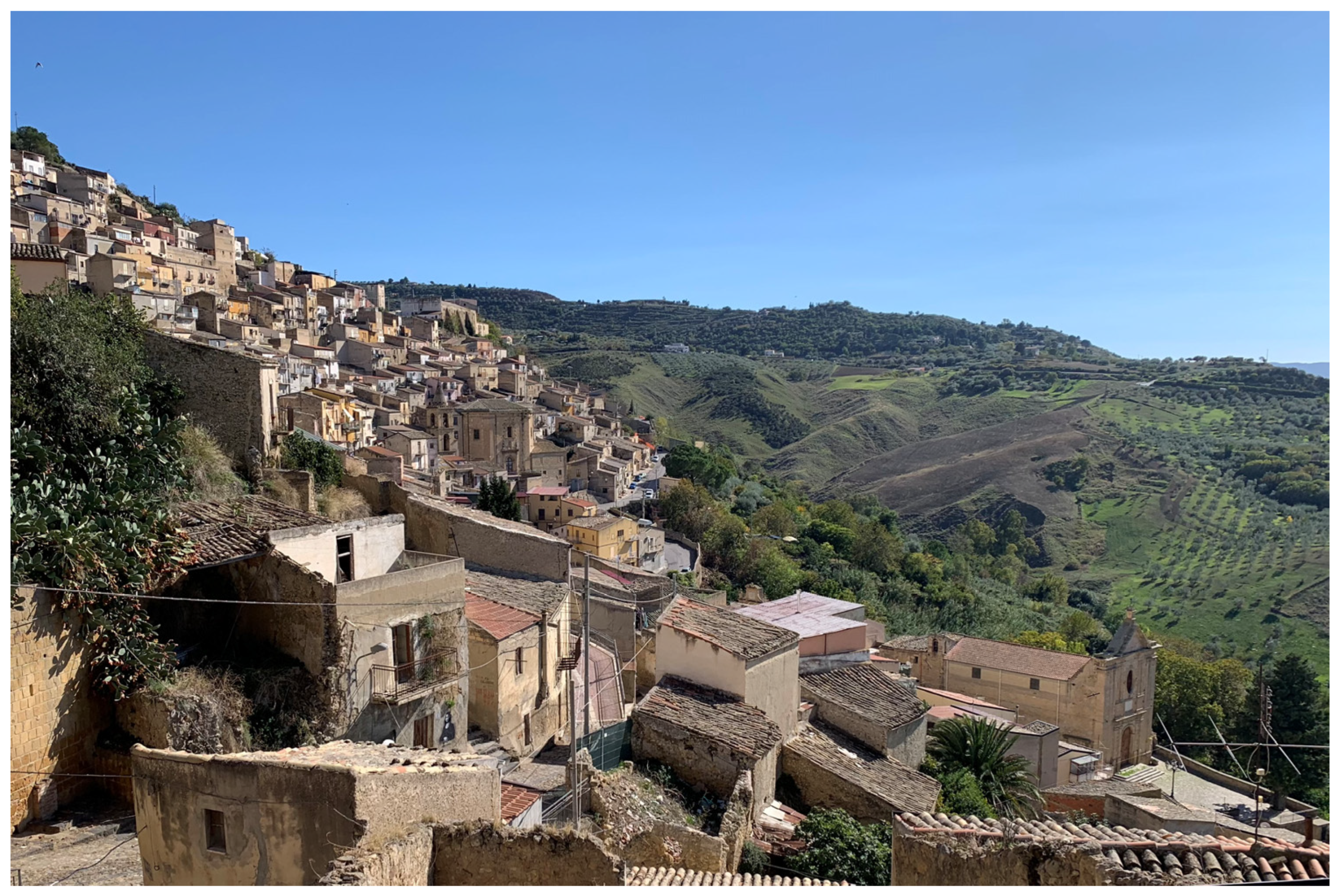
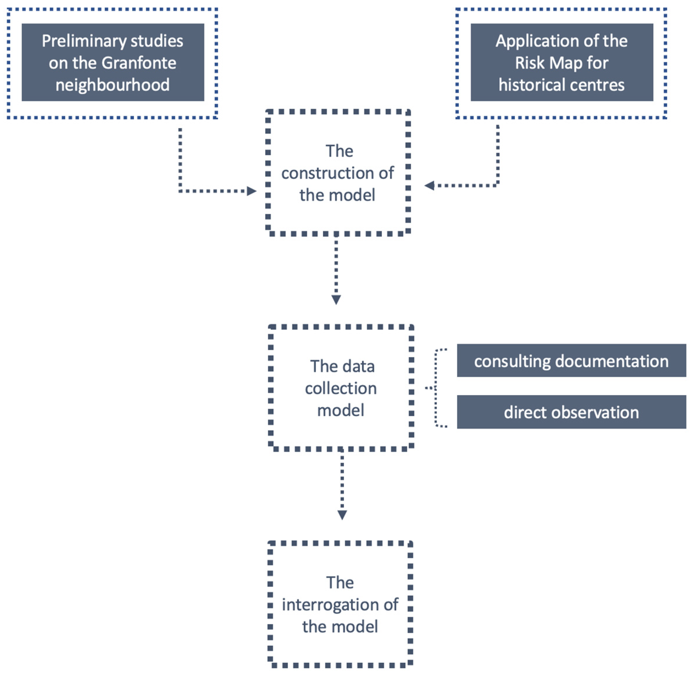
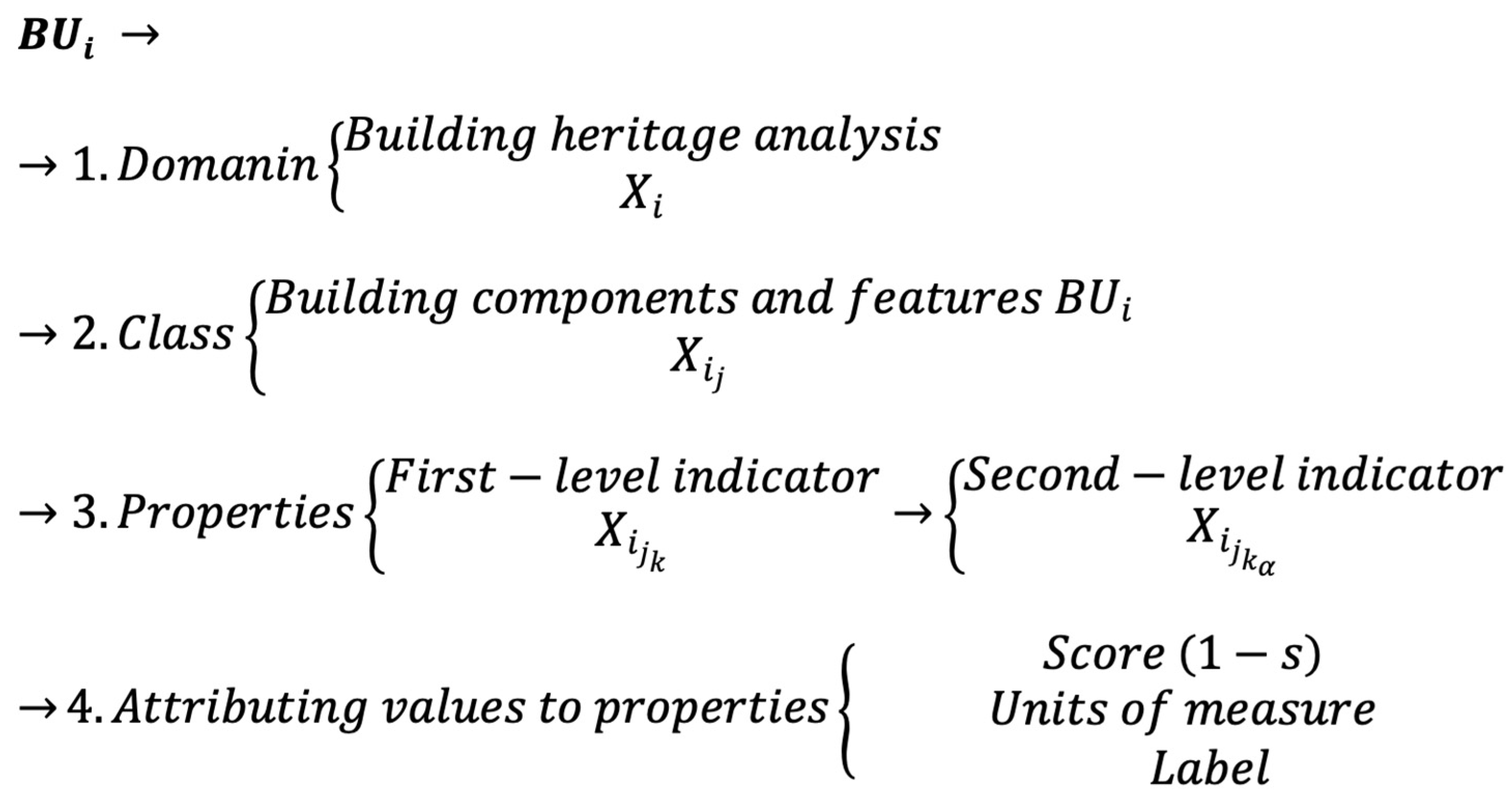
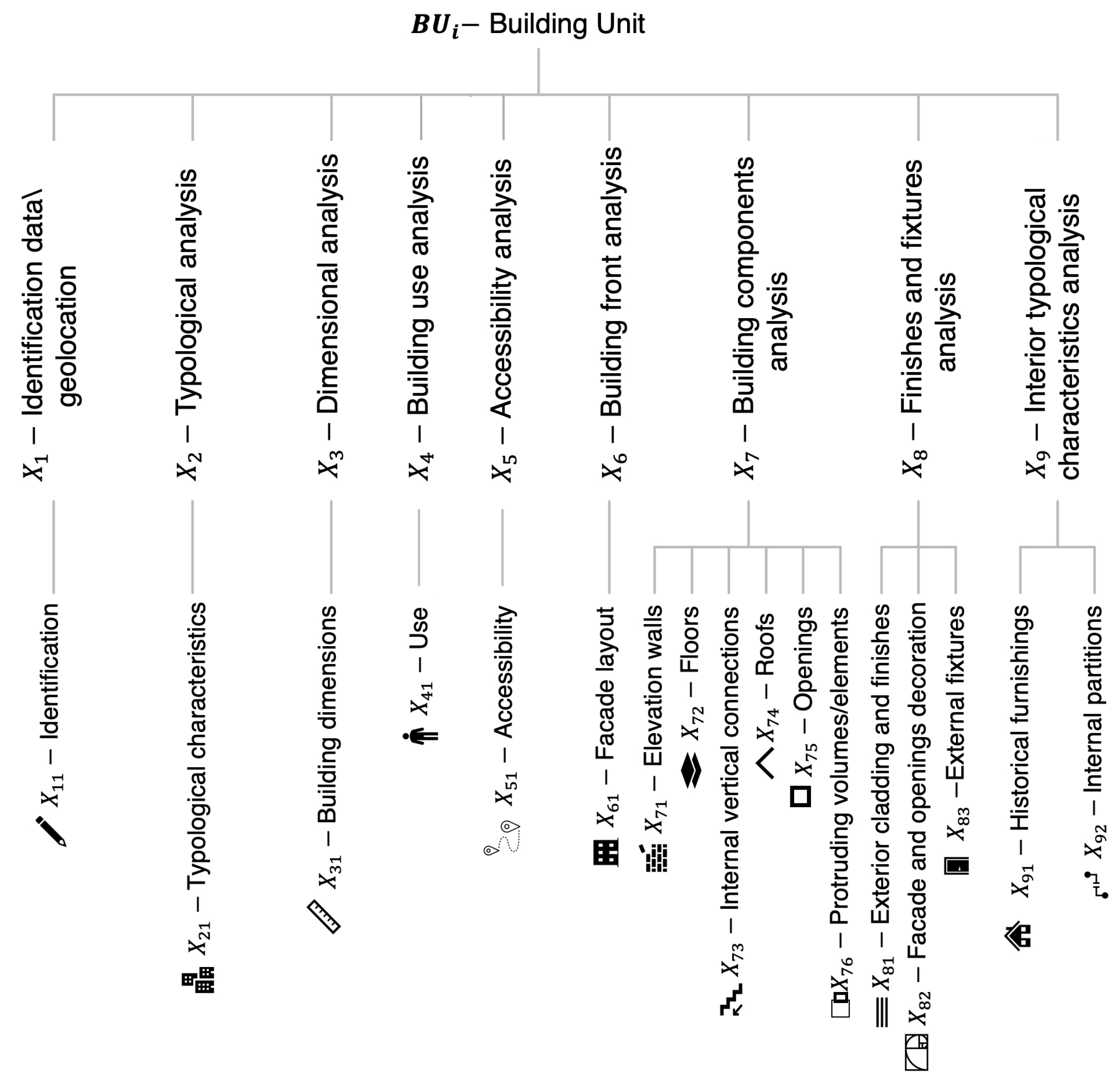
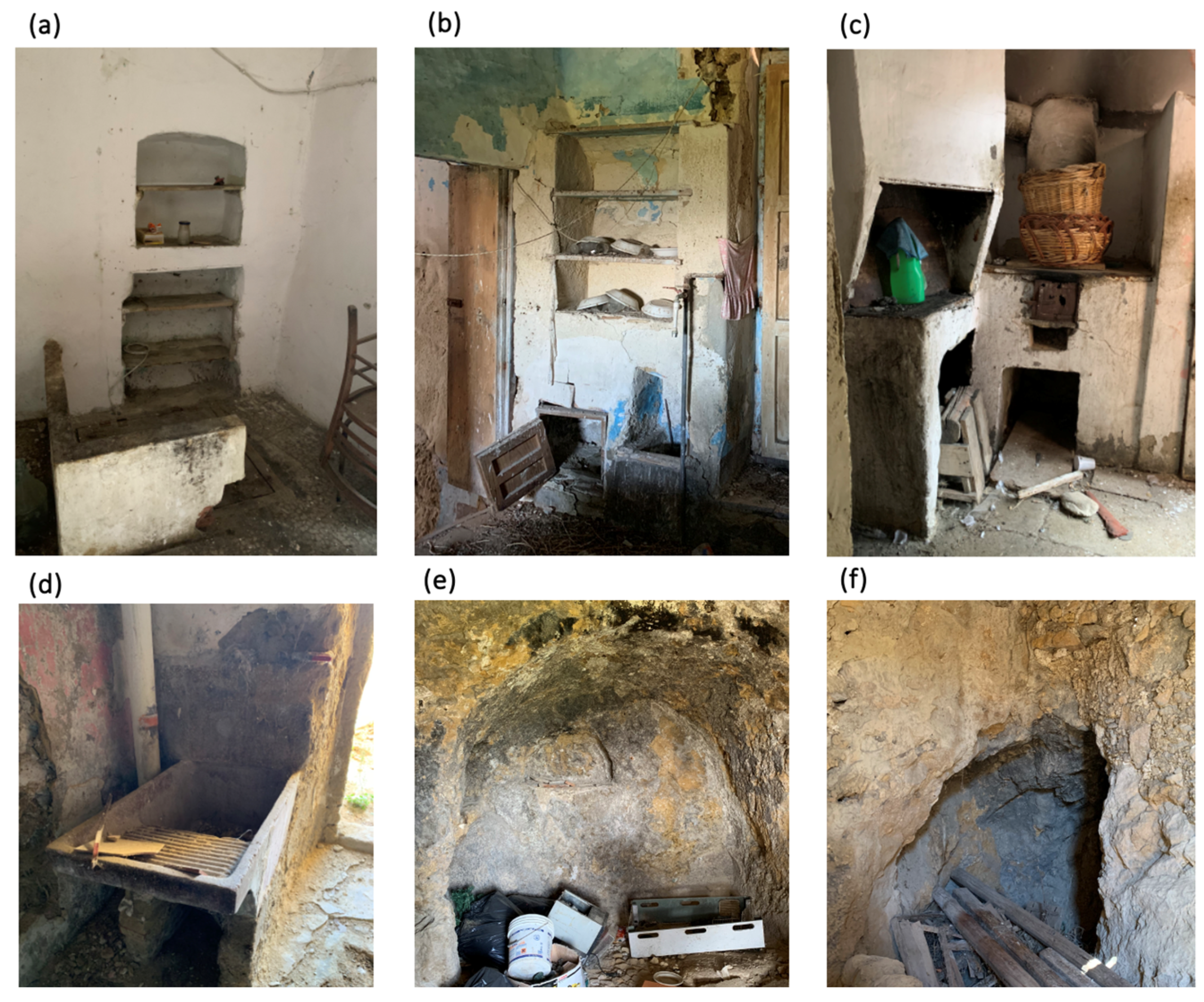
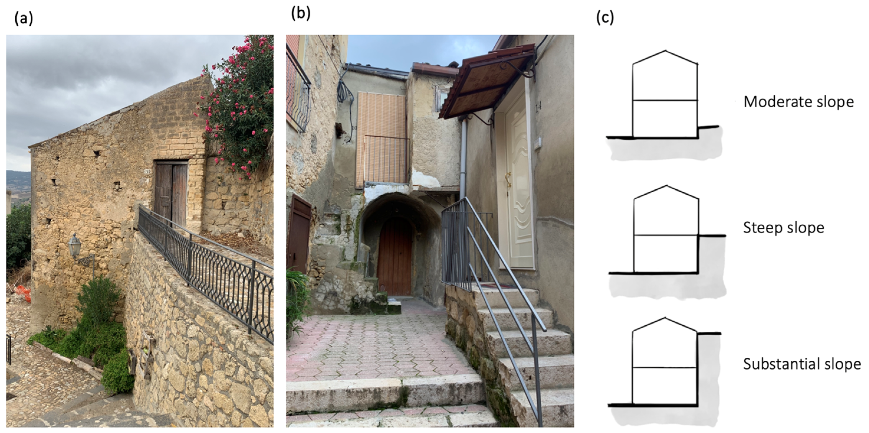
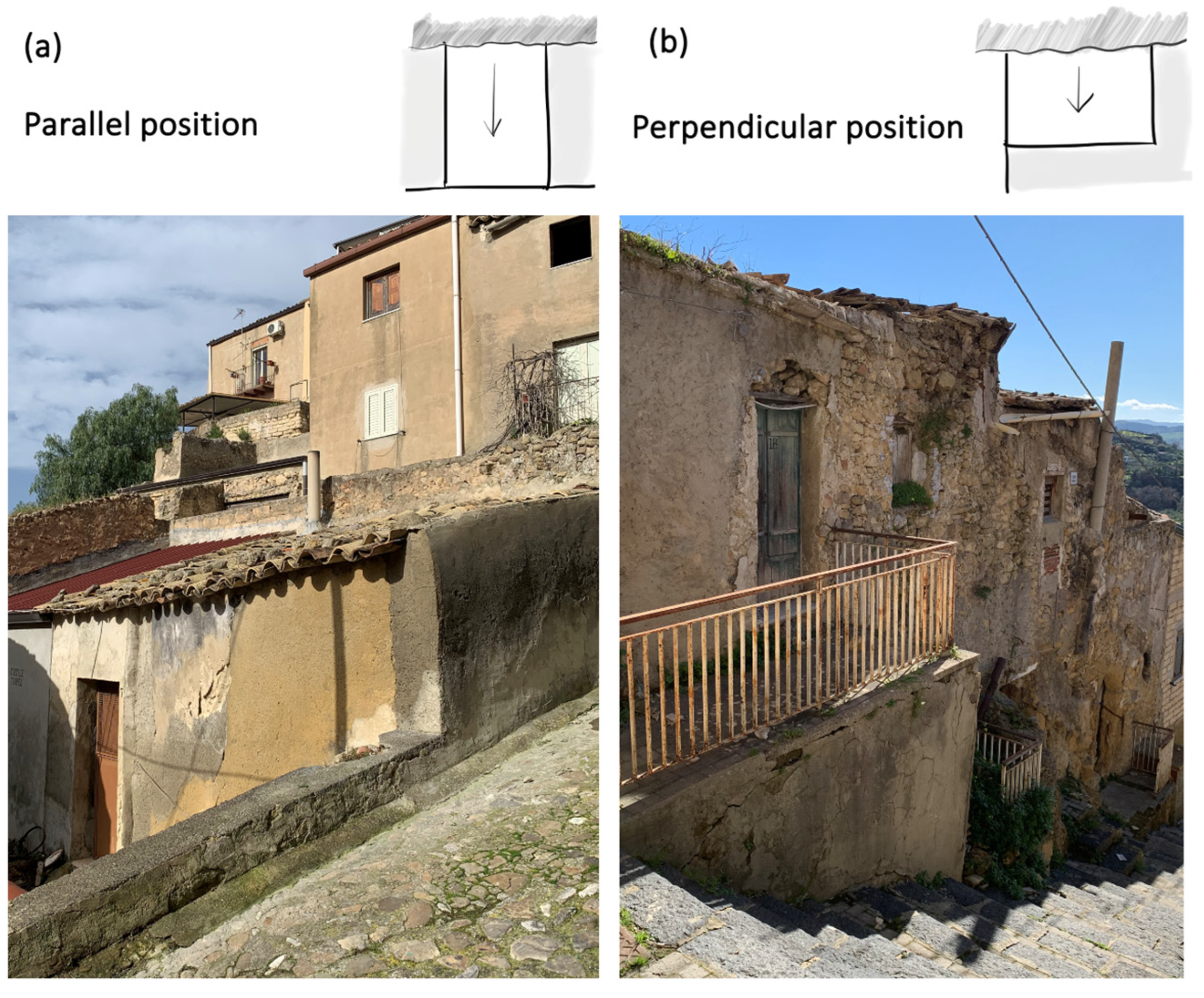
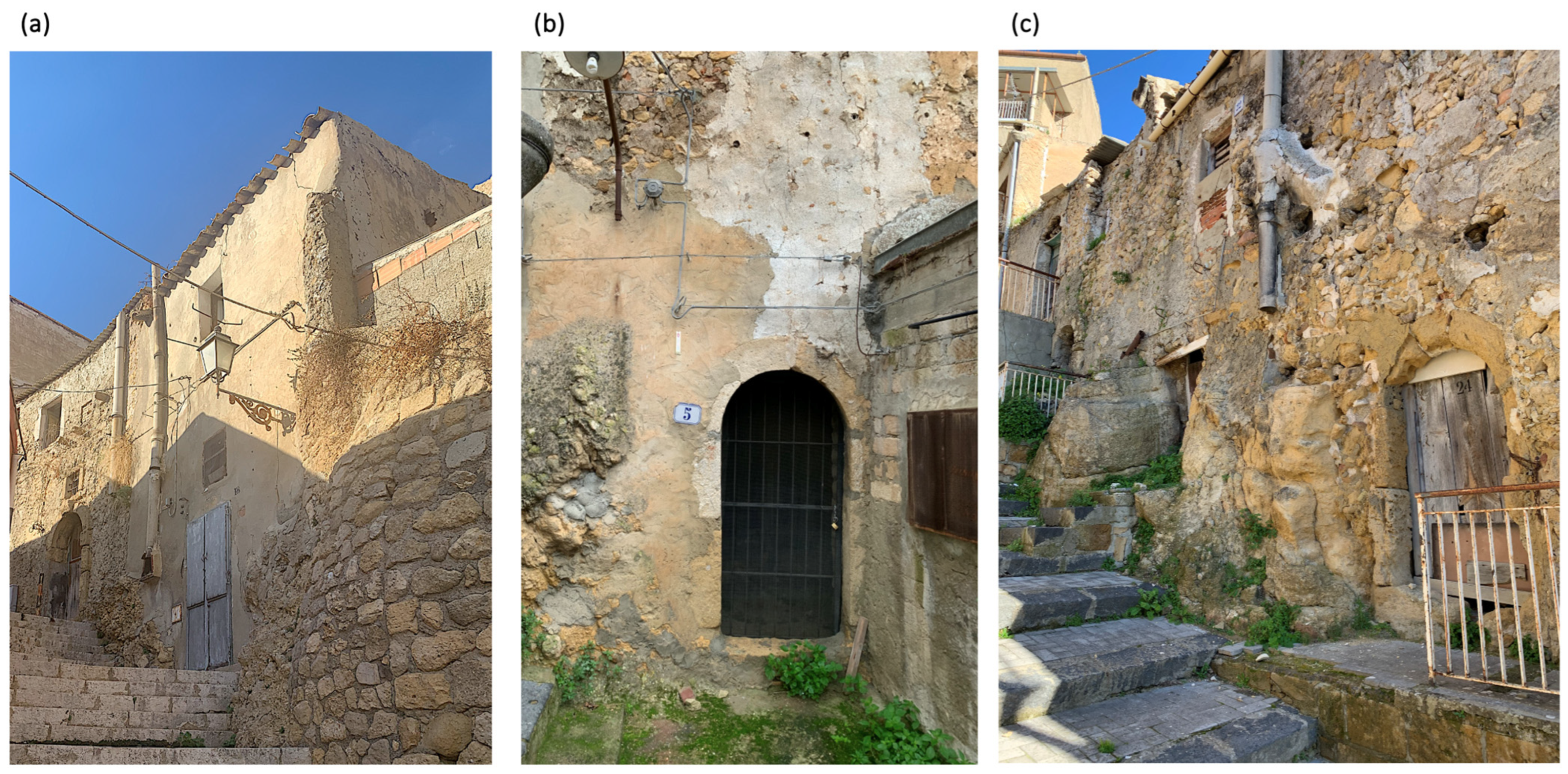
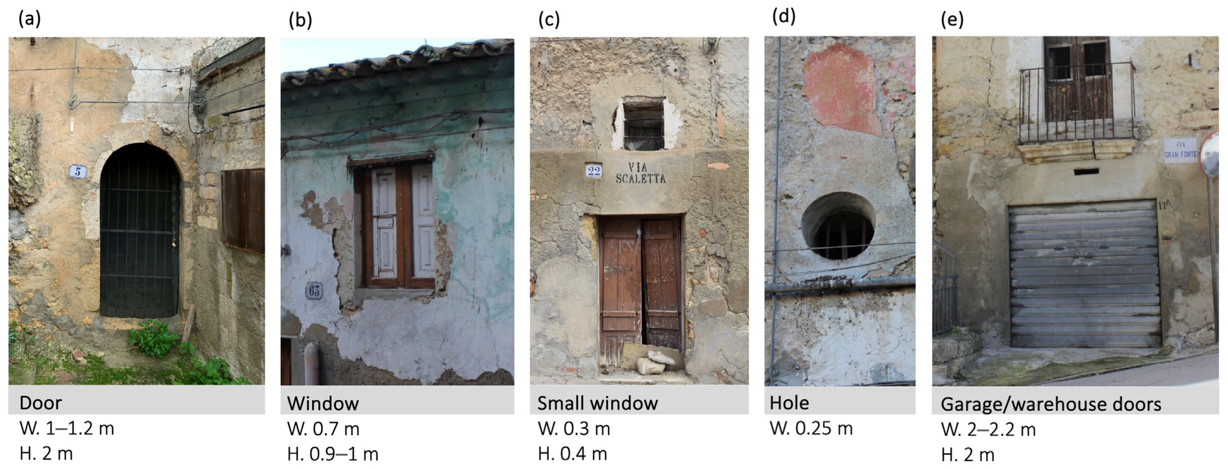
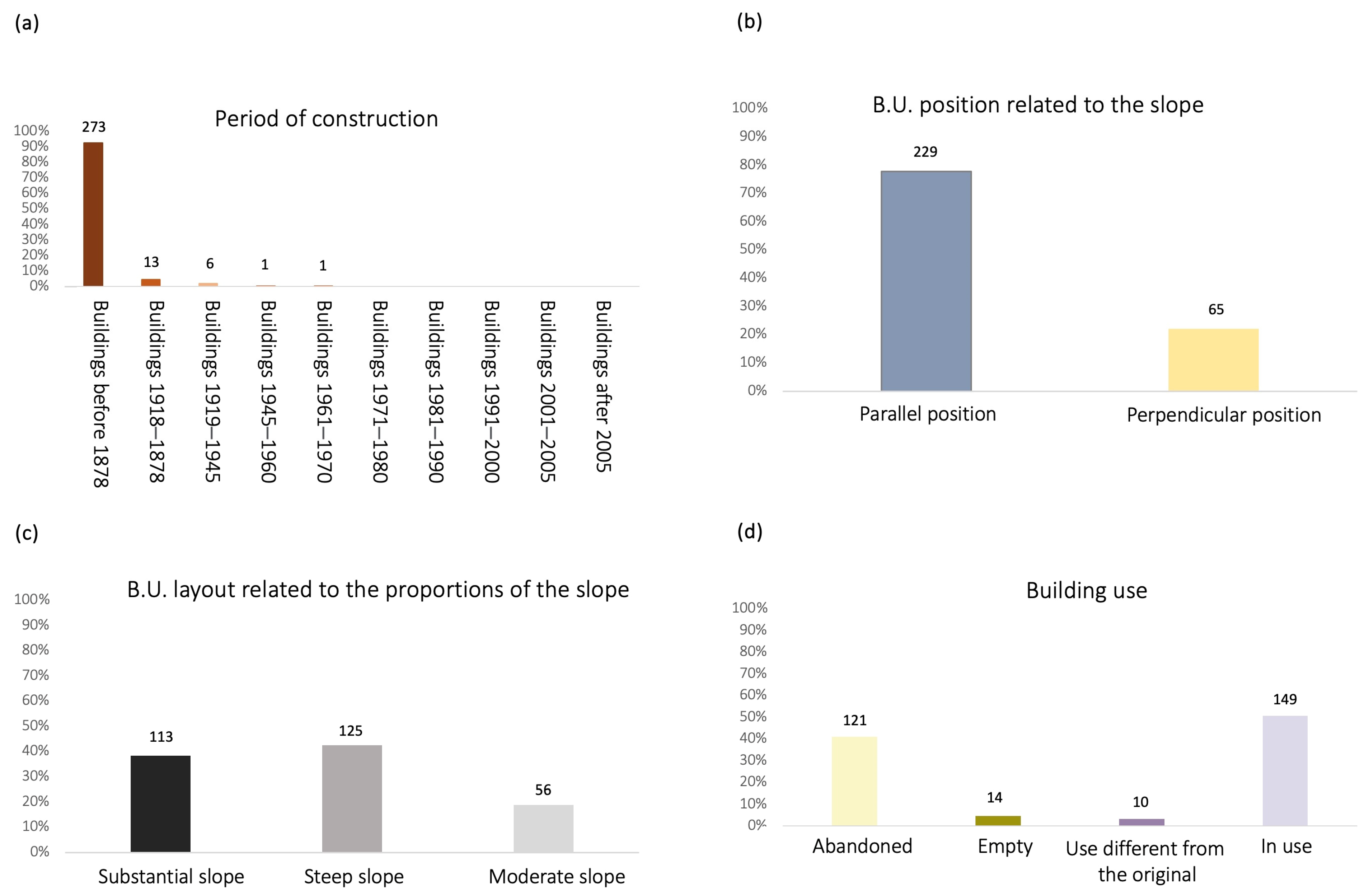
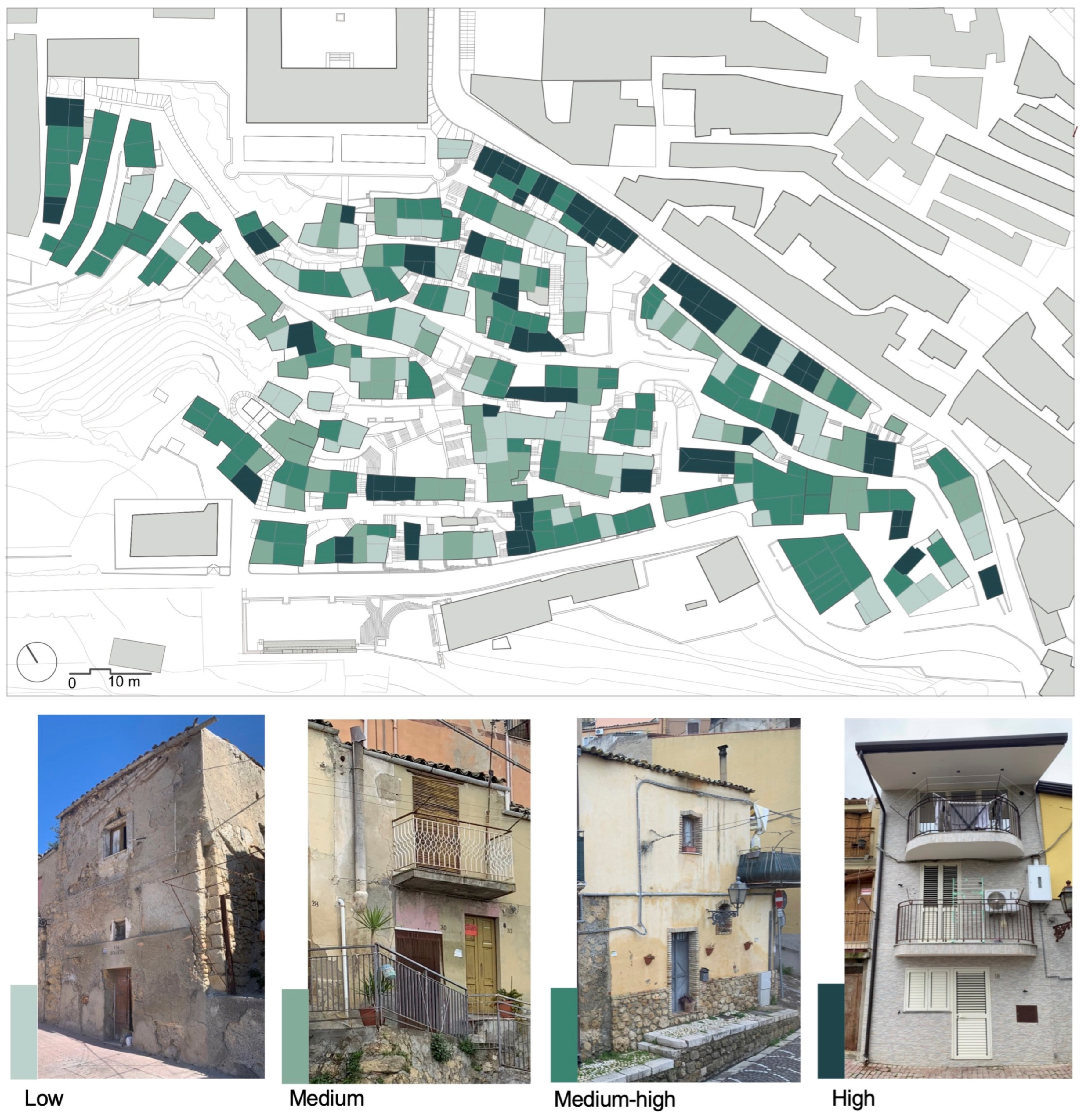
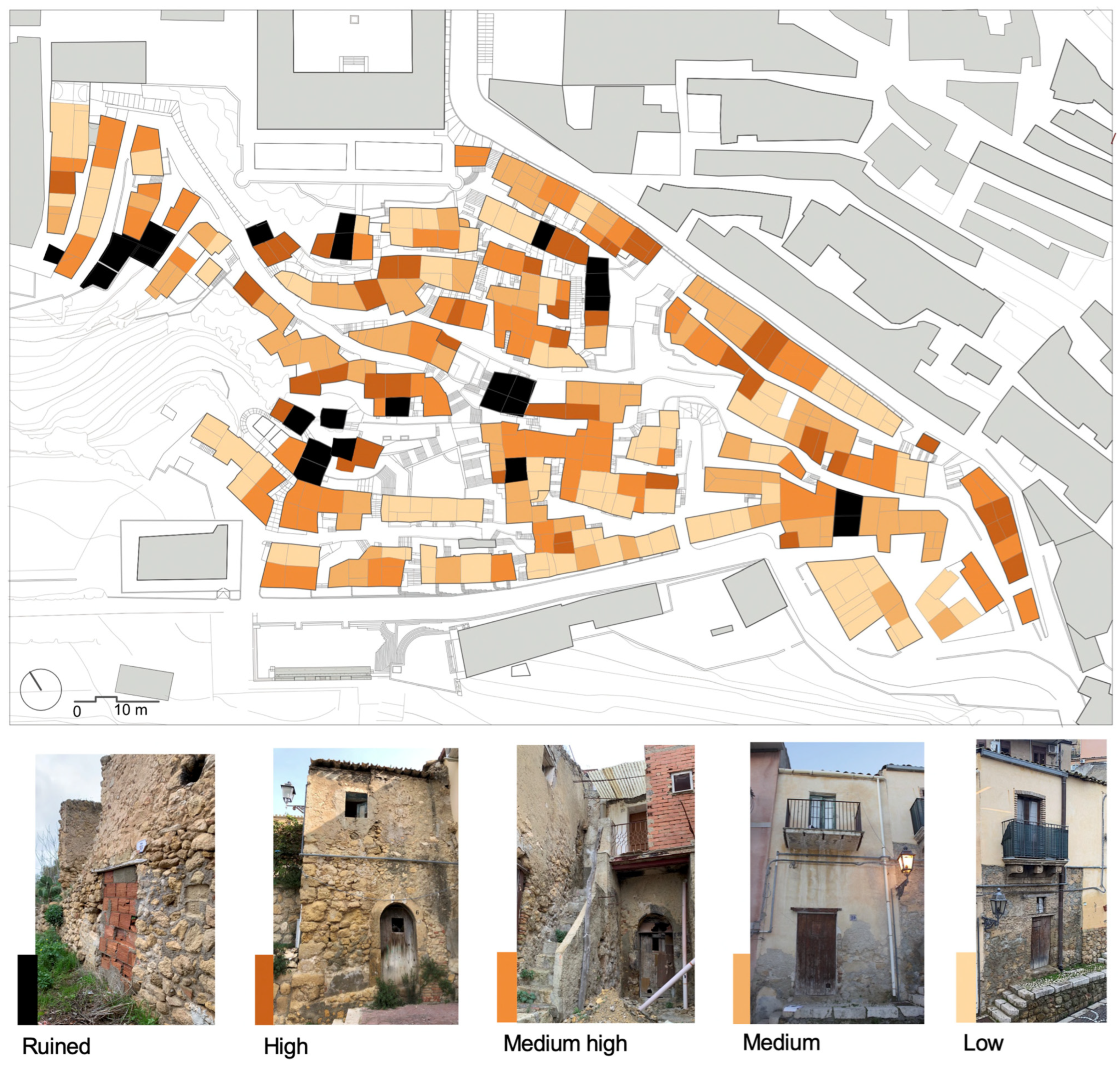
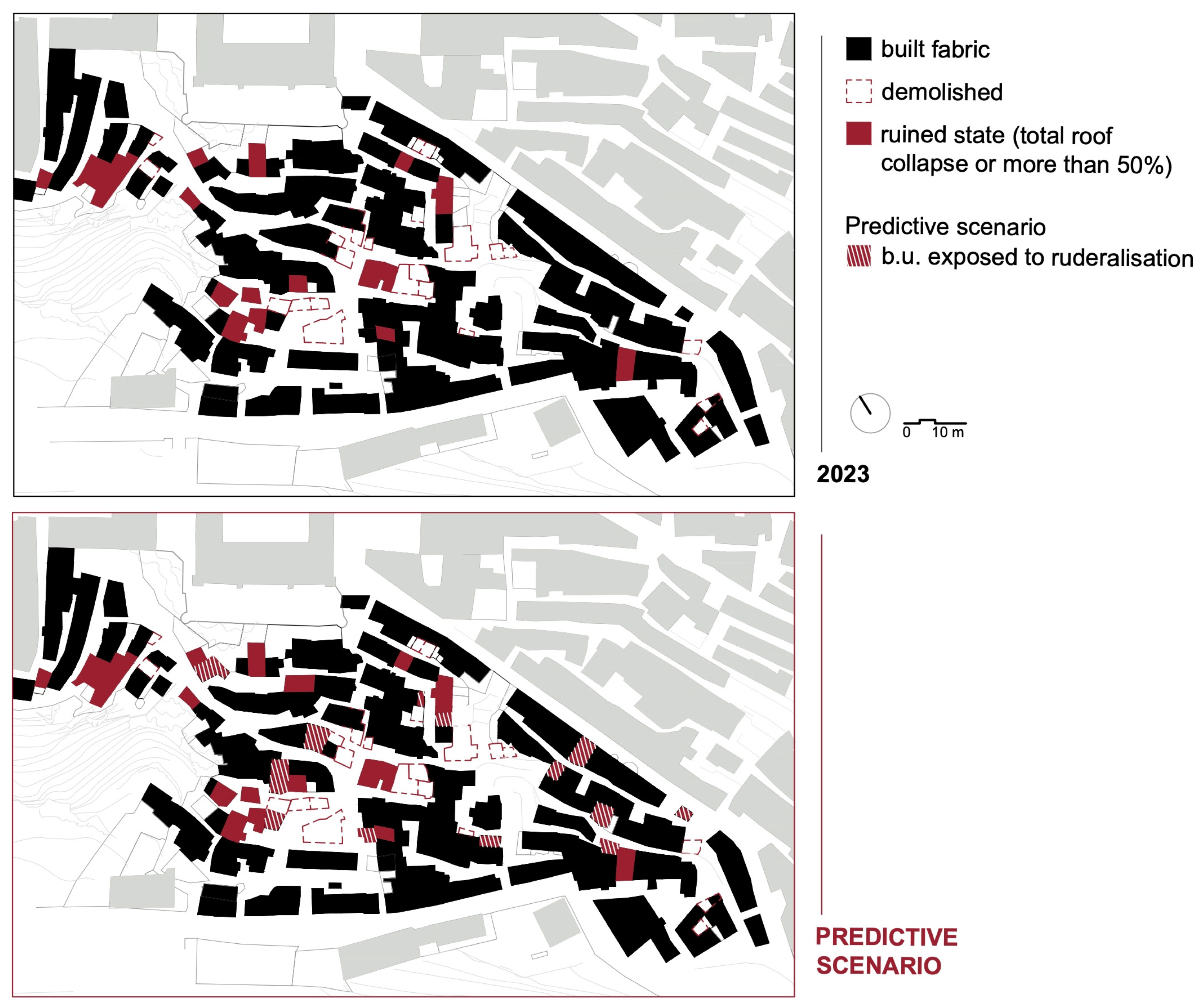
Table 1.
The properties selected to define the index.
| Class | First Level Properties | Second Level Properties |
|---|---|---|
| —Typological characteristics | —Plan changes | —Contemporary Unification |
| —Partition | ||
| —Plan changes | ||
| —Degree of densification | ||
| —Elevation changes | ||
| — uilding replacement | ||
| —Facade layout | —Opening arrangement front 1 | |
| —Opening arrangement front 2 | ||
| —Opening arrangement front 3 | ||
| —Opening arrangement front 4 | ||
| —Floors | —Wooden floor | |
| — etal floor | ||
| —Wooden loft | ||
| —Wooden mezzanine | ||
| —Metal mezzanine | ||
| —Vault | ||
| —Internal vertical connections | —Staircase in the barrel vault | |
| —Wooden staircase with rungs | ||
| —Steps carved into the rock | ||
| —Metal staircase | ||
| —Roofs | —Wooden roof | |
| —Openings | —Stone round arched portal–state | |
| —Stone round arched portal with fanlight–state | ||
| —Door with a wooden lintel and stone jambs–state | ||
| —Door with a wooden lintel and brick jambs–state | ||
| —Door with a wooden lintel and ashlar stone jambs–state | ||
| —Window with a wooden lintel and stone jambs–state | ||
| —Window with a wooden lintel and brick jambs–state | ||
| —Window with a wooden lintel and ashlar stone jambs–state | ||
| —Protruding volumes/elements | —Stone balcony–state | |
| —Metal balcony–state | ||
| —Chimney–state | ||
| —Chimney collapse | ||
| —Gutter -state | ||
| —Facade and openings decoration | —Stone architraves–state | |
| —Plaster architraves–state | ||
| —Moulded Stone architraves–state | ||
| —Cement architraves–state | ||
| —Stone quoins–state | ||
| —Stone corbels– state | ||
| —Cornice moulding–state | ||
| —External fixtures | —Doors–wooden fixtures–state | |
| —Doors–wooden fixtures–state | ||
| —Historical furnishings | —Oven/brazier–state | |
| —Washstand–state | ||
| —Wall niche with shelves–state | ||
| —Internal partitions | —Reed and plaster partitions– state |
Table 2.
The properties selected to define the index.
| Class | First Level Properties |
|---|---|
| —Elevation walls | —Level of contiguity to ruins |
| —Surface degradation | |
| —Masonry slackening | |
| —Non-structural cracks | |
| —Through-wall crack | |
| —Out of plumb | |
| —Expelled wall surface (cornerstones, wall covers) | |
| —Material disintegration | |
| —Walls collapse | |
| —Floors | —Connection to load-bearing walls |
| —Floor deformations | |
| —Breaking of parts | |
| —Floor collapse | |
| —Internal vertical connections | —Staircase collapse |
| —Roofs | —Ineffective connection to load-bearing walls |
| —Roof deformations | |
| —Breaking of parts/water infiltrations | |
| and —Roof collapse | |
| —Openings | —Reduced lintel |
| —Wooden lintel efficacy | |
| —Protruding volumes/elements | —Balcony collapse |
| —Chimney collapse | |
| —Gutter collapse | |
| —Exterior cladding and finishes | —Surface degradation |
| —Facade and openings decoration | —Surface degradation of the decoration |
| —External fixtures | —Superficial degradation of exterior fixtures. |
Disclaimer/Publisher’s Note: The statements, opinions and data contained in all publications are solely those of the individual author(s) and contributor(s) and not of MDPI and/or the editor(s). MDPI and/or the editor(s) disclaim responsibility for any injury to people or property resulting from any ideas, methods, instructions or products referred to in the content. |
© 2024 by the authors. Licensee MDPI, Basel, Switzerland. This article is an open access article distributed under the terms and conditions of the Creative Commons Attribution (CC BY) license (https://creativecommons.org/licenses/by/4.0/).
Share and Cite
MDPI and ACS Style
Trovato, M.R.; Sanzaro, D. A Knowledge and Evaluation Model to Support the Conservation of Abandoned Historical Centres in Inner Areas. Heritage 2024, 7, 1618-1664. https://doi.org/10.3390/heritage7030077
AMA Style
Trovato MR, Sanzaro D. A Knowledge and Evaluation Model to Support the Conservation of Abandoned Historical Centres in Inner Areas. Heritage. 2024; 7(3):1618-1664. https://doi.org/10.3390/heritage7030077
Chicago/Turabian StyleTrovato, Maria Rosa, and Deborah Sanzaro. 2024. "A Knowledge and Evaluation Model to Support the Conservation of Abandoned Historical Centres in Inner Areas" Heritage 7, no. 3: 1618-1664. https://doi.org/10.3390/heritage7030077