
Unveiling the Hidden Secrets of Bomarzo Cathedral: New Evidence from Last Ground-Penetrating Radar Survey


1
Archaeology and Classics Program, American University of Rome, Via Pietro Roselli 4, 00153 Rome, Italy
2
Associazione Giovanile I Mostri Bomarzo ETS, Corso Meonia 7, 01020 Viterbo, Italy
*
Author to whom correspondence should be addressed.
Heritage 2023, 6(12), 7578-7588; https://doi.org/10.3390/heritage6120398
Submission received: 29 August 2023
/
Revised: 15 September 2023
/
Accepted: 29 November 2023
/
Published: 4 December 2023
(This article belongs to the Topic Ground Penetrating Radar (GPR) Techniques and Applications)
Abstract
:The Bomarzo Cathedral, also known as the Duomo di Bomarzo, is a remarkable historical and architectural masterpiece situated in Bomarzo (VT), Italy. Constructed in the 16th century under the sponsorship of the Orsini family, the cathedral’s design is a harmonious blend of Renaissance and Baroque styles. Despite enduring numerous challenges, including damage from the Italian Wars, extensive restoration efforts were undertaken to preserve its cultural legacy. Driven by a deep appreciation of the cathedral’s historical context, a ground-penetrating radar (GPR) investigation was deployed to gain insights into its foundations and potentially uncover buried remains beneath the floor and altar. The GPR investigation focused on the cathedral’s interior, specifically the central and left naves, altar, and oratory. This revealed the presence of disclosed rectangular chambers beneath the floor and altar, along with unique foundation structures. These findings, coupled with historical insights and architectural understanding, emphasize the cathedral’s cultural importance.
1. Introduction
Bomarzo Cathedral, also known as the Duomo di Bomarzo, is an architectural marvel steeped in history and located in the charming town of Bomarzo (VT), Italy (Figure 1). Its story can be traced back to the 16th century when construction began under the patronage of the powerful Orsini family [1,2,3,4,5].
The medieval church, mentioned in some documents from the second half of the 13th century (Ecclesia Sancte Marie), had the same orientation as the current building, with the facade facing northeast onto the main square of the settlement [2].
In 1502, Giovanni Corrado Orsini inherited the fiefdom of Bomarzo, along with that of Chia, the territory of Colle Casale, and the estate of Monte Casoli. He initiated a series of works which, after his death, were continued by his son, Pier Francesco, better known by the nickname Vicino. Firstly, between 1509 and 1511, the Church of S. Maria Assunta was demolished and reconstructed, and the square in front of it was redefined by eliminating the moat that separated the village from the castle and demolishing some medieval houses. The works in the place of worship continued in 1531 when the interior flooring was completed, and in 1836, when the external staircase was built. They were finalized by Giulia Farnese in 1546 [3,6]. The new cathedral’s foundation was laid in 1557, with the esteemed architect Antonio da Sangallo the Younger leading the initial design. However, following his untimely demise, the project was entrusted to the skilled hands of the talented architect Pirro Ligorio, renowned for his expertise in Renaissance architecture [2,7].
During the course of its construction, the cathedral underwent several modifications and renovations, each contributing to its distinctive character. The façade, a captivating fusion of Renaissance and Baroque styles, proudly exhibits intricate carvings and ornate details. The imposing bell tower stands tall, serving as a symbol of spiritual and communal significance for the people of Bomarzo [1,8,9,10].
The cathedral is home to a treasure trove of artistic masterpieces. The awe-inspiring altarpiece, painted by the renowned Mannerist artist Girolamo Siciolante da Sermoneta, mesmerizes visitors with its exquisite beauty. The delicate frescoes adorning the ceiling narrate biblical stories and other sacred motifs, crafted by the skilled hands of local and renowned artists of that era [1,2]. Therefore, an inscription commemorates the translation of the body of Saint Anselm, which took place in 1647 at the behest of Ippolito Lante della Rovere, Duke of Bomarzo, during a more extensive renovation of the church. On that occasion, the marble case containing the Saint’s remains, previously bricked into the church floor in front of the altar of Saint Sebastian (at the end of the right nave), was removed and placed in the main altar; subsequently, in 1860, the relics were placed in another urn, but the precise location remains uncertain [1,3,4].
However, the history of Bomarzo Cathedral is not without its challenges. During the tumultuous times of the Italian Wars, it suffered significant damage and neglect. Diligent restoration efforts were undertaken in the subsequent centuries to preserve its cultural heritage and restore its architectural grandeur [2,4].
Over the years, Bomarzo Cathedral has served as an enduring symbol of hope, faith, and community. Its grandeur has borne witness to countless weddings, funerals, and various religious ceremonies, commemorating significant moments in the lives of the townspeople. Additionally, within the church premises, a remarkable sight greeted visitors until the 1970s, i.e., seven burial wells, which were solemn reminders of the passage of time. Regrettably, only one of these wells remains visible today [1,4,10].
In the 1970s, under the supervision of Father Sergio, it was determined that the stone flooring of the church needed to be replaced with a superior product, specifically Tuscan terracotta. During the demolition of the old flooring, no significant traces of burials were discovered, except for one of a woman found at the base of a pillar in the left lateral nave. A local historian present during the renovations claims to have inspected the burial wells on this occasion and noted the presence of certain objects of interest, including wooden coffins and a sword [4,6]. Subsequently, in the 1990s, the flooring underwent further replacement, ensuring that the materials used remained in harmony with the church’s architectural style [1,4,6].
Today, the Duomo di Bomarzo continues to captivate visitors from around the world, inviting them to step into its rich history, marvel at its splendid architecture, and immerse themselves in the spiritual ambiance that has endured for centuries.
In light of these historical events and the specific capabilities of instruments [11,12,13], the acquisition of ground-penetrating radar (GPR) data was crucial. The initial hypothesis aimed to unravel the intricate formation and structure of the church’s foundations, while also uncovering any potential burials beneath its floor, including beneath the altar. The results will be useful for future planned restorations.
2. Materials and Methods
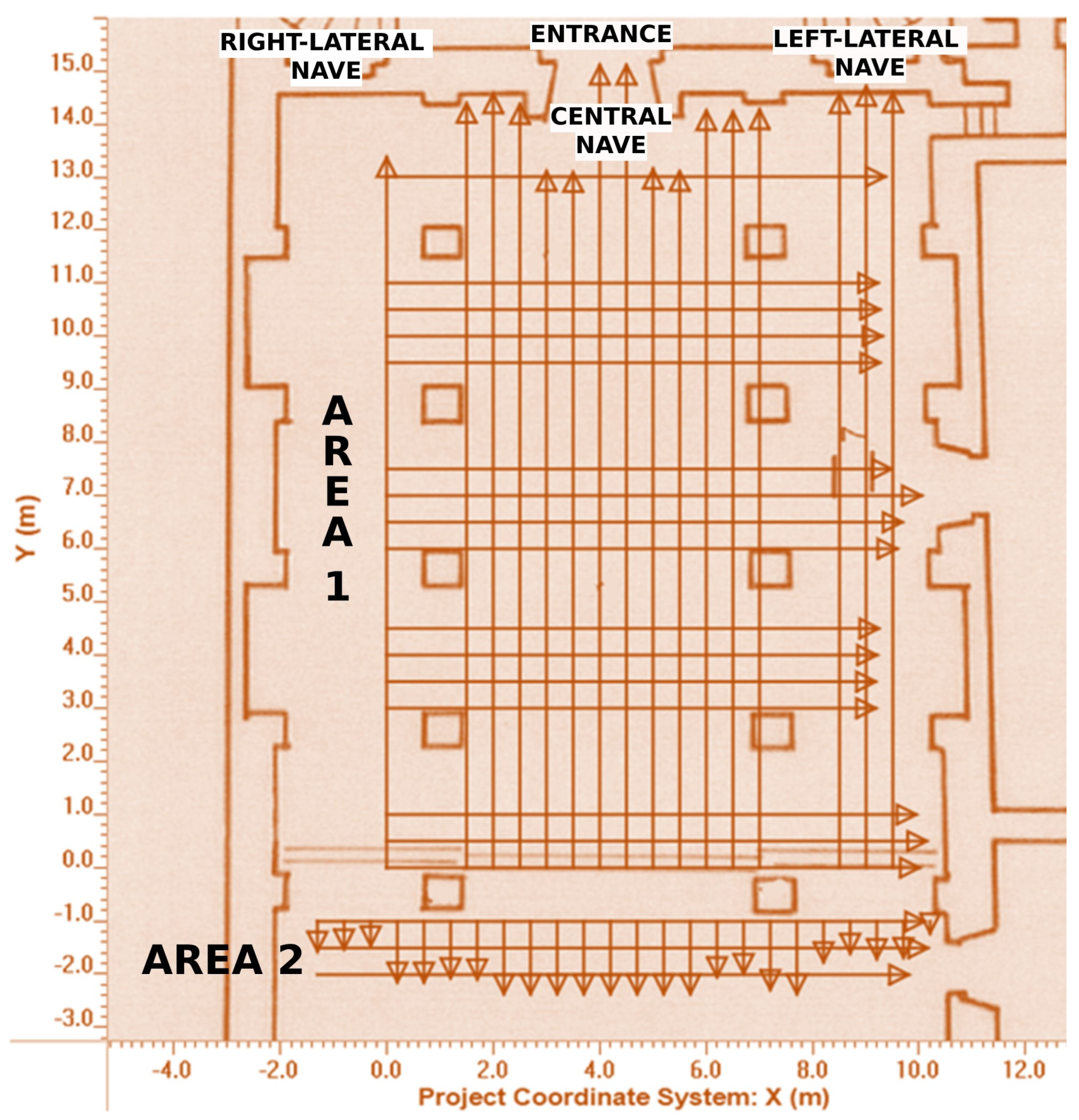
The area under investigation with the GPR is the interior of the Bomarzo Cathedral, specifically the central and left naves, altar, and oratory. This church comprises three naves and three altars, with one main and two minor altars. Additionally, there are smaller altars positioned along the lateral naves, accompanied by a series of benches that have been removed to facilitate the movement of the instrumentation without any hindrance.
The GPR equipment employed for this study was the Noggin® SmartCart® (Sensors & Software, Inc., Mississauga, ON, Canada) with 500 MHz antennas. The areas of particular interest were found to be around the columns of the naves and beneath the altar. To thoroughly investigate the majority of these areas, two main GPR grids were created, aligned along the X and Y axes, covering a total of 500 linear meters (Figure 2). In particular, the acquisition was carried out by conducting a series of equidistant parallel profiles spaced at 0.5 m, creating two bidirectional grids (along the X and Y directions) of different sizes (10 × 15 m and 12 × 1 m).
The purpose of this study was to comprehensively survey the entire area of interest, with the exception of a portion of the right lateral nave for which the stratigraphy is already known. To ensure consistency in data collection, the grids in both areas were designed with similar parameters, taking into account the similarities in the soil composition and dielectric constant conditions (0.5 m interline; 2.5 cm step-size; stacking 4; v = 0.85 m/ns, using the hyperbola calibration; setting of the zero-time position relative to the ground surface). The gathered data exhibited high quality, and images were further set to “amplify” the strength of the GPR data signals in both the GPR lines and depth slices. The processing for both areas used a combination of dewow, migration, envelope (DME), background subtraction, and SEC2 gain (start gain 7.5, attenuation 5, and maximum 2000) [11,14,15,16].
3. Results
Initially, a subsurface scan of the area under investigation is conducted by collecting a series of parallel GPR profiles or radargrams. These two-dimensional stratigraphies aim at obtaining slices or maps at various depths. This scanning is performed over the main flooring of the church and its altar. GPR serves as an effective quality assurance (QA) and quality control (QC) tool for examining complex stratigraphies within cultural heritage buildings like this church. Its non-invasive nature preserves historical structures, while its high-resolution imaging capabilities help detect hidden features, structural anomalies, and several crucial pieces of information relevant to the geophysical investigation. Moreover, GPR’s depth profiling, real-time data collection, and data integration with archaeological and historical records enhance the QA/QC process [17,18,19,20,21].
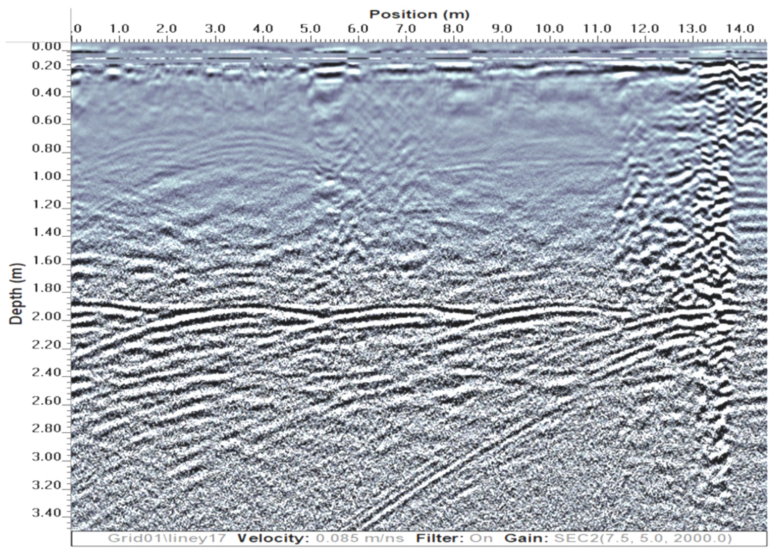
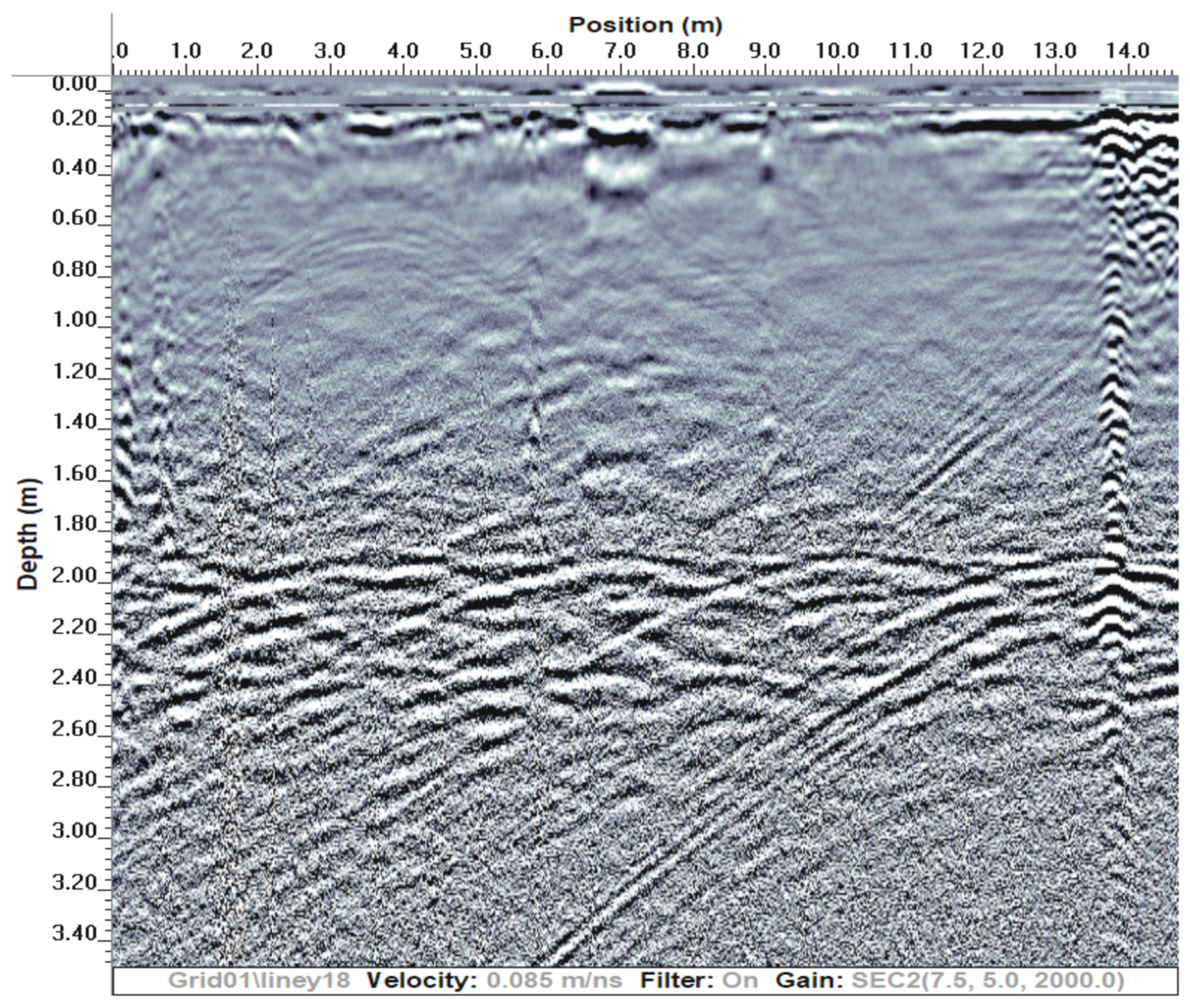
Based on the above-mentioned radargrams, the stratigraphy beneath the central nave appears to be mostly uniform. It comprises a consistent and conductive material that resembles the presence of a natural tuff rock substrate (Figure 3). However, the stratigraphy beneath the lateral naves, particularly the left one, exhibits well-defined structural elements, which indicate the presence of anthropic substructures at a depth of approximately 2 m. Moreover, above this presumably anthropogenic structure, there is a layer of soil upon which the church floor rests, which clearly attenuates the electromagnetic signal (Figure 4).
When the depth slices were generated, they allowed for the planimetric definition of not only the dimensions but also of the depth and geometry of the buried anomalies detected using the GPR. This highlights two fundamental manmade features: the potential presence of rectangular voids beneath the floor (at a depth of 0.5 m) and the existence of artificial foundation structures supporting the church itself (at a depth of 2 m) (Figure 5 and Figure 6). In the range between these two measurements, there appears to be a soil fill that significantly attenuates the electromagnetic signal, but no clear anomalies are present.
4. Discussion
As often happens when using GPR to investigate historical buildings [22,23,24,25,26,27,28,29], the results obtained from this study reveal the presence of an intriguing stratigraphy that holds both historical–cultural and structural significance. Through a careful analysis of the processed data, it is possible to confidently confirm the existence of at least four rectangular chambers beneath the flooring and altar, situated at a depth of approximately 0.5 m from the ground level (Figure 5). Notably, while one of these chambers is visible on the surface and it was partially investigated, the remaining three under the pavement have been newly discovered, demanding further investigations as potential burial sites due to their dimensions and depth as normally happened in the past. These discoveries warrant careful attention for potential future invasive studies.
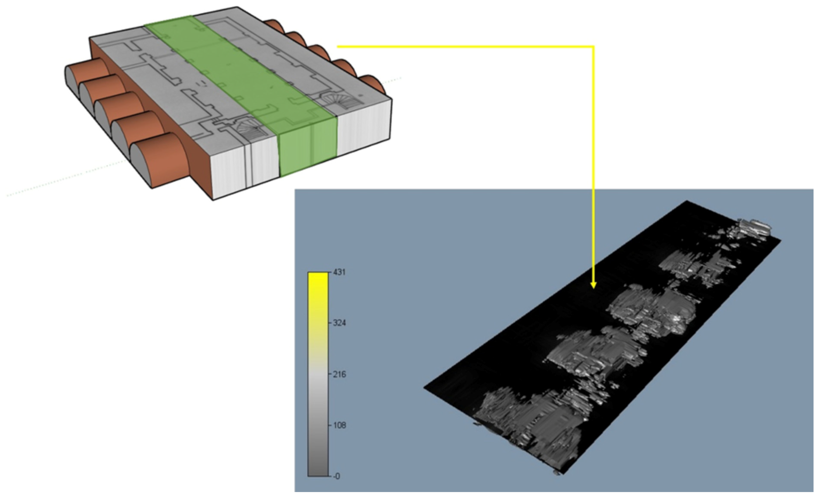
Furthermore, the ground-penetrating radar survey has imparted valuable insights into the foundations of the church. It has revealed a typical structure with a central core located beneath the central nave, which is supported by a natural rock block, likely to be composed of tuff. Additionally, there is a hidden manmade left lateral structure that mirrors the barrel-vaulted one, serving to support the right lateral naves. This particular structure is the only one visible from outside on the right side of the church (Figure 7) and can also be partially observed in the GPR data presented in Figure 6. Its purpose was to increase the supporting subsurface area of the church. Figure 8 illustrates a pseudo-3D reconstruction of the anomaly using the isosurface created with the average envelope amplitude (AEA) values thanks to the Voxler® 4 software [30].
If this particular foundation configuration is quite unique among coeval and neighboring churches, it is not uncommon in earlier periods. In fact, it has been utilized since ancient times in various Italian and foreign locations, whenever circumstances demanded the expansion of the foundation plane by integrating the natural substrate with a newly created anthropic element [31].
The significance of these findings and the discoveries made hold the potential for profound implications, offering substantial benefits that extend beyond the immediate scope of future restoration and conservation efforts. They have the power to enrich the cultural heritage of the Bomarzo region through the acquisition of fresh insights into its historical and archaeological past.
First and foremost, the insights derived from this research can be instrumental in guiding and shaping future endeavors related to the restoration and conservation of heritage sites in the Bomarzo territory. By providing a deeper understanding of the underlying structures and historical context, these findings can inform preservation strategies, ensuring that any restoration work is carried out with the utmost accuracy and respect for the site’s historical integrity. This, in turn, enhances the prospects of preserving these invaluable cultural assets for generations to come.
Beyond the realm of conservation, the newfound knowledge contributes significantly to the enrichment of the cultural heritage of Bomarzo. It serves as a window into the past, unraveling previously unknown aspects of the region’s history and archaeology. Such discoveries not only deepen our appreciation of the past but also shed light on the social, economic, and cultural dynamics that once shaped Bomarzo. This, in essence, transforms the region into a living archive of historical and archaeological treasures.
Moreover, these revelations offer opportunities for further research and exploration. Scholars and historians can delve deeper into the historical context, building upon the foundation laid by this research to uncover even more hidden stories and connections. By doing so, they contribute to the broader body of knowledge in the fields of history and archaeology, potentially leading to a reevaluation of existing historical narratives and the emergence of new perspectives.
5. Conclusions
The study of Bomarzo Cathedral, a historical and architectural gem located in Bomarzo, Italy, has yielded significant insights into its rich history and structural characteristics, thanks to new evidence obtained through a GPR survey.
The investigation focused on the cathedral’s interior, encompassing the central and left naves, as well as the altar and oratory. Particularly intriguing areas of particular were identified around the columns and beneath the altar. The results unveiled a uniform stratigraphy beneath the central nave, suggesting the presence of a natural tuff rock substrate. Conversely, the stratigraphy beneath the lateral naves displayed well-defined anthropic substructures at a depth of around 2 m. Depth slices generated from the GPR data allowed for the detailed analysis of buried anomalies, revealing rectangular voids beneath the floor and artificial foundation structures supporting the church.
By incorporating historical context, architectural expertise, and geophysical methods, this research illuminates the significance of the Bomarzo Cathedral as a cultural heritage site. The revelations of buried chambers and foundation configurations not only enhance academic understanding but also provide valuable insights for potential future investigations and restorations. This study underscores the enduring allure of Bomarzo Cathedral, inviting visitors from around the world to appreciate its historical legacy, architectural elegance, and timeless spiritual ambiance.
The value of these results and discoveries extends far beyond their immediate application in restoration and conservation efforts. They have the potential to breathe new life into the cultural heritage of Bomarzo, providing a deeper understanding of its history and archaeology while opening doors to further exploration and scholarship. As such, they represent a pivotal contribution to the preservation and enrichment of the region’s unique cultural legacy.
Author Contributions
Conceptualization, P.M.B. and G.L.; methodology, P.M.B.; software, P.M.B.; validation, P.M.B. and G.L.; formal analysis, P.M.B.; investigation, P.M.B.; resources, P.M.B. and G.L.; data curation, P.M.B. and G.L.; writing—original draft preparation, P.M.B.; writing—review and editing, P.M.B. and G.L.; visualization, P.M.B. and G.L.; supervision, P.M.B. and G.L.; project administration, P.M.B. and G.L.; funding acquisition, G.L. All authors have read and agreed to the published version of the manuscript.
Funding
This research was funded by Progetto Vicino Monster Park related to the Bando delle Idee Vitamina G2 (CUP: F34J22001110002).
Data Availability Statement
The data are available in the Italian Ministry of Culture and the Soprintendenza Archeologia, Belle Arti e Paesaggio per la provincia di Viterbo e per l’Etruria meridionale (SABAP-VT-EM) database with limited access as requested by law.
Acknowledgments
The authors have received the legal permits from the Italian Ministry of Culture and the Soprintendenza Archeologia, Belle Arti e Paesaggio per la provincia di Viterbo e per l’Etruria meridionale (SABAP-VT-EM), Concessione prot. MIC_SABAP-VT-EM_U03 26/04/2023 0006732-P, 11 May 2023 and 19 May 2023. The authors would like to acknowledge the help and support of Beatrice Casocavallo, Daniela Alessandrelli, ing. Santino Tosini, Angelo Fiaschetti, the Diocese of Viterbo, Father Cyrill, and the Associazione Giovanile I Mostri Bomarzo ETS.
Conflicts of Interest
The authors declare no conflict of interest.
References
- Arduini, M.; Dolores Leuzzi, M.; Gabriella Palmisciano, M.; di, P. Tradizioni Orali A Bomarzo; Editoriale Umbra SAS: Foligno, Italy, 1983. [Google Scholar]
- Maria Paola Baglione. Il Territorio di Bomarzo; Ricognizioni archeologiche in Etruria 2; Consiglio Nazionale delle Ricerche: Roma, Italy, 1976. [Google Scholar]
- Vittori, L. Memorie Archeologico-Storiche Sulla Città di Polimarzio Oggi Bomarzo; The British Library: London, UK, 2010. [Google Scholar]
- Associazione Giovanile I Mostri di Bomarzo. La Chiesa di Santa Maria Assunta in Cielo di Bomarzo-Notizie Storiche Dalle Origini ad Oggi; Regione Lazio: Bomarzo, Italy, 2023. [Google Scholar]
- Elisabetta, M. L’Archivio Orsini; Carte Scoperte; Viella-Archivio Capitolino: Roma, Italy, 2016; ISBN 978-88-6728-669-0. [Google Scholar]
- Archeoparco. Tributo a Vicino Orsini-Progetto Finalizzato e Destinato al Gruppo Informale Giovani I Mostri per la Partecipazione al Bando Vitamina G; Regione Lazio: Bomarzo, Italy, 2022. [Google Scholar]
- Gasperoni, T.; Scardozzi, G. Bomarzo, Mugnano, Bassano in Teverina: I.G.M. F137 I SO Attigliano, II NO Soriano nel Cimino; Università degli Studi della Tuscia: Viterbo, Italy, 2010. [Google Scholar]
- Giannini, P. Centri Etruschi e Romani Dell’etruria Meridionale; Tipolitografia Ceccarelli: Viterbo, Italy, 1900. [Google Scholar]
- Dennis, G. Cities and Cemeteries of Etruria (1848); University of Chicago: London, UK, 1848. [Google Scholar]
- Cenci, D.S. Anselmo Vescovo e Confessore, Protettore di Bomarzo: Cenni Storici Sulla Vita, sui Miracoli, Sulla Venerazione del Santo; Tipografia Unione: Viterbo, Italy, 1946. [Google Scholar]
- Barone, P.M. Understanding Buried Anomalies: A Practical Guide to GPR; LAP LAMBERT Academic Publishing: Saarland, Germany, 2016; ISBN 978-3-659-93579-4. [Google Scholar]
- Barone, P.M.; Swanger, K.J.; Stanley-Price, N.; Thursfield, A. Finding Graves in a Cemetery: Preliminary Forensic GPR Investigations in the Non-Catholic Cemetery in Rome (Italy). Measurement 2016, 80, 53–57. [Google Scholar] [CrossRef]
- Barone, P.M.; Ferrara, C. The Past beneath the Present: GPR as a Scientific Investigation for Archaeology and Cultural Heritage Preservation. Int. J. Conserv. Sci. 2017, 8, 581–588. [Google Scholar]
- Annan, A.P. Ground Penetrating Radar: Principles, Procedures & Applications; Sensors & Software Incorporated: Mississauga, ON, Canada, 2003. [Google Scholar]
- Persico, R. Introduction to Ground Penetrating Radar; IEEE Press: Piscataway, NJ, USA; Wiley: Hoboken, NJ, USA, 2014. [Google Scholar]
- Jol, H.M. Ground Penetrating Radar Theory and Applications; Elsevier: Amsterdam, The Netherlands, 2009. [Google Scholar]
- Küçükdemirci, L.P. Mercedes Solla, Melda Ground-Penetrating Radar for Archaeology and Cultural-Heritage DiagnosticsActivities Carried Out in COST Action TU1208. In Nondestructive Techniques for the Assessment and Preservation of Historic Structures; CRC Press: Boca Raton, FL, USA, 2017; ISBN 978-1-315-16868-5. [Google Scholar]
- Douglas, D.L. Cultural Heritage Management Quality Control and Assurance. In Encyclopedia of Global Archaeology; Smith, C., Ed.; Springer: New York, NY, USA, 2014; pp. 1914–1921. ISBN 978-1-4419-0465-2. [Google Scholar]
- Chen, F.; Guo, H.; Tapete, D.; Cigna, F.; Piro, S.; Lasaponara, R.; Masini, N. The Role of Imaging Radar in Cultural Heritage: From Technologies to Applications. Int. J. Appl. Earth Obs. Geoinf. 2022, 112, 102907. [Google Scholar] [CrossRef]
- Everett, M.E.; DeSmet, T.S.; Warden, R.R.; Ruiz-Guzman, H.A.; Gavette, P.; Hagin, J. The Fortress Beneath: Ground Penetrating Radar Imaging of the Citadel at Alcatraz: 1. A Guide for Interpretation. Heritage 2021, 4, 1328–1347. [Google Scholar] [CrossRef]
- Barone, P.; Ferrara, C. Non-Invasive Moisture Detection for the Preservation of Cultural Heritage. Heritage 2018, 1, 163–170. [Google Scholar] [CrossRef]
- Goodman, D.; Piro, S. GPR Imaging on Historical Buildings and Structures. In GPR Remote Sensing in Archaeology; Goodman, D., Piro, S., Eds.; Geotechnologies and the Environment; Springer: Berlin/Heidelberg, Germany, 2013; pp. 143–157. ISBN 978-3-642-31857-3. [Google Scholar]
- Tuckwell, G.W. NDT of Historic Buildings Using GPR. Insight-Non-Destr. Test. Cond. Monit. 2005, 47, 491–493. [Google Scholar] [CrossRef]
- Ranalli, D.; Scozzafava, M.; Tallini, M. Ground Penetrating Radar Investigations for the Restoration of Historic Buildings: The Case Study of the Collemaggio Basilica (L’Aquila, Italy). J. Cult. Herit. 2004, 5, 91. [Google Scholar] [CrossRef]
- Perez-Gracia, V.; Caselles, O.; Clapes, J. Ground Penetrating Radar Assessment of Historical Buildings: The Study of the Roofs, Columns and Ground of Santa Maria Del Mar, in Barcelona. In Proceedings of the 2015 IEEE 15th Mediterranean Microwave Symposium (MMS), Lecce, Italy, 30 November–2 December 2015; pp. 1–4. [Google Scholar]
- Barone, P.M.; Matteo, A.D.; Graziano, F.; Mattei, E.; Pettinelli, E. GPR Application to the Structural Control of Historical Buildings: Two Case Studies in Rome, Italy. Surf. Geophys. 2010, 8, 407–413. [Google Scholar] [CrossRef]
- Piroddi, L.; Rassu, M. Application of GPR Prospection to Unveil Historical Stratification inside Monumental Buildings: The Case of San Leonardo de Siete Fuentes in Santu Lussurgiu, Sardinia, Italy. Land 2023, 12, 590. [Google Scholar] [CrossRef]
- de Smet, T.S.; Everett, M.E.; Warden, R.R.; Komas, T.; Hagin, J.R.; Gavette, P.; Martini, J.A.; Barker, L. The Fate of the Historic Fortifications at Alcatraz Island Based on Terrestrial Laser Scans and Ground-Penetrating Radar Interpretations from the Recreation Yard. Surf. Geophys. 2019, 17, 151–168. [Google Scholar] [CrossRef]
- Udphuay, S.; Paul, V.L.; Everett, M.E.; Warden, R.B. Ground-Penetrating Radar Imaging of Twelfth Century Romanesque Foundations beneath the Thirteenth Century Gothic Abbey Church of Valmagne, France. Archaeol. Prospect. 2010, 17, 199–212. [Google Scholar] [CrossRef]
- Golden Software. Voxler 4; GS LLC: Golden, CO, USA, 2015. [Google Scholar]
- Barone, P.M.; Graziano, F.; Pettinelli, E.; Corradini, R.G. Ground-Penetrating Radar Investigations into the Construction Techniques of the Concordia Temple (Agrigento, Sicily, Italy). Archaeol. Prospect. 2007, 14, 47–59. [Google Scholar] [CrossRef]
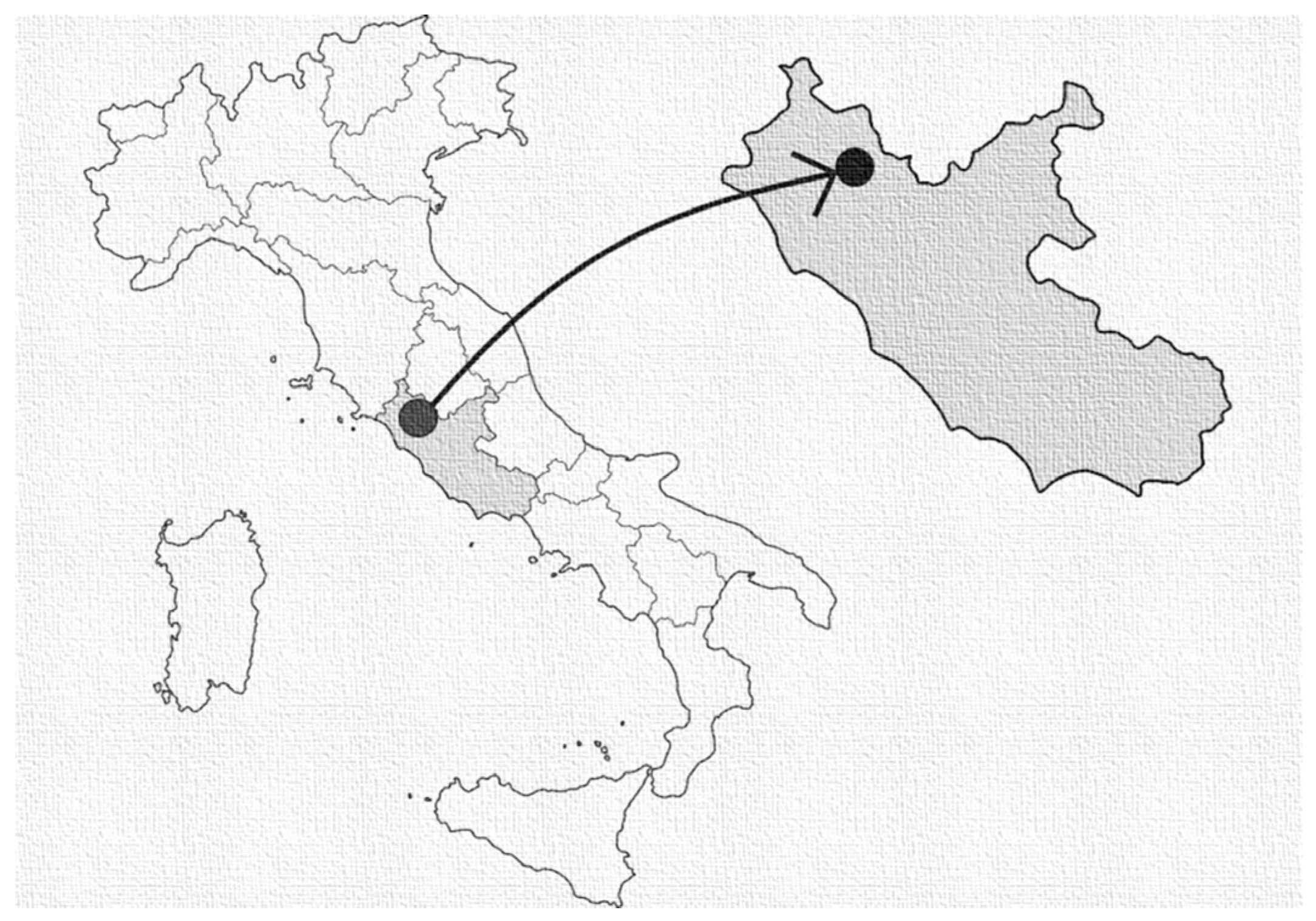
Figure 1.
The location of the Bomarzo Cathedral (Viterbo, Italy).

Figure 2.
The location of the two areas of the GPR acquisitions and the orientation of the GPR profiles. Note that the squares on the map indicate the location of the column bases inside the church.
Figure 2.
The location of the two areas of the GPR acquisitions and the orientation of the GPR profiles. Note that the squares on the map indicate the location of the column bases inside the church.

Figure 3.
Example of a radargram acquired in the central nave where a uniform natural stratigraphy is present.
Figure 3.
Example of a radargram acquired in the central nave where a uniform natural stratigraphy is present.

Figure 4.
Example of two parallel radargrams acquired in the left lateral nave where a more complex anthropic stratigraphy is present at a depth of approximately 2 m. Note that, above this presumably anthropogenic structure, there is a layer of soil upon which the church floor rests, which clearly attenuates the electromagnetic signal.


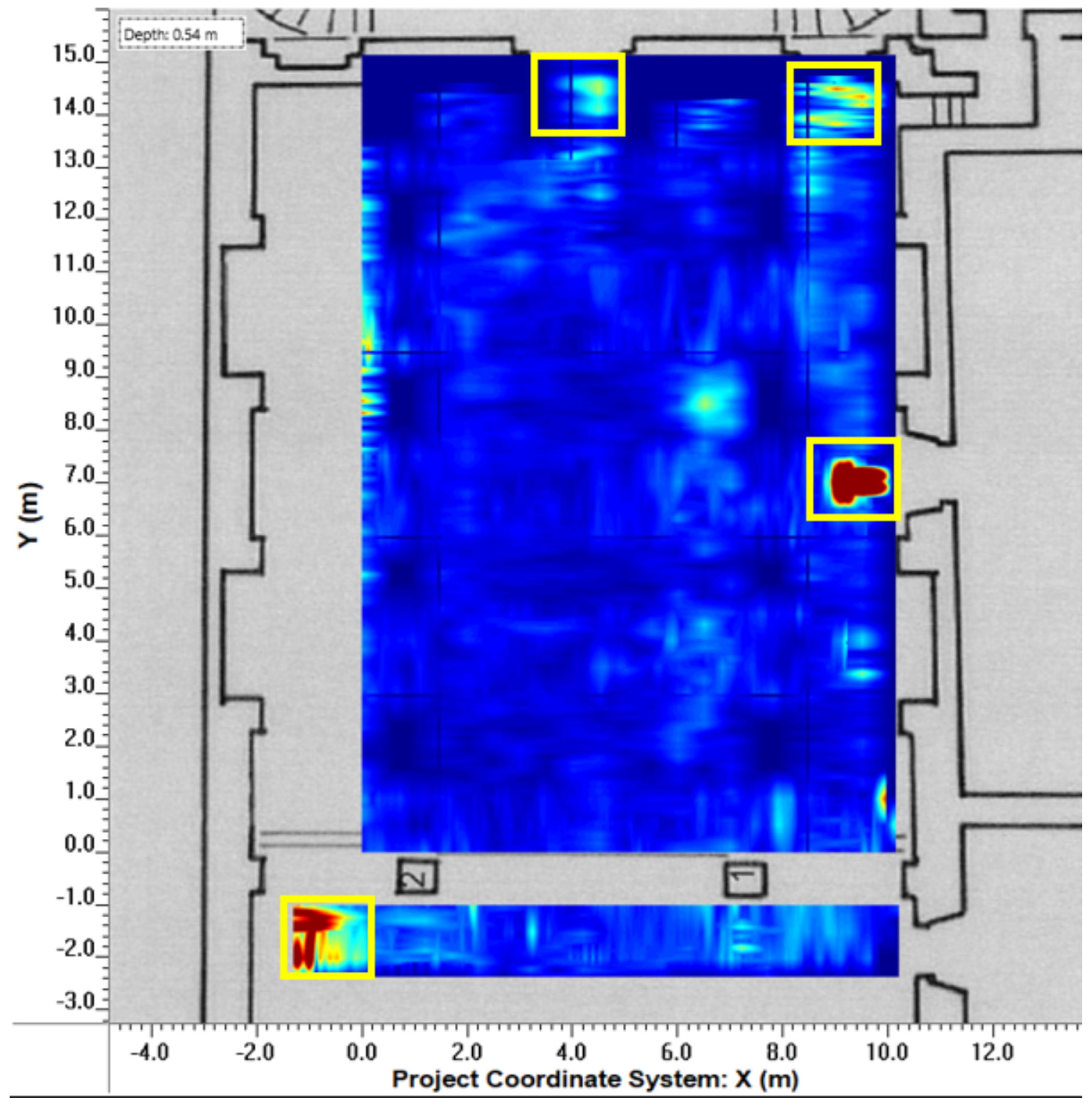
Figure 5.
In the depth slice, at a depth of approximately 0.5 m, four rectangular anomalies (highlighted in yellow) can be observed. These anomalies are relevant to possible artificial chambers, possibly used for burials. Specifically, one anomaly is located at the beginning of the left lateral nave, another halfway along the left lateral nave (also noticeable on the surface), one at the beginning of the central nave just at the entrance, and one in the right lateral nave beneath the minor altar.

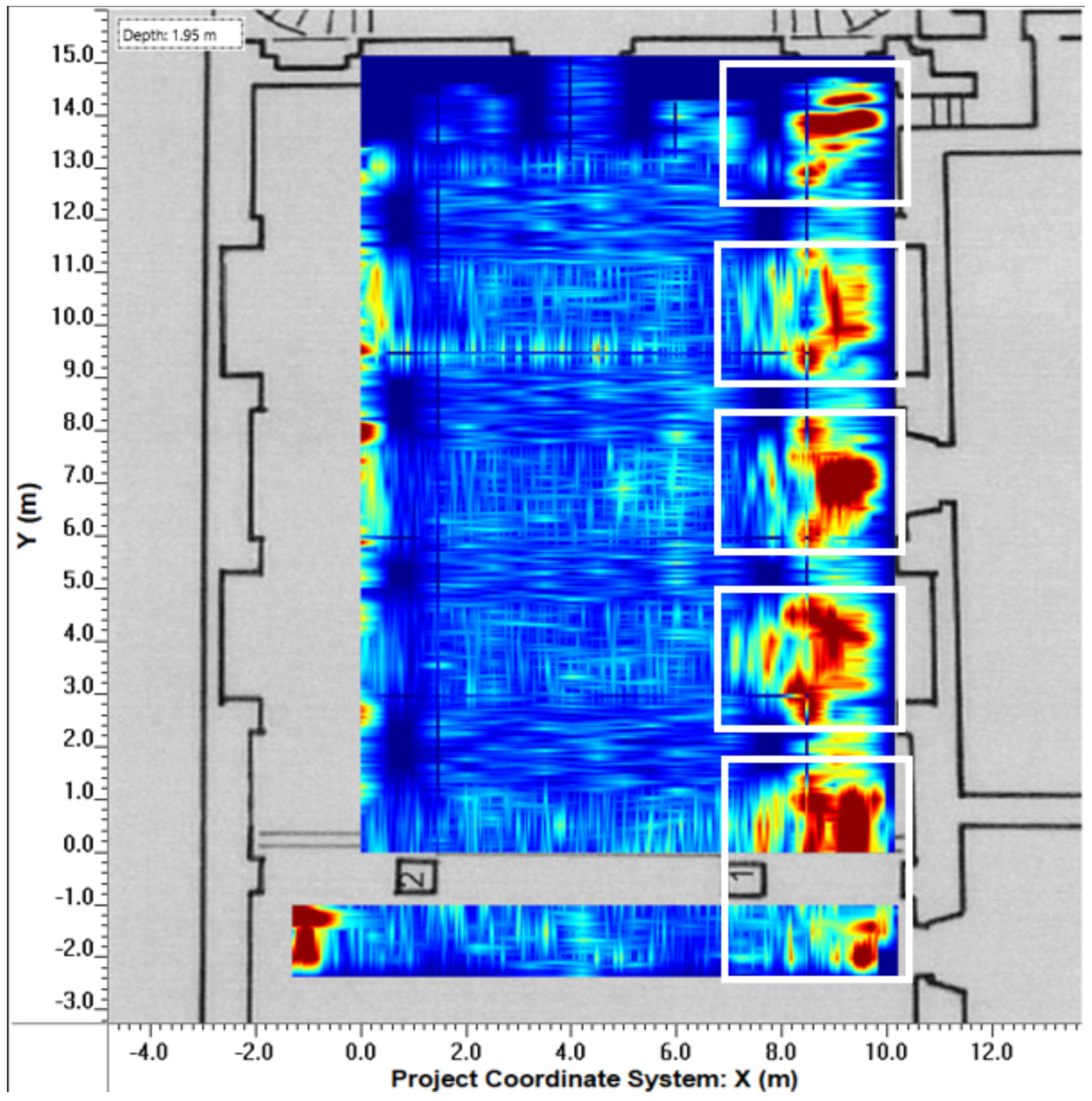
Figure 6.
In the depth slice, at a depth of approximately 2 m, five elongated anomalies (highlighted in white) can be observed beneath the floor of the left lateral nave. These anomalies are of substantial size and appear to correspond to artificial foundations similar to those present beneath the right lateral nave, which are also visible from the exterior of the church.

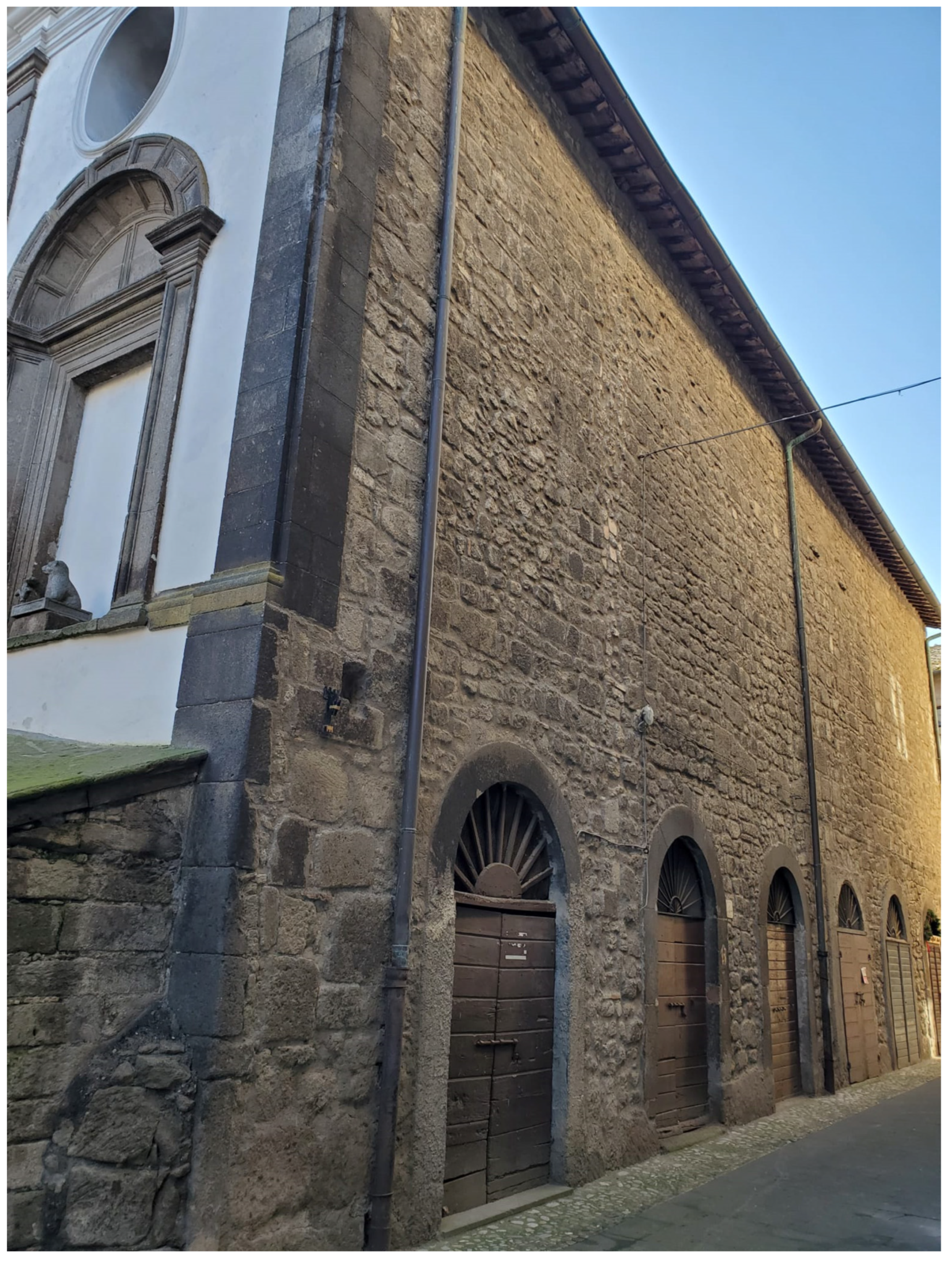
Figure 7.
The barrel vaults system supporting the right lateral nave of the church. This system is the only one visible from the exterior and is also partially detectable in the GPR results in Figure 6. Based on the GPR results beneath the left lateral nave, it is presumed that the same structural system has been replicated.

Figure 8.
Reconstruction (on the top-left) of the possible symmetrical and vaulted anthropic spaces (highlighted in brown) built to support the church at a depth of approximately 2 m, based on the pseudo-three-dimensional reconstruction of the corresponding anomalies (on the right). In the center of the top-left reconstruction, the area beneath the central nave is highlighted in green, presumably composed of a natural tuff rock block.

Disclaimer/Publisher’s Note: The statements, opinions and data contained in all publications are solely those of the individual author(s) and contributor(s) and not of MDPI and/or the editor(s). MDPI and/or the editor(s) disclaim responsibility for any injury to people or property resulting from any ideas, methods, instructions or products referred to in the content. |
© 2023 by the authors. Licensee MDPI, Basel, Switzerland. This article is an open access article distributed under the terms and conditions of the Creative Commons Attribution (CC BY) license (https://creativecommons.org/licenses/by/4.0/).
Share and Cite
MDPI and ACS Style
Barone, P.M.; Lamoratta, G. Unveiling the Hidden Secrets of Bomarzo Cathedral: New Evidence from Last Ground-Penetrating Radar Survey. Heritage 2023, 6, 7578-7588. https://doi.org/10.3390/heritage6120398
AMA Style
Barone PM, Lamoratta G. Unveiling the Hidden Secrets of Bomarzo Cathedral: New Evidence from Last Ground-Penetrating Radar Survey. Heritage. 2023; 6(12):7578-7588. https://doi.org/10.3390/heritage6120398
Chicago/Turabian StyleBarone, Pier Matteo, and Giovanni Lamoratta. 2023. "Unveiling the Hidden Secrets of Bomarzo Cathedral: New Evidence from Last Ground-Penetrating Radar Survey" Heritage 6, no. 12: 7578-7588. https://doi.org/10.3390/heritage6120398