Article

Heritage Building Information Modelling Implementation First Steps Applied in a Castle Building: Historic Evolution Identity, Data Collection and Stratigraphic Modelling

by
Alcínia Zita Sampaio
1,2,*,
João Tomé
1 and
Augusto M. Gomes
1,2
1
Department of Civil Engineering, Higher Technical Institute, University of Lisbon, 1049-001 Lisbon, Portugal
2
CERIS—Civil Engineering Research and Innovation for Sustainability, 1049-001 Lisbon, Portugal
*
Author to whom correspondence should be addressed.
Heritage 2023, 6(10), 6472-6493; https://doi.org/10.3390/heritage6100338
Submission received: 28 June 2023 / Revised: 7 September 2023 / Accepted: 8 September 2023 / Published: 22 September 2023

Abstract

:
This research presents an application of the Building Information Modelling (BIM) methodology to the preservation of buildings of historic value. The study of the built heritage encompasses several aspects: namely, the collection of information, the rigorous representation of the building, the identification of the applied traditional construction processes, and the classification of historic eras of construction, conservation or refurbishing. In a BIM context, the topic of old buildings is referred to as Heritage Building Information Modelling (HBIM). In order to illustrate the type of work that needs to be prepared, a building heritage case is presented. The study is focused on the identification of the historic evolution of a castle and the adjacent structural environment. The first step concerns the data collecting: several institutional repositories of old documents were consulted; technical visits to the site were performed; a large photographic survey was undertaken; and photogrammetry technology was applied. Based on the available information, the corresponding stratigraphic HBIM model of the historic complex was generated, which was associated with an accessible and well-organised database. This text aims to contribute positively to the dissemination of the HBIM in the preservation of historic buildings, and it is focused on a mandatory first step: generating a complete stratigraphic HBIM model. The model is intended to be a useful support to professionals to elaborate the preservation project, as it archives relevant data. The description of all processes from the data collection to the stratigraphic model brings an important understanding of the relevance of a primary stage performed with depth and care. This research contemplates, essentially, the topic of collecting data as essential to the performance of heritage studies.

1. Introduction

The application of the Building Information Modelling (BIM) methodology is mostly focused on new building design, construction and management. However, existing buildings need attention, such as in works of conservation, maintenance, preservation, repairing, retrofitting, restoring and rehabilitation. In relation to buildings of historical or heritage value, the intervention work to be carried out around these cases requires very detailed data collection support and the involvement of a multidisciplinary technical team. An intervention in historic buildings encompasses distinct types of processes requiring the input and collaboration of professionals with very different skillsets. In this context, Heritage Building Information Modelling (HBIM) becomes a useful methodology to fulfil the needs of all specialists, as it allows to incorporate, in a virtual BIM model, information concerning the as-built construction stages, as well as the posterior phases of demolishing, reconstruction or reconversion [1]. An HBIM project concerning the protection, conservation and restoration is becoming common practice, and it is carried out due to the general growing interest in the preservation of cultural and social heritage using digital technologies.
Historic buildings are the outcome of processes of modification and stratification occurring over decades or even centuries. The retrieval of archival documents and the identification of building phases of constructive components are important for an historic–critical analysis, as these elements are witnesses of cultures, events and actors occurring over time [2]. HBIM enables professionals to understand, document and virtually reconstruct the built heritage [3].
An HBIM model allows the presentation of a closer correlation between the 3D model and the digital archive data obtained from a wide information collection. The generation of HBIM models with a rigorous current configuration, associated with a historic evolution identity, is supported in technologies such as remote data report, laser 3D scanning, drone image capture and photographic surveys taken inside and outside the existing building [4]. The data collection process must come from the original building to its complete state of construction, going to the processes of partial demolition, reconstruction and identification of the applied materials and traditional construction techniques.
Disseminating detailed and accessible information about the built heritage is fundamental to understanding the value and meaning of the heritage within the society. Over the years, the buildings have been submitted to various environmental phenomena, different types of occupation or even distinct repair or remodelling works [5]. An antique building entity covers all of these actions and constitutes a living repository of the human action. The heritage entity refers to the traditional construction processes applied in the light of the knowledge of the materials’ resistance behaviour, the striking architectural trends of each epoch and the history of occupation, with a direct implication on the inner structural reorganisation and on the eventual space enlargement of the initial volume of the building [6].
The database of the HBIM model, generated in each case, can be easily accessed, supporting the retrieval of the information required for preservation studies. The great organisational capacity of an HBIM model database brings a range of benefits in visualisation, structural and conditional monitoring, training and research for conservation practice [7]. Generating the 3D parametric BIM model with plenty of rigour and detail provides a holistic view of the building and facilitates the preparation of conservation works along with efficient communication within the multidisciplinary team [8]. A heritage building intervention requires a careful quantitative and qualitative survey to estimate the costs of the entire project work. The as-built BIM model presents a potential for enhancing the quality of heritage building designs, as it provides an agile platform for engineers in preparing cost estimation for the conservation of heritage buildings [9].
Recently, the potential of HBIM has been greatly explored, contributing to the recognition of the methodology as an important support to the preservation of buildings of heritage value. However, the BIM implementation in this area is still in an early stage of adoption. Most of the recent HBIM reports are mainly oriented toward the creation of new libraries of parametric objects used in the modelling process in order to obtain realistic configurations. Concerning the generation of adequate specific parametric objects, Murphy et al. [10] reported as a first step the consultation of historic documents in order to establish geometric rules to be replicated in the definition of new families of antique architectures. López et al. [3] mentioned as a fundamental and actual research topic the generation of a rich HBIM library supporting the modelling of monuments and antique buildings. Currently, such innovative and advanced technologies as scanning equipment and photogrammetric surveys have been applied. Following Kamaruzaman and Solihin [11], modelling architectural details can be supported on the captions of 3D point clouds, allowing the identification of new parametric objects by converting surface meshes.
In order to illustrate the required data collection step, a study case was selected. The practical methodology began with a brief description of the main data collection procedures, which was followed by a report of the strategy to define a stratigraphic HBIM model. The present text describes all relevant stages of the study, which are essentially oriented to reveal the difficulty and necessity of collecting the data that are normally required in a heritage study. The preliminary step involves the consultation of professionals involved in the preservation of the case study, which is followed by the chronologic statement of all events concerning the occupation and the associated rehabilitation works that were performed. The principal innovation and the most positive contribution of this research is the development of a deep and detailed data collection method, with sufficient rigor to support the generation of an accurate stratigraphic HBIM model associated with all the retrieved data and old documents. A large number of new parametric objects were also defined for the present study case, with the intention of enlarging the available library for heritage cases.
The main objective is to define properly a first step contributing positively to HBIM implementation in the heritage construction sector. Frequently, this stage is not completed with sufficient depth, introducing misunderstanding into the general understanding of the problem (historic evolution and demolition/reconstruction stages) to be resolved by the heritage expert team (architects and engineers). If this step is well organised and the quality of the research is adequate, the collection of manuscripts, drawings and all type of information required in a heritage procedure is conveniently supported. In addition, based on the collected data, it is possible to create a useful, high-quality stratigraphic BIM model.
In the present case, the main objective was to organise, in a digital way, all the documentation that was possible to obtain, following the standards required currently in the construction sector. In all processes of retrieving antique documents, the involvement of several City Hall professionals of Faro (Portugal) of the heritage preservation sector was essential, beginning with a very important oral transmission that helped to define a well-planned strategy of how to obtain relevant data used later to compose a correct stratigraphic model. If the City Hall were to do similar work near other antique buildings that compose the cultural heritage of the city, the institutional experts would have good supporting information (digital, organised, visual and accessible) to study and better plan eventual preservation works, with requirement and cost estimations. That was the main practical objective of the study. The other objective is academic and refers to improving and disseminating knowledge about how to initialise the implementation of an HBIM.

2. Background

An HBIM model represents, naturally, the 3D geometry of the building, with an adequate rigor, but it also must incorporate all the collected heritage information and archived documents. The database of the model can be used to deal, in an efficient way, with the tasks of historic documents management. The HBIM concept has been explored in a historical context but also in the preparation of documents and images in the conservation or retrofitting of buildings of heritage value:
  • The HBIM parametric model, concerning specific architectural elements, can be adapted as needed. However, the available library of current BIM software presents some limitations, and there is a lack of antique architectural elements required in the modelling of historical buildings. The time and effort required for modelling increases with the complexity of the building and the volume of particular details of the house. The buildings belonging to eras where construction standards start to develop, namely from the late nineteenth century and early twentieth century, could benefit from the creation of libraries of parametric objects for those specific construction types and components [12].
  • The creation of a library of elements focused on antique architectural configurations contributes to the dissemination of the HBIM. In it, manual and semi-automatic modelling methods can be considered, focussing on aspects such as the as-built level of development (LoD) from the architectural and engineering perspectives [13]. Concerning HBIM, some aspects are normally considered, namely, model workflows of extracting information, the level of development (LOD) of the generated models and the regulation of the stakeholders’ participation in the conservation or retrofitting design [14]. The LoD level required depends on the characteristics of the building and the objectives of the study. A detailed model of level LoD 400, which reproduces as much as possible the geometric irregularities of the building and enriches by the maximum quantity the information available, is required in the HBIM context [9].
  • The interior geometric forms of antique or historic buildings can include brick vaults, frescoes, stucco and decorations, with a great variety of solutions. Starting from laser scanning, photogrammetric and thermographic techniques, the reconstruction process of the geometry and construction techniques allows for the recognition and understanding of the construction richness, the multiplicity and uniqueness of each architectural element, made of recurrent elements and specific features, forming specific libraries of new parametric objects [15].
  • The use of advanced technologies on image capture is a recurrent strategy in order to obtain accurate configurations supporting an efficient modelling process [16]. Current BIM platforms are able to explore workflows for automatically analysing point clouds and generate specific HBIM libraries. The parametric objects, and in a general way, the new families of objects, must be complemented by a typology classification and the identification of material constitution [17]. Some of the reported works aim to overcome the challenges of modelling existing buildings with insufficient or pre-existing documents [18] as well as addressing the relational complexity of information in a BIM context [19].
  • The innovative technology enables a 3D representation of buildings while taking into account shapes, dimensions, conservation states and hypothetical transformations in time [20]. The technological innovative solutions have been applied to convert HBIM models into 3D representations suitable for portable devices for the purposes of virtual tours (VR) and augmented reality (AR) [21].
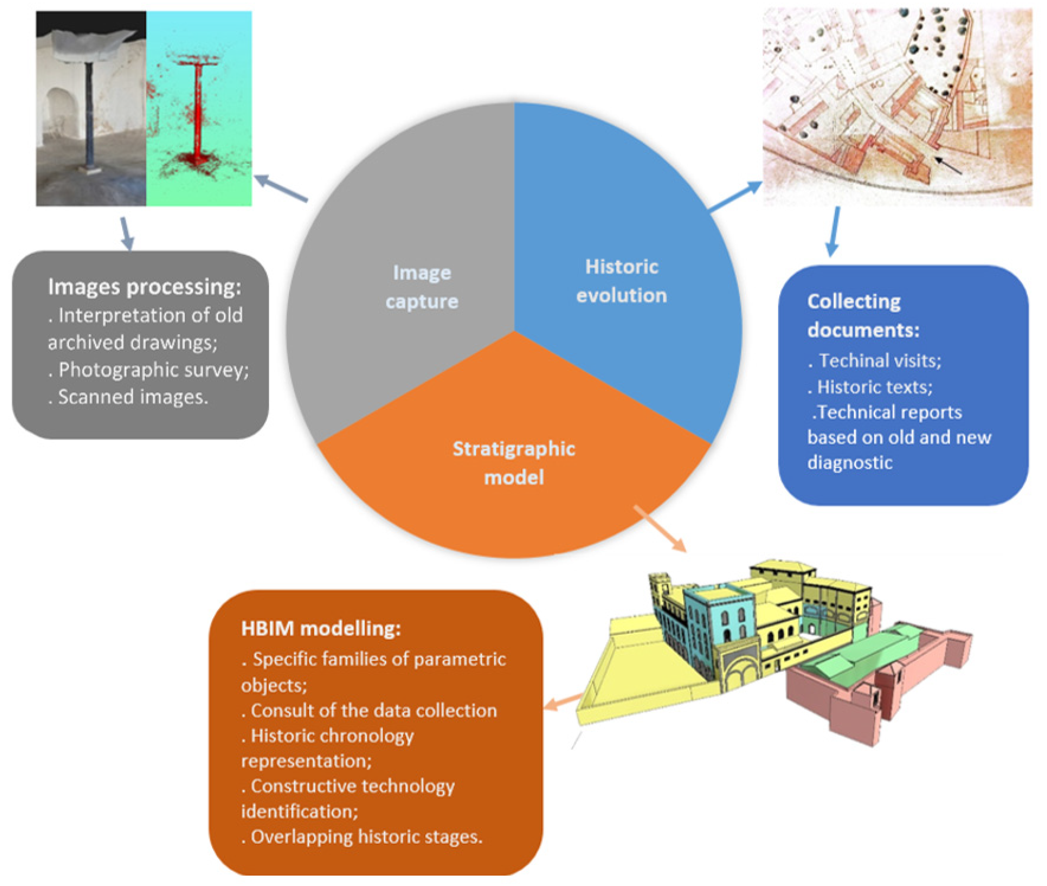
  • To initialise the capture process of antique documents and images, specific tools and equipment related to cultural heritage processes are needed, focused on the organisation and coordinated storage and management of historical data. This first previous step allows professionals to perform an easy analysis and query, on time management, supporting the generation of 3D geometric models of irregular shapes, flexibility and user-friendliness [19]. The image capture work is frequently supported on photogrammetry technology. A photogrammetric framework comprises the phases of defining an optimal scanning equipment position and of collecting data with an autonomous scanning system. The number of scanning positions and the scanning operation time can be eventually reduced compared with a manual scanning work by skilled surveyors in real-world indoor environments [22].
  • An HBIM model should represent the most natural and modern approach to historical assets management. The HBIM database of the model addresses the historical heritage field and must be kept updated and customised concerning all components, which is required to support the elaboration of projects concerning the preservation or rehabilitation of old buildings [23]. The database provides advantages in documentation retrieving over time and the identification of different construction phases, allowing to centralise all databases related to the building in analyses. The model database is made available in web-sharing platforms in order to support the development of tasks related to maintenance programs, structural analysis or VR/AR applications [24].
  • Following the most recent technological advances that can be applied to support the engineers to realise their local inspection works, a great range of equipment can be applied (destructive and no destructive). Some non-destructive testing tools are ground-penetrating radars, impact echo tests, infrared thermography inspections, in-situ surface absorption tests, in situ carbonation experiments or surface rebound hammer examination. The destructive methods are normally only used on advanced stages of the heritage study process in order to evaluate the building security performance. The tools currently used can be applied to find the exact points where the buildings, materials, or components fail, and they are mainly based on stress analysis tests and the evaluation of the mechanic levels of material deterioration.
  • In order to initialise the collecting process, it is necessary to study, list and described the distinct solutions available that can be used on the this first procedure. Therefore, the present text inserts a basic research concerning this first step, and after some required strategies were then applied, focused on the analyses of a heritage building case. In addition, as the present case is a castle complex, where the required preservation studies must be performed, the text intends to expose how the HBIM methodology can be applied and the aspects that must be worked out to conceive an adequate support for the preservation expert team.

3. Materials and Methods

The main requirements in using HBIM for representation and surveying the historical architecture is the quality of the model and its reliability regarding the geometry. A second condition involves the addition of a comprehensive database of the historical notes concerning each component about materials and changes over time. An HBIM study must meet these requirements in order to play a key role in the representation of a cultural built heritage [25]. The creation of an HBIM database that addresses the field of historical heritage and keeps the model components updated and customised is important to make it as usable as needed and required in an heritage study [26].
An HBIM process initialises with the collecting documentation step, which is the necessary action that supports the modelling process and the data organisation required for heritage projects. The potential of HBIM, as a centralised data platform, facilitates the production, integration and management of the essential information within a heritage building study. The basic data to be first collected include paper drawings and digital documents, identification of the applied material and knowledge about traditional construction processes as well the sequence of as-built construction steps and historical context information (Figure 1).

3.1. Problem Statement

The BIM procedure can be extended, conceiving well-organised strategies and modelling parametric requirements, to be applied in the management, preservation, reconstruction, renovation or restoration of heritage and historic buildings. The geometric and descriptive information about the real configuration of the building, as well the existing technical drawings and old text documents, must be first collected. In the last decade, several historical objects were documented using modern methods, such as photogrammetry and laser technologies, to obtain benefits from the economy, safety, presentation, and life-cycle management of historic buildings. Therefore, an important and early stage concerns the data-collecting process.

3.2. Scope of the Study

The study is mainly focused on the initial step required to later perform a rigorous generation of a stratigraphic HBIM model in geometric configuration and information. A first visit to the real building space was made, and it was accompanied by professionals of the historical and archive sectors of the Faro Chamber, allowing us to define an adequate working plan for the data-collecting stage. A first identification of the construction stages is essential to define a posterior correct stratigraphic 3D representation of the heritage building, following the diversity of occupation type of the building complex. In this research, some of the most available advanced technologies of data capture were used. In addition, several new parametric objects were created in order to generate an adequate library of parametric objects for the present case. The archive of data and documents in the database of the generated HBIM model is an aspect studied and resolved as required to achieve an adequate LoD level: the 400.

3.3. Main Contributions

The main contribution of the present work is to provide evidence regarding the importance of conceiving a suitable strategy concerning the data collection step. The resources and processes applied on the study case were, mainly, the realisation of local technical visits, collecting old drawings, consulting books and texts about the building historical context, identifying the components of the building associated with each distinct occupation type of the building complex for ages, and the obtained recourse using photogrammetry equipment and a large photographic survey. Based on the analyses of all the collected information, a stratigraphic HBIM model was created, forming the second main aspect that was carry out from the study. The principal remark worked out from the study is that the collecting phase must be correctly planned and executed. The second note concerns the capacity of data organisation, allowing easy access to all information and an illustrative visualisation of the historical evolution of the building represented in a stratigraphic HBIM model form.

3.4. Objective and Achievements

The study considers the topic of collecting data as a necessary step that must be performed with a suitable plan and depth. This stage is difficult to execute efficiently. This stage initialises with the consultation of professionals involved in the preservation of the case study, followed by the chronological statement of the identified events, concerning occupation, demolishing and rehabilitation. The innovation and the main positive contribution lie essentially in three aspects: the realisation of this preliminary work; the generation of a correct stratigraphic HBIM; and how to archive all the documents in an accessible way in order to allow professionals to consult the collected data when required, supporting the preservation or rehabilitation studies.

4. Collecting Documents

The document-retrieving phase is considered as the first stage in an HBIM project. It is the process of collecting all the available information for the current conditions of the building from various sources. The relevance of the information may vary according to the quality and quantity of the existing data found for the building. Professionals involved in the project use the HBIM model as an archive and an information resource, allowing the management of data, geometric (visual representation) and non-geometric (paper drawings, photographic survey or text reports).
Heritage buildings are iconic and symbolise the background of a country in both historical and cultural contexts [7]. In it, HBIM is set to play a key role as a digital repository of the heritage building in analyses, as it can combine quantitative and qualitative data and facilitate the integration of different stakeholders. The HBIM model contains specialised digital data of interest related to the different phases established along a heritage process [27]. The BIM software became a recurrent platform of 3D modelling, archiving documents and manipulating data as a support to the development of heritage projects. The complex modelling process of a heritage building, with a high severity, involves the representation of the architectural elements and particular details, according to artistic, historical, and constructive typologies.
The close connection between the representation of the building construction technology and the sources from which it is derived leads to the quantity and quality of the collected documentation [3]. The rigorous modelling of the configuration of an existing building can be supported by the use of digital equipment such as 3D laser scanning, drone images and photogrammetry processing. However, the first step must be retrieving, from institutional organisations (municipal archives, museums and antique repositories), the available old technical drawings (plants, elevations and sections) and texts (inspection reports, projects of eventual retrofitting or reconversion works, and manuscripts describing the type of occupation in a historical context):
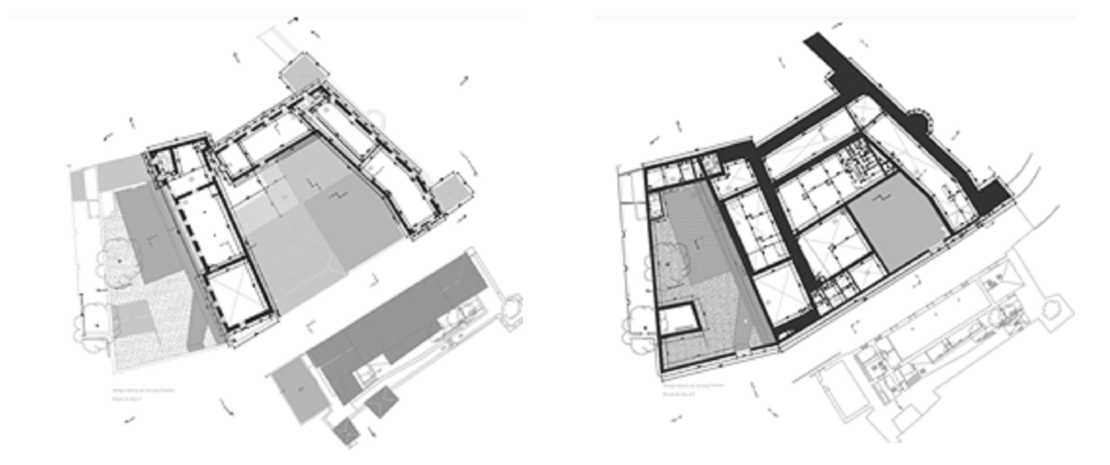
  • Archived drawings: The availability of detailed 2D documents for heritage buildings is often limited due to the difficulty of the full coverage of the building’s details. The drawings of the heritage buildings are difficult to be retrieved due to data being scattered. The creation of an initial HBIM model requires, as a first step, a careful interpretation of the old drawings. Frequently, the drawings found in municipal archives include yellows and reds, helping to identify changes in the building over time;
  • Reports and historic texts: Collecting the available written documents can help enhance an adequate understanding of the knowledge and design transformation processes associated with the heritage building. The HBIM model is meant to be an important repository platform of the building, including its historical context, statement of construction adjustments performed over time, reports of eventual actions of preservation or the detection of anomalies stated in texts and photographic surveys;
  • Three-dimensional (3D) laser scanning: Data collection considers the 3D scanning data capture, which is a fast and reliable digital survey technique [10]. It can be applied by the interior and exterior of the building spaces. When a point cloud file is obtained, it is after imported from BIM software where the application of specific analytic algorithms allows conceiving a 3D parametric model based on the use of the new object related to a specific architectural epoch. In the last few years, the laser-scanning equipment has achieved considerable advances, improving the data quality collecting of old architectures, by the increase in the speed of data capture and the reducing of noise elements [28];
  • Drone: The images’ data processing and the related analytic algorithms allow users to perform a set of photographic on aerial image data collected, representing the geometry of the entire building by the exterior. The drone capture method is useful for situations where performing architectural surveys, using traditional equipment, is time-consuming or even impossible to realise, such as in high roofs. It is also essential to have proper weather conditions and homogeneous lighting;
  • Photogrammetry: The image survey can be obtained inside and outside the building in analyses, performed in a ground based or aerial work, saving time in the field, while proving to be extremely accurate at registering non-regular geometries of buildings [29]. It is a suitable survey technique to be used on buildings of high complexity of architectural detail. However, it is necessary to ensure that all geometry is captured by images with enough information overlap and to avoid large jumps between photos [30].
The creation of an HBIM model is initially supported on the interpretation of the retrieved old data collected in public institutions and then complemented with digital data captured by a depth survey based on the use of 3D scanning, drone or photogrammetry equipment. Depending on the availability of the information, parts of the building can be better defined and parts can be more unknown. In addition, in order to know the construction technology applied along distinct historical epochs of the building, a previous work oriented to identify the historical context must be performed. It involves retrieving archived documents, diagnostic reports and comparison analyses with similar buildings in age and characteristics.
The main objective of the present work is not related with eventual interventions to be performed over the building, namely refurbishing, maintenance or reconstruction, but it is oriented to the collecting of the data phase. After having completed this part, the City Hall professionals of the heritage sector can deliver the stratigraphic HBIM model associated to all collected information to professionals of the eventual next steps.

5. Castle and Adjacent Structure

The selected case study is a complex of heritage interest located in the perimeter of the old historical area of Faro, Portugal, known as Vila Adentro [31]. The building is part of the collective and individual memory of the citizens of Faro, having witnessed several interventions and becoming aware of numerous attempts at several reworking studies. The main purpose of the present study is to establish a correct, massive and complete work base, in the form of a virtual BIM model, supported by the information collected and by a rigorous 3D geometric representation.
The structure includes the castle building, the adjacent area adapted to a military storage zone and an old beer factory, named Portugalia, which is one of the first national examples where the innovative construction material, the reinforced concrete, was applied in an industrial building. The global structure follows several historical periods in which the adaptation to new types of occupation, of the castle, the storage place and the factory facility, had a remarkable importance in its current configuration. The collected data cover the knowledge about the associated history, recorded in antique documents, transmitted verbally, and identified from the architectural details of the present configuration.

5.1. Data Collection Procedure

As a first action, professionals with responsibilities within the heritage department of the public institutions were contacted. They provided an easy access to private archived documents and to the inside place of the building complex. The applied data collection activity included several technical visits and the retrieving and consulting of old documents: namely, technical drawings, publications of historical interest, reports of intervention projects and a large photographic survey.
  • The first technical visit to the local site was conducted under the guidance of an expert with responsibilities in the conservation of heritage buildings, Jorge Manhita, a historian of the Division of Museums, Archaeology and Cultural Heritage of the City Hall of Faro. The oral exposition of the expert helped to conceive a first understanding of the constructive evolution in a historical context. The visit constituted an important base to an adequate perception concerning the metamorphoses, physical and functional, that occurred over years through its history and existence. The distinct occupation performed over the years always led to some kind of intervention, whether of expansion, adaptation, preservation or maintenance, reached to the present day. This type of knowledge helped to structure the historical stratigraphy, supporting the generation of the HBIM model of the heritage building in analyses. Numerous visits to the building were executed in order to carry out a photographical survey of the architecture in a general view and with great detail regarding the most relevant identified stonework. The captured images helped to obtain a correct and current representation of the building;
  • Following the suggestion of the expert, distinct documented sources were retrieved from documental repositories of the Municipal Archive and the local museum. The document source initially considered was a set of minute books, with dates between 1924 and 1940, where the most relevant historical events related to the city were recorded. An important collection of old drawings and texts reporting the successive types of occupation of the complex was consulted;
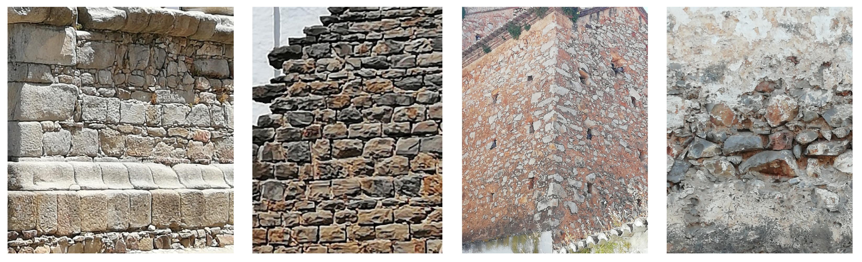
  • During the visits, a large photographic survey was carried out. It was possible to identify various types of material applied as masonry, both in interior and exterior walls. The material of the castle consisted of regular stone appliances (Figure 2). The interior walls, depending of the epoch of construction, presented rolled stones or the innovative reinforced concrete (Figure 2). The photographic images also made it possible to identify several anomalies, complementing the inspection visits that were required to support the analysis of the current state of conservation of the building.
  • In the present case, an additional work concerning the identification of the composition of the walls in order to better classify historic eras and stages of demolishing and reconstruction was performed, as illustrated in distinct photographic sets. Part of the composition of antique walls was easily identified as the finishing material presented some detrition, which allowed visualising the interior composition of some walls.

5.2. Consultation of the Data Collection

All collected data were compiled, consulted and analysed. We established a chronology of construction, demolition and reconstruction phases together with the identification of the respective functionality and historical context:
  • Published documents with relevant historical information were provided and consulted. These documents formed an important base for working within the historical reconstruction and modelling processes of the brewery factory:
    The industrial buildings of the Portugália Beer Factory in the Castle of Faro-Provisional opinion by Jorge Custódio and dated 1995;
    Process of the international competition for the installation of a Contemporary Art Museum project in 2001 by Hartmman and Cid Architects.
  • Other documents registered in 1993 and made available by the department of the Information Systems for the Architectural Heritage (SIPA) added historical and architectural knowledge to the fortress:
    IPA 00001316, Fortress of Faro/urban fence of Faro;
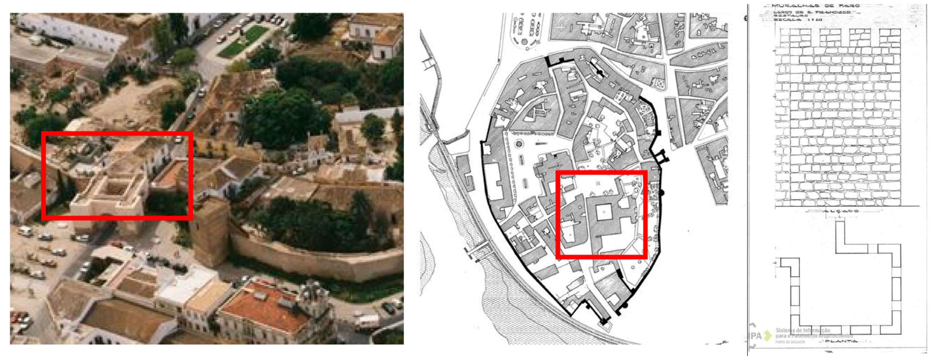
    IPA 00004493, Seventeenth century fence/sixteenth century wall/fortified front of Faro (Figure 3).

5.3. Historical Evolution

The retrospective compilation of historical building information is a relevant aspect to be considered to agile data retrieving within the analyses of heritage buildings. In the present case, based on the collected information, it was possible to identify the main historical epochs, in which there were applied construction interventions related to the diversity of occupation of the building:
  • The castle of Faro, as an architectural structure of fortification, was erected in a dominant position over the soil, close to the communication routes, land, river and sea, with functions concomitantly defensible and residential. Although, at the beginning of the twentieth century, part of the wall was demolished, dividing the castle into two parts for the opening of a new street; it still preserves an architectural identity consolidated over eras, forming one of the last strongholds of southern military architecture;
  • The Arab fortress, dating from the ninth century, was implanted in the extreme south of the current Vila Adentro in a strategic position and close to communication routes, presenting two accesses from the outside;
  • After the Christian reconquest, in the thirteenth century, the Alcazaba is transformed into a castle, having been adjoined, already in the sixteenth century, in the west corner, to an observing tower oriented to the river;
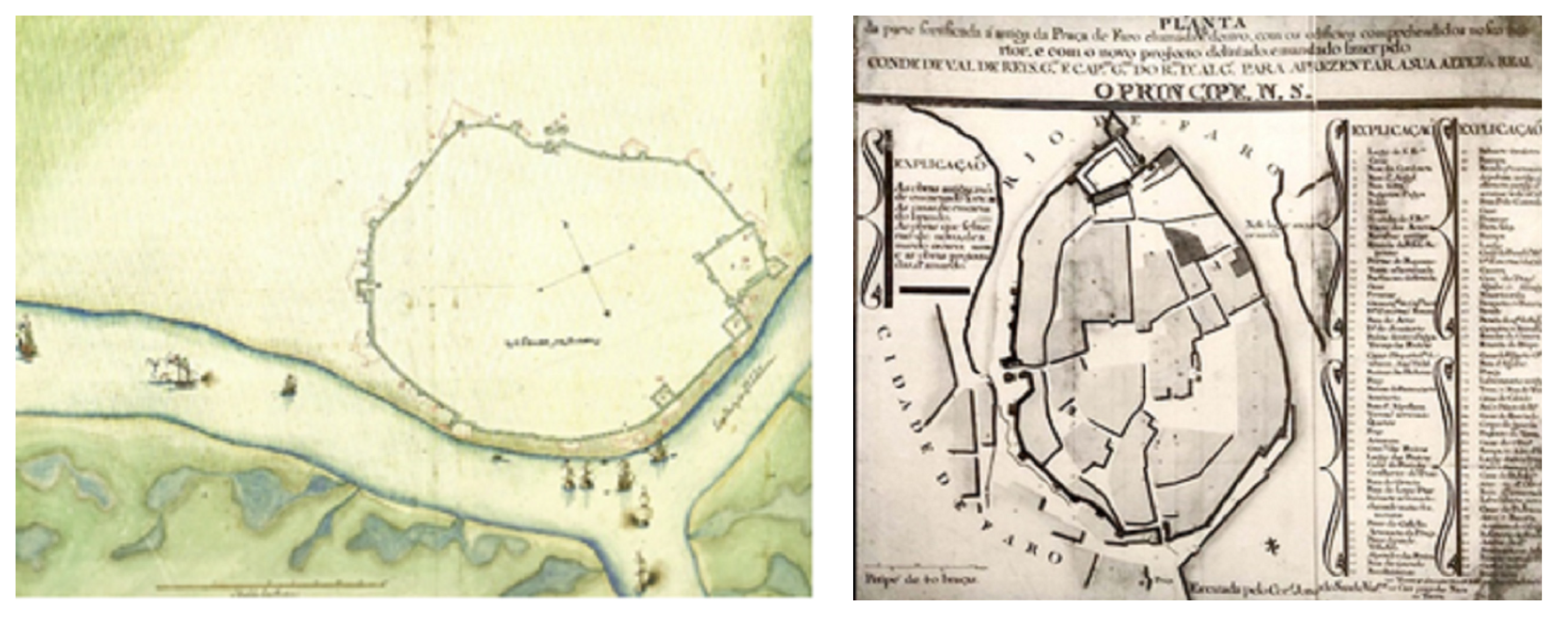
  • An external defensive military structure of the bulwark fortification was reported. In 1620, a first survey, the Codex Cadaval, commissioned by D. João de Castro, was elaborated (Figure 4). From the eighteenth century, a drawing plan of the old square of Faro was requested by the Military Governor of the Kingdom of the Algarve, Count of Vale de Reis (Figure 4).
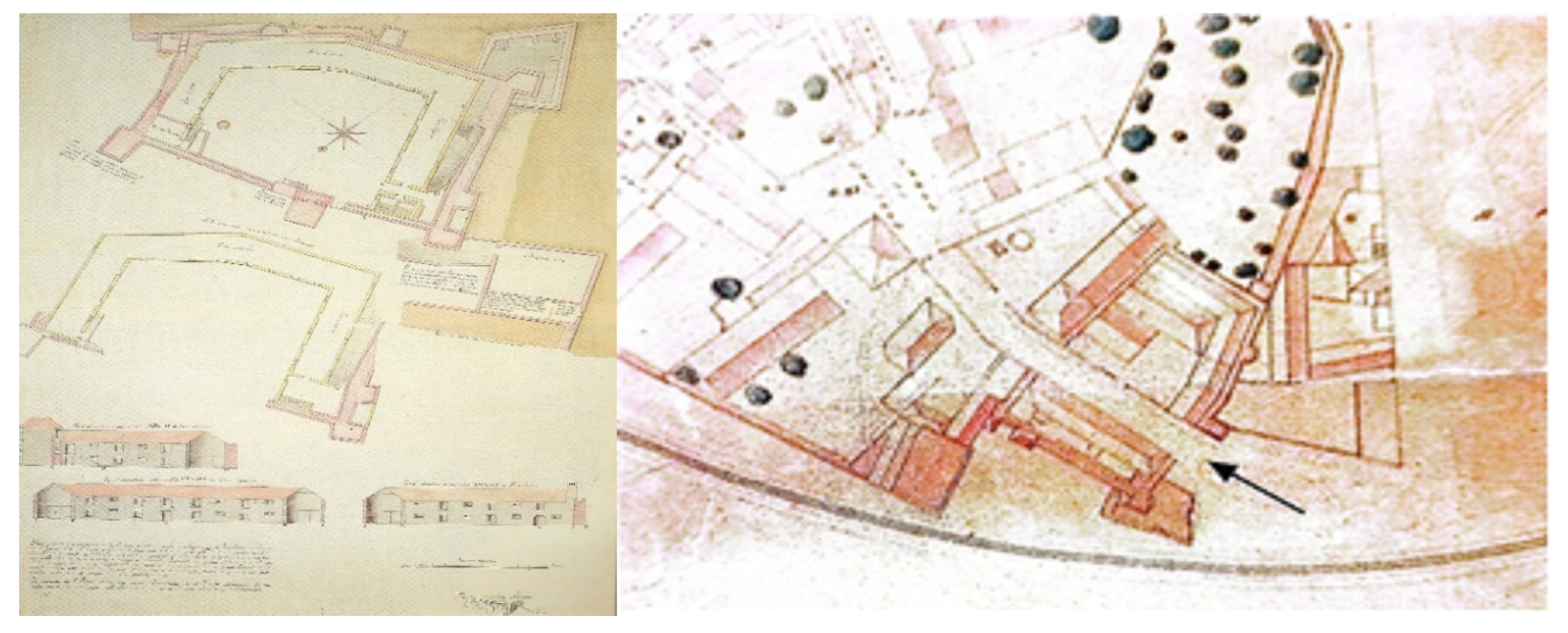
  • The Count of Resende, Governor and Captain General of the Kingdom of the Algarve, ordered the construction of a military quarter to install the Artillery Regiment of the Kingdom of the Algarve. According to the drawings, plan and elevations, dated 1763, the expansion of the castle presents a U-shaped building (Figure 5) adjoined to the east, south and west, and it was composed of three elevated floors in the main building and four elevated floors in the complementary towers.
  • After leaving the military functions, a new phase of industrialisation was initiated in which the army alienated the castle to install, in the southern part, the workspaces of cordage, carpentry, and blacksmithing and in the east the installation of a beer distillery factory;
  • In 1925, the following was decided by the City Council:
    That an avenue be opened bypassing the castle building, from which this Chamber has just acquired (...), as well as a street with the width of ten meters, cutting the area of the said building from north to south.
  • The new opening, effectuated in 1930, introduces a rupture in the urban core, as it eliminates a section of the wall, demolished part of one of the towers of the castle and divided it into two zones, breaking the architectural unity. It then destroyed a section of the north and south walls, introducing a new gateway to Vila Adentro. In a detail of the city plan dated 1931, it is possible to identify the new entrance (Figure 5).
  • The Malt and Beer Producing Company, named Portugalia, acquires part of the land and buildings located on the east side of the new castle entrance, and the required adaptation begins to be performed, between the years 1935/1940, with the construction of the factory and the existent spaces adopted to the new function. This factory marks an epoch, and it stands out over the main built by its height of 18 m. However, the beer distillery factory never came to work;
  • In 1968, the space was occupied by another factory, the Beer and Wine Distribution Society of the South, which is named Cervisul. The Faro Infantry Regiment remained settled there until 1992;
  • In 1999, the City Council reacquired the architectural ensemble on the east side of the castle and the old space of the antique Portugalia beer factory. Since then, several intentions to rehabilitate the space have been studied: namely, the installation of a Museum of Contemporary Art. Currently, there is a strategic and functional program for the requalification of the brewery building, which includes an art and creativity centre and a factory for the production of craft beer.

5.4. Three-Dimensional (3D) Scanned Images

The documentary survey is essential to acquire knowledge concerning the historical evolution of an old building related to the progressive process of construction/demolition and occupation. However, for the rigorous representation of the current configuration of the complex under study, the HBIM methodology often uses a photographic survey, reporting a global view and the detailed stonework, and photogrammetry techniques, complemented with the capture of images through 3D scanning equipment on ground stations or using drones. The HBIM model must incorporate consistent data of the real configuration of the building, forming a complete and efficient database as required on the conservation or restoration works. In the present case, the creation of a specific interior component of the HBIM model, the required heritage asset was performed using 3D laser scanning and photogrammetry. The remote-sensing survey campaign was conducted accordingly and it aimed at a BIM model output, including the process of data alignment, cleaning, and merging.
Photogrammetry is a technology supported on a large set of images obtained around each element to be model, allowing to capture its shape and dimensions. This can be performed through a terrestrial or aerial photogrammetry processes. This technology is agile regarding the use of photographs to make physical measurements, manipulating multiple digital images taken from slightly different angles and containing overlapping information. The images were then harmonised in order to constitute a point cloud, which represent a 3D digital representation of the surface of the object being photographed. The main concept of the photogrammetry process refers to the construction of digital 3D models using photographic images of an existing object to determine highly accurate representations. The generation of a point cloud is carried out after all images are matched and aligned, facilitating the processing of creating point clouds, based on a triangulation procedure, requiring to find common points between the scenes of two camera positions [32].
Currently, it is also possible to use mobile applications allowing the generation of specific clouds related to small volume elements. In the present case, a 3D scanner application was used to take images, in the form of point clouds, based on the photogrammetry method. The applied technology, designed as a KIRI Engine was developed in Hamilton, Canada, and it is licensed by the software company KIRI Innovations Science and Technology Inc. Ancaster, Ontario, Canada [33]. The software can be operated through any mobile device and is available to be used for free. This procedure can be applied to various elements of the building, allowing one to obtain with rigour the correct configuration of the existing elements supporting its modelling process.
As an illustration of the use of the KIRI Engine application, a metallic structural column was selected, which is located on Level 0 of the beer factory. The available equipment, the mobile phone, was initially loaded with the software. Then, different images were captures around the column. After obtaining the point clouds with sufficient volume, the process continued with the manipulation of the collected data in order for the user be able to generate, in Revit software, a new parametric object representative of the element, which is a metallic column of circular section with variable diameter in height. The applied procedure presents advantages in terms of speeding up a correct modelling process of small elements. However, some limitations were also verified during the capture action. The main steps of the process are presented below:
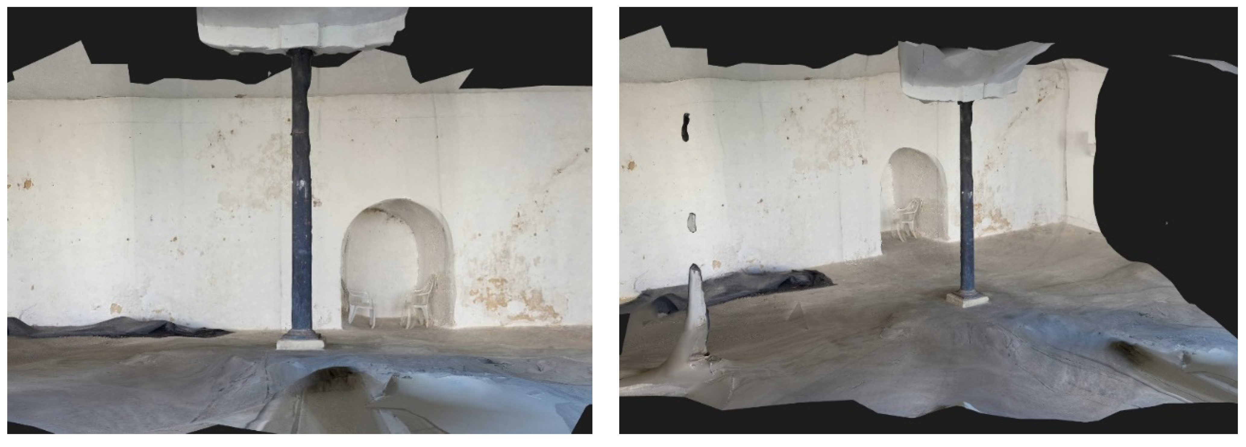
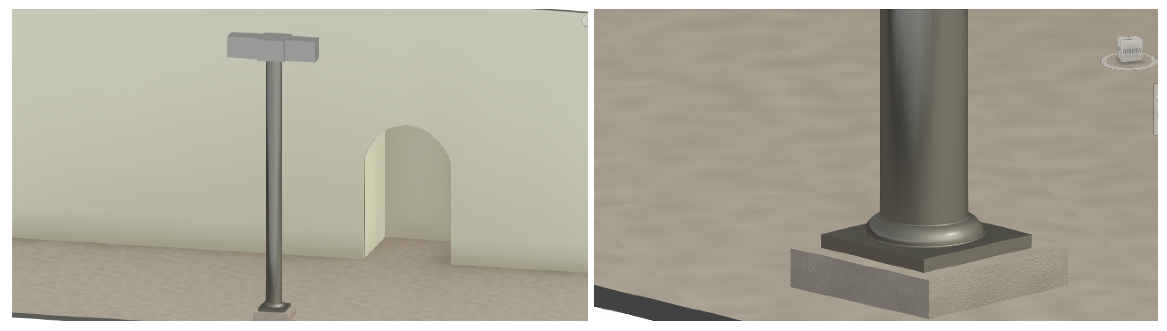
  • The selected column element is located in a space with plenty of natural light, coming from the existing openings in the façade of the factory building, and it is suitable for the execution of a photographic survey, which was carried out with the camera of the mobile phone, with the resolution capacity of 12 Mp (Figure 6). A total of 70 images were captured, which were made from the base of the column (with a particular shape detail) to the top (with a simpler configuration) along about 3.70 m height.
  • Afterwards, the application allows archiving a complete 3D point cloud in the form of a .xyz extension file. Using the plug-in RecapPro (Autodesk), the file is converted into a file saved in .rcp data format;
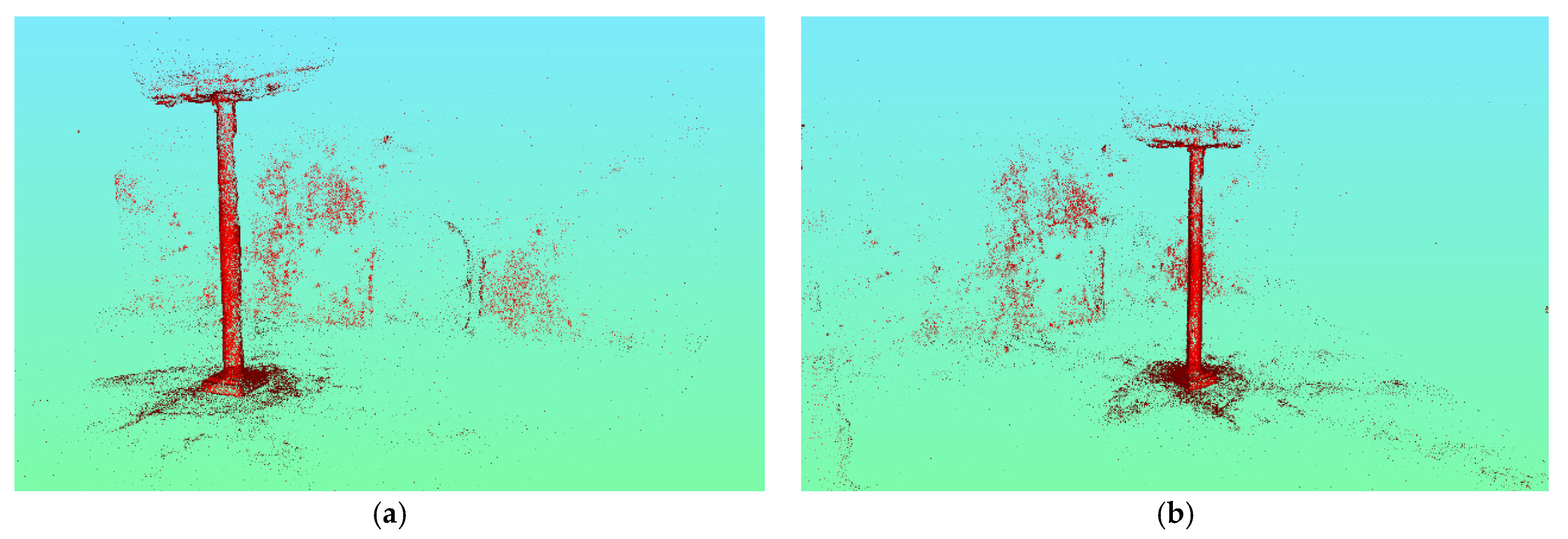
  • The obtained points cloud was then manipulated, having excluded or adjusted some of the points of the cloud when they presented an evident inconsistency, allowing one to reduce the size of the final .rcp file (Figure 7);
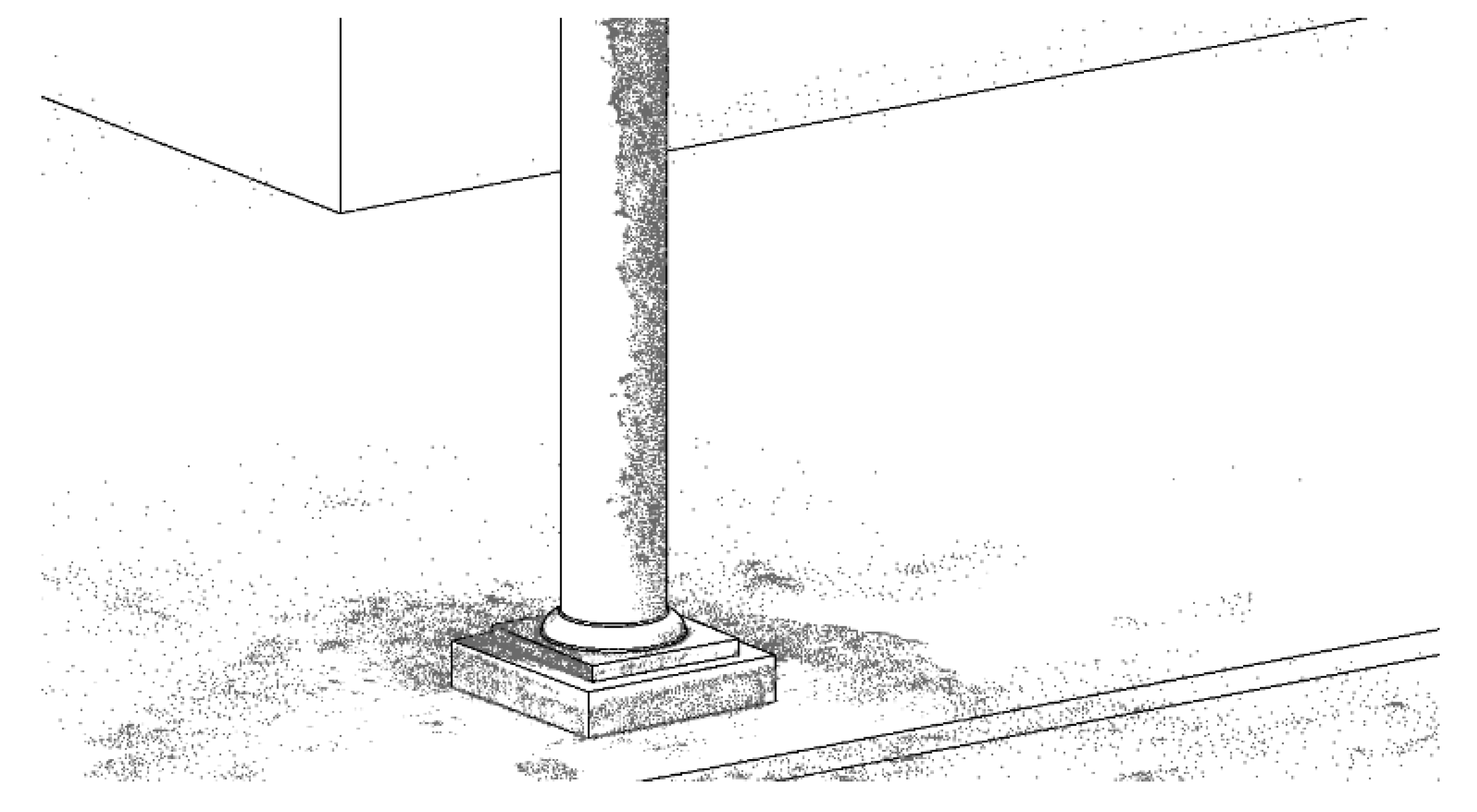
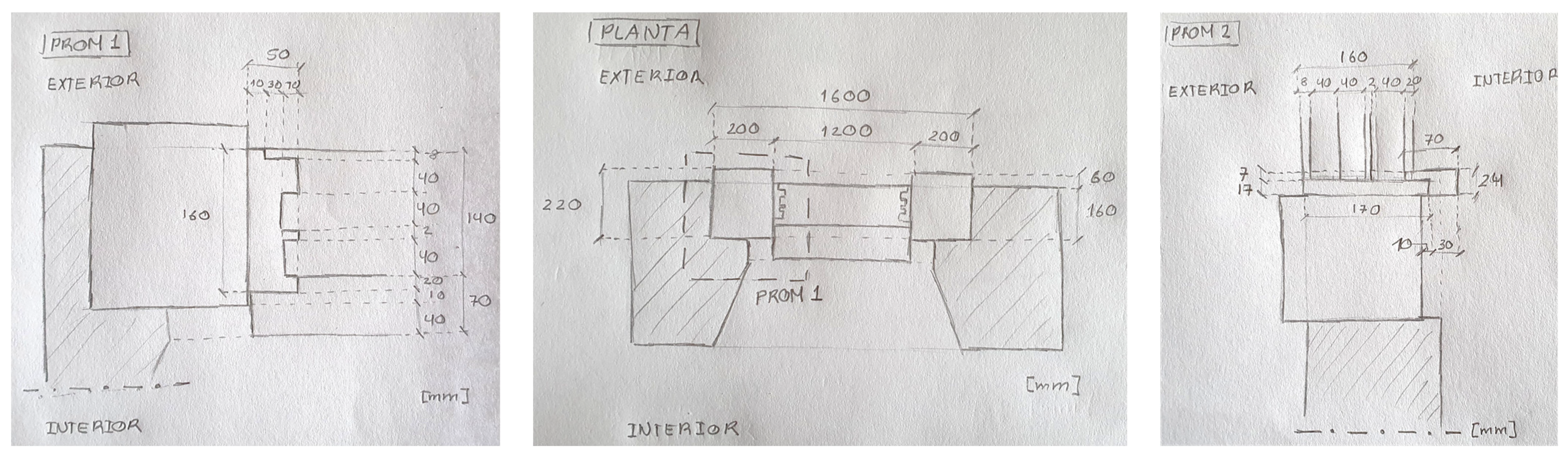
  • The .rcp file is then imported by the Revit software, supporting the generation of a new parametric object, considered as a column family element, to be included in the library of the structural components or as a new family of the present project (Figure 8). At the base and on the face of the column most exposed to sunlight, the visualization of the points presents a good interpretation, so the definition of the new parametric object is facilitated;
  • The created object presents a correct configuration; in addition, the respective material must be associated. Each Revit object, being parametric, considers not only the geometry but also the suitable physical properties of the material to be associated. Distinct types of information were added: namely, the correct material, the corresponding physical properties (mass and inertia), the construction technique applied, the state of conservation that was found, and the historical context of its construction, among others.
Some inconsistencies were also found along the image capture process:
  • The first limitation observed refers to the maximum number of 70 photographs that are possible to capture with the application, which was a quantity that was proved to be insufficient for the generation of a satisfactory points cloud in some zones of the shaft;
  • The luminosity observed over the element under analysis can induce erroneous definitions of the real form. In Figure 6, some peripheral reduction in the shaft section of the column is visible in its top zone. This fact does not correspond to reality, and the justification lies in the lower luminosity of the surface, conducting an apparent missing of volume. The points clouds that are obtained in each operation can differ greatly from the original object, and it is necessary to perform operations with caution;
  • After capturing images with the application and formatting the file according to the .rcp extension, it was necessary to make adjustments to the generated model in order to eliminate “noises” of the image, which requires some additional time.
    However, important and relevant advantages can be pointed out:
  • The modelling process concerning constructive components supported on 3D scanning surveys made it possible to use the KIRI Engine application, which allowed speeding up the generation of a new parametric object or family of objects, enriching the library of structural elements of Revit and the project under analysis;
  • The application is for mobile use, and with free access, contributing to its easy use in various types of situations when the capture of realistic form is required;
  • The RecapPro plugin is accessible from the Revit system.
Figure 7. Scanned image processed with RecapPro (Autodesk) of a metallic column.
Heritage 06 00338 g007
Figure 8. Generation of a new parametric object representing a metallic column.
Heritage 06 00338 g008
Figure 9. Representation of column inserted in the Alcazaba of the castle.
Heritage 06 00338 g009
The KIRI Engine application together with the RecapPro plug-in were used to support a rigorous modelling of an element: an existing column located in an interior zone of the building. It was also possible to represent the zone surrounding the column (Figure 9). Thus, the floor and the wall, belonging to the Alcazaba of the castle, were partially also modelled, presenting in detail the opening that is enclosed and that serves as an access and an opening between warehouses where a brewery was located (1935). In the study, it was not necessary to obtain 3D scanner images by drone, as the photographic survey was sufficient.

6. The Modelling Process

The HBIM methodology emerges as an adequate strategy for the centralisation of documents and images, with a correct segmentation of the historical evolution travelled over the years and the constructive technology associated with each era, presented in a stratigraphic model.
The principal BIM software houses, namely, Autodesk, Graphisoft and Bentley, have been developing enhanced competencies allowing an improvement of HBIM capacities, namely in modelling specific families of objects, which are required to represent a heritage building. In the generation of the HBIM model of the castle and complementary buildings, the software used was Revit 2021 (Autodesk). Several new families of parametric objects representative of all distinct antique windows, doors and arcs identified in the real building were created.

6.1. Modelling Steps and New Parametric Objects

The modelling process of the architectural details required a great amount of time as no adequate parametric objects were available in the current Revit library, concerning windows, doors, stairs or arcs. So, a significant amount of time was spent on the definition of new families of parametric objects. Some of the required elements were generated with the support of old drawings and others depended on a large photographic survey and sketches obtained. Figure 10 illustrates a set of sketches drawn to support the modelling process of a guillotine window, which is a traditional element that usually incorporates the principal facades of buildings of the same epoch.
The modelling progression follows a chronological structure. The collated old drawings, mainly plants, elevations and sections found on the archives of the Municipal Chamber of Faro were essential to initialize the modelling step. This phase required a root modelling process, as the configuration observed that consulted in old drawings is unique and presents a complex detailing not available on the standard parametric object libraries that is more oriented to new buildings:
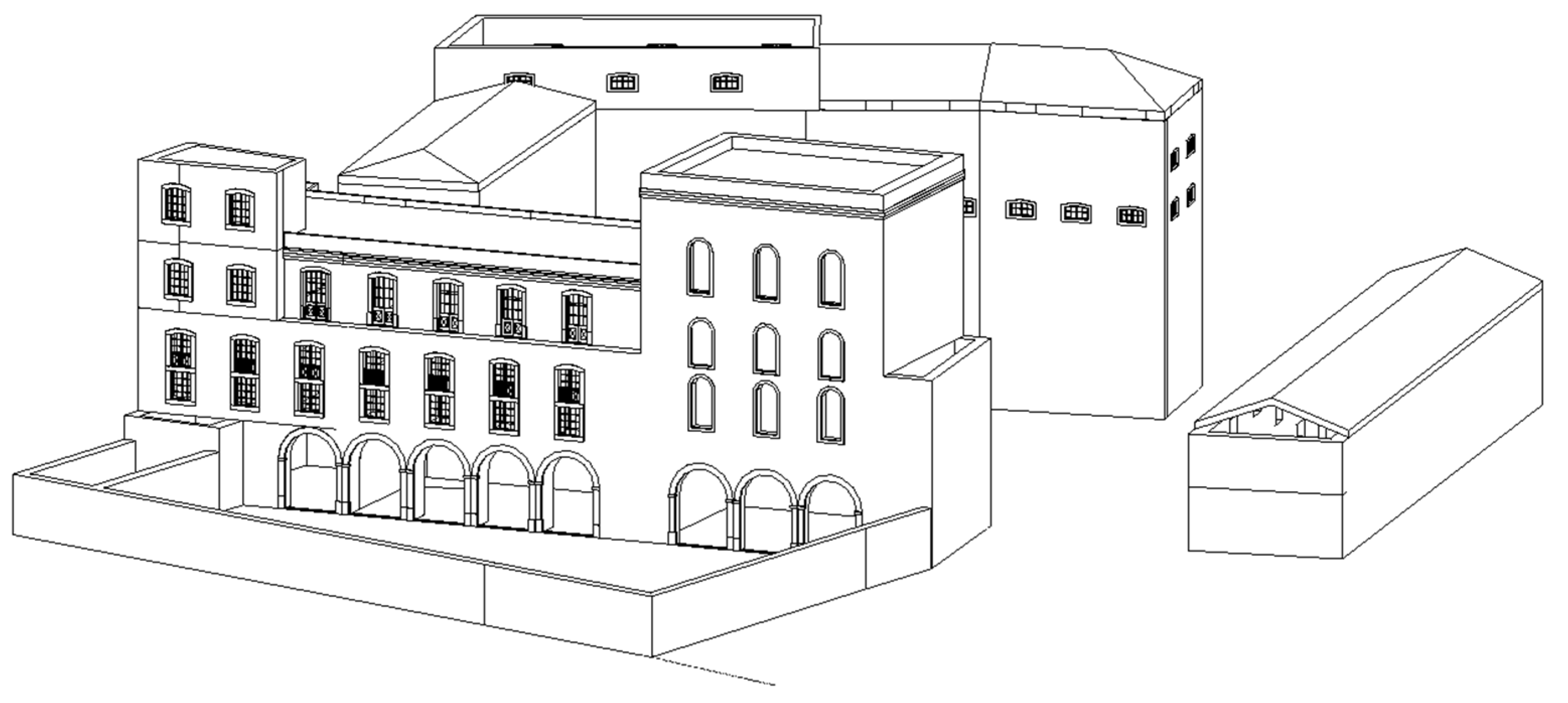
  • The process begins with the historic phase of the Castle of Faro. For the creation of the fortress wall, the create mass functionality was applied, following the layout represented in the ground plant of the consulted drawings. As some plants are related to the existing building and others are related to the mentioned Theodosius and Barracks antique drawings, an overlapping comparative drawings was then performed. These analyses allowed reconstructing the missing parts and the complete building of the tower. It was also found that the wall thickness of the military structure presented distinct thickness along its height. The wall element was defined as a mass, which was limited with two faces identifying the inside and the outside faces, using the functionality wall by face. To represent the raised pavement, the floor by face functionality was used. The first modelling stage is composed of walls and floors, following closely the real geometry of the Faro Castle;
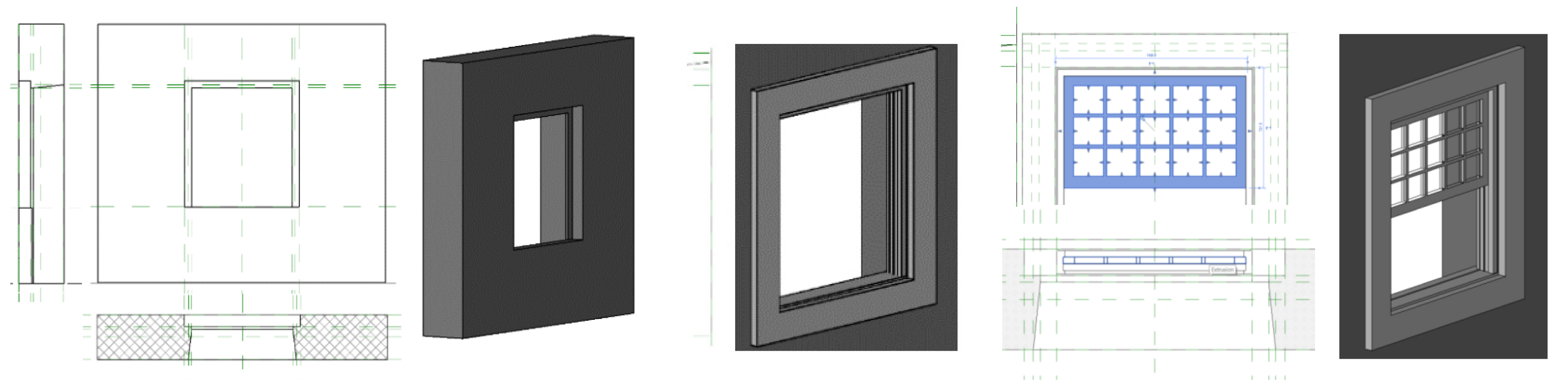
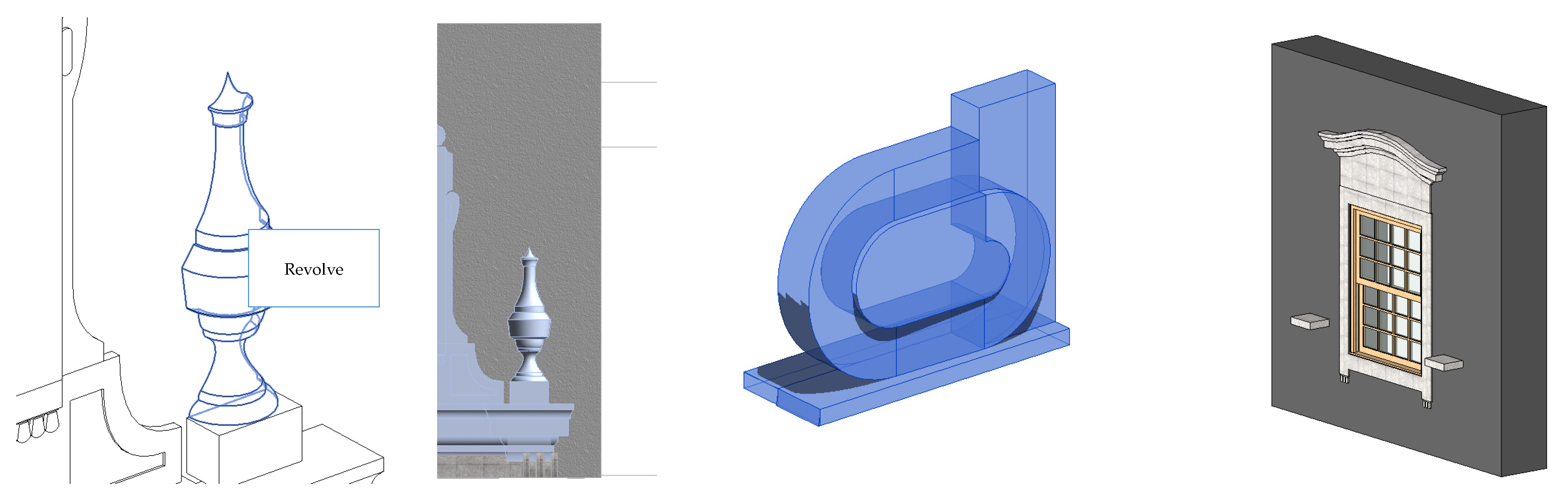
  • Going to the second phase, referring to the Military Quarter, a U-shaped building is identified. At this point, several families of windows (Figure 11) and doors (Figure 12) were generated, being the first specific elements created for the library of parametric objects of the present project. In the modelling process, the void forms option was used to cut the previous created wall as required to insert a window. The presence of two stairs, that provide access to the upper level, were also identified and modelled (Figure 12). For the creation of the stonework (Figure 13), the extrusion functionality was used to define the perimeter with the aid of straight and curved lines and a sweetened guide. Afterwards, the related material was associated to each new object: namely, wooden to the window structure, glass to the transparent panels and granite or calcareous to the stonework elements;
  • In the third phase, a three-storey building and a tower located outside the wall fortress were finally modelled. The structural walls of the tower presents distinct thicknesses. The modelling process was conceived floor by floor, following the generation of the structural walls from the lower level to the upper limit. This modelling phase is based on undated plans, but a comparative exercise confronted the available elevations, such as new structures or building elements. Some of the demolished parts were also identified and modelled in order to obtain an HBIM model with a correct historical memory.

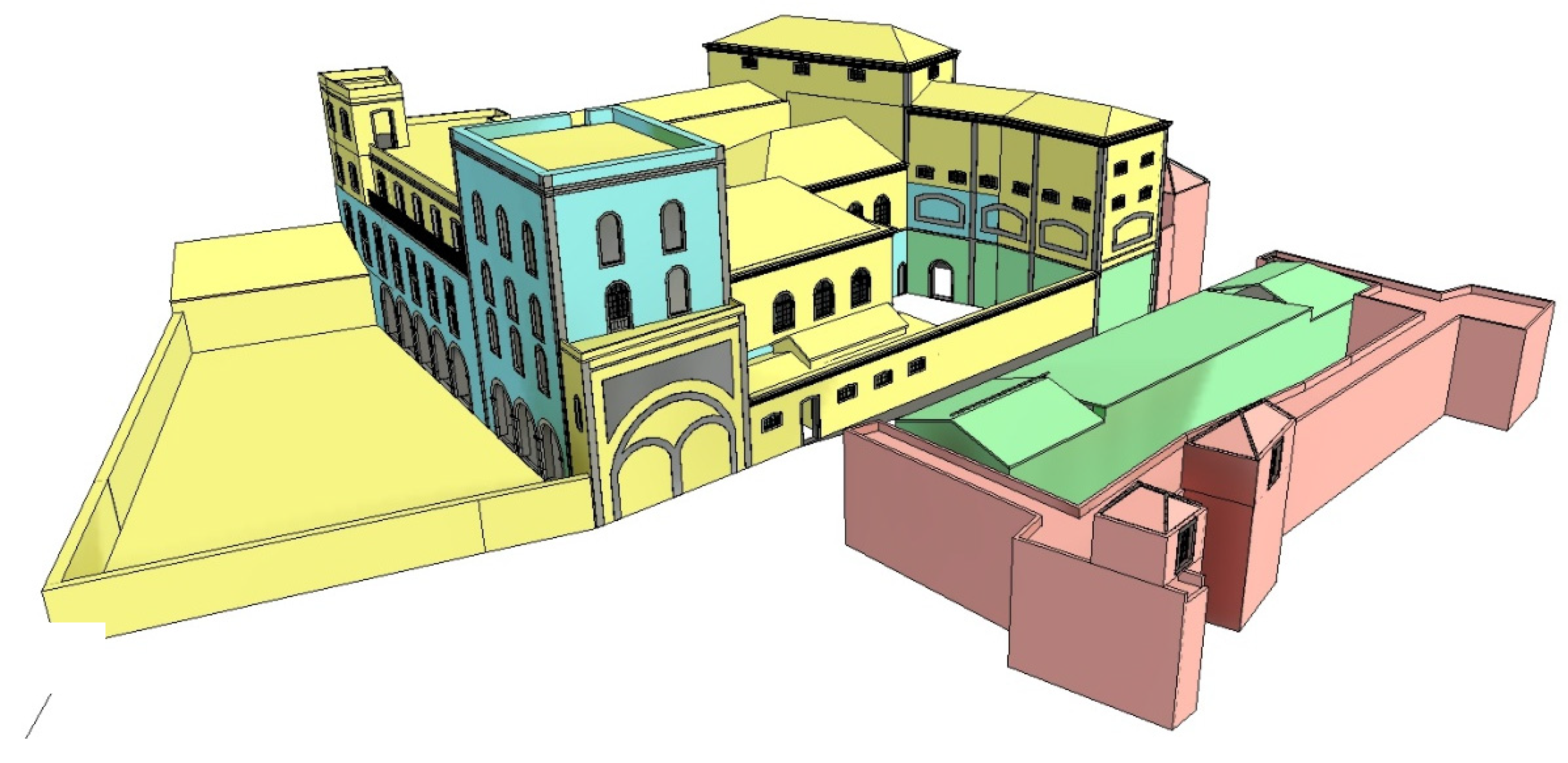
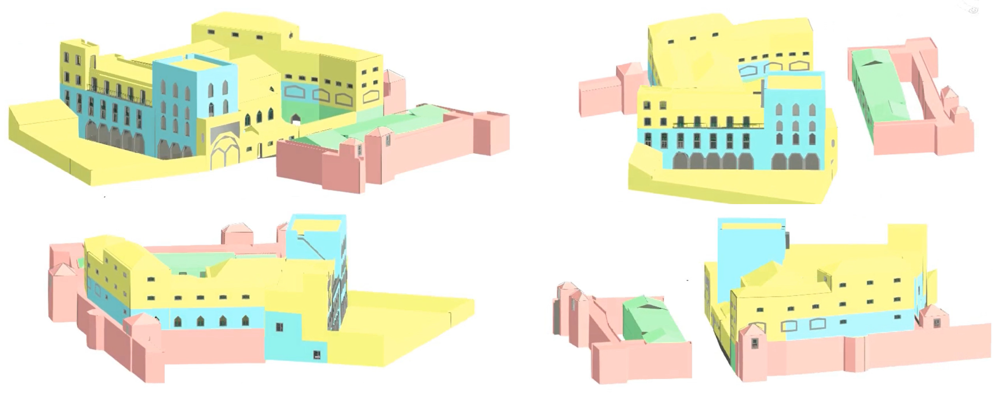
6.2. Stratigraphic Model

After a careful analysis of the plans and the existing building, a sufficient understanding of the historical evolution was conceived. A accurate HBIM model close to the real configuration was created. It corresponds to an overlapping process of the modelled components. This constitutes the definition of the required stratigraphic model. The stratigraphic HBIM model brings a 3D understanding of direct and indirect sources. The collected data are added to the HBIM model and each stratigraphic stage is associated to its proprieties and historical setting. For that, as illustrated in the present study, data collecting is mandatory as an initial step. In it, direct sources data collection, indirect data documentation, and the relation among the BIM object elements must be retrieved.
An HBIM model enhances historical stratigraphic interpretation by providing age constraints on construction steps identified through sequence stratigraphic interpretation [34]. In an HBIM context, the stratigraphic approach incorporates the 3D representation and documentation, distributed along historical and as-built steps, aiming to support experts involved in research and restoration phases [35]. A stratigraphic model introduces challenges in describing the 3D composition of construction components, namely, regarding thickness and the relationship between different wall layers [36]. A common data environment can be set up to share the 3D volume informative models that can be accessed, and all the information can be gathered [37].
As a base for the modelling process of the present case, a careful interpretation of the collected documentary material and images was carried out in order to create a rigorous representation of the building with accurate geometric and non-geometric information. The modelling process of an HBIM model considers the decomposition of architecture, based on structured criteria, and its reconstruction, through the main events of the historical evolution. This procedure linked the 3D data survey with the characteristics of the identified architectural tendencies in both historical and functional contexts of the building. Concerning the present case study, Figure 14 includes a perspective of the global HBIM model. Figure 15 presents two floor plant layouts that were obtained, in an automatic way, as a plan section applied over the complete model.
Based on the collected data, it was possible to divide the configuration of the structure into stratigraphic components. Four main historical phases were identified, and the correspondent model component was handled over the complete model. A colour scheme was applied as filters over the distinct historic components of the model, representing the different phases of the construction:
  • Red—Alcazaba of the castle and walls (VIII–XVII century);
  • Green—Military Artillery Quartering of the Kingdom of the Algarve (XVIII–XIX century);
  • Blue—Workspaces, canneries and other industries (1822–1935);
  • Yellow—Beer distillery Portugalia and the Infantry Regiment Quarter of Faro (1935–1999).
The four components were overlapped together in the centralised model. Using the Revit’s ‘Phases’ tool, the components were associated to the respective construction phase. This modelling option was adopted for the stratigraphic representation (Figure 16).
The created HBIM model allows a continuous comparison between the current building state and the stratigraphic as-built model. The relevant collected data were also associated to the project, inserted in specific directories made available to professionals that in a later phase can easily consult. The model can be visualised from distinct points of view (Figure 17).
Good data collection was completed around the castle complex, but depending on the type of posterior study that can be required, the HBIM model must be complemented with other information, namely the identification of the deterioration or anomalies verified over structural components or just walls or floor finishings. In a refurbishing situation, naturally, other local visual analyses and inspections (destructive and no destructive) must be undertaken.

7. Discussion and Conclusions

The main objective of the research was to define and persecute a suitable plan to perform an efficient data collection stage in order to generate a virtual stratigraphic HBIM model established with correctness and completeness, serving as useful work base to the development of eventual posterior preservation actions.
The generation of the model was supported by all the retrieved information. The basic data that were collected include paper drawings and digital documents, identification of the applied material and knowledge about traditional construction processes, sequences of as-built construction steps and historic context information. The capture of the rigorous geometric representation of the building was made using a large photographic survey by the inside and outside of the spaces in analyses.
The stratigraphic modelling process is a 3D representation type that can be used for exploring the historical evolution of a heritage building, which can be added with data easily retrieved within an HBIM model generated with rigor. A stratigraphic model, well-conceived, offers many advantages to heritage professionals and researchers, as it provides a useful platform for the analyses of the complexity of the sequence stratigraphy and as-built historical development. The main requirement to define a stratigraphic HBIM representation is a careful survey of the historical evolution context that affects directly the construction, demolishing and adaptation of the initial building to distinct types of occupations. A comprehensive database composed of historical reports, distinct notes, old technical drawings, and published material allows the identification of building components and the respective construction adaptation through ages. The stratigraphic HBIM created meets these requirements in order to play a key role in the representation of a cultural built heritage.
The reference of how to realise all processes from the data collection to the modelling procedure of a stratigraphic model brings an important contribution to the HBIM issue, carrying out the relevance of defining and planning a correct collecting data step. The described study reflects the perspective of how to obtain data from archives or capture by scanning equipment if necessary to perform the model with as much rigour as possible. The potential of HBIM as a centralised data platform supports the collecting, archive, integration and management of the essential information along a heritage building analyses. The text aims to contribute positively to the dissemination of the HBIM topic, in particular considering the data collecting phase. Therefore, HBIM can be seen as the new procedure to manage cultural heritage data and support heritage buildings studies, namely, conservation, restoration, retrofitting or maintenance.

Author Contributions

Conceptualisation, A.Z.S. and A.M.G.; methodology, A.Z.S. and A.M.G.; software, J.T.; validation, A.Z.S.; formal analysis, A.M.G.; investigation, J.T.; resources, J.T.; data curation, A.Z.S. and A.M.G.; writing—original draft preparation, A.Z.S.; writing—review and editing, A.Z.S.; visualization, A.M.G.; supervision, A.M.G.; funding acquisition, A.Z.S. and A.M.G. All authors have read and agreed to the published version of the manuscript.

Funding

The authors are grateful for the Foundation for Science and Technology’s support through funding UIDB/04625/2020 from the research unit CERIS, Civil Engineering Research and Innovation for Sustainability, University of Lisbon, Lisbon, Portugal.

Data Availability Statement

The principal information presented in the text was retrieved from a master work that is still in progress: João Tomé, Heritage Building Information Modelling (HBIM): Documentary collection and chronological information organisation, University of Lisbon, Lisbon, Portugal (in progress).

Conflicts of Interest

The authors declare no conflict of interest.

References

  1. Nagy, G.; Ashraf, F. HBIM platform and smart sensing as a tool for monitoring and visualizing energy performance of heritage buildings. Built Environ. 2021, 8, 100056. [Google Scholar] [CrossRef]
  2. Megahed, N.A. Towards a Theoretical Framework for HBIM Approach in Historic Preservation and Management. Int. J. Archit. 2015, 9, 130–147. [Google Scholar] [CrossRef]
  3. Lopez, F.J.; Lerones, P.M.; Llamas, J.; Bermejo, J.G.-G.; Zalama, E. A review of heritage building information modeling (H-BIM). Multimodal Technol. 2018, 2, 21. [Google Scholar] [CrossRef]
  4. Khalil, A.; Stravoravdis, S. Challenges of Digital Building Data Usage with a Focus on the Digital Documentation of Heritage Buildings: Results from an Online Survey. Heritage 2022, 5, 3220–3259. [Google Scholar] [CrossRef]
  5. Donato, V.; Biagini, C.; Bertini, G.; Marsugli, F. Challenges and opportunities for the implementation of HBIM with regards to historical infrastructures: A case study of the Ponte Giorgini in castiglione della pescaia. Int. Arch. Photogramm. Remote Sens. Spat. Inf. Sci. 2017, XLII-5/W1, 253–260. [Google Scholar] [CrossRef]
  6. Carnevali, L.; Lanfranchi, F.; Russo, M. Built Information Modeling for the 3D Reconstruction of Modern Railway Stations. Heritage 2019, 2, 2298–2310. [Google Scholar] [CrossRef]
  7. Attenni, M. Informative Models for Architectural Heritage. Heritage 2019, 2, 2067–2089. [Google Scholar] [CrossRef]
  8. Khalil, A.; Stravoravdis, S.; Backes, D. Categorisation of building data in the digital documentation of heritage buildings. Appl. Geomat. 2020, 13, 29–54. [Google Scholar] [CrossRef]
  9. Brusaporci, S.; Maiezza, P.; Tata, A. A framework for architectural heritage HBIM semantization and development. Int. Arch. Photogramm. Remote Sens. Spat. Inf. Sci. 2018, XLII-2, 179–184. [Google Scholar] [CrossRef]
  10. Murphy, M.; McGovern, E.; Pavia, S. Historic Building Information Modelling: Adding intelligence to laser and image based surveys of European classical architecture. ISPRS J. Photogramm. Remote Sens. 2013, 76, 89–102. [Google Scholar] [CrossRef]
  11. Kamaruzaman, N.; Solihin, U. Historic Building Information Modelling (Hbim): A Review. In Proceedings of the 4th International Conference on Rebuilding Place, Penang, Malaysia, 6–7 November 2019; pp. 587–594. [Google Scholar] [CrossRef]
  12. Rocha, G.; Mateus, L.; Fernández, J.; Ferreira, V. A Scan-to-BIM Methodology Applied to Heritage Buildings. Heritage 2020, 3, 47–67. [Google Scholar] [CrossRef]
  13. Baik, A. From point cloud to Jeddah Heritage BIM Nasif Historical House—Case study. Digit. Appl. Archaeol. Cult. Heritage 2017, 4, 1–18. [Google Scholar] [CrossRef]
  14. Liu, J.; Foreman, G.; Sattineni, A.; Li, B. Integrating Stakeholders’ Priorities into Level of Development Supplemental Guidelines for HBIM Implementation. Buildings 2023, 13, 530. [Google Scholar] [CrossRef]
  15. Brumana, R.; Condoleo, P.; Grimoldi, A.; Banfi, F.; Angelo Giuseppe, A.; Previtali, M. HR LOD based HBIM to detect influences on geometry and shape by stereotomic construction techniques of brick vaults. Appl. Geomat. 2018, 10, 529–543. [Google Scholar] [CrossRef]
  16. Dore, C.; Murphy, M. Integration of Historic Building Information Modeling and 3D GIS for recording and managing cultural heritage sites. In Proceedings of the 18th International Conference on Virtual Systems and Multimedia, Virtual Systems in the Information Society, Milan, Italy, 2–5 September 2012; pp. 369–376. [Google Scholar] [CrossRef]
  17. Bruno, N.; Roncella, R. HBIM for Conservation: A New Proposal for Information Modeling. Remote Sens. 2019, 11, 1751. [Google Scholar] [CrossRef]
  18. Oliveira, S.G.; Biancardo, S.A.; Tibaut, A. Optimizing H-BIM Workflow for Interventions on Historical Building Elements. Sustainability 2022, 14, 9703. [Google Scholar] [CrossRef]
  19. García, E.S.; García-Valldecabres, J.; Blasco, M.J.V. The use of HBIM models as a tool for dissemination and public use management of historical architecture: A review. Int. J. Sustain. Dev. Plan. 2018, 13, 96–107. [Google Scholar] [CrossRef]
  20. Bruno, N.; Roncella, R. A restoration oriented HBIM system for cultural heritage documentation: The case study of Parma cathedral. Int. Arch. Photogramm. Remote Sens. Spat. Inf. Sci. 2018, XLII-2, 171–178. [Google Scholar] [CrossRef]
  21. Park, S.; Yoon, S.; Ju, S.; Heo, J. BIM-based scan planning for scanning with a quadruped walking robot. Autom. Constr. 2023, 152, 104911. [Google Scholar] [CrossRef]
  22. Cestari, C.B.; Marzi, T. Conservation of historic timber roof structures of Italian architectural heritage: Diagnosis, assessment, and intervention. Int. J. Sustain. Dev. Plan. 2018, 12, 632–665. [Google Scholar] [CrossRef]
  23. Hull, J.; Ewart, I.J. Conservation data parameters for BIM-enabled heritage asset management. Autom. Constr. 2020, 119, 103333. [Google Scholar] [CrossRef]
  24. Antonopoulou, S.; Bryan, P. BIM for Heritage: Developing a Historic Building Information Model. 2016. Available online: https://historicengland.org.uk/images-books/publications/bim-for-heritage/heag-154-bim-for-heritage/ (accessed on 4 September 2023).
  25. Boardman, C.; Bryan, P. 3D Laser Scanning for Heritage. Historic England: Swindon, UK, 2018. Available online: https://historicengland.org.uk/images-books/publications/3d-laser-scanning-heritage/heag155-3d-laser-scanning/ (accessed on 4 September 2023).
  26. Sampaio, A.Z.; Pinto, A.M.; Gomes, A.M.; Sanchez-Lite, A. Generation of an HBIM Library regarding a Palace of the 19th Century in Lisbon. Appl. Sci. 2021, 11, 7020. [Google Scholar] [CrossRef]
  27. Sampaio, A.Z.; Sanchez-Lite, A.; Zuluta, P.; Gonzalez, C. BIM application in the conservation of buildings of heritage value. In Proceedings of the 4th Meeting of Conservation and Rehabilitation of Buildings, Lisbon, Portugal, 3–6 November 2020. [Google Scholar]
  28. Sampaio, A.Z.; Pinto, A.M.; Gomes, A.M. Historic Building Information Modelling (HBIM): Parametric modeling and documentation file. In Proceedings of the 4th Meeting of Conservation and Rehabilitation of Buildings, Lisbon, Portugal, 3–6 November 2020. [Google Scholar]
  29. Palestini, C.; Basso, A.; Graziani, L. Integrated photogrammetric survey and BIM modelling for the protection of school heritage, applications on a case study. International Archives of the Photogrammetry. Remote Sens. Spat. Inf. Sci. 2018, XLII-2, 821–828. [Google Scholar] [CrossRef]
  30. Quattrini, R.; Battini, C.; Mammoli, R. HBIM to VR. Semantic awareness and data enrichment interoperability for parametric libraries of historical architecture. International Archives of the Photogrammetry, Remote Sens. Remote Sens. Spat. Inf. Sci. 2018, 42, 937–943. [Google Scholar] [CrossRef]
  31. Tomé, J. Heritage Building Information Modelling (HBIM): Organization of documentary collection and chronological information. Master’s Thesis, University of Lisbon, Lisbon, Portugal. in progress.
  32. Mateus, L.; Fernández, J.; Ferreira, V.; Oliveira, C.; Aguiar, J.; Gago, A.S.; Pacheco, P.; Pernão, J. Graphical data flow based in TLS and photogrammetry for consolidation studies of historical sites. The case study of Juromenha fortress in Portugal. Int. Arch. Photogramm. Remote Sens. Spat. Inf. Sci. 2019, 42, 767–773. [Google Scholar] [CrossRef]
  33. KIRI Engine. Available online: https://www.kiriengine.com/ (accessed on 4 September 2023).
  34. Shafie, K.; Madon, M. A review of stratigraphic simulation techniques and their applications in sequence stratigraphy and basin analysis. Bull. Geol. Soc. Malays. 2008, 54, 81–89. [Google Scholar] [CrossRef]
  35. Banfi, F.; Brumana, R.; Landi, A.G.; Previtali, M.; Roncoroni, F.; Stanga, C. Building archaeology informative modelling turned into 3D volume stratigraphy and extended reality time-lapse communication. Virtual Archaeol. Rev. 2022, 13, 1–21. [Google Scholar] [CrossRef]
  36. Stanga, C. Stratigraphic units inside heritage building information model: A novel approach for the representation of building archaeology. Int. Arch. Photogramm. Remote Sens. Spat. Inf. Sci. 2023, XLVIII-M-2, 1519–1526. [Google Scholar] [CrossRef]
  37. Muñoz-Muñoz, A.; Fernández-Sánchez, D.; Vijande-Vila, E.; Becerra-Martín, S.; Cantillo-Duarte, J.J.; Domínguez-Bella, S.; Martínez Enamorado, V.; Rengel Castro, F.; Cantalejo Duarte, P.; Espejo-Herrerías, M.d.M.; et al. Application of photogrammetry and laser scanner on the Bronze Age structures of the Castillejos de Luna cist tomb necropolis (Pizarra, Spain). Virtual Archaeol. Rev. 2023, 14, 26–44. [Google Scholar] [CrossRef]
Figure 1. Methodology applied in the study.
Heritage 06 00338 g001
Figure 2. Identification of material: regular stones and cement plaster.
Heritage 06 00338 g002
Figure 3. Images available in IPA 00001316 web page.
Heritage 06 00338 g003
Figure 4. Codex Cadaval plan and square of Faro plan.
Heritage 06 00338 g004
Figure 5. Drawing of the military quarter and the city plan (1763).
Heritage 06 00338 g005
Figure 6. Photogrammetric capture over a metallic column.
Heritage 06 00338 g006
Figure 10. Pencil sketches taken in the place concerning a window.
Heritage 06 00338 g010
Figure 11. Modelling process of a window of the eighteenth-century.
Heritage 06 00338 g011
Figure 12. New HBIM parametric objects of doors and stairs.
Heritage 06 00338 g012
Figure 13. New HBIM parametric objects of stonework elements.
Heritage 06 00338 g013
Figure 14. HBIM model of the global building.
Heritage 06 00338 g014
Figure 15. Two floor plant layouts obtained from the HBIM model.
Heritage 06 00338 g015
Figure 16. Perspective of the stratigraphic HBIM model.
Heritage 06 00338 g016
Figure 17. The model visualised from distinct points of view.
Heritage 06 00338 g017
Disclaimer/Publisher’s Note: The statements, opinions and data contained in all publications are solely those of the individual author(s) and contributor(s) and not of MDPI and/or the editor(s). MDPI and/or the editor(s) disclaim responsibility for any injury to people or property resulting from any ideas, methods, instructions or products referred to in the content.

