
Digging through Databases—A Case Study of Iron Age Sites in Finland by Generating and Analysing Keywords


1
Faculty of Agriculture and Forestry, University of Helsinki, 00014 Helsinki, Finland
2
Department of Forest Science, Faculty of Agriculture and Forestry, University of Helsinki, 00014 Helsinki, Finland
3
Department of Remote Sensing and Photogrammetry, Finnish Geospatial Research Institute (FGI), National Land Survey of Finland (NLS), Vuorimiehentie 5, 02150 Espoo, Finland
*
Author to whom correspondence should be addressed.
Heritage 2023, 6(8), 5919-5934; https://doi.org/10.3390/heritage6080311
Submission received: 8 June 2023
/
Revised: 15 August 2023
/
Accepted: 17 August 2023
/
Published: 18 August 2023
Abstract
:The primary purpose of this study is to open the discussion of FAIR principles in Finnish archaeology. This topic has not yet been actively discussed in Finnish archaeology. In this study, we were testing whether adding keywords could increase the reusability of the Register of Ancient Sites, as the reusability level of the current register is low. The case study focuses on creating an overview of the Iron Age sites in the Itä-Häme area. Keywords were added for all of the 585 archaeological sites in the study area, based on field reports and find catalogues. After giving keywords to all of the sites, it was possible to make queries from the register and form a new, more detailed overview of the Iron Age sites in the Itä-Häme area. Our study revealed mistakes and ambiguities in the register, but adding keywords increased its reusability. However, it cannot solve the main issue: basic research has not been carried out extensively enough in Finland. Based on the overview, it can be seen that Itä-Häme was an active and important area in the Iron Age, and an especially meaningful possible new site type was identified; however, more research in this area is needed.
Keywords:
archaeology; FAIR principles; Iron Age; Itä-Häme; GIS; cultural heritage; database; digital archaeology1. Introduction
FAIR principles in archaeology are an important topic in this increasingly digital era. As Nicolson et al. summarized, making data FAIR should become a cornerstone of archaeological research [1]. The FAIR principles have also been discussed in Nordic archaeology in recent years [2,3]. FAIR principles mean that the data should be made Findable, Accessible, Interoperable, and Reusable [4]. Currently, there are many projects related to FAIR principles in archaeology, including ADRIANEplus [5], Europeana Archaeology [6], and TETRARCHs [7]. Nonetheless, in Finnish archaeology, discussion about FAIR principles has been quite minimal so far. However, FAIR principles have come very relevant at the moment, because associated legislation is currently being reformed in Finland. The new Antiquities Act in Finland will affect the treatment of archaeological data and the cultural heritage branch in general. The urgent demand to develop the register and other services is also a known issue at the Finnish Heritage Agency, and a preliminary investigation of the register’s development needs was published in February 2023 [8]. The Finnish Heritage Agency has also published quality guidelines for archaeological fieldwork, with the last update performed in 2020 [9]. The reformed Antiquities Act will also create a need to update those quality guidelines. Finnish archaeology will soon be facing a turning point when the law is reformed, so discussions are needed now, in this defining moment of our cultural heritage studies. This current situation, and the significant problems with the register’s usability encountered in previous research, served as an inspiration for this case study [10].
In this paper, we are studying whether the addition of keywords that include background information about archaeological sites can increase data findability and reusability. The register of ancient sites in Finland has a clear structure: every site should have an ID number, name, information about the municipality where the site is located, type, subtype, date, and mention whether the site is underwater or not. This database structure is simple, but it also limits the findability and reusability of the register. Giving all of the sites new keywords could be one solution to increasing the usability of the register. However, it is important to evaluate the advantages and disadvantages, or challenges, of using that method. By choosing this case study approach, we also aim to create a regional overview of the Iron Age sites in the Itä-Häme (East Tavastia) region. Iron Age research in Finland has long been focused on Southwest Finland, and the general view of the sites and site types in the chosen research area is still very unclear. With this study, we aim to enhance the understanding of FAIR principles within Finnish archaeology and, in particular, emphasize the significant role of archaeological research and analyses overall. This article is part of a PhD thesis, and it focuses on more general-level issues, as the other parts of the studies are more detail-focused. General information about the register and archaeological site locations in the Itä-Häme area is needed to support both previous and forthcoming studies.
The Register of Ancient Sites (Muinaisjäännösrekisteri) is an archaeological database maintained by the Finnish Heritage Agency [11]. The register is part of the cultural environment service page (kulttuuriympäristön palveluikkuna), which also includes other databases, such as the register of archaeological projects, reports about cultural heritage, and find catalogues [12]. There are links between the register of ancient sites and those other databases under the cultural environment service page. However, in some cases, those links are missing, and more searching is needed to find those reports or find catalogues. The reports about archaeological studies that were performed after the year 2017 can be found in a separate database called Museoviraston asiat [13]. In that new report database, the user can search documents by words (for example, site name) or by municipality, and the results (documents) can be limited to a certain period. Overall, the current archaeological database systems in Finland are quite incoherent, which reduces the level of data findability and reusability. The planning of the register started already in the 1980s, and the prototype was tested in the early 90s, with the register of ancient sites eventually being created in 1996. Many solutions that were included in the original version can be still seen in the register today. The distribution of site types and subtypes was already discussed in an article published in 2003 [14]. In the beginning, the register was only used by authorities in the Finnish Heritage Agency. The register was published openly on the Internet in 2009, and in 2010, some agreements were also made between the provincial museum authorities and the Finnish Heritage Agency to update the register [8]. Today, the register of ancient sites is maintained by the Finnish Heritage Agency, but the content, for example information about the sites, can be updated by provincial museum authorities. Some articles about the register and its updates have been written, mainly from the authorities’ perspective, but studies from the researcher’s viewpoint still seem to be missing, and this paper is trying to fill that gap [15]. From a research point of view, the current registers have many problems, especially concerning findability. The site descriptions do not always provide the needed background information, such as the culture, find types or time period the site is connected to. When detailed information is needed, it often requires countless hours of extra work from the researcher to find something useful from the register, as searching by keywords is not possible. The PDF-formatted reports and find catalogues are not always searchable either, as they might be old handwritten and scanned reports. Sometimes, visiting the collections, and manually going through the finds is the only option to find needed information, as was the case in the previous study.
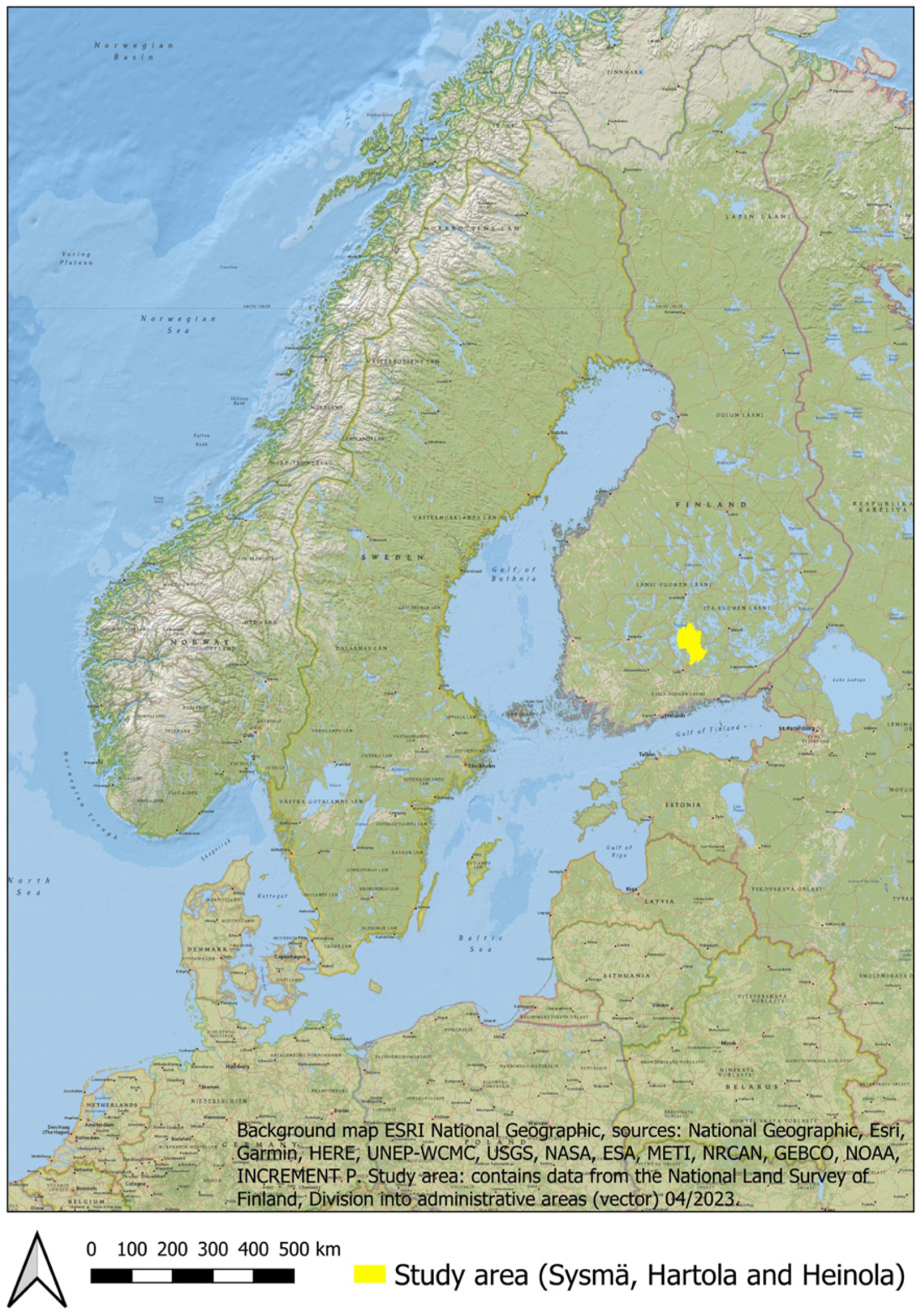
This paper focuses on the usability of the register from the research point of view, and a suitable case study area was found in the Itä-Häme (East Tavastia) region. The study area consists of three municipalities: Sysmä, Hartola, and Heinola (Figure 1). The study area was chosen for two reasons. The area is rich in Iron Age sites and known for remarkable Iron Age finds, but from the archaeological research perspective, it is a forgotten region and a poorly known area. Previous research in the area has been minimal, especially when compared to the number of remarkable sites and considering the presence of some rich treasure troves. By choosing an area that has a large number of sites and where research has been minimal, it is possible to obtain the maximum impact from both perspectives: testing the keywords, and producing new information about this quite unknown territory. All three of the selected municipalities belong to the East Tavastia (Itä-Häme) region. Other municipalities in the Itä-Häme region (Joutsa, Luhanka, Pertunmaa) today belong to a different province, and they also belong to a different regional museum response area. So, in this study, we decided to limit the study area to those three municipalities that are under the authority of the same responsible museum: the Päijät-Häme Museum [16]. In this paper, by the area name Itä-Häme we refer to those three chosen municipalities: Sysmä, Hartola, and Heinola. The earliest report related to the archaeology of the study area is from the year 1897 [17]. The report describes some finds and sites from the Heinola and Sysmä municipalities. The first book about the local history of the area was published in 1925, and includes a chapter about the prehistory of the Sysmä and Hartola municipalities [18]. In 1920, Alfred Hackman excavated Iron Age burial cairns in Sysmä [19]. Based on the rich finds, the burial site has been interpreted as belonging to the Migration Period (550–600 AD). In the 1950s and 1960s, some surveys were performed in Sysmä, and in 1966, one Viking Period (800/825–1025/1100 AD) burial site [20] was excavated in Salonsaari, Sysmä. The best-known Iron Age site in Sysmä is called Ihananiemi, which has been partly excavated a few times and been the subject of many surveys since the 1950s [21]. Most of the surveys in the Sysmä municipality were performed in the 1990s and at the beginning of the 2000s. More recent surveys in the area were related to the Finnish Heritage Agency’s VARK project [22] and, in those surveys, many site coordinates were fixed more accurately than in the previous ones. The first small survey related to the Iron Age in Hartola was carried out in 1928 [23], followed by more small surveys in the area in the 1950s, 1960s, and 1980s. Wider surveys in Hartola were conducted at the beginning of 2003 and 2004. Some small excavations in Hartola were carried out in 1988, 2003, and 2004. Larger surveys and excavations in Hartola were conducted in 2020 and 2021, related to the rebuilding and maintenance of the Finnish National Road 4. In Heinola, most of the surveys were carried out at the beginning of the 2000s. There have been no excavations related to the Iron Age sites in Heinola. Overall, the research in this study area has been very minimal. One scientific article about Iron Age settlement sites in Sysmä was written in 2011 [24], but otherwise, the topic has not been properly discussed before in research papers. A general overview is clearly needed before more detailed studies can be performed in the Itä-Häme area.
2. Materials and Methods
The register of ancient sites (for research use) was downloaded in one zip file from the Finnish Heritage Agency’s web page on the 1st of September 2022. Any updates that were performed after that to the register for the study area are not considered in this paper. The zip file contains all of the sites that are in the register in vector format (points and polygons). In this research, the point format vector file named “Muinaisjaannospisteet_t_point” was chosen as the main material. Some sites do not have area definitions in polygon form, so that file format was not suitable for this type of case study research. The current downloadable vector file includes the following relevant columns: ID, name, municipality, dating, type, subtype, status (protected archaeological site/“other cultural heritage site”, etc.), coordinates, underwater (yes/no). The information in these columns consists of very simple predefined categories. For example, in the dating column, there is usually only a rough dating estimation like “Stone Age” or “Iron Age”. The type column also includes very general terms like “settlement sites” or “burial sites”. More detailed classifications like “cup-marked stones” or “burial cairns” can be found under the subtype column. This means that only very general terms can be used for searching and making queries from the current register. Since the vector file does not include written site descriptions, those texts cannot be used for queries either. Searching from the register web page is not possible either, because only these simple and predefined categories can be used for searching from the database. The only difference is the site names and ID numbers that can be typed and searched on the web version of the register. The shapefile was opened in QGIS, and all of the sites in the study area were extracted by using the municipality names in query and then exported as a new shapefile. The attribute table, including all sites in the three municipalities, was then exported in CSV format and the workflow then continued in Excel. In the table format, three new columns were created for more precise dating, keywords, and year of the last field research at the site. All possible information that was available via the Finnish Heritage Agency’s web page, including research reports, find catalogues, site descriptions, and information on the time of the research was used to gather information about the site and to form keywords based on that research knowledge. Most of the material is available in open access via the Finnish Heritage web page, but nine find catalogues were hidden in that system, and those could only be read in the Finnish Heritage Agency’s office in Helsinki.
Keywords (minimum one word per site) were given to every site in the Excel table. The keywords were collected from the site type and subtype section, dating (as accurate as possible), site descriptions, field study reports, find catalogues and, in a few cases, also from literature such as local history books [18]. Synonyms were also used; for example, cup-marked stones were given the keyword cup-marked stone (kuppikivi) and their synonym “uhrikivi”, a term which seems to be widely used in old research papers and reports. Some of the keywords were simplified for the finds; i.e., instead of “quartz flake” we used just the term “quartz” (kvartsi). The main reason for this is the challenges faced in interpreting various terms. In some reports, quartz objects are well described, but in many reports, there can be simply a guess at the object type, for example “possible quartz flakes” or just simply a mention of “quartz”. We could not identify the types more precisely based on the reports or find catalogues. If a pottery type was mentioned, then it was used as a keyword, but in many cases, there was just a mention of “pottery”. Some keywords that describe topography or site structures were used, such as pit, cairn, stone structure, road, etc. Keywords describing the local nature or landscape could also be useful, but, in most cases, there is just too little information about those aspects in the site descriptions or the field reports. Some sites have only one, or perhaps a few, sentences on the site description, and the quality of the information in the reports varies widely. Where the level of information was very minimal, we were able to assign just one or two keywords as applicable.
After giving all of the sites new keywords and adding information about the latest research year, the CSV table was then exported back to QGIS and saved as an SHP file (vector format). With the newly created vector file, it was possible to use the keywords for queries to identify and plot new information about the Iron Age sites in the research area. Because QGIS does not work well when using the Finnish letters ä or ö, all of those were replaced with “a” and “o” letters.
3. Results
The research area included 585 sites altogether. Besides archaeological sites protected by law (kiinteä muinaisjäännös), this number also includes possible sites, other cultural heritage sites, destroyed sites, find places, and the class “other sites”, which includes, for example, natural monuments. Find places (or stray finds) are artefacts that have often been found by accident and, if there is no evidence of an actual archaeological site, then such places are defined as a “find place” in the register. Assigning the keywords was easy when there was enough background information available, such as for those sites that have been excavated or studied in recent years. For example, the studies conducted in the Hartola municipality in recent years were excellently documented and described. However, for some sites, the process of finding and reading all of the material took quite some time and effort. Overall, it is difficult to estimate the time that would be needed to assign keywords for all of the sites in the register, because it may vary depending on the research level of each area. Adding the latest date of research in one column, based on the information given in the Finnish Heritage Agency’s web version of the register, turned out to be a poorly functioning solution. The dates or years when the research was conducted for each site are listed in the register, but in practice, the information is not always reliable. In some cases, archaeological survey reports may mention the site, as it was part of the survey area, but this does not mean that the site was even visited at that time. The situations for individual field studies vary and, especially during the larger area surveys, it was not always possible to visit all the sites. As a result, a user might get the impression from the register that a site was surveyed and visited lately, but a reliable research history can only be found by going through all of the research reports.
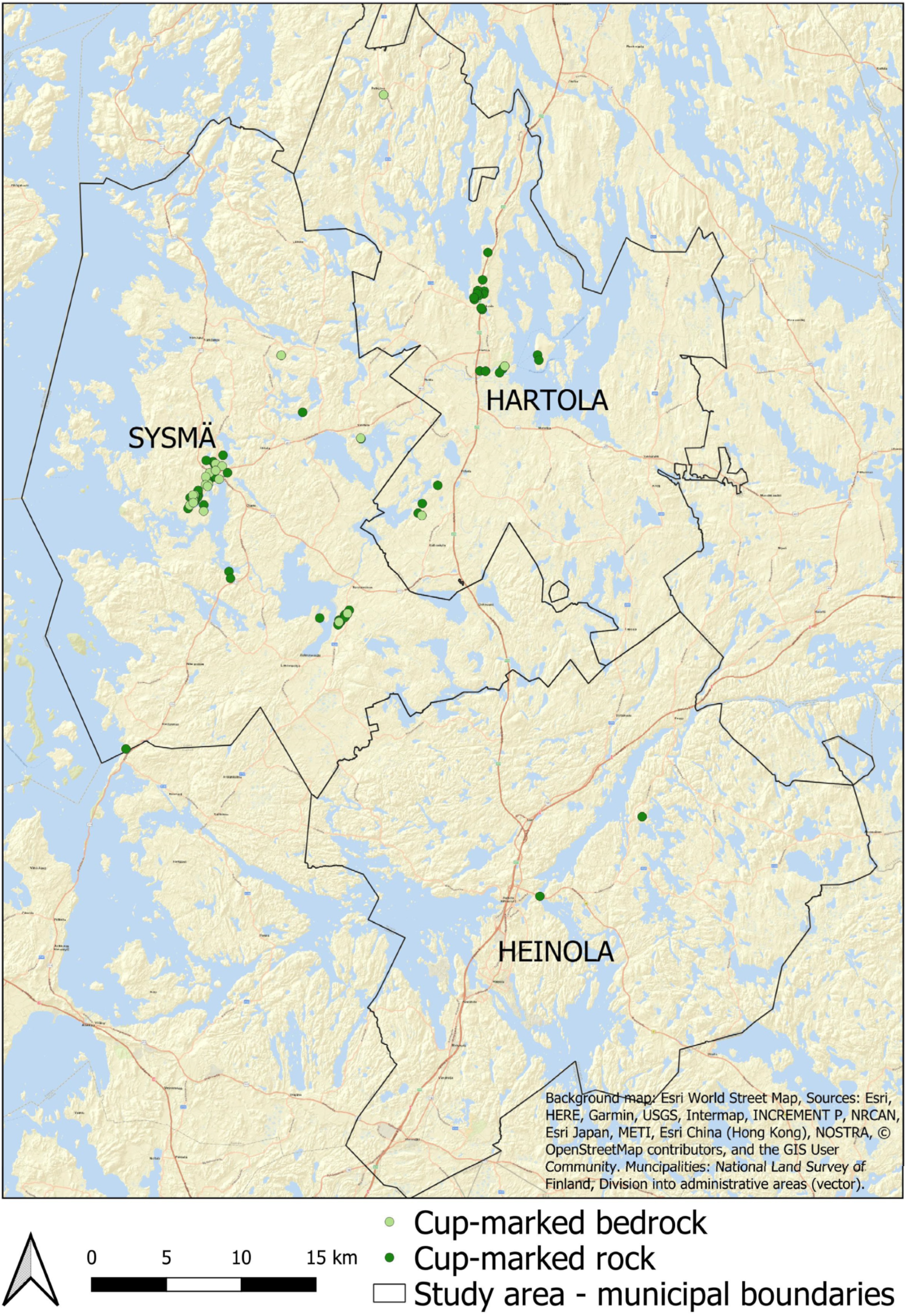
Reading all of the reports and descriptions associated with the sites revealed several instances of unclear and missing information. For example, Hartola’s site Kermamäki [25] is classified as a stone structure and a cairn, but reports indicate that it is probably an Iron Age cremation burial site; burnt bones and objects interpreted as Iron Age finds were found in the cairn. The link to the research report is missing in the register, and the link to the recent osteological report does not seem to work either. While the research report can be found in the reports section of the service portal, the osteological research report was completely missing, at least at the time of writing this article (April 2023). Similar deficiencies in the links were found in many site descriptions. There were also ambiguities in the dating of the sites. For example, the site called Kotisalo [26] in Hartola is defined as Iron Age and Medieval, but nothing in the site’s information refers to the Middle Ages. All of the finds and structures refer to the Iron Age, so it remains unclear why the site is also classified as Medieval. The dating also seems unclear regarding Hartola’s site Hiekkaniemi [27]. The site is defined in the register as a Stone Age settlement site, but the research report mentions that iron slag was found at the site and that the pottery looks mostly like that from the Iron Age [28]. In addition, many quartz objects, flakes, or fragments have been found at the site. There are mentions of quartz flakes and quartz objects from many Iron Age sites in the area, so those lithic finds are not necessarily always related to the Stone Age, and can thus distort the interpretation of the dating of many sites in the area. Rautaportti [29] in Heinola is an example of a site for which information is almost completely missing from the register. The site has been identified as a Stone Age find place, and it has a coordinate point, but the site description is missing, as well as any information about the research and the found object itself. However, it is probably the find location of the chisel mentioned in the description of the adjacent site. The descriptions of many sites in the register are also quite short. For example, the description of the Iso-Palpanen site [30] in Heinola consists of only three short sentences. There were especially many errors in the information about cup-marked stones and cup-marked bedrock. Many examples of cup-marked bedrock in the area were classified as cup-marked stones. However, there is a difference between the types. For cup-marked stones, cup-shaped impressions are made in stones or boulders, and these are not always still located in their original find place; the stones could have been moved later, and there are mentions of moving the stones in several of the cup-marked stones descriptions. Cup-marked bedrock is rarer; this has cup-shaped impressions in bedrock outcrops, and thus their location always corresponds to the original find location. Regarding the coordinates, the information for many sites is based on studies that were performed at a time before precise GPS devices and modern positioning methods. Recent studies on the sites have shown that many of the earlier coordinate data is incorrect. Therefore, the location information of all the sites in the study area should be viewed with caution, if they are not based on more precise GPS measurements taken in recent years.
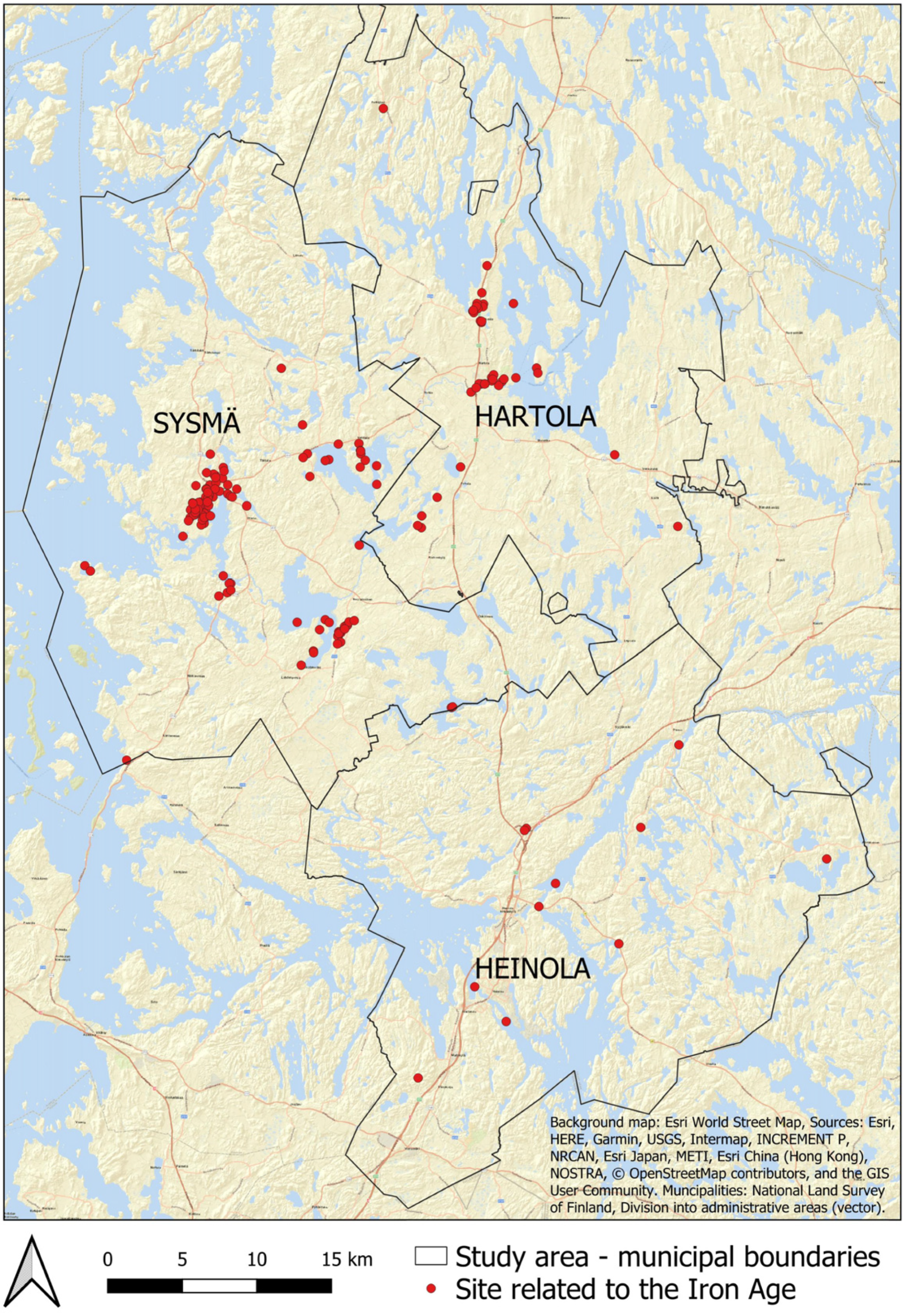
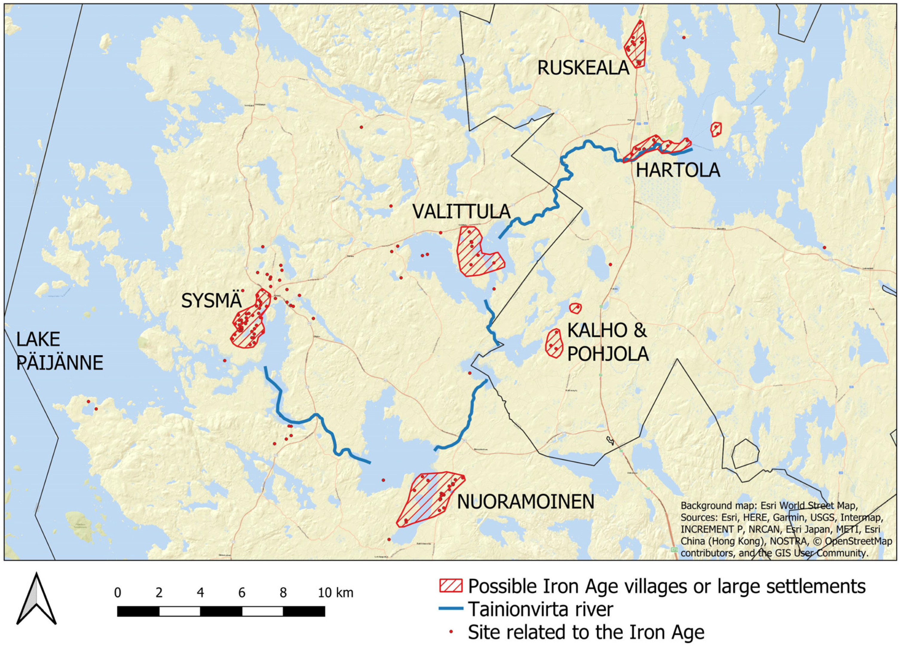
The addition of keywords made it easy to collect information about Iron Age sites in the study area. By using the new keywords, all of the sites that have a connection to the Iron Age were identified and mapped (Figure 2). In this study, 160 sites were classified as Iron Age sites in the research area. The largest number are found in Sysmä, which has 111 Iron Age sites. In Hartola there are 38 sites, and in Heinola, there are only 11 Iron Age sites. The sites form interesting clusters that could reflect village-type settlements, especially in the Sysmä and Hartola area (Figure 3). However, when interpreting the results, it must be taken into account that in some cases one point refers to one site and sometimes one point refers to one site plus many subsites. One point on a map may also refer to a site that actually incorporates a large area. Overall, the location of Iron Age sites in the area reflect the significance of the waterway known as Sysmän reitti (Sysmä route) and the agricultural landscape. Sysmä is located on the eastern shore of Lake Päijänne, and it is possible to travel from Päijänne to the Lake Puula/Savo area via the river called Tainionvirta. An article from the year 2010 calls this route “an Iron Age highway” [31]. The largest cluster of sites is located near the Sysmä village centre. The area includes cup-marked stones, Iron Age settlement sites, and cemetery sites. Many remarkable finds have been made in this area and, considering the density of Iron Age sites, it is very likely a large Viking Age settlement area. One place name from inside this cluster area is “The Great Village” (Suurkylä), and the first written mention of this village is from the year 1462 [32]. The villages of Nuoramoinen and Lahdenpohja in this area also seem to have had many large Iron Age sites, and these were interpreted as one possible village cluster. Nuoramoinen was one of the largest villages in Sysmä, and Iron Age sites in the area are large and rich. The villages of Kalho and Pohjola seem to form another possible cluster together. In the Kalho area, there is an especially large and complex site that includes many cairns, which are most likely burial cairns [33]. Today, the Kalho and Pohjola area is not so densely built up, which gives the area a high archaeological value as it is less disturbed. The Valittula village area could also form another cluster, but more field studies are needed to confirm the boundaries of the possible Iron Age village. The Hartola centre area may have formed one village or settlement area, but today, the area is quite built up, and the landscape has been disturbed by, for example, a golf course that makes interpretations more difficult. North of the Hartola centre lies Ruskeala, which could have formed a smaller village. These possible village areas could all be related to the Viking period, as most of the finds from those areas have been interpreted as belonging to that age.
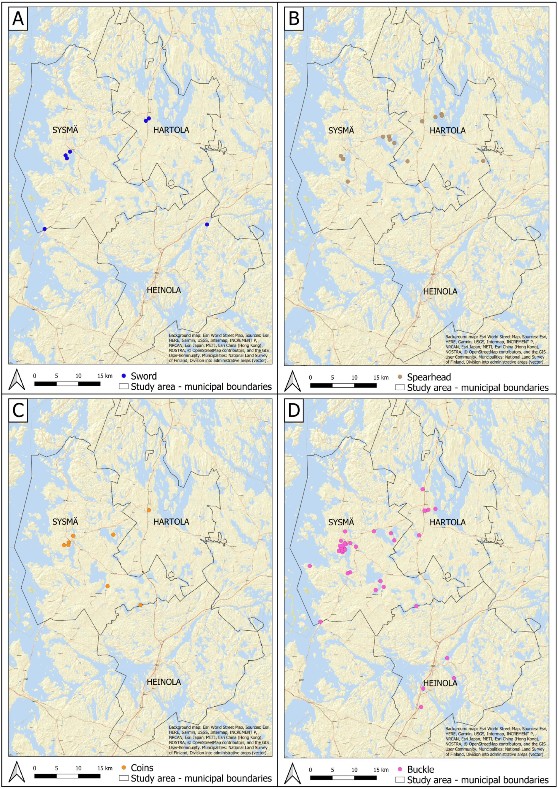
By using the new keywords, it is possible to extract individual artefact types from the data on the map (Figure 4). For example, the swords seem to be concentrated on the possible main village sites of Sysmä and Hartola. Two other separate sword finds have been interpreted as perhaps being related to individual burials from the Merovingian period. Spearheads have also been found in these possible village settlements, especially in the Valittula area. Coin finds are also concentrated in these possible villages and, in addition, one silver coin cache was found in a more remote site, which may also be related to some type of cemetery or burial. Many types of buckles have been found in the area, and their geographical distribution is also wider.
Two interesting site types are those associated with cup-marked stones and cup-marked bedrock (Figure 5). Those special site types seem to be strongly related to other Iron Age sites and findings. They are rarely located “alone” as a single Iron Age site, a factor that should also be considered when conducting a survey or other archaeological fieldwork in the area. There are a few of these types of sites that do not have any other Iron Age sites close by, but those same areas seem to be lacking in archaeological surveys and are also potential areas for new Iron Age discoveries. The extent of new construction is, of course, a problem, and it is possible that, especially in Heinola, many Iron Age sites have already been destroyed by urban expansion.
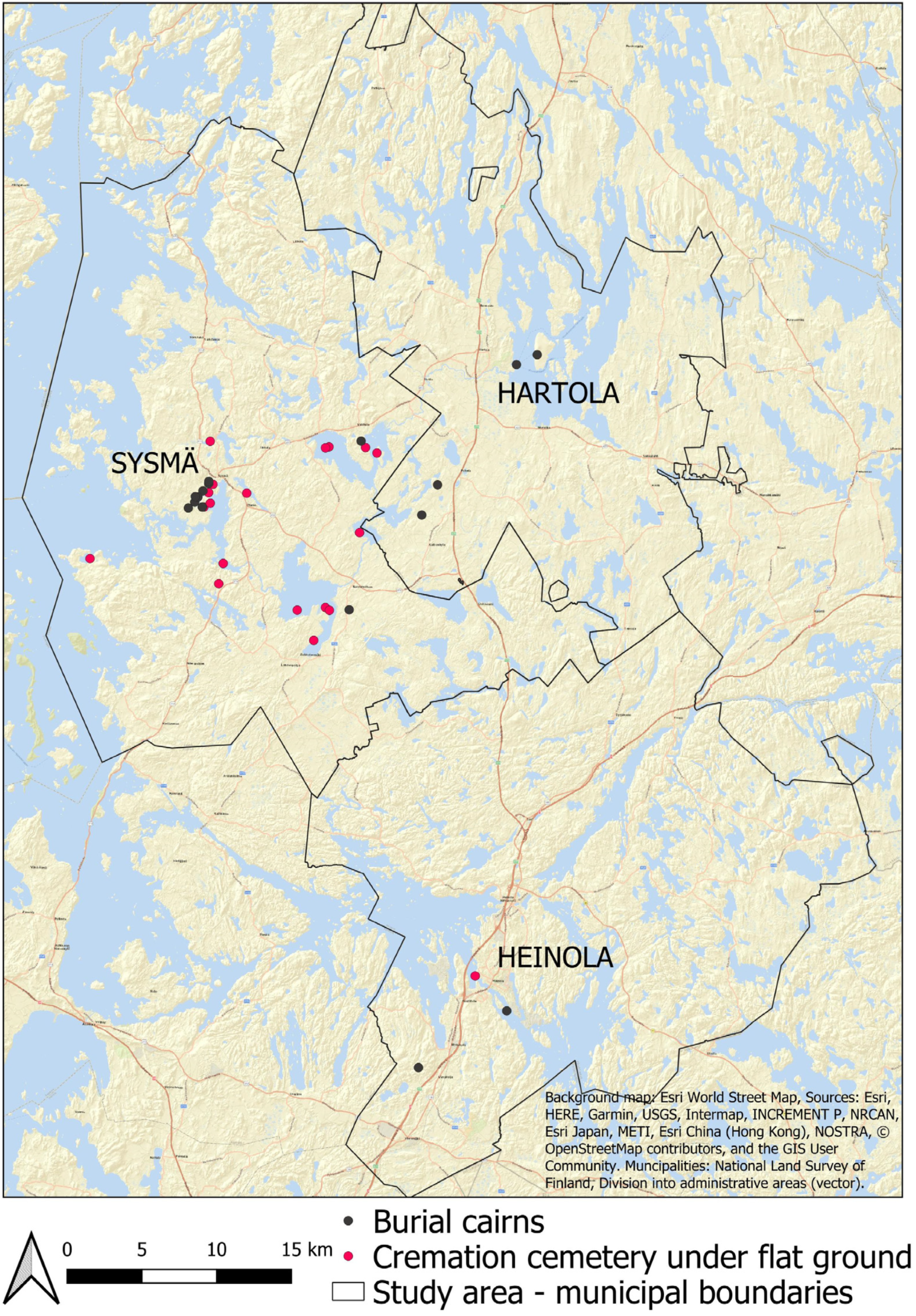
One very interesting phenomenon in the research area is the distribution of Iron Age cemetery sites (Figure 6). Sites including possible burial cairns seem to be located inside or very near those possible settlement areas. Many of them include dozens, or even more than a hundred, low and carefully formed cairns. However, the interpretation of these sites is difficult. The study area is also known for slash-and-burn agriculture, and some of the sites and cairns may be related to previous agricultural activities. Another Iron Age cemetery type in the area is called a cremation cemetery under flat ground (polttokenttäkalmisto). The problem with this site type is that the sites in Itä-Häme do not seem to match the usual description of that special type of cemetery. Based on their location, those sites are strongly associated with water; many of the sites are found on small islands or very close to the water. However, many of these sites are new discoveries, which explains why they have not yet been thoroughly studied.
4. Discussion
Adding keywords had a great impact on the usability of the register. Without the ready-made keywords, it would have required hours of extra work to find the needed information manually, as shown in these examples from the register, where one would have to read all the necessary reports and add the sites on the map (or Excel list) one by one. As an example, the current register includes more than 35,000 protected archaeological sites (kiinteä muinaisjäännös) in Finland. The search for the “Stone Age” category gives a list of about 11,000 sites in Finland, most of which fall under the “settlement site” definition. Consequently, if a researcher wishes to find Comb Ware sites in Finland, they would need to read through all of the site descriptions and reports, sifting through approximately 11,000 sites. The lack of detailed information in the current register makes it impossible to conduct targeted searches. Additionally, if the study area is extensive, the time required for the search would be significantly increased. For both researchers and museum authorities, the biggest impact would be saving working time and effort that is otherwise spent on manual searching and reading. Once the keywords are added, everyone can use them, which would also prevent researchers or authorities from duplicating the work while trying to find similar items in the register. If the “Keywords” tab were added to the internet version of the register, it would significantly enhance the usability of the register, especially for users who are not familiar with GIS programs or querying data from the vector file. Having the option to view the results in the map window would be beneficial as well. If there were a demand for using keywords when reporting field studies in the future, it could also enhance the research aspect of the fieldwork. If researchers were encouraged to provide more precise dating in keywords, it could inspire them to make more interpretations. The same applies to site types, finds, and possible cultural definitions.
According to FAIR principles, data should be maintained in a reusable format. The characteristic information, metadata, and attributes associated with the material are essential to the versatile use of such data [4]. The register of ancient sites includes a very limited number of such attributes, and this limits the reusability of the data significantly. The addition of characteristic attributes does not solve the most central problem in the Finnish archaeological data records: archaeological research itself is performed with limited resources and quite rarely. The limited resources especially affect the quantity and quality of the different analytical methods utilized, and even some basic analytical methods, such as radiocarbon dating, are very often skipped. However, the metadata of the register and the classification of the sites should be based on reliable research data. The process of creating good metadata about cultural heritage can be a multifaceted project [34]. Adhering to FAIR principles is a good goal, but principles alone do not make the data better. Therefore, active research is needed to produce high-quality and trustworthy metadata. If the register is used for research purposes, metadata is also needed so that the researchers can assess the reliability and suitability of the given information from the perspective of their research use. Based on the current study, the register is also poorly suited to, for example, spatial data analyses, because the coordinate data cannot be trusted. Many research reports are short, and the Finnish Museum Agency’s practice of only accepting small-size (50 MB) PDF reports reduces their quality even more. A list-like report without essential information and analysis does not provide a sufficient basis for the versatile reuse of the material. The seemingly common practice of keeping interpretation to a minimum in reports can also contribute to weakening the ability to reuse the material. If the researcher who completed the field study does not make interpretations of the site that he/she studied, making such interpretations will certainly not be easier for another researcher who reads and interprets the report in the future.
Through this paper, we would like to raise awareness about these issues and FAIR principles. The reusability of data should already be considered when planning and conducting fieldwork. How we perform the research in the field, and which analyses the researcher does or does not do, have major effects on future research. Being aware of the FAIR principles from the very beginning and planning work according to those principles, would support future data reuse. If the analysis cannot be performed because of a lack of resources, it would be essential to save some material for the future so that it could be analysed later. Unfortunately, the Finnish Heritage Agency does not accept or save samples; only the finds are kept safe. The Finnish Heritage Agency has been updating quality guidelines for archaeological fieldwork [9] and, in the future, these guidelines could include instructions on how FAIR principles could already be taken into consideration in the fieldwork phase.
Adding keywords based on previous research would, of course, improve the register, but the key question is: should the register be reusable for research purposes, and for wider audiences? If the register is intended mainly for the authorities’ use, then adding keywords would not provide so much new and important information compared to the effort that the updating itself would take. Another topic that should be discussed is how much detailed information is needed in the future. For example, is it important to distinguish between cup-marked stones and cup-marked bedrock, and how detailed should the find descriptions and categories be when using them as keywords? It is clear that such a job could not be performed as one big update, both because of the size of the database and partly because of the extent of mistakes that should be fixed as part of the process. Instead of one big project, the update could be performed on a step-by-step basis, starting with smaller issues, and perhaps working together with the provincial museum authorities. An excellent example of a modern database is Löytösampo—Find Sampo [35]. This portal is focused on metal detector finds and so does not provide much information about the archaeological sites that were the primary focus of this research, which is why it was not previously mentioned in this study. However, the Löytösampo portal could be used as a model if or when the register of ancient sites is updated.
Before adding keywords to the register, many technical issues would require more discussion and research. For example, some general guidelines would be needed to decide what constitutes important information and should be used as keywords. Manually collecting keywords by having researchers read all the reports and find information from catalogues and the database would consume a significant amount of time, and well-defined guidelines would be necessary to support this effort. Even if an automatic process becomes feasible in the future, human intervention would still be required to distinguish between relevant and irrelevant information. This is especially true for older reports, which may include narrative content more akin to ‘traveling journal’ entries than scientific reports. Challenges would also arise with more recent, very concise reports where the most pertinent information might consist of just a single word. One challenge for the future is also the PDF format. Many old reports are originally handwritten and might also include drawings. Consequently, these reports would initially need automatic text recognition and digitization to be converted into a digital format. For example, the READ project [36], in which the National Archives Finland is a partner, aims to enhance accessibility to archival materials by utilizing new digitization technologies. Another intriguing avenue for the future would involve exploring word embedding techniques. Similarities of archaeological sites could be searched for in excavation reports using the Natural Language Processing (NLP) technique, as a very recent study establishes [37]. However, the database system itself could also benefit from technical improvements, as the current system is quite incoherent. Further technical studies could be conducted, focusing on the database and different techniques, such as the semantic integration of heterogeneous data [38]. Our digital data is important, as it is a part of our cultural heritage that digital libraries are preserving [39]. As Oikarinen also summarizes [40], archaeological reports and data could be analysed from a database and information systems perspective, or even from a broader interdisciplinary perspective.
It is clear that the water route connecting the two largest lakelands in Finland (Päijänne and Saimaa) has been very important for a long time, and is the reason Sysmä could be defined as one of the Iron Age centres of Finland. The presence of rich finds and large settlement areas also give the impression of an established trade network. Already in 2005, archaeologist M. Miettinen, who has performed fieldwork in Itä-Häme, wrote that sites and finds from Sysmä clearly indicate a remarkable Iron Age settlement [41]. She dates the beginning of the settlement in Sysmä to the Merovingian period (600 AD) at the latest, based on the finds and one pollen analysis that suggests that more intense agriculture started at that time in Sysmä. One of the best-known Iron Age sites in Sysmä is called Ihananiemi [21]. As Miettinen points out, the finds from the site are exceptionally rich; for example, almost all buckle types known from the end of the Iron Age in Finland are represented in the finds collected from Ihananiemi. Based on the finds, she interprets the site as having been a central settlement, marketplace, or some type of “market town”. Miettinen also ponders why there are many find types in Sysmä that have their origin in the eastern cultures. Despite this work, it is clear that more research is needed before the possible village areas described in this paper can be confirmed. The areas are located along an important communication route, which could be the main reason settlements were established in the region. It is also possible that accommodation and places to stay overnight would have been needed along this long route, and the many villages or settlements in the region would have benefitted the traders’ and travellers’ regular visits. The residents of the settlements could also have exerted control of the route and any associated trade due to their location along the rivers and lakes. Heinola was located further from the main route, and that could be one reason there are fewer Iron Age sites there. However, modern land use has also been more intense in the Heinola area, since it is a small city, and the building activity could have destroyed the remains of previous land use, especially in the city centre. It should also be noted that there are areas in Itä-Häme where archaeological surveys have not been carried out so extensively, although some areas have been much better studied lately. This research bias should also be considered while interpreting the results of this study. Many more sites may still be undiscovered, and more surveys are needed, especially in those cases where identified sites do not have any area definition (polygon) at all.
The study area’s different possible cemetery types are also an interesting research question. The problem with cemeteries with cairns is their identification. Based on the site descriptions, the interpretation part of those structures often seems uncertain. The interpretations could also have been influenced by the working methods of different eras, and past perceptions of what kind of ancient remains should be found in the area. Especially in the older surveys, the short written site descriptions do not reveal the background of the interpretation or why the researcher has concluded what was presented in the report. One cairn was excavated in Hartola Kotisalo in 2003, but the interpretation of the site still remained unclear [42]. To distinguish different types of cairns, more excavations would be needed, both of cairns interpreted as related to cultivation and possible burial cairns of the Iron Age. It was interesting to note that possible cemetery sites, including many cairns, are located in or very near possible settlement areas. This could indicate that those sites are indeed cemeteries, perhaps burial places used by small village communities, clans, or families. Those sites that are near the possible Iron Age settlement areas should especially be studied more carefully in the future.
Even more interesting are the very recent discoveries of cremation cemeteries under flat ground. This cemetery type is well described and defined in a master’s thesis from 2013 [43]. According to the thesis, this type of cemetery can be distinguished by five different elements: a stone pavement under the soil, soil stained with dark soot, cremated bones, grave goods, and a large size. The sites are often located in moraine hills. The sites in the Itä-Häme area are very small, and the location of these sites is completely different. The sites in Itä-Häme are located on the island and very close to the water. It is possible that these sites may include only one, or perhaps a few, cremation burials. The problems of defining these cremation cemeteries under flat ground were also discussed in 2003 [44]. It must be noted that the area on which the master’s thesis was focused is located almost 250 km away from Itä-Häme. However, burials on an island or near the water were not a new custom in Iron Age Finland. The locations of these sites in Itä-Häme seem somewhat similar to Lapp cairns from the Bronze Age. As a recent fundamental study of Lapp Cairns suggests, the view of the lake and open water around the burial place could have been important factors when choosing the location [45]. One interesting point that Miettinen makes [36] is that the site called Haapasaari [46] in Sysmä is located so low and near the lake that it may have been underwater from time to time. The finds from the site are from the Viking period. An article published in 2022 describes a burial that has some similarities with the island burials in Itä-Häme [47]. In that case, the burial is from the Merovingian period, and is also located on an island. As the article excellently summarizes, more discussion and research are needed about the Iron Age burial types in different regions of Finland. It is possible that the phenomenon described here is a new site type or local subtype of the cremation cemeteries under flat ground. Some of the sites in the study area that are classified as find places may actually be this poorly known type of burial site; the location of some of the find places suggests that they could be part of the same phenomenon. Another interesting fact is that two of the islands where these burial sites are found are called “carcase islands” (raatosaari).
Using ontologies and structured keywords is, of course, important, and should be considered, but on the other hand, ready-made strict categories leave very little room for new interpretations. Critical reviews of using ontologies in archaeology are also needed [48]. New types of ancient remains can still be discovered, and new observations can still be made, because archaeological research in Finland is still “lacking knowledge” and basic research. Adherence to a strict classification system can contribute to a lack of perception of these possible new observations or phenomena, which are not well known enough to fit into the existing system. In addition, especially regarding the Iron Age, research has long focused on Southwest Finland. Transferring the same classifications to other areas that are geographically distant can be problematic, as the example of those island cemeteries established. Focusing research on a limited area creates a bias and can lead research along the wrong track. One such problematic group are those finds or artefacts that were found decades ago and which are now stored, for example, in small local museums. These finds are not part of the register, nor are they mentioned anywhere in the register. Some of the objects do not have any find coordinates or other accurate information about where they were found. However, many of those finds are from sites that are in the register today, and many are significant. Clues regarding these old finds can be found, for example, in old local history books [18], and sometimes just in personal communications or discussions with local residents. The register also does not include or mention any research papers or thesis work. It is mostly up to the researcher how well he or she can find those relevant publications. This can be challenging, for example for students, and is an even bigger problem for general public users; for instance, metal detecting is legal in Finland, and many metal detector hobbyist perform their research using the register.
This study revealed significant errors and incoherent information throughout the entire database system—but also information on carefully conducted, interesting field studies, and potential research questions for future research. In the future, it would be interesting to test the use of keywords for research on the Stone Age or, especially, for the historical period. A similar test on a new period could reveal new information about both the area and the period, as well as the ambiguity of the register. In the future, the study of this geographical research area could also be expanded. In particular, the inclusion of other neighbouring municipalities, such as Asikkala, could significantly supplement the settlement picture of Iron Age Itä-Häme. A special topic for further research could be a new site type or subtype. Are similar phenomena found elsewhere, and have they been studied through excavations, for example? It is difficult to find this information in the register, as the sites may have been classified in many different ways. It is, indeed, one of the main problems with the register, as it is currently difficult to find similarities or differences in the register data. The revised Antiquities Act can still change the situation in many ways, and we look forward to discussing this topic in the future.
5. Conclusions
The reusability of archaeological data sets the framework for future research. FAIR principles are important, but active and high-quality archaeological research is equally important. The reusability of archaeological data can be improved in different ways, such as by adding search options and keywords, but this alone is not enough if the basic archaeological research is insufficient. Future high-quality archaeological work in Finland will be made possible not only by its rich past, but also by promoting active research and all of the associated best practices.
Author Contributions
Conceptualization, J.R. and M.H.; methodology, J.R.; software, J.R.; validation, J.R.; formal analysis, J.R.; investigation, J.R.; resources, J.R.; data curation, J.R.; writing—original draft preparation, J.R.; writing—review and editing, J.R. and M.H.; visualization, J.R.; supervision, M.H.; project administration, J.R.; funding acquisition, J.R. and M.H. All authors have read and agreed to the published version of the manuscript.
Funding
This research was funded by Kone Foundation, grant number 202006680 and The APC was funded by the University of Helsinki.
Data Availability Statement
Data available in a publicly accessible repository that does not issue DOIs. Publicly available datasets were analysed in this study. This data can be found here: https://www.museovirasto.fi/en/services-and-guidelines/data-systems/kulttuuriympaeristoen-tietojaerjestelmae/kulttuuriympaeristoen-paikkatietoaineistot (accessed on 17 August 2023).
Acknowledgments
Anna Wessman, Sami Raninen, Niko Anttiroiko, Sirkka-Liisa Seppälä and Eljas Oksanen, thank you for your support and inspiring discussions. Open access funding provided by University of Helsinki.
Conflicts of Interest
The authors declare no conflict of interest.
References
- Nicholson, C.; Kansa, S.; Gupta, N.; Fernandez, R. Will It Ever Be FAIR?: Making Archaeological Data Findable, Accessible, Interoperable, and Reusable. Adv. Archaeol. Pract. 2023, 11, 63–75. [Google Scholar] [CrossRef]
- Löwenborg, D.; Jonsson, M.; Larsson, A.; Nordinge, J. A Turn Towards the Digital: An Overview of Swedish Heritage Information Management Today. Internet Archaeol. 2021, 58. [Google Scholar] [CrossRef]
- Matsumoto, M.; Espen Uleberg, E. Curation of Digital Archaeological Data in Norway. Internet Archaeol. 2021, 58. [Google Scholar] [CrossRef]
- Fairdata. Available online: https://www.fairdata.fi/tietoa-fairdatasta/fair-periaatteet/ (accessed on 7 August 2023).
- ADRIANEplus. Available online: https://ariadne-infrastructure.eu/ (accessed on 27 February 2023).
- Europeana Archaeology. Available online: https://pro.europeana.eu/project/europeana-archaeology (accessed on 27 February 2023).
- Transforming Data Re-Use in Archaeology (TETRARCHs). Available online: https://www.mola.org.uk/tetrarchs (accessed on 27 February 2023).
- Anttiroiko, N.; Seppälä, S.-L. Muinaisjäännösrekisterin Kehittämisen Esiselvitys 2022; Nykytilan arvio ja Kehittämistarpeita, Kulttuuriympäristöpalvelut, Museovirasto; Report by Finnish Heritage Agency: Helsinki, Finland, 3 February 2023. [Google Scholar]
- Suomen Arkeologisten Kenttätöiden Laatuohjeet. Available online: https://www.museovirasto.fi/fi/kulttuuriymparisto/arkeologinen-kulttuuriperinto/arkeologisen-kulttuuriperinnon-tutkimus/arkeologisten-kenttatoiden-laatuohjeet (accessed on 21 March 2023).
- Soisalo, J.; Roiha, J. Kiukainen Culture Site Locations—Reflections from the Coastal Lifestyle at the End of the Stone Age. Land 2022, 11, 1606. [Google Scholar] [CrossRef]
- Muinaisjäännösrekisteri. Available online: https://www.kyppi.fi/palveluikkuna/mjreki/read/asp/r_default.aspx (accessed on 21 March 2022).
- Kulttuuriympäristön Palveluikkuna. Available online: https://www.kyppi.fi/palveluikkuna/portti/read/asp/default.aspx (accessed on 21 March 2023).
- Museoviraston Asiat. Available online: https://asiat.museovirasto.fi/home (accessed on 21 March 2023).
- Hamari, P. Muinaisjäännösrekisterin uudistuksia Museovirastolla. Muinaistutkija 2003, 3, 25–36. [Google Scholar]
- Haimila, M. Muinaisjäännösrekisteri 20 vuotta myöhemmin—Muinaisjäännösrekisterin lyhyt historia. In Arkeologia Suomessa—Arkeologi i Finland 2008–2009; Ranta, H., Nurminen, T., Tenhunen, T., Niukkanen, M., Eds.; Museovirasto: Helsinki, Finland, 2012; pp. 25–33. [Google Scholar]
- Lahden Museot—Kulttuuriympäristö. Available online: https://www.lahdenmuseot.fi/vastuumuseo/kulttuuriymparisto/ (accessed on 18 April 2023).
- Salovius, R.K. Muinaisjäännöksiä ja Muistoja Heinolan Kihlakuntaan Kuuluvissa Heinolan ja Sysmän Pitäjissä; Archaeological Report. 1897. Available online: https://www.kyppi.fi/to.aspx?id=129.146498 (accessed on 28 March 2023).
- Juvelius, E.K. Sysmän Pitäjän Historia; Etelä-Suomen Sanomain kirjapaino Oy: Lahti, Finland, 1925; pp. 15–29. [Google Scholar]
- Hackman, A. Sysmä Karilanmaa Nuuttila Supittu Hautaröykkiön Kaivaus; Excavation Report. 1920. Available online: https://www.kyppi.fi/to.aspx?id=129.141274 (accessed on 28 March 2023).
- Sysmä—Siivolanpelto. Available online: https://www.kyppi.fi/to.aspx?id=112.781010049 (accessed on 18 April 2023).
- Sysmä—Ihananiemi. Available online: https://www.kyppi.fi/to.aspx?id=112.781010021 (accessed on 18 April 2023).
- VARK—Valtakunnallisesti Merkittävät Arkeologiset Kohteet. Available online: https://www.museovirasto.fi/fi/kulttuuriymparisto/arkeologinen-kulttuuriperinto/valtakunnallisesti-merkittavat-arkeologiset-kohteet-vark (accessed on 19 April 2023).
- Hartola—Vuoteela. Available online: https://www.kyppi.fi/to.aspx?id=112.81010001 (accessed on 18 April 2023).
- Aartolahti, A. Rautakauden Sysmässä asutusyksiköitä metsästämässä. Muinaistutkija 2011, 2, 26–35. [Google Scholar]
- Hartola—Kermamäki. Available online: https://www.kyppi.fi/to.aspx?id=112.81010004 (accessed on 26 April 2023).
- Hartola—Kotisalo. Available online: https://www.kyppi.fi/to.aspx?id=112.81010011 (accessed on 26 April 2023).
- Hartola—Hiekkaniemi. Available online: https://www.kyppi.fi/to.aspx?id=112.81010005 (accessed on 26 April 2023).
- Miettinen, T.; Miettinen, P. Hartola Inventointi 1967. Survey Report. Available online: https://www.kyppi.fi/to.aspx?id=129.135400 (accessed on 26 April 2023).
- Heinola—Rautaportti. Available online: https://www.kyppi.fi/to.aspx?id=112.1000034808 (accessed on 26 April 2023).
- Heinola-Iso-Palpanen. Available online: https://www.kyppi.fi/to.aspx?id=112.1000006186 (accessed on 26 April 2023).
- Jansson, J. Tainionvirta Itä-Hämeessä. Rautakautinen valtatie. Hiisi 2010, 2, 7–10. [Google Scholar]
- Tikkala, E.; Taipale, P.; Sorvali, E. Päijät-Hämeen Maakuntakaava, Historiallisen Ajan Muinaisjäännösten Inventointi; Survey Report; Lahden Kaupunginmuseo: Lahti, Finland, 2012. [Google Scholar]
- Roiha, J.; Heinaro, E.; Holopainen, M. The Hidden Cairns—A Case Study of Drone-Based ALS as an Archaeological Site Survey Method. Remote Sens. 2021, 13, 2010. [Google Scholar] [CrossRef]
- Papatheodorou, C. On cultural heritage metadata. Int. J. Metadata Semant. Ontol. 2012, 7, 157–161. [Google Scholar] [CrossRef]
- Löytösampo. Available online: https://dev.loytosampo.fi/en/ (accessed on 6 May 2023).
- READ. Available online: https://eadh.org/projects/read (accessed on 15 August 2023).
- Sakahira, F.; Yamaguchi, Y.; Terano, T. Understanding Cultural Similarities of Archaeological Sites from Excavation Reports Using Natural Language Processing Technique. J. Adv. Comput. Intell. Intell. Inform. 2023, 27, 394–403. [Google Scholar] [CrossRef]
- Bergamaschi, S.; Castano, S.; Vincini, M.; Beneventano, D. Semantic integration of heterogeneous information sources. Data Knowl. Eng. 2001, 36, 215–249. [Google Scholar] [CrossRef]
- Barbuti, N. Thinking digital libraries for preservation as digital cultural heritage: By R to R4 facet of FAIR principles. Int. J. Digit. Libr. 2021, 22, 309–318. [Google Scholar] [CrossRef]
- Oikarinen, T. Archaeological Grey Reports—Current Issues and Their Potential for the Future. In Sounds Like Theory; Ikäheimo, J., Salmi, A.-K., Äikäs, T., Eds.; XII Nordic Theoretical Archaeology Group Meeting in Oulu; Monographs of the Archaeological Society of Finland: Helsinki, Finland, 2014; Volume 2, pp. 187–197. [Google Scholar]
- Miettinen, M. Sysmän kirkonseudun ja Jämsänjokilaakson rautakausi uusien löytöjen valossa. In Kentältä Poimittua 6; Ranta, H., Ed.; Museovirasto: Helsinki, Finland, 2005; Volume 11, pp. 78–95. [Google Scholar]
- Lahelma, A. Hartola Kotisalo, Röykkiö n:o 13, Arkeologinen Kaivaus Rautakautisella Muinaisjäännösalueella 2003. Lahden Kaupunginmuseo, Päijät-Hämeen Maakuntamuseo; Excavation Report. Available online: https://www.kyppi.fi/to.aspx?id=129.125545 (accessed on 11 May 2023).
- Rohiola, V.-M. Polttokenttäkalmiston Ominaisuudet ja Rakenne—Tutkimuskohteena Laitilan Vainionmäen Viikinkiaikainen B-kalmisto. Master’s Thesis, University of Helsinki, Helsinki, Finland, 2013. [Google Scholar]
- Wickholm, A.; Raninen, S. Rautakautinen riesa—Polttokenttäkalmistojen problematiikkaa. Muinaistutkija 2003, 2, 2–14. [Google Scholar]
- Sapio, J. Lapp cairns Spatial and Cultural Context of Early Metal Period Stone Structures in the Finnish Lake District. Ph.D. Thesis, University of Helsinki, Helsinki, Finland, 2023. [Google Scholar]
- Sysmä—Haapasaari. Available online: https://www.kyppi.fi/to.aspx?id=112.781010082 (accessed on 11 May 2023).
- Moilanen, U.; Raninen, S. Merovingiaikainen polttohauta Kihniön Pyhäniemessä. Muinaistutkija 2022, 2, 24–30. [Google Scholar]
- Preucel, R. The Predicament of Ontology. Camb. Archaeol. J. 2021, 31, 461–467. [Google Scholar] [CrossRef]
Figure 1.
The study area, consisting of the three municipalities Sysmä, Hartola, and Heinola. The area is referred to as Itä-Häme in this paper.
Figure 1.
The study area, consisting of the three municipalities Sysmä, Hartola, and Heinola. The area is referred to as Itä-Häme in this paper.

Figure 2.
Sites that have been interpreted as being related to the Iron Age in this study.

Figure 3.
Possible Iron Age villages in the study area, and the river route that connected Päijänne and Saimaa lakes.
Figure 3.
Possible Iron Age villages in the study area, and the river route that connected Päijänne and Saimaa lakes.

Figure 4.
The distribution of four different find types in the study area: (A) swords, (B) spearheads, (C) coins, and (D) buckles.
Figure 4.
The distribution of four different find types in the study area: (A) swords, (B) spearheads, (C) coins, and (D) buckles.

Figure 5.
The locations of cup-marked stones and cup-marked bedrock in the study area.

Figure 6.
The locations of burial cairns and cremation cemeteries under flat ground in the study area.
Figure 6.
The locations of burial cairns and cremation cemeteries under flat ground in the study area.

Disclaimer/Publisher’s Note: The statements, opinions and data contained in all publications are solely those of the individual author(s) and contributor(s) and not of MDPI and/or the editor(s). MDPI and/or the editor(s) disclaim responsibility for any injury to people or property resulting from any ideas, methods, instructions or products referred to in the content. |
© 2023 by the authors. Licensee MDPI, Basel, Switzerland. This article is an open access article distributed under the terms and conditions of the Creative Commons Attribution (CC BY) license (https://creativecommons.org/licenses/by/4.0/).
Share and Cite
MDPI and ACS Style
Roiha, J.; Holopainen, M. Digging through Databases—A Case Study of Iron Age Sites in Finland by Generating and Analysing Keywords. Heritage 2023, 6, 5919-5934. https://doi.org/10.3390/heritage6080311
AMA Style
Roiha J, Holopainen M. Digging through Databases—A Case Study of Iron Age Sites in Finland by Generating and Analysing Keywords. Heritage. 2023; 6(8):5919-5934. https://doi.org/10.3390/heritage6080311
Chicago/Turabian StyleRoiha, Johanna, and Markus Holopainen. 2023. "Digging through Databases—A Case Study of Iron Age Sites in Finland by Generating and Analysing Keywords" Heritage 6, no. 8: 5919-5934. https://doi.org/10.3390/heritage6080311