

Investigations at the Heereskraftfahrpark (HKP) 562 Forced-Labor Camp in Vilnius, Lithuania
by
 ,
,
Philip Reeder
1,*,
Harry Jol
2,
Richard Freund
3,
Alastair McClymont
4,
Paul Bauman
4 and
Ramūnas Šmigelskas
5 1
Center for Environmental Research and Education, Bayer School of Natural and Environmental Sciences, Duquesne University, Pittsburgh, PA 15282, USA
2
Department of Geography and Anthropology, University of Wisconsin-Eau Claire, Eau Claire, WI 54702, USA
3
Department of Philosophy and Religion, Christopher Newport University, Newport News, VA 23606, USA
4
BGC Engineering, Inc., Calgary, AB T2E 7W6, Canada
5
Academy of Cultural Heritage, Dominikonų Street 15/1, LT-01131 Vilnius, Lithuania
*
Author to whom correspondence should be addressed.
Heritage 2023, 6(1), 466-482; https://doi.org/10.3390/heritage6010024
Submission received: 25 November 2022
/
Revised: 27 December 2022
/
Accepted: 30 December 2022
/
Published: 3 January 2023
(This article belongs to the Special Issue Archaeological and Geoarchaeological Heritage and Its Dissemination)
Abstract
:This research, examining the site of the HKP Forced-Labor Camp in Vilnius, Lithuania, located and better defined the characteristics and remaining features of the 1944 camp. There were four over-arching objectives for this research. First, to find the entrance into the principal hiding place where Jews interned in the camp took refuge just before the camp’s liquidation by the Nazis and their local collaborators. Next, find the location of the burial trench(es) where Jewish prisoners who were found in hiding were murdered and initially buried. Next, to find the mass-burial site where Jewish survivors reburied the remains from the trench(es). Lastly, to locate any other evidence related to the murder of Jews at the HKP 562 site. Ground-Penetrating Radar (GPR) found the principal hiding place in the basement of Building 2. Electrical Resistivity Tomography (ERT) discovered the two trenches where camp inhabitants who were shot on-site during liquidation were first buried. ERT also found the location of the mass grave that holds the reburied remains from the trenches. Bullet-scarred walls near the burial trenches indicate where the Jews were shot on-site. This research solved one of the thousands of unknowns about the Holocaust, using geoscience to uncover forgotten and hidden history. The materials and methodologies used in this research can be applied in uncovering this history at thousands of other Holocaust and genocide sites worldwide.
1. Introduction
Geoarchaeology is a sub-field of archaeology and geoscience that uses techniques from geosciences to examine topics that inform archaeologic and historic knowledge [1,2]. Our research uses geoscience (mostly geophysics) to assist in writing/rewriting the history of Holocaust sites [3,4]. Many Holocaust sites are not systematically studied because very little is known about them, and much remains undiscovered. Some of these known sites possess numerous unknowns about what happened in these places [5]. That is the case with the German Army Motor-Vehicle-Repair Park 562 (German translation: Heereskraftfahrpark (HKP) 562), which is east of the Jewish Ghetto in Vilnius, Lithuania (Figure 1). HKP 562 (hereafter, HKP) was a forced-labor camp where Jewish men repaired Nazi Army vehicles. What makes this place unique in the realm of Nazi forced-labor camps and the Holocaust is the intent behind its inception, operation, and eventual closure.
Jewish men who worked at the vehicle repair facilities in Vilnius were transferred from the Jewish Ghetto to HKP to be closer to their work location, beginning in September 1943. The Nazi officer in charge of the direct day-to-day operations at HKP (Major Karl Plagge) argued to his superiors that the workers would be more enthusiastic and work harder if they could have their families stay with them at the camp. Plagge’s vision for HKP was to be a more-or-less self-contained operation that was much more than just a place to repair Nazi vehicles. In Plagge’s mind, it was a humanitarian effort to preserve Jewish lives [6]. Plagge acted out of humanitarian principles, but this was not because he was inherently opposed to Nazism. Plagge, a World War I veteran, joined the National Socialist German Workers’ Party (later known as the Nazi Party) in 1931 to be a part of the effort to rebuild Germany following the economic collapse after World War I.
The workers at HKP were certified by Plagge as skilled mechanics, although most possessed no knowledge of vehicle repair. Being certified meant they were not subject to being removed from the Vilnius Ghetto to be murdered. The Jewish men who were selected to go to HKP learned on the job. They quickly developed expertise that fooled Plagge’s superiors and made HKP a successful operation for repairing Nazi vehicles. In January 1944, the Nazi commanders controlling operations in Vilnius demanded that Plagge remove the women and children from HKP because they spent their days sitting idle. The plan was to send the women and children to the Kaunas Concentration Camp, about 100 km west. Instead, Plagge set up sewing workshops at HKP to put the women and children to work, repairing and sewing clothing for the Nazi war effort, which temporarily appeased his superiors.
All changed at HKP in March 1944 while Plagge was away from the camp visiting his family in Germany. The Nazis removed as many children as they could find from HKP and murdered them in the nearby forest. Then, in early July 1944, the Nazis and their local collaborators attempted a total liquidation of the over 1000 remaining inhabitants in the camp [6,7,8]. Just before the liquidation, about half of the remaining inhabitants went into prepared hiding places. The Nazis and local collaborators murdered all Jews they located upon arrival, taking them to the nearby forest to be shot [9,10]. This forest goes by several different names in the Holocaust literature for Lithuania. Ponar, as it was known to Vilnius’s Yiddish-speaking Jewish community, or Ponary in Polish, and Paneriai in Lithuanian, are all acceptable for identifying this site (see Figure 1). For this paper, we use Ponary, which seems to be the most common usage. All persons the Nazis could find in their hiding places during the liquidation of the camp were shot on-site. Approximately 200 Jews emerged from hiding when the (Soviet) Red Army [6,7,11,12] liberated the camp.
Using geophysical analysis [9,13,14] at the HKP site, this research intended to locate and better define the characteristics and remaining features of the 1944 camp before urban renewal destroys the site. For example, the location of the principal hiding place, where the Jews took refuge just before the camp’s liquidation, is unknown. In addition, the location of the trenches or the mass grave remains unknown. This research attempts to solve one of the thousands of unknowns about the Holocaust, using geoscience to uncover forgotten and hidden history. The materials and methodologies used for this research apply to finding this history at thousands of other Holocaust and genocide sites around the world [15,16,17].
Expanded Historical and Cultural Context
The Holocaust represents an extreme moral low in human history. The murder of men, women, children, the old, the young, and the middle-aged by the Nazis and collaborators destroyed families and their culture. An estimated 17 million people were murdered between 1933 and 1945, according to the United States Holocaust Memorial Museum (USHMM) [18]. The German SS (Schutzstaffel—Special Police Force) [19], their Einsatzgruppen (special action mobile killing groups who followed the German army as it invaded and occupied countries in Europe) [20], and local collaborators killed an estimated 3 million Jews, and other undesirables, at the Auschwitz-Birkenau, Sobibor, Belzec, and Treblinka extermination camps alone [21,22]. The undesirables included Romani Travelling communities, Jehovah’s Witnesses, homosexuals, Black people, the physically and mentally disabled, political opponents, dissenting clergy, resistance fighters, prisoners of war, Slavic peoples, and individuals from artistic communities [23].
In Lithuania, the so-called “Holocaust by Bullets” started in June 1941. The murder of Jews at the Operation Reinhard camps (Belzec, Sobibor, and Treblinka) [22,23], mainly by gassing, did not begin until March 1942. Before establishing these killing centers, the preferred method of murder was by shooting [24]. By early 1941, the Jewish population of Lithuania increased because of an influx of refugees from German-occupied Poland, and it reached nearly 250,000, about 10 percent of the total population. By late August 1941, the Nazis and collaborators had shot most Jews in rural areas and, by November 1941, had killed many Jews in ghettos in larger cities such as Vilnius. By the time Red Army troops reoccupied Lithuania in July 1944, the Germans had murdered about 90 percent of the Jews in Lithuania, one of the highest victim rates in Europe [24].
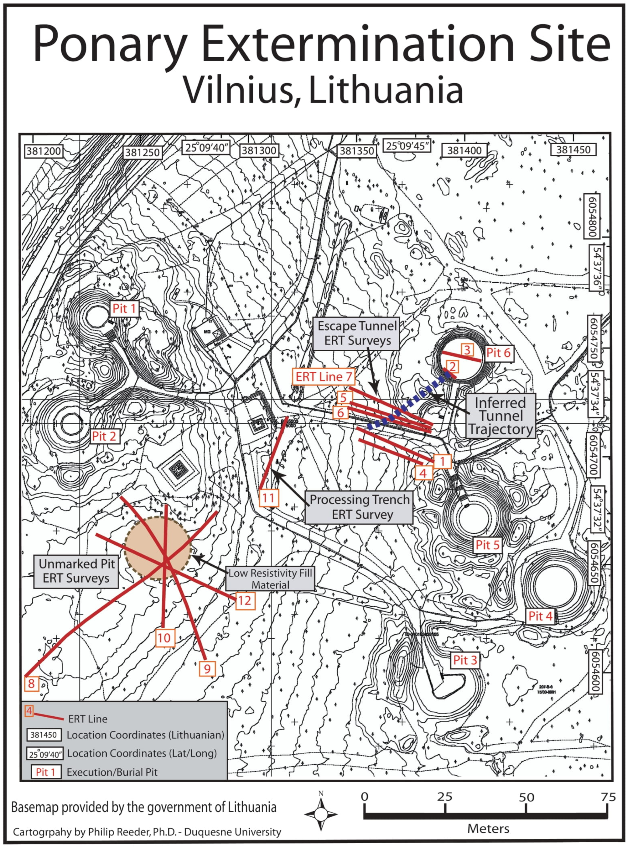
Amidst the Jewish misery of the Holocaust, there are few stories of triumph. However, two small victories did occur amongst all the tragedies in the vicinity of Vilnius. One happened at the Nazi extermination center in the Ponary Forest in March 1944. This forest was where the children from HKP and the adult men and women, as part of the camp liquidation, were sent. In total, approximately 70,000 Jews and 30,000 undesirables died at Ponary at the hands of the Nazis and local collaborators between July 1941 and July 1944. The camp was at a former Soviet fuel depot under construction when the Nazis occupied Lithuania. The Nazis converted this site in the forest about 12 km southwest of the Vilnius Ghetto into a facility whose sole purpose was the murder and burial of Jews and undesirables. Figure 2 is a map of the camp and related facilities, compiled from the fragments of evidence that still exists about the area. The core area is where pits dug by the Soviets to house fuel tanks became the focus of the murder and burial operations at the site [10]. The Lithuanian government has memorialized six of these pits at Ponary. However, our research team discovered one additional pit as part of research at the site in July 2016 that has not yet been memorialized [9,10].
With the loss of the war imminent, and the Red Army inching closer from the west, in late September 1943, Nazi officials sent a group of 80 Jewish prisoners to Ponary to dig up the bodies of the victims, burn them, and then rebury the ashes, in an attempt to hide the atrocities that occurred there. The Jewish prisoners—knowing their eventual fate when their work was done—dug an escape tunnel every night for three months. On 15 April 1944, 40 prisoners escaped through the 35-m-long tunnel, but guards killed many escapees seen in the surrounding forest. Fifteen eluded the guards, and eleven joined with the partisans in the Rudniki Forest and survived the war [9,25]. Using the geophysical technique of Electrical Resistivity Tomography (ERT), the existence and location of this escape tunnel were verified [9,10]. Figure 2 presents the location and geographic context of the tunnel.
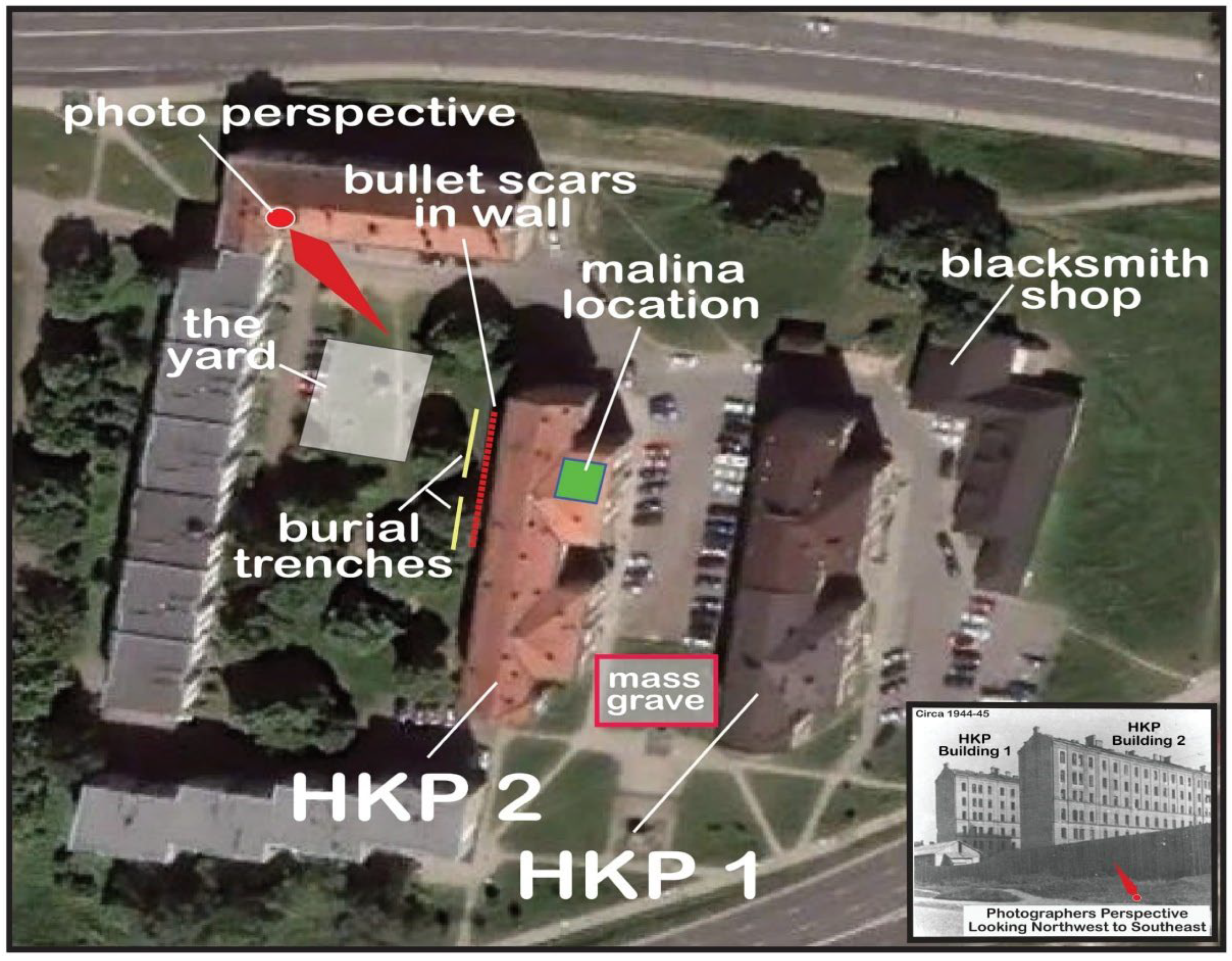
The story of Oskar Schindler and his protection of nearly 1100 Jews who worked in his factory in Poland is well-known and provides another example of human triumph in the face of tragedy [26,27]. A somewhat similar story to that of Schindler, but lesser known, is the story of Karl Plagge [6,7,11] and Heereskraftfahrpark (HKP) 562. Plagge differed from Schindler in that he was a military man, a major in the German Wehrmacht Engineering Unit, where he was in command of HKP 562. Although the SS officially administered this unit, Major Plagge ran its day-to-day operation. Plagge was sympathetic to the plight of his Jewish workers, and he and some of his men tried to protect Jews from the murderous intent of the SS. As already established, he provided work certificates to Jewish men in the ghetto, certifying them as essential and skilled workers regardless of their backgrounds. This work permit protected the workers, their wives, and two of their children from the SS. In September 1943, when Plagge heard of plans to liquidate the Vilnius Ghetto, he moved approximately 350 men, their wives, and two children (for a total of about 1000 people) to HKP Camp 562. Plagge created HKP 562 on the outskirts of Vilnius (see Figure 1) at two already-existing six-story housing blocks from the early 1900s (Figure 3). The workers and their families lived at HKP in relative safety under the protection of Major Plagge [6,28].
On 27 March 1944, while Major Plagge was in Germany visiting his family, as many as 200 children were rounded up at HKP 562 by the SS and murdered in the Ponary Forest as part of a Kinder Aktion (action against the children). On 1 July 1944, Major Plagge was back in the camp, and he addressed the prisoners to inform them that the SS was to arrive on July 3 to relocate them to a new work camp. Many of the Jews took this to mean that they would be killed (liquidated) on that day, and about half went into prepared hiding places they called “malinas” (named for a slang word in use at that time meaning a place where criminals hide from authorities) [29]. On 3 July, the SS called for all camp residents to appear for a roll call. The approximately 500 persons that did were immediately transported to the Ponary Forest, shot, and buried. A search over the next three days found about 200 Jews in hiding. They were shot and hastily buried in mass-burial trenches on-site. The SS then fled as the Red Army approached. Upon their arrival, the Jews still hiding in their malinas emerged and soon realized that all other camp residents were gone, or they lay rotting in shallow trenches at HKP. Over the next several days, the remaining Jews removed the bodies from the trenches and reburied them in one mass grave somewhere on the HKP site [6,7,8].
The existing knowledge about HKP 562 comes from Jewish survivors and testimony and evidence from the 1947 war crimes trial of Karl Plagge [30]. Jewish survivors from HKP testified on behalf of Major Plagge at his trial. Upon its conclusion, he was allowed to return to his hometown of Darmstadt, Germany, to live out his remaining days (he died in 1957). After the war, details about the HKP 562 Camp became hazy memories, and—like thousands of other sites of importance in the Holocaust—these memories faded with time.
2. Materials and Methodology
In the summer of 2017, equipped with Ground-Penetrating Radar (GPR) and Electrical Resistivity Tomography (ERT) instrumentation, a drone, and a Global Positioning System (GPS) and Total Station land surveying system, data were collected in and around the site of HKP Camp 562 [13,14,15,16,17]. The objectives of this project’s research design were to: (1) locate the site of an entrance into the largest malina; (2) determine the location of the original burial trench(es) for the Jewish prisoners found in hiding and murdered by the SS; (3) find the precise location of the mass-burial site were Jewish survivors reburied the remains from the trench(es); and (4) locate any other evidence related to the murder of Jews at the HKP 562 site. Meeting these objectives will contribute significantly to understanding what transpired at the site and can serve as a model for other endeavors to uncover the hidden history of the Holocaust and genocide at thousands of other never or poorly studied sites worldwide.
This research used the following methods on-site at HKP.
2.1. Gridding
All local grid maps for this project were georeferenced to the datum of WGS84, Zone 35N (EPSG:32635) for Lithuania. In addition, Topcon Total Station and Trimble Geo7 GPS data were georeferenced to the datum of WGS84, UTM Zone 35N. High-resolution (2 cm/pixel) Mavic Pro or M100 UAV orthophotos from drone surveys and Google Earth images served as georeferenced backdrops for some project base maps.
2.2. Ground-Penetrating Radar (GPR)
GPR is a shallow, non-invasive, subsurface investigation technique capable of mapping interfaces in a cross-sectional format. GPR measures the propagation time of high-frequency electromagnetic pulses reflected from interfaces between materials of different electrical properties. Radar reflections can occur with abrupt changes in moisture content, grain size, porosity, or soil texture. Reflections can also result from the disturbance of the soil structure caused by digging pits or ditches, and in an archaeological context from energy scattering off discrete objects such as large pieces of pottery or lithic artifacts, or internal reflections within void spaces or large pots.
This survey utilized a hand-towed 500 MHz antenna system (Figure 4). In the typically sandy soils in Vilnius, with a radar velocity of 0.10 m/nanosecond (m/ns), 500 MHz antennas have a wavelength of about 12 cm. As such, they can use imaging features of size on the order of 0.12 m but can detect objects on the order of size of a quarter wavelength, or 0.03 m. Generally, GPR data traces are collected every 0.02 m along lines spaced 0.25 m apart. First, the digital profiles were downloaded, saved to an external hard drive, processed, and plotted using pulseEKKO, GFP Edit, and EKKO_Project software packages [30]. Basic processing included automatic gain control (AGC), signal saturation correction, trace stacking (horizontal averaging), and point stacking (running average), as well as other routines when necessary. Next, these very dense vertical two-dimensional data sets (called sections) were gridded into volumes. The three-dimensional volumes were then horizontally “sliced” down in intervals of 0.05 m thickness. Finally, using a velocity of 0.100 m/ns, a time-to-depth conversion was completed.
2.3. Electrical Resistivity Tomography (ERT) and Induced Polarization (IP) Cross-Sectional Imaging
ERT is a technique for mapping the distribution of subsurface electrical resistivity (or its inverse conductivity) in a cross-sectional format. Resistivity data are collected through a linear array of electrodes coupled to a direct current (DC) resistivity transmitter and receiver, and electronic switching relays. The spacing between electrodes essentially controls the horizontal and vertical resolution of the data (smaller spacing results in higher horizontal and vertical resolution). Similarly, the array’s length controls the investigation depth (more extended arrays yield greater investigation depths). Data collection is sequential and automated, taking advantage of all possible combinations of current injection and potential measurement electrodes. First, downloaded data are processed and analyzed on a laptop computer, often in the field. Then, the data are inverted (i.e., modeled) using a two-dimensional (2D) finite difference or finite element inversion routine using the software package RES2D [31]. The final product is a 2D cross-section (known as a “true” geoelectric section) plotting resistivity (in Ohm-m), or conductivity (in milliSiemens per meters [mS/m]), versus depth.
IP is a second electrical imaging survey collected simultaneously and with the same equipment as the ERT survey. While resistivity surveys image the subsurface in terms of its unit volume resistance to the passage of electrical current, IP images the subsurface in terms of its changeability, which is loosely analogous to the ability of the subsurface to store electrical charge. Resistivity measurements take place while current passes through the subsurface. During IP measurement, no current actively transmits through the subsurface materials. Chargeability, measured in milliseconds (msec), represents the area under the voltage curve that rapidly decays after current transmission ceases. A chargeability section can be inverted (i.e., modeled) from the acquired raw IP data. Generally, sand and silt will have zero chargeability, and clay may have a very low but measurable chargeability of a few msec. Metal objects can have a chargeability of tens, hundreds, or thousands of msec, depending on the size, surface area, and depth of burial.
2.4. Unmanned Aerial Vehicle (UAV) Photogrammetry and Multispectral Aerial Photography
Multispectral imagery and visible light photogrammetry (also called RGB or red, green, blue color model) were collected from a MicaSense Sequoia [32,33] camera mounted on to a DJI Matrice 100 quadcopter UAV [34] (also called a “drone”). The Sequoia records four discrete spectral bands of light (MicaSense 2016), including green, red, Red Edge, and near-infrared (NIR). Conventional photographs are also captured with the RGB visible light imager. A higher-quality visible light camera (a 12.0-megapixel DJI Zenmeuse X3) was also mounted on the Matrice 100 to improve the quality of the photogrammetry.
Reflected energy in the green spectral band (wavelengths of 530 nanometers [nm] to 570 nm) can correlate to leaf chlorophyll content. As such, the green band may provide information where vegetation is stressed due to, for instance, buried pavement or a shallowly buried wall limiting root growth. Or the green band may indicate areas of unusually healthy vegetation due to, for example, the remains of an old garden plot or in the context of this research human burials, which may be capturing more moisture and nutrients. The red spectral band (wavelengths of 640–680 nm) is often strongly absorbed by vegetation. As such, red band energy is used in the vegetation indices (such as Normalized Difference Vegetation Index (NDVI)) to calculate vegetation stress or to contrast vegetation with exposed soil. The Red Edge band (narrow band of wavelengths of 730 nm–740 nm) bridges the spectrum for red to near-infrared reflectance and is particularly sensitive to plant nutrient stress. Near-infrared wavelengths (770 nm–810 nm) are sensitive to vegetation type and stress.
Photogrammetry is the science of creating maps from photographs. The photogrammetry software Pix4D was used to manage all multispectral information. Using data from the Matrice 100 quadcopter flown at approximately 40 m, an orthophoto (i.e., a photographic base map) was created using Pix4D and Agisoft Photo Scan software platforms. These orthophotos have a resolution of about 5 cm/pixel or less. Georeferencing was accomplished with drone-mounted GPS and GPS locating of discrete features on the ground (e.g., the corner of a paved walkway) that appear in the drone image and georeferenced intentionally placed aerial targets.
2.5. Archival and Testimony Research
An understanding of the historical significance of a place such as HKP often comes from written and oral testimony. As with many places where the Nazis perpetrated atrocities, many witnesses were murdered and could not write down or tell their stories [35]. Yad Vashem, the World Holocaust Remembrance Center, contains hundreds of millions of pages of documents, photographs, and video, audio, and written testimonies. It does have a few testimonies from HKP. Included below is a small but very pertinent sample of testimonies related to the liquidation of and survival at HKP. What was said in the testimony greatly influenced where geophysical analysis took place at the site. The linking of this invaluable cultural/historical resource with geoscience techniques predicated discoveries at the HKP site.
Survivor testimonies indicated that the SS murdered Jews found in hiding on-site. See below a testimony from survivor Mosche (Moses) Feigenberg [36]:
“Discovering a large percentage of inmates did not appear at the inspection, the Germans started a search of both buildings, and those discovered there (numbering about 200) were shot immediately in the yard.”
From Esther Bratt’s testimony [37]:
“The Germans also found some hiding places, dug shallow graves in the yard, and shot the people. When families returned (who emerged from hiding), these graves were barely covered.”
2.6. Linking the Testimony to the Research Design
Near the outside wall of Building 2, witnesses reported that prisoners were shot and buried in a long trench [6]. A photograph inserted as part of Figure 3 shows how the HKP site looked at the end of World War II. As seen in the photograph, a wooden fence surrounded the turn of the 20th-century buildings and several outbuildings. As stated in Esther Bratt’s testimony [37], the Nazis shot the Jews found in hiding and buried them near the “yard,” which is on the west side of Building 2. This location is along the visible side of the building in the photograph and just off the right edge from the viewer’s perspective (see Figure 3).
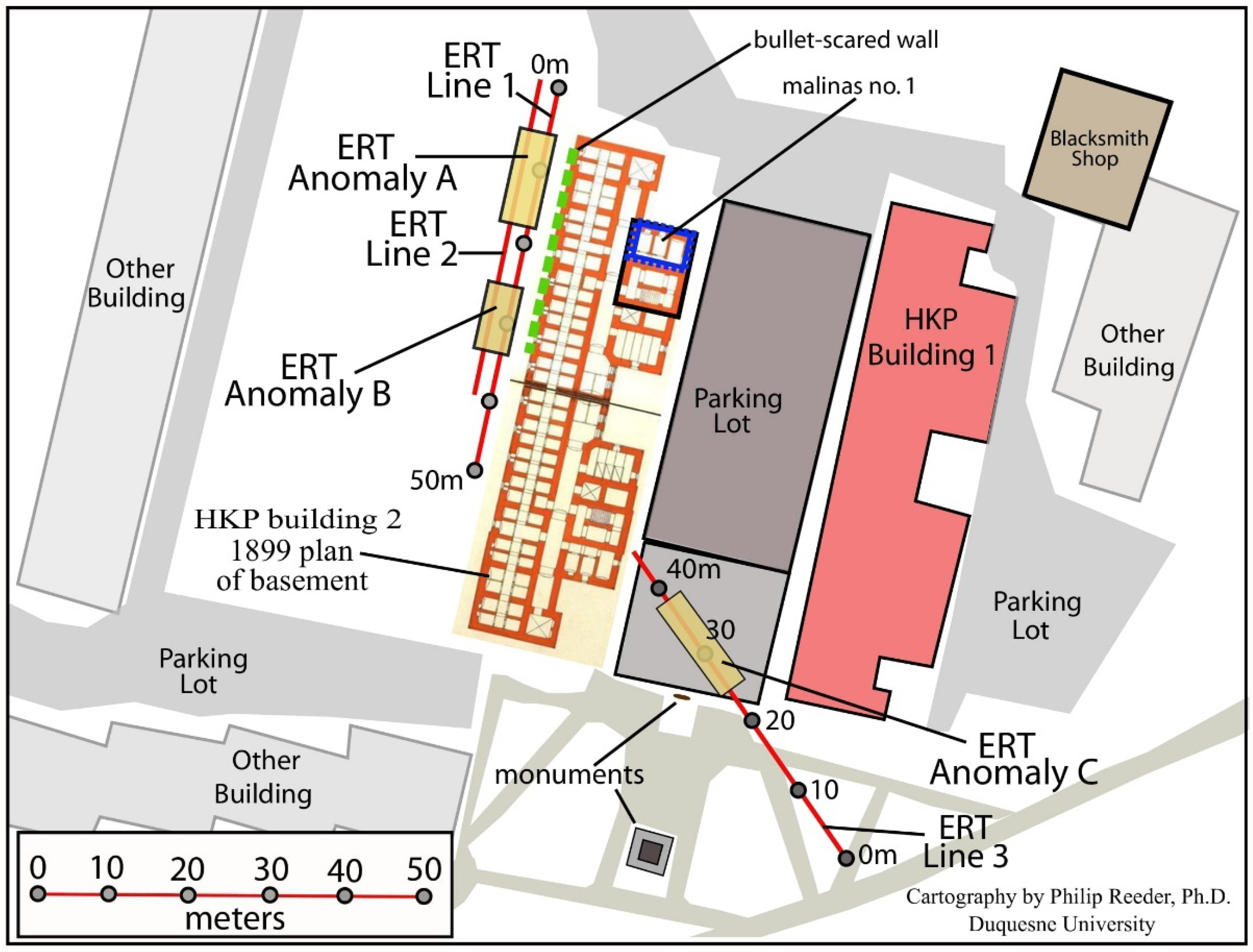
This information also links to the image in Figure 3, which is a visual base map of the site built on information collected in part from a drone and testimony, and plotted on a 2021 Google Earth satellite image. Based in part on Esther Bratt’s testimony [37], 50- and 40-m-long ERT transect lines were placed (Figure 5) along the west side of Building 2, adjacent to the area that the survivors called “the yard.” In addition, Sidney Handler provided personal testimony at HKP in 2017, who, as a ten-year-old in 1944, survived the camp’s liquidation by the Nazis. Upon emerging from his hiding place in the attic of Building 2, he saw a hastily dug grave(s). He could point to this general area in 2017, which further refined the placement of the two ERT transect lines.
2.7. Existing Map, Air Photo, and Satellite Image Review
Historic maps and air photos were accessed online through the Central State Archives of Lithuania [39]. This site, in part, utilizes ESRI’s Storytelling Solutions Software [40], and contains ArcGIS Story Maps [41] for Lithuania. The user can zoom in and “toggle” back and forth between a 2016 country-wide map, and where coverage exists—World War II era air photos. Unfortunately, the site of HKP 562 is not visible in these air photos because of thick cloud cover. Satellite images for multiple years, from 1985 to 2022, were obtained using the online features of Google Earth. Images were compared visually, and overlays were created using Adobe Illustrator software [42].
3. Results
3.1. Photogrammetric Data
Photogrammetric data were collected using a drone, which provided a high-resolution rendering of the study area. Analysis of reflected energy from the multispectral bands collected via the drone in the green spectral band indicated no vegetation stress related to possible buried architectural structures or no areas of unusually healthy vegetation due to, for example, old garden plots or buried bodies. Analysis of the red spectral band also did not indicate any vegetation stress.
3.2. The Burial Trenches
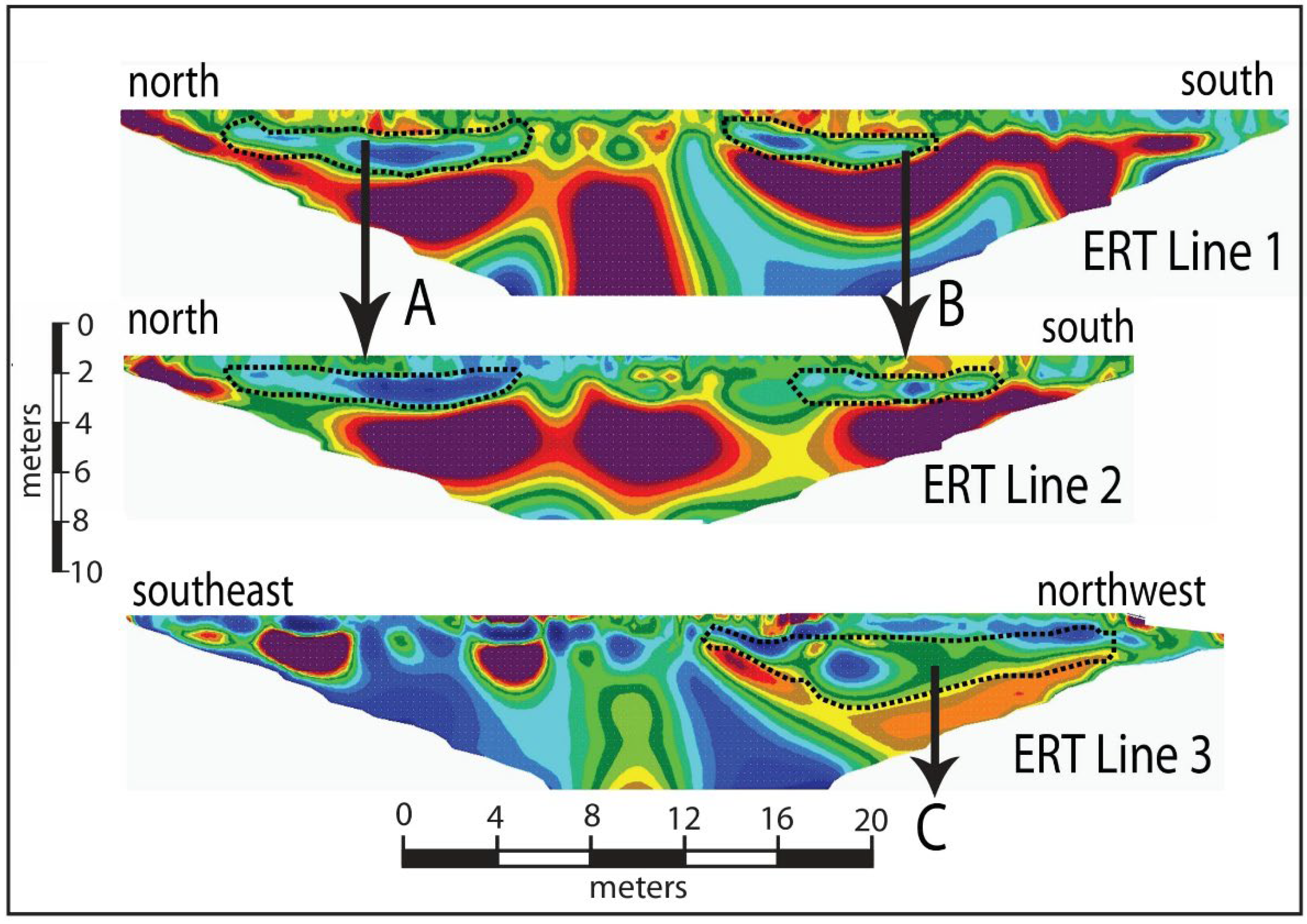
Resistivity anomalies are present along ERT lines 1 and 2 (top two profiles in Figure 6). These anomalies likely indicate variations, from the near-surface down to two meters, in soil compaction, bulk density, porosity, and permeability, compared to surrounding materials [43]. Digging a trench, filling it with bodies, removing the bodies for reburial, and refilling the trench influence these soil properties. The anomalies, correlated with the testimonies and memoirs [36,37,38], indicate that this is the most likely location of the burial trenches. Interpretation of this data shows that resistivity anomalies exist between 6 and 18 m (anomaly A in Figure 6) and 26 and 34 m (anomaly B in Figure 6) along both lines. Hence, there are two separate burial trenches, one 12 m long and the other 8 m long. The trenches are sufficiently wide to be detected in both ERT lines, meaning they are at least three meters wide. No IP anomalies, indicating the presence of metal, were detected in either ERT line.
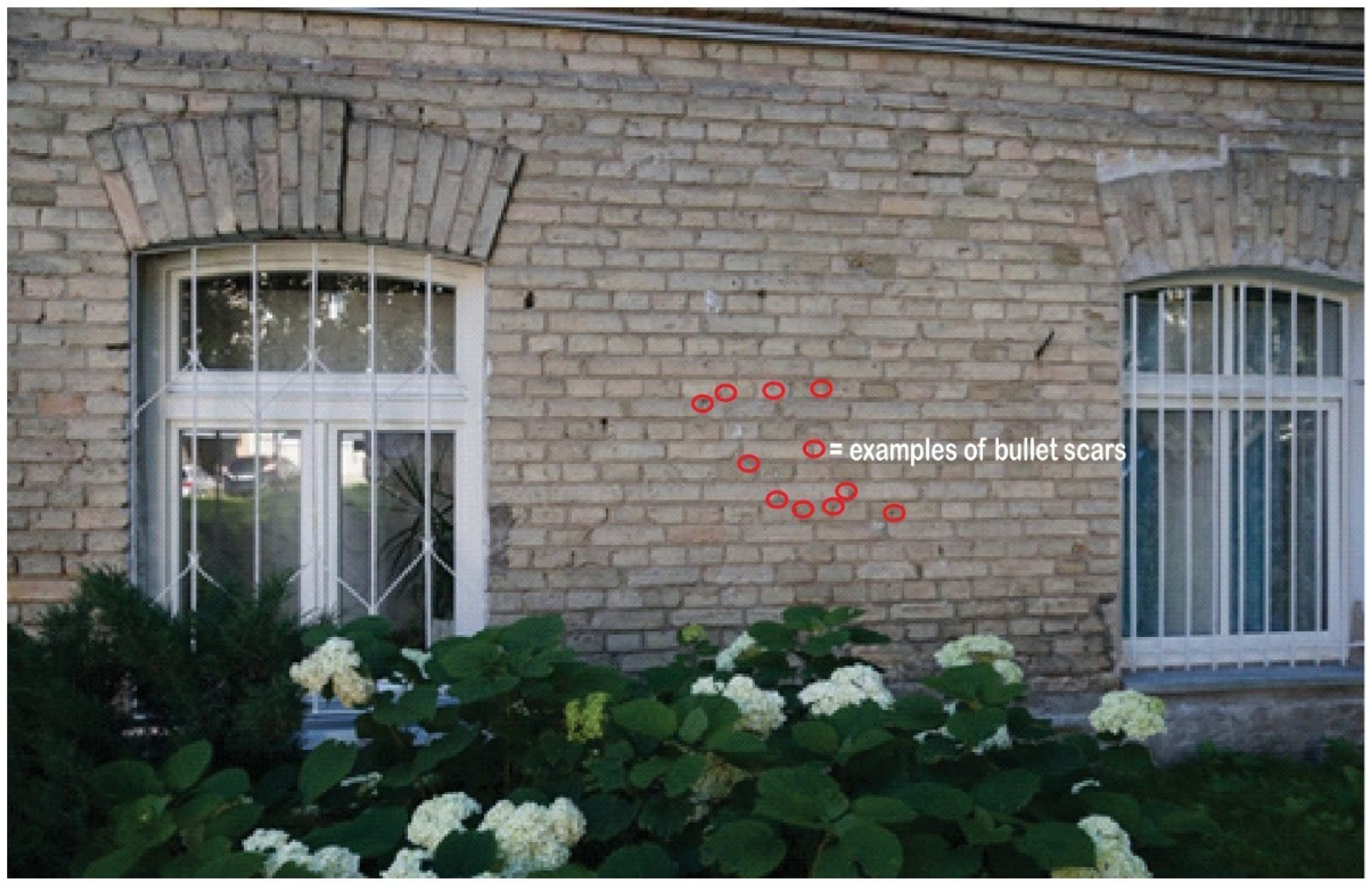
Further fortifying that ERT lines 1 and 2 intersected the burial trenches is the presence of damage caused by bullet impacts to the walls of Building 2. Figure 7 is a photograph taken in 2017 of the ground floor section of the southeast-facing wall of HKP Building 2. Damage from bullet impacts, circled in red, is readily apparent. The bullet-damaged wall sections are <4 m from the burial trenches (see Figure 3), indicating that the victims murdered on-site were shot very near the trenches. These scars in the brick correlate with the upper center mass and head area of the shooting victims.
3.3. Malina Location and Entrance
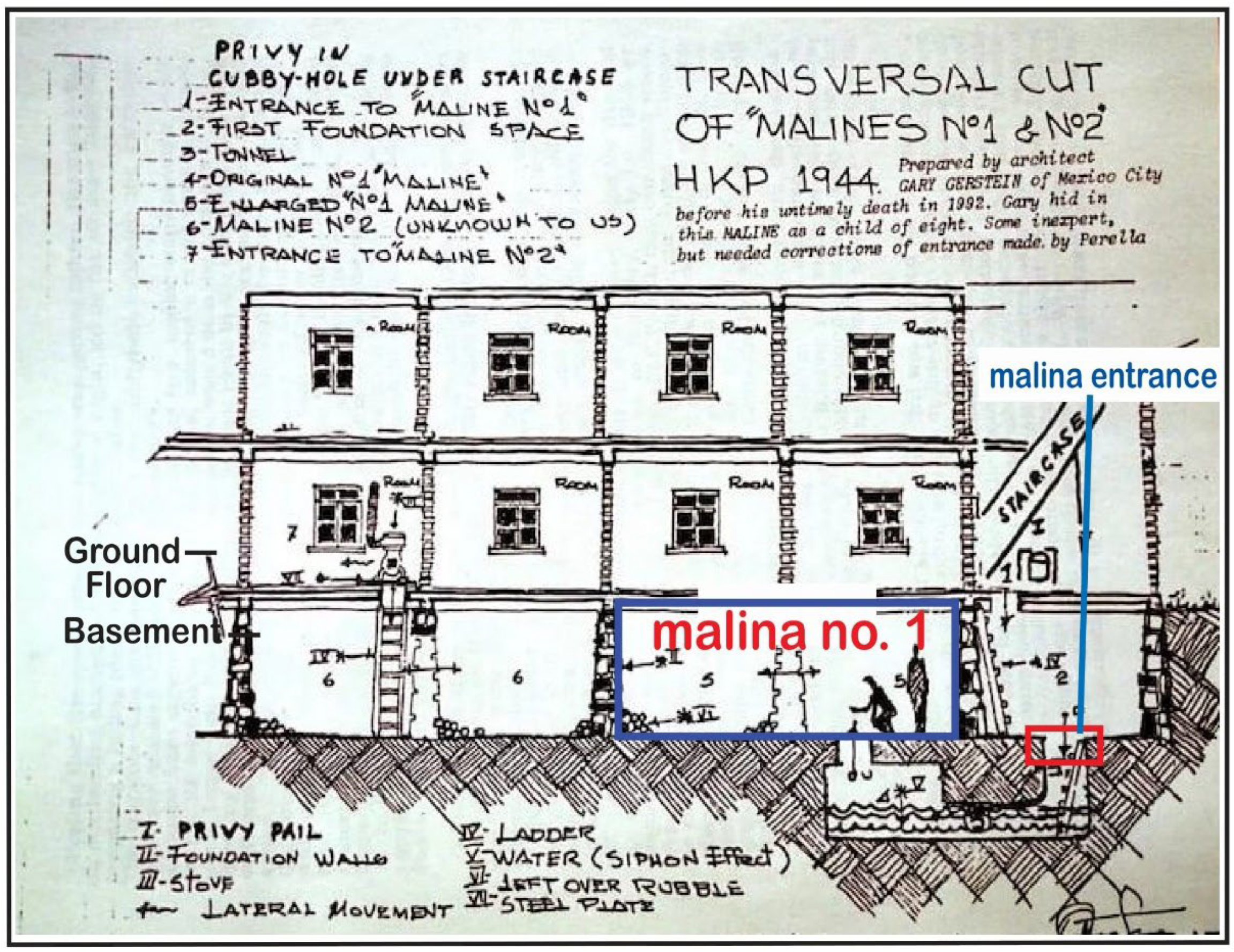
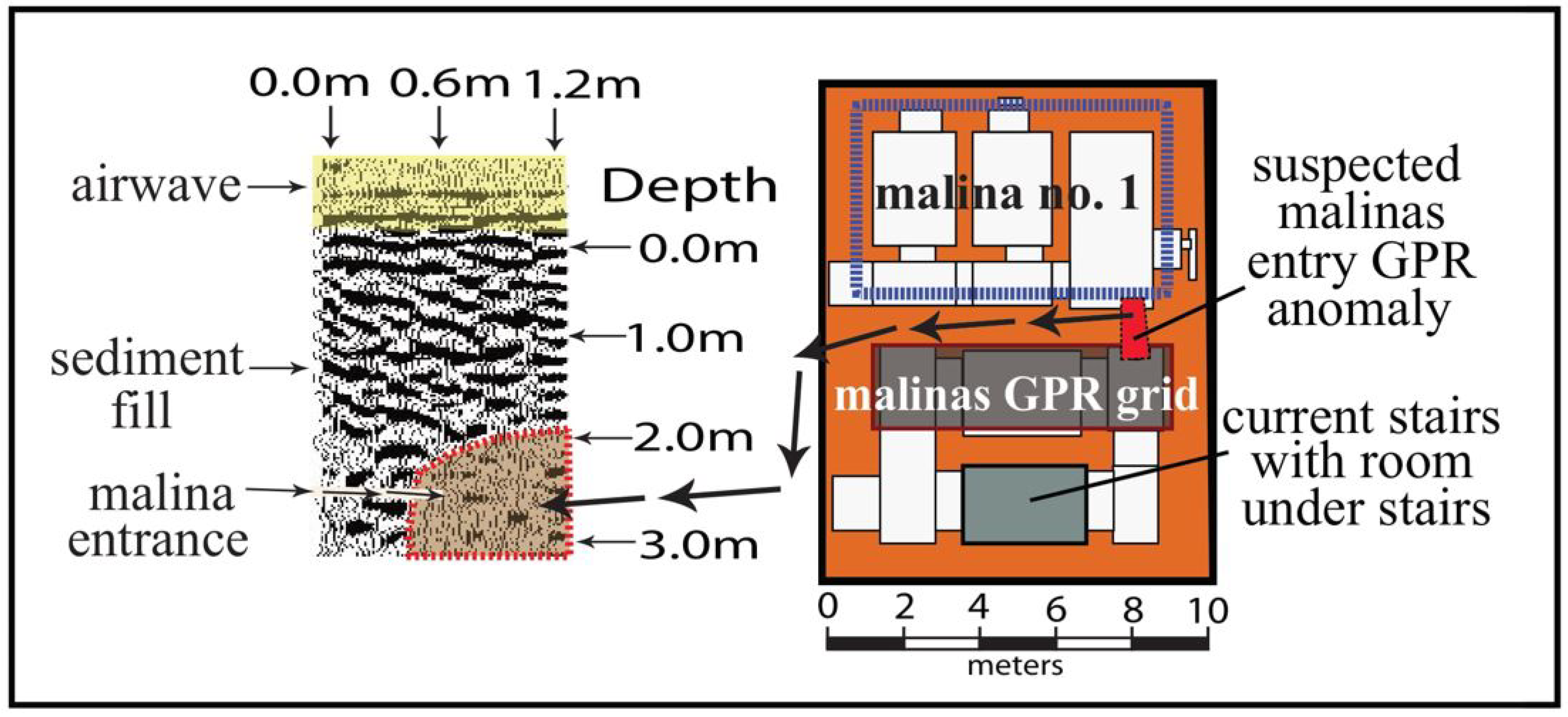
Michael Good’s [6] description, and a drawing by Gary Gerstein, provide the only evidence of the location of the malina. Gerstein, who, as an eight-year-old child, hid from the SS in the malina, created a diagram, as an adult, from memory (Figure 8). His diagram depicts two separate malinas in Building 2, with malina no. 2 accessed by moving a stove in a ground-floor apartment. Attempts to locate malina no. 2, on the viewers left in Gerstein’s drawing, were unsuccessful. To confirm the location of the largest malina (no. 1 from Gerstein’s sketch), a GPR grid was placed in the basement that would logically coincide with the entrance depicted in the drawing. The 1899 architectural plan of the basement, which is little changed today, therefore holds for 1944 as well (right side of Figure 9). In Gerstein’s drawing, the malina no. 1 entrance is at the end of a short hallway at the base of the stairs that connect the ground floor to the basement. Figure 9 shows the GPR grid location, malina entrance, and the cross-section of the GPR data. An anomaly (shaded brown) between 2 and 3 m in the profile is clearly visible. The location of this anomaly correlates with where Gerstein’s plotted the entrance in his diagram.
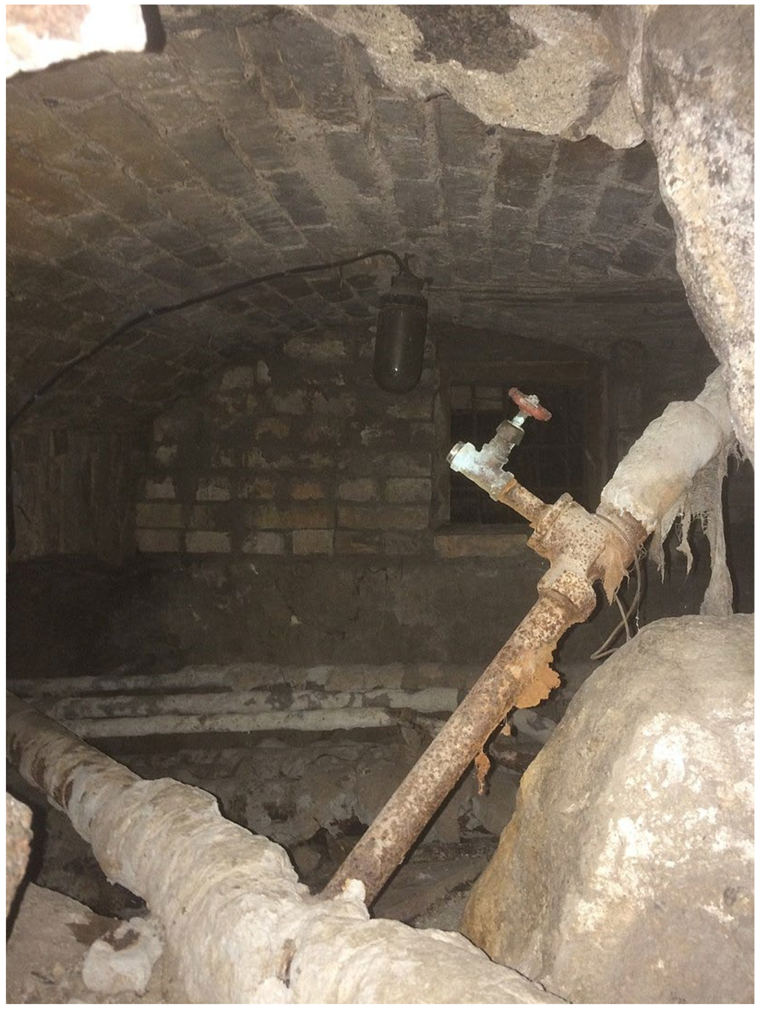
Other features in the vicinity of the GPR grid further corroborate that this is the entrance to malina no. 1. The municipal government, after World War II, installed central steam heating in HKP buildings 1 and 2. Part of this process demolished portions of basement walls, and opened passageways through which the pipes could pass. One such passage was in the vicinity of the malina no. 1 GPR anomaly. A photograph [6] taken from the malina entrance anomaly location (Figure 10), looking through a section of the wall destroyed to allow the steam heat pipes to pass, shows a room that is a portion of malina no. 1.
3.4. The Mass Grave
Based on testimonies and memoirs from survivors [36,37,38], a 45-m-long ERT line was placed in the vicinity of the monuments that memorize the dead [44,45] at HKP to find the precise location of the mass grave (see Figure 3). Monuments are sometimes placed near sites of significance as memorials, with no hard evidence to corroborate that the location is correct [46]. When interpreted, the ERT data collected along line 3 (see the bottom cross-section in Figure 6) indicate an anomaly (anomaly C) that extends from 24 to 38 m along the transect line to depths ranging from 1.0 to 2.5 m below the surface. Similar to ERT lines 1 and 2, ERT line 3 possesses a significant disturbance of the soil, indicative of a hole (trenches in the case of ERT 1 and 2) being excavated and then refilled. Based on survivor testimony [36,37,38] and interpretation of the ERT data, with a high degree of certainty, the mass grave that contains the remains of approximately 200 murdered Jewish prisoners is located between 24 and 38 m along ERT transect line 3 (see Figure 11).
4. Discussion
We often learn history as a coherent string of events leading up to the present moment in perfect bundles [47]. Unfortunately, often this does not hold for the Holocaust because so much is still unknown, and from a humanistic perspective, so much does not make sense. There are thousands of Holocaust sites that remain still undiscovered, are known but not studied, or are poorly studied. Taking an approach that melds geoscience with archaeology has proven viable for uncovering this “hidden” history at HKP.
Research at HKP adds new insights to the knowledge base about this critical—yet little-studied—site. It is a model for how archival and testimony studies, geophysics, mapping, and spatial analysis can work together to study Holocaust and genocide sites. In itself, the drone image, as processed, adds no new information to the existing base of knowledge about what occurred at the site. The expectation was that because the bodies were in the burial trenches for only a few days, there would be no lingering effect of the bodies charging the soils with nutrients, thus enhancing plant growth above the trench. This assertion proved to be correct in the case of the burial trenches. However, because the bodies buried in the mass grave had been there for 73 years, there was a presumed possibility that the drone image would detect reflected energy in the green spectral band, indicating unusually healthy vegetation due to the bodies in the mass grave. Unfortunately, the drone image did not detect this trend. Still, the drone, along with a 2021 Google Earth satellite image, provided a medium for plotting other essential data products (ERT line locations, for example) to establish the spatial relationships between the different data types. Figure 3 shows the spatial relationship between the site of two ERT transect lines, the “yard,” the bullet-scarred wall, the mass grave, the malina location, and a photographic perspective of HKP buildings 1 and 2. Figure 11 further summarizes the location and spatial relationships between these features and serves as the basis for additional discussion.
The place of refuge, malina no. 1 (and its entrance), provided a safe haven for over 100 Jews who survived the camp’s liquidation. A GPR grid was placed in the “most likely” location to encounter the entrance to malina no. 1. using evidence from survivor testimony (Gerstein’s map). Analysis of the GPR data indicated an apparent anomaly at this location. A room associated with the malina, made visible by installing steam pipes in the basement of HKP Building 2, corroborated this fact (see Figure 10). Therefore, all evidence points toward successfully locating the entrance to malina no. 1, and the malina itself.
Along the northwest corner of Building 2, adjacent to the area that survivors of the liquidation called “the yard,” the discovery of bullet-scarred walls and ERT anomalies which indicated two trenches provides direct evidence of the atrocities perpetrated by the SS at HKP. Locating the mass-burial offers direct evidence of these atrocities as well.
The real success of this research is twofold. First, it successfully links data collected using the geophysical techniques GPR and ERT, Global Positioning System (GPS) data, drone imaging, and land surveying with survivor testimony and memoirs, unlocking the hidden and forgotten history of HKP. This information is now part of the historical record, which will live perpetually for this site. Too often, it is easy to mischaracterize Holocaust history that exists in hazy memories of survivors as fact. Data—collected on-site and analyzed by professionals at the top of their fields—bring light to these dim memories and propel them from hearsay to corroborated fact. Secondly, the research design and materials and methodology employed at HKP can serve as the springboard for similar research at thousands of other Holocaust and genocide sites worldwide.
5. Conclusions and Outcomes
The research design for this project put forth four objectives. They were: (1) locate the site of an entrance into the largest malina; (2) determine the location of the original burial trench(es); (3) find the precise location of the mass-burial site where Jewish survivors reburied the remains from the trench(es); and (4) locate any other evidence related to the murder of Jews at the HKP site. Survivor testimony and GPR analysis helped locate the entrance to the largest malina (no. 1). ERT and testimony data helped discover two separate trenches on the west side of Building 2. Given their location, as related to the testimony, and the anomalies’ depth, width, and shape, we feel that these are the initial burial trenches.
Additionally, the ERT data collected in the vicinity of the memorial to the dead at the HKP site indicate a sizable anomaly north of the monuments. Given its location, shape, and depth, we feel that this mass burial contains the bodies from the trenches. Other evidence collected at HKP, such as the bullet-scarred wall on the west side of building 2, further adds to the story of what happened at this place in July 1944.
This research can serve as a model for analysis at other Holocaust and genocide sites. It also more clearly establishes what happened at HKP. As the number of Holocaust survivors continues to decrease and as memories fade, it is essential to add this information to the base of knowledge about this place. Two crumbling apartment buildings that served as housing for the Jews that worked in the camp still occupy the site. Similar to other areas of Vilnius, this area will undoubtedly undergo urban renewal in the coming years. Our work, if nothing else, has written what may be the final chapter of HKP.
Our research team has moved on to conduct similar research at other sites. Since 2017, when we completed research at HKP, we have worked on numerous other projects in Lithuania, Poland, and Latvia. We will continue to uncover this critical and valuable information and tell these “stories” for those that cannot, using geoscience as a tool to write and rewrite the hidden history of the Holocaust.
Author Contributions
Conceptualization, R.F. and P.R.; methodology, P.R., R.F., H.J., A.M., P.B., R.Š.; software, A.M., P.B., H.J.; validation, P.R., R.F.; formal analysis, P.R., H.J., A.M., P.B.; investigation, P.R., R.Š., resources, P.R., R.F., H.J.; data curation, P.R., writing—original draft preparation, P.R., writing—review and editing, P.R., visualization, P.R., H.J., A.M., P.B.; supervision, R.F; project administration, R.F.; funding acquisition, P.R., H.J., R.F. All authors have read and agreed to the published version of the manuscript.
Funding
This research was partly funded by grants from Duquesne University, the University of Wisconsin-Eau Claire, the University of Hartford, the Vilnius Jewish Community, and the Embassy of the United States of America in Vilnius, Lithuania.
Data Availability Statement
Data are available upon request by email to the corresponding author, Philip Reeder.
Acknowledgments
The authors thank the University of Hartford and the University of Wisconsin-Eau Claire students who participated in this research and made its completion possible. Thank you to the Jewish Community of Lithuania and our universities for their support. A special thank you to our co-author Richard Freund, who passed away in July 2022. We spent many years together using geoscience to uncover the hidden history of the Holocaust. Thank you for your knowledge, enthusiasm, energy, and friendship. This research which we worked on together and all we do in the future are dedicated to you.
Conflicts of Interest
The authors declare no conflict of interest.
References
- Barrera, F.B.; Pardo, J.F.J. Geoarchaeology as Geoarchaeology. J. Anthropol. Archaeol. Sci. 2020, 2, 319–321. [Google Scholar]
- Holliday, V.T. Quaternary Geoscience in Archaeology. In Earth Sciences and Archaeology; Kluwer Academic/Plenum: London, UK, 2001. [Google Scholar]
- Sturdy-Colls, C. Uncovering a Painful Past: Archaeology and the Holocaust. Conserv. Manag. Archaeol. Sites 2015, 17, 38–55. [Google Scholar] [CrossRef] [Green Version]
- Mirwis, A. Overlooked Reference Tools for Researching the Holocaust. Ref. Libr. 1998, 29, 227–234. [Google Scholar] [CrossRef]
- Horowitz, I.L. Toward a Natural History of Holocaust Studies. Hum. Rights Rev. 2001, 2, 77–87. [Google Scholar] [CrossRef]
- Good, M. The Search for Major Plagge: The Nazi Who Saved Jews, Expanded Edition; Fordham University Press: New York, NY, USA, 2006. [Google Scholar]
- Malkes, S. The Righteous of the Wehrmacht; Academic Studies Press: Boston, MA, USA, 2014. [Google Scholar]
- Guzenberg, I. Jewish Labor Camp HKP: 1943–1944; Vilnius Gaon State Jewish Museum: Vilnius, Lithuania, 2002. [Google Scholar]
- McClymont, A.F.; Bauman, P.D.; Freund, R.A.; Seligman, J.; Jol, H.M.; Reeder, P.; Bensimon, K.; Vengalis, R. Preserving Holocaust History: Geophysical Investigations at the Ponary (Paneriai) Extermination Site. Geophysics 2021, 87, 1–47. [Google Scholar] [CrossRef]
- Seligman, J.; Bauman, P.; Freund, R.; Jol, H.; McClymont, A.; Reeder, P. Mapping Ponar (Paneriai): A Reassessment. Hum. Remain. Violence Interdiscip. J. 2020, 6, 15–39. [Google Scholar] [CrossRef]
- Viefhaus, M. Zivilcourage in der Zeit des Holocaust. Karl Plagge aus Darmstadt, ein Gerechter unter den Völkern; Darmstädter Geschichtswerkstatt e.V: Darmstadt, Germany, 2005. [Google Scholar]
- Freund, R.A. The Archaeology of the Holocaust: Vilna, Rhodes, and Escape Tunnels; Rowman and Littlefield: Lanham, MD, USA, 2019. [Google Scholar]
- Sturdy-Colls, C. Holocaust Archaeology: Archaeological Approaches to Landscapes of Nazi Genocide and Persecution. J. Confl. Archaeol. 2012, 7, 70–104. [Google Scholar] [CrossRef]
- Eppelbaum, L.V. Archaeological Geophysics. In Geophysical Potential Fields; Elsevier: Amsterdam, The Netherlands, 2019. [Google Scholar]
- Ehrenreich, R.M. Holocaust Archaeologies: Approaches and Future Directions. Holocaust Genocide Stud. 2015, 29, 481–483. [Google Scholar] [CrossRef]
- Cole, T. Holocaust Archaeologies: Approaches and Future Directions. Holocaust Stud. 2016, 22, 454–456. [Google Scholar] [CrossRef]
- González-Ruibal, A. Holocaust Archaeologies. Approaches and Future Directions. Int. J. Herit. Stud. 2016, 22, 859–860. [Google Scholar] [CrossRef]
- O’Neill, A. Number of Victims of the Holocaust and Nazi Persecution 1933–1945, by Background. 2022. Available online: https://www.statista.com/statistics/1071011/holocaust-nazi-persecution-victims-wwii/ (accessed on 15 November 2022).
- History on the Net. Nazi Germany—SchutzStaffel SS. 2022. Available online: https://www.historyonthenet.com/nazi-germany-schutzstaffel-ss (accessed on 15 November 2022).
- Tenenbaum, J. The Einsatzgruppen. Jew. Soc. Stud. 1955, 17, 43–64. [Google Scholar]
- Weeks, T.R. The Operation Reinhard Death Camps: Belzec, Sobibor, Treblinka. Pol. Rev. 2020, 65, 80–82. [Google Scholar] [CrossRef]
- Arad, Y. The Operation Reinhard Death Camps, Revised and Expanded Edition: Belzec, Sobibor, Treblinka; Indiana University Press: Bloomington, IN, USA, 2018. [Google Scholar]
- Friedman, I.R. The Other Victims of the Nazis. 2022. Available online: https://www.socialstudies.org/sites/default/files/publications/se/5906/590606.html (accessed on 18 November 2022).
- United States Holocaust Museum. Holocaust Encyclopedia: Lithuania. 2022. Available online: https://encyclopedia.ushmm.org/content/en/article/lithuania (accessed on 30 October 2022).
- Yad Vashem. The Jerusalem of Lithuania: The Story of the Jewish Community of Vina. 2022. Available online: https://www.yadvashem.org/yv/en/exhibitions/vilna/during/ponary.asp (accessed on 19 November 2022).
- Krammer, A. Oskar Schindler: The Untold Account of His Life, Wartime Activities, and the True Story Behind. Cent. Eur. Hist. 2006, 39, 523–525. [Google Scholar] [CrossRef]
- Jackson, M. Oskar Schindler and Moral Theory. J. Appl. Philos. 1988, 5, 175–182. [Google Scholar] [CrossRef]
- Schoeps, K.H. Holocaust and Resistance in Vilnius: Rescuers in Wehrmacht Uniforms. Ger. Stud. Rev. 2008, 31, 489–512. [Google Scholar]
- Yad Vashem. “Malinas”—The Jews of Vilna in Hiding. 2002. Available online: https://www.yadvashem.org/education/educational-materials/lesson-plans/malinas.html (accessed on 19 November 2022).
- Sensors & Software pulseEKKO Pro Manuals. 2022. Available online: https://www.manualslib.com/manual/1531958/Sensors-And-Software-Pulseekko.html#product-pulseEKKO%20Pro (accessed on 23 December 2022).
- RES2D Manual. 2017. Available online: https://fdocument.org/document/res2dinv-manual.html?page=1 (accessed on 23 December 2022).
- User Guide for MicaSense Sensors. 2022. Available online: https://support.micasense.com/hc/en-us/articles/360039671254-User-Guide-for-MicaSense-Sensors (accessed on 23 December 2022).
- Parrot Sequoia User Manual. 2022. Available online: https://www.manualslib.com/manual/1321911/Parrot-Sequoia.html (accessed on 23 December 2022).
- DJI Matrice 100 User Manual. 2016. Available online: https://dl.djicdn.com/downloads/m100/M100_User_Manual_EN.pdf (accessed on 23 December 2022).
- Maimon, D. Unraveling the Mystery of Major Karl Plagge a Nazi Officer Who Saved Jews. 2022. Available online: https://yated.com/unraveling-the-mystery-of-major-karl-plagge-a-nazi-officer-who-saved-jews/ (accessed on 23 December 2022).
- Holocaust Education & Archive Research Team. The Testimony of Mosche (Moses) Feigenberg: Testimony 2. 2011. Available online: http://www.holocaustresearchproject.org/trials/feigenberg.html (accessed on 17 November 2022).
- McGuire, M. Esther Bratt’s Story of Survival. 2022. Available online: https://sites.psu.edu/localhistories/jewish-community/esther-bratts-story-of-survival/ (accessed on 17 November 2022).
- Test Archive.RU. Life Story of Perella Esterowicz—Pearl Good. 2022. Available online: https://textarchive.ru/c-1882789-pall.html (accessed on 19 November 2022).
- Central State Archive of Lithuania. Antrojo pasaulinio karo metų aerofotonuotraukos. 2022. Available online: https://lcva.maps.arcgis.com/home/index.html (accessed on 18 November 2022).
- ESRI, Storytelling Solutions. 2022. Available online: https://www.esri.com/en-us/arcgis/storytelling-solutions (accessed on 23 December 2022).
- ESRI, ArcGIS Story Maps. 2022. Available online: https://storymaps.arcgis.com/ (accessed on 23 December 2022).
- Adobe, Adobe Illustrator. 2022. Available online: https://www.adobe.com/products/illustrator.html (accessed on 23 December 2022).
- Sadeghi, M.; Babaeian, E.; Arthur, E.; Jones, S.B.; Tuller, M. Soil Physical Properties and Processes. In Handbook of Environmental Engineering; John Wiley & Sons, Inc.: New York, NY, USA, 2018. [Google Scholar]
- Charlesworth, A.; Addis, M. Memorialization and the Ecological Landscapes of Holocaust Sites: The cases of Plaszow and Auschwitz-Birkenau. Landsc. Res. 2002, 27, 229–251. [Google Scholar] [CrossRef] [Green Version]
- Dorot, R. Monuments, Memorial Sites, and Commemoration Sites, Recount History. Int. J. Soc. Sci. Hum. Res. 2022, 5, 364–375. [Google Scholar] [CrossRef]
- Alderman, D.H.; Brasher, J.; Dwyer, O.J. Memorials and Monuments. In International Encyclopedia of Human Geography; Elsevier: Amsterdam, The Netherlands, 2020. [Google Scholar]
- Capstick, L.; Tedx Mile High. Hidden History: Three People Who Rose in the Past. 2022. Available online: https://www.tedxmilehigh.com/hidden-history/ (accessed on 18 November 2022).
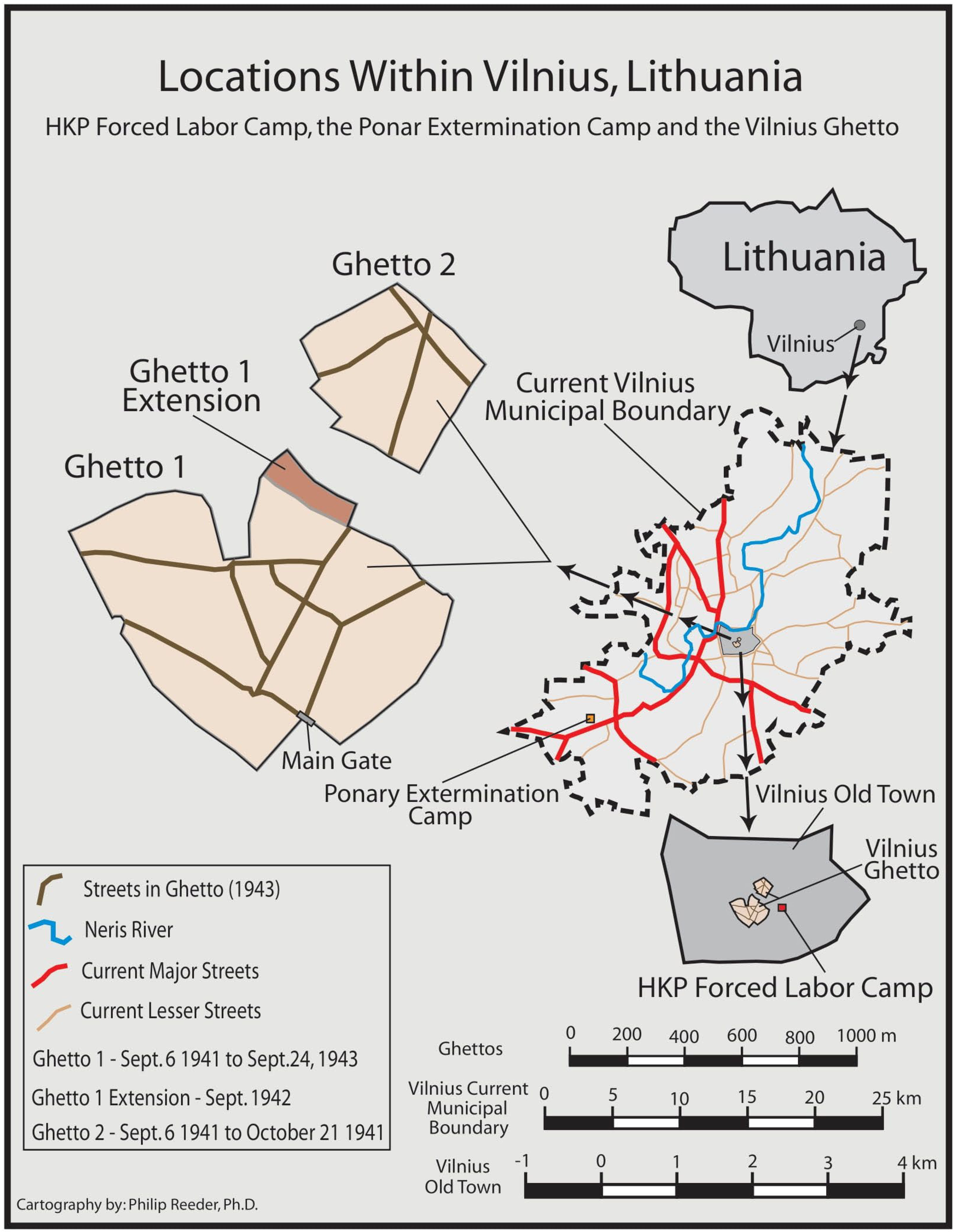
Figure 1.
The location of Vilnius within Lithuania and maps depicting the Vilnius city limits, the area of the old city, the Vilnius Ghetto, the HKP Forced-Labor Camp, and the Ponary (Forest) extermination Camp.
Figure 1.
The location of Vilnius within Lithuania and maps depicting the Vilnius city limits, the area of the old city, the Vilnius Ghetto, the HKP Forced-Labor Camp, and the Ponary (Forest) extermination Camp.

Figure 2.
Map of the Ponary (Forest) Extermination Site 12 km southwest of the HKP Camp, showing the location of 6 memorialized burial pits, 12 ERT transect lines, a previously unknown potential burial pit discovered in 2016, and the inferred location of an escape tunnel discovered using ERT.
Figure 2.
Map of the Ponary (Forest) Extermination Site 12 km southwest of the HKP Camp, showing the location of 6 memorialized burial pits, 12 ERT transect lines, a previously unknown potential burial pit discovered in 2016, and the inferred location of an escape tunnel discovered using ERT.

Figure 3.
Circa 1944 photograph of the HKP housing buildings (lower left), and a 2021 satellite image with the important locations discussed in this article highlighted.
Figure 3.
Circa 1944 photograph of the HKP housing buildings (lower left), and a 2021 satellite image with the important locations discussed in this article highlighted.

Figure 4.
Collecting GPR data between HKP Building 1 and 2, near the memorial to the dead monument.

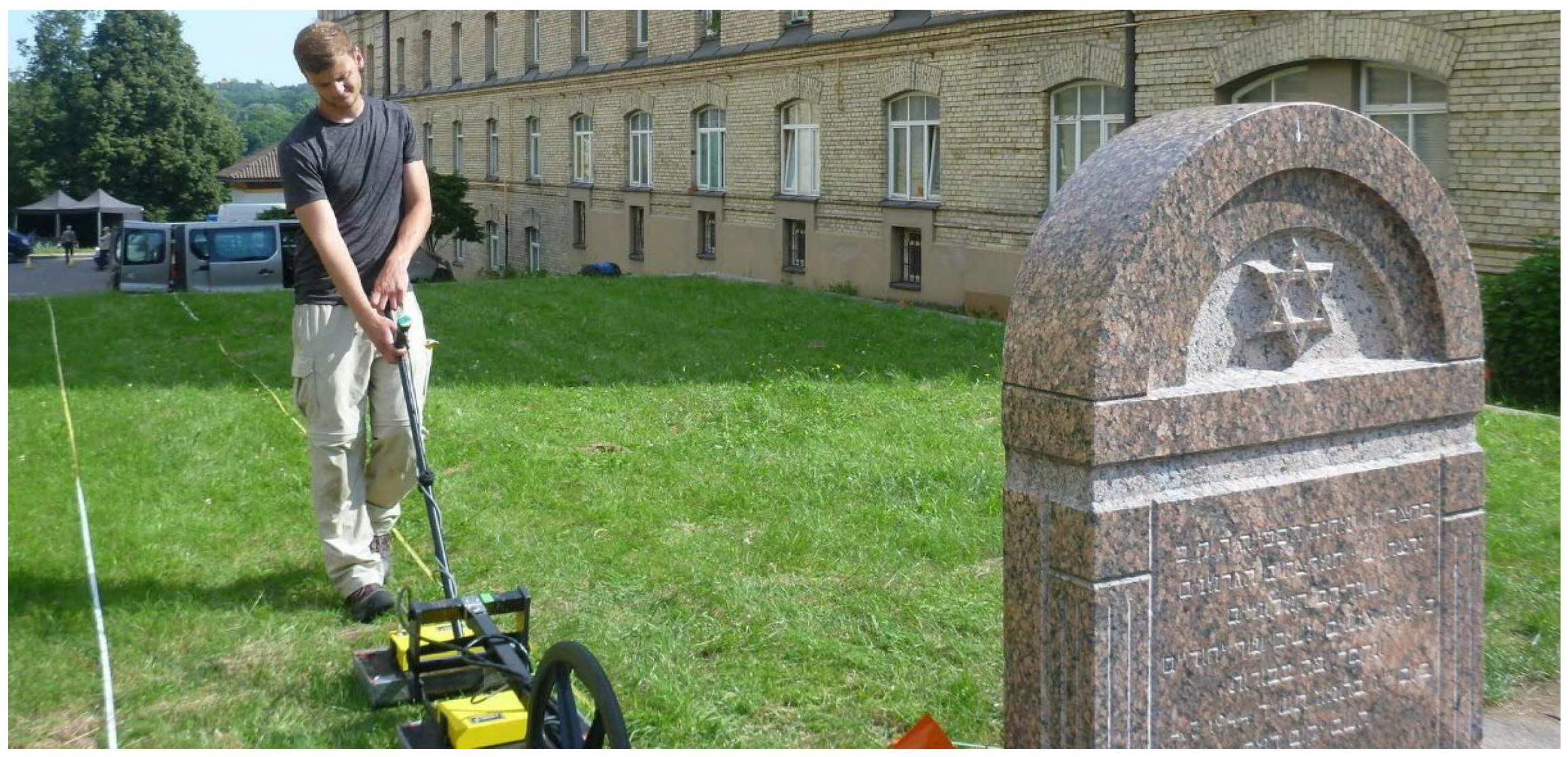
Figure 5.
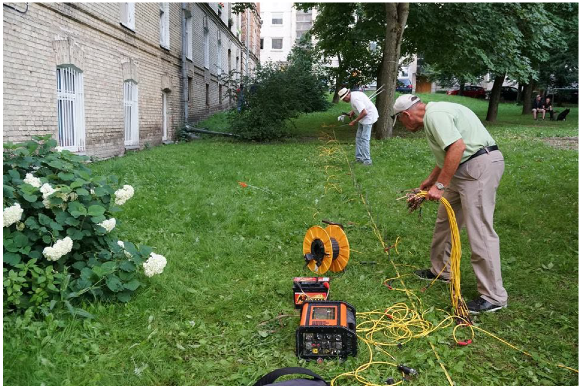
Laying out ERT line 1 on the west side of HKP Building 2.

Figure 6.
Cross-section of ERT line 1, 2, and 3 data.

Figure 7.
West wall of HKP Building 2, with bullet impact scars, indicated.

Figure 8.
Side view of Malinas 1 and 2, as drawn from memory by Gary Gerstein.

Figure 9.
GPR grid location, schematic of malina no. 1 location and entrance, and GPR data plot of entrance survey.
Figure 9.
GPR grid location, schematic of malina no. 1 location and entrance, and GPR data plot of entrance survey.

Figure 10.
Opening created in the basement of HKP building exposed a portion of malina no. 1.

Figure 11.
Map of the HKP Camp with data related to ERT lines 1 and 2; ERT line 3; and the bullet-scarred wall location delineated.
Figure 11.
Map of the HKP Camp with data related to ERT lines 1 and 2; ERT line 3; and the bullet-scarred wall location delineated.

Disclaimer/Publisher’s Note: The statements, opinions and data contained in all publications are solely those of the individual author(s) and contributor(s) and not of MDPI and/or the editor(s). MDPI and/or the editor(s) disclaim responsibility for any injury to people or property resulting from any ideas, methods, instructions or products referred to in the content. |
© 2023 by the authors. Licensee MDPI, Basel, Switzerland. This article is an open access article distributed under the terms and conditions of the Creative Commons Attribution (CC BY) license (https://creativecommons.org/licenses/by/4.0/).
Share and Cite
MDPI and ACS Style
Reeder, P.; Jol, H.; Freund, R.; McClymont, A.; Bauman, P.; Šmigelskas, R. Investigations at the Heereskraftfahrpark (HKP) 562 Forced-Labor Camp in Vilnius, Lithuania. Heritage 2023, 6, 466-482. https://doi.org/10.3390/heritage6010024
AMA Style
Reeder P, Jol H, Freund R, McClymont A, Bauman P, Šmigelskas R. Investigations at the Heereskraftfahrpark (HKP) 562 Forced-Labor Camp in Vilnius, Lithuania. Heritage. 2023; 6(1):466-482. https://doi.org/10.3390/heritage6010024
Chicago/Turabian StyleReeder, Philip, Harry Jol, Richard Freund, Alastair McClymont, Paul Bauman, and Ramūnas Šmigelskas. 2023. "Investigations at the Heereskraftfahrpark (HKP) 562 Forced-Labor Camp in Vilnius, Lithuania" Heritage 6, no. 1: 466-482. https://doi.org/10.3390/heritage6010024