
Inverted Landforms of the Western Caucasus: Implications for Geoheritage, Geotourism, and Geobranding


1
K.G. Razumovsky Moscow State University of Technologies and Management (the First Cossack University), Zemlyanoy Val Street 73, Moscow 109004, Russia
2
Department of Organization and Technologies of Service Activities, Higher School of Business, Southern Federal University, 23-ja Linija Street 43, Rostov-on-Don 344019, Russia
3
Department of Physical Geography, Ecology, and Nature Protection, Institute of Earth Sciences, Southern Federal University, Zorge Street 40, Rostov-on-Don 344090, Russia
4
Department of Commodity Science and Expertise, Plekhanov Russian University of Economics, Stremyanny Lane 36, Moscow 117997, Russia
*
Author to whom correspondence should be addressed.
Heritage 2022, 5(3), 2315-2331; https://doi.org/10.3390/heritage5030121
Submission received: 7 August 2022
/
Revised: 18 August 2022
/
Accepted: 22 August 2022
/
Published: 24 August 2022
(This article belongs to the Section Geoheritage and Geo-Conservation)
Abstract
:Relief inversion is the result of an unusual interplay between landform evolution and peculiarities of geological settings. Recent fieldwork in Mountainous Adygeya in the western part of the Greater Caucasus mountains has enabled the identification of several inverted landforms. The Gud and Gudok mountains constitute a “classical” inverted landform with the top corresponding to the syncline’s core, which consists of relatively hard Middle Jurassic crinoid limestones. The Kabanya mountain, with the nearby branch of the Skalisty range, has a similar geological setting, although the hard Upper Jurassic carbonates that form the monocline and overlie the syncline also contribute to the preservation of the topographical high above the structural low. The northwestern segment of the Skazhenny range is formed of relatively soft Lower–Middle Jurassic shales, and its inversion results from the protection of the syncline’s core by capping Upper Jurassic carbonates. These landforms represent progressive, transitional, and regressive inversion, respectively. Their relative diversity and significance in local topography allow them to be classified as geomorphosites, i.e., important elements of the geoheritage of Mountainous Adygeya. Each of these has certain touristic potential, and a geotouristic route allowing the comprehension of these geomorphosites from several viewpoints is proposed. Climbing these mountains for closer examination may combine geotourism and adventure tourism. Additionally, the Gud and Gudok landform “symbolizing” the geodiversity of the study area can be used for branding local food products such as cheese, which is popular among visitors.
1. Introduction
Inverted relief represents a notable interplay between landform evolution and geology. This phenomenon has been studied for decades [1,2,3], although available knowledge still needs extension and illustration by examples from different parts of the world. Generally, relief inversion occurs via elevation of former topographical or structural lows in which hard substrates and rocks are resistant to erosion—for instance, when a former valley floor becomes a ridge due to massive lava accumulation (topographical inversion) or when a syncline core corresponds to the mountain summit (structural inversion). Examples of inverted landforms have been recorded indifferent parts of the world, including Africa [4,5,6], Central Asia [7], the Middle East [8], and North America [9,10]. Nevertheless, it appears that the true diversity of this phenomenon and its geographical distribution have yet to be realized. Apparently, more attention has been paid by previous researchers to topographical inversion than to structural inversion.
Presently, interest in inverted landforms is facilitated by the growth of geoheritage studies, geoconservation needs, and, particularly, inventories of potentially unique features. Objects with evident geomorphological value are recognized as geomorphosites [11,12,13,14,15,16,17,18,19], although this does not mean any opposition to geosites. In fact, some researchers recognize geomorphological heritage among geoheritage [20], and some argue that any co-occurrence of geological and geomorphological features is an advantage [21]. The uniqueness of many geomorphological features and their conservation value cannot be explained without a geological context. Inverted landforms are representatives of such mutually valuable features [3].
Field investigations in Mountainous Adygeya, which is a geologically and geomorphologically rich area in southwestern Russia (Figure 1) with outstanding geoheritage [20,22], have permitted the documentation of several inverted landforms. On the one hand, certain differences between them allow tracing diverse features of structural inversion in this area. On the other hand, such a local concentration of manifestations of this unusual phenomenon implies that these landforms may contribute to the overall value of the geodiversity hotspot proposed earlier [20].
The objective of the present paper is to characterize the inverted landforms of Mountainous Adygeya, to decipher their origin, and to examine the implications of these features for geoheritage management. The latter includes not only conservation but also exploitation for the purposes of tourism. Our study is based on fieldwork observations, descriptions, and qualitative interpretations. It appeals to the international research community in proposing furthering investigations of both inverted relief and its geoheritage value. Importantly, the present study is not “purely” geomorphological, and it also emphasizes geotouristic interpretations, which is why we include some information that would be typical to tourism-related articles and guides.
2. Geographical and Geological Setting
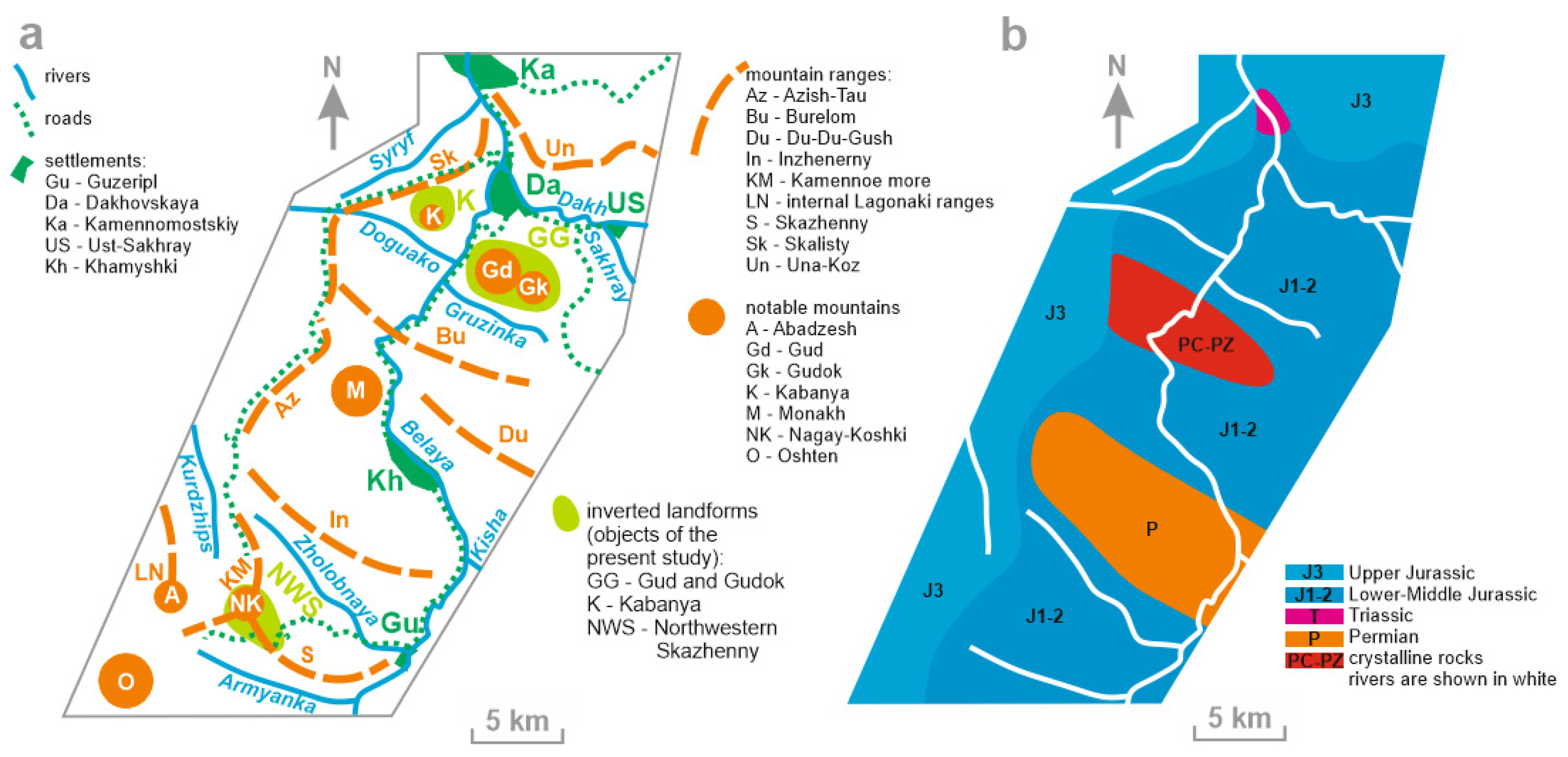
The study area is situated in the Western Caucasus, which is the western segment of the Greater Caucasus mountains. This segment is dominated by elongated, often subparallel mountain ranges, with elevations of 500–2500 m, which separate the Ciscaucasian plains and the Black Sea (Figure 2). The average height of the mountains increases eastwards. Elevations increase gradually on the northern periphery of the Western Caucasus, whereas its southern periphery is characterized by steep slopes.
The geographical characteristics of the study area were published by Bedanokov et al. [23] and Ruban [24]. It is situated within the highest part of the Western Caucasus, where several ranges form an ‘orographic puzzle’ (Figure 3a), differing both in height and shape. Principally, two levels of landforms can be recognized [24]. The upper level includes cuesta-type ranges (sensu [25]), which surround the territory studied in the west and north. These are the Kamennoe more, Azish-Tau, Skalisty, and Una-Koz ranges. Taken together, these ranges can be interpreted as a single, albeit “punctuated” range, with a well-visible, steep scarp exposed to the south and east and a wide, gentle slope dipping to the north and west. The heights often exceed 1000 m and may reach 2000 m. The Kamennoe more and internal Lagonaki ranges form the Lagonaki Highland, which is the highest part of the Western Caucasus, with heights exceeding 2000 m. The lower level of landforms includes smaller ranges (Burelom, Du-Du-Gush, Inzhenerny, and Skazhenny), with elevations of up to 1500 m. These ranges with more or less symmetrical profiles are often joined with cuestas perpendicularly (Figure 3a), and the former are usually lower than the latter, even at junction points. Generally, the local topography looks as if the landforms of the lower level develop only where the “nappe” of the upper level does not exist. Such peculiarities are determined by the geological setting (see below) and the erosional activity of the drainage network of the River Belaya. The climate is temperate, with annual rainfall varying between 500 mm and 700 mm in the north of the study area but increasing to >3000 mm in the south. Valleys of rivers and streams are oriented both subparallel and perpendicular to mountain ranges (Figure 3a).
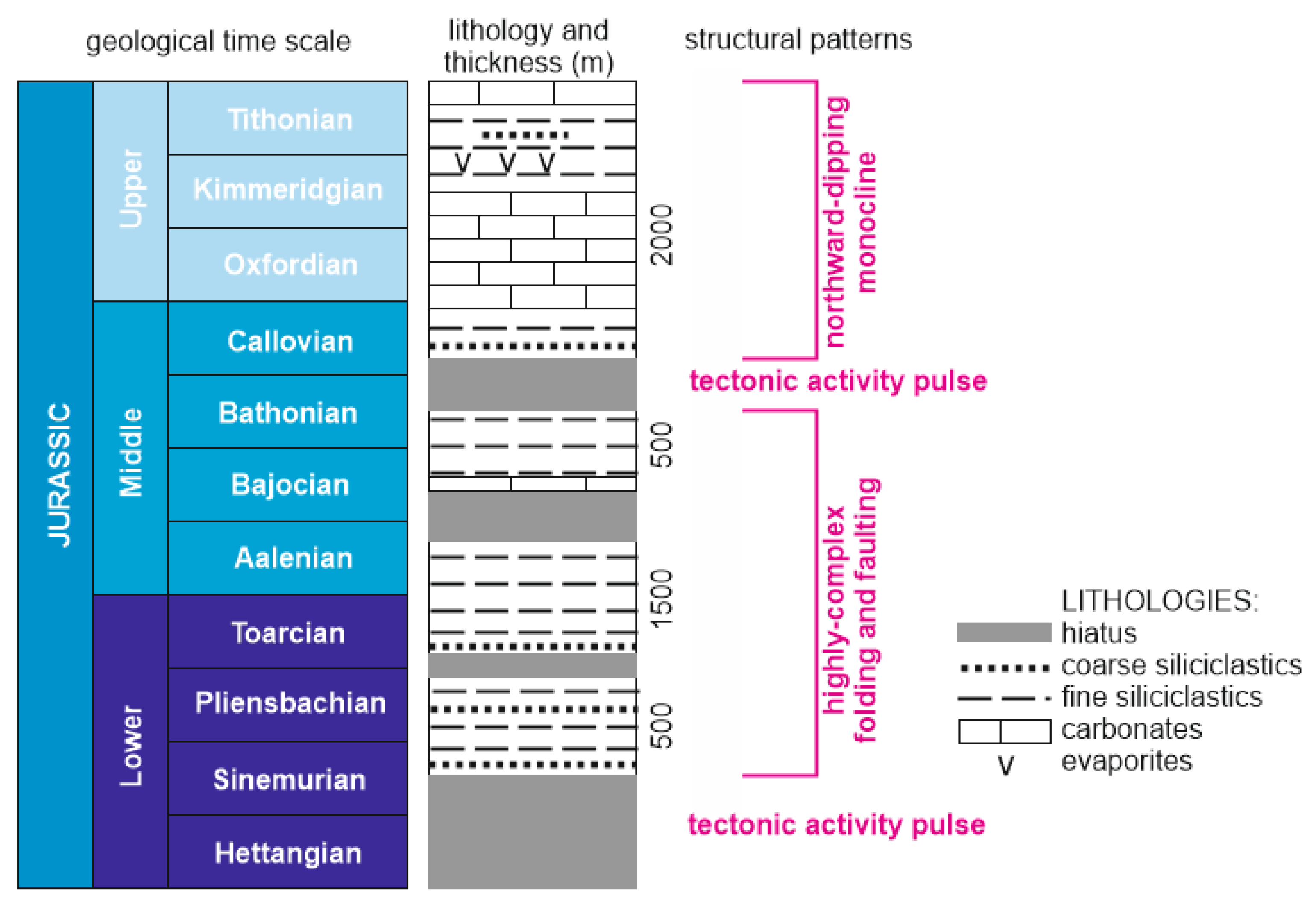
From a geological point of view, the study area (Figure 3b) is part of the late Cenozoic orogen of the Greater Caucasus [26,27,28]. Although some older rocks crop out locally (in uplifted tectonic blocks), it is dominated by Jurassic deposits [29,30], which can be subdivided into two major units (Figure 4). The lower one comprises Sinemurian–Bathonian siliciclastics (chiefly shales, but also sandstones, siltstones, and conglomerates) with rare limestone interbeds and, particularly, Aalenian–Bajocian encrinites [31]. These rocks are strongly folded and faulted. The upper unit includes Callovian–Tithonian deposits of different composition, with a predominance of carbonates (limestones and dolostones) overlain by variegated siltstones. These rocks are less deformed and form a kind of monocline. The entire Jurassic sequence was accumulated in a warm (subtropical to tropical), semi-enclosed, marginal sea (the so-called Caucasian Sea), which corresponded to the back-arc basins on the northern periphery of the Neo-Tethys Ocean [32,33,34,35,36,37,38]. Differences in lithology (“soft” shales overlain by “hard” limestones and dolostones) and deformation style have determined local peculiarities of erosion and the development of topography.
3. Materials and Methods
The information used in the present study has been collected during field campaigns in Mountainous Adygeya. Three inverted landforms have been identified, namely, the Gud and Gudok mountains, which form a single landform with two summits, the Kabanya mountain together with a nearby, tongue-like branch of the Skalisty range, and the northwestern segment of the Skazhenny range near its junction to the Nagay-Koshki mountain (Figure 3). More detailed data have been amassed during climbs onto the inverted landforms and distant observation from several panoramic viewpoints. Attention has been paid to landform morphology, geological setting (including measurements of rock dipping directions and angles), and examination of relationships between erosion-prone and erosion-resistant rocks. Particularly, the presence of capping limestones needed confirmation.
All three inverted landforms are described here, with due attention to their geological setting. Their origin is interpreted on the basis of the data collected. Measurements of rock dipping have proved necessary in order to examine the correspondence of topographical highs to structural lows. Genetic interpretations required looking for very particular features in the field and state-of-the-art interpretations of the lines of evidence gathered. The potential uniqueness of the inverted landforms, i.e., their geoheritage value, was assessed. There are various methodological developments that facilitate the related procedures [39,40,41,42,43]. The basic criteria include rarity (uniqueness sensu stricto), the number of geoheritage types, accessibility, vulnerability, the need for interpretation, and scientific, educational, and touristic importance, as well as aesthetics. Each inverted landform is characterized using these criteria, but without the scoring-based, semi-quantitative assessment that was planned for the other research project. Our understanding of aesthetic properties follows the work by Kirillova et al. [44]. It should be added that the terms “unique” and “uniqueness” are used in a geoconservation sense, i.e., these are linked to the essence of the geoheritage value.
Additionally, the geotouristic potential of all landforms considered was examined. With regard to the importance of climbing for the comprehension of geoheritage [45,46,47], possible routes towards to summits are proposed. The work by Bentivenga et al. [48] and Palladino et al. [49] provides useful examples for developments of this kind.
4. Results
4.1. Gud and Gudok Mountains
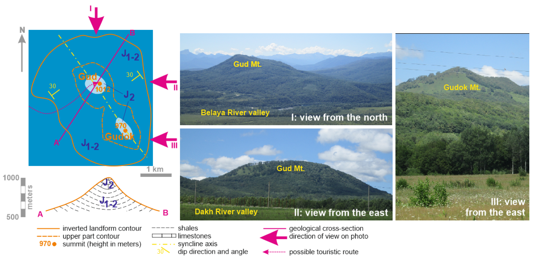
The Gud and Gudok mountains are located in the central part of the study area (Figure 3) and constitute a single landform with two summits, the higher of which slightly exceeds 1000 m (Figure 5). This landform is isolated from the other mountains and ranges of the study area. In the west, north, and east, it is surrounded by wide, flat terraces of the River Belaya and its right tributary, the River Dakh. In the south, it is separated from the Burelom range by a well-shaped, rather narrow valley of a small river, the River Gruzinka, which is another right tributary of the River Belaya. The Gud and Gudok landform has a rather irregular shape (Figure 5); it is elongated, trending from the northwest to the southeast. Its northern and eastern slopes are steeper than those in the south and west. This landform is covered by dense deciduous forests, although meadows are found near its top (especially on the southern slope). Numerous small streams (tributaries of the rivers Belaya, Dakh, Sakhray, and Gruzinka) start from springs on the slopes of this landform and erode it actively.
Geologically, this landform corresponds to a fairly symmetrical syncline, with the axis trending from the northwest to the southeast and a dip angle of ~30° on both flanks. The Gud and Gudok mountains are sculpted by erosion in the Lower–Middle Jurassic dark, laminated, intensively deformed shales. The very top of both mountains is formed by the pink Middle Jurassic crinoid-rich limestones (encrinites), which are younger than the shales and form the core of the syncline (Figure 5). The thickness of these rocks does not exceed a few dozen meters. These rocks are hard enough to be eroded more slowly than the underlying shales. As a result, these capping rocks protect the entire landform from rapid and complete denudation. This seems to be almost a “classical” example of an inverted landform (structural inversion), i.e., a mountain corresponding to a syncline with hard rocks in its core. The encrinites are not solid, but are fractured limestones. Their clasts occur widely on the slopes. Their thickness is rather limited; apparently, they could have been eroded quite rapidly. However, this has not happened, and the most plausible explanation is the absence of linear erosion in the upper part of the slopes. However, linear erosion is present in the median and low parts of the slopes (approximately at elevations <800 m), i.e., below the encrinite exposures. It may be hypothesized that the capping rocks protected the landform from denudation more efficiently, together with the increase in its relative height and steepening of its slopes due to the simultaneous decrease in stream source elevation. If this is correct, the denudation of the landform slowed down throughout its evolution. The Gud and Gudok mountains are identical as far as their setting is concerned, and the existence of a single, elongated mountain, instead of two mountains at present, may be assumed. Their separation by a saddle can be explained by the activity of some streams in the past.
The uniqueness of the Gud and Gudok mountains is determined by the almost “classical” representation of an inverted landform—a particular category of morphostructure. Such a huge and isolated (and, thus, well-visible from all sides) inverted landform seems to be unique on a local scale, at least. The potential uniqueness (sedimentological, palaeontological, and palaeogeographical) is also linked to the Middle Jurassic encrinites, but their representative sections have yet to be documented; these rocks are better known from the nearby Kabanya mountain [31]. If so, this landform can be assigned only to the geomorphological type of geoheritage and, thus, this is a geomorphosite. Site accessibility is excellent because it is visible from the principal roads and the nearby village of Dakhovskaya. However, the site is huge in size, and any excursions within it face serious difficulties (see below). This geomorphosite is not vulnerable to any negative factors. Understanding its nature requires professional interpretation by experts in local geomorphology and geology. Many details of local geology remain unknown (for instance, the exact age and thickness of the encrinites), which holds especially true for the Gudok mountain. Indeed, this site can be used to demonstrate structural inversion to earth science students at several Russian universities that organize their field educational programs here. The touristic potential of this site is linked to the possible interest of geoscience professionals, beginners, and amateurs who wish to “conquer” one of the most notable landmarks of Mountainous Adygeya. Finally, this landform boasts significant aesthetic properties, among which the size, isolated position, and landscape dominance are the main ones.
Climbing the Gud and Gudok mountains is challenging. The slopes are locally gentle, although their angles rise to 45° and more in some places. However, more problematic is the absence of roads and trails leading to the summits, through dense forest and tall grass in meadows. In contrast, the summits are rather flat and comfortable for accommodation. The best approach would be to start any excursion from the point where the principal road crosses the River Gruzinka, to move along its valley (full of large woody debris) for ~1.5 km, to go up along any right tributary, and then to climb directly to the summit (Figure 5). A two-way excursion involves ~10 km and up to 10 h and requires significant training for hiking in wild places with dense vegetation, rather than “pure” climbing skills. The local presence of large-sized wild animals such as boars, wolves, and bears should also be considered.
4.2. Kabanya Mountain
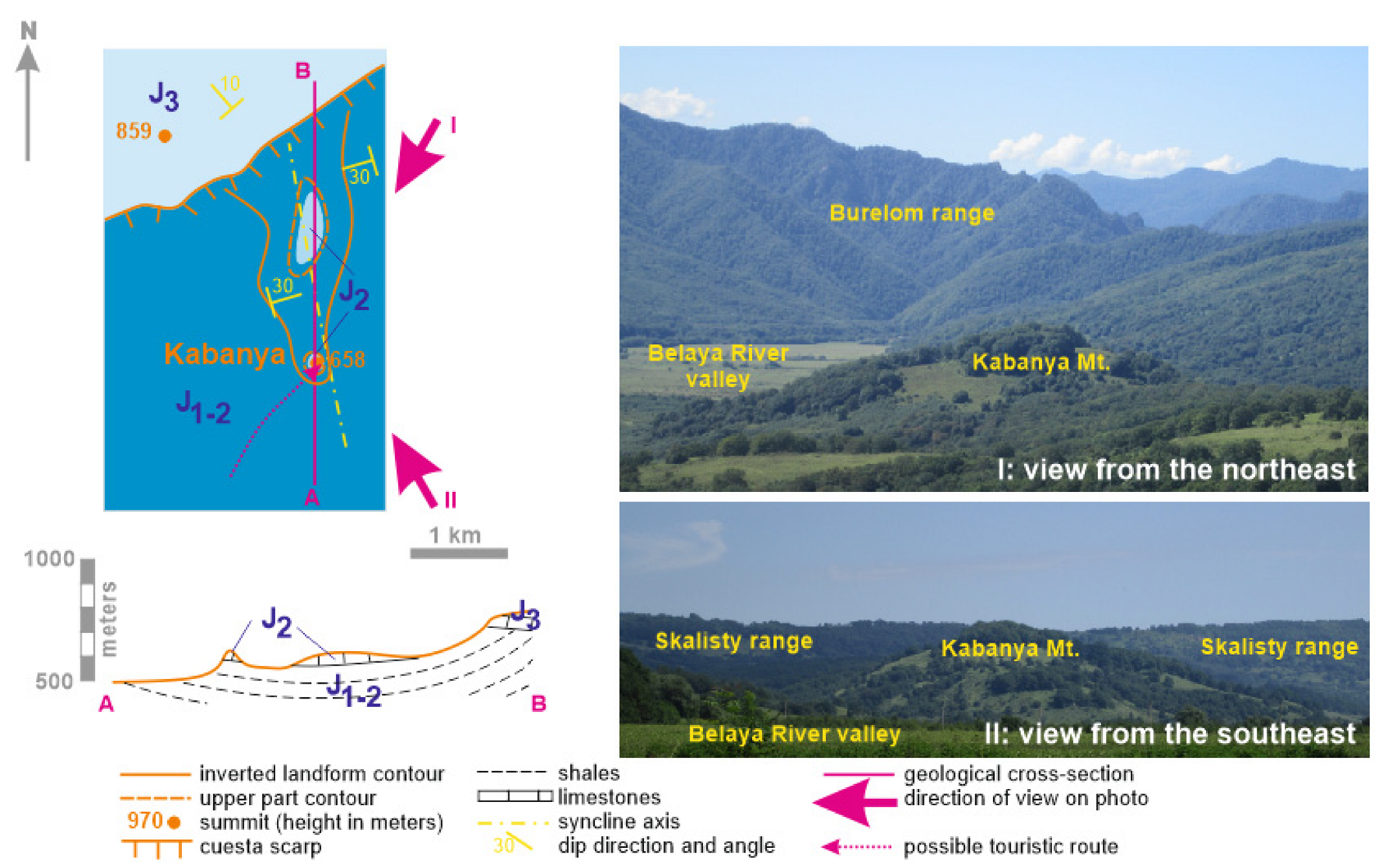
The Kabanya mountain is located in the northwestern part of the study area (Figure 3). It is round in plan, with an elevation of 658 m (Figure 6). The landform is almost isolated from the nearby Skalisty cuesta-type range, although its short, tongue-like branch reaches the Kabanya mountain from the north, and only a small saddle separates them. In fact, this was a single landform until erosion by the local stream formed this saddle. From all other sides, the mountain is surrounded by the wide (up to 2 km), flat surface of the terrace on the left bank of the River Belaya. The Kabanya mountain has a dome-like shape, with only minor topographical irregularities. Hard rocks crop out on its summit. The mountain is located on the opposite side of the valley of the River Belaya, relative to the Gud and Gudok mountains [24]. Deciduous forests cover significant parts of the Kabanya mountain (especially on its western slopes and the peak-like summit), whereas some other parts are covered by tall grass and occasional shrubs. Although a small river, namely, the Doguako (a left tributary of the River Belaya) flows to the south of the mountain, the slopes of the latter are not drained by any stream.
The geological setting and origin of the Kabanya mountain are comparable to those the Gud and Gudok mountains described above (Figure 6). The landform is sculpted in Lower–Middle Jurassic shales capped by Middle Jurassic encrinites, which constitute the same syncline. However, some peculiarities should be noted. The mountain itself does not correspond to the very core of the syncline; the latter occurs beneath the tongue-like branch of the Skalisty range. Apparently, the saddle between the mountain and the branch was formed by activities of some former streams. One of them could have been a tributary of the River Doguako, whereas the other flowed directly to the River Belaya. If the Kabanya mountain is a remnant of a larger landform, the latter would have been identical to the present Gud mountain. The question is why the tongue-like branch does not appear as an individual mountain and retains a connection with the Skalisty range. A possible explanation is that it was linked to the cuesta to the north. A thick package of Upper Jurassic carbonates “fixes” the local topography and makes the steep slope resistant to erosion, even if retreating gradually. The existence of encrinites near the toe of the cliff slows down erosion and, thus, the retreat. The tongue-like branch will isolate only after future northward retreat of the cuesta by 1–2 km. When this happens, this landform will resemble the Gud mountain. This may take a significant length of time, and it cannot be excluded that the encrinites will be totally denudated earlier. In this case, the inverted landform will disappear due to rapid erosion of soft shales.
The Kabanya mountain and the nearby tongue-like branch of the Skalisty range constitute a notable inverted landform, which looks like a remarkable edifice above the flat terrace surface. Apparently, one can have different views of the local uniqueness. The summit of the Kabanya mountain offers a reference locality of Middle Jurassic encrinites with abundant fossils (crinoids, bivalves, etc.), which are unique with respect to sedimentological, palaeontological, and palaeogeographical peculiarities [31]. On this basis, the Kabanya mountain is more valuable geologically than geomorphologically, and it is a diverse geosite with several geoheritage types. It is well accessible by roads and trails from the village of Dakhovskaya in the northeast and the hanging bridge over the River Belaya (close to the Gornaya Derevnya lodge) in the south. Climbing the mountain itself is a bit challenging (see below). This geosite is not subject to any negative influence, except for the natural destruction of encrinites by weathering at the summit. Similar to the previous case, professional interpretation is necessary to realize the uniqueness of this mountain and its essence as an inverted landform. The potential for international research is linked to the unique assemblage of Middle Jurassic marine invertebrates and taphonomic patterns of encrinites, which have been studied only superficially [30,31]. Moreover, encrinite localities on the tongue-like branch of the Skalisty range have yet to be documented. In regard to its smaller size, educational potential is lower in comparison to the Gud mountain, although the Kabanya mountain is more easily accessible. Touristic potential is linked to the possible interest in conquering a small, yet notable landform and for fossil collecting. The Kabanya mountain demonstrates significant aesthetic properties that are linked to its very regular, dome-like shape (looking almost conical from greater distances), the unusual pink color of the encrinites, and scenic wilderness.
The Kabanya mountain is not high (relative height is ~150 m), but climbing is not easy. The slopes are rather gentle (<30°), but tall grass makes movement very difficult, and there are no trails. The tongue-like branch of the Skalisty range is almost inaccessible due to dense vegetation. A possible route may start from the unpaved road at the foot of the Kabanya mountain (southern slopes are most suited for climbing), lead up by an intuitively chosen path, and end at the summit (Figure 6). The eastern slopes are more comfortable for descending. Conquering this mountain and returning would take ~1.5 h for more or less trained hikers (specific climbing skills are not needed), but taking into account the time spent to reach the village of Dakhovskaya or the hanging bridge (hiking from this point is strongly recommended due to outstanding aesthetic landscape properties), the entire trip would take up to 5 h.
4.3. Northwestern Skazhenny Range
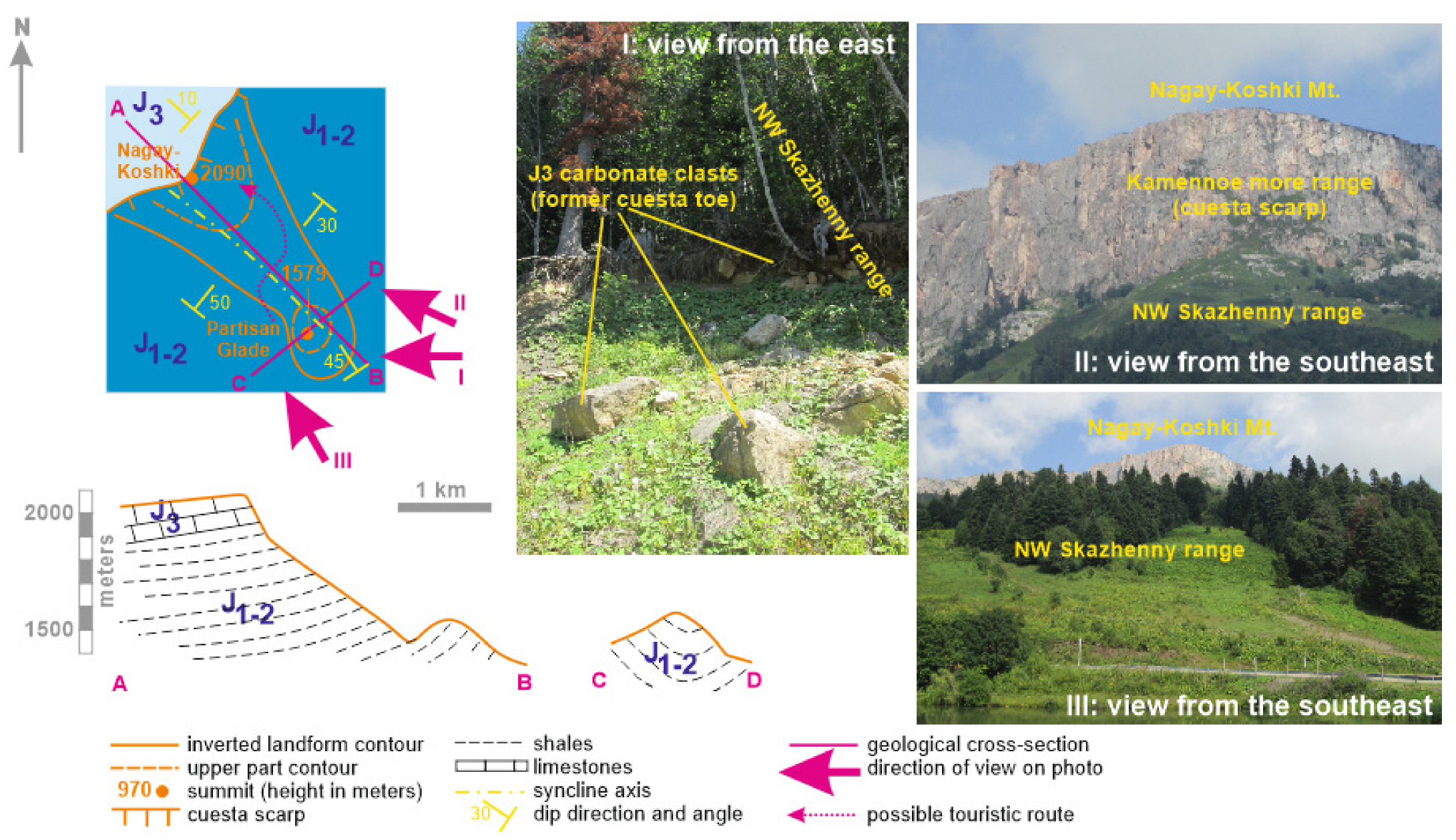
The Skazhenny range is located in the very south of the study area (Figure 3). It is arc-shaped and stretches from the Nagay-Koshki mountain, where it joins the Kamennoe more cuesta-type range to the east. The heights of this range decrease from the west where they exceed 1800 m to the east where they are below 1000 m. Importantly, this range is segmented, and the segments differ morphostructurally. In the present paper, we pay attention to the northwestern segment of this range, i.e., its highest part between the Nagay-Koshki mountain and the Partisan Glade locality. This is an individual landform that stretches as a ridge from the northwest to the northeast (Figure 7). It joins the Kamennoe more range, but at a lower elevation, and the Nagay-Koshki mountain is the highest point of the cuesta scarp, under which the Skazhenny range starts. On the northeastern edge of this segment, there is a small isolated mountain with a height of 1579 m. It is separated from the rest of the segment by a saddle, from which small streams flow towards the River Zholobnaya in the north and the River Armyanka in the south. Although this landform becomes lower in the northeastern direction, it remains more or less symmetrical, with slope angles of up to 50° and a narrow and rounded, almost flat top. Dense mixed forest with a significant number of firs covers this landform almost entirely, although small meadows with tall grass occur locally.
Geologically, the northwestern Skazhenny range differs from the inverted landforms described above. It corresponds to the axis of an asymmetrical, plunging syncline trending from the northwest to the southeast, and, therefore, this is a typical inverted landform. Dip angles are ~50° (varying locally from 30° to 80°, due to second-order deformations) on the southwestern flank, ~30° on the northeastern flank, and ~45° on the southeastern edge. The landform is shaped by erosion from the Lower–Middle Jurassic dark, laminated shales with abundant siderite concretions. These erosion-prone rocks occur abundantly, and the hard Upper Jurassic carbonates dipping to the northwest under angles of 5–10° crop out only in the high and steep scarp of the cuesta (Figure 7). The absence of any capping rocks in the core of the syncline begs the question about the origin of this landform and its inverted essence. In this respect, the Nagay-Koshki mountain should be considered; this occupies a peculiar position, i.e., where the cuesta changes its exposure from the southeast to the east. This marks a kind of topographical protrusion, the direction of which corresponds to the trending of the northwestern Skazhenny range. Multiple carbonate clasts on the slopes of the latter (Figure 7) confirm its previous cover by Upper Jurassic hard rocks, which were denudated together with the cuesta retreat. The remnants of such protrusions are also found in other places along the periphery of the Kamennoe more range [24]. The correspondence of this protrusion to the axis of the plunging syncline may be only occasional. Hard Upper Jurassic limestones “fix” the local topography and determine erosion on the flanks of the landform considered, with preservation of the ridge joined directly to the Nagay-Koshki mountain. It cannot be excluded that carbonate clasts cover some parts of the northwestern Skazhenny range so densely that they protect its slopes from erosion. Future retreat of the cuesta to the northwest will facilitate denudation of this landform, and it will be actively eroded (even erased) by the small tributaries of the rivers Zholobnaya and Armyanka. However, another landform of the same kind will exist near the retreated cuesta.
The northwestern Skazhenny range is an inverted landform with a peculiar origin, and, thus, its uniqueness is indisputable. Its analogs are regionally absent, which makes this landform an important geomorphosite. Additionally, long outcrops of deformed Lower–Middle Jurassic ichnofossil-bearing deposits formed in a deep-marine basin under oxygen-depleted conditions are available at its toes (in road cuttings). This is indicative of stratigraphical, palaeogeographical, and tectonic types of geoheritage. In that light, the northwestern Skazhenny range is both a geomorphosite and complex geosite. It is easily accessible by a paved road. Moreover, the Partisan Glade at the saddle of this landform is a famous locality, with lodges, parking, and an artificial lake. A well-established trail leads from the foot to the very top of the landform; there are some other, but rarely used, trails leading to the Nagay-Koshki. Similar to the other cases, professional interpretation is required to understand this geomorphosite correctly. It is not vulnerable to any negative factor. The scientific importance revolves around specific landform development and geological features. The educational importance of the northwestern Skazhenny range is significant, but it is more closely related to botanical peculiarities. Additionally, outcrops of the shales can be used to explain features of deep-marine sedimentation under oxygen depletion conditions, as well as to train skills in finding ichnofossils. The touristic potential is determined by the possibility to experience hiking on this peculiar landform and to enjoy spectacular panoramas of the surrounding mountains. The aesthetic properties of the site are exceptional and are linked to landscape diversity in shapes and colors (dark-grey shales, light-yellow carbonates, dark-green forest, light-green meadows, and a blue lake), evident wilderness, and openness of the site (Figure 7).
As noted above, the northwestern Skazhenny range is well accessible by a nearby road and several trails. Although its slopes are locally steep, the trail is comfortable for hiking. The space on the top is almost flat. Challenges are linked to the wilderness of the place, especially if one decides to go to the foot of the Nagay-Koshki mountain. The vegetation is rather dense, wild animals (including bears, frequently attracted by food litter left by tourists) can be encountered, and rockfalls from the cuesta scarp cannot be ruled out. The optimal route starts from the Partisan Glade and follows a well-marked trail to the ridge (Figure 7). This may take up to 20–30 min in one direction. However, if one wishes to explore the northeastern slope of the range and the foot of the Nagay-Koshki mountain, the excursion would take up to 5 h, and it requires much better training.
5. Discussion
5.1. Structural Landform Inversion in Mountainous Adygeya
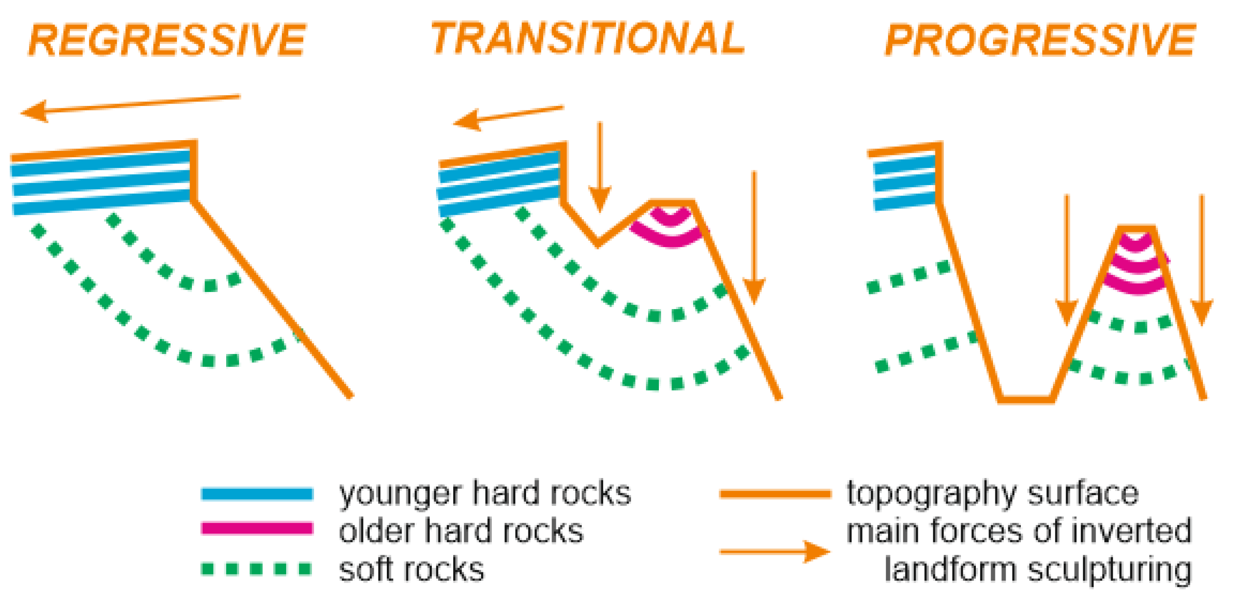
Several inverted landforms are recorded in Mountainous Adygeya (Figure 3), and these seem to be really significant constituents of the local topography. As such, inversion is a characteristic feature of the study area, which adds to its geoheritage value. This structural inversion is controlled both lithologically (soft and hard rock packages) and tectonically (synclines). The interpretations presented above shed light on the complexity of this phenomenon. Uplift of the orogen led to the appearance of a monocline formed of hard Upper Jurassic carbonates and its simultaneous destruction via retreat of cuesta-type ranges. This process facilitated exposure of the underlying soft rocks and the development of the lower level of landforms.
The inverted landforms analyzed in this study occur in three situations (Figure 8). The first of these is when Upper Jurassic carbonates cap a syncline formed of entirely soft rocks (i.e., the northwestern Skazhenny range). In this setting, the inversion can be labeled as regressive because it results from the influence of the retreating landform on the appearing landform, but not from the peculiarities of the latter. Further cuesta retreat will stop inversion. The second situation is when the cuesta retreat over several kilometres does not play a role in the development of the lower-level topography (i.e., Gud and Gudok mountains). Such an inversion is progressive because it is determined by the evolution of landform itself, with the hard rocks in the syncline core. The third situation is transitional, but it is more closely related to progressive inversion because the former requires the presence of some hard rocks capping the lower-level topography (i.e., Kabanya mountain). Previously, the landform constituted by the Gud and Gudok mountains experienced transitional inversion when the cuesta scarp took a more southern position.
Conceptually, regressive inversion seems to be the most important finding, as it indicates the possibility of formation of positive landforms above synclines in the absence of hard rocks in the core of these synclines. In such cases, topographic protrusions from cuesta scarps serve as temporal caps. Such protrusions develop due to the spatially differentiated retreat of cuestas. More generally, the two-level organization of the topography and the possibility of regressive and transitional inversion in the study area result from its structural setting when the softer, intensively deformed shales are overlain by the harder carbonates that are deformed only slightly. The origin of such a structure has yet to be assessed in detail. Either tectonic activity in the second half of the Middle Jurassic or heterogeneous deformation during the Late Cenozoic orogeny (or both) created this relationship between major sedimentary units.
5.2. Further Implications for Geotourism
The inverted landforms of Mountainous Adygeya represent interesting geomorphological phenomena, each having certain touristic potential (see above). Taken together, these geomorphosites permit a fuller understanding of this phenomenon and emphasize its diversity. Mountainous Adygeya can be considered as the area that serves to understand the nature of structural inversion. Other areas across the globe indicate various manifestations of this phenomenon [1,2,3,4,5,6,7,8,9,10]. If so, development of an excursion route focused on the inverted landforms of Mountainous Adygeya appears reasonable. Taking into account that the landforms are large in size, their distant, panoramic viewing is required for their full comprehension. Such an approach can also solve problems of limited internal accessibility of the geomorphosites (see above). Finding appropriate viewpoints, which always help in geotourism [50,51,52], is required for their subsequent inclusion into a geotouristic route.
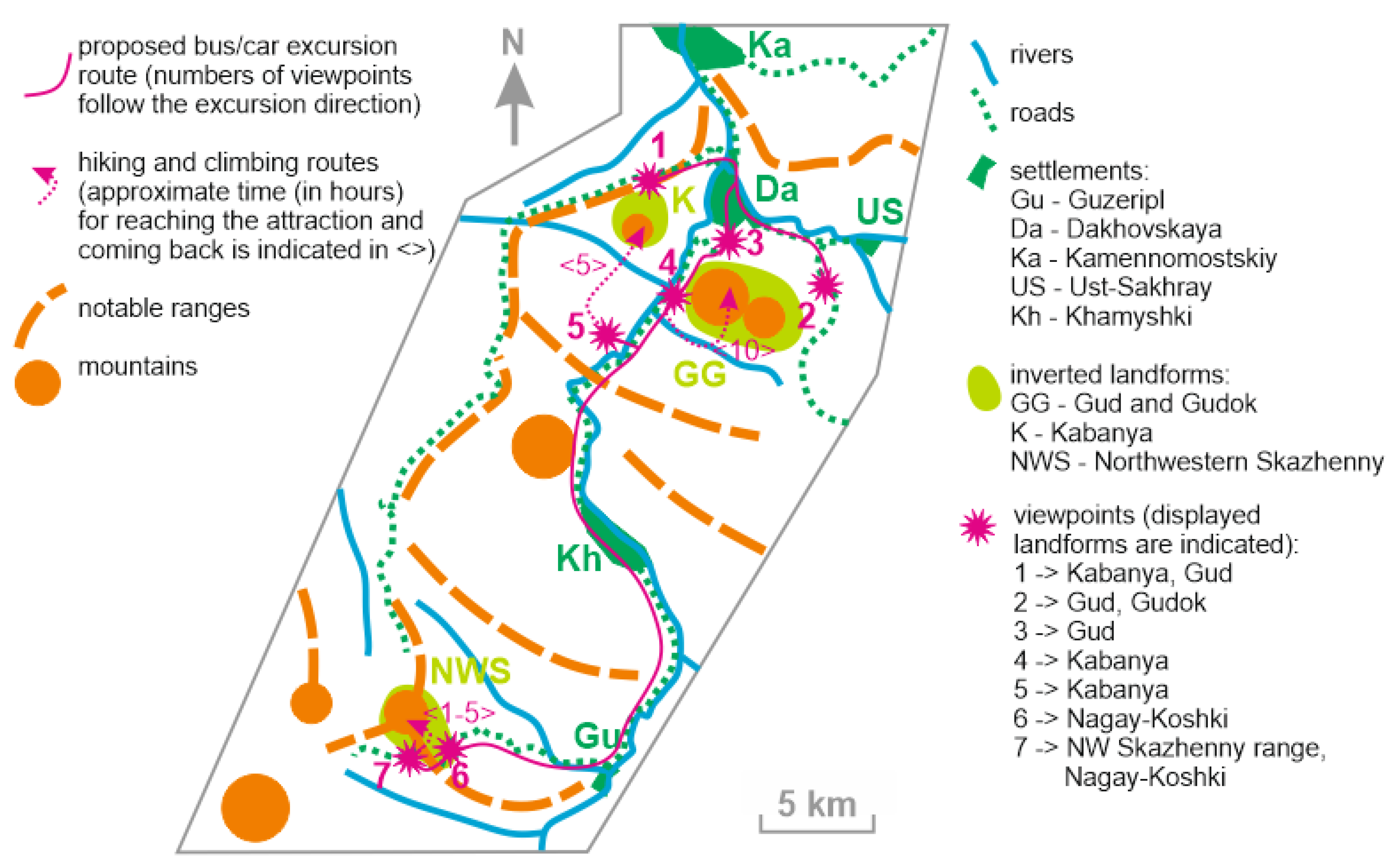
Investigations in Mountainous Adygeya have permitted the specification of seven viewpoints for distant observation of all inverted landforms reported in the present paper (Figure 9). These points offer panoramic and often spectacular views, and they are located on principal roads (each allows bus/car stops and accommodation of groups of visitors). The only exclusion is viewpoint 5, which requires a stop near Gornaya Derevnya lodge and then ~0.5 km of hiking. Reaching viewpoint 2 requires driving along an unpaved road, but the latter is of appropriate quality for all types of cars and buses. Distant observation from these viewpoints is sufficient to understand the landform shapes and to learn about relief inversion in Mountainous Adygeya from any expert in local geology and geomorphology. The car/bus excursion along the proposed geotouristic route with seven stops can take ~3–5 h (depending on the time spent at each point). The rocks and structures are invisible from the majority of the viewpoints (except for points 6 and 7), and thus the excursion can be combined with climbing any mountains along the routes proposed (Figure 5, Figure 6 and Figure 7). A full geotouristic programme would take two days, with one day for car/bus excursion and another for climbing the chosen landform. A range of hotels and lodges for geotourist accommodation are available locally. The peculiarities of climbing the mountains outlined above imply that geotourist activities can be combined with adventure tourism [53,54,55,56,57,58,59]. Undoubtedly, this will diversify the experience of visitors and thus contribute to their overall satisfaction.
The proposed geotouristic excursion may appeal to professional geomorphologists and geologists interested in extending their knowledge of particular phenomena or local geology. It can be demanded even more by organizers of field educational programs at those Russian universities, which use Mountainous Adygeya for training Earth science students. Strengthening the adventure component and visiting the local tourist attractions (biosphere reserve, waterfalls, archaeological sites, etc.) would make the excursion interesting to a broader circle of visitors, including geology amateurs, ecotourists, and some other categories of tourists. It should be stressed that Mountainous Adygeya is already popular among nature-focused tourists [23,60], and thus the proposed geotouristic solutions have certain potential. Regarding some modern concepts [61], these solutions increase the value of ecosystem services of the study area.
5.3. Geobranding Implications
Due to the structural inversion of the progressive type, the Gud and Gudok mountains constitute an isolated landform that dominates the panoramic views of the northern part of the study area. It can be recognized as an outstanding natural object “symbolizing” the geodiversity of Mountainous Adygeya. This qualitative interpretation seems to be crucial for local geobranding, i.e., branding goods, services, and places with notable elements of geodiversity.
The idea of geoproducts has been developed recently in order to relate local production, tourism development, and sustainable geoheritage management. Particularly, this idea (or rather, set of ideas) was analyzed by Farsani et al. [62] and Rodrigues et al. [63], whereas Reynard and Coratza [64] noted its relevance to geomorphosites. Although geoproducts are often linked to geoparks, these can be demanded in many geoheritage-rich areas with growing tourism. Apparently, usage of notable geodiversity elements for branding local products, especially popular among tourists, contributes indirectly to tourist interest in geodiversity and its conservation; this serves the purpose of maintaining the identity of the destination.
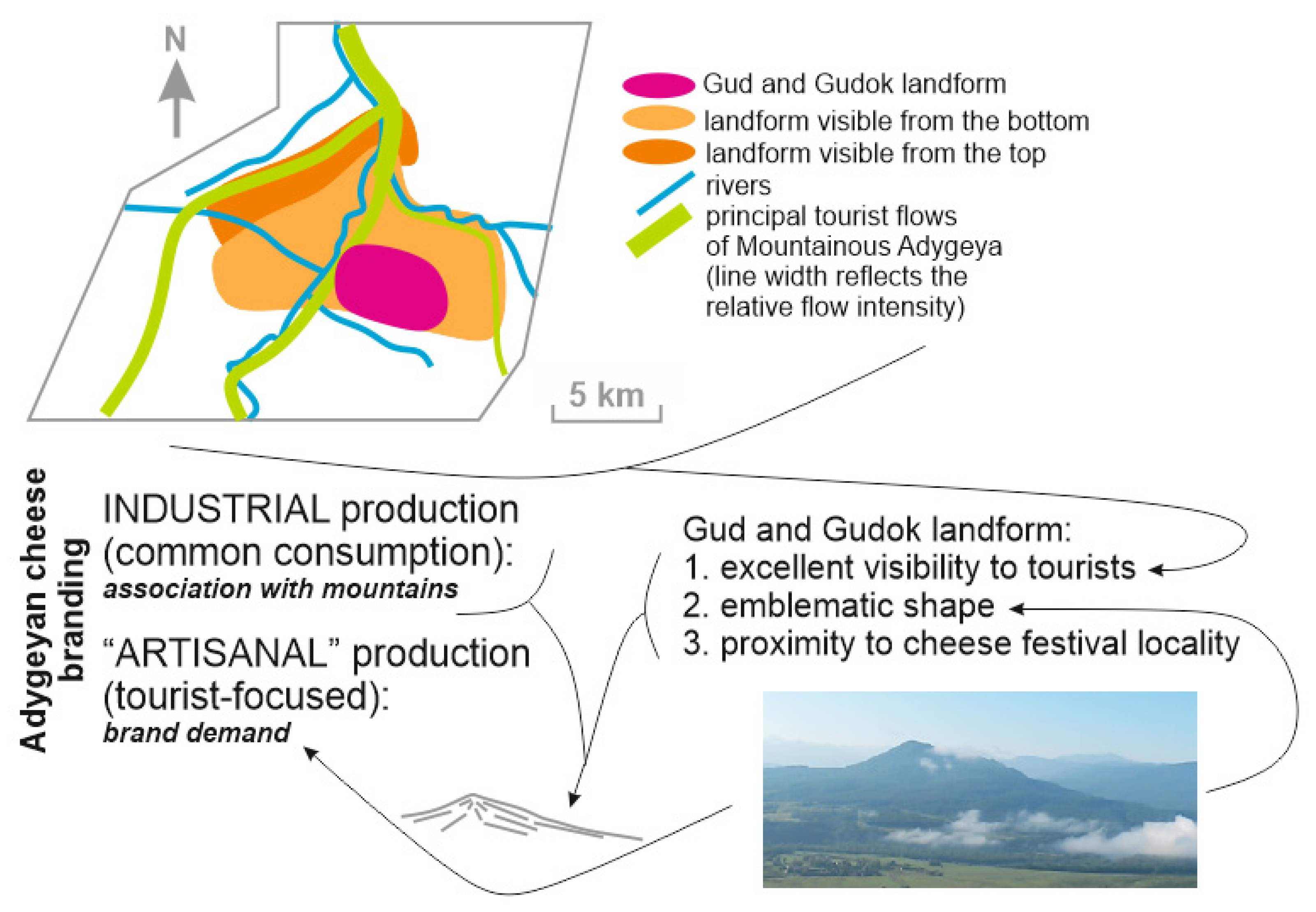
Not only is Mountainous Adygeya a popular tourist destination of the Russian South, it is also famous for its specific food, including the so-called Adygeyan cheese. This kind of cheese, not necessarily produced in Adygeya, is expected there by visitors. Adygeya is one of the main cheese-producing regions of Russia, and a special Adygeyan Cheese Festival [65] is organized there regularly in the vicinity of Dakhovskaya village, i.e., directly in the study area. In addition to industrial cheese production, there is also significant production by small enterprises chiefly catering to tourists. This “artisanal” cheese is sold in local shops and by local vendors near the majority of tourist attractions and even along the principal roads, and it serves as a kind of local souvenir that is very popular among tourists despite its moderate to high price (Figure 10). Indeed, this cheese needs special branding to strengthen its links to the particular tourist destination and to distinguish it from Adygeyan cheese as a particular kind of cheese (not all this “artisanal” cheese is truly Adygeyan cheese, or, rather, it is Adygeyan only in geographical origin).
The Gud and Gudok landform can be used for the purpose of “artisanal” cheese branding (Figure 11). This landform boasts outstanding visibility from the main roads, many attractions, and accommodation sites, i.e., it is exposed to all principal tourist flows. This landform has an emblematic shape. Analysis of dozens of food and beverage products (butter, mineral water, sausages, teas, etc.) from different Russian mountainous regions of the Northern Caucasus and southern Siberia implies the frequent use of idealized mountains as logos or cover images. In about one third of the cases, these are isolated mountains with well-shaped, but rather gentle slopes, which generally match the view of the Gud and Gudok landform. Organizing a cheese festival not far from the northern toes of the Gud mountain should also be noted. The analysis of logos and images on package covers of the industrially produced Adygeyan cheese implies that mountains are found on almost all of them, i.e., there is a strong association between this sort of cheese and mountains. Taking into account these lines of evidence, it appears very logical to use the stylized images of the Gud and Gudok landform for the purposes of branding the “artisanal” cheese offered to tourists in Mountainous Adygeya (Figure 11) and thus to make this cheese a kind of geoproduct.
6. Conclusions
Our examination of inverted landforms in Mountainous Adygeya allows us to make three general conclusions. First, structural landform inversion in the study area is determined by the existence of Middle Jurassic encrinites in syncline cores and/or Upper Jurassic carbonates forming cuestas. Second, regressive, progressive, and transitional types of inverted landforms are distinguished. Third, inverted landforms constitute an important portion of the geoheritage of Mountainous Adygeya, which can be exploited for the purposes of geotourism and used for cheese branding.
Future research may be linked to a comparison of inverted landforms in Mountainous Adygeya with those in other regions. This will help to understand the inversion phenomenon more comprehensively, as well as to provide better arguments in favor of the related geoheritage value. In particular, it appears to be very interesting to learn whether differences between regressive, progressive, and transitional inversion are reasonable only regionally (due to geological peculiarities of the study area) or whether these have some general meaning.
Author Contributions
Conceptualization, D.A.R.; methodology, D.A.R. and V.A.E.; investigation, D.A.R. and A.V.M.; writing—original draft preparation, D.A.R., A.V.M. and V.A.E.; project administration, D.A.R. All authors have read and agreed to the published version of the manuscript.
Funding
This research received no external funding.
Institutional Review Board Statement
Not applicable.
Informed Consent Statement
Not applicable.
Data Availability Statement
Not applicable.
Conflicts of Interest
The authors declare no conflict of interest.
References
- Cundari, A.; Ollier, C.D. Inverted relief due to lava flows along valleys. Aust. Geogr. 1970, 11, 291–293. [Google Scholar] [CrossRef]
- Pain, C.F.; Ollier, C.D. Inversion of relief—A component of landscape evolution. Geomorphology 1995, 12, 151–165. [Google Scholar] [CrossRef]
- van Wyk de Vries, B.; Karatson, D.; Gouard, C.; Nemeth, K.; Rapprich, V.; Aydar, E. Inverted volcanic relief: Its importance in illustrating geological change and its geoheritage potential. Int. J. Geoherit. Parks 2022, 10, 47–83. [Google Scholar] [CrossRef]
- Butt, C.R.M.; Bristow, A.P.J. Relief inversion in the geomorphological evolution of sub-Saharan West Africa. Geomorphology 2013, 185, 16–26. [Google Scholar] [CrossRef]
- Schwarz, T. Ferricrete formation and relief inversion: An example from Central Sudan. Catena 1994, 21, 257–268. [Google Scholar] [CrossRef]
- Zaki, A.S.; Giegengack, R. Inverted topography in the southeastern part of the Western Desert of Egypt. J. Afr. Earth Sci. 2016, 121, 56–61. [Google Scholar] [CrossRef]
- Wang, Z.-T.; Lai, Z.-P.; Qu, J.-J. Inverted relief landforms in the Kumtagh Desert of northwestern China: A mechanism to estimate wind erosion rates. Geol. J. 2017, 52, 131–140. [Google Scholar] [CrossRef]
- Karim, K.H.; Khanaqa, P.A. Syncline contribution to mountain peak building: Examples from Western Zagros, Kurdistan Region, Northeastern Iraq. Arab. J. Geosci. 2017, 10, 375. [Google Scholar] [CrossRef]
- Froede, C.R., Jr.; Rucker, B.R. Iron Mountain, Santa Rosa County, Florida: A paleogroundwater table inverted relief feature. Southeast. Geol. 2006, 44, 137–145. [Google Scholar]
- Lucchitta, I.; Holm, R. Re-evaluation of exotic gravel and inverted topography at Crooked Ridge, northern Arizona: Relicts of an ancient river of regional extent. Geosphere 2020, 16, 533–545. [Google Scholar] [CrossRef] [Green Version]
- Bussard, J.; Giaccone, E. Assessing the ecological value of dynamic mountain geomorphosites. Geogr. Helv. 2021, 76, 385–399. [Google Scholar] [CrossRef]
- Kubalíková, L.; Kirchner, K. Geosite and geomorphosite assessment as a tool for geoconservation and geotourism purposes: A case study from Vizovickávrchovina Highland (Eastern Part of the Czech Republic). Geoheritage 2016, 8, 5–14. [Google Scholar] [CrossRef]
- Madeira, M.R.; Correa, E.A.; Simon, A.L.H. Spatial concentration of geomorphological heritage elements in Guaritas do Camaquã geomorphosite (Rio Grande do sul—Brazil). Rev. Bras. Geomorfol. 2021, 22, 275–295. [Google Scholar]
- Morino, C.; Coratza, P.; Soldati, M. Landslides, a Key Landform in the Global Geological Heritage. Front. Earth Sci. 2022, 10, 864760. [Google Scholar] [CrossRef]
- Panizza, M. Geomorphosites: Concepts, methods and examples of geomorphological survey. Chin. Sci. Bull. 2001, 46, 4–6. [Google Scholar] [CrossRef]
- Pereira, P.; Pereira, D. Methodological guidelines for geomorphosite assessment. Geomorphol. Relief Process. Environ. 2010, 2, 215–222. [Google Scholar] [CrossRef] [Green Version]
- Reynard, E.; Coratza, P.; Giusti, C. Geomorphosites and geotourism. Geoheritage 2011, 3, 129–130. [Google Scholar] [CrossRef] [Green Version]
- Reynard, E.; Coratza, P.; Hobléa, F. Current research on geomorphosites. Geoheritage 2016, 8, 1–3. [Google Scholar] [CrossRef] [Green Version]
- Rypl, J.; Kirchner, K.; Dvorácková, S. Geomorphological inventory as a tool for proclaiming geomorphosite (a case study of Mt. Myslivna in the Novohradskéhory Mts.—Czech Republic). Geoheritage 2016, 8, 393–400. [Google Scholar] [CrossRef]
- Ruban, D.A. Quantification of geodiversity and its loss. Proc. Geol. Assoc. 2010, 121, 326–333. [Google Scholar] [CrossRef]
- Cipriani, A.; Roncacè, S. The dolines of Campoli Appennino (Frosinone, Italy): A geo-historical overview. Rend. Online Soc. Geol. Ital. 2020, 52, 77–102. [Google Scholar] [CrossRef]
- Mikhailenko, A.V.; Ruban, D.A.; Ermolaev, V.A. Accessibility of geoheritage sites—A methodological proposal. Heritage 2021, 4, 1080–1091. [Google Scholar] [CrossRef]
- Bedanokov, M.K.; Chich, S.K.; Chetyz, D.Y.; Trepet, S.A.; Lebedev, S.A.; Kostianoy, A.G. Physicogeographical characteristics of the Republic of Adygea. Handb. Environ. Chem. 2020, 106, 19–55. [Google Scholar]
- Ruban, D.A. Mountains Ranges and Summits of the Northeastern Periphery of the Lagonaki Highland; DGTU-Print: Rostov-on-Don, Russia, 2020. (In Russian) [Google Scholar]
- Duszyński, F.; Migoń, P.; Strzelecki, M.C. Escarpment retreat in sedimentary tablelands and cuesta landscapes—Landforms, mechanisms and patterns. Earth-Sci. Rev. 2019, 196, 1028. [Google Scholar] [CrossRef]
- Alekseeva, A.E.; Ershov, A.V.; Linev, D.N. Numerical modeling of uplift and erosion at the Western Caucasus orogen in the Neogene-Quaternary. Mosc. Univ. Geol. Bull. 2014, 69, 213–218. [Google Scholar] [CrossRef]
- Ismail-Zadeh, A.; Adamia, S.; Chabukiani, A.; Chelidze, T.; Cloetingh, S.; Floyd, M.; Gorshkov, A.; Gvishiani, A.; Ismail-Zadeh, T.; Kaban, M.K.; et al. Geodynamics, seismicity, and seismic hazards of the Caucasus. Earth-Sci. Rev. 2020, 207, 103222. [Google Scholar] [CrossRef]
- Van Hinsbergen, D.J.J.; Torsvik, T.H.; Schmid, S.M.; Matenco, L.C.; Maffione, M.; Vissers, R.L.M.; Gurer, D.; Spakman, W. Orogenic architecture of the Mediterranean region and kinematic reconstruction of its tectonic evolution since the Triassic. Gondwana Res. 2020, 81, 79–229. [Google Scholar] [CrossRef]
- Popov, Y.V.; Pustovit, O.E.; Tereshchenko, V.A. Accessory chrome spinels of serpentinites of tectonic melange of the Dakhov uplift (Greater Caucasus). Geol. Geofiz. Yuga Ross. 2020, 10, 38–55. [Google Scholar]
- Rostovtsev, K.O.; Agaev, V.B.; Azarian, N.R.; Babaev, R.G.; Besnosov, N.V.; Hassanov, N.A.; Zesashvili, V.I.; Lomize, M.G.; Paitschadze, T.A.; Panov, D.I.; et al. Jurassic of the Caucasus; Nauka: St. Petersburg, Russia, 1992. (In Russian) [Google Scholar]
- Ruban, D.A. Jurassic encrinites and shoreline shifts in the Greater Caucasus basin. Stratigr. Sedimentol. Oil-Gas Basins 2012, 2, 72–84. [Google Scholar]
- Adamia, S.; Alania, V.; Chabukiani, A.; Kutelia, Z.; Sadradze, N. Great Caucasus (Cavcasioni): A Long-lived North-Tethyan Back-Arc Basin. Turk. J. Earth Sci. 2011, 20, 611–628. [Google Scholar] [CrossRef]
- Golonka, J. Plate tectonic evolution of the southern margin of Eurasia in the Mesozoic and Cenozoic. Tectonophysics 2004, 381, 235–273. [Google Scholar] [CrossRef]
- Yasamanov, N.A. Landscape-Climatic Conditions of the Jurassic, the Creaceous, and the Paleogene in the South of the USSR; Nedra: Moskva, USSR, 1978. (In Russian) [Google Scholar]
- Kazmin, V.G.; Tikhonova, N.F. Evolution of Early Mesozoic back-arc basins in the Black Sea—Caucasus segment of a Tethyan active margin. Geol. Soc. Spec. Publ. 2006, 260, 179–200. [Google Scholar] [CrossRef]
- Okay, A.I.; Nikishin, A.M. Tectonic evolution of the southern margin of Laurasia in the Black Sea region. Int. Geol. Rev. 2015, 57, 1051–1076. [Google Scholar] [CrossRef]
- Saintot, A.; Brunet, M.-F.; Yakovlev, F.; Sébrier, M.; Stephenson, R.; Ershov, A.; Chalot-Prat, F.; McCann, T. The Mesozoic-Cenozoic tectonic evolution of the Greater Caucasus. Geol. Soc. Lond. Mem. 2006, 32, 277–289. [Google Scholar] [CrossRef] [Green Version]
- Vasey, D.A.; Cowgill, E.; Cooper, K.M. A preliminary framework for magmatism in modern continental back-arc basins and its application to the Triassic-Jurassic tectonic evolution of the Caucasus. Geochem. Geophys. Geosyst. 2021, 22, e2020GC009490. [Google Scholar] [CrossRef]
- Brilha, J. Inventory and quantitative assessment of geosites and geodiversity sites: A review. Geoheritage 2016, 8, 119–134. [Google Scholar] [CrossRef] [Green Version]
- Henriques, M.H.; dos Reis, R.P.; Garcia, G.G.; Joao, P.; Marques, R.M.; Custodio, S. Developing paleogeographic heritage concepts and ideas through the Upper Jurassic record of the Salgado and Consolacao geosites (Lusitanian Basin, Portugal). Resour. Policy 2022, 76, 102594. [Google Scholar] [CrossRef]
- Prosser, C.; Murphy, M.; Larwood, J. Geological Conservation: A Guide to Good Practice; English Nature: Peterborough, UK, 2006. [Google Scholar]
- Mucivuna, V.C.; Garcia, M.D.G.M.; Reynard, E. Comparing quantitative methods on the evaluation of scientific value in geosites: Analysis from the Itatiaia National Park, Brazil. Geomorphology 2022, 396, 107988. [Google Scholar] [CrossRef]
- Warowna, J.; Zglobicki, W.; Kolodynska-Gawrysiak, R.; Gajek, G.; Gawrysiak, L.; Telecka, M. Geotourist values of loess geoheritage within the planned Geopark Malopolska Vistula River Gap, E Poland. Quat. Int. 2016, 399, 46–57. [Google Scholar] [CrossRef]
- Kirillova, K.; Fu, X.; Lehto, X.; Cai, L. What makes a destination beautiful? Dimensions of tourist aesthetic judgment. Tour. Manag. 2014, 42, 282–293. [Google Scholar] [CrossRef]
- Bollati, I.; Zucali, M.; Giovenco, C.; Pelfini, M. Geoheritage and sport climbing activities: Using the Montestrutto cliff (Austroalpine domain, Western Alps) as an example of scientific and educational representativeness. Ital. J. Geosci. 2014, 133, 187–199. [Google Scholar] [CrossRef]
- Panizza, V.; Mennella, M. Assessing geomorphosites used for rock climbing. The example of Monteleone Rocca Doria (Sardinia, Italy). Geogr. Helv. 2007, 62, 181–191. [Google Scholar] [CrossRef] [Green Version]
- Ruban, D.A.; Ermolaev, V.A. Unique geology and climbing: A literature review. Geosciences 2020, 10, 259. [Google Scholar] [CrossRef]
- Bentivenga, M.; Palladino, G.; Prosser, G.; Guglielmi, P.; Geremia, F.; Laviano, A. A Geological Itinerary Through the Southern Apennine Thrust Belt (Basilicata—Southern Italy). Geoheritage 2017, 9, 1–17. [Google Scholar] [CrossRef]
- Palladino, G.; Prosser, G.; Bentivenga, M. The Geological Itinerary of Sasso di Castalda: A Journey into the Geological History of the Southern Apennine Thrust-belt (Basilicata, Southern Italy). Geoheritage 2013, 5, 47–58. [Google Scholar] [CrossRef]
- Fuertes-Gutiérrez, I.; Fernández-Martínez, E. Geosites inventory in the Leon Province (Northwestern Spain): A tool to introduce geoheritage into regional environmental management. Geoheritage 2010, 2, 57–75. [Google Scholar] [CrossRef]
- Migoń, P.; Pijet-Migoń, E. Viewpoint geosites—Values, conservation and management issues. Proc. Geol. Assoc. 2017, 128, 511–522. [Google Scholar] [CrossRef]
- Mikhailenko, A.V.; Ruban, D.A. Environment of viewpoint geosites: Evidence from the Western Caucasus. Land 2019, 8, 93. [Google Scholar] [CrossRef] [Green Version]
- Bichler, B.F.; Peters, M. Soft adventure motivation: An exploratory study of hiking tourism. Tour. Rev. 2021, 76, 473–488. [Google Scholar] [CrossRef]
- Buckley, R. Adventure tourism as a research tool in non-tourism disciplines. Tour. Recreat. Res. 2014, 39, 39–49. [Google Scholar] [CrossRef]
- Gross, S.; Sand, M. Adventure tourism: A perspective paper. Tour. Rev. 2020, 75, 153–157. [Google Scholar] [CrossRef]
- Ponte, J.; Couto, G.; Sousa, Á.; Pimentel, P.; Oliveira, A. Idealizing adventure tourism experiences: Tourists’ self-assessment and expectations. J. Outdoor Recreat. Tour. 2021, 35, 100379. [Google Scholar] [CrossRef]
- Janowski, I.; Gardiner, S.; Kwek, A. Dimensions of adventure tourism. Tour. Manag. Perspect. 2021, 37, 100776. [Google Scholar] [CrossRef]
- Rantala, O.; Rokenes, A.; Valkonen, J. Is adventure tourism a coherent concept? A review of research approaches on adventure tourism. Ann. Leis. Res. 2018, 21, 539–552. [Google Scholar] [CrossRef]
- Rantala, O.; Hallikainen, V.; Ilola, H.; Tuulentie, S. The softening of adventure tourism. Scand. J. Hosp. Tour. 2018, 18, 343–361. [Google Scholar] [CrossRef] [Green Version]
- Ivlieva, O.V.; Shmytkova, A.V.; Sukhov, R.I.; Kushnir, K.V.; Grigorenko, T.N. Assessing the tourist and recreational potential in the South of Russia. E3S Web Conf. 2020, 208, 05013. [Google Scholar] [CrossRef]
- Ignatyeva, M.; Yurak, V.; Dushin, A. Valuing natural resources and ecosystem services: Systematic review of methods in use. Sustainability 2022, 14, 1901. [Google Scholar] [CrossRef]
- Farsani, N.T.; Mortazavi, M.; Bahrami, A.; Kalantary, R.; Bizhaem, F.K. Traditional crafts: A tool for geo-education in geotourism. Geoheritage 2017, 9, 577–584. [Google Scholar] [CrossRef]
- Rodrigues, J.; Neto de Carvalho, C.; Ramos, M.; Ramos, R.; Vinagre, A.; Vinagre, H. Geoproducts—Innovative development strategies in UNESCO Geoparks: Concept, implementation methodology, and case studies from Naturtejo Global Geopark, Portugal. Int. J. Geoheritage Parks 2021, 9, 108–128. [Google Scholar] [CrossRef]
- Reynard, E.; Coratza, P. Scientific research on geomorphosites. A review of the activities of the IAG working group on geomorphosites over the last twelve years. Geogr. Fis. Din. Quat. 2013, 36, 159–168. [Google Scholar]
- Ermolaev, V.A.; Yashalova, N.N.; Ruban, D.A. Cheese as a tourism resource in Russia: The first report and relevance to sustainability. Sustainability 2019, 11, 5520. [Google Scholar] [CrossRef] [Green Version]
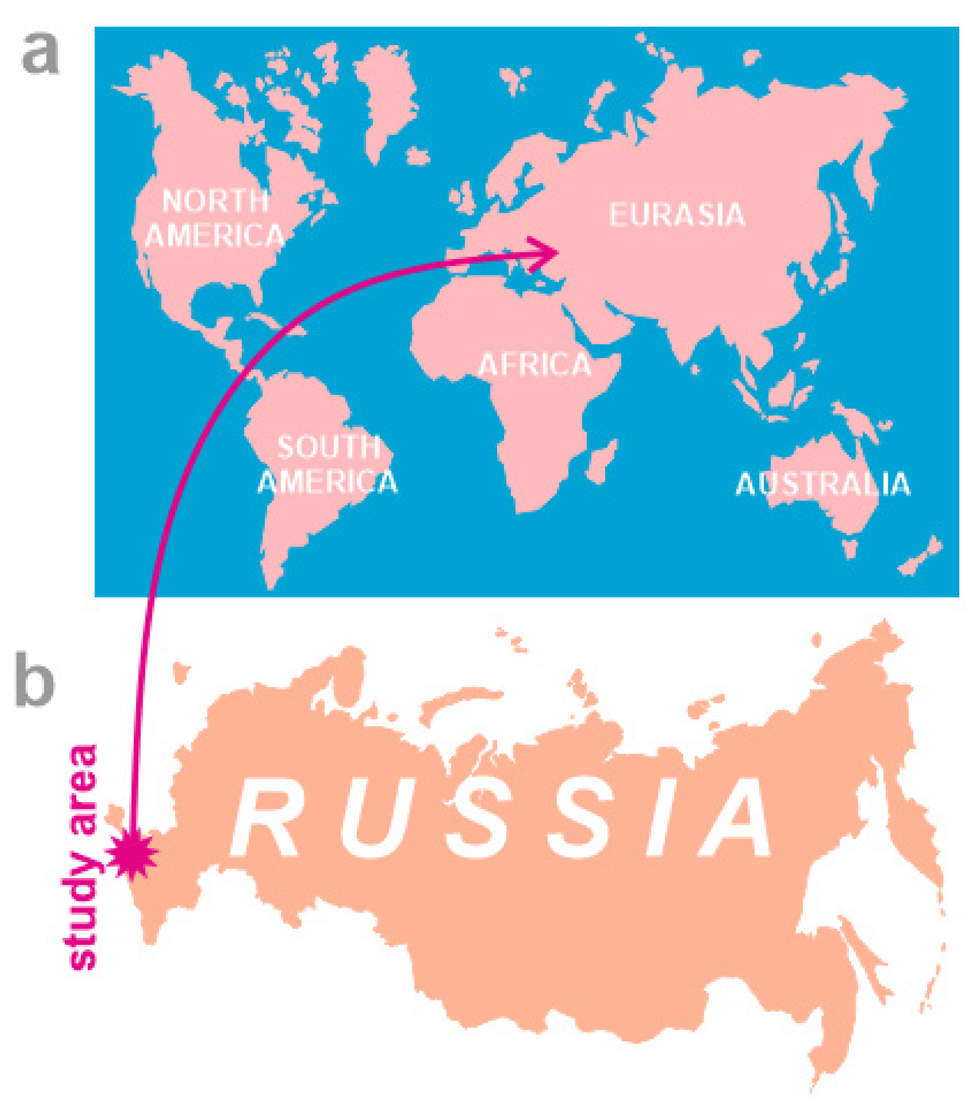
Figure 1.
Study area in the world (a) and Russia (b).

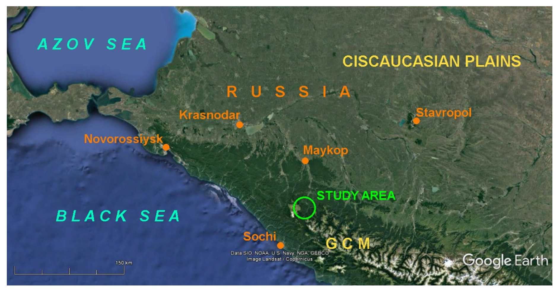
Figure 2.
Geographical location of the study area (source of base satellite images: Google Earth Engine). Abbreviation: GCM—Greater Caucasus Mountains.
Figure 2.
Geographical location of the study area (source of base satellite images: Google Earth Engine). Abbreviation: GCM—Greater Caucasus Mountains.

Figure 3.
Principal landforms (a) and geological setting (b) of the study area.

Figure 4.
Composite stratigraphical section of the Jurassic deposits dominating the study area (based on descriptions in [30]).
Figure 4.
Composite stratigraphical section of the Jurassic deposits dominating the study area (based on descriptions in [30]).

Figure 5.
Outline of the Gud and Gudok mountains.

Figure 6.
Outline of the Kabanya mountain.

Figure 7.
Outline of the northwestern Skazhenny range.

Figure 8.
Conceptual scheme showing established types of structural landform inversion.

Figure 9.
Proposed geotouristic solution for the inverted landforms of the study area.

Figure 10.
Various kinds of the “artisanal” cheese produced in Adygeya.

Figure 11.
Schematic argumentation for the utility of the Gud and Gudok landform for thebranding of local products such as the famous Adygeyan cheese (see Figure 3a for the basic legend of the insert map showing the northern part of the study area).
Figure 11.
Schematic argumentation for the utility of the Gud and Gudok landform for thebranding of local products such as the famous Adygeyan cheese (see Figure 3a for the basic legend of the insert map showing the northern part of the study area).

Publisher’s Note: MDPI stays neutral with regard to jurisdictional claims in published maps and institutional affiliations. |
© 2022 by the authors. Licensee MDPI, Basel, Switzerland. This article is an open access article distributed under the terms and conditions of the Creative Commons Attribution (CC BY) license (https://creativecommons.org/licenses/by/4.0/).
Share and Cite
MDPI and ACS Style
Ruban, D.A.; Mikhailenko, A.V.; Ermolaev, V.A. Inverted Landforms of the Western Caucasus: Implications for Geoheritage, Geotourism, and Geobranding. Heritage 2022, 5, 2315-2331. https://doi.org/10.3390/heritage5030121
AMA Style
Ruban DA, Mikhailenko AV, Ermolaev VA. Inverted Landforms of the Western Caucasus: Implications for Geoheritage, Geotourism, and Geobranding. Heritage. 2022; 5(3):2315-2331. https://doi.org/10.3390/heritage5030121
Chicago/Turabian StyleRuban, Dmitry A., Anna V. Mikhailenko, and Vladimir A. Ermolaev. 2022. "Inverted Landforms of the Western Caucasus: Implications for Geoheritage, Geotourism, and Geobranding" Heritage 5, no. 3: 2315-2331. https://doi.org/10.3390/heritage5030121