


Ghost Mines for Geoheritage Enhancement in the Umbria Region (Central Italy)

Department of Physics and Geology, University of Perugia, Via A. Pascoli, s.n.c., 06123 Perugia, Italy
*
Authors to whom correspondence should be addressed.
†
These authors contributed equally to this work.
Geosciences 2023, 13(7), 208; https://doi.org/10.3390/geosciences13070208
Submission received: 23 May 2023
/
Revised: 13 June 2023
/
Accepted: 3 July 2023
/
Published: 11 July 2023
(This article belongs to the Special Issue Geoheritage and Geotourism Resources: Education, Recreation, Sustainability II)
Abstract
:The paper proposes a method to valorize abandoned mines whose traces were lost in the territory and in the collective memory. We selected two case studies in the Umbria region (central Italy) that were used as examples. The evidence of the presence of lignite mines on the Upper Tiber River Valley (northern Umbria) has been completely erased, and since they were located in rural areas, they represent an interesting challenge regarding recovering the memory of the places and proposing a no-longer-existent site as a geosite. The recovery and valorization of historical documents of the two lignite mines (Caiperino–Terranera and Carsuga) and their conversion into a digital format was carried out before constructing a geolocalized database in a GIS environment. This framework is the starting point for a promising dissemination process via a digital media app, using multimedia contents as video, 3D models and the principles of augmented reality (AR) to enhance the touristic or didactic experience and promote the cultural heritage of the territory by keeping the memory of ’ghost places’.
1. Introduction
Geoheritage is a part of the identified geodiversity of the Earth, where a value is recognized and conservation is needed [1,2,3,4]. In order to assess geoheritage, the evaluation of geodiversity [5,6,7,8] and the identification of geosites [9,10,11] are crucial steps. A geosite is always the expression of the landscape where it is located; this is particularly true when the geosite corresponds to a landform (geomorphosite, [7]).
As a matter of fact, geosites can be damaged or destroyed by vegetation encroachment and natural erosion but also by degradation by infrastructure and housing buildings. In addition, some geosites may be destroyed simply because local communities do not know or understand their value. A valid example of risk analysis of degradation is applied in La Rioja, Spain. In this case study, the risk of the degradation of the geological characteristics was attributed to intrinsic factors (fragility) and to extrinsic factors (vulnerability), both natural and anthropogenic, and was affected by public use. According to this preliminary analysis, it is possible to plan the conservation actions, such as recording and rescuing the geosites where damage is inevitable and protecting and promoting the areas where there are preliminary conditions, allowing for the preservation of the geosites [12].
As the landscape is the result of several factors (endogenous, exogenous, natural and anthropic) developing at different time steps, the evolution of geomorphosites also changes over time as well [13]. In those areas where the human presence is widespread and where man becomes the most relevant morphogenetic factor, the landscape may evolve in a short time, if compared with natural evolution. In such contexts, the probability of losing track of the geoheritage increases. Nevertheless, also in these cases, if the natural landscape evolution together with the anthropogenic impact may partially or totally erase the evidence of geosites [14], their contribution in the current landscape layout is undeniable and should be addressed.
Existing geosites can be subjected to physical and biological hazards such as geomorphological erosion and deposition activity or vegetation growth with a possible increase in the efficiency of these natural processes due to climate change. Moreover, anthropic hazards due to human activity, such as infilling or earthwork, river management or coastal protection, may permanently delete geosites. Conservation is a fundamental key to the enhancement and dissemination of the geoheritage [12]. If the preservation of an existing geosite might be complex, but feasible, the protection of a geosite that has been jeopardized by the aforementioned factors is a much more complex issue. Key considerations include: why does it make sense to keep the memory of something that no longer exists? How is it possible to evaluate the role of a site in the current landscape configuration? An important issue is with regard to retrieving the necessary documentation for defining the right value of the extinct site, especially in the case where the geosite only has a local value. Key clues might be derived from the inherited landforms that are witnesses of the Earth’s evolution; for this reason, they should be recorded and taken into account in the geoheritage evaluation [13].
In the scientific literature, geosites are classified and described using different principles and values [15], including selected closed mines that have been considered as geosites. Nevertheless, the roles of mining activity and, more in general, of the extractive industries (ore mineral, oil and gas exploitation) have been identified as a negative factor on the environment and on the World Heritage. The UNESCO World Heritage Committee established the incompatibility between the mineral exploitation and the World Heritage status—although some old mines were declared World Heritage—since the global exploration and exploitation of mining, oil and gas has been recognized as the seventh most relevant reason affecting the areas declared as World Heritage. On the other hand, numerous actions have been promoted in many countries for the recovery of dismissed mining areas [16,17,18]. Mining closure is not necessarily the final step of the mining activity but, on the contrary, should be the first phase of the inclusion of mines in the geoheritage list of a country [6,19]. The mining activities collect different types of values, where the first and most direct are the minerals and lithology that remain along the excavation tunnels and in the surrounding areas. These materials can be observed in situ in open pits, along unfilled tunnels or in exhibitions and museums close to the tailing piles. Moreover, the information provided by the mined material is not only limited to the description of the single mineral or lithotype but is the trigger for illustrating the geological setting of a wider area around the mining site.
In addition to the geological value, several values can be associated to the mining sites. A first group includes values related to the activity: aesthetic and architectural, antiquity, duration of mining activity, economic, technological. As an example, the Zollverein Coal Mine Industrial Complex (Essen Germany) has been included in 2011 in the World Heritage List for the excellent architectural quality of its buildings [20]. In addition, the duration of the mining activity and the starting period determine the historical value together with the scale of the operation, the social impact and also the economic impact of the mine in the area, in the country or worldwide. The technological value is associated with innovations due to the industrial and technical improvements derived from the mining activity, such as the need to reach deeper layers, or to have faster extraction and processing times. The memory preservation of the past mining sites also has a social value since abandoned mines have a social context, especially in rural communities [21]. Last but not least, the mining sites are a very important factor as landscape modifiers. The elements characterizing the mining activity as extraction sites, areas of accumulation of waste, infrastructure and mining villages change the natural and original landscape morphology quickly and strongly.
The mining landscape can therefore be seen as a cultural landscape, and a peculiar mix of natural and man-made landforms. This landscape evolves in a very short time if we consider, for example, the open cast mine. On the contrary, in subterranean, long-term activities, the changes are not fast; however, the infrastructure necessary for the surface extraction and transport of materials rapidly alters the original topography and must be taken into account in the analysis of the evolution of the anthropic landscape. Due to all these values, the mine closure is only the beginning for the post-mining stage and thus the beginning for a new cycle of initiatives aimed at considering the mining sites as a resource for the territory.
Sustainability is a value that should be ensured during mining exploitation. After closing, these areas have potential interest together with environmental remediation and social reintegration [22]. Following this process, the initial assumption that a mine is a destabilizing factor for the natural heritage was partially reversed to the point that UNESCO declared mining sites as also belonging to the World Heritage List [23]. In addition, geomining heritage is present in the UNESCO Global Geoparks list, proving the possibility of including mining areas in the geological and cultural heritage of a territory.
In this paper, we proposed two abandoned and no-longer-existent mines in northern Umbria (central Italy) as a case study for their promotion as potential geosites. The study cases are a clear example of mining sites whose traces have been lost almost completely in the current landscape. For this reason, the selection of the data input, the proposed methodology for the analysis step and the solutions adopted for the output dissemination could be a valid guideline for these contexts.
In the Umbria region, the proposed study cases can be a promising approach for geotourism since some other examples of abandoned mining sites converted into didactic and touristic destinations are already present (see http://www.parcogeologicovalnerina.it/ (accessed on 17 December 2020)). In particular, since these mining areas no longer exist, it is necessary to insert the sites as points of interest along touristic routes with other values (cultural, artistic, historical). In the study area, other paths are present, such as the Tiber route (https://www.umbriatourism.it/it/-/strada-14-borghi-e-castelli-nell-alta-valle-del-tevere-it (accessed on 17 December 2020)), connecting museums, towns with a high cultural heritage and naturalistic points of interest. The proposed mining areas could take advantage of the well-consolidated tourist offer and enter as additional information for visitors.
Lignite Deposits in the Italian Mining Heritage
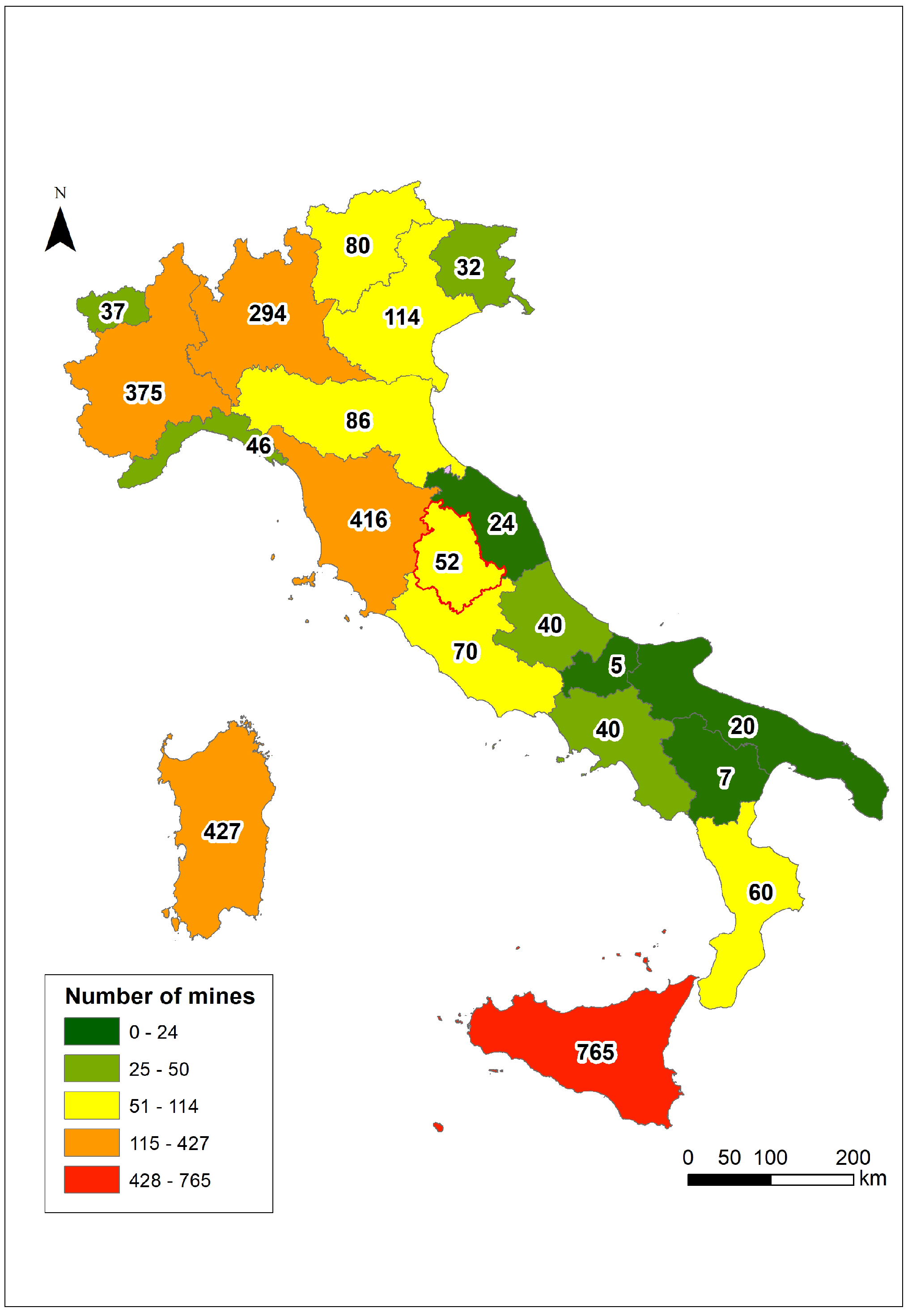
According to the Italian legislation (R.D. 1443/1927), a mine concerns the exploitation of materials of high value and strategic importance, such as ore minerals and fuel. Since 2006, ISPRA (Italian Institute for Environmental Protection and Research), which is responsible for the conservation and enhancement of the technical–scientific, historical–cultural and environmental heritage of mines, carried out (and constantly update) the “National Census of 2990 abandoned mining sites (from 1870 to 2006)” (Figure 1).
In the census, the number of sites, the extracted minerals, the activity period, the type of mining (underground, open-pit or mixed), the last dealer, the location of sites at municipal level, the current situation (abandoned, inactive or active) and the claim term, plus additional sources and references, are considered. Mining activity is widespread throughout Italy (Figure 1), and, from a geographical point of view, 74.78% of mines are present in 5 regions: Sicily (724 sites), Sardinia (427 sites), Tuscany (416 sites), Piedmont (375 sites) and Lombardy (294 sites).
At present, promotion and musealization projects interested Italian abandoned mines, producing mining museums, science and technology museums, ecomuseums and mining parks. Furthermore, thematic itineraries and mining trekking paths have been defined. This interlaces with other international initiatives and the promotion of the connected territories aimed at triggering further economic, social and touristic development. The common idea of several projects is connecting these sites along mineral routes, such as the RUMYS project [24]. The RUMYS project defines fifteen routes along a network in ten Latin American countries. The acronym derives from the Quechua word ‘Rumi’, which means ‘stone’. As a matter of fact, in this project, the stones and the minerals that had a key role in the local social development are the point of interests and the nodes of these routes.
In Italy, the ReMi project (Rete Nazionale dei Parchi e Musei Minerari Italiani - National Network of Italian Mining Parks and Museums) is the reference for a national database. Thanks to this activity, geo-mining parks have been introduced as destinations of sustainable tourism in other projects, such as the Atlas of the Soft Mobility created by the Italian Railway Network (https://experience.arcgis.com/experience/805005081da841bfb40120cd96290bcd (accessed on 17 December 2021)).
An important product of the Italian mining industry is lignite, of which one hundred and forty mines were accounted for in the national territory, mainly in Tuscany (seventy-one mines, 51%). In Italy, this fossil fuel had its maximum exploitation around 1920; then, due to the excessive cost of extraction activity and the low calorific value compared to other fuels, most of the lignite mines were closed.
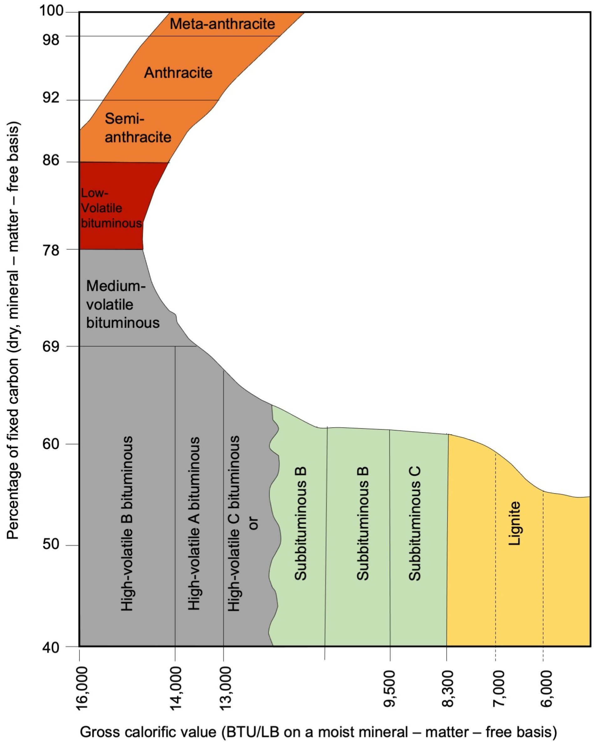
Lignite is the lowest grade term of coal composed by organic material (vegetable origin), and the carbonization stage is intermediate between peat and bituminous coal. Lignite has a carbon content of approximately 60–70% on a dry-ash-free basis that is reduced to 25–35% on an ash-received basis that encompasses both inherent moisture and mineral matter, and has a calorific value of 18.8–25.1 MJ/kg (4500–6000 kcal/kg). The humic substances (organic compounds contained in the soil) are more abundant when compared to peat and less abundant when compared to bituminous coal (Figure 2) due to different temperatures and pressures to which they have been subjected to and/or the shortest time elapsed since the beginning of organic matter decomposition [25,26].
Different types of lignite have been identified, with xyloid lignite as the most common type. It consists mainly of tree trunks with woody texture and a light brown color. Picea lignite is black, amorphous, compact and shiny, with conchoidal fracture; there is no plants evidence in the texture. It is the most valuable and can be considered as the intermediate term between bituminous coal and lignite. Peat lignite, also called brown lignite, is rich in minute plant elements (residues of herbaceous plants) cemented in a dark and compact matrix. Italian lignite of xyloid and picea types is almost completely included in Tertiary deposits, whereas the peat type is confined to Quaternary deposits [28]. The most important deposits in Italy are in Liguria, Veneto, Tuscany, Umbria and Basilicata regions.
Even if the lignite beds are close to the topographic surface and, therefore, readily exploitable, they crumble very easily and are difficult to be transported. In addition, the carbonification process is not complete in lignite and its calorific value is lower than bituminous coal. For these reasons, currently, the extraction costs do not justify its cultivation. On the contrary, in the past, lignite was extensively mined and used for steam–electric power generation in production plants close to the mining sites.
2. Lignite Deposits in Umbria Region (Central Italy)
The studied cases of this work were located in the Umbria region, central Italy. Despite its limited areal extension (8.456 km2), the Umbria region has a high geodiversity and relevant geoheritage [8] due to a complex geological history that is still well evident in the morphological and geographical setting. The region is characterized by a prevalent hilly and mountainous morphological setting with the flat areas limited to some intermontane basins [29]. The fold mountain system of the Apennine, with anticlines and synclines elongated in the N-S or NNW-SSE direction, is derived from a compressional tectonic phase (Late Miocene [30,31]). Since the Late Pliocene, a new extensional tectonic phase started, and is still active, producing Quaternary basins delimited by normal fault systems [32,33,34] that interrupt the hilly and mountainous morphological features.
The Tiberino Basin (TB) is the largest of the intermountain basins (Figure 3), with an area of approximately 1800 km2 and a shape similar to an overturned Y.
TB crosses the entire region in the longitudinal direction, with the northern section crossed by the Tiber River flowing from north to south. The TB has been active since the Late Pliocene and is limited by a segmented system of both ENE-dipping and WSW-dipping normal faults [32]. The basin is infilled by a Late Pliocene–Pleistocene continental sequence accumulated in a depositional environment where braided rivers and shallow lakes alternated and changed in time [35,36,37]. Above the sequence, the alluvial deposits of the current hydrographic network are present. The thicknesses of the Late Pliocene–Pleistocene continental sequence and of the overlaid alluvial deposits depend on the relationship between uplift and tectonic activity along the fault planes [34]. In the areas where the lacustrine and palustrine sedimentation prevails, the environment was favorable for the formation of lignite levels within clays. In most cases, lignite originated from accumulations of marsh vegetation developed in shallow water (peat bogs). Sporadically, there are remains of tree trunks, testimony of tall plants in the marshy vegetation when the level of flooding increased very slowly [25].
In particular, given the need for self-sufficiency during wartime, lignite mining was very common in Umbria from the First World War until the middle of the twentieth century. Lignite deposits are widespread and were the starting point for most of the Umbrian mining in the TB, where the deposits were recognized along the west and east basin side in the northern and southwestern sector; on the contrary, in the southeastern sector, the deposits were present only along the western margin [25].
In the past, the mining exploration was concentrated along the margins of the TB mainly because, previously, the basin was interpreted as a single large lake [38] and not, as more correctly interpreted today, as a set of interconnected river and lake environments. The mining exploration based on this wrong interpretation was oriented at the paleo-shores of the hypothetical Tiberino Lake mainly for two reasons: (1) the lignite outcrops should be more evident along the limit of the lacustrine environment, where the deposit layers should have a lower thickness, and (2) because the accumulation of plants, transported to the lake from the surrounding mountains area by the drainage network, could have accumulated in the inlets of the coast where the lake currents were less strong.
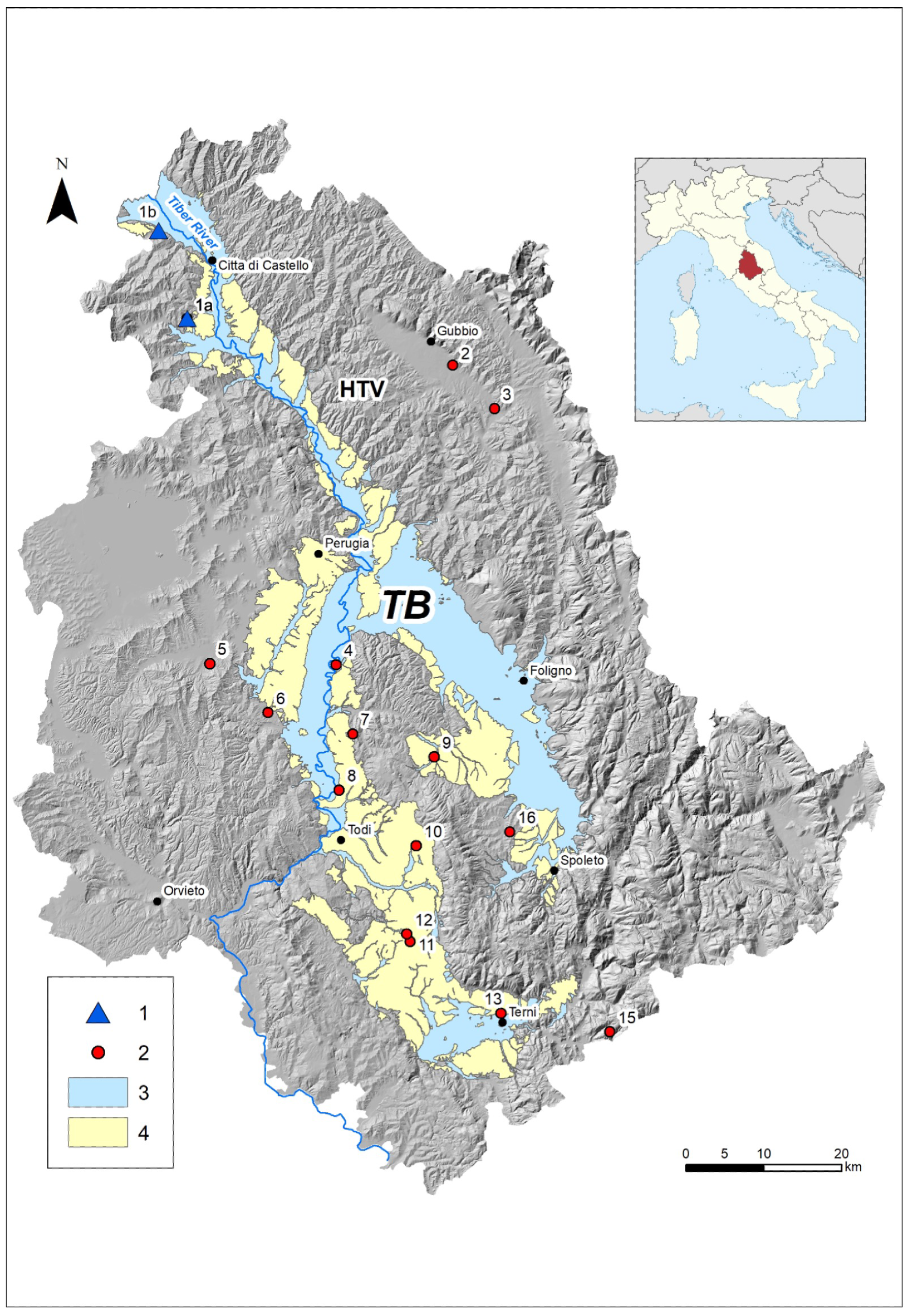
Mining activities have always been limited by the low reserve of the deposits, but it was still enough to guarantee the life of the mine for a number of years, without planning exploration activities to assess the true reserve of lignite. However, considering the census of the abandoned mines in Umbria, the lignite and, more in general, the fossil fuel were the focus of the regional mining. In a total number of 52 mining sites, 30 were devoted to fossil fuel (lignite and/or lignite xyloid and/or peat) and, among them, 20 were of lignite (Table 1, Figure 3). The remaining sites were dedicated to marl for cement.
In the northern segment of the TB, also called the High Tiber Valley (HTV), lignite has been identified in the Fighille Unit (Lower Pleistocene), which is at least 120 m thick [34,39], where clays and bluish grey marly clayey silts and light brown, grey and orange brown sandy and clayey silts prevail in one facies. The clayey silts enclose abundant plant remnants, peats and lignite levels, testifying a palustrine environment [34]. The depositional environment was a periodically flooded floodplain, with ponds, wetlands, braided rivers and alluvial fans with ephemeral channels. The climate was characterized by the alternation of dry and moist, with drained soils (calcareous nodules), or was developed under water saturation conditions (dark color) and ephemeral or highly erosive streams during heavy rains.
Some deposits have been found in the Citerna Unit (lower Early Pleistocene), superimposed to the Fighille one and with a thickness of around 200–400 m. The Citerna Unit [34,39] is characterized by two facies: (1) a coarse-grained texture with clast-supported gravels in a sandy matrix and with sandy lenses or layers; (2) a fine-grained facies associated with prevailing sandy and clay silts. The Citerna Unit refers to a braided river channel environment. We focused on the abandoned mines of the HTV, where the benches of lignite vary between 1.5 and 7 m. In detail, two little-known and only partially investigated sites were taken into account: the Caiperino and Terranera mine (Lat–Long 43.39107, 12.19578) and the Carsuga mine (Lat–Long 43.49422, 12.15480, both in Figure 3.).
3. Data and Methods
3.1. Documentary Search
Documents related to the exploitation of lignite in HTV are scarce and difficult to find. The scientific literature is not updated and has many gaps [40,41,42]; in addition, some sites have never even been listed in the official census and only historical documents prove their existence. We performed an extensive search on the scientific literature database and only a minimal documentation for Caiperino and Terranera mines was found. For this reason, the research method has some mandatory steps. The first one is the collection of multitemporal and multiscale maps and documents preserved in local archives. This activity is often time-consuming since the minor archives do not have available digital databases but only documentation in analog format. Three local historical archives (Archivio Storico Comunale e Archivio Notarile di Città di Castello, Archivio Storico Diocesano di Città di Castello, Archivio Storico del Comune di Monte Santa Maria Tiberina), a local library (Biblioteca Comunale di Città di Castello “Giosuè Carducci”) and a photo library (“Fototeca Tifernate”, photographic archive by Giuseppe Tacchini) were consulted together with two national libraries (Library of Mathematical, Physical and Geological Sciences of the University of Perugia, and “Mario Marte” Agricultural Library of the University of Perugia) and a regional and Italian digital library (MLOL—Biblioteca digitale italiana - Italian digital library). Ancient maps and documentation related to the operation of studied mine were collected.
3.2. Field Work
Once the first multitemporal and multiscale analysis on the cartographic documents and the analysis of the geological information were concluded, a field survey on the potential areas of interest was carried out. We aimed to verify and compare the actual landscape with the archival documents. Since field evidence of the mines’ existence is no longer visible, photographs, soil samples and observations were complemented by interviews with the inhabitants living in the surroundings of the extraction areas in order to build the most complete information dataset. In order to have an azimuthal vision of the landscape, in addition to the observation of multiscale and multitemporal aerial photos and considering the narrow range of the areas investigated, a survey with a drone was planned. An unmanned aerial vehicle, commonly known as drone, is a new technology for acquiring remote-sensed data used for several purposes and has been tested for geological aims, particularly for promoting areas difficult to reach or landscape contents that are hardly recognized from the ground [43,44,45]. Even if human and natural processes modified the landscape, some features are still present and may be used as ’control point’ to link the historical documents to the current landscape in order to find the location of the mining sites with the greatest possible accuracy. The observations on the field together with the drone footage allowed us to identify the reference points and to obtain a precise temporal reconstruction.
3.3. Digitalization
The obtained data were used as an input in a geographical information system (G.I.S.) in order to digitize and georeference the spatial information. The geolocalization of several multitemporal maps has some limits due to the uncertainty of localization and the approximation in the realization of maps, especially the ancient ones. Moreover, the different map scales may limit the effectiveness of the comparison [46]. Historical documents were scanned and integrated as hyperlinks to geolocalized point data. The photographic documents derived from old photographic plates were converted to digitalized images to be imported into the G.I.S. also as georeferenced images. The locations (or supposed localizations) were modeled as a point vector dataset. The area limits of the mining zones of extraction, reconstructed on the basis of historical documentation, were converted to polygonal vector data. In the same project, the topographic maps used as backdrop images had a scale of 1:10,000. In addition to historical data, a comparison with the geological structure was necessary. Geological data were extracted from the geological dataset of the Umbria Region (https://www.regione.umbria.it/paesaggio-urbanistica/cartografia-geologica (accessed on 12 November 2021)) with a scale of 1:10.0000, integrated with the new Geological Map of Italy, scale 1:50.000, N. 289 “Città di Castello” and N. 299 “Umbertide” (https://www.isprambiente.gov.it/Media/carg/289_CITTA_CASTELLO/Foglio.html (accessed on 12 November 2021); https://www.isprambiente.gov.it/Media/carg/299_UMBERTIDE/Foglio.html (accessed on 12 November 2021)).
The field survey validated the bibliographical information on the geological structure of the study areas. To increase levels of geological information, the point vector dataset edited by the Umbria Region with geognostic surveys was added (https://dati.regione.umbria.it/dataset/banca-dati-indagini-geognostiche-geofisiche (accessed on 14 March 2022)).
The geological data allow us to validate the potential sedimentary units where the lignite deposits could be present.
4. Results
4.1. The Caiperino and Terranera Mines
The Caiperino and Terranera mine area was located along the threshold area of the Aggia and Nestore rivers, both tributaries on the right of the Tiber River (Figure 3). According to the period of exploitation and the administrative boundaries, e.g., for the issuance of claim, we can consider the mining area as two separate mines: the Caiperino mine and the Terranera mine. The Caiperino mine covers the SW part of the cultivation area and is characterized by the presence of a currently hydrographic network that morphologically reshaped the area. The Terranera mine is located northeast of the previous one and has probably been exploited in more recent times.
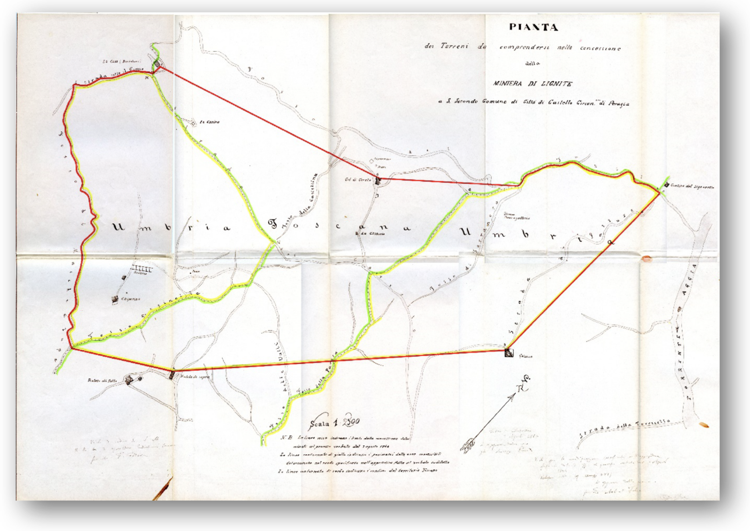
The beginning of the mining activity dates back to 1866 and lasted for 15 years; the mineralization was identified as a lignite bench that was 1.40 m thick. The area at that time was very isolated, lacking any major road to transport brown coal to Terni (the major steel production city in southern Umbria). In 1901, renewed interest in the mineralized area led to new exploration, and related documents describe the deposit in detail: “the lignite is in layers of blue marl, surmounted by a yellowish limestone sand. The strata have a dip direction equal to 55° N and a dip angle from 15° to 20°”. Attached to the report are detailed maps that show the old tunnel entrances and the location of the wells (Figure 4). In 1907, the mining activity was resumed and at least 200 tons of lignite were extracted in the Caiperino area while, in 1916, the area of Terranera produced 500 tons of lignite. Between 1917 and 1918, Austro-Hungarian prisoners present in the Upper Tiber Valley were employed in the mine. After a series of mining activities with a low income, the mine was definitively closed around 1945. There are no traces of the entrances, tracks and tunnels left.
Archival research has associated with the Caiperino mine a series of photographs dating back to 1940 that were never catalogued (http://www.archiphoto.it/new/ (accessed on 12 March 2022)). The study was carried out, on a cartographic basis, place names, interviews with local inhabitants and field work to precisely identify the morphological profiles of the places and the locations of the shooting points for each image. The photographic comparison was particularly useful for confirming the location of mine entrances; nevertheless, this process was difficult due to the presence of a dense vegetation cover that has almost completely hidden the hilly and valley profiles (Figure 5). The starting document was a 1:25,000 scale topographic map drawn up between 1925 and 1949 (and updated to 1977) that showed the symbol of a mine (no longer present in the most recent versions of the official topographical cartography).
The georeferencing procedure for the ancient map in G.I.S. returned a good match. The perimeter of the concession area shown on the map overlaps almost perfectly with the reconstructed vector perimeter from archival documents. Analogously, the places indicated on the map coincide with the locations of the current localities. Information on wells and tunnels can therefore be considered as reliable. By using the G.I.S. results, we estimate an areal extension of approximately 62 hectares in the Umbria territory and 42 hectares in Tuscany. These values match the corresponding areas derived from the archival documents.
4.2. The Carsuga Mine
The Carsuga mine (also named Pistrino, Citerna or Vingone) started the activity around 1930 and was abandoned in the post-World-War-II period. Although its exploitation was limited in time, the mine left a strong memory in the inhabitants of the immediate surroundings, but, nowadays, both memories and field evidence risk rapidly vanishing. In the current topographic maps, a locality with the toponym ’Mine’ is still present. The evidence of a lignite deposit was already present in a map attributed to Leonardo Da Vinci (RL 12676r). The mining activity began in 1934 at a level of 1.20 m thick, classified as mediocre by exploration analysis. For this reason, the extraction was soon abandoned. As for the Caiperino mine, the comparison between the actual landscape and ancient documents (maps and photographs) allowed us to observe the landscape evolution, the activities of the mine and the places where they were carried out. Similarly, the multitemporal and multiscale overlay of maps in G.I.S. evidenced the location of different components of the mining plant (Figure 6).
5. Discussion
5.1. The Value of Ghost Places in Geoheritage Promotion
Generally, the data used for valuing the geoheritage of a territory are existing landforms, outcrops or samples. Regardless of whether these objects are in situ, such as natural outcrops or features, or ex situ, such as the museum collections, what is deserving of being valued is always a real object and not an abstraction. Moreover, geosites or landscapes with a high geological value that have currently disappeared still retain the memory of an initial spatial planning and the presence of a specific geological arrangement. In other aspects of cultural heritage, different from the geological ones, the so-called ’intangible cultural heritage’ is already a well-established value that includes languages, arts, knowledge and social practices and traditional crafts. This kind of cultural heritage is essential for maintaining the cultural diversity and for perpetuating skills and knowledge over generations.
In geoheritage, the memory related to the social aspects of a territory should be considered as being as important as the physical values. If we consider the human presence and activity as a geomorphological modeling agent similar to other forces such as gravity, ice, wind, etc., we should also consider the anthropic landforms related to the geodiversity value. This is particularly true in urban areas where the urban geology and urban geomorphology take into account the anthropic processes and landforms [47,48]. Nevertheless, also in suburban areas, there could be sites, no longer existing, where the geological component was prevalent but coupled with an anthropic contribution. These sites have added geological value to cultural and social values as well, increasing the need to improve and preserve these places.
Mining sites are an excellent example of this heritage that combines abiotic natural values and the action of humans in the modeling of the territory. Abandoned and un-recovered mines are a very fragile heritage. The evolution of and adjustments in the land use are very fast in suburban areas that have already experienced the presence of man. Therefore, it is very likely that, in a few decades, the traces of this geological and social heritage can disappear completely. The conservation and outreach of these ’ghost mines’ are not easy to achieve.
5.2. Solution for the Geomining Heritage Promotion
The methodology proposed in this paper is an attempt to store, catalogue and compare historical sources for digitalizing, georeferencing and comparing the present landscape with past scenarios. Even if this technique is common in other disciplines, such as history and archaeology, in geological research, the acquisition of historical data is not so obvious. Moreover, their comparison in a G.I.S. is sometimes underestimated when compared to other quantitative approaches. The promotion of these sites can be developed in several ways. In the Italian territory, the ReMi project (Rete Nazionale dei Parchi e Musei Minerari Italiani - National Network of Italian Mining Parks and Museums) is an official database that is unique for collecting and standardizing information but not very usable for dissemination on the field. A second option could be the realization of geotouristic paths that connect abandoned sites to other points of interest, both cultural and commercial, to increase the attractiveness of the route. However, the disclosure of something that has been completely erased is not immediate. This approach can work in abandoned but still accessible and safe mines but not in areas where the traces of the mines have been completely obliterated.
An efficient alternative may be the use of digital geovisualization technologies with a 3D interactive representation of the different steps for the mining area [49,50]. By using virtual models, the no-longer-existing infrastructures around a mining area can be reproduced. In addition, the virtual models can mimic the original landscape by using digital elevation models derived from ancient maps. These techniques are quite common in urban geomorphology research, particularly for investigating the landscape evolution pre- and post-urbanization. The comparison between the actual elevation model with a DEM derived from altitude values represented in ancient maps, by exploiting the principles of map algebra analysis in G.I.S., resulted in the estimation and location of added or erased volumes of terrain [48]. Finally, if the underground network of tunnels and wells is correctly mapped, the subsurface spatial arrangement can also be modeled and visualized. All these layers can be visualized and navigable on websites using a bird’s eye perspective. However, even with this approach, it is not possible to visit the ‘lost’ mines. If the final aim is the knowledge and use of the territory, efforts should be made to attract people to the real place and interact with them for the most constructive collaboration.
We suggest, as a possible solution, a mobile application for electronic devices [45,51] in order to create an advanced mode of the fruition of naturalistic and artistic sites in rural areas through fusion between itineraries of interest and access to augmented reality content (augmented reality—AR) for the development of immersive and customized touristic experiences. One of the most important goals is integrating society into the processes of scientific research. AR is the optimal solution for visiting ghost mines that no longer exist or are no longer accessible and for displaying a 3D model of structures above and below the topographic surface using virtual tours. Our study has produced the data mining necessary to develop a digital app for the ‘ghost lignite mines’ of the Upper Tiberin Valley, particularly the historical reconstruction of the two sites of Caiperino and Carsuga mines. The next step will be to select the points of interest (PoIs) along the possible touristic paths. In the linked geodatabase, each PoI is defined by a target image that, in the case of ghost mines, is a detail or a view of the actual landscape. Framing the reference image (image recognition), the digital app will open the multimedia contents that we produced during the field work and data mining as text, drone-fly videos and 3D virtual models that the users can manipulate for an immersive and non-passive experience. With the different app utilities (i.e., ‘intelligent paths’ based on a deep neural network, links to business and cultural activities in the area), tourists may choose their own visit path and experience the visit at ghost mines to unconventionally deepen their knowledge of the territory.
6. Conclusions
Mining activity has some relevant values: from a scientific point of view, the ore minerals and the geological setting of the area is the first step. Moreover, the geomorphological evolution of the landscape due to the mining activity is another theme, particularly for the anthropic landforms or natural features modified by man. However, knowing mining activity means also discovering the history of men and women who lived at the mine. Thus, the historical, social and cultural values are equally important. Passing on the memory of what has been linked to mining activity means passing on to future generations the complete history of a territory.
The G.I.S. environment allows for the overlaying of different kinds of iconographic documents using a georeferencing procedure, and it is fundamental for limiting the no-longer-existing mining areas. As a result, the memory of the places with human presence is fundamental for the landscape evolution being preserved. Iconographic and textual documents, which would otherwise be lost, were collected in a digital format and in a georeferenced database.
Geoheritage is the joining between geological resources, landscape evolution and human presence; the proposal of a geotouristic path, connecting mines, main towns and villages with cultural value and the naturalistic routes already present in the area appears to be a good solution.
AR technology enhances the visit by correlating different information levels in space (above and under the topographic surface) and in time (the original landscape, the landscape during the mining activity and the actual landscape). The memory of local communities in rural areas is fundamental for avoiding the depopulation and abandonment of extra-urban regions. These areas are not always included in traditional touristic circuits, and cannot benefit from local economic attractors. Their economic recession can be avoided with targeted actions to strengthen geotourism. With the approach presented in this work, ’ghost mines’ can be brought back to life as cultural attractions and are embedded in their ’ecosystem’ made of both human and geological components.
Author Contributions
Conceptualization, L.M., S.N. and M.P.; methodology, L.M.; formal analysis, M.P.; investigation, M.P.; writing—original draft preparation, L.M.; writing—review and editing, L.M., S.N. and M.P.; funding acquisition, L.M. All authors have read and agreed to the published version of the manuscript.
Funding
This research was funded by he University of Perugia, Department of Physics and Geology, grant number “HUSH (Hiking in Urban Scientific Heritage) UNDERGROUND”, RicBAs2018, awarded to Laura Melelli.
Data Availability Statement
Data are available upon request from the authors.
Acknowledgments
Editors and referees are greatly acknowledged.
Conflicts of Interest
The authors declare no conflict of interest.
References
- Gordon, J.E.; Crofts, R.; Díaz-Martínez, E. Geoheritage conservation and environmental policies: Retrospect and prospect. In Geoheritage; Elsevier: Amsterdam, The Netherlands, 2018; pp. 213–235. [Google Scholar]
- Gray, M. Geodiversity: The backbone of geoheritage and geoconservation. In Assessment, Protection, and Management; Elsevier: Amsterdam, The Netherlands, 2018; pp. 13–25. [Google Scholar]
- Reynard, E.; Brilha, J. Geoheritage: Assessment, Protection, and Management; Elsevier: Amsterdam, The Netherlands, 2017. [Google Scholar]
- Zwoliński, Z.; Najwer, A.; Giardino, M. Methods for assessing geodiversity. In Geoheritage: Assessment, Protection, and Management; Elsevier: Amsterdam, The Netherlands, 2018. [Google Scholar]
- Brilha, J.; Gray, M.; Pereira, D.I.; Pereira, P. Geodiversity: An integrative review as a contribution to the sustainable management of the whole of nature. Environ. Sci. Policy 2018, 86, 19–28. [Google Scholar] [CrossRef] [Green Version]
- Coratza, P.; Reynard, E.; Zwoliński, Z. Geodiversity and geoheritage: Crossing disciplines and approaches. Geoheritage 2018, 10, 525–526. [Google Scholar] [CrossRef] [Green Version]
- Coratza, P.; Hobléa, F. The specificities of geomorphological heritage. In Geoheritage: Assessment, Protection, and Management; Elsevier: Amsterdam, The Netherlands, 2018; pp. 87–106. [Google Scholar]
- Melelli, L.; Vergari, F.; Liucci, L.; Del Monte, M. Geomorphodiversity index: Quantifying the diversity of landforms and physical landscape. Sci. Total. Environ. 2017, 584, 701–714. [Google Scholar] [CrossRef] [PubMed]
- Brilha, J. Inventory and quantitative assessment of geosites and geodiversity sites: A review. Geoheritage 2016, 8, 119–134. [Google Scholar] [CrossRef] [Green Version]
- Herrera-Franco, G.; Carrión-Mero, P.; Montalván-Burbano, N.; Caicedo-Potosí, J.; Berrezueta, E. Geoheritage and geosites: A bibliometric analysis and literature review. Geosciences 2022, 12, 169. [Google Scholar] [CrossRef]
- Migoń, P.; Pijet-Migoń, E. Viewpoint geosites—Values, conservation and management issues. Proc. Geol. Assoc. 2017, 128, 511–522. [Google Scholar] [CrossRef]
- Prosser, C.D.; Díaz-Martínez, E.; Larwood, J.G. The conservation of geosites: Principles and practice. In Geoheritage: Assessment, Protection, and Management; Elsevier: Amsterdam, The Netherlands, 2018; pp. 193–212. [Google Scholar]
- Pelfini, M.; Bollati, I. Landforms and geomorphosites ongoing changes: Concepts and implications for geoheritage promotion. Quaest. Geogr. 2014, 33, 131–143. [Google Scholar] [CrossRef] [Green Version]
- Migoń, P.; Różycka, M. When individual geosites matter less—Challenges to communicate landscape evolution of a complex morphostructure (Orlické–Bystrzyckie Mountains Block, Czechia/Poland, Central Europe). Geosciences 2021, 11, 100. [Google Scholar] [CrossRef]
- Mucivuna, V.C.; Garcia, M.d.G.M.; Reynard, E. Comparing quantitative methods on the evaluation of scientific value in geosites: Analysis from the Itatiaia National Park, Brazil. Geomorphology 2022, 396, 107988. [Google Scholar] [CrossRef]
- Carrión-Mero, P.; Loor-Oporto, O.; Andrade-Ríos, H.; Herrera-Franco, G.; Morante-Carballo, F.; Jaya-Montalvo, M.; Berrezueta, E. Quantitative and Qualitative Assessment of the “El Sexmo” Tourist Gold Mine (Zaruma, Ecuador) as A Geosite and Mining Site. Resources, 9 (3), 28. Chingombe W., 2019. Preliminary geomorphosites assessment along the panorama route of Mpumalanga province, South Africa. Geoj. Tour. Geosites 2020, 27, 1261–1270. [Google Scholar]
- Guijón, R.; Henríquez, F.; Naranjo, J.A. Geological, geographical and legal considerations for the conservation of unique iron oxide and sulphur flows at El Laco and Lastarria volcanic complexes, Central Andes, Northern Chile. Geoheritage 2011, 3, 299–315. [Google Scholar] [CrossRef]
- Ruban, D.A.; Tiess, G.; Sallam, E.S.; Ponedelnik, A.A.; Yashalova, N.N. Combined mineral and geoheritage resources related to kaolin, phosphate, and cement production in Egypt: Conceptualization, assessment, and policy implications. Sustain. Environ. Res. 2018, 28, 454–461. [Google Scholar] [CrossRef]
- Marescotti, P.; Brancucci, G.; Sasso, G.; Solimano, M.; Marin, V.; Muzio, C.; Salmona, P. Geoheritage values and environmental issues of derelict mines: Examples from the sulfide mines of Gromolo and Petronio valleys (Eastern Liguria, Italy). Minerals 2018, 8, 229. [Google Scholar] [CrossRef] [Green Version]
- Preite, M. Il patrimonio minerario e i suoi valori: Perchè e per chi i siti minerari diventano patrimonio? AIPAI 2017, XI(17), 14–21. [Google Scholar]
- Prosser, C.D. Communities, quarries and geoheritage—Making the connections. Geoheritage 2019, 11, 1277–1289. [Google Scholar] [CrossRef]
- Mata-Perelló, J.; Carrión, P.; Molina, J.; Villas-Boas, R. Geomining heritage as a tool to promote the social development of rural communities. In Geoheritage: Assessment, Protection, and Management; Elsevier: Amsterdam, The Netherlands, 2018; pp. 167–177. [Google Scholar]
- Alexandrowicz, Z.; Urban, J.; Miśkiewicz, K. Geological values of selected Polish properties of the UNESCO World Heritage List. Geoheritage 2009, 1, 43–52. [Google Scholar] [CrossRef]
- Carrión, P.; Herrera, G. Proyecto RUMYS: Rutas Minerales y Sostenibilidad. In Rutas Minerales en el Proyecto RUMYS. Un Factor Integral para el Desarrollo Sostenible de la Sociedad; Escuela Superior Politecnica del Litoral: Guayaquil, Ecuador, 2009; pp. 7–17. [Google Scholar]
- GEMINA. Ligniti e Torbe dell’Italia Continentale: Indagini Geominerarie Effettuate nel Periodo 1958–1961 dalla Geomineraria Nazionale (GEMINA) di Roma; Ilte: Torino, Italy, 1962. [Google Scholar]
- Argenti, P.; Baldanza, A.; Chiaverini, R.; Gasperini, A.; Gentili, S. Miniere di lignite in Umbria. In Quaderni del Laboratorio di Scienze della Terra, Pietre e Terre nel Lavoro Dell’uomo; Mattioli, B., Ed.; Comune di Spoleto: Spoleto, Italy, 2006; pp. 2–3. [Google Scholar]
- Trumbull, J.; Barnes, F.F. Coal Fields of the United States; Technical Report; US Geological Survey: Reston, VA, USA, 1960. [Google Scholar]
- Bucci, F.; Santangelo, M.; Fongo, L.; Alvioli, M.; Cardinali, M.; Melelli, L.; Marchesini, I. A new digital lithological map of Italy at the 1: 100 000 scale for geomechanical modelling. Earth Syst. Sci. Data 2022, 14, 4129–4151. [Google Scholar] [CrossRef]
- Della Seta, M.; Melelli, L.; Pambianchi, G. Relief, intermontane basins and civilization in the umbria-marche apennines: Origin and life by geological consent. In Landscapes and Landforms of Italy; Springer: Cham, Swizerland, 2017; pp. 317–326. [Google Scholar]
- Barchi, M.R.; Beltrando, M. The Neogene-Quaternary evolution of the Northern Apennines: Crustal structure, style of deformation and seismicity. J. Virtual Explor. 2010, 36, 11. [Google Scholar] [CrossRef]
- Barchi, M.R.; Ciaccio, M.G. Seismic images of an extensional basin, generated at the hangingwall of a low-angle normal fault: The case of the Sansepolcro basin (Central Italy). Tectonophysics 2009, 479, 285–293. [Google Scholar] [CrossRef]
- Famiani, D.; Brunori, C.A.; Pizzimenti, L.; Cara, F.; Caciagli, M.; Melelli, L.; Mirabella, F.; Barchi, M.R. Geophysical reconstruction of buried geological features and site effects estimation of the Middle Valle Umbra basin (central Italy). Eng. Geol. 2020, 269, 105543. [Google Scholar] [CrossRef]
- Melelli, L.; Pucci, S.; Saccucci, L.; Mirabella, F.; Pazzaglia, F.; Barchi, M. Morphotectonics of the Upper Tiber Valley (Northern Apennines, Italy) through quantitative analysis of drainage and landforms. Rend. Lincei 2014, 25, 129–138. [Google Scholar] [CrossRef]
- Pucci, S.; Mirabella, F.; Pazzaglia, F.; Barchi, M.; Melelli, L.; Tuccimei, P.; Soligo, M.; Saccucci, L. Interaction between regional and local tectonic forcing along a complex Quaternary extensional basin: Upper Tiber Valley, Northern Apennines, Italy. Quat. Sci. Rev. 2014, 102, 111–132. [Google Scholar] [CrossRef]
- Barchi, M.; Brozzetti, F.; Lavecchia, G. Analisi strutturale e geometrica dei bacini della media Valle del Tevere e della Valle Umbra. Boll. Della Soc. Geol. Ital. 1991, 110, 65–76. [Google Scholar]
- Basilici, G. Sedimentary facies in an extensional and deep-lacustrine depositional system: The Pliocene Tiberino Basin, Central Italy. Sediment. Geol. 1997, 109, 73–94. [Google Scholar] [CrossRef]
- Bucci, F.; Mirabella, F.; Santangelo, M.; Cardinali, M.; Guzzetti, F. Photo-geology of the Montefalco Quaternary Basin, Umbria, Central Italy. J. Maps 2016, 12, 314–322. [Google Scholar] [CrossRef] [Green Version]
- Lotti, B. Descrizione Geologica dell’Umbria; Istituto Poligrafico e Zecca dello Stato: Rome, Italy, 1926. [Google Scholar]
- ISPRA. Città Di Castello, Sheet 289. In Carta Geologica d’Italia, 1:50,000; ISPRA: Rome, Italy, 2021. [Google Scholar]
- Baldanza, A.; Spirito, A. Dalla classificazione alla musealizzazione: Allestimento di un’esposizione di reperti vegetali fossili presso il “Centro Studi sul Quaternario”(CeSQ) di Sansepolcro. In Museologia Scientifica Nuova Serie; Associazione Nazionale Musei Scientifici: Florence, Italy, 2010; Volume 41, pp. 130–136. [Google Scholar]
- Camporeale, G. Gli Etruschi: Storia e Civiltà; UTET: Torino, Italy; p. 648. Available online: https://www.utetlibri.it/libri/gli-etruschi-storia-e-civilta/ (accessed on 2 July 2023).
- Cattuto, C.; Cencetti, C.; Fisauli, M.; Gregori, L. I bacini pleistocenici di Anghiari e Sansepolcro nell’alta valle del Tevere. Il Quat. 1995, 8, 119–128. [Google Scholar]
- Bonali, F.L.; Russo, E.; Vitello, F.; Antoniou, V.; Marchese, F.; Fallati, L.; Bracchi, V.; Corti, N.; Savini, A.; Whitworth, M.; et al. How academics and the public experienced immersive virtual reality for geo-education. Geosciences 2021, 12, 9. [Google Scholar] [CrossRef]
- Janeras, M.; Roca, J.; Gili, J.A.; Pedraza, O.; Magnusson, G.; Núñez-Andrés, M.A.; Franklin, K. Using Mixed Reality for the Visualization and Dissemination of Complex 3D Models in Geosciences—Application to the Montserrat Massif (Spain). Geosciences 2022, 12, 370. [Google Scholar] [CrossRef]
- Melelli, L. “Perugia upside-down”: A multimedia exhibition in Umbria (Central Italy) for improving geoheritage and geotourism in urban areas. Resources 2019, 8, 148. [Google Scholar] [CrossRef] [Green Version]
- Luft, J.; Schiewe, J. Automatic content-based georeferencing of historical topographic maps. Trans. GIS 2021, 25, 2888–2906. [Google Scholar] [CrossRef]
- Brandolini, P.; Cappadonia, C.; Luberti, G.M.; Donadio, C.; Stamatopoulos, L.; Di Maggio, C.; Faccini, F.; Stanislao, C.; Vergari, F.; Paliaga, G.; et al. Geomorphology of the Anthropocene in Mediterranean urban areas. Prog. Phys. Geogr. Earth Environ. 2020, 44, 461–494. [Google Scholar] [CrossRef]
- Vergari, F.; Pica, A.; Brandolini, P.; Melelli, L.; Del Monte, M. Geomorphological classification of the landscape in urban areas. Hints from some study cases in Italy. Rend. Online Della Soc. Geol. Ital. 2022, 57, 33–39. [Google Scholar] [CrossRef]
- Cayla, N.; Martin, S. Digital geovisualisation technologies applied to geoheritage management. In Geoheritage: Assessment, Protection, and Management; Elsevier: Amsterdam, The Netherlands, 2018; pp. 289–303. [Google Scholar]
- Jiang, W.; Zhang, Y. Application of 3D visualization in landscape design teaching. Int. J. Emerg. Technol. Learn. 2019, 14, 53. [Google Scholar] [CrossRef] [Green Version]
- Melelli, L.; Silvani, F.; Ercoli, M.; Pauselli, C.; Tosi, G.; Radicioni, F. Urban geology for the enhancement of the hypogean geosites: The Perugia underground (Central Italy). Geoheritage 2021, 13, 18. [Google Scholar] [CrossRef]
Figure 1.
Number of mines for region in Italy recorded for the period from 1870 to 2006 (data from https://www.isprambiente.gov.it/files/miniere/i–siti–minerari–italiani–1870–2006.pdf).
Figure 1.
Number of mines for region in Italy recorded for the period from 1870 to 2006 (data from https://www.isprambiente.gov.it/files/miniere/i–siti–minerari–italiani–1870–2006.pdf).

Figure 2.
Scheme showing classification of coals by rank in the United States as a measure of the progressive alteration from lignite to anthracite. Modified from [27].
Figure 2.
Scheme showing classification of coals by rank in the United States as a measure of the progressive alteration from lignite to anthracite. Modified from [27].

Figure 3.
Abandoned mines in Umbria region and the Tiberino Basin. (1) Investigated sites: 1a Caiperino–Terranera; 1b Carsuga. (2) Known mines: 2 Padule; 3 Branca Galvana; 4 Deruta; 5 Pietrafitta; 6 Morcella; 7 Collazzone; 8 Ilci; 9 Bastardo; 10 Massa Martana; 11 Monte Castrilli; 12 Collesecco; 13 Colle dell’Oro; 14 Bonacquisto; 15 Morgnano; 16 S. Angelo in Mercole. (3) Alluvial deposits in the Tiberino Basin (Holocene). (4) Fluvial and lacustrine complex (Pliocene and Pleistocene).

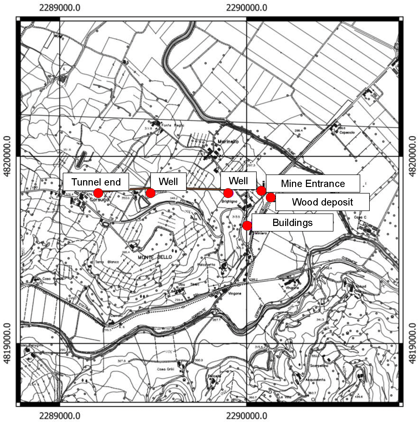
Figure 4.
The location map of the different components of the mining area for the Carsuga mine.

Figure 5.
Comparison between a historical photo (archive G. Tacchini, 1940) and the current landscape in the Caiperino mine. The colored lines highlight the points of reference identified for the comparison between the two images and for defining the placement of the historical photo.
Figure 5.
Comparison between a historical photo (archive G. Tacchini, 1940) and the current landscape in the Caiperino mine. The colored lines highlight the points of reference identified for the comparison between the two images and for defining the placement of the historical photo.

Figure 6.
Comparison between a historical photo (archive G. Tacchini, 1940) and the current landscape in the Carsuga mine. The red circle highlights the same reference place identified in both images. In the historical photo, the wood storage area for tunnel covers is present.
Figure 6.
Comparison between a historical photo (archive G. Tacchini, 1940) and the current landscape in the Carsuga mine. The red circle highlights the same reference place identified in both images. In the historical photo, the wood storage area for tunnel covers is present.


Table 1.
Number of extraction sites in Umbria divided by type of mineral.
| Extracted Minerals | Number of Sites |
|---|---|
| Common lignite | 20 |
| Marl for cement | 17 |
| Xyloid lignite | 10 |
| Clay | 2 |
| Leucite | 1 |
| Iron | 1 |
| Peat | 1 |
Disclaimer/Publisher’s Note: The statements, opinions and data contained in all publications are solely those of the individual author(s) and contributor(s) and not of MDPI and/or the editor(s). MDPI and/or the editor(s) disclaim responsibility for any injury to people or property resulting from any ideas, methods, instructions or products referred to in the content. |
© 2023 by the authors. Licensee MDPI, Basel, Switzerland. This article is an open access article distributed under the terms and conditions of the Creative Commons Attribution (CC BY) license (https://creativecommons.org/licenses/by/4.0/).
Share and Cite
MDPI and ACS Style
Melelli, L.; Palombo, M.; Nazzareni, S. Ghost Mines for Geoheritage Enhancement in the Umbria Region (Central Italy). Geosciences 2023, 13, 208. https://doi.org/10.3390/geosciences13070208
AMA Style
Melelli L, Palombo M, Nazzareni S. Ghost Mines for Geoheritage Enhancement in the Umbria Region (Central Italy). Geosciences. 2023; 13(7):208. https://doi.org/10.3390/geosciences13070208
Chicago/Turabian StyleMelelli, Laura, Massimo Palombo, and Sabrina Nazzareni. 2023. "Ghost Mines for Geoheritage Enhancement in the Umbria Region (Central Italy)" Geosciences 13, no. 7: 208. https://doi.org/10.3390/geosciences13070208
Note that from the first issue of 2016, this journal uses article numbers instead of page numbers. See further details here.