
Lifecycle of an Intermontane Plio-Pleistocene Fluvial Valley of the Northern Apennines: From Marine-Driven Incision to Tectonic Segmentation and Infill

 , ,
, ,  ,
,  ,
,
Abstract
:1. Introduction

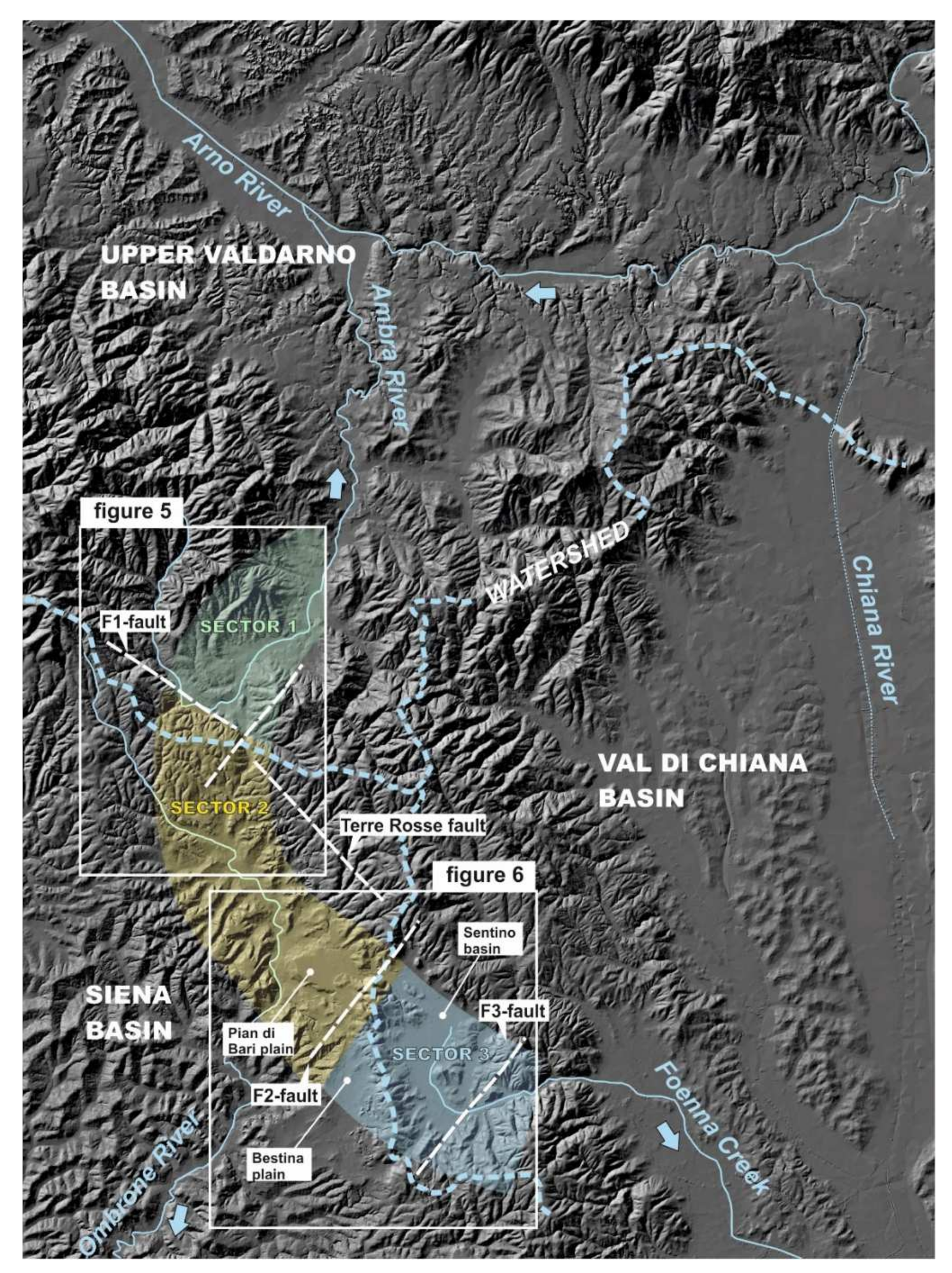
2. Geological Setting

3. Materials and Methods

4. Results
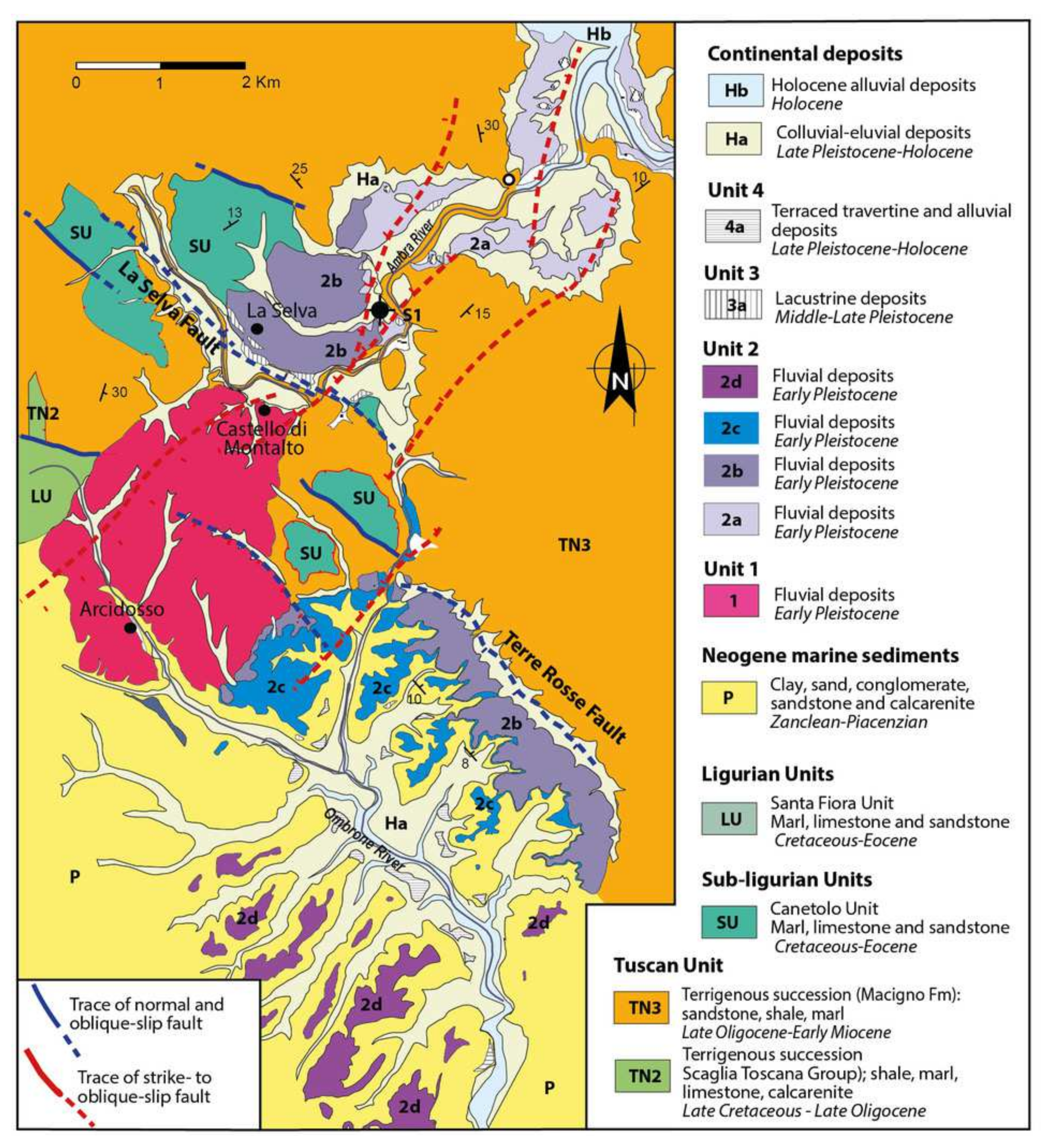
4.1. Structural Features
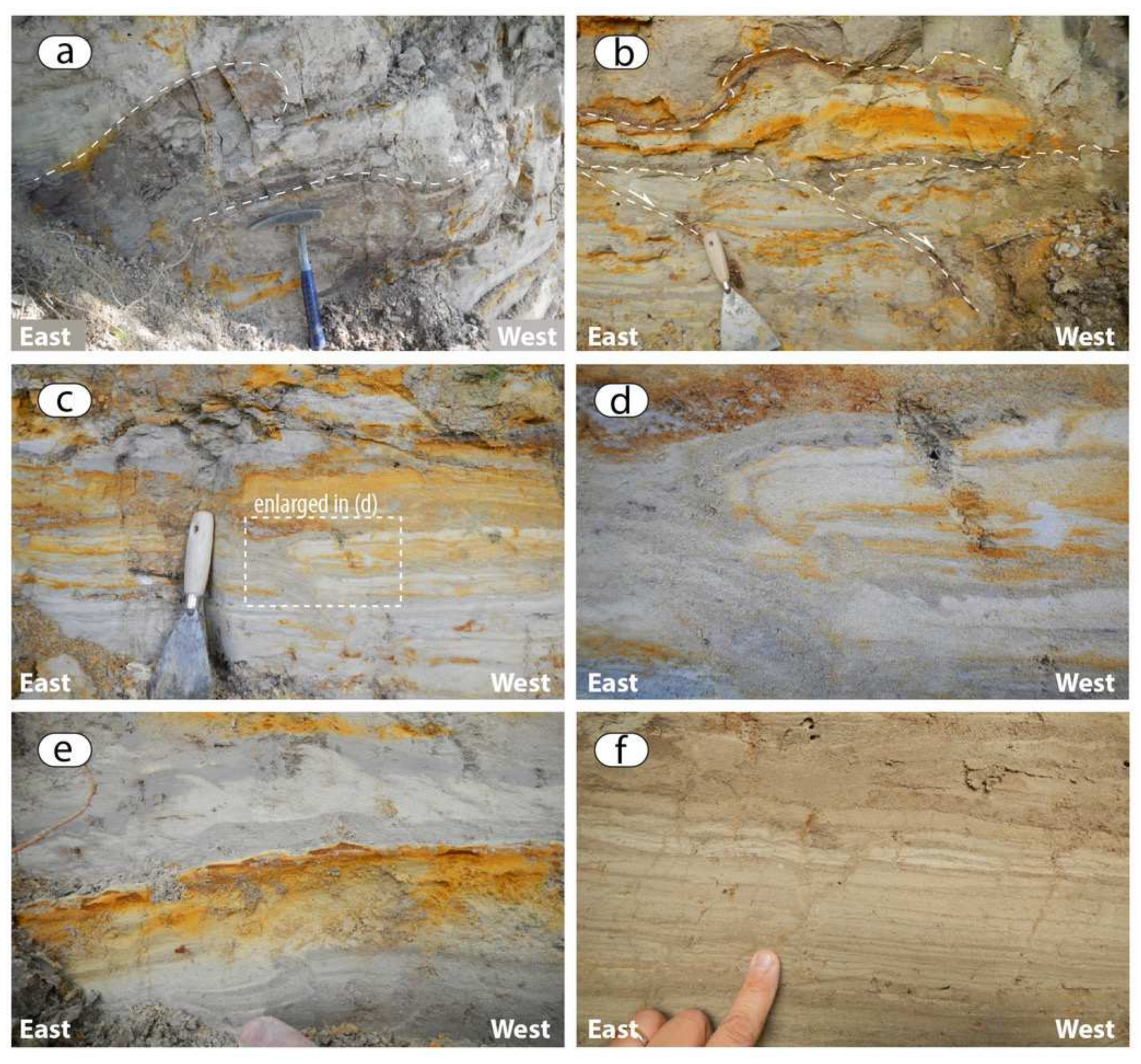
4.2. Stratigraphy
4.2.1. Unit 1
Sector 1
Sector 2
Sector 3
Palaeoflow Data
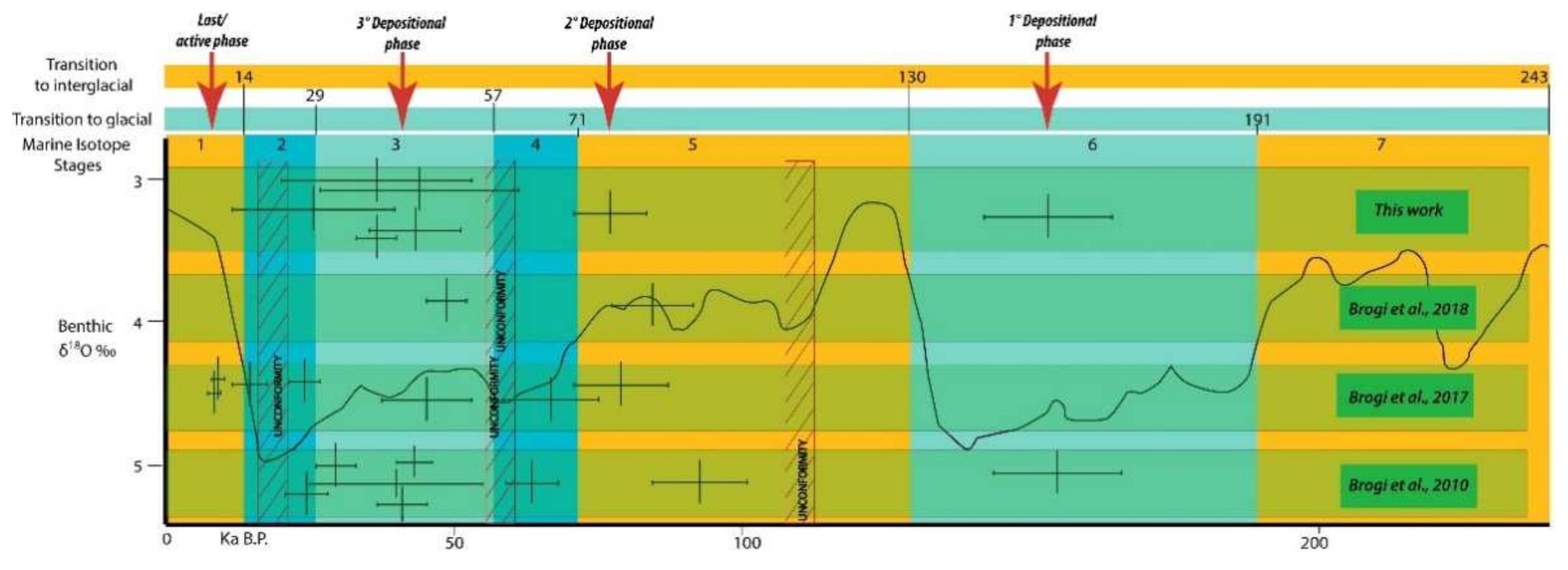
Age
4.2.2. Unit 2
Sector 1
Sector 2
Sector 3
Palaeoflow Data
Age
4.2.3. Unit 3
Sector 1
Sector 2
Sector 3
Palaeoflow Data
Age
4.2.4. Unit 4
Sector 1
Sector 2
Sector 3
Palaeoflow Data
Age
5. Discussion
5.1. Palaeo-Drainage Evolution and Age
5.2. Lifecycle of an Intermontane Fluvial Valley
6. Conclusions
- -
- Forcings causing incision and filling of a valley do not have to be genetically related. Although the study valley was cut as consequence of a relative sea-level fall, alluvial aggradation valley was not driven by a relative sea-level rise but resulted from an increase in sediment supply and a tectonic-driven sediment trapping within the valley.
- -
- Tectonic segmentation of a valley can cause a wide spectrum of depositional environments within the major valley trunk. The occurrence of fluvial, lacustrine and travertines deposits in the studied valley-fill succession account for this process and highlight that such a large spatial variability of sedimentary facies can hinder detection of ancient valleys in the rock record.
- -
- The wide spectrum of deposits filling the tectonically-segmented valley is an archive for tectono-climatic events. Specifically, it arises that the inner sector of Norther Apennines was affected by a significant tectonic activity during Pleistocene-Holocene times, in response to a transtensive stress field.
Author Contributions
Funding
Data Availability Statement
Acknowledgments
Conflicts of Interest
References
- Zaitlin, B.A.; Dalrymple, R.W.; Boyd, R. The Stratigraphic Organization of Incised-Valley Systems Associated with Relative Sea-Level Change. In Incised-Valley Systems: Origin and Sedimentary Sequences; Dalrymple, R., Boyd, R., Zaitlin, B.A., Eds.; SEPM Society for Sedimentary Geology: Tulsa, OK, USA, 1994; Volume SEPM SP 51, pp. 45–60. ISBN 9781565760905. [Google Scholar]
- Corner, G.D. A Transgressive-Regressive Model of Fjord-Valley Fill: Stratigraphy, Facies and Depositional Controls. In Incised Valleys in Time and Space; Dalrymple, R., Leckie, D., Tillman, R., Eds.; SEPM Society for Sedimentary Geology: Tulsa, OK, USA, 2006; Volume SEPM SP 85, pp. 161–178. ISBN 1565761227. [Google Scholar]
- Simms, A.R.; Anderson, J.B.; Taha, Z.P.; Rodriguez, A.B. Overfilled versus Underfilled Incised Valleys: Examples from the Quaternary Gulf of Mexico. In Incised Valleys in Time and Space; Dalrymple, R., Leckie, D., Tillman, R., Eds.; SEPM Society for Sedimentary Geology: Tulsa, OK, USA, 2006; Volume SEPM SP 85, pp. 117–139. ISBN 1565761227. [Google Scholar]
- Deibert, J.E.; Camilleri, P.A. Sedimentologic and tectonic origin of an incised-valley-fill sequence along an extensional marginal-lacustrine system in the Basin and Range province, United States: Implications for predictive models of the location of incised valleys. Am. Assoc. Pet. Geol. Bull. 2006, 90, 209–235. [Google Scholar] [CrossRef]
- Garrison, J.R., Jr.; van den Bergh, T.C.V. Effects of Sedimentation Rate, Rate of Relative Rise in Sea Level, and Duration of Sea-Level Cycle on the Filling of Incised Valleys: Examples of Filled and overfilled Incised Valleys From the Upper Ferron Sandstone, Last Chance Delta, East-Central Utah. In Incised Valleys in Time and Space; Dalrymple, R., Leckie, D., Tillman, R., Eds.; Special Publications of SEPM: Tulsa, OK, USA, 2006; Volume SEPM SP 85, pp. 239–279. [Google Scholar]
- Plink-Björklund, P.; Steel, R.J. Incised Valleys On An Eocene Coastal Plain And Shelf, Spitsbergen—Part of A Linked Shelf–Slope System. In Incised Valleys in Time and Space; Dalrymple, R., Leckie, D., Tillman, R., Eds.; SEPM Society for Sedimentary Geology: Tulsa, OK, USA, 2006; Volume SEPM SP 85, pp. 281–307. ISBN 1565761227. [Google Scholar]
- Gobo, K.; Ghinassi, M.; Nemec, W.; Sjursen, E. Development of an incised valley-fill at an evolving rift margin: Pleistocene eustasy and tectonics on the southern side of the Gulf of Corinth, Greece. Sedimentology 2014, 61, 1086–1119. [Google Scholar] [CrossRef] [Green Version]
- Boyd, R.; Dalrymple, R.W.; Zaitlin, B.A. Estuarine and Incised-Valley Facies Models. In Facies Models Revisited; Walker, R.G., Posamentier, H., Eds.; SEPM Society for Sedimentary Geology: Tulsa, OK, USA, 2006; Volume SEPM SP 84, pp. 171–235. ISBN 9781565763302. [Google Scholar]
- Blum, M.D.; Törnqvist, T.E. Fluvial responses to climate and sea-level change: A review and look forward. Sedimentology 2000, 47, 2–48. [Google Scholar] [CrossRef]
- Holbrook, J. Origin, genetic interrelationships, and stratigraphy over the continuum of fluvial channel-form bounding surfaces: An illustration from middle Cretaceous strata, Southeastern Colorado. Sediment. Geol. 2001, 144, 179–222. [Google Scholar] [CrossRef]
- Vincent, S.J. The Sis palaeovalley: A record of proximal fluvial sedimentation and drainage basin development in response to Pyrenean mountain building. Sedimentology 2001, 48, 1235–1276. [Google Scholar] [CrossRef]
- Gibling, M.R.; Fielding, C.R.; Sinha, R. Alluvial Valleys and Alluvial Sequences:Towards a Geomorphic Assessment. In From River to Rock Record: The Preservation of Fluvial Sediments and Their Subsequent Interpretation; Davidson, S.K., Leleu, S., North, C.P., Eds.; SEPM Society for Sedimentary Geology: Tulsa, OK, USA, 2011; Volume SEPM SP 97, pp. 423–447. ISBN 9781565763050. [Google Scholar]
- Hain, M.P.; Strecker, M.R.; Bookhagen, B.; Alonso, R.N.; Pingel, H.; Schmitt, A.K. Neogene to Quaternary broken foreland formation and sedimentation dynamics in the Andes of NW Argentina (25° S). Tectonics 2011, 30, 1–27. [Google Scholar] [CrossRef]
- Mey, J.; Scherler, D.; Zeilinger, G.; Strecker, M.R. Estimating the fill thickness and bedrock topography in intermontane valleys using artificial neural networks. J. Geophys. Res. Earth Surf. 2015, 120, 1301–1320. [Google Scholar] [CrossRef] [Green Version]
- Wang, P.; Scherler, D.; Liu-Zeng, J.; Mey, J.; Avouac, J.-P.; Zhang, Y.; Shi, D. Tectonic control of Yarlung Tsangpo Gorge revealed by a buried canyon in Southern Tibet. Science 2014, 346, 978–981. [Google Scholar] [CrossRef] [Green Version]
- Martini, I.P.; Sagri, M. Tectono-sedimentary characteristics of Late Miocene-Quaternary extensional basins of the Northern Apennines, Italy. Earth-Sci. Rev. 1993, 34, 197–233. [Google Scholar] [CrossRef]
- Cosentino, D.; Asti, R.; Nocentini, M.; Gliozzi, E.; Kotsakis, T.; Mattei, M.; Esu, D.; Spadi, M.; Tallini, M.; Cifelli, F.; et al. New insights into the onset and evolution of the central Apennine extensional intermontane basins based on the tectonically active L’Aquila Basin (central Italy). Bull. Geol. Soc. Am. 2017, 129, 1314–1336. [Google Scholar] [CrossRef] [Green Version]
- Bartolini, C.; D’Agostino, N.; Dramis, F. Topography, exhumation, and drainage network evolution of the Apennines. Episodes 2003, 26, 212–216. [Google Scholar] [CrossRef]
- D’Agostino, N.; Jackson, J.A.; Dramis, F.; Funiciello, R. Interactions between mantle upwelling, drainage evolution and active normal faulting: An example from the Central Appennines (Italy). Geophys. J. Int. 2001, 147, 475–497. [Google Scholar] [CrossRef]
- Piacentini, T.; Miccadei, E. The role of drainage systems and intermontane basins in the Quaternary landscape of the Central Apennines chain (Italy). Rend. Lincei 2014, 25, 139–150. [Google Scholar] [CrossRef]
- Bartolini, C.; Pranzini, G. Plio-Quaternary evolution of the Arno basin drainage. Z. Geomorphol. Suppl. Stuttg. 1981, 40, 77–91. [Google Scholar]
- Bianchi, V.; Ghinassi, M.; Aldinucci, M.; Boaga, J.; Brogi, A.; Deiana, R. Tectonically driven deposition and landscape evolution within upland incised valleys: Ambra Valley fill, Pliocene-Pleistocene, Tuscany, Italy. Sedimentology 2015, 62, 897–927. [Google Scholar] [CrossRef]
- Bianchi, V.; Salles, T.; Ghinassi, M.; Billi, P.; Dallanave, E.; Duclaux, G. Numerical modeling of tectonically driven river dynamics and deposition in an upland incised valley. Geomorphology 2015, 241, 353–370. [Google Scholar] [CrossRef]
- Liotta, D.; Cernobori, L.; Nicolicl, R. Restricted rifting and its coexistence with compressional structures: Results from the CROP 3 traverse (Northern Apennines, Italy). Terra Nova 1998, 10, 16–20. [Google Scholar] [CrossRef]
- Carmignani, L.; Decandia, F.A.; Disperati, L.; Fantozzi, P.L.; Kligfield, R.; Lazzarotto, A.; Liotta, D.; Meccheri, M. Inner Northern Apennines. In Anatomy of an Orogen: The Apennines and Adjacent Mediterranean Basins; Vai, G.B., Martini, I.P., Eds.; Springer: Dordrecht, The Netherlands, 2001; pp. 197–213. ISBN 978-94-015-9829-3. [Google Scholar]
- Carmignani, L.; Decandia, F.A.; Dispera, L.; Fantozzi, P.L.; Lazzarotto, A.; Oggiano, G.; Angioj, V.C.M. Relationships between the Tertiary structural evolution of the Sardinia-Corsica-Provençal Domain and the Northern Apennines. Terra Nova 1995, 7, 128–137. [Google Scholar] [CrossRef]
- Nalin, R.; Ghinassi, M.; Foresi, L.M.; Dallanave, E. Carbonate deposition in restricted basins: A Pliocene case study from the central Mediterranean (Northwestern Apennines), Italy. J. Sediment. Res. 2016, 86, 236–267. [Google Scholar] [CrossRef]
- Brogi, A.; Liotta, D. Highly extended terrains, lateral segmentation of the substratum, and basin development: The middle-late Miocene Radicondoli Basin (inner northern Apennines, Italy). Tectonics 2008, 27, 1–20. [Google Scholar] [CrossRef]
- Barchi, M.R. The Neogene-Quaternary evolution of the Northern Apennines: Crustal structure, style of deformation and seismicity. J. Virtual Explor. 2010, 36. [Google Scholar] [CrossRef]
- Sagri, M.; Magi, M. Il Bacino del Valdarno Superiore. Soc. Geol. Ital. L’Appennino Settentr. Guid. Alle Escursioni Post-Congr. 1992, 201, 226. [Google Scholar]
- Albianelli, A.; Bertini, A.; Magi, M.; Napoleone, G.; Sagri, M. Il bacino Plio-Pleistocenico del Valdarno Superiore: Eventi deposizionali, paleomagnetici e paleoclimatici. Quaternario 1995, 8, 11–18. [Google Scholar]
- Ghinassi, M.; Magi, M. Variazioni climatiche, tettonica e sedimentazione al passaggio Pliocene medio-Pliocene superiore nel bacino del Valdarno Superiore (Appennino Settentrionale). Ital. J. Geosci. 2004, 123, 301–310. [Google Scholar]
- Fidolini, F.; Ghinassi, M.; Magi, M.; Papini, M.; Sagri, M. The Plio-Pleistocene fluvio-lacustrine Upper Valdarno Basin (Central Italy): Stratigraphy and Basin fill evolution. Ital. J. Geosci. 2013, 132, 13–32. [Google Scholar] [CrossRef]
- Rook, L.; Croitor, R.; Delfino, M.; Ferretti, M.P.; Gallai, G.; Pavia, M. The Upper Valdarno Plio-Pleistocene vertebrate record: An historical overview, with notes on palaeobiology and stratigraphic significance of some important taxa. Ital. J. Geosci. 2013, 132, 104–125. [Google Scholar] [CrossRef]
- Billi, P.; Magi, M.; Sagri, M. Coarse-Grained Low-Sinuosity River Deposits: Example from Plio-Pleistocene Valdarno Basin, Italy. In Recent Developments in Fluvial Sedimentolology; SEPM Society for Sedimentary Geology: Tulsa, OK, USA, 1987; pp. 197–203. [Google Scholar]
- Fidolini, F.; Ghinassi, M.; Aldinucci, M.; Billi, P.; Boaga, J.; Deiana, R.; Brivio, L. Fault-sourced alluvial fans and their interaction with axial fluvial drainage: An example from the Plio-Pleistocene Upper Valdarno Basin (Tuscany, Italy). Sediment. Geol. 2013, 289, 19–39. [Google Scholar] [CrossRef]
- Bonini, M.; Sani, F. Extension and compression in the Northern Apennines (Italy) hinterland: Evidence from the late Miocene-Pliocene Siena-Radicofani Basin and relations with basement structures. Tectonics 2002, 21, 1–35. [Google Scholar] [CrossRef] [Green Version]
- Brogi, A. Bowl-shaped basin related to low-angle detachment during continental extension: The case of the controversial Neogene Siena Basin (central Italy, Northern Apennines). Tectonophysics 2011, 499, 54–76. [Google Scholar] [CrossRef]
- Martini, I.; Aldinucci, M.; Foresi, L.M.; Mazzei, R.; Sandrelli, F. Geological map of the Pliocene succession of the Northern Siena Basin (Tuscany, Italy). J. Maps 2011, 7, 193–205. [Google Scholar] [CrossRef]
- Martini, I.; Arragoni, S.; Aldinucci, M.; Foresi, L.M.; Bambini, A.M.; Sandrelli, F. Detection of detached forced-regressive nearshore wedges: A case study from the central-southern Siena Basin (Northern Apennines, Italy). Int. J. Earth Sci. 2013, 102, 1467–1489. [Google Scholar] [CrossRef]
- Martini, I.; Aldinucci, M. Sedimentation and basin-fill history of the pliocene succession exposed in the Northern Siena-Radicofani Basin (Tuscany, Italy): A sequence-stratigraphic approach. Riv. Ital. Paleontol. Stratigr. 2017, 123, 407–432. [Google Scholar] [CrossRef]
- Baldanza, A.; Bizzarri, R.; Famiani, F.; Garassino, A.; Hyžný, M.; Pasini, G. The bathyal decapod crustacean community from the Poggio i Sodi quarries (Siena Basin, Tuscany, Italy). Bol. Soc. Geol. Mex. 2013, 65, 335–353. [Google Scholar] [CrossRef]
- Barchi, M.; Minelli, G.; Magnani, B.; Mazzotti, A. Line CROP 03: Northern Apennines. Mem. Descr. Cart. Geol. d’It. 2003, LXII, 127–136. [Google Scholar]
- Bizzarri, R.; Baldanza, A. Integrated stratigraphy of the marine Early Pleistocene in Umbria. Geosciences 2020, 10, 371. [Google Scholar] [CrossRef]
- Aruta, G.; Borgia, A.; Bruni, P.; Cecchi, G.; Cipriani, N.; Tredici, Y. Pliocene and Pleistocene unconformity bounded stratigraphic units (UBSU) in Val di Chiana. In The “Regione Toscana” Project of Geological Mapping: Case Histories and Data Acquisition; Morini, D., Bruni, P., Eds.; Tipografia Martinelli: Bagno a Ripoli, Italy, 2004; pp. 133–136. [Google Scholar]
- Rook, L.; Martínez-Navarro, B. Villafranchian: The long story of a Plio-Pleistocene European large mammal biochronologic unit. Quat. Int. 2010, 219, 134–144. [Google Scholar] [CrossRef]
- Brogi, A. Late evolution of the inner Northern Apennines from the structure of the Monti del Chianti-Monte Cetona ridge (Tuscany, Italy). J. Struct. Geol. 2020, 141, 104205. [Google Scholar] [CrossRef]
- Liotta, D. Analisi del settore centro-meridionale del bacino pliocenico di Radicofani (Toscana meridionale). Boll. Soc. Geol. Ital. 1996, 115, 115–143. [Google Scholar]
- Pascucci, V.; Martini, I.P.; Sagri, M.; Sandrelli, F. Effects of Transverse Structural Lineaments on the Neogene–Quaternary Basins of Tuscany (Inner Northern Apennines, Italy). In Sedimentary Processes, Environments and Basins: A Tribute to Peter Friend; Nichols, G., Williams, E., Paola, C., Eds.; John Wiley & Sons: Hoboken, NJ, USA, 2007; pp. 155–182. ISBN 9781405179225. [Google Scholar]
- Bambini, A.M.; Brogi, A.; Cornamusini, G.; Costantini, A.; Foresi, L.M.; Lazzarotto, A. Geologia dell’area di Rapolano Terme in provincia di Siena (Appennino Settentrionale). Ital. J. Geosci. 2010, 129, 457–495. [Google Scholar] [CrossRef]
- Brogi, A.; Capezzuoli, E.; Aqué, R.; Branca, M.; Voltaggio, M. Studying travertines for neotectonics investigations: Middle-Late Pleistocene syn-tectonic travertine deposition at Serre di Rapolano (Northern Apennines, Italy). Int. J. Earth Sci. 2010, 99, 1383–1398. [Google Scholar] [CrossRef]
- Brogi, A.; Capezzuoli, E.; Martini, I.; Picozzi, M.; Sandrelli, F. Late quaternary tectonics in the inner Northern apennines (Siena Basin, southern Tuscany, Italy) and their seismotectonic implication. J. Geodyn. 2014, 76, 25–45. [Google Scholar] [CrossRef]
- Brogi, A.; Capezzuoli, E.; Kele, S.; Baykara, M.O.; Shen, C.C. Key travertine tectofacies for neotectonics and palaeoseismicity reconstruction: Effects of hydrothermal overpressured fluid injection. J. Geol. Soc. 2017, 174, 679–699. [Google Scholar] [CrossRef]
- Brogi, A.; Capezzuoli, E.; Moretti, M.; Olvera-García, E.; Matera, P.F.; Garduno-Monroy, V.H.; Mancini, A. Earthquake-triggered soft-sediment deformation structures (seismites) in travertine deposits. Tectonophysics 2018, 745, 349–365. [Google Scholar] [CrossRef]
- Brogi, A. Faults linkage, damage rocks and hydrothermal fluid circulation: Tectonic interpretation of the Rapolano Terme travertines (southern Tuscany, Italy) in the context of Northern Apennines Neogene-Quaternary extension. Eclogae Geol. Helv. 2004, 97, 307–320. [Google Scholar] [CrossRef]
- Brogi, A.; Capezzuoli, E. Travertine deposition and faulting: The fault-related travertine fissure-ridge at Terme S. Giovanni, Rapolano Terme (Italy). Int. J. Earth Sci. 2009, 98, 931–947. [Google Scholar] [CrossRef]
- Brogi, A.; Capezzuoli, E. Earthquake impact on fissure-ridge type travertine deposition. Geol. Mag. 2014, 151, 1135–1143. [Google Scholar] [CrossRef]
- Liotta, D. The Arbia-Val Marecchia line, Northern Apennines. Eclogae Geol. Helv. 1991, 84, 413–430. [Google Scholar]
- Shen, C.C.; Cheng, H.; Edwards, R.L.; Moran, S.B.; Edmonds, H.N.; Hoff, J.A.; Thomas, R.B. Measurement of attogram quantities of 231Pa in dissolved and particulate fractions of seawater by isotope dilution thermal ionization mass spectroscopy. Anal. Chem. 2003, 75, 1075–1079. [Google Scholar] [CrossRef]
- Shen, C.C.; Wu, C.C.; Cheng, H.; Lawrence Edwards, R.; Hsieh, Y.T.; Gallet, S.; Chang, C.C.; Li, T.Y.; Lam, D.D.; Kano, A.; et al. High-precision and high-resolution carbonate 230Th dating by MC-ICP-MS with SEM protocols. Geochim. Cosmochim. Acta 2012, 99, 71–86. [Google Scholar] [CrossRef]
- Shen, C.C.; Lawrence Edwards, R.; Cheng, H.; Dorale, J.A.; Thomas, R.B.; Bradley Moran, S.; Weinstein, S.E.; Edmonds, H.N. Uranium and thorium isotopic and concentration measurements by magnetic sector inductively coupled plasma mass spectrometry. Chem. Geol. 2002, 185, 165–178. [Google Scholar] [CrossRef]
- Cheng, H.; Edwards, R.L.; Shen, C.C.; Polyak, V.J.; Asmerom, Y.; Woodhead, J.; Hellstrom, J.; Wang, Y.; Kong, X.; Spötl, C.; et al. Improvements in 230Th dating, 230Th and 234U half-life values, and U-Th isotopic measurements by multi-collector inductively coupled plasma mass spectrometry. Earth Planet. Sci. Lett. 2013, 371–372, 82–91. [Google Scholar] [CrossRef]
- Brogi, A.; Fidolini, F.; Liotta, D. Tectonic and sedimentary evolution of the Upper Valdarno Basin: New insights from the lacustrine S. Barbara Basin. Ital. J. Geosci. 2013, 132, 81–97. [Google Scholar] [CrossRef]
- Aldinucci, M.; Ghinassi, M.; Sandrelli, F. Climatic and tectonic signature in the fluvial infill of a late Pliocene valley (Siena Basin, Northern Apennines, Italy). J. Sediment. Res. 2007, 77, 398–414. [Google Scholar] [CrossRef]
- Esu, D.; Girotti, O. Late Pliocene and Pleistocene assemblages of continental molluscs in Italy. A survey. Quaternario 1991, 4, 137–150. [Google Scholar]
- Martinson, D.G.; Pisias, N.G.; Hays, J.D.; Imbrie, J.; Moore, T.C.; Shackleton, N.J. Age dating and the orbital theory of the ice ages: Development of a high-resolution 0 to 300,000-year chronostratigraphy. Quat. Res. 1987, 27, 1–29. [Google Scholar] [CrossRef] [Green Version]
- Hiess, J.; Condon, D.J.; McLean, N.; Noble, S.R. 238U/235U systematics in terrestrial uranium-bearing minerals. Science 2012, 335, 1610–1615. [Google Scholar] [CrossRef] [PubMed] [Green Version]
- Minissale, A.; Vaselli, O.; Tassi, F.; Magro, G.; Grechi, G.P. Fluid mixing in carbonate aquifer near Rapolano (central Italy): Chemical and isotopic constraints. Appl. Geochem. 2002, 17, 1329–1342. [Google Scholar] [CrossRef]
- Minissale, A. Origin, transport and discharge of CO2 in central Italy. Earth-Sci. Rev. 2004, 66, 89–141. [Google Scholar] [CrossRef]
- Jaffey, A.H.; Flynn, K.F.; Glendenin, L.E.; Bentley, W.C.; Essling, A.M. Precision measurement of half-lives and specific activities of 235U and 238U. Phys. Rev. C 1971, 4, 1889–1906. [Google Scholar] [CrossRef]
- Capezzuoli, E.; Gandin, A.; Pedley, H.M. Travertines and calcareous tufa in southern Tuscany (central Italy). In 27th IAS Meeting of Sedimentology, Alghero, Italy. Fieldtrip Guidebook; Pascucci, V., Andreucci, S., Eds.; EDES: Alghero, Italy, 2009; pp. 129–158. ISBN 9788865280652. [Google Scholar]
- Guo, L.; Riding, R. Hot-spring travertine facies and sequences, Late Pleistocene, Rapolano Terme, Italy. Sedimentology 1998, 45, 163–180. [Google Scholar] [CrossRef]
- Guo, L.; Riding, R. Rapid facies changes in Holocene fissure ridge hot spring travertines, Rapolano Terme, Italy. Sedimentology 1999, 46, 1145–1158. [Google Scholar] [CrossRef]
- Carrara, C.; Ciuffarella, L.; Paganin, G. Inquadramento geomorfologico e climatico ambientale dei travertini di Rapolano Terme (SI). Ital. J. Quat. Sci. 1998, 11, 319–329. [Google Scholar]
- Mancini, A.; Capezzuoli, E.; Erthal, M.; Swennen, R. Hierarchical approach to define travertine depositional systems: 3D conceptual morphological model and possible applications. Mar. Pet. Geol. 2019, 103, 549–563. [Google Scholar] [CrossRef]
- Capezzuoli, E.; Gandin, A.; Pedley, M. Decoding tufa and travertine (fresh water carbonates) in the sedimentary record: The state of the art. Sedimentology 2014, 61, 1–21. [Google Scholar] [CrossRef]
- Bossio, A.; Costantini, A.; Lazzarotto, A.; Liotta, D.; Mazzanti, R.; Salvatorini, G.; Sandrelli, F. Rassegna delle conoscenze sulla stratigrafia del Neoautoctono toscano. Mem. Soc. Geol. Ital. 1993, 49, 17–98. [Google Scholar]
- Ghinassi, M.; Abbazzi, L.; Esu, D.; Gaudant, J.; Girotti, O. Facies analysis, stratigraphy and palaeontology (Molluscs and Vertebrates) in the Upper Pliocene sandy flood-basin deposits of the Upper Valdarno Basin (Northern Apennines). Riv. Ital. Paleontol. Stratigr. 2005, 111, 467–487. [Google Scholar] [CrossRef]
- Holbrook, J.; Schumm, S.A. Geomorphic and sedimentary response of rivers to tectonic deformation: A brief review and critique of a tool for recognizing subtle epeirogenic deformation in modern and ancient settings. Tectonophysics 1999, 305, 287–306. [Google Scholar] [CrossRef]
- Soligo, M.; Tuccimei, P.; Barberi, R.; Delitala, M.C.; Miccadei, E.; Taddeucci, A. U/Th dating of freshwater travertine from Middle Velino Valley (Central Italy): Paleoclimatic and geological implications. Palaeogeogr. Palaeoclimatol. Palaeoecol. 2002, 184, 147–161. [Google Scholar] [CrossRef]
- Faccenna, C.; Soligo, M.; Billi, A.; De Filippis, L.; Funiciello, R.; Rossetti, C.; Tuccimei, P. Late Pleistocene depositional cycles of the Lapis Tiburtinus travertine (Tivoli, Central Italy): Possible influence of climate and fault activity. Glob. Planet. Chang. 2008, 63, 299–308. [Google Scholar] [CrossRef]
- Janssens, N.; Capezzuoli, E.; Claes, H.; Muchez, P.; Yu, T.L.; Shen, C.C.; Ellam, R.M.; Swennen, R. Fossil travertine system and its palaeofluid provenance, migration and evolution through time: Example from the geothermal area of Acquasanta Terme (Central Italy). Sediment. Geol. 2020, 398, 105580. [Google Scholar] [CrossRef]
- Mancini, A.; Della Porta, G.; Swennen, R.; Capezzuoli, E. 3D reconstruction of the Lapis Tiburtinus (Tivoli, Central Italy): Glacio-eustasy variations affecting travertine deposition. Basin Res. 2021. accepted. [Google Scholar]


| Sample | Weight | 238U | 232Th | δ234U | [230Th/238U] | 230Th/232Th | Age (year Ago) | Age (year Ago) | Age (year BP) | δ234Uinitial | ||
|---|---|---|---|---|---|---|---|---|---|---|---|---|
| ID | g | ppb a | ppt | Measured a | Activity c | Atomic (×10−6) | Uncorrected | Corrected c,d | Relative to 1950 AD | Corrected b | ||
| CTSE-1 | 0.04874 | 35.054 ± 0.075 | 27,753 ± 136 | 362.3 ± 6.2 | 0.519 ± 0.017 | 10.82 ± 0.35 | 51,144 ± 2069 | 43,474 ± 8222 | 43,405 ± 8222 | 410 ± 12 | ||
| CTSE-2 | 0.05378 | 94.70 ± 0.18 | 708,677 ± 19,326 | 194.1 ± 3.4 | 0.806 ± 0.088 | 1.78 ± 0.20 | 117,345 ± 22,358 | −33,993 | ━ | −34,062 | ━ | 176 ± 94 |
| CTSE-3 | 0.05536 | 45.624 ± 0.088 | 173,796 ± 2278 | 299.6 ± 4.9 | 0.653 ± 0.047 | 2.83 ± 0.20 | 73,685 ± 7309 | 27,761 ± 68,463 | 27,692 ± 68,463 | 324 ± 45 | ||
| CTSE-4 | 0.05735 | 34.005 ± 0.067 | 43,933 ± 292 | 340.2 ± 5.1 | 0.416 ± 0.017 | 5.31 ± 0.23 | 39,862 ± 1997 | 26,651 ± 14,333 | 26,583 ± 14,333 | 367 ± 15 | ||
| CTSE-5 | 0.05517 | 4.611 ± 0.019 | 51,737 ± 368 | 71 ± 23 | 0.123 ± 0.039 | 0.181 ± 0.057 | 13,297 ± 4496 | ━ | ━ | ━ | ||
| CTSE-6 | 0.07041 | 3.205 ± 0.010 | 8376 ± 24 | 312 ± 22 | 0.773 ± 0.034 | 4.88 ± 0.22 | 92,641 ± 6725 | 64,393 ± 34,439 | 64,324 ± 34,439 | 374 ± 41 | ||
| CTSE-7 | 0.04816 | 16.914 ± 0.049 | 53,671 ± 381 | 248.5 ± 7.8 | 0.812 ± 0.044 | 4.22 ± 0.23 | 109,143 ± 9762 | 71,545 ± 50,131 | 71,477 ± 50,131 | 304 ± 36 | ||
| CTSE-8 | 0.06769 | 45.21 ± 0.11 | 32,168 ± 164 | 427.8 ± 5.6 | 0.792 ± 0.017 | 18.35 ± 0.39 | 83,872 ± 2582 | 77,570 ± 6962 | 77,501 ± 6962 | 532 ± 12 | ||
| CTSE-9 | 0.05669 | 10.124 ± 0.029 | 14,796 ± 57 | 292.8 ± 9.9 | 0.503 ± 0.023 | 5.68 ± 0.26 | 52,667 ± 3085 | 37,095 ± 17,221 | 37,026 ± 17,221 | 325 ± 18 | ||
| CTSE-10 | 0.05010 | 36.926 ± 0.064 | 12,819 ± 48 | 612.3 ± 6.3 | 0.5119 ± 0.0099 | 24.31 ± 0.48 | 40,602 ± 952 | 37,841 ± 2952 | 37,772 ± 2952 | 681 ± 9.0 | ||
| CTSE-11 | 0.16055 | 92.95 ± 0.20 | 130,077 ± 1453 | 248.4 ± 3.9 | 0.538 ± 0.022 | 6.34 ± 0.27 | 60,234 ± 3249 | 44,822 ± 17,044 | 44,753 ± 17,044 | 282 ± 13 | ||
| CTSE-12 | 0.05824 | 41.637 ± 0.081 | 251,379 ± 3270 | 220.3 ± 5.8 | 1.079 ± 0.057 | 2.95 ± 0.16 | 204,833 ± 30,052 | 118,921 ± 84,188 | 118,852 ± 84,188 | 308 ± 86 | ||
| CTSE-13 | 0.0938 | 37.936 ± 0.064 | 169,548 ± 2313 | 169.9 ± 2.2 | 1.304 ± 0.062 | 4.81 ± 0.24 | ━ | ━ | ━ | ━ | ||
| CTSE-14 | 0.0529 | 49.854 ± 0.089 | 174,281 ± 2521 | 167.1 ± 2.6 | 1.194 ± 0.063 | 5.63 ± 0.31 | 393,522 ± ∞ | 356,719 ± ∞ | 356,649 ± ∞ | 457.1 ± ∞ | ||
| CTSE-15 | 0.0708 | 30.408 ± 0.058 | 31,495 ± 208 | 154.3 ± 2.8 | 0.931 ± 0.027 | 14.82 ± 0.44 | 167,748 ± 11,008 | 156,134 ± 15,886 | 156,064 ± 15,886 | 239.7 ± 11.6 | ||
| CTSE-16 | 0.0541 | 378.76 ± 0.58 | 921,367 ± 32,039 | 206.6 ± 2.1 | 0.731 ± 0.043 | 4.95 ± 0.34 | 97,950 ± 9113 | 68,881 ± 35,800 | 68,812 ± 35,800 | 250.9 ± 22.3 | ||
Publisher’s Note: MDPI stays neutral with regard to jurisdictional claims in published maps and institutional affiliations. |
© 2021 by the authors. Licensee MDPI, Basel, Switzerland. This article is an open access article distributed under the terms and conditions of the Creative Commons Attribution (CC BY) license (http://creativecommons.org/licenses/by/4.0/).
Share and Cite
Ghinassi, M.; Aldinucci, M.; Bianchi, V.; Brogi, A.; Capezzuoli, E.; Yu, T.-L.; Shen, C.-C. Lifecycle of an Intermontane Plio-Pleistocene Fluvial Valley of the Northern Apennines: From Marine-Driven Incision to Tectonic Segmentation and Infill. Geosciences 2021, 11, 141. https://doi.org/10.3390/geosciences11030141
Ghinassi M, Aldinucci M, Bianchi V, Brogi A, Capezzuoli E, Yu T-L, Shen C-C. Lifecycle of an Intermontane Plio-Pleistocene Fluvial Valley of the Northern Apennines: From Marine-Driven Incision to Tectonic Segmentation and Infill. Geosciences. 2021; 11(3):141. https://doi.org/10.3390/geosciences11030141
Chicago/Turabian StyleGhinassi, Massimiliano, Mauro Aldinucci, Valeria Bianchi, Andrea Brogi, Enrico Capezzuoli, Tsai-Luen Yu, and Chuan-Chou Shen. 2021. "Lifecycle of an Intermontane Plio-Pleistocene Fluvial Valley of the Northern Apennines: From Marine-Driven Incision to Tectonic Segmentation and Infill" Geosciences 11, no. 3: 141. https://doi.org/10.3390/geosciences11030141