
Assessment and Mechanism Analysis of Forest Protection against Rockfall in a Large Rock Avalanche Area
by
 , ,
, ,
Kanglei Song
1,2 ,
,
Haiqing Yang
1,2,
Dan Liang
1,3,
Lichuan Chen
3,*,
Lili Qu
1,2 and
Chiwei Chen
1,2 1
State Key Laboratory of Coal Mine Disaster Dynamics and Control, School of Civil Engineering, Chongqing University, Chongqing 400045, China
2
National Joint Engineering Research Center of Geohazards Prevention in the Reservoir Areas, Chongqing 400045, China
3
Technology Innovation Center of Geohazards Automatic Monitoring, Ministry of Natural Resources, Chongqing Engineering Research Center of Automatic Monitoring for Geological Hazards, Chongqing 401120, China
*
Author to whom correspondence should be addressed.
Forests 2023, 14(10), 1982; https://doi.org/10.3390/f14101982
Submission received: 6 September 2023
/
Revised: 23 September 2023
/
Accepted: 27 September 2023
/
Published: 30 September 2023
(This article belongs to the Special Issue Landslides in Forests around the World: Causes and Mitigation—2nd Edition)
Abstract
:Trees in forests can obstruct falling rocks and serve as a natural barrier to reduce the velocity of falling rocks. Recently, there has been growing interest in utilizing forests to safeguard against potential rockfall. Nevertheless, there is a dearth of research regarding the impact of rock size and forest structure on forest preservation against rockfall. This study takes the Jiweishan rock avalanche that occurred in China in June 2009 as an example to discuss the protection mechanism of forests against rockfall in rock avalanche disasters. Three sizes of rockfalls from the Jiweishan rock avalanche were simulated and analyzed with and without forests using Rockyfor3D software. The findings indicate that forests can mitigate the energy impact of falling rocks. Especially in the debris flow area of rock avalanches, the protective effect of trees on small-sized falling rocks is most obvious, reducing the runout distance and damage range of the debris flow. Moreover, the protective effect of forest structures on rockfall risk was explored. It was found that broad-leaved forests had the best protection against falling rocks, followed by coniferous broad-leaved mixed forests, and coniferous forests had the worst protective effect. Furthermore, increasing forest planting density and tree diameter at breast height (DBH) can result in better protection against rockfall. Thus, rational planning of forest species and planting density in areas of rockfall can effectively reduce the threat of rockfall risk. The research ideas in this study can provide a basis for evaluating the mitigation of rockfall hazards by forests and provide a reference for constructing and planning protective forests in rockfall and rock avalanche hazard areas.
1. Introduction
Rockfall risks are common in mountainous areas around the world due to geological processes such as weathering, rain erosion, or earthquakes [1,2,3,4,5]. Rockfall can cause serious damage to local forestry resources, farmland, and infrastructure and even cause a loss of life [6,7,8,9]. For example, in June 2009, rockfalls from the Jiweishan rock avalanche in Southwestern China caused extensive damage to trees and villages, resulting in the death and disappearance of 74 people [10,11,12,13]. In addition, in the village of Schneizlreuth in the Alps of Bavaria, Germany, rockfalls have occurred many times in recent years, posing a massive threat to roads and buildings in the region [14]. In recent years, studies have found that forests growing on mountain slopes have obvious protection and mitigation effects on rockfall disasters [15,16,17,18]. Currently, research on the protective effect of forests against rockfalls has been well verified in the mountainous regions of Europe, and some countries (e.g., Switzerland and France) have formulated afforestation policies to cope with rockfalls, which have achieved good results [17,19,20]. For example, Moos [16] found that forests and rockfall protection nets effectively reduce rockfall risk by about 75% per year in the southern Swiss mountain rockfall area. However, in China, there is less research on the protective effect of forests against rockfall in mountainous areas. Therefore, studying the scope of rockfall impacts from rockfall disasters and discussing the mitigation of rockfall by forest are of great application value for rockfall protection and afforestation projects in mountainous areas of China.
The forest has intricate reticular roots, strong trunks, and vibrant crowns, providing a habitat for biodiversity [21,22]. Moreover, forests have extraordinary potential in mitigating rockfall risk [23]. Forests can form a natural physical barrier to effectively resist rockfalls during rock avalanche, change rock trajectories, disperse impact energy, and reduce damage [24]. Generally speaking, the rockfall is intercepted and blocked by the trunk and crown after the rockfall hits a tree on a slope, and the rockfall impact energy is offset [25,26]. Tor Lundström et al. [27] developed a method that can reflect the energy absorption of trees impacted by rockfalls in detail. They believe that the energy absorption capacity of trees has a positive exponential relationship with the stem diameter and a negative correlation with the impact height.
To evaluate the protective effect of forests on rockfall risk, an empirical formula based on stand parameters was proposed to characterize the protective effect of forest on rockfall [21,28]. Although these methods are simple and practical, they are mainly based on the field observation of experts, which is susceptible to errors. Moreover, this method lacks the expression of the energy conversion mechanism of the interaction between a forest and a rockfall, and it is difficult to fully reveal the mechanism of the process of rockfall impacting trees [23,29]. Leine et al. [30] developed the RAMMS::Rockfall v1.6.23 software (Swiss Federal Institute for Forest, Snow and Landscape Research WSL, Davos, Switzerland), which can take into account the protective role of forests when modeling rockfall movements. However, the RAMMS software can only parameterize forest stands for three types of forest modules: dense, medium, and sparse. Therefore, Dorren [29,31] developed the RockyFor3D model based on the probability process of calculating the three-dimensional trajectory of a single rockfall. It provides a platform for analyzing the complex interaction between rockfall and forests. Dorren [31] conducted 218 actual-size rockfall experiments on forest and non-forest areas on a hillside in the French Alps, verifying that the RockyFor3D initial model considers the mitigation effect of forest vegetation on rockfall. On this basis, Dupire [17,32] applied the RockyFor3D model to simulate rockfall events in 3886 forests in the French Alps, proving that half of the alpine forests in France are very effective at reducing rockfall risk. Megan van Veen [33] combined temporal 3D remote sensing data with a spatial rockfall simulation, used RockyFor3D to compare several different situations based on rockfall amount and source location, and evaluated the threat of dangerous slope rockfalls in White Canyon, Columbia, Canada to a railway. It can be seen that the Rockyfor3D model has great potential in the application of forest rockfall protection.
However, the protective effect of forests on rockfall in a region is usually not constant. The effectiveness of forest protection against rockfall is a dynamic process that evolves as the forest structure changes in turnover and as trees grow [23,34]. Petra Kajdiž et al. [35] combined the Rockyfor3D and Rockfor.NET tools to consider different tree species and diameter at breast height (DBH). According to the expert evaluation and sensitivity modeling method, the protection effect of existing and future forests on rockfall was evaluated to provide guidance for forest planning in the highway area of the Ljubelj Pass, Slovenia. In addition, Christine Moos [18] integrated the disturbance effect of rockfalls on trees into the dynamic forest landscape model TreeMig. They combined it with the RockyFor3D model to evaluate the interaction mechanism between forest development and rockfall.
The effectiveness of forests in protecting against falling rocks of different sizes varies considerably. Dupire [17] used three different volumes of falling rock in a simulation of rockfall in the French Alps and believed that the probability of rockfall and tree impact is inseparable from the size of falling rocks. Dorren [36] used Rockyfor3D to simulate rockfall trajectory with a volume range of 0.05–30 m3 and delineated potential rockfall propagation areas for about 7200 km2 of Switzerland and Liechtenstein. This study suggests that the impact of forests decreases with increasing rock volume. Although previous studies have conducted a more thorough study on the protective effect of forests on rockfall, most of them have been aimed at the study of rockfall events in mountain regions. However, there are few studies on the interaction between falling rocks of different sizes and local forests caused by large rock avalanches, and there is a lack of analysis focusing on the dynamic protective effect of forest-type changes on rockfalls. Southwest China is dominated by mountainous terrain and a complex geological structure. Earthquakes and heavy rainfall easily induce rockfall disasters. The area has high forest coverage and rich and diverse forest resources, and the potential of using forests to protect rockfall risk is huge.
Therefore, the main purpose of this paper is to evaluate the protective effect of forests on rockfalls of different sizes in large rock avalanches and to focus on the dynamic protective effect of forest structures on rockfalls. In this study, the Rockyfor3D software was used to invert the three sizes of falling rocks produced by the Jiweishan rock avalanche in forest and non-forest states, which further proved the effective protection of local forest resources for this rock avalanche. Moreover, the relationship between falling rock size with tree protection and the energy conversion mechanism was discussed. Furthermore, the effects of forest structures, such as tree species, tree-planting density, and forest growth period (tree DBH) on rockfall protection are discussed. The research results of this paper can provide a research basis for rockfall protection work in the hidden-danger areas of rock avalanche disasters. It can also provide afforestation planning guidance for areas with a hidden danger of rock avalanche disasters.
2. Study Area
On 5 June 2009, a large-scale rock avalanche disaster occurred on Jiweishan Mountain, Wulong District, Chongqing, China [37,38]. The location of the study area is shown in Figure 1. A giant 5 million m3 rock block fell into the Tiejiang Valley from a mountain from a height of 800 m. The avalanche created rockfalls of various sizes, some of which were transformed into debris flows that traveled up to 2.2 km in the valley [39]. The total volume of the accumulation body caused by the rock avalanche was about 7 million m3, covering an area of 0.47 km2 [40]. The Jiweishan rock avalanche caused 74 deaths and many people were injured, 12 houses were buried and hundreds of meters of rural roads were destroyed, and it destroyed the forest ecosystem in the region [10].
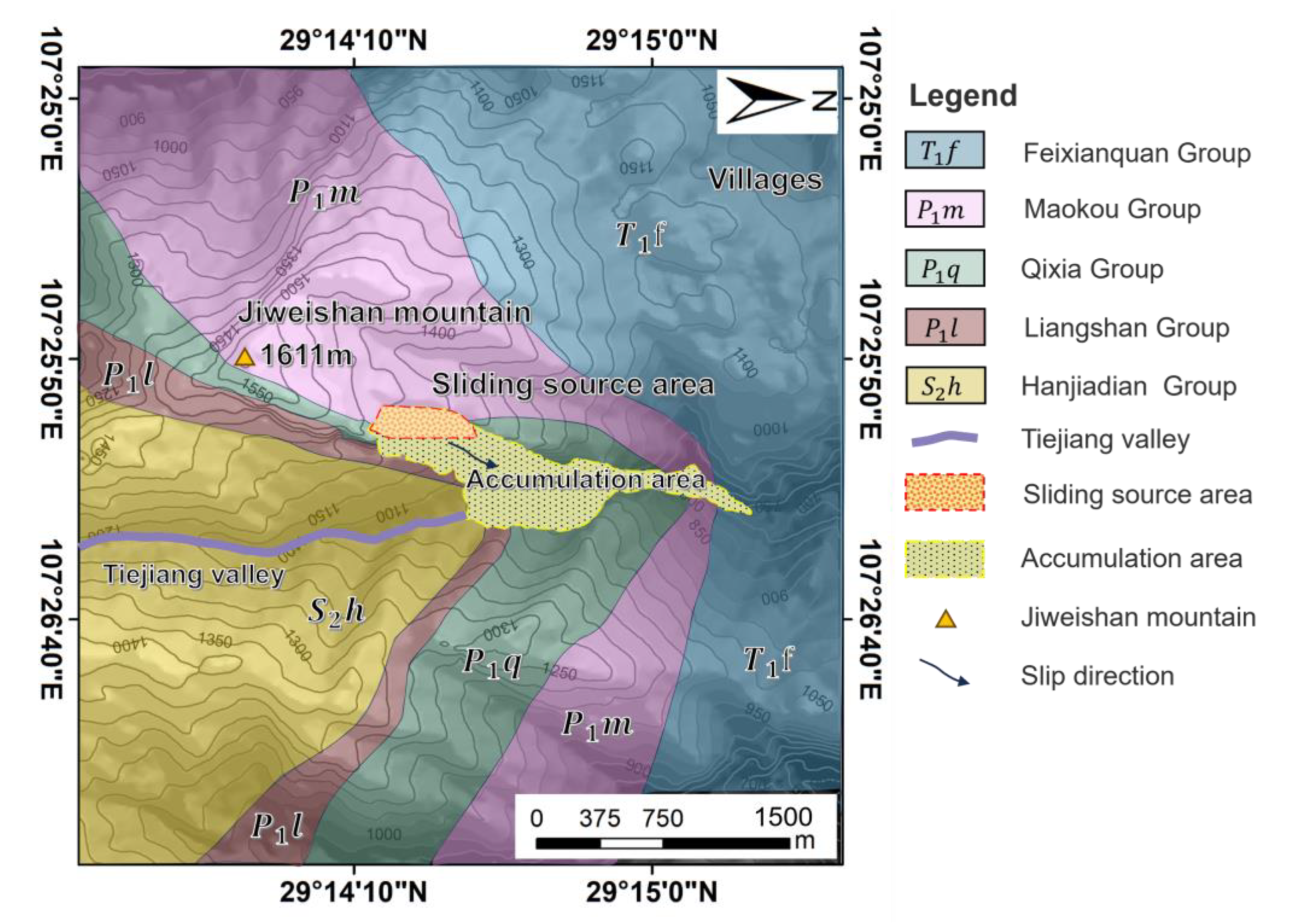
The geological strata of the Jiweishan rock avalanche research area is shown in Figure 2. The Jiweishan rock avalanche area is mainly composed of massive limestone of the Lower Permian Maokou Formation (P1m) and the Lower Permian Qixia Formation (P1q), and overlying sandstone of the Lower Permian Liangshan Formation (P1l) and the Middle Silurian Hanjiadian Formation (S2h). The foot of Jiweishan Mountain is mainly composed of Liangshan Formation sandstone (P1l) and Hanjiadian Group (S2h) [39,41].
The Jiweishan rock avalanche study area belongs to the central subtropical zone, with a mild climate and abundant rainfall. The annual average temperature in this area is 15–18 °C, and the annual rainfall is 1200–1400 mm [42]. Mid-subtropical plants dominate the region, and the vegetation types are evergreen broad-leaved forest, evergreen coniferous forest, evergreen coniferous and broad-leaved mixed forest, bamboo forest, and shrub forest. The main tree species are Cunninghamia lanceolata, Pinus massoniana, Fagus, Cryptomeria fortunei, Pinus tabulaeformis, Paulownia fortunei, Toona sinensis, bamboo and so on [43]. Among the dominant growth tree species in the Jiwei Mountain area, coniferous forest is Cunninghamia lanceolata and Pinus massoniana, broad-leaved forest is Fagus and Ginkgo biloba, and so on.
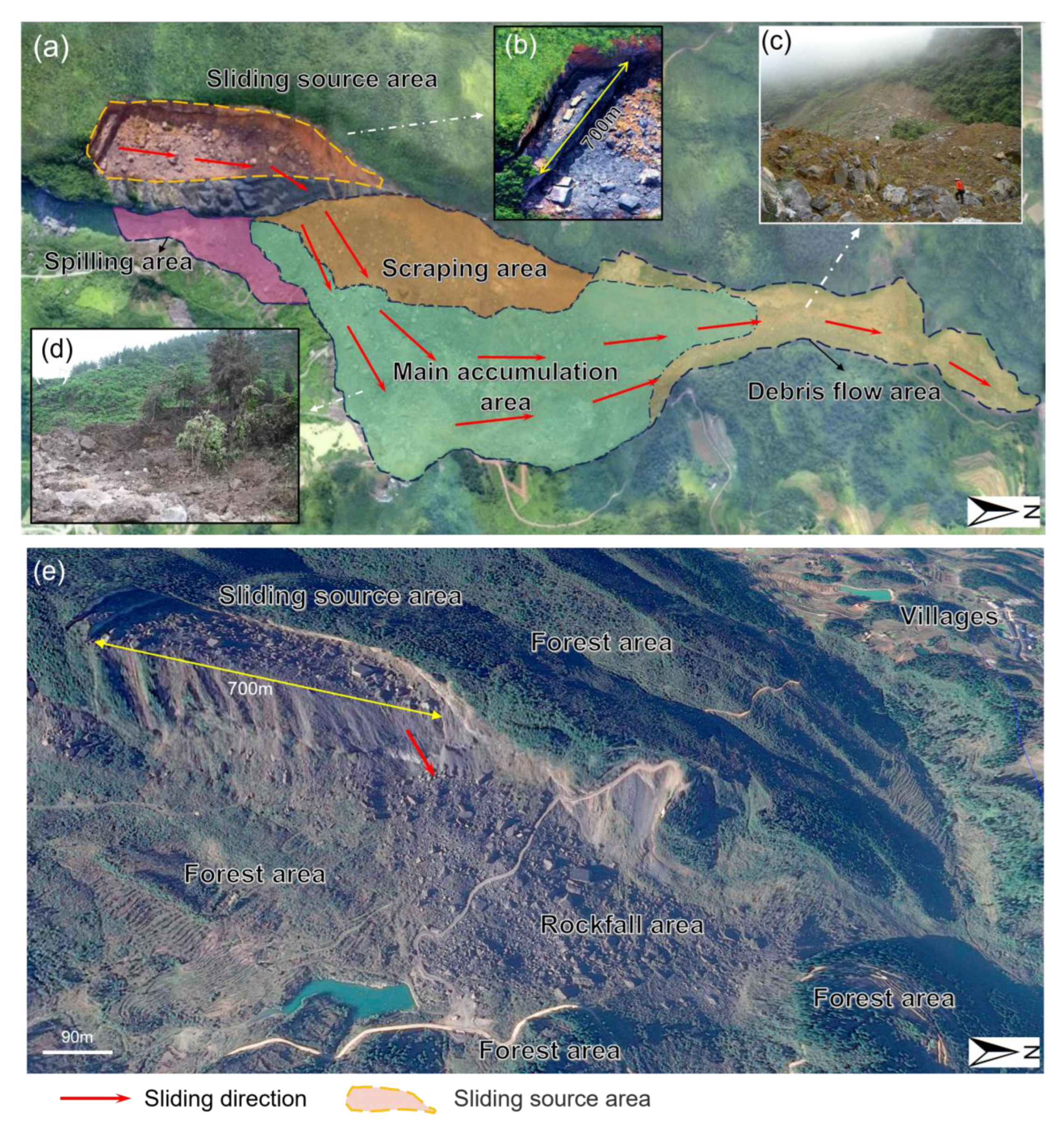
According to the field investigation and remote sensing image analysis, the rockfall deposits produced after the Jiweishan rock avalanche can be divided into four areas: a spilling area, scraping area, main accumulation area, and debris flow area, as shown in Figure 3a. There are obvious differences in the size distribution of rockfall in these four areas, as follows:
Spilling area: This area is located below the side of the sliding source area. When the main rock in the sliding source area slides down, some of the gravel rolls into this area. The rockfall in this area is small; the volume is mainly distributed between 5 and 10 m3, and the thickness of the accumulation is about 4–5 m. The field investigation found that the rockfall was blocked by the forest trees at the edge of the falling area and the opposite slope and no long-distance sliding was formed, as shown in Figure 3a.
Scraping area: This area is located directly below the sliding source area and is directly impacted by the rockfall in the sliding source area. The huge rockfall impact and scraping caused the surface vegetation forest in this area to be destroyed and buried. The size of rockfall in this area is large. The volume of falling rocks is mostly about 50–400 m3.
Main accumulation area: Most of the falling rocks caused by the rock avalanche accumulated in this area, with an average accumulation thickness of 50 m. This area was dominated by huge rockfalls, with a volume of 100–400 m3 accounting for the majority, and some of the rockfalls even exceeded 2000 m3 in volume [39]. In addition, from the impact of the huge falling rock, the debris and shoveled soil flew up and hit the forested area in the valley. The kinetic energy of the falling rock dissipated and it stopped moving, as shown in Figure 3d.
Debris flow area: This area is mainly distributed in the toe part of the rock avalanche accumulation area, located in the valley’s narrow area. It is composed of smaller rockfalls, mud, and rock debris, as shown in Figure 3c. The volume of rockfall in this area is between 1 and 10 m3.
3. Materials and Methods
3.1. Rockfall Simulations—RockyFor3D
Rockyfor3D is a three-dimensional (3D) point mass model, which is a probabilistic process based on calculating the 3D trajectory of a single individual falling rock [31]. It is worth mentioning that Rockyfor3D integrates the simulation of the blocking effect of trees on falling rocks, considering the protective effect of forests on falling rocks. Thus, the mitigating effect of forests on rockfalls can be evaluated by comparing the simulation results of the impact range of rockfalls on slopes with and without forests [45]. The Rockyfor3D model utilizes the GIS data format for model input, output, and visualization and allows the use of digital elevation models to represent the terrain and raster maps to represent the input parameters [46].
The RockyFor3D v5.2.14 software (ecorisQ, Bern, Switzerland) calculates the deviation and energy loss of a falling rock after impacting a tree, which depends on the tree DBH, the impact location, and the kinetic energy of the block prior to impact. Without knowing the exact location of the trees on the slope, the trees are randomly located within each pixel based on the number of trees assigned to each pixel (i.e., stand density). According to the study by Dorren and Berger [29], the maximum kinetic energy (EdissMax) that trees can absorb and thus dissipate depends on the DBH and tree type:
where EdissMax is the maximum kinetic energy that trees can dissipate (unit: J); FEratio is the fracture energy ratio of tree type and stem DBH (unit: cm). Rockyfor3D uses only two FEratio values: 0.93 for conifers and 1.59 for broad-leaved trees.
The main output of RockyFor3D consists of the maximum kinetic energy (95% confidence interval of all maximum kinetic energy values), the maximum bouncing distance, the maximum simulation velocity, the maximum tree impact height, and the number of tree impacts per cell.
3.2. Terrain Input Parameter Setting
The RockyFor3D model requires ten different input parameters [47], as shown in Table 1. The Digital Elevation Model (DEM) was created by using remote sensing data taken by NASA. Among them, rg70, rg20, and rg10 parameters represent the ‘roughness‘ of the slope in each DEM unit and specify the height of obstacles that rockfall will encounter in each DEM unit at 70%, 20%, and 10% [20]. Among them, rg70, rg20, rg10, and soil type parameters were estimated based on the geological exploration of the Jiweishan area by the Chongqing Institute of Geology and Mineral Resources. The specific parameter settings can be seen in Table 1 [47].
3.3. Forest Input Parameter Setting
The Rockyfor3D model calculates the energy consumption when the rockfall hits a tree by inputting the position, type, and DBH of the tree [32]. The forest parameters can be input to clearly calculate the trajectory and energy loss after the impact of rockfall and trees. Due to the lack of the growth position of trees in the rock avalanche area of Jiwei Mountain, this study randomly located the trees in each pixel according to the number of trees assigned to each DEM pixel [33]. According to the field investigation and consulting the Forestry Bureau of the study area, the planting density and tree species of the forest in the area were known. The forest in the study area is a mixed coniferous and broad-leaved forest. The forest planting density is about 800 trees per hectare. The trees are mainly spruce, Pinus massoniana, Fagus and Ginkgo biloba. In addition, through field investigation and field measurement, the percentage of coniferous and broad-leaved forests and the diameter at breast height (DBH) of the trunk were determined.
The forest stand parameters were entered as raster data in the form of a grid in the Rockyfor3D model, which in turn formed the set of forest parameters required for the simulation [47]. In order to compare the effect of forest structure on rockfall protection, in this study, pure deciduous forest, mixed coniferous forest, and pure coniferous forest were set up, respectively. The simulation control groups with different DBH and planting density were set up, respectively. The specific input parameters of the corresponding forest structure are shown in Table 2.
3.4. Simulation Method and Process
In order to facilitate the use of Rockyfor3D to analyze the protective effect of forests on rockfalls of different sizes after the occurrence of large-scale rockfall disasters, the following reasonable assumptions were made: It was assumed that the rockfalls in the source area disintegrated into rockfalls of different volumes before falling into contact with the ground. And rock disintegration caused by the impact of rockfall and the ground was not considered. That is, the rockfall volume input in the Rockyfor3D simulation was the volume when the falling rocks finally stopped moving.
On this basis, the size of rockfall produced by rock avalanches can be classified, as shown in Figure 3e, which is a satellite image of the final size distribution of falling rocks after the rock avalanche. According to the geological exploration of the Jiweishan rockfall, the size of falling rocks can be divided into five categories: super-large-size (a volume greater than 400 m3) rockfall, mainly distributed in the main accumulation area; extra-large-size (100–400 m3) rockfall, mainly distributed in the main accumulation area and scraping area; large size (30–60 m3) rockfall, mainly distributed in the spilling area and debris flow area; medium-size (5–10 m3) rockfall, mainly distributed in the debris flow area and spilling area; and small-size (1–5 m3) rockfall, mainly distributed in the debris flow area [39,41].
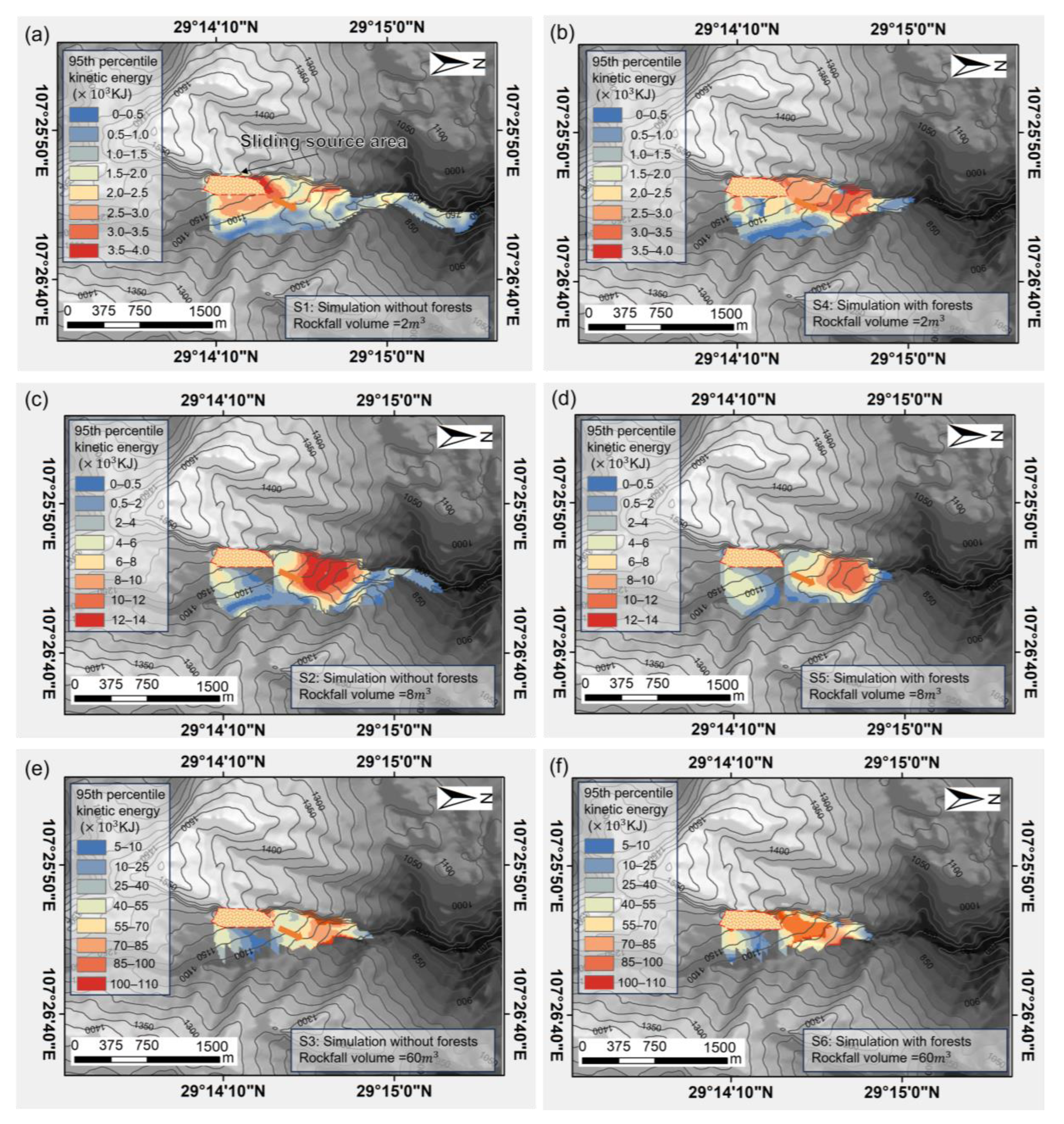
According to the classification results of rockfall size, three groups of rockfall sizes were set as simulation input parameters, which were large rock (60 m3), medium rock (8 m3), and small rock (2 m3). A Rockyfor3D simulation of three sizes of falling rocks with forest and without forest was carried out, respectively. A total of 6 groups of basic simulation tests were carried out. It was assumed that there were 200 large-size rockfall (60 m3) events, 500 medium-size rockfalls (8 m3), and 1000 small-size rockfalls (2 m3) which occurred in the rock avalanche event. The six groups of basic tests were simulated a total of 3400 times. The specific simulation parameters are shown in Table 3. In addition, to study the protective effect of forest structure on rockfall, another four groups of tests were carried out by changing the DBH and planting density parameters.
When using the Rockyfor3D model to simulate and calculate, the whole area of the Jiweishan rock avalanche was divided into polygons according to the method developed by Doreen [31] and simulated according to the raster data in Table 1. Before running the simulation in Rockyfor3D, the following parameters were set: the rock volume change was ±5% and the additional initial fall height was 3 m. The rockfall protection effect with or without forest and different forest structures can be obtained by comparing the rockfall propagation area and the final runout distance of the superimposed rockfall trajectory simulation results [20].
4. Results
4.1. Characteristics of Path Distribution of Falling Rocks of Different Sizes after Rockfalls
The simulation trajectory superposition results of the Jiweishan rock avalanche using the Rockyfor3D tool are shown in Figure 4. It can be seen that the simulation results match well with the actual rock avalanche propagation area shown in Figure 3. Specifically, the simulation results of the rockfall with forest are the same as the real situation, where it gradually diffused and rolled down along the Tiejiang Valley from high to low. By comparing the grid of the simulation results with the grid of the actual rock avalanche propagation area, it can be seen that the coincidence rate between the simulation results of small-size rockfalls and the actual rockfall area reached 84%. The coincidence rate between the simulation results of large-size rockfall and the actual rockfall area reached 68%. In addition, it can be seen from the simulation results in Figure 4 that the paths and final accumulation areas of falling rocks of different sizes are different. The final accumulation area of 2 m3 small-size rock and 8 m3 medium-size rock is located in the narrow mouth area of the valley, as shown in Figure 4a–d. The final position of the large-size rockfall of 60 m3 is mainly distributed in the spilling area, the main accumulation area, and the scraping area, as shown in Figure 4e,f. This is similar to the statistical results of Zou et al. [39] for the size distribution of rockfalls in the Jiweishan rock avalanche.
In actual Jiweishan rock avalanche rockfall events, large-size rockfalls will obtain greater potential energy when falling and will have a scraping effect on the ground rock and soil when in contact with the ground, even falling into the ground [37,39,41]. The process of scraping consumes most of the potential energy, which leads to a decrease in the kinetic energy of the rockfall moving forward [48]. Concomitantly, due to the influence of valley terrain, the falling process of rockfall will be blocked by the opposite slope, meaning that the final stopping distance of the large-size rockfall is shorter. As a result, large-size rockfalls are mainly distributed in areas close to the source area. The smaller-size falling rocks have less potential energy, and the scraping effect on the ground is small or even negligible. Therefore, the kinetic energy of rockfall sliding can be retained, resulting in a longer runout distance for small-sized rockfalls.
In addition, the disintegration in the falling rock movement is also responsible for the small-sized falling rock having a longer runout distance. Gerard Matas et al. [49] investigated the size distribution of rockfalls considering rock fragmentation when applying the RockGIS model to simulate rockfall tests. The results show that the large-size falling rocks were mainly concentrated at the foot of the hillside, while the small-size falling rocks achieved a longer jumping distance. This is similar to the actual situation as well as the simulation results of rockfall size distribution in the Jiweishan rock avalanche. However, considering the limitation of RockyFor3D software and the convenience of simulating forest protection rockfalls, the disintegration and fragmentation effect of falling rocks was not considered in this study.
4.2. Assessment of the Effectiveness of Forest Protection against Rockfalls
Figure 4 shows the results of three sizes (2 m3, 8 m3, and 60 m3) of rockfall simulated by the Rockyfor3D tool considering two scenarios (with forest and without forest). Figure 4a,c,e are the results of simulating rockfalls without forest. Figure 4b,d,f are the results of simulating rockfalls with forest. It can be seen that the rockfall simulation results of the two scenarios are consistent with the shape of the actual rockfall area. By comparing the two groups of simulation results, the rockfall propagation area with forest is smaller than that without forest. This shows that the forest has a protective effect on the rockfall of the Jiweishan rock avalanche, especially for small-size rockfalls, for which the protective effect of the forest is particularly obvious.
Through calculation and a comparison of the simulation results, it was found that the protection ability of the forest against rockfall is different for different sizes of rocks. The results of the Rockyfor3D simulation of different volumes of rockfall propagation area with and without forest are shown in Table 4. The simulation results show that the forest had the best protective effect on small-size rocks, and the propagation area of small-size rockfall with forest protection was 16.28% lower than that without forest protection. The propagation area of medium-sized rockfall with forest protection was 15.81% lower than that without forest. However, for large-size rockfalls, the simulation results show that the protection effect of forests was minimal, and the rockfall propagation area with forests was only 0.37% lower than that without forests.
The protective effect of forest on rockfall is related to the ability of trees to consume the impact energy of rock [27]. The reduction in the propagation area of small falling rocks by forest protection is higher than that of large falling rocks (Figure 5). Trees usually have sufficient resistance against small rockfalls with low sliding kinetic energy to prevent them from continuing to slide [45]. Therefore, for small falling rocks, most of the kinetic energy will be offset when they hit the trees, causing the rock to slow down and stop. On the contrary, for large falling rocks, the kinetic energy during sliding is so large that it can reach 100 MJ, so trees cannot withstand the huge impact of the rocks and break or even root up (Figure 3d). Although tree trunks and canopies can counteract some of the energy from rock impact, falling rocks can continue to slide or deflect and collide with other trees until they stop [34]. Therefore, forests provide effective protection against small-sized rockfall events. However, forests have limited protection against large-sized rockfalls. Consequently, it is necessary to mitigate the threat of falling rocks in hazardous areas with large rockfalls by installing metal rockfall protection nets, concrete barriers, and other measures. In some cases, it may even be necessary to relocate buildings and people in the path of large rockfalls to ensure safety.
4.3. Influence of Forest Structure on the Effectiveness of Rockfall Protection
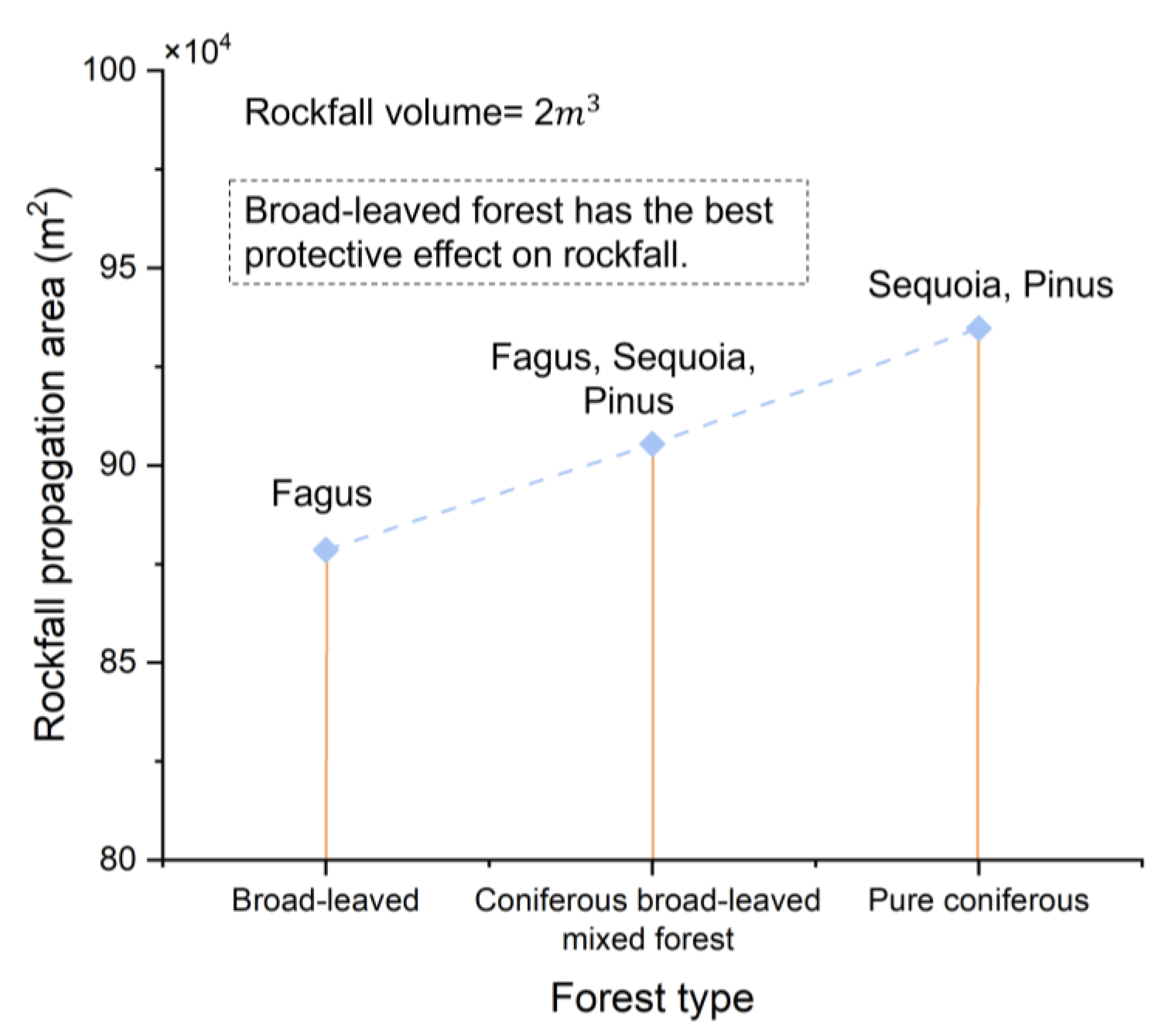
The protection potential of forests against falling rocks is closely related to the forest structure and the growth period of trees [50,51]. The protection effect of three forest types, namely broad-leaved forest, mixed forest, and coniferous forest, against falling rocks with a volume of 2 m3 was simulated in Rockyfor3D. The simulation results are shown in Figure 6. The rockfall simulation showed that broad-leaved forests would have significantly higher protection ability than mixed forests and pure coniferous forests, and the Rockyfor3D-simulated rockfall propagation areas and runout distances are shown in Table 5. In addition, the protection effect of pure coniferous forests against rockfall was simulated for different growth periods (tree DBH) and planting density, respectively.
As shown in Figure 6 and Figure 7, the final propagation area of rockfall simulated by broad-leaved forest was 6% lower than that of coniferous forest, and the final runout distance was 13% lower than that of coniferous forest. It can be seen that when the same size of rockfall occurred, the broad-leaved forest had the best protective effect (Figure 6a), followed by the coniferous broad-leaved mixed forest (Figure 6b), and the pure coniferous forest had the worst protective effect on rockfall (Figure 6c). Therefore, planting broad-leaved forest with the same area and quantity can provide the most effective protection in the event of rockfall events, thereby reducing the impact range of rockfall.
Moreover, the protective effect of forest on rockfall changes dynamically with the development of trees. The resistance of trees to rockfall is directly related to the DBH and the density of the crown. Rockyfor3D software was used to simulate the rockfall propagation trajectory of pure coniferous forest with a tree DBH of 30, 35 and 40 cm. The simulated rockfall propagation area and runout distance are shown in Figure 8a. The results show that for coniferous forest, with the growth of trees, the DBH increases, and the propagation area and runout distance of rockfall clearly decrease under the protection of forest. This shows that the larger the DBH of the trees in the forest, the stronger the rockfall interception ability that the trees can provide. Research conducted by Maringer [52] found that thicker trunks can offset more energy from rockfalls. Therefore, it is recommended to plant fast-growing trees in areas with rockfall risk to provide the most timely and effective protection.
Another important factor affecting the protective effect of forest on rockfall is the planting density of forest trees. The Rockyfor3D software was used to test the trajectory of rockfall propagation in pure coniferous forests with planting densities of 400, 600, and 800 trees per hectare. The simulated rockfall propagation area and runout distance are shown in Figure 8b. Evidently, with the increase in tree-planting density, the propagation area and final runout distance of rockfall decreased. With the increase in forest density, the probability of trees intercepting falling rocks increased, and the protective effect of forests on rockfalls increased significantly. Therefore, the rational planning and management of tree-planting density significantly positively impacts forest rockfall protection.
5. Discussion
5.1. Rock Size Influences Forests’ Rockfall Protection Effect
Forests have a positive protective effect on rockfall [50,53]. The protection potential of forests against rockfalls is related to the size of the falling rocks. This study found that the protective effect of forests is more obvious for small falling rocks. The reason is that the kinetic energy of large-sized rockfalls is large, so trees cannot withstand huge shocks. In most cases, large rockfalls will directly destroy and break trees. Although the impact of rockfalls and trees can offset some of the kinetic energy, it has little protective effect on large-scale rockfalls. These results are consistent with the results of Dorren’s latest study [36], which also found that the protective effect of forests decreases with the increase in falling rock volume.
In addition, there are differences in the final distribution areas of rockfalls with different volumes after rock avalanches. For example, small rockfalls tend to turn into debris flows and travel longer distances along valleys, posing a greater threat to villages and buildings downstream [54]. Therefore, the protection of small-size rockfalls is particularly important. In response to this problem, the results of this study can provide guidance for forest planning in valleys. Dominant broad-leaved trees, such as Eucalyptus, Platanus orientalis, Betula alnoides, Ginkgo trees with fast-growing properties, etc., [55] can be planted densely in the valley rockfall movement path to obtain the most effective rockfall protection ability in a short time.
However, large-scale rockfalls have a strong impact, and trees in forests alone cannot provide effective protection. Although related studies have found that forest trees can offset part of the impact energy of large-scale rockfalls [56], due to the strong destruction ability of rockfalls on trees, trees have less ability to limit the propagation area and runout distance of large rockfalls (Figure 5). Therefore, in hidden-danger areas where large-scale rockfalls may occur, it is necessary to establish a rockfall protection network or construct a concrete retaining wall to block and reduce the harm of large rockfalls [16].
5.2. Influencing Factors of Forest Structure on Mitigating Rockfall Hazards
The trunk and crown of trees can intercept rockfall and become a natural physical barrier to slow down the impact of rockfall, as shown in Figure 9. Forest structure is closely related to the protective effect of rockfall [31,35]. Different tree species, planting density, and growth periods (tree DBH) of trees have a great influence on the potential for rockfall protection. Broad-leaved forest has a greater advantage in the protection of rockfall than coniferous forest in the same situation because of its dense and complex canopy. The probability of a falling rock striking a broad-leaved forest tree will be significantly higher than that of a coniferous forest tree, so it will be more able to intercept and weaken the energy of the falling rock. Broad-leaved forests consist of broad-leaved tree species, such as Platanus orientalis, maple, etc. These trees typically have broad canopies and abundant branching, creating a denser forest structure. This structure helps to increase physical barriers and improves the effectiveness of blocking falling rocks. In contrast, coniferous forests are usually composed of coniferous species such as pines and spruces. These trees have relatively narrow canopies, taller trunks, and fewer branches [57]. This structure may not be as dense as that of broad-leaved forests. Therefore, it is relatively ineffective in blocking rockfall. As shown in Figure 6 and Figure 7, the propagation distance and area of rockfall in the simulation results of a broad-leaved forest scene are smaller than those of a pure coniferous forest. In addition, the effect of tree-planting density on forest protection against rockfall is also crucial (Figure 8b). The greater the planting density of the same kind of trees, the denser the physical barrier that can be provided for the rockfall, and the higher the probability of the rockfall hitting the trees, the better the protective effect that can be provided [58]. Therefore, under the premise of conforming to the growth environment of trees, planning more intensive forests can provide more effective protection for rockfall disasters.
The growth period (tree DBH) of a tree also significantly affects the effectiveness of rockfall protection. Trees of different growth periods have different physical characteristics and structures. Therefore, their effectiveness in mitigating and protecting against rockfall risk varies [59]. Typically, large-DBH trees have taller and wider crowns and more foliage. Therefore, they are more effective in intercepting falling rocks and preventing them from continuing to roll downhill. This was verified by the results of a study of rockfalls on the Jiweishan rock avalanche (Figure 8a). NaiS STEINSCHLAG-TOOL is a powerful tool that allows estimating the protective effect of forests against rockfall and calculating the corresponding forest demand profile [60]. The NaiS tool was applied to calculate and compare the effect of forest protection against rockfall in the Jiweishan rock avalanche area. The same parameters as Rockyfor3D were entered into the NaiS tool. The calculations showed that the minimum planting density of pure coniferous forests (100% spruces) with a DBH of 12–24 cm required to achieve the desired forest protection against rockfall was 450 ha−1. In comparison, the minimum planting density for the same scenario with trees of DBH 24–36 cm was only 150 ha−1. Moreover, when switching from a pure coniferous forest with a DBH of 12–24 cm to a pure broadleaf forest (100% Fagus), the minimum planting density required to achieve protection against rockfall was 400 ha−1. From the results, it was found that the larger the DBH of the trees in the forest, the more rockfall interception capacity it can provide. Moreover, broadleaf forests provide greater rockfall protection than coniferous forests. This is similar to the results obtained in this study.
It is well known that the DBH of a tree is usually positively related to its height. A portion of the debris generated by a rockfall will be airborne, so taller trees are effective in intercepting small airborne rockfalls, as shown in Figure 9b. Moreover, the larger the DBH of the tree and the deeper the root system, the stronger the tree will be and the more energy it will be able to withstand from falling rocks [50,53]. Smaller-DBH trees may be broken or even uprooted by falling rocks, thus failing to provide effective deceleration and blocking effects on falling rocks.
Furthermore, when a large rock avalanche occurs, it will be accompanied by the generation of huge air currents, and the winds created by these air currents will first impact the forest [39]. The roots of large-DBH trees are deep, which are relatively more resistant to wind and reduce forest damage caused by wind, maintaining the integrity of the forest and reducing the harm of rockfall. Small-DBH trees may be more likely to be damaged under strong wind conditions, thus weakening their effectiveness in protecting rockfalls.
5.3. Forest Management and Policy Recommendations for Rockfall Hazard Areas
The terrain of Southwest China is predominantly mountainous, with extremely complex geological formations [61,62,63]. Rockfall disasters are easily induced by factors such as rainfall and earthquakes. At the same time, the region is rich in forest resources. For example, the forest coverage rate in Chongqing is 55.04%, and the forest stock reaches 260 million cubic meters [64,65]. Therefore, it is of great practical significance to formulate and promote reasonable tree-planting policies and make full use of forests as natural barriers to reduce rockfall disasters.
The Chongqing area is rich in tree species suitable for growth, including broad-leaved forests such as Fagus, Suigengang, Eucalyptus, and Ginkgo. Coniferous forests include spruce and pine [66]. Based on the results of this paper, it is possible to provide suggestions for forest planning in areas with rockfall hazards in Chongqing. In order to effectively utilize forests to protect against rockfalls in a timely manner, economic and fast-growing broadleaf forests or mixed coniferous and broadleaf forests can be planted in the possible paths of rockfalls in the hazardous areas, and reasonable tree-planting densities and planting areas can be formulated under the premise of suitable tree growth densities, so as to provide the most effective protection against rockfalls. However, the protective effect of forests is not always effective, and for larger rockfalls, the protective effect of forest trees will be very limited. Therefore, other protective measures (e.g., metal fences, concrete retaining walls, etc.) need to be used in conjunction with other protective measures to further increase safety in areas identified as being at risk from large rockfalls.
6. Conclusions
In this study, Rockyfor3D software was used to simulate and analyze the with-forest and without-forest scenes of the Jiweishan rock avalanches in Southwest China. The effects of falling rock size and forest structure on forest protection rockfall were discussed. Specifically, the forest had obvious potential for rockfall protection, especially for small-size rockfalls, for which the protection effect was optimal. The greater the density of forest planting, the larger the DBH of trees and the higher the protective effect. In addition, the study found that pure broad-leaved forest had the best protective effect on rockfall, followed by mixed forest, and the worst was pure coniferous forest.
It is worth noting that the protective effect of forest on rockfall is not constant, and it will change dynamically according to the renewal of forest structure. In addition, the effect of trees on preventing rockfall depends on many factors, including tree species, tree-planting density, and tree DBH. Although trees have significant advantages in reducing the risk of small rockfalls, they may not eliminate all risks, especially in areas where large rockfalls may occur. In such cases, other engineering measures (such as concrete retaining walls or metal mesh systems) are used in conjunction with forests to enhance protection. Finally, this study puts forward feasible suggestions for applying forest rockfall protection in Southwest China to make full use of the natural advantages of trees to solve the rockfall problem.
In conclusion, this study emphasizes that forests can provide a natural complement to rockfall protection. The effect of forests on the effectiveness of rockfall protection depends on the forest structure (tree species, DBH, planting density, etc.) and the size of falling rocks. However, this study does not consider rock decomposition in rockfalls, which will be the focus of future research. The results of this paper can provide research ideas for the application of forests to rockfall protection in Southwest China and in similar scenarios around the world and can also provide guidance for reforestation and forest management in rockfall hazard sites.
Author Contributions
Conceptualization, H.Y. and K.S.; methodology, K.S. and L.Q.; formal analysis, K.S. and C.C.; data curation, D.L. and L.C.; writing—original draft preparation, K.S.; writing—review and editing, K.S. and H.Y.; project administration, L.C.; funding acquisition, H.Y. and L.C. All authors have read and agreed to the published version of the manuscript.
Funding
The financial support from the National Key Research and Development Program of China (No. 2021YFB3901403) and Project supported by graduate research and innovation foundation of Chongqing, China (Grant No. CYS23115) are greatly appreciated. We sincerely thank the survey report provided by the Chongqing Institute of Geology and Mineral Resources.
Data Availability Statement
The data provided in this study can be provided at the request of the corresponding author. The simulations are based on the three-dimensional rockfall model RockyFor3D, accessible on www.ecorisq.org.
Conflicts of Interest
The authors declare no conflict of interest.
References
- Shugar, D.H.; Jacquemart, M.; Shean, D.; Bhushan, S.; Upadhyay, K.; Sattar, A.; Schwanghart, W.; McBride, S.; de Vries, M.V.W.; Mergili, M.; et al. A Massive Rock and Ice Avalanche Caused the 2021 Disaster at Chamoli, Indian Himalaya. Science 2021, 373, 300–306. [Google Scholar] [CrossRef]
- Noël, F.; Nordang, S.F.; Jaboyedoff, M.; Digout, M.; Guerin, A.; Locat, J.; Matasci, B. Comparing Flow-R, Rockyfor3D and RAMMS to Rockfalls from the Mel de La Niva Mountain: A Benchmarking Exercise. Geosciences 2023, 13, 200. [Google Scholar] [CrossRef]
- Wen, H.; Hu, J.; Zhang, J.; Xiang, X.; Liao, M. Rockfall Susceptibility Mapping Using XGBoost Model by Hybrid Optimized Factor Screening and Hyperparameter. Geocarto Int. 2022, 37, 16872–16899. [Google Scholar] [CrossRef]
- Yang, H.Q.; Xing, S.G.; Wang, Q.; Li, Z. Model Test on the Entrainment Phenomenon and Energy Conversion Mechanism of Flow-like Landslides. Eng. Geol. 2018, 239, 119–125. [Google Scholar] [CrossRef]
- Yang, H.; Zhou, X. A New Approach to Calculate Trajectory of Rockfall. Rock Soil Mech. 2009, 30, 3411–3416. [Google Scholar]
- Fanos, A.M.; Pradhan, B.; Aziz, A.A.; Jebur, M.N.; Park, H.-J. Assessment of Multi-Scenario Rockfall Hazard Based on Mechanical Parameters Using High-Resolution Airborne Laser Scanning Data and GIS in a Tropical Area. Environ. Earth Sci. 2016, 75, 1129. [Google Scholar] [CrossRef]
- Jiang, N.; Li, H.; Liu, M.; Zhang, J.; Zhou, J. Quantitative Hazard Assessment of Rockfall and Optimization Strategy for Protection Systems of the Huashiya Cliff, Southwest China. Geomat. Nat. Hazards Risk 2020, 11, 1939–1965. [Google Scholar] [CrossRef]
- Jiang, N.; Li, H.; Zhou, J. Quantitative Hazard Analysis and Mitigation Measures of Rockfall in a High-Frequency Rockfall Region. Bull. Eng. Geol. Environ. 2021, 80, 3439–3456. [Google Scholar] [CrossRef]
- Wen, H.; Hu, J.; Zhang, J.; Xiang, X.; Liao, M. Explainable Machine Learning Model for Rockfall Susceptibility Evaluation. Geo-Risk 2023, 102–110. [Google Scholar] [CrossRef]
- Luo, H.; Hu, W.; Zhang, X.; McSaveney, M.; Li, Y. The Study on Rock Thermal Fractures at Sliding Surface of Jiweishan Landslide. Eng. Geol. 2022, 300, 106588. [Google Scholar] [CrossRef]
- Zhang, M.; McSaveney, M.; Shao, H.; Zhang, C. The 2009 Jiweishan Rock Avalanche, Wulong, China: Precursor Conditions and Factors Leading to Failure. Eng. Geol. 2018, 233, 225–230. [Google Scholar] [CrossRef]
- Yin, Y.; Sun, P.; Zhang, M.; Li, B. Mechanism on Apparent Dip Sliding of Oblique Inclined Bedding Rockslide at Jiweishan, Chongqing, China. Landslides 2011, 8, 49–65. [Google Scholar] [CrossRef]
- Yang, H.Q.; Lan, Y.F.; Lu, L.; Zhou, X.P. A Quasi-Three-Dimensional Spring-Deformable-Block Model for Runout Analysis of Rapid Landslide Motion. Eng. Geol. 2015, 185, 20–32. [Google Scholar] [CrossRef]
- Sellmeier, B.; Thuro, K. Comparison of Two 3D Rockfall Codes on Behalf of a Case Study in the Bavarian Alps. Geomech. Tunn. 2017, 10, 15–23. [Google Scholar] [CrossRef]
- Eichel, J.; Stoffel, M.; Wipf, S. Go or Grow? Feedbacks between Moving Slopes and Shifting Plants in High Mountain Environments. Prog. Phys. Geogr. Earth Environ. 2023, 0, 1–19. [Google Scholar] [CrossRef]
- Moos, C.; Thomas, M.; Pauli, B.; Bergkamp, G.; Stoffel, M.; Dorren, L. Economic Valuation of Ecosystem-Based Rockfall Risk Reduction Considering Disturbances and Comparison to Structural Measures. Sci. Total Environ. 2019, 697, 134077. [Google Scholar] [CrossRef]
- Dupire, S.; Bourrier, F.; Monnet, J.-M.; Bigot, S.; Borgniet, L.; Berger, F.; Curt, T. The Protective Effect of Forests against Rockfalls across the French Alps: Influence of Forest Diversity. For. Ecol. Manag. 2016, 382, 269–279. [Google Scholar] [CrossRef]
- Moos, C.; Lischke, H. Modeling the Effect of Rockfall on Forest Development in a Dynamic Forest Landscape Model. Ecosphere 2022, 13, e3909. [Google Scholar] [CrossRef]
- Lanfranconi, C.; Frattini, P.; Sala, G.; Dattola, G.; Bertolo, D.; Sun, J.; Crosta, G.B. Accounting for the Effect of Forest and Fragmentation in Probabilistic Rockfall Hazard. Nat. Hazards Earth Syst. Sci. 2023, 23, 2349–2363. [Google Scholar] [CrossRef]
- Moos, C.; Fehlmann, M.; Trappmann, D.; Stoffel, M.; Dorren, L. Integrating the Mitigating Effect of Forests into Quantitative Rockfall Risk Analysis—Two Case Studies in Switzerland. Int. J. Disaster Risk Reduct. 2018, 32, 55–74. [Google Scholar] [CrossRef]
- Dorren, L.K.A.; Berger, F.; Imeson, A.C.; Maier, B.; Rey, F. Integrity, Stability and Management of Protection Forests in the European Alps. For. Ecol. Manag. 2004, 195, 165–176. [Google Scholar] [CrossRef]
- Moos, C.; Khelidj, N.; Guisan, A.; Lischke, H.; Randin, C.F. A Quantitative Assessment of Rockfall Influence on Forest Structure in the Swiss Alps. Eur. J. For. Res. 2021, 140, 91–104. [Google Scholar] [CrossRef]
- Dupire, S.; Toe, D.; Barré, J.-B.; Bourrier, F.; Berger, F. Harmonized Mapping of Forests with a Protection Function against Rockfalls over European Alpine Countries. Appl. Geogr. 2020, 120, 102221. [Google Scholar] [CrossRef]
- Corona, C.; Trappmann, D.; Stoffel, M. Parameterization of Rockfall Source Areas and Magnitudes with Ecological Recorders: When Disturbances in Trees Serve the Calibration and Validation of Simulation Runs. Geomorphology 2013, 202, 33–42. [Google Scholar] [CrossRef]
- Radtke, A.; Toe, D.; Berger, F.; Zerbe, S.; Bourrier, F. Managing Coppice Forests for Rockfall Protection: Lessons from Modeling. Ann. For. Sci. 2014, 71, 485–494. [Google Scholar] [CrossRef]
- Jonsson, M.J. Energy Absorption of Trees in a Rockfall Protection Forest, Royal Institute of Technology Stockholm. Ph.D. Dissertation, ETH, Zurich, Switzerland, 2007. [Google Scholar]
- Lundström, T.; Jonsson, M.J.; Volkwein, A.; Stoffel, M. Reactions and Energy Absorption of Trees Subject to Rockfall: A Detailed Assessment Using a New Experimental Method. Tree Physiol. 2009, 29, 345–359. [Google Scholar] [CrossRef] [PubMed]
- Bigot, C.; Dorren, L.K.A.; Berger, F. Quantifying the Protective Function of a Forest against Rockfall for Past, Present and Future Scenarios Using Two Modelling Approaches. Nat. Hazards 2009, 49, 99–111. [Google Scholar] [CrossRef]
- Dorren, L.K.A.; Maier, B.; Putters, U.S.; Seijmonsbergen, A.C. Combining Field and Modelling Techniques to Assess Rockfall Dynamics on a Protection Forest Hillslope in the European Alps. Geomorphology 2004, 57, 151–167. [Google Scholar] [CrossRef]
- Leine, R.I.; Schweizer, A.; Christen, M.; Glover, J.; Bartelt, P.; Gerber, W. Simulation of Rockfall Trajectories with Consideration of Rock Shape. Multibody Syst. Dyn. 2014, 32, 241–271. [Google Scholar] [CrossRef]
- Dorren, L.K.A.; Berger, F.; Putters, U.S. Real-Size Experiments and 3-D Simulation of Rockfall on Forested and Non-Forested Slopes. Nat. Hazards Earth Syst. Sci. 2006, 6, 145–153. [Google Scholar] [CrossRef]
- Dupire, S.; Bourrier, F.; Monnet, J.-M.; Bigot, S.; Borgniet, L.; Berger, F.; Curt, T. Novel Quantitative Indicators to Characterize the Protective Effect of Mountain Forests against Rockfall. Ecol. Indic. 2016, 67, 98–107. [Google Scholar] [CrossRef]
- van Veen, M.; Hutchinson, D.J.; Bonneau, D.A.; Sala, Z.; Ondercin, M.; Lato, M. Combining Temporal 3-D Remote Sensing Data with Spatial Rockfall Simulations for Improved Understanding of Hazardous Slopes within Rail Corridors. Nat. Hazards Earth Syst. Sci. 2018, 18, 2295–2308. [Google Scholar] [CrossRef]
- Menk, J.; Berger, F.; Moos, C.; Dorren, L. Towards an Improved Rapid Assessment Tool for Rockfall Protection Forests Using Field-Mapped Deposited Rocks. Geomorphology 2023, 422, 108520. [Google Scholar] [CrossRef]
- Kajdiž, P.; Diaci, J.; Rebernik, J. Modelling Facilitates Silvicultural Decision-Making for Improving the Mitigating Effect of Beech (Fagus Sylvatica L.) Dominated Alpine Forest against Rockfall. Forests 2015, 6, 2178–2198. [Google Scholar] [CrossRef]
- Dorren, L.; Schaller, C.; Erbach, A.; Moos, C. Automated Delimitation of Rockfall Hazard Indication Zones Using High-Resolution Trajectory Modelling at Regional Scale. Geosciences 2023, 13, 182. [Google Scholar] [CrossRef]
- Xu, Q.; Fan, X.; Huang, R.; Yin, Y.; Hou, S.; Dong, X.; Tang, M. A Catastrophic Rockslide-Debris Flow in Wulong, Chongqing, China in 2009: Background, Characterization, and Causes. Landslides 2010, 7, 75–87. [Google Scholar] [CrossRef]
- Zhao, Z.; Deng, L. Initiation Mechanism of Jiweishan High-Speed Rockslide in Chongqing, China. Nat. Hazards 2020, 103, 3765–3781. [Google Scholar] [CrossRef]
- Zou, Z.; Tang, H.; Xiong, C.; Su, A.; Criss, R.E. Kinetic Characteristics of Debris Flows as Exemplified by Field Investigations and Discrete Element Simulation of the Catastrophic Jiweishan Rockslide, China. Geomorphology 2017, 295, 1–15. [Google Scholar] [CrossRef]
- Ge, Y.; Tang, H.; Ez Eldin, M.A.M.; Chen, H.; Zhong, P.; Zhang, L.; Fang, K. Deposit Characteristics of the Jiweishan Rapid Long-Runout Landslide Based on Field Investigation and Numerical Modeling. Bull. Eng. Geol. Environ. 2019, 78, 4383–4396. [Google Scholar] [CrossRef]
- Yang, L.; Zhang, M.; Jiao, W.; Wu, Y.; Zhang, C.; Wang, Z. Influence of Intergranular Friction Weakening on Rock Avalanche Dynamics. Comput. Geotech. 2023, 159, 105440. [Google Scholar] [CrossRef]
- Chen, L.; Yang, H.; Song, K.; Huang, W.; Ren, X.; Xu, H. Failure Mechanisms and Characteristics of the Zhongbao Landslide at Liujing Village, Wulong, China. Landslides 2021, 18, 1445–1457. [Google Scholar] [CrossRef]
- The Wulong Karst Area Has the Following Types of Forests and Plant Communities. Available online: https://en.wikipedia.org/wiki/Wulong_Karst (accessed on 3 May 2023).
- Yang, L.; Zhang, M.; Zhang, C.; Wang, Z.; Li, W.; Wu, Y.; Wang, L.; Yan, G. How Strain- and Strain-Rate- Weakening of Rupture-Surface Strength Affects Rapid Landslides Explored through Numerical Models of the 2009 Jiweishan Rock Avalanche. Eng. Geol. 2022, 303, 106668. [Google Scholar] [CrossRef]
- Marija, L.; Martin, Z.; Jordan, A.; Matthew, P. Rockfall Susceptibility and Runout in the Valley of the Kings. Nat. Hazards 2022, 110, 451–485. [Google Scholar] [CrossRef]
- Dorren, L.K.A. Using GIS for Preparing Rockyfor3D Input Data in 10 Steps. Available online: https://www.yumpu.com/en/document/view/41913274/using-gis-for-preparing-rockyfor3d-input-data-in-10-steps-ecorisq (accessed on 5 April 2023).
- Dorren, L.K.A. Rockyfor3D (v5.2) Revealed—Transparent Description of the Complete 3D Rockfall Model. Available online: https://www.ecorisq.org/publications/tools-manuals/rockyfor3d-user-manual/3-english/file (accessed on 5 April 2023).
- Zhou, J.; Cui, P.; Hao, M. Comprehensive Analyses of the Initiation and Entrainment Processes of the 2000 Yigong Catastrophic Landslide in Tibet, China. Landslides 2016, 13, 39–54. [Google Scholar] [CrossRef]
- Matas, G.; Lantada, N.; Corominas, J.; Gili, J.; Ruiz-Carulla, R.; Prades, A. Simulation of Full-Scale Rockfall Tests with a Fragmentation Model. Geosciences 2020, 10, 168. [Google Scholar] [CrossRef]
- Žabota, B.; Mikoš, M.; Kobal, M. Rockfall Modelling in Forested Areas: The Role of Digital Terrain Model Grid Cell Size. Appl. Sci. 2021, 11, 1461. [Google Scholar] [CrossRef]
- Lopez-Saez, J.; Corona, C.; Eckert, N.; Stoffel, M.; Bourrier, F.; Berger, F. Impacts of Land-Use and Land-Cover Changes on Rockfall Propagation: Insights from the Grenoble Conurbation. Sci. Total Environ. 2016, 547, 345–355. [Google Scholar] [CrossRef]
- Maringer, J.; Ascoli, D.; Dorren, L.; Bebi, P.; Conedera, M. Temporal Trends in the Protective Capacity of Burnt Beech Forests (Fagus Sylvatica L.) against Rockfall. Eur. J. For. Res. 2016, 135, 657–673. [Google Scholar] [CrossRef]
- Malik, I.; Tie, Y.; Owczarek, P.; Wistuba, M.; Pilorz, W.; Woskowicz-Ślęzak, B. Human-Planted Alder Trees as a Protection against Debris Flows (a Dendrochronological Study from the Moxi Basin, Southwestern China). Geochronometria 2013, 40, 208–216. [Google Scholar] [CrossRef]
- Fidej, G.; Mikoš, M.; Rugani, T.; Jež, J.; Kumelj, Š.; Diaci, J. Assessment of the Protective Function of Forests against Debris Flows in a Gorge of the Slovenian Alps. iForest—Biogeosciences For. 2015, 8, 73. [Google Scholar] [CrossRef]
- Zhang, Z.; Wang, T.; Skidmore, A.K.; Cao, F.; She, G.; Cao, L. An Improved Area-Based Approach for Estimating Plot-Level Tree DBH from Airborne LiDAR Data. For. Ecosyst. 2023, 10, 100089. [Google Scholar] [CrossRef]
- Moos, C.; Dorren, L.; Stoffel, M. Quantifying the Effect of Forests on Frequency and Intensity of Rockfalls. Nat. Hazards Earth Syst. Sci. 2017, 17, 291–304. [Google Scholar] [CrossRef]
- Dakhil, M.A.; Xiong, Q.; Farahat, E.A.; Zhang, L.; Pan, K.; Pandey, B.; Olatunji, O.A.; Tariq, A.; Wu, X.; Zhang, A.; et al. Past and Future Climatic Indicators for Distribution Patterns and Conservation Planning of Temperate Coniferous Forests in Southwestern China. Ecol. Indic. 2019, 107, 105559. [Google Scholar] [CrossRef]
- Bonneau, D.A.; DiFrancesco, P.-M.; Hutchinson, D.J. A Method for Vegetation Extraction in Mountainous Terrain for Rockfall Simulation. Remote Sens. Environ. 2020, 251, 112098. [Google Scholar] [CrossRef]
- Lanfranconi, C.; Sala, G.; Frattini, P.; Crosta, G.B.; Valagussa, A. Assessing the Rockfall Protection Efficiency of Forests at the Regional Scale. Landslides 2020, 17, 2703–2721. [Google Scholar] [CrossRef]
- NaiS STEINSCHLAG-TOOL. Available online: https://www.gebirgswald.ch/de/anforderungen-steinschlag.html (accessed on 5 April 2023).
- Song, K.; Yang, H.; Liu, X.; Liang, D.; Chen, L. Risk Assessment on the Stability of Barrier Dam Induced by Caijiaba Landslide, SW China. Bull. Eng. Geol. Environ. 2022, 81, 235. [Google Scholar] [CrossRef]
- Yang, H.; Song, K.; Chen, L.; Qu, L. Hysteresis Effect and Seasonal Step-like Creep Deformation of the Jiuxianping Landslide in the Three Gorges Reservoir Region. Eng. Geol. 2023, 317, 107089. [Google Scholar] [CrossRef]
- Wen, H.; Liu, L.; Zhang, J.; Hu, J.; Huang, X. A Hybrid Machine Learning Model for Landslide-Oriented Risk Assessment of Long-Distance Pipelines. J. Environ. Manag. 2023, 342, 118177. [Google Scholar] [CrossRef]
- Dai, Y.; Diao, Y.; Dai, C.; Li, Y.; Sun, G.; Zahoor, B.; Li, D. Spatial-Temporal Dynamics and Evolution of Ecological Security in a Rapid Urbanization City, Southwest China. Front. Ecol. Evol. 2022, 10, 914567. [Google Scholar] [CrossRef]
- Zhang, Z.; Shi, K.; Zhu, Z.; Tang, L.; Su, K.; Yang, Q. Spatiotemporal Evolution and Influencing Factors of the Rural Natural Capital Utilization Efficiency: A Case Study of Chongqing, China. Land 2022, 11, 697. [Google Scholar] [CrossRef]
- Yang, Y.; Fujihara, M.; Li, B.; Yuan, X.; Hara, K.; Da, L.; Tomita, M.; Zhao, Y. Structure and Diversity of Remnant Natural Evergreen Broad-Leaved Forests at Three Sites Affected by Urbanization in Chongqing Metropolis, Southwest China. Landsc. Ecol. Eng. 2014, 10, 137–149. [Google Scholar] [CrossRef]
Figure 1.
Location map of the Jiweishan rock avalanche study area. (a) Location map of Wulong County. (b) Topographic map of the Jiweishan rock avalanche area. (c) Three-dimensional topographic map of the Jiweishan rock avalanche area. (d) Map of Chongqing, China.
Figure 1.
Location map of the Jiweishan rock avalanche study area. (a) Location map of Wulong County. (b) Topographic map of the Jiweishan rock avalanche area. (c) Three-dimensional topographic map of the Jiweishan rock avalanche area. (d) Map of Chongqing, China.

Figure 2.
Geological map of the Jiweishan rock avalanche study area.

Figure 3.
Division of rockfall accumulation area after the Jiweishan rock avalanche. (a) The rockfall area was divided into spilling area, scraping area, main accumulation area, and debris flow area. (b) Remote sensing image of sliding source area. The falling rock body is 700 m long, 120 m wide, and about 60 m thick. Total volume is about 5 × 10⁶ m3 [44]. (c) Site map of the debris flow area. The area is composed of a mixture of debris bodies and mud. Picture an improvement on Zou’s [39]. (d) Figure of forest trees in the leading-edge area of the main accumulation area after being impacted by falling rocks and air currents [37]. (e) Satellite image map of the Jiweishan rock avalanche area. The map shows the distribution of different sizes of rockfalls as well as forested areas.

Figure 4.
Simulation results of 3 sizes of falling rocks for two scenarios (simulation with forest and simulation without forest) using Rockyfor3D. (a) Simulation without forests for a rockfall volume of 2 m3. (b) Simulation with forests for a rockfall volume of 2 m3. (c) Simulation without forests for a rockfall volume of 8 m3. (d) Simulation with forests for a rockfall volume of 8 m3. (e) Simulation without forests for a rockfall volume of 60 m3. (f) Simulation with forests for a rockfall volume of 60 m3.

Figure 5.
Comparison of simulation results of rockfall propagation area for two scenarios (simulation with forest and without forest).
Figure 5.
Comparison of simulation results of rockfall propagation area for two scenarios (simulation with forest and without forest).

Figure 6.
Rockyfor3D simulation results of rockfall trajectories considering different forest types. The rockfall volume = 2 m3. (a) Broad-leaved forest. (b) Coniferous broad-leaved mixed forest. (c) Pure coniferous forest.
Figure 6.
Rockyfor3D simulation results of rockfall trajectories considering different forest types. The rockfall volume = 2 m3. (a) Broad-leaved forest. (b) Coniferous broad-leaved mixed forest. (c) Pure coniferous forest.

Figure 7.
Comparison of simulation results of rockfall propagation area for different forest types.

Figure 8.
Simulation results of the Rockyfor3D tool for the rockfall propagation area and runout distance. (a) Simulation of the rockfall propagation trajectory of pure coniferous forest with tree DBH of 30, 35, and 40 cm. (b) Simulation of the rockfall propagation trajectory of pure coniferous forest planting densities of 400, 600, and 800 trees per hectare.

Figure 9.
Schematic illustration of the protective role of forests against rockfall on slopes. (a) Rock avalanche on an alpine slope. (b) Rockfall in relation to forest system interactions.
Figure 9.
Schematic illustration of the protective role of forests against rockfall on slopes. (a) Rock avalanche on an alpine slope. (b) Rockfall in relation to forest system interactions.


Table 1.
RockyFor3D software input raster parameters.
| Input Raster Name | Description of Parameters | Value(s) |
|---|---|---|
| dem.asc | Digital elevation model | 2 m grid DEM from NASA satellite (taken in 2008) |
| bl_shape.asc | Shape of the rock block | Rectangular, default to cube |
| rockdensity.asc | Density of the rock | 2600 kg/m3 |
| soiltype.asc | The values used to determine the normal recovery coefficients. Eight values were selected from the list, each corresponding to a different coefficient of restitution (COR). | Based on a regional survey of the Jiweishan rock avalanche, the gully stratigraphy is dense soil interbedded with bedrock. According to the Rockyfor3D manual, the soil type was determined to be between 3 and 5, corresponding to a COR value of 0.33–0.43. |
| d1.asc d2.asc d3.asc | Dimensions of the falling block in metres. | The default falling rock size is a cube with d1 = d2 = d3. The volume is 60 m3, 8 m3, and 2 m3, respectively. |
| rg70.asc rg20.asc rg10.asc | Represents the roughness of the slope within each DEM cell. | The roughness was set to (rg70 = rg20 = rg10) equal to 0.1 m based on a survey of the Jiweishan rock avalanche area. |
Table 2.
RockyFor3D software input forest parameters.
| Group | Forest Type | Tree Types in the Jiweishan Rockfall Area | Mean DBH (cm) | Mean Number of Trees ha−1 |
|---|---|---|---|---|
| F1 | 100% broadleaf forest | Fagus | 30 | 800 |
| F2 | Mixed coniferous and broadleaf forest (40% coniferous and 60% broadleaf) | Fagus, Sequoia, and Pinus | 30 | 800 |
| F3 | 100% coniferous forest | Sequoia, Pinus | 30 | 800 |
| F4 | 100% coniferous forest | Sequoia, Pinus | 35 | 800 |
| F5 | 100% coniferous forest | Sequoia, Pinus | 40 | 800 |
| F6 | 100% coniferous forest | Sequoia, Pinus | 30 | 600 |
| F7 | 100% coniferous forest | Sequoia, Pinus | 30 | 400 |
Table 3.
Calculation scheme of Rockyfor3D software simulation for different volumes of rockfall.
| Simulation Group | Rockfall Volume/m3 | Without\With Forest | Number of Simulated Rockfalls | Rockfall Main Distribution Area |
|---|---|---|---|---|
| S1 | 2 | Without forest | 200 | Debris flow area |
| S2 | 8 | Without forest | 500 | Spilling and debris flow areas |
| S3 | 60 | Without forest | 1000 | The main accumulation area and scraping area |
| S4 | 2 | With forest | 200 | Debris flow area |
| S5 | 8 | With forest | 500 | Spilling and debris flow areas |
| S6 | 60 | With forest | 1000 | The main accumulation area and scraping area |
Table 4.
Propagation area results for different volumes of rockfall simulated using Rockyfor3D software.
Table 4.
Propagation area results for different volumes of rockfall simulated using Rockyfor3D software.
| Rockfall Volume(m3) | Rockfall Propagation Area (m2) | |||
|---|---|---|---|---|
| Without Forest | With Forest | Area of Difference | Decrease Percentage | |
| 2 | 1,049,460 | 878,601 | 170,858 | 16.28% |
| 8 | 1,003,094 | 844,515 | 158,579 | 15.81% |
| 60 | 507,585 | 505,687 | 1898 | 0.37% |
Table 5.
Propagation area results of rockfall for different forest type scenarios simulated using Rockyfor3D software. The rockfall volume is 2 m3.
Table 5.
Propagation area results of rockfall for different forest type scenarios simulated using Rockyfor3D software. The rockfall volume is 2 m3.
| Forest Type | Mean DBH (cm) | Mean Number of Trees ha−1 | Rockfall Propagation Area (m2) | Runout Distance (m) |
|---|---|---|---|---|
| Broad-leaved | 30 | 800 | 878,601 | 1867 |
| Coniferous broad-leaved mixed forest | 30 | 800 | 905,370 | 1985 |
| Pure coniferous | 30 | 800 | 934,738 | 2148 |
| Pure coniferous | 35 | 800 | 915,817 | 2013 |
| Pure coniferous | 40 | 800 | 865,922 | 1800 |
| Pure coniferous | 30 | 600 | 948,966 | 2177 |
| Pure coniferous | 30 | 400 | 959,034 | 2248 |
Disclaimer/Publisher’s Note: The statements, opinions and data contained in all publications are solely those of the individual author(s) and contributor(s) and not of MDPI and/or the editor(s). MDPI and/or the editor(s) disclaim responsibility for any injury to people or property resulting from any ideas, methods, instructions or products referred to in the content. |
© 2023 by the authors. Licensee MDPI, Basel, Switzerland. This article is an open access article distributed under the terms and conditions of the Creative Commons Attribution (CC BY) license (https://creativecommons.org/licenses/by/4.0/).
Share and Cite
MDPI and ACS Style
Song, K.; Yang, H.; Liang, D.; Chen, L.; Qu, L.; Chen, C. Assessment and Mechanism Analysis of Forest Protection against Rockfall in a Large Rock Avalanche Area. Forests 2023, 14, 1982. https://doi.org/10.3390/f14101982
AMA Style
Song K, Yang H, Liang D, Chen L, Qu L, Chen C. Assessment and Mechanism Analysis of Forest Protection against Rockfall in a Large Rock Avalanche Area. Forests. 2023; 14(10):1982. https://doi.org/10.3390/f14101982
Chicago/Turabian StyleSong, Kanglei, Haiqing Yang, Dan Liang, Lichuan Chen, Lili Qu, and Chiwei Chen. 2023. "Assessment and Mechanism Analysis of Forest Protection against Rockfall in a Large Rock Avalanche Area" Forests 14, no. 10: 1982. https://doi.org/10.3390/f14101982
Note that from the first issue of 2016, this journal uses article numbers instead of page numbers. See further details here.