


Assessment of the Annual Erosion Rate along Three Hiking Trails in the Făgăraș Mountains, Romanian Carpathians, Using Dendrogeomorphological Approaches of Exposed Roots


Abstract
:1. Introduction
2. Methodology
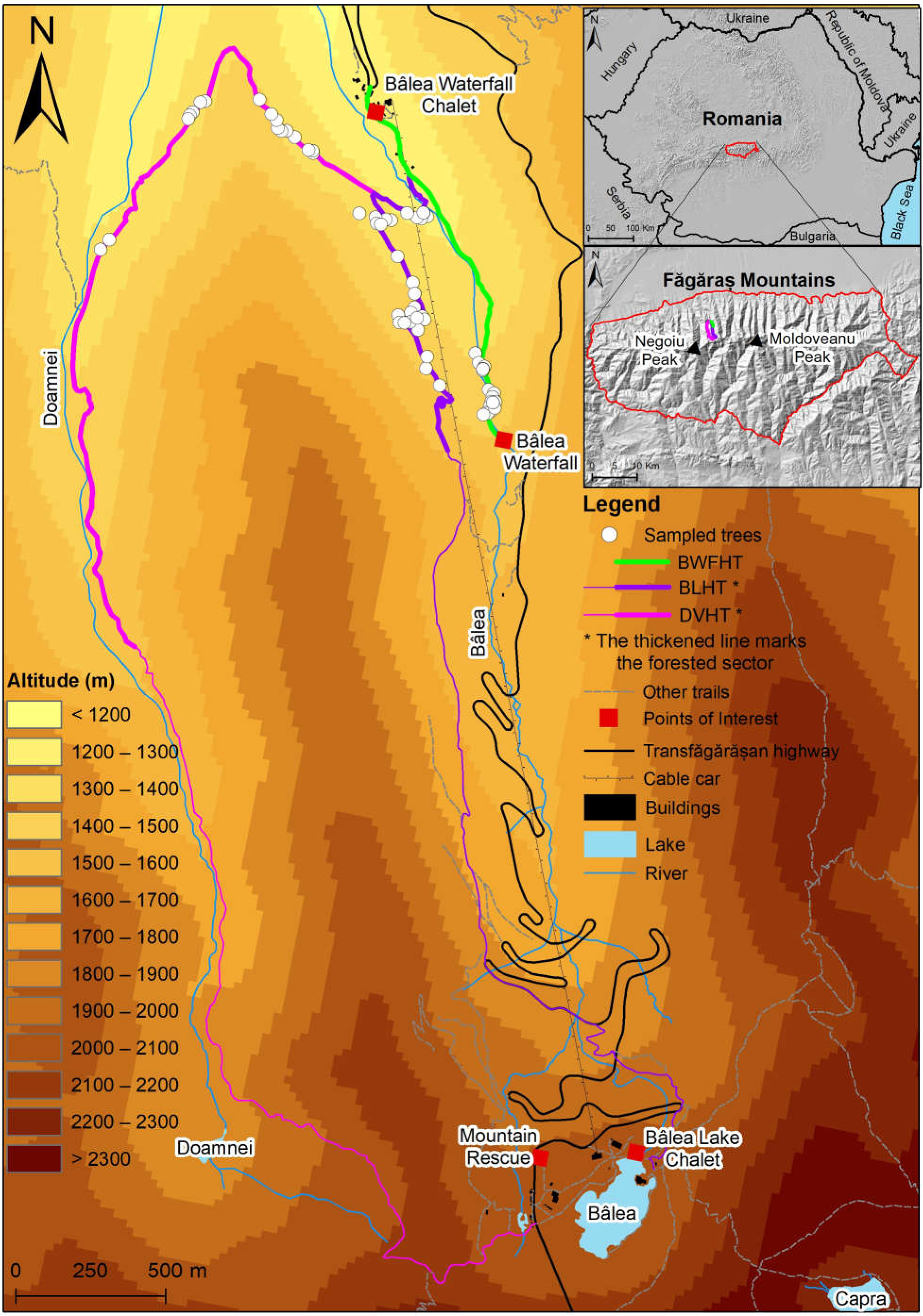
2.1. Study Area
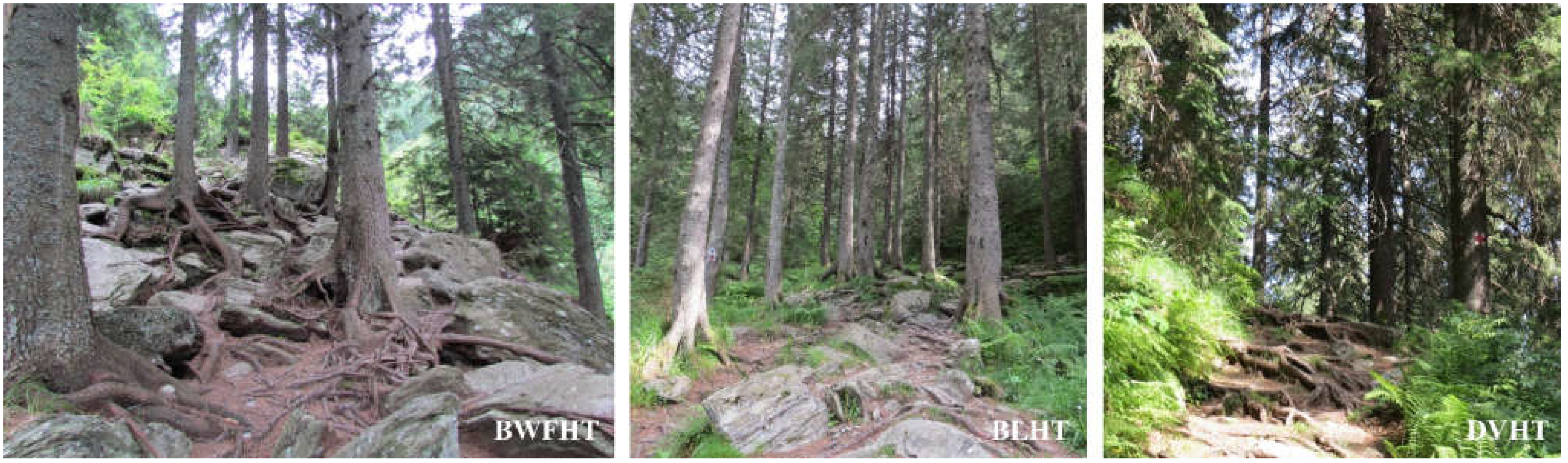
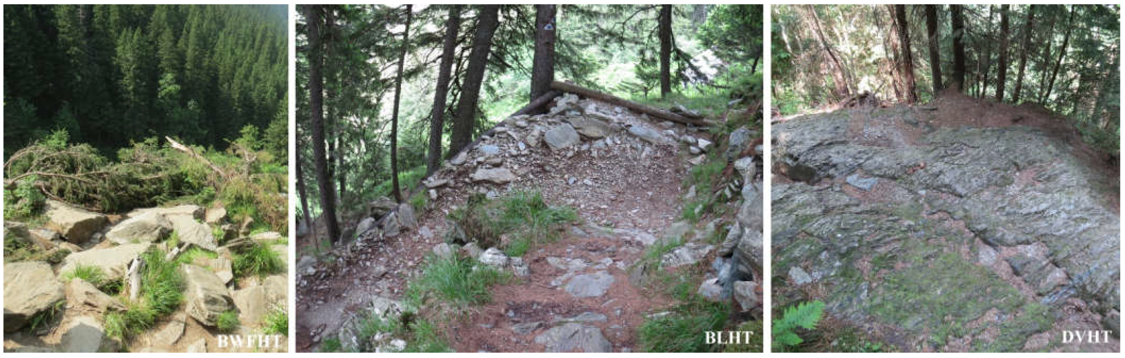
2.2. Hiking Trails
2.3. Sampling Strategy
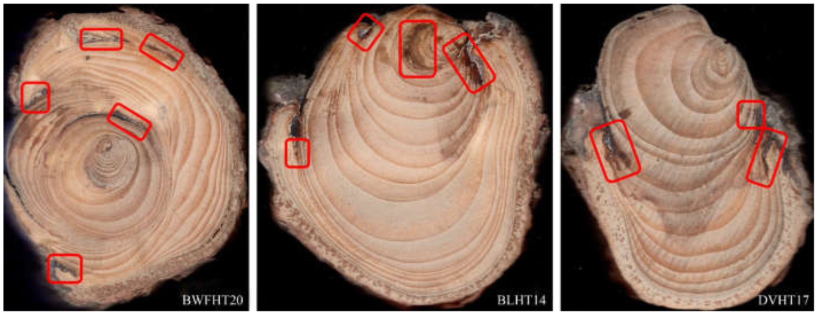
2.4. Sample Analysis
2.5. Characteristics of Trampling Scar and Scar Dating and TRD
2.6. Estimation of the Erosion Rate
3. Results
3.1. Root Characteristics
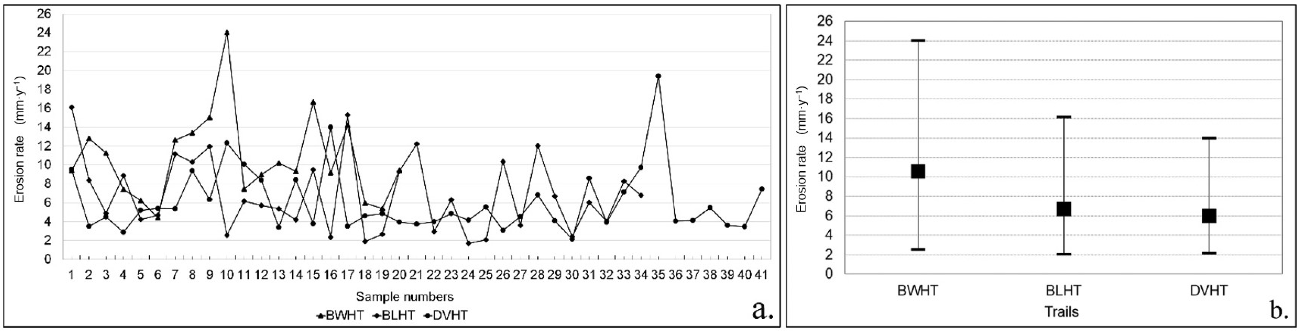
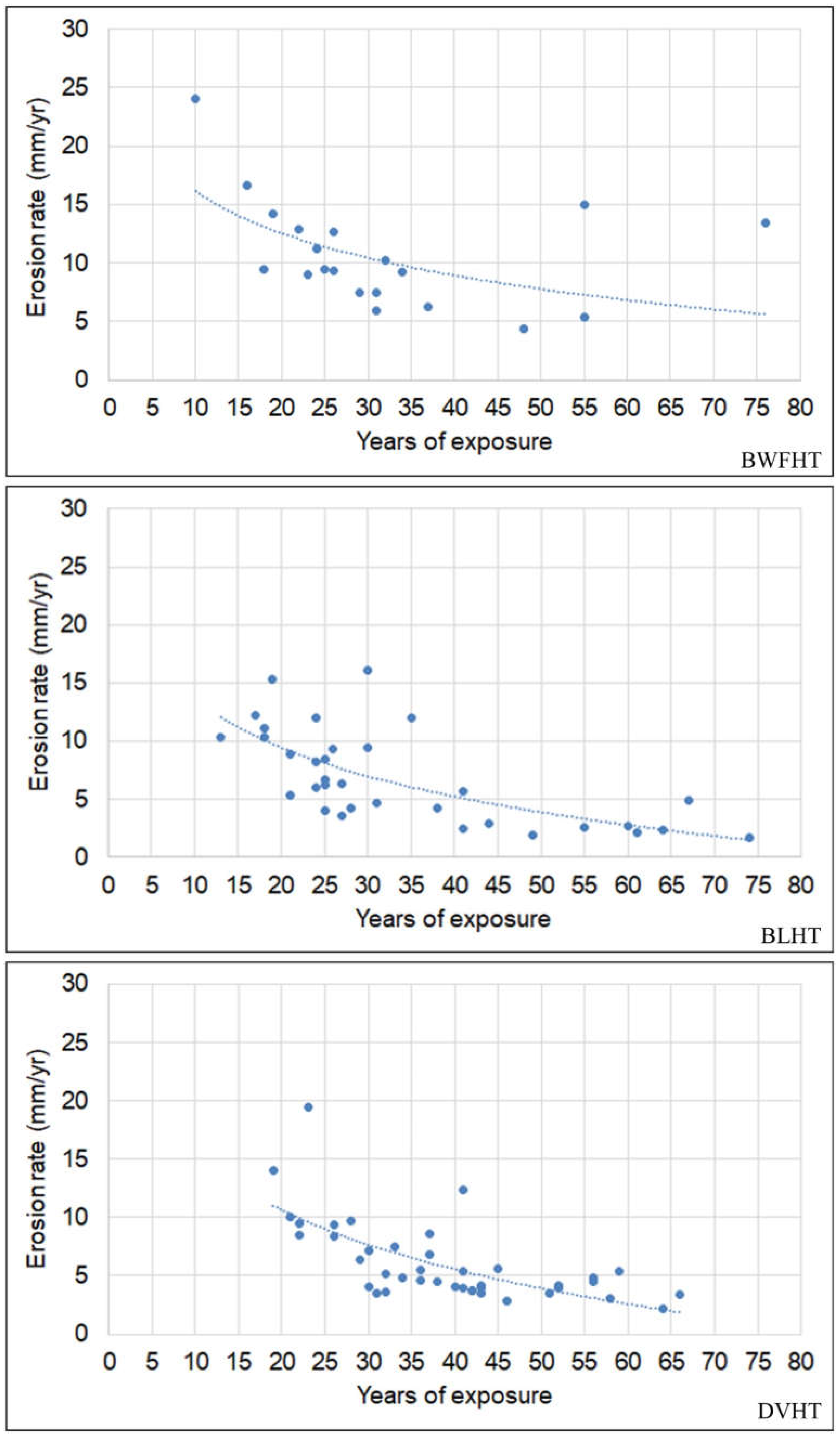
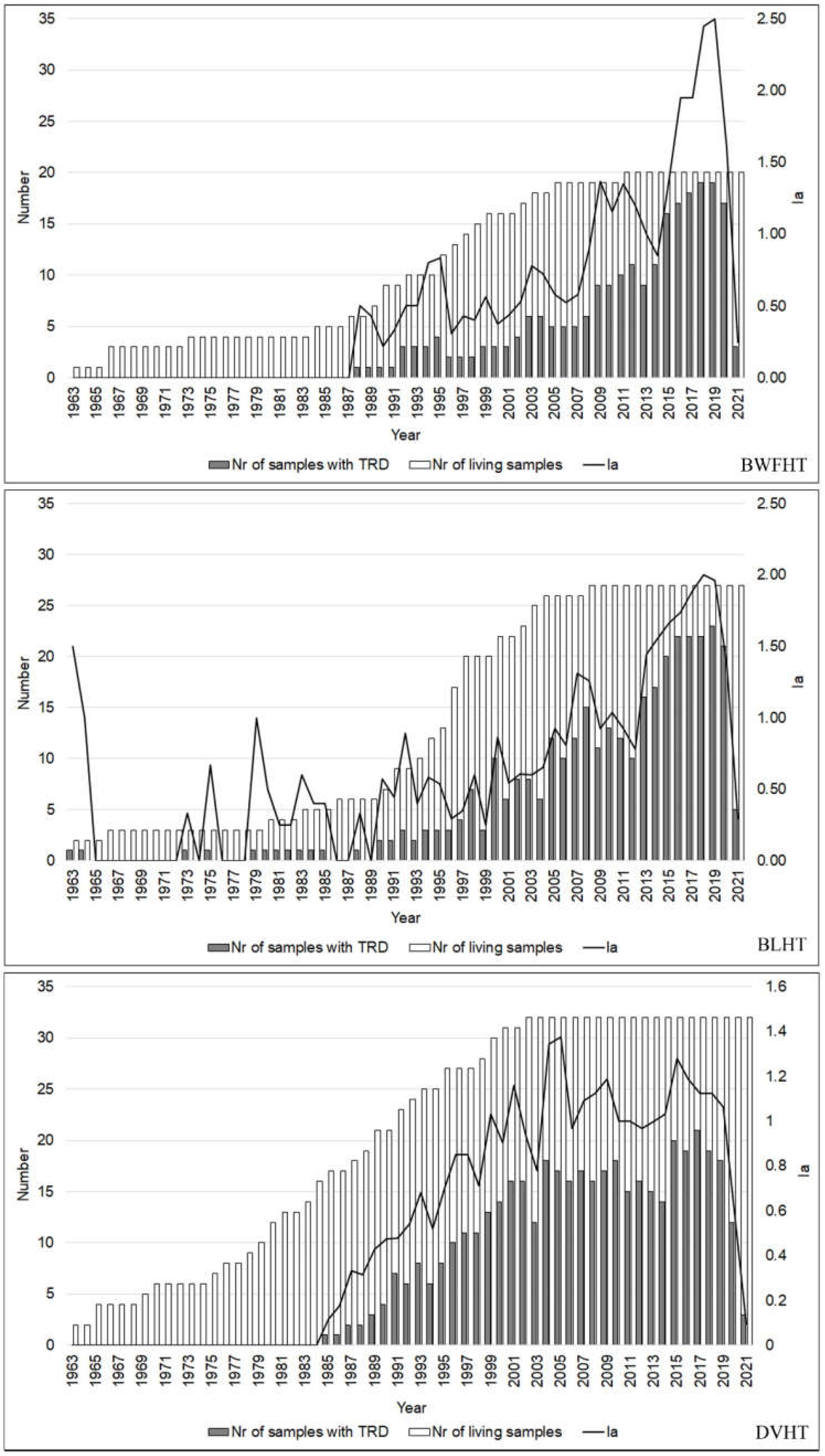
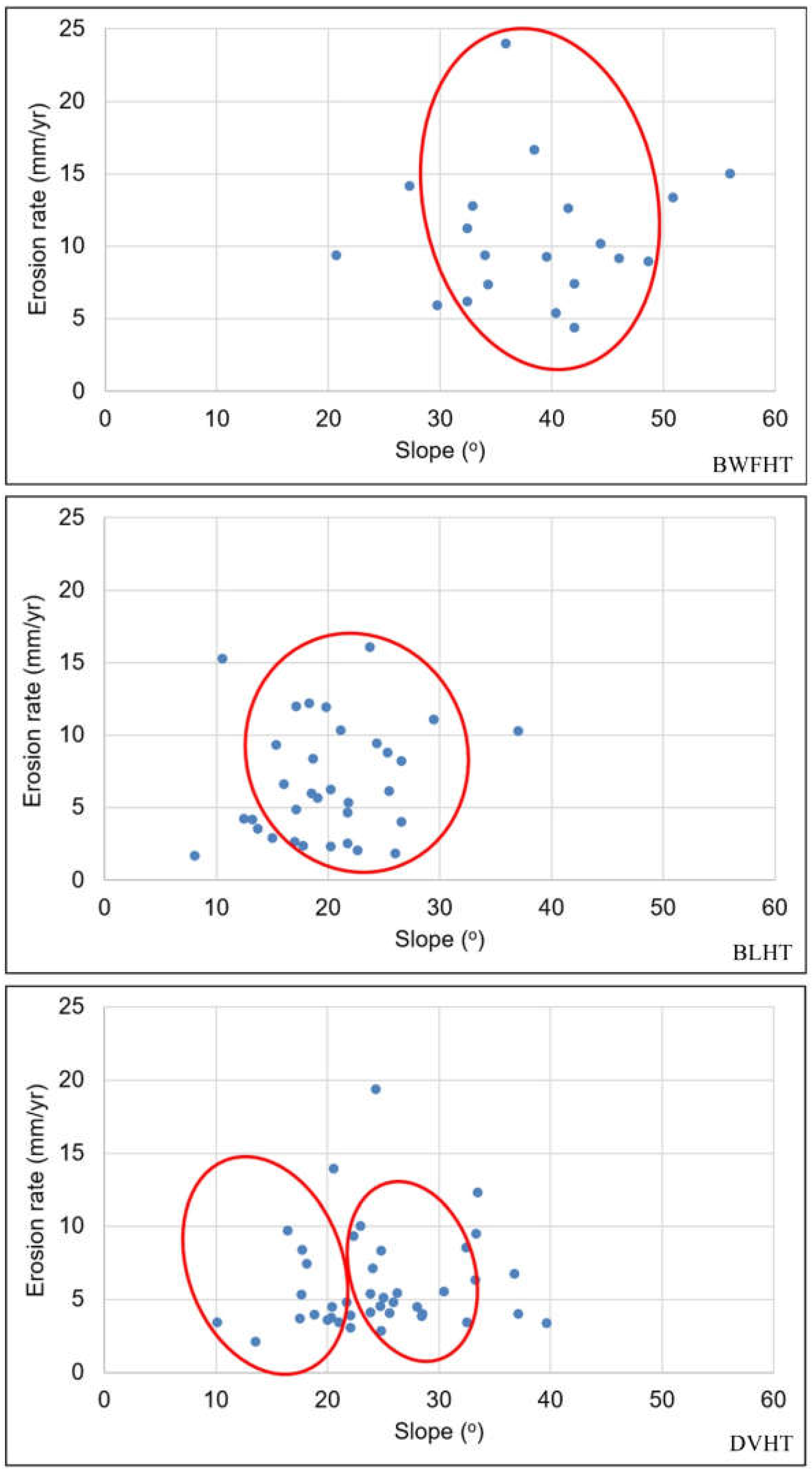
3.2. Erosion Rate and Root Exposure
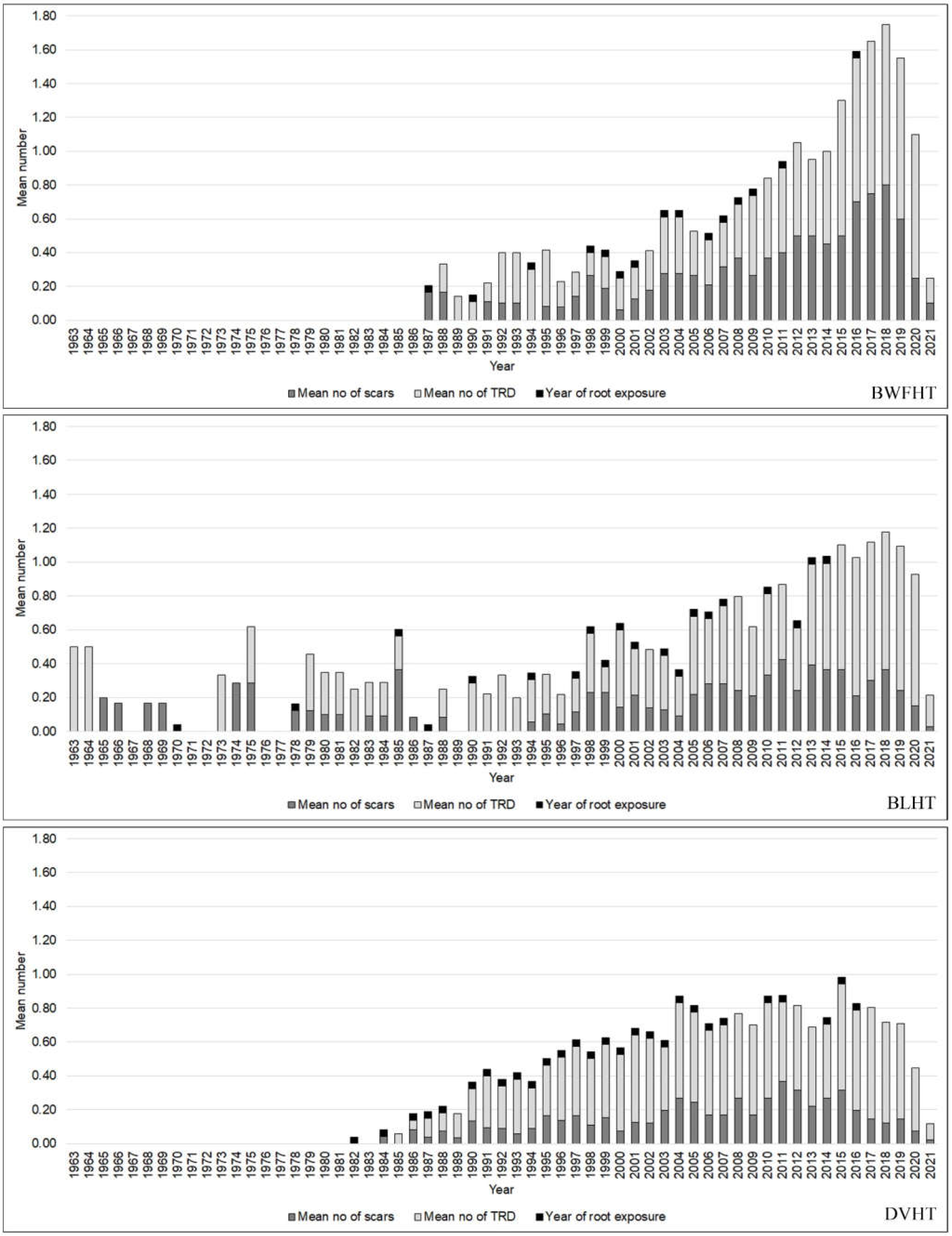
3.3. Scars and TRD Distribution
4. Discussions
5. Conclusions
Author Contributions
Funding
Data Availability Statement
Acknowledgments
Conflicts of Interest
References
- Buchwał, A. Dendrogeomorphological records of trail erosion. In Proceedings of the DENDROSYMPOSIUM 2008, Zakopane, Poland, 27–30 April 2008; pp. 166–170. [Google Scholar]
- Gärtner, H.; Schweingruber, F.H.; Dikau, R. Determination of erosion rates by analyzing structural changes in the growth pattern of exposed roots. Dendrochronologia 2001, 19, 81–91. Available online: https://www.dora.lib4ri.ch/wsl/islandora/object/wsl:2853 (accessed on 10 November 2021).
- Gärtner, H.; Heinrich, I. The Formation of Traumatic Rows of Resin Ducts in Larix decidua and Picea abies (Pinaceae) as a Result of Wounding Experiments in the Dormant Season. IAWA J. 2009, 30, 199–215. [Google Scholar] [CrossRef] [Green Version]
- Hitz, O.M.; Gärtner, H.; Heinrich, I.; Monbaron, M. Application of ash (Fraxinus excelsior L.) roots to determine erosion rates in mountain torrents. Catena 2008, 72, 248–258. [Google Scholar] [CrossRef] [Green Version]
- Ciapała, S.; Adamski, P.; Zielonka, T. Tree ring analysis as an indicator of environmental changes caused by tourist trampling—A potential method for the assessment of the impact of tourists. Geochronometria 2014, 41, 392–399. [Google Scholar] [CrossRef] [Green Version]
- Matulewski, P.; Buchwal, A.; Zielonka, A.; Wrónska-Wałach, D.; Čufar, K.; Gärtner, H. Trampling as a major ecological factor affecting the radial growth and wood anatomy of Scots pine (Pinus sylvestris L.) roots on a hiking trail. Ecol. Indic. 2021, 121, 107095. [Google Scholar] [CrossRef]
- Pelfini, M.; Santilli, M. Dendrogeomorphological analyses on exposed roots along two mountain hiking trails in the Central Italian Alps. Geogr. Ann. 2006, 88, 223–236. [Google Scholar] [CrossRef]
- Querrec, L.; Filion, L. White-tailed deer activity reconstructed from tree-rings in eastern boreal Canada. For. Ecol. Manag. 2008, 255, 234–244. [Google Scholar] [CrossRef]
- Boudreau, S.; Payette, S.; Morneau, C.; Couturier, S. Decline of the George River Caribou Herd as Revealed by Tree-Ring Analysis. Arct. Antarct. Alp. Res. 2003, 35, 187–195. [Google Scholar] [CrossRef] [Green Version]
- Morneau, C.; Payette, S. A dendroecological method to evaluate past caribou (Rangifer tarandus L.) activity. Ecoscience 1998, 5, 64–76. [Google Scholar] [CrossRef]
- Morneau, C.; Payette, S. Long-term fluctuations of a caribou population revealed by tree-ring data. Can. J. Zool. 2000, 78, 1784–1790. [Google Scholar] [CrossRef]
- Zalatan, R.; Gunn, A.; Henry, G.H.R. Long-term Abundance Patterns of Barren-ground Caribou Using Trampling Scars on Roots of Picea mariana in the Northwest Territories, Canada. Arct. Antarct. Alp. Res. 2006, 38, 624–630. [Google Scholar] [CrossRef]
- Wrońska-Wałach, D. Dendrogeomorphological analysis of a headwater area in the Gorce Mountains. Stud. Geomorph. Carpatho-Balc. 2009, 63, 97–114. [Google Scholar]
- Wrońska-Wałach, D.; Gorczyca, E.; Sobucki, M.; Buchwał, A.; Korpak, J.; Wałdykowski, P. Quantitative analysis of secondary growth in spruce roots and its application for precise roots dating. Dendrochronologia 2014, 38, 61–71. [Google Scholar] [CrossRef]
- Gärtner, H. The applicability of roots in Dendrogeomorphology. TRACE Tree Rings Archaeol. Climatol. Ecol. 2003, 1, 120–124. [Google Scholar]
- Eissenstat, D.M.; Mitchell, J.E.; Pope, W.W. Trampling damage by cattle on northern Idaho forest plantations. J. Range Manag. 1982, 35, 715–716. [Google Scholar] [CrossRef]
- Stoffel, M. Dating past geomorphic processes with tangential rows of traumatic resin ducts. Dendrochronologia 2008, 26, 53–60. [Google Scholar] [CrossRef] [Green Version]
- Matulewski, P.; Buchwal, A.; Makohonienko, M. Higher climatic sensitivity of Scots pine (Pinus sylvestris L.) subjected to tourist pressure on a hiking trail in the Brodnica Lakeland, NE Poland. Dendrochronologia 2019, 54, 78–86. [Google Scholar] [CrossRef]
- Stoffel, M.; Corona, C.; Ballesteros-Cánovas, J.A.; Bodoque, M.J. Dating and quantification of erosion processes based on exposed roots. Earth-Sci. Rev. 2013, 123, 18–34. [Google Scholar] [CrossRef]
- DeRose, J.R.; Bekker, F.M.; Long, N.J. Traumatic resin ducts as indicators of bark beetle outbreaks. Can. J. For. Res. 2017, 47, 1168–1174. [Google Scholar] [CrossRef]
- Ferrenberg, S.; Kane, J.M.; Mitton, J.B. Resin duct characteristics associated with tree resistance to bark beetles across lodgepole and limber pines. Oecologia 2014, 174, 1283–1292. [Google Scholar] [CrossRef]
- Franceschi, V.R.; Krokene, P.; Christiansen, E.; Krekling, T. Anatomical and chemical defenses of conifer bark against bark beetles and other pests. New Phytol. 2005, 167, 353–376. [Google Scholar] [CrossRef] [PubMed]
- López-Villamor, A.; Zas, R.; Pérez, A.; Cáceres, Y.; Nunes da Silva, M.; Vasconcelos, M.; Vázquez-González, C.; Sampedro, L.; Solla, A. Traumatic resin ducts induced by methyl jasmonate in Pinus spp. Trees 2021, 35, 557–567. [Google Scholar] [CrossRef]
- McKay, S.A.B.; Hunter, L.W.; Godard, K.-A.; Wang, X.S.; Martin, M.D.; Bohlmann, J.; Plant, L.A. Insect attack and wounding induce traumatic resin duct development and gene expression of (–)-pinene synthase in Sitka spruce. Plant Physiol. 2003, 133, 368–378. [Google Scholar] [CrossRef] [PubMed]
- Vázquez-González, C.; Zas, R.; Erbilgin, N.; Ferrenberg, S.; Rozas, V.; Sampedro, L. Resin ducts as resistance traits in conifers: Linking dendrochronology and resin-based defences. Tree Physiol. 2020, 7, 1313–1326. [Google Scholar] [CrossRef]
- Catherwood, A.A.; Knapp, A.P.; Mitchell, J.T. Scientific Note: Loblolly Pine Traumatic Resin Ducts Serve as Indicators of Cool-Season Weather Events at Nags Head, North Carolina. Castanea 2022, 86, 296–304. [Google Scholar] [CrossRef]
- Gaglioti, B.V.; Mann, D.H.; Williams, A.P.; Wiles, G.C.; Stoffel, M.; Oelkers, R.; Jones, B.M.; Andreu-Hayles, L. Traumatic resin ducts in subalpine mountain hemlock trees as a new proxy for past winter storminess. J. Geophys. Res. Biogeosciences 2019, 124, 1923–1938. [Google Scholar] [CrossRef]
- Öhrn, P.; Berlin, M.; Elfstrand, M.; Krokene, P.; Jönsson, A.M. Seasonal variation in Norway spruce response to inoculation with bark beetle-associated bluestain fungi one year after a severe drought. For. Ecol. Manag. 2021, 496, 119443. [Google Scholar] [CrossRef]
- Rigling, A.; Bräker, O.U.; Schneiter, G.; Schweingruber, F.H. Intra-annual tree-ring parameters indicating differences in drought stress of Pinus sylvestris forests within the Erico-Pinion in the Valais (Switzerland). Plant Ecol. 2002, 163, 105–121. [Google Scholar] [CrossRef] [Green Version]
- Rigling, A.; Brülhardt, H.; Bräker, O.U.; Forster, T.; Schweingruber, F.H. Effects of irrigation on diameter growth and vertical resin duct production in Pinus sylvestris L. on dry sites in the central Alps, Switzerland. For. Ecol. Manag. 2003, 175, 285–296. [Google Scholar] [CrossRef]
- Bollschweiler, M.; Stoffel, M.; Schneuwly, M.D.; Bourqui, K. Traumatic resin ducts in Larix decidua stems impacted by debris flows. Tree Physiol. 2008, 28, 255–263. [Google Scholar] [CrossRef]
- Schneuwly, M.D.; Stoffel, M.; Bollschweiler, M. Formation and spread of callus tissue and tangential rows of resin ducts in Larix decidua and Picea abies following rockfall impacts. Tree Physiol. 2009, 29, 281–289. [Google Scholar] [CrossRef] [Green Version]
- Bodoque, J.M.; Díez-Herrero, A.; Martín-Duque, J.F.; Rubiales, J.M.; Godfrey, A.; Pedraza, J.; Carrasco, R.M.; Sanz, M.A. Sheet erosion rates determined by using dendrogeomorphological analysis of exposed tree roots: Two examples from Central Spain. Catena 2005, 64, 81–102. [Google Scholar] [CrossRef] [Green Version]
- Bodoque, J.M.; Ballesteros-Canovas, J.A.; Rubiales, J.M.; Perucha, M.A.; Nadal-Romero, E.; Stoffel, M. Quantifying soil erosion from hiking trail in a protected natural area in the Spanish Pyrenees. Land Degrad. Dev. 2017, 28, 2255–2267. [Google Scholar] [CrossRef]
- Chartier, P.M.; Rostagno, M.C.; Roig, A.F. Soil erosion rates in rangelands of northeastern Patagonia: A dendrogeomorphological analysis using exposed shrub roots. Geomorphology 2009, 106, 344–351. [Google Scholar] [CrossRef]
- Chartier, P.M.; Giantomasi, A.M.; Renisona, D.; Roig, A.F. Exposed roots as indicators of geomorphic processes: A case-study from Polylepis mountain woodlands of Central Argentina. Dendrochronologia 2014, 37, 57–63. [Google Scholar] [CrossRef]
- Oven, D.; Levanič, T.; Jež, J.; Kobal, M. Reconstruction of Landslide Activity Using Dendrogeomorphological Analysis in the Karavanke Mountains in NW Slovenia. Forests 2019, 10, 1009. [Google Scholar] [CrossRef] [Green Version]
- Šilhán, K. Tree Ring-Based Estimation of Landslide Areal Reactivation as a Fundament of Magnitude–Frequency Assessment. Forests 2020, 11, 400. [Google Scholar] [CrossRef] [Green Version]
- Šilhán, K. Dendrogeomorphology of Different Landslide Types: A Review. Forests 2021, 12, 261. [Google Scholar] [CrossRef]
- LaMarche, V.C. Rate of slope erosion in the White Mountains, California. Geol. Soc. Am. Bull. 1961, 72, 1579–1580. [Google Scholar] [CrossRef]
- LaMarche, V.C. An 800-year history of stream erosion as indicated by botanical evidence. U.S. Geol. Surv. Prof. Pap. 1966, 550, 83–86. [Google Scholar]
- LaMarche, V.C. Rates of Slope Degradation as Determined from Botanical Evidence, White Mountains, California; US Government Printing Office: Washington, DC, USA, 1968; pp. 341–377.
- Alestalo, J. Dendrochronological interpretation of geomorphic processes. Fennia 1971, 105, 1–139. [Google Scholar]
- Carrara, P.E.; Carroll, T.R. The determination of erosion rates from exposed tree roots in the Piceance Basin, Colorado. Earth Surf. Process. 1979, 4, 307–317. [Google Scholar] [CrossRef]
- Vachon, M. Analyse dendroécologique de l’activité du caribou migrateur (Rangifer tarandus) à proximité des réservoirs hydroélectriques du complexe La Grande, Baie-James, Québec Subarctique. In Mémoire de Maîtrise; Département de Biologie, Faculté des Sciences et de Génie, Université Laval: Québec, QC, Canada, 2009; p. 52. [Google Scholar]
- Rubiales, J.M.; Bodoque, J.M.; Ballesteros, J.A.; Díez, A. Response of Pinus sylvestris roots to sheet-erosion exposure: An anatomical approach. Nat. Hazards Earth Syst. Sci. 2008, 8, 223–231. [Google Scholar] [CrossRef] [Green Version]
- Corona, C.; Lopez, J.; Rovéra, G.; Astrade, L.; Stoffel, M.; Berger, F. Quantification des vitesses d’érosion au moyen de raciness déchaussées: Validation de la méthode dans les badlands marneux des basins versants expérimentaux de Draix (Alpes de Haute-Provence). Géomorphologie Relief Process. Environ. 2011, 11, 83–94. Available online: https://boris.unibe.ch/id/eprint/10674 (accessed on 16 May 2022). [CrossRef] [Green Version]
- Stotts, S.V.; O’Neal, M.; Pizzuto, J.; Hupp, C. Exposed tree root analysis as a dendrogeomorphic approach to estimating bank retreat at the South River. Geomorphology 2014, 223, 10–18. [Google Scholar] [CrossRef]
- Zhang, Y.; Fang, K.; Zhou, F.; Dong, Z.; Li, Y.; Zhang, P. Reconstruction of soil erosion rates from exposed roots in southeast China. Asian Geogr. 2017, 34, 91–105. [Google Scholar] [CrossRef]
- Zhou, F.; Gou, X.; Zhang, J.; Zhao, Z.; Chen, Q.; Cao, Z. Application of Picea wilsonii roots to determine erosion rates in eastern Qilian Mountains, Northwest China. Trees 2013, 27, 371–378. [Google Scholar] [CrossRef]
- Evju, M.; Hagen, D.; Jokerud, M.; Olsen, L.S.; Selvaag, K.S.; Vistad, I.O. Effects of mountain biking versus hiking on trails under different environmental conditions. J. Environ. Manag. 2021, 278, 111554. [Google Scholar] [CrossRef]
- Mutanaa, S.; Mukwada, G. Mountain-route tourism and sustainability. A discourse analysis of literature and possible future research. J. Outdoor Recreat. Tour. 2018, 24, 59–65. [Google Scholar] [CrossRef]
- Pickering, C.M.; Hill, W.; Newsome, D.; Leung, Y.-F. Comparing hiking, mountain biking and horse riding impacts on vegetation and soils in Australia and the United States of America. J. Environ. Manag. 2010, 91, 551–562. [Google Scholar] [CrossRef]
- Svajda, J.; Korony, S.; Brighton, I.; Esser, S.; Ciapała, S. Trail impact monitoring in Rocky Mountain National Park, USA. Solid Earth 2016, 7, 115–128. [Google Scholar] [CrossRef] [Green Version]
- Boller, F.; Hunziker, M.; Conedera, M.; Elsasse, H.; Krebs, P. Fascinating Remoteness: The Dilemma of Hiking Tourism Development in Peripheral Mountain Areas. Mt. Res. Dev. 2010, 30, 320–331. [Google Scholar] [CrossRef]
- Kołodziejczyk, K. Networks of hiking tourist trails in the Krkonoše (Czech Republic) and Peneda-Gerês (Portugal) national parks—Comparative analysis. J. Mt. Sci. 2019, 16, 725–743. [Google Scholar] [CrossRef]
- Mokras-Grabowska, J. Mountain hiking in Tatra National Park. Tourism 2016, 26, 71–78. [Google Scholar] [CrossRef]
- Monz, C.A.; Pickering, C.M.; Hadwen, W.L. Recent advances in recreation ecology and the implications of different relationships between recreation use and ecological impacts. Front. Ecol. Environ. 2013, 11, 441–446. [Google Scholar] [CrossRef]
- Tomczyk, A.M.; Ewertowski, M. Degradation of recreational trails, Gorce National Park, Poland. J. Maps 2011, 7, 507–518. [Google Scholar] [CrossRef]
- Tomczyk, A.M.; Ewertowski, M. Quantifying short-term surface changes on recreational trails: The use of topographic surveys and ‘digital elevation models of differences’ (DODs). Geomorphology 2013, 183, 58–72. [Google Scholar] [CrossRef] [Green Version]
- Tomczyk, A.M.; Ewertowski, M. Planning of recreational trails in protected areas: Application of regression tree analysis and geographic information systems. Appl. Geogr. 2013, 40, 129–139. [Google Scholar] [CrossRef]
- Cole, D.N. Impacts of hiking and camping on soils and vegetation: A review. In Environmental Impacts of Ecotourism; Buckley, R., Ed.; CABI Publishing: New York, NY, USA, 2004; pp. 41–60. [Google Scholar]
- Dixon, G.; Hawes, M.; McPherson, G. Monitoring and modelling walking track impacts in the Tasmanian Wilderness World Heritage Area, Australia. J. Environ. Manag. 2004, 71, 305–320. [Google Scholar] [CrossRef]
- Farrell, T.A.; Marion, J.L. Trail impacts and trail impact management related to visitation at Torres del Paine National Park, Chile. Leisure 2002, 26, 31–59. [Google Scholar] [CrossRef]
- Goeft, U.; Alder, J. Sustainable Mountain Biking: A Case Study from the Southwest of Western Australia. J. Sustain. Tour. 2001, 9, 193–211. [Google Scholar] [CrossRef]
- Leung, Y.-F.; Marion, J.L. Assessing trail conditions in protected areas: Application of a problem assessment method in Great Smoky Mountains National Park, USA. Environ. Conserv. 1999, 26, 270–279. [Google Scholar] [CrossRef] [Green Version]
- Salesa, D.; Terol, E.; Cerdà, A. Soil erosion on the “El Portalet” mountain trails in the Eastern Iberian Peninsula. Sci. Total Environ. 2019, 661, 504–513. [Google Scholar] [CrossRef] [PubMed]
- Salesa, D.; Cerdà, A. Soil erosion on mountain trails as a consequence of recreational activities. A comprehensive review of the scientific literature. J. Environ. Manag. 2020, 271, 110990. [Google Scholar] [CrossRef]
- Li, W.; Liu, G.X. Hiking and tourism impact assessement in protected area: Jiuzhaigou Biosphere Reserve, China. Environ. Monit. Assess. 2005, 108, 279–293. [Google Scholar] [CrossRef]
- Meadema, F.; Marion, L.J.; Arredondo, J.; Wimpey, J. The influence of layout on Appalachian Trail soil loss, widening, and muddiness: Implications for sustainable trail design and management. J. Environ. Manag. 2020, 257, 109986. [Google Scholar] [CrossRef]
- Barros, A.; Gonnet, J.; Pickering, C. Impacts of informal trails on vegetation and soils in the highest protected area in the Southern Hemisphere. J. Environ. Manag. 2013, 127, 50–60. [Google Scholar] [CrossRef]
- Hill, W.; Pickering, C.M. Vegetation associated with different walking track types in the Kosciuszko alpine area, Australia. J. Environ. Manag. 2006, 78, 24–34. [Google Scholar] [CrossRef]
- Roovers, P.; Verheyen, K.; Hermy, M.; Gulinck, H. Experimental trampling and vegetation recovery in some forest and heathland communities. Appl. Veg. Sci. 2004, 7, 111–118. [Google Scholar] [CrossRef]
- Jula, M.; Voiculescu, M. Assessment of the mean erosion rate using dendrogeomorphological approaches on exposed roots along hiking and biking trails in the Bucegi Mountains, Romanian Carpathians. Catena 2022, 217, 106435. [Google Scholar] [CrossRef]
- Voiculescu, M. Studiul Potenţialului Geoecologic și Protecţia Mediului în Masivul Făgăraş; Mirton: Timișoara, Romania, 2002; p. 375. [Google Scholar]
- Kottek, M.; Grieser, J.; Beck, C.; Rudolf, B.; Rubel, F. World Map of the Köppen-Geiger climate classification updated. Meteorol. Z. 2006, 15, 259–263. [Google Scholar] [CrossRef]
- Sturm, M.; Holmgren, J.; Liston, E.G. A Seasonal Snow Cover Classification System for Local to Global Applications. J. Clim. 1995, 8, 1261–1283. [Google Scholar] [CrossRef]
- Ballesteros-Cánovas, J.A.; Corona, C.; Stoffel, M.; Lucia-Vela, A.; Bodoque, J.M. Combining terrestrial laser scanning and root exposure to estimate erosion rates. Plant Soil 2015, 394, 127–137. [Google Scholar] [CrossRef]
- Bodoque, J.M.; Ballesteros-Cánovas, J.A.; Lucía, A.; Díez-Herrero, A.; MartínDuque, J.F. Source of error and uncertainty in sheet erosion rates estimated from dendrogeomorphology. Earth Surf. Process. Landf. 2015, 40, 1146–1157. [Google Scholar] [CrossRef]
- Ferguson, J.Y. Location and Design of Recreational Trails: Application of GIS Technology; Virginia Polytechnic Institute and State University: Blacksburg, VA, USA, 1998. [Google Scholar]
- Florea, M. Munţii Făgăraşului. Studiu Geomorfologic; Foton: Brașov, Romania, 1998; p. 114. [Google Scholar]
- Spirescu, M.; Bălăceanu, V. Solurile Munţilor Făgăraş. In Comunicări de Botanică, A X-a Consfătuire Naţională de Botanică; Universitatea din Bucureşti: Bucureşti, Romania, 1977; pp. 87–95. [Google Scholar]
- Bernatek-Jakiel, A.; Wrońska-Wałach, D. Impact of piping on gully development in mid-altitude mountains under a temperate climate: A dendrogeomorphological approach. Catena 2018, 165, 320–332. [Google Scholar] [CrossRef]
- Lopez Saez, J.; Corona, C.; Stoffel, M.; Rovéra, G.; Astrade, L.; Berger, F. Mapping of erosion rates in marly badlands based on a coupling of anatomical changes in exposed roots with slope maps derived from LiDAR data. Earth Surf. Process. Landf. 2011, 36, 1162–1171. [Google Scholar] [CrossRef]
- Fritts, C.H. Dendroclimatology and dendroecology. Quat. Res. 1971, 1, 419–449. [Google Scholar] [CrossRef]
- Malik, I.; Pawlik, Ł.; Ślęzak, A.; Wistuba, M. A study of the wood anatomy of Picea abies roots and their role in biomechanical weathering of rock cracks. Catena 2019, 173, 264–275. [Google Scholar] [CrossRef]
- Gärtner, H. Tree roots. Methodological review and new development in dating and quantifying erosive processes. Geomorphology 2007, 86, 243–251. [Google Scholar] [CrossRef]
- Franco-Ramos, O.; Ballesteros-Cánovas, A.J.; Terrazas, T.; Stoffel, M.; Vázquez-Selem, L.; Cerano-Paredes, J. Reconstruction of gully erosion based on exposed tree roots in a recent landform of Paricutin Volcano, Mexico. Earth Surf. Process. Landf. 2022, 47, 742–755. [Google Scholar] [CrossRef]
- Yoda, A.; Watanabe, T. Erosion of Mountain Hiking Trail Over a Seven-Year Period in 792 Daisetsuzan National Park, Central Hokkaido, Japan. In Proceedings of the Wilderness Science in a Time of Change Conference, Missoula, MT, USA, 23–27 May 1999; pp. 172–178. [Google Scholar]
- Bratton, S.P.; Hickler, M.G.; Graves, J.H. Trail erosion patterns in Great Smoky Mountains National Park. Environ. Manag. 1979, 3, 431–445. [Google Scholar] [CrossRef]
- Marion, J.L.; Leung, Y.-F. Trail Resource Impacts and An Examination of Alternative Assessment Techniques. J. Park Recreat. Adm. 2001, 19, 17–37. [Google Scholar]
- Leung, Y.-F.; Marion, J.L. Trail degradation as influenced by environmental factors: A state-of-the-knowledge review. J. Soil Water Conserv. 1996, 51, 130–136. [Google Scholar]
- Ólafsdóttir, R.; Runnström, C.M. Assessing hiking trails condition in two popular tourist destinations in the Icelandic highlands. J. Outdoor Recreat. Tour. 2013, 3, 57–67. [Google Scholar] [CrossRef]
- DiBiase, A.R.; Whipple, X.K.; Heimsath, M.A.; Ouimet, B.W. Landscape form and millennial erosion rates in the San Gabriel Mountains. Earth Planet. Sci. Lett. 2010, 289, 134–144. [Google Scholar] [CrossRef]
- Montgomery, R.D.; Brandon, T.M. Topographic controls on erosion rates in tectonically active mountain ranges. Earth Planet. Sci. Lett. 2002, 201, 481–489. [Google Scholar] [CrossRef]
- Schweingruber, F.H. Tree Rings: Basics and Applications of Dendrochronology; Reidel: Boston, MA, USA, 1988; p. 276. [Google Scholar]
- Malik, I.; Matyja, M. Bank erosion history of a mountain stream determined by means of anatomical changes in exposed tree roots over the last 100 years (Bila Opava River—Czech Republic). Geomorphology 2008, 98, 126–142. [Google Scholar] [CrossRef]
- Malik, I. Gully erosion dating by means of anatomical changes in exposed roots (Proboszczowicka Plateau, Southern Poland). Geochronometria 2006, 25, 57–66. [Google Scholar]
- Malik, I. Dating of small gully formation and establishing erosion rates in old gullies under forest by means of anatomical changes in exposed tree roots (Southern Poland). Geomorphology 2008, 93, 421–436. [Google Scholar] [CrossRef]
- Malik, I.; Wistuba, M. Dendrochronological methods for reconstructing mass movements—An example of landslide activity analysis using tree-ring eccentricity. Geochronometria 2012, 39, 180–196. [Google Scholar] [CrossRef] [Green Version]
- Wistuba, M.; Malik, I.; Wójcicki, K.; Michałowicz, P. Coupling between landslides and eroding stream channels reconstructed from spruce tree rings (examples from the Carpathians and Sudetes—Central Europe). Earth Surf. Process. Landf. 2015, 40, 293–312. [Google Scholar] [CrossRef]
- Grissino-Mayer, H.D. Dendrochronology. In McGraw-Hill Encyclopedia of Science and Technology, 9th ed.; McGraw-Hill Professional Publishing Group: New York, NY, USA, 2002; pp. 352–356. [Google Scholar]
- Bovi, C.R.; Chartier, P.M.; Roig, A.F.; Filho, T.M.; Castillo, D.V.; Cooper, M. Dynamics of erosion processes in the tropics: A dendrogeomorphological approach in an Ultisol of southeastern Brazil. Plant Soil 2019, 443, 369–386. [Google Scholar] [CrossRef]
- Piacentini, T.; Galli, A.; Marsala, V.; Miccadei, E. Analysis of Soil Erosion Induced by Heavy Rainfall: A Case Study from the NE Abruzzo Hills Area in Central Italy. Water 2018, 10, 1314. [Google Scholar] [CrossRef] [Green Version]
- Starkel, L. Geomorphic hazards in the Polish Flysch Carpathians. Stud. Geomorphol. Carpatho-Balc. 2006, 40, 7–19. [Google Scholar]
- Starkel, L. Searching for regularities of slope modelling by extreme events (diversity of rainfall intensity–duration and physical properties of the substrate). Landf. Anal. 2012, 21, 27–34. [Google Scholar] [CrossRef]
- García-Ruiz, M.J.; Arnáez, J.; White, M.S.; Lorente, A. Uncertainty assessment in the prediction of extreme rainfall events: An example from the central Spanish Pyrenees. Hydrol. Process. 2000, 14, 887–898. [Google Scholar] [CrossRef]
- Stăncescu, M.; Milian, N. Heavy precipitation in the Făgăraş Mountains. In Proceedings of the Aerul si Apa. Componente ale Mediului, Cluj-Napoca, Romania, 1–4 June 1988; pp. 265–272. [Google Scholar]
- Keesstra, S.; Nunes, P.J.; Saco, P.; Parsons, T.; Poeppl, R.; Masselink, R.; Cerdà, A. The way forward: Can connectivity be useful to design better measuring and modelling schemes for water and sediment dynamics? Sci. Total Environ. 2018, 644, 1557–1572. [Google Scholar] [CrossRef]
- Beniston, M.; Haeberli, W. Sensitivity of mountain regions to climatic change. In Climate of the 21st Century: Changes and Risks; Lozan, J.L., Grassl, H., Hupfer, P., Eds.; GEO Publications: Hamburg, Germany, 2001; pp. 237–244. [Google Scholar]
- Beniston, M. Climatic change in mountain regions: A review of possible impacts. Clim. Change 2003, 59, 5–31. [Google Scholar] [CrossRef]
- Kohler, T.; Giger, M.; Hurni, H.; Ott, C.; Wiesmann, U.; Wymann von Dach, S.; Maselli, D. Mountains and Climate Change: A Global Concern. Mt. Res. Dev. 2010, 30, 53–55. [Google Scholar] [CrossRef]


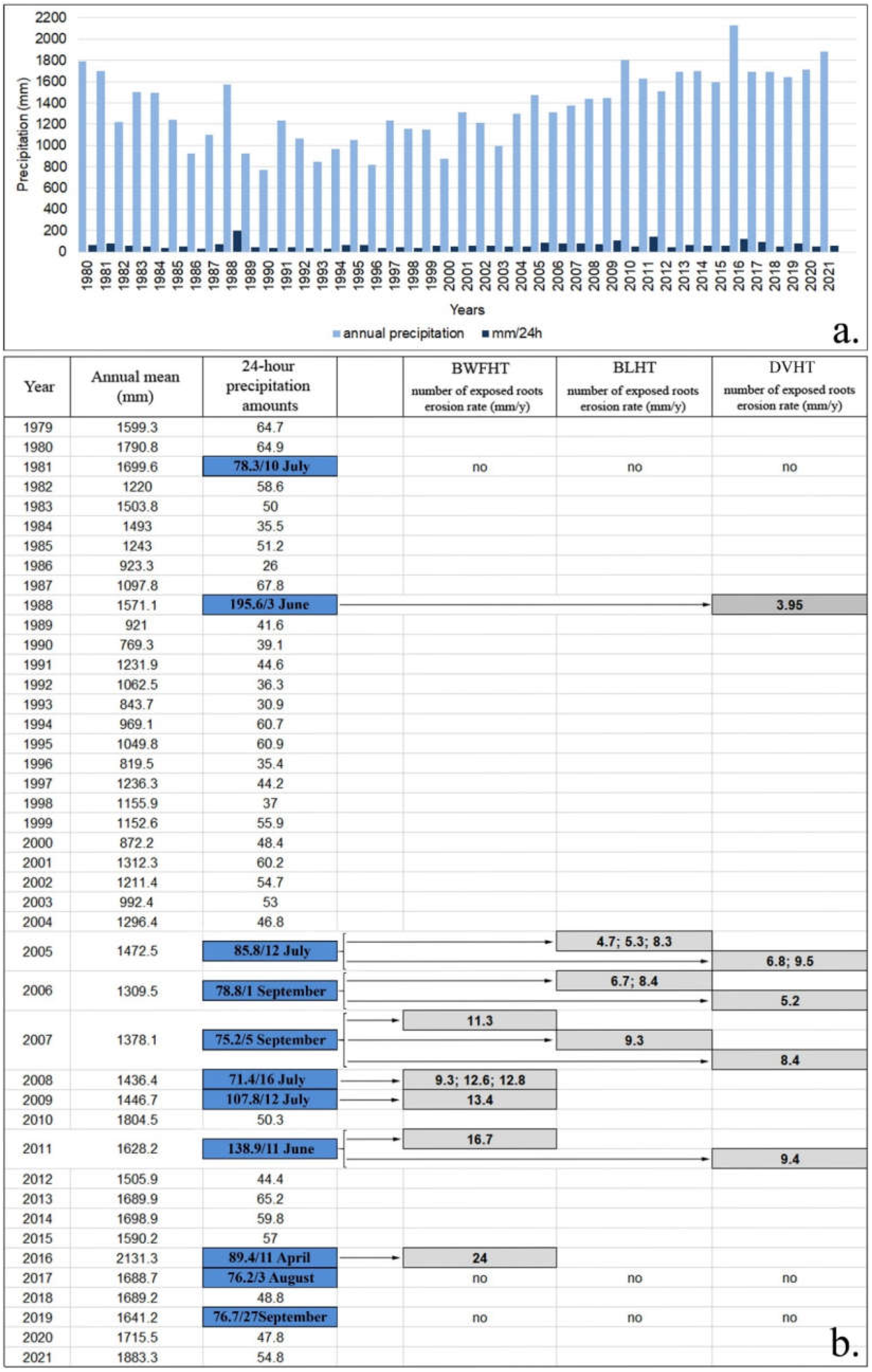
| Name/Code | Starting Point (m) | Arrival Point (m) | Vertical Drop (m) | Length (m) | Width (m) | Difficulty |
|---|---|---|---|---|---|---|
| Bâlea Hotel-Bâlea waterfall/BWHT | 1234 45°38′10.903″ N 24°36′23.227″ E | 1430 45°36′10.199″ N 24°36′49.312″ E | 196 | 1367 | 1.2–1.5 | medium-high |
| Bâlea Hotel-Bâlea Lake/BLHT | 1560 45°37′31.4184″ N 24°36′37.6956″ E | 326 | 1972—forested | 1.5–2 | low-medium | |
| Bâlea Hotel-Doamnei glacial valley/DVHT | 1580 45°37′25.2264″ N 24°35′40.596″ E | 346 | 3767—forested | 1–1.5 | low-medium |
| Sample Code | Root Age (years) | First Year of Exposure | Age of Exposure | Diameter (mm) | Ex (mm) | Era (mm·y−1) |
|---|---|---|---|---|---|---|
| BWFHT1 | 18 | 2013 | 8 | 47.88 | 20 | 9.41 |
| BWFHT2 | 22 | 2008 | 13 | 65.76 | 95 | 12.83 |
| BWFHT3 | 24 | 2007 | 14 | 65.73 | 80 | 11.25 |
| BWFHT4 | 29 | 1999 | 22 | 57.37 | 90 | 7.41 |
| BWFHT5 | 37 | 1994 | 27 | 50.55 | 120 | 6.24 |
| BWFHT7 | 48 | 1987 | 34 | 54.81 | 110 | 4.40 |
| BWFHT8 | 26 | 2008 | 13 | 53.44 | 100 | 12.64 |
| BWFHT9 | 76 | 2009 | 12 | 52.47 | 110 | 13.42 |
| BWFHT10 | 55 | 2004 | 17 | 53.86 | 200 | 15.04 |
| BWFHT11 | 10 | 2016 | 5 | 47.51 | 70 | 24.04 |
| BWFHT12 | 31 | 1999 | 22 | 61.98 | 90 | 7.45 |
| BWFHT13 | 23 | 2004 | 17 | 62.71 | 90 | 8.97 |
| BWFHT14 | 32 | 1998 | 23 | 68.1 | 175 | 10.21 |
| BWFHT15 | 26 | 2008 | 13 | 49.44 | 60 | 9.33 |
| BWFHT16 | 16 | 2011 | 10 | 42.63 | 120 | 16.66 |
| BWFHT17 | 34 | 2001 | 20 | 59.23 | 120 | 9.18 |
| BWFHT18 | 19 | 2009 | 12 | 50.94 | 110 | 14.21 |
| BWFHT19 | 31 | 2000 | 21 | 45.71 | 75 | 5.96 |
| BWFHT20 | 55 | 1990 | 31 | 75.37 | 130 | 5.42 |
| BWFHT21 | 25 | 2006 | 15 | 60.63 | 80 | 9.42 |
| Mean | 31.8± 15.4 | - | 17.5± 7 | 56.3± 8.2 | 102.3± 37.8 | 10.7± 4.5 |
| BLHT1 | 30 | 2010 | 11 | 53.11 | 140 | 16.12 |
| BLHT2 | 25 | 2006 | 15 | 46.71 | 70 | 8.40 |
| BLHT3 | 67 | 1990 | 31 | 61.43 | 110 | 4.89 |
| BLHT5 | 21 | 2010 | 11 | 41.27 | 60 | 8.86 |
| BLHT6 | 38 | 1998 | 23 | 41.02 | 50 | 4.24 |
| BLHT7 | 31 | 2005 | 16 | 41.04 | 30 | 4.68 |
| BLHT8 | 18 | 2010 | 11 | 47.32 | 60 | 11.14 |
| BLHT9 | 13 | 2014 | 7 | 38.28 | 20 | 10.32 |
| BLHT10 | 24 | 2012 | 9 | 30.75 | 60 | 11.97 |
| BLHT12 | 55 | 1978 | 43 | 54.79 | 60 | 2.55 |
| BLHT14 | 25 | 2004 | 17 | 52.14 | 40 | 6.18 |
| BLHT16 | 41 | 1994 | 27 | 59.82 | 100 | 5.70 |
| BLHT17 | 21 | 2005 | 16 | 42.6 | 35 | 5.38 |
| BLHT18 | 28 | 2000 | 21 | 45.2 | 30 | 4.19 |
| BLHT19 | 30 | 1999 | 22 | 55.18 | 140 | 9.48 |
| BLHT20 | 64 | 1987 | 34 | 52.24 | 40 | 2.36 |
| BLHT21 | 19 | 2012 | 9 | 41.13 | 90 | 15.32 |
| BLHT22 | 49 | 1985 | 36 | 38.67 | 20 | 1.89 |
| BLHT23 | 60 | 1985 | 36 | 42.13 | 40 | 2.67 |
| BLHT24 | 26 | 2007 | 14 | 42.01 | 70 | 9.34 |
| BLHT25 | 17 | 2013 | 8 | 46.58 | 40 | 12.22 |
| BLHT26 | 44 | 1997 | 24 | 43.26 | 20 | 2.93 |
| BLHT27 | 27 | 2001 | 20 | 62.19 | 60 | 6.30 |
| BLHT28 | 74 | 1959 | 62 | 44.68 | 50 | 1.71 |
| BLHT29 | 61 | 1970 | 51 | 64.89 | 40 | 2.09 |
| BLHT30 | 18 | 2012 | 9 | 43.34 | 40 | 10.35 |
| BLHT31 | 27 | 2003 | 18 | 32.3 | 30 | 3.59 |
| BLHT32 | 35 | 2013 | 8 | 46.56 | 50 | 12.01 |
| BLHT33 | 25 | 2006 | 15 | 79.89 | 60 | 6.67 |
| BLHT35 | 41 | 1990 | 31 | 41.39 | 40 | 2.42 |
| BLHT36 | 24 | 2004 | 17 | 41.26 | 60 | 6.04 |
| BLHT37 | 25 | 2000 | 21 | 44.37 | 40 | 4.04 |
| BLHT39 | 24 | 2005 | 16 | 64.63 | 80 | 8.27 |
| Mean | 34.2± 16 | - | 21.5± 12.8 | 47.9± 10.2 | 56.8± 29.9 | 6.8± 3.9 |
| DVHT1 | 22 | 2005 | 16 | 38.45 | 100 | 9.52 |
| DVHT2 | 31 | 2003 | 18 | 36.58 | 25 | 3.49 |
| DVHT3 | 38 | 1994 | 27 | 40.04 | 70 | 4.52 |
| DVHT4 | 46 | 1995 | 26 | 51.24 | 30 | 2.87 |
| DVHT5 | 32 | 2006 | 15 | 36.83 | 30 | 5.18 |
| DVHT6 | 41 | 1987 | 34 | 45.14 | 140 | 5.40 |
| DVHT7 | 59 | 1994 | 27 | 40.01 | 100 | 5.38 |
| DVHT8 | 26 | 2011 | 10 | 40.18 | 50 | 9.41 |
| DVHT9 | 29 | 2001 | 20 | 45.96 | 80 | 6.35 |
| DVHT10 | 41 | 2003 | 18 | 57.68 | 160 | 12.33 |
| DVHT11 | 21 | 2010 | 11 | 24.7 | 70 | 10.09 |
| DVHT12 | 26 | 2002 | 19 | 44.77 | 100 | 8.38 |
| DVHT13 | 66 | 1984 | 37 | 57.29 | 80 | 3.41 |
| DVHT14 | 22 | 2007 | 14 | 49.58 | 60 | 8.43 |
| DVHT15 | 42 | 1986 | 35 | 66.16 | 60 | 3.77 |
| DVHT17 | 19 | 2014 | 7 | 40.21 | 50 | 13.98 |
| DVHT18 | 43 | 1996 | 25 | 39.4 | 50 | 3.48 |
| DVHT19 | 36 | 1993 | 28 | 41.55 | 80 | 4.60 |
| DVHT20 | 34 | 2004 | 17 | 41.64 | 40 | 4.84 |
| DVHT21 | 43 | 1988 | 33 | 53.73 | 80 | 3.94 |
| DVHT22 | 42 | 1990 | 31 | 38.67 | 70 | 3.73 |
| DVHT23 | 41 | 1994 | 27 | 50.04 | 60 | 3.98 |
| DVHT24 | 56 | 1990 | 31 | 52.18 | 90 | 4.87 |
| DVHT25 | 52 | 1991 | 30 | 46.55 | 70 | 4.15 |
| DVHT26 | 45 | 2000 | 21 | 40.51 | 70 | 5.56 |
| DVHT28 | 58 | 1991 | 30 | 40.03 | 55 | 3.08 |
| DVHT29 | 56 | 1994 | 27 | 40.04 | 80 | 4.54 |
| DVHT30 | 37 | 2005 | 16 | 57.58 | 70 | 6.81 |
| DVHT31 | 30 | 2004 | 17 | 43.78 | 30 | 4.07 |
| DVHT32 | 64 | 1973 | 48 | 46.82 | 50 | 2.14 |
| DVHT33 | 37 | 1999 | 22 | 49.49 | 140 | 8.59 |
| VDHT35 | 52 | 1982 | 39 | 55.97 | 100 | 3.91 |
| DVHT36 | 30 | 2004 | 17 | 49.67 | 60 | 7.15 |
| DVHT37 | 28 | 2002 | 19 | 65.6 | 110 | 9.75 |
| DVHT38 | 23 | 2015 | 6 | 39.14 | 70 | 19.41 |
| DVHT39 | 40 | 1992 | 29 | 46.3 | 50 | 4.05 |
| DVHT40 | 43 | 1999 | 22 | 32.71 | 50 | 4.12 |
| DVHT41 | 36 | 1995 | 26 | 41.77 | 90 | 5.49 |
| DVHT42 | 32 | 1998 | 23 | 44.39 | 40 | 3.60 |
| DVHT43 | 51 | 1991 | 30 | 39.91 | 60 | 3.48 |
| DVHT44 | 33 | 1997 | 24 | 43 | 120 | 7.46 |
| Mean | 39.1± 11.9 | - | 23.7± 8.7 | 45.3± 8.2 | 72.9± 30 | 6.1± 3.4 |
Publisher’s Note: MDPI stays neutral with regard to jurisdictional claims in published maps and institutional affiliations. |
© 2022 by the authors. Licensee MDPI, Basel, Switzerland. This article is an open access article distributed under the terms and conditions of the Creative Commons Attribution (CC BY) license (https://creativecommons.org/licenses/by/4.0/).
Share and Cite
Jula, M.; Voiculescu, M. Assessment of the Annual Erosion Rate along Three Hiking Trails in the Făgăraș Mountains, Romanian Carpathians, Using Dendrogeomorphological Approaches of Exposed Roots. Forests 2022, 13, 1993. https://doi.org/10.3390/f13121993
Jula M, Voiculescu M. Assessment of the Annual Erosion Rate along Three Hiking Trails in the Făgăraș Mountains, Romanian Carpathians, Using Dendrogeomorphological Approaches of Exposed Roots. Forests. 2022; 13(12):1993. https://doi.org/10.3390/f13121993
Chicago/Turabian StyleJula, Mihai, and Mircea Voiculescu. 2022. "Assessment of the Annual Erosion Rate along Three Hiking Trails in the Făgăraș Mountains, Romanian Carpathians, Using Dendrogeomorphological Approaches of Exposed Roots" Forests 13, no. 12: 1993. https://doi.org/10.3390/f13121993