Essential Variables for Environmental Monitoring: What Are the Possible Contributions of Earth Observation Data Cubes?

 ,
,
Abstract
:1. Introduction
2. Methodology and Implementation
2.1. Essential Climate Variables
2.2. Essential Biodiversity Variables
2.3. Essential Water Variables
2.4. Implementation
3. Results
4. Discussion
5. Conclusions
Author Contributions
Funding
Acknowledgments
Conflicts of Interest
References
- World Economic Forum. The Global Risks Report 2020; WEF: Geneva, Switzerland, 2020; p. 102. [Google Scholar]
- Guerry, A.D.; Polasky, S.; Lubchenco, J.; Chaplin-Kramer, R.; Daily, G.C.; Griffin, R.; Ruckelshaus, M.; Bateman, I.J.; Duraiappah, A.; Elmqvist, T.; et al. Natural capital and ecosystem services informing decisions: From promise to practice. Proc. Natl. Acad. Sci. USA 2015, 112, 7348–7355. [Google Scholar] [CrossRef] [Green Version]
- Rockström, J.; Bai, X.; deVries, B. Global sustainability: The challenge ahead. Glob. Sustain. 2018, 1, e6. [Google Scholar] [CrossRef] [Green Version]
- Giuliani, G.; Mazzetti, P.; Santoro, M.; Nativi, S.; Van Bemmelen, J.; Colangeli, G.; Lehmann, A. Knowledge generation using satellite earth observations to support sustainable development goals (SDG): A use case on Land degradation. Int. J. Appl. Earth Obs. Geoinf. 2020, 88, 102068. [Google Scholar] [CrossRef]
- Curry, E. The big data value chain: Definitions, concepts, and theoretical approaches. In New Horizons for a Data-Driven Economy: A Roadmap for Usage and Exploitation of Big Data in Europe; Cavanillas, J.M., Curry, E., Wahlster, W., Eds.; Springer: Cham, Switzerland, 2016; pp. 29–37. ISBN 978-3-319-21569-3. [Google Scholar]
- Rowley, J. The wisdom hierarchy: Representations of the DIKW hierarchy. J. Inf. Sci. 2007, 33, 163–180. [Google Scholar] [CrossRef] [Green Version]
- Ackoff, R.L. From data to wisdom. In Ackoff’s Best; Sons, J.W., Ed.; John Wiley & Sons: New York, NY, USA, 1999; pp. 170–172. [Google Scholar]
- Nativi, S.; Santoro, M.; Giuliani, G.; Mazzetti, P. Towards a knowledge base to support global change policy goals. Int. J. Digit. Earth 2020, 13, 188–216. [Google Scholar] [CrossRef] [Green Version]
- Lehmann, A.; Chaplin-Kramer, R.; Lacayo, M.; Giuliani, G.; Thau, D.; Koy, K.; Goldberg, G. Lifting the Information Barriers to Address Sustainability Challenges with Data from Physical Geography and Earth Observation. Sustainability 2017, 9, 858. [Google Scholar] [CrossRef] [Green Version]
- Costanza, R.; Daly, L.; Fioramonti, L.; Giovannini, E.; Kubiszewski, I.; Mortensen, L.F.; Pickett, K.E.; Ragnarsdottir, K.V.; De Vogli, R.; Wilkinson, R. Modelling and measuring sustainable wellbeing in connection with the UN Sustainable Development Goals. Ecol. Econ. 2016, 130, 350–355. [Google Scholar] [CrossRef]
- Santoro, M.; Mazzetti, P.; Nativi, S. The VLab Framework: An Orchestrator Component to Support Data to Knowledge Transition. Remote. Sens. 2020, 12, 1795. [Google Scholar] [CrossRef]
- Cornell, S.; Berkhout, F.; Tuinstra, W.; Tabara, J.D.; Jager, J.; Chabay, I.; De Wit, B.; Langlais, R.; Mills, D.; Moll, P.; et al. Opening up knowledge systems for better responses to global environmental change. Environ. Sci. Policy 2013, 28, 60–70. [Google Scholar] [CrossRef] [Green Version]
- Reyers, B.; Stafford-Smith, M.; Erb, K.-H.; Scholes, R.J.; Selomane, O. Essential Variables help to focus Sustainable Development Goals monitoring. Curr. Opin. Environ. Sustain. 2017, 26–27, 97–105. [Google Scholar] [CrossRef]
- Lehmann, A.; Nativi, S.; Mazzetti, P.; Maso, J.; Serral, I.; Spengler, D.; Niamir, A.; McCallum, I.; Lacroix, P.; Patias, P.; et al. GEOEssential—Mainstreaming workflows from data sources to environment policy indicators with essential variables. Int. J. Digit. Earth 2019, 13, 322–338. [Google Scholar] [CrossRef] [Green Version]
- Lehmann, A.; Masò, J.; Nativi, S.; Giuliani, G. Towards integrated essential variables for sustainability. Int. J. Digit. Earth 2020, 13, 158–165. [Google Scholar] [CrossRef]
- Bojinski, S.; Verstraete, M.; Peterson, T.C.; Richter, C.; Simmons, A.; Zemp, M. The Concept of Essential Climate Variables in Support of Climate Research, Applications, and Policy. Bull. Am. Meteorol. Soc. 2014, 95, 1431–1443. [Google Scholar] [CrossRef]
- Giuliani, G.; Nativi, S.; Obregon, A.; Beniston, M.; Lehmann, A. Spatially enabling the Global Framework for Climate Services: Reviewing geospatial solutions to efficiently share and integrate climate data & information. Clim. Serv. 2017, 8, 44–58. [Google Scholar] [CrossRef]
- Espinosa, M.T.M.; Giuliani, G.; Ray, N. Reviewing the discoverability and accessibility to data and information products linked to Essential Climate Variables. Int. J. Digit. Earth 2019, 13, 236–252. [Google Scholar] [CrossRef]
- Pereira, H.M.; Ferrier, S.; Walters, M.; Geller, G.N.; Jongman, R.H.G.; Scholes, R.J.; Bruford, M.W.; Brummitt, N.; Butchart, S.H.M.; Cardoso, A.C.; et al. Essential Biodiversity Variables. Science 2013, 339, 277–278. [Google Scholar] [CrossRef] [Green Version]
- Geijzendorffer, I.R.; Regan, E.C.; Pereira, H.M.; Brotons, L.; Brummitt, N.; Gavish, Y.; Haase, P.; Martin, C.S.; Mihoub, J.-B.; Secades, C.; et al. Bridging the gap between biodiversity data and policy reporting needs: An Essential Biodiversity Variables perspective. J. Appl. Ecol. 2015, 53, 1341–1350. [Google Scholar] [CrossRef] [Green Version]
- Lawford, R.; Strauch, A.; Toll, D.; Fekete, B.; Cripe, D. Earth observations for global water security. Curr. Opin. Environ. Sustain. 2013, 5, 633–643. [Google Scholar] [CrossRef] [Green Version]
- Muller-Karger, F.E.; Miloslavich, P.; Bax, N.J.; Simmons, S.; Costello, M.J.; Sousa Pinto, I.; Canonico, G.; Turner, W.; Gill, M.; Montes, E.; et al. Advancing Marine Biological Observations and Data Requirements of the Complementary Essential Ocean Variables (EOVs) and Essential Biodiversity Variables (EBVs) Frameworks. Front. Mar. Sci. 2018, 5, 211. [Google Scholar] [CrossRef]
- Kussul, N.; Lavreniuk, M.; Kolotii, A.; Skakun, S.; Rakoid, O.; Shumilo, L. A workflow for Sustainable Development Goals indicators assessment based on high-resolution satellite data. Int. J. Digit. Earth 2019, 13, 309–321. [Google Scholar] [CrossRef]
- Patias, P.; Verde, N.; Tassopoulou, M.; Georgiadis, C.; Kaimaris, D. Essential variables: Describing the context, progress, and opportunities for the remote sensing community. In Proceedings of the Seventh International Conference on Remote Sensing and Geoinformation of the Environment (RSCy2019), Paphos, Cyprus, 18–21 March 2019; Volume 11174, p. 111740C. [Google Scholar]
- Ambrosone, M.; Giuliani, G.; Chatenoux, B.; Rodila, D.; Lacroix, P. Definition of candidate Essential Variables for the monitoring of mineral resource exploitation. Geo-Spat. Inf. Sci. 2019, 22, 265–278. [Google Scholar] [CrossRef] [Green Version]
- Shelestov, A.; Kolotii, A.; Borisova, T.; Turos, O.; Milinevsky, G.; Gomilko, I.; Bulanay, T.; Fedorov, O.; Shumilo, L.; Pidgorodetska, L.; et al. Essential variables for air quality estimation. Int. J. Digit. Earth 2020, 13, 278–298. [Google Scholar] [CrossRef]
- Ranchin, T.; Trolliet, M.; Ménard, L.; Wald, L. Which variables are essential for renewable energies? Int. J. Digit. Earth 2020, 13, 253–261. [Google Scholar] [CrossRef] [Green Version]
- Ehrlich, D.; Kemper, T.; Pesaresi, M.; Corbane, C. Built-up area and population density: Two Essential Societal Variables to address climate hazard impact. Environ. Sci. Policy 2018, 90, 73–82. [Google Scholar] [CrossRef]
- Masó, J.; Serral, I.; Domingo-Marimon, C.; Zabala, A. Earth observations for sustainable development goals monitoring based on essential variables and driver-pressure-state-impact-response indicators. Int. J. Digit. Earth 2020, 13, 217–235. [Google Scholar] [CrossRef] [Green Version]
- Dong, J.; Metternicht, G.; Hostert, P.; Fensholt, R.; Chowdhury, R.R. Remote sensing and geospatial technologies in support of a normative land system science: Status and prospects. Curr. Opin. Environ. Sustain. 2019, 38, 44–52. [Google Scholar] [CrossRef]
- Dhu, T.; Giuliani, G.; Juárez, J.; Kavvada, A.; Killough, B.; Merodio, P.; Minchin, S.; Ramage, S. National Open Data Cubes and Their Contribution to Country-Level Development Policies and Practices. Data 2019, 4, 144. [Google Scholar] [CrossRef] [Green Version]
- Kavvada, A.; Metternicht, G.; Kerblat, F.; Mudau, N.; Haldorson, M.; Laldaparsad, S.; Friedl, L.; Held, A.; Chuvieco, E. Towards delivering on the sustainable development goals using earth observations. Remote. Sens. Environ. 2020, 247, 111930. [Google Scholar] [CrossRef]
- Plag, H.-P.; Jules-Plag, S.-A. A goal-based approach to the identification of essential transformation variables in support of the implementation of the 2030 agenda for sustainable development. Int. J. Digit. Earth 2020, 13, 166–187. [Google Scholar] [CrossRef]
- Boulton, G. The challenges of a Big Data Earth. Big Earth Data 2018, 2, 1–7. [Google Scholar] [CrossRef]
- Guo, H. Big Earth data facilitates sustainable development goals. Big Earth Data 2020, 4, 1–2. [Google Scholar] [CrossRef]
- Kopp, S.; Becker, P.; Doshi, A.; Wright, D.J.; Zhang, K.; Xu, H. Achieving the Full Vision of Earth Observation Data Cubes. Data 2019, 4, 94. [Google Scholar] [CrossRef] [Green Version]
- Giuliani, G.; Camara, G.; Killough, B.; Minchin, S. Earth Observation Open Science: Enhancing Reproducible Science Using Data Cubes. Data 2019, 4, 147. [Google Scholar] [CrossRef] [Green Version]
- Baumann, P. Datacube standards and their contribution to analysis-ready data. In Proceedings of the IGARSS 2018—2018 IEEE International Geoscience and Remote Sensing Symposium, Valencia, Spain, 22–27 July 2018; pp. 2051–2053. [Google Scholar]
- Baumann, P.; Misev, D.; Merticariu, V.; Huu, B.P. Datacubes: Towards space/time analysis-ready data. In Service-Oriented Mapping; Lecture Notes in Geoinformation and Cartography; Springer: Cham, Switzerland, 2019; pp. 269–299. ISBN 978-3-319-72433-1. [Google Scholar]
- Ariza-Porras, C.; Bravo, G.; Villamizar, M.; Moreno, A.; Castro, H.; Galindo, G.; Cabera, E.; Valbuena, S.; Lozano, P. CDCol: A Geoscience Data Cube that Meets Colombian Needs; Springer: Cali, Colombia, 2017; pp. 87–99. [Google Scholar]
- Lewis, A.; Oliver, S.; Lymburner, L.; Evans, B.; Wyborn, L.; Mueller, N.; Raevksi, G.; Hooke, J.; Woodcock, R.; Sixsmith, J.; et al. The Australian Geoscience Data Cube—Foundations and lessons learned. Remote. Sens. Environ. 2017, 202, 276–292. [Google Scholar] [CrossRef]
- Killough, B. The impact of analysis ready data in the Africa regional data cube. In Proceedings of the IGARSS 2019—2019 IEEE International Geoscience and Remote Sensing Symposium, Yokohama, Japan, 28 July–2 August 2019; pp. 5646–5649. [Google Scholar]
- Asmaryan, S.; Muradyan, V.; Tepanosyan, G.; Hovsepyan, A.; Saghatelyan, A.; Astsatryan, H.; Grigoryan, H.; Abrahamyan, R.; Guigoz, Y.; Giuliani, G. Paving the Way towards an Armenian Data Cube. Data 2019, 4, 117. [Google Scholar] [CrossRef] [Green Version]
- Augustin, H.; Sudmanns, M.; Tiede, D.; Lang, S.; Baraldi, A. Semantic Earth Observation Data Cubes. Data 2019, 4, 102. [Google Scholar] [CrossRef] [Green Version]
- Gomes, V.C.F.; Queiroz, G.R.; Ferreira, K.R. An Overview of Platforms for Big Earth Observation Data Management and Analysis. Remote Sens. 2020, 12, 1253. [Google Scholar] [CrossRef] [Green Version]
- Bravo, G.; Castro, H.; Moreno, A.; Ariza-Porras, C.; Galindo, G.; Cabrera, E.; Valbuena, S.; Lozano-Rivera, P. Architecture for a Colombian Data Cube using satellite imagery for environmental applications. In Advances in Computing, Proceedings of the 12th Colombian Conference, Cali, Colombia, 19–22 September 2017; Springer: Cham, Switzerland, 2017; pp. 227–241. [Google Scholar]
- Giuliani, G.; Chatenoux, B.; Bono, A.D.; Rodila, D.; Richard, J.-P.; Allenbach, K.; Dao, H.; Peduzzi, P. Building an Earth Observations Data Cube: Lessons learned from the Swiss Data Cube (SDC) on generating Analysis Ready Data (ARD). Big Earth Data 2017, 1, 100–117. [Google Scholar] [CrossRef] [Green Version]
- Cheng, M.-C.; Chiou, C.-R.; Chen, B.; Liu, C.; Lin, H.-C.; Shih, I.-L.; Chung, C.-H.; Lin, H.-Y.; Chou, C.-Y. Open data cube (ODC) in Taiwan: The initiative and protocol development. In Proceedings of the IGARSS 2019—2019 IEEE International Geoscience and Remote Sensing Symposium, Yokohama, Japan, 28 July–2 August 2019; pp. 5654–5657. [Google Scholar]
- Ostensen, O.; O’Brien, D.; Cooper, A. Measurements to know and understand our world. ISO Focus 2008, 5, 35–37. [Google Scholar]
- Diamond, H.J.; Lief, C.J. A Comprehensive Data Portal for Global Climate Information. Eos Trans. AGU 2009, 90, 341–342. [Google Scholar] [CrossRef] [Green Version]
- Overpeck, J.T.; Meehl, G.A.; Bony, S.; Easterling, D.R. Climate Data Challenges in the 21st Century. Science 2011, 331, 700–702. [Google Scholar] [CrossRef] [PubMed]
- Street, R.B. Towards a leading role on climate services in Europe: A research and innovation roadmap. Clim. Serv. 2015, 1, 2–5. [Google Scholar] [CrossRef] [Green Version]
- Maggioni, V.; Meyers, P.C.; Robinson, M.D. A Review of Merged High-Resolution Satellite Precipitation Product Accuracy during the Tropical Rainfall Measuring Mission (TRMM) Era. J. Hydrometeor. 2016, 17, 1101–1117. [Google Scholar] [CrossRef]
- Huang, G.; Li, Z.; Li, X.; Liang, S.; Yang, K.; Wang, D.; Zhang, Y. Estimating surface solar irradiance from satellites: Past, present, and future perspectives. Remote Sens. Environ. 2019, 233, 111371. [Google Scholar] [CrossRef]
- Chelton, D.B.; Hussey, K.J.; Parke, M.E. Global satellite measurements of water vapour, wind speed and wave height. Nature 1981, 294, 529–532. [Google Scholar] [CrossRef]
- Jin, M.; Dickinson, R.E. Land surface skin temperature climatology: Benefitting from the strengths of satellite observations. Environ. Res. Lett. 2010, 5, 044004. [Google Scholar] [CrossRef] [Green Version]
- Barkstrom, B.R.; Smith, G.L. The Earth Radiation Budget Experiment: Science and implementation. Rev. Geophys. 1986, 24, 379–390. [Google Scholar] [CrossRef]
- Turman, B.N. Analysis of lightning data from the DMSP satellite. J. Geophys. Res. Ocean. 1978, 83, 5019–5024. [Google Scholar] [CrossRef]
- Spencer, R.W.; Christy, J.R. Precise Monitoring of Global Temperature Trends from Satellites. Science 1990, 247, 1558–1562. [Google Scholar] [CrossRef] [Green Version]
- Bhatia, R.C.; Bhushan, B.; Rao, V.R. Applications of water-vapour imagery received from INSAT-2E satellite. Curr. Sci. 1999, 76, 1448–1450. [Google Scholar]
- Wielicki, B.A.; Welch, R.M. Cumulus Cloud Properties Derived Using Landsat Satellite Data. J. Climate Appl. Meteorol. 1986, 25, 261–276. [Google Scholar] [CrossRef] [Green Version]
- Torres, O.; Bhartia, P.K.; Herman, J.R.; Ahmad, Z.; Gleason, J. Derivation of aerosol properties from satellite measurements of backscattered ultraviolet radiation: Theoretical basis. J. Geophys. Res. Atmos. 1998, 103, 17099–17110. [Google Scholar] [CrossRef]
- Kuze, A.; Suto, H.; Nakajima, M.; Hamazaki, T. Thermal and near infrared sensor for carbon observation Fourier-transform spectrometer on the Greenhouse Gases Observing Satellite for greenhouse gases monitoring. Appl. Opt. 2009, 48, 6716–6733. [Google Scholar] [CrossRef] [PubMed]
- Fishman, J.; Watson, C.E.; Larsen, J.C.; Logan, J.A. Distribution of tropospheric ozone determined from satellite data. J. Geophys. Res. Atmos. 1990, 95, 3599–3617. [Google Scholar] [CrossRef]
- Veefkind, J.P.; Aben, I.; McMullan, K.; Förster, H.; De Vries, J.; Otter, G.; Claas, J.; Eskes, H.J.; De Haan, J.F.; Kleipool, Q.; et al. TROPOMI on the ESA Sentinel-5 Precursor: A GMES mission for global observations of the atmospheric composition for climate, air quality and ozone layer applications. Remote Sens. Environ. 2012, 120, 70–83. [Google Scholar] [CrossRef]
- Wang, H.; Jia, L.; Steffen, H.; Wu, P.; Jiang, L.; Hsu, H.; Xiang, L.; Wang, Z.; Hu, B. Increased water storage in North America and Scandinavia from GRACE gravity data. Nat. Geosci. 2013, 6, 38–42. Available online: http://www.nature.com/ngeo/journal/vaop/ncurrent/abs/ngeo1652.html#supplementary-information (accessed on 23 August 2020). [CrossRef]
- Schwatke, C.; Scherer, D.; Dettmering, D. Automated Extraction of Consistent Time-Variable Water Surfaces of Lakes and Reservoirs Based on Landsat and Sentinel-2. Remote Sens. 2019, 11, 1010. [Google Scholar] [CrossRef] [Green Version]
- Mohanty, B.P.; Cosh, M.H.; Lakshmi, V.; Montzka, C. Soil Moisture Remote Sensing: State-of-the-Science. Vadose Zone J. 2017, 16, 1–9. [Google Scholar] [CrossRef] [Green Version]
- Gascoin, S.; Grizonnet, M.; Bouchet, M.; Salgues, G.; Hagolle, O. Theia Snow collection: High-resolution operational snow cover maps from Sentinel-2 and Landsat-8 data. Earth Syst. Sci. Data 2019, 11, 493–514. [Google Scholar] [CrossRef] [Green Version]
- Hall, D.K.; Riggs, G.A. Normalized-difference snow index (NDSI). In Encyclopedia of Snow, Ice and Glaciers; Singh, V.P., Singh, P., Haritashya, U.K., Eds.; Springer: Dordrecht, The Netherlands, 2011; pp. 779–780. ISBN 978-90-481-2642-2. [Google Scholar]
- Langer, M.; Westermann, S.; Heikenfeld, M.; Dorn, W.; Boike, J. Satellite-based modeling of permafrost temperatures in a tundra lowland landscape. Remote Sens. Environ. 2013, 135, 12–24. [Google Scholar] [CrossRef] [Green Version]
- Wielicki, B.A.; Wong, T.; Loeb, N.; Minnis, P.; Priestley, K.; Kandel, R. Changes in Earth’s Albedo Measured by Satellite. Science 2005, 308, 825. [Google Scholar] [CrossRef] [PubMed]
- Gómez, C.; White, J.C.; Wulder, M.A. Optical remotely sensed time series data for land cover classification: A review. ISPRS J. Photogramm. Remote Sens. 2016, 116, 55–72. [Google Scholar] [CrossRef] [Green Version]
- Baret, F.; Weiss, M.; Lacaze, R.; Camacho, F.; Makhmara, H.; Pacholcyzk, P.; Smets, B. GEOV1: LAI and FAPAR essential climate variables and FCOVER global time series capitalizing over existing products. Part1: Principles of development and production. Remote Sens. Environ. 2013, 137, 299–309. [Google Scholar] [CrossRef]
- Baccini, A.; Laporte, N.; Goetz, S.J.; Sun, M.; Dong, H. A first map of tropical Africa’s above-ground biomass derived from satellite imagery. Environ. Res. Lett. 2008, 3, 045011. [Google Scholar] [CrossRef] [Green Version]
- Bricklemyer, R.S.; Lawrence, R.L.; Miller, P.R.; Battogtokh, N. Monitoring and verifying agricultural practices related to soil carbon sequestration with satellite imagery. Agric. Ecosyst. Environ. 2007, 118, 201–210. [Google Scholar] [CrossRef]
- Li, Z.-L.; Tang, B.-H.; Wu, H.; Ren, H.; Yan, G.; Wan, Z.; Trigo, I.F.; Sobrino, J.A. Satellite-derived land surface temperature: Current status and perspectives. Remote Sens. Environ. 2013, 131, 14–37. [Google Scholar] [CrossRef] [Green Version]
- Flannigan, M.D.; Haar, T.H.V. Forest fire monitoring using NOAA satellite AVHRR. Can. J. For. Res. 1986, 16, 975–982. [Google Scholar] [CrossRef]
- Gonzalez Miralles, D.; Holmes, T.R.H.; De Jeu, R.A.M.; Gash, J.H.; Meesters, A.G.C.A.; Dolman, A.J. Global land-surface evaporation estimated from satellite-based observations. Hydrol. Earth Syst. Sci. 2011, 453–469. [Google Scholar] [CrossRef] [Green Version]
- Brunke, M.A.; Wang, Z.; Zeng, X.; Bosilovich, M.; Shie, C.-L. An Assessment of the Uncertainties in Ocean Surface Turbulent Fluxes in 11 Reanalysis, Satellite-Derived, and Combined Global Datasets. J. Clim. 2011, 24, 5469–5493. [Google Scholar] [CrossRef]
- Johannessen, O.M.; Shalina, E.V.; Miles, M.W. Satellite Evidence for an Arctic Sea Ice Cover in Transformation. Science 1999, 286, 1937–1939. [Google Scholar] [CrossRef]
- Cabanes, C.; Cazenave, A.; Provost, C.L. Sea Level Rise During Past 40 Years Determined from Satellite and in Situ Observations. Science 2001, 294, 840–842. [Google Scholar] [CrossRef] [Green Version]
- Klemas, V. Remote Sensing of Sea Surface Salinity: An Overview with Case Studies. J. Coast. Res. 2011, 27, 830–838. [Google Scholar] [CrossRef]
- Wentz, F.J.; Gentemann, C.; Smith, D.; Chelton, D. Satellite Measurements of Sea Surface Temperature Through Clouds. Science 2000, 288, 847–850. [Google Scholar] [CrossRef] [PubMed] [Green Version]
- Chu, P.C. Statistical Characteristics of the Global Surface Current Speeds Obtained From Satellite Altimetry and Scatterometer Data. IEEE J. Sel. Top. Appl. Earth Obs. Remote Sens. 2009, 2, 27–32. [Google Scholar] [CrossRef]
- Traganza, E.D.; Nestor, D.A.; McDonald, A.K. Satellite observations of a nutrient upwelling off the coast of California. J. Geophys. Res. Ocean. 1980, 85, 4101–4106. [Google Scholar] [CrossRef]
- Jackson, T.; Sathyendranath, S.; Mélin, F. An improved optical classification scheme for the Ocean Colour Essential Climate Variable and its applications. Remote Sens. Environ. 2017. [Google Scholar] [CrossRef]
- Allee, R.J.; Kurtz, J.; Gould, R.W.; Ko, D.S.; Finkbeiner, M.; Goodin, K. Application of the coastal and marine ecological classification standard using satellite-derived and modeled data products for pelagic habitats in the Northern Gulf of Mexico. Ocean Coast. Manag. 2014, 88, 13–20. [Google Scholar] [CrossRef]
- Aïtelghazi, A.; Rhinane, H.; Bensalmia, A.; Giuliani, G. Using the Landsat-7 data to study the correlation between the surface temperature and phytoplankton turbidity Case study: Al Massira Lake (Settat—Morocco). Mater. Today Proc. 2019, 13, 496–504. [Google Scholar] [CrossRef]
- Proença, V.; Martin, L.J.; Pereira, H.M.; Fernandez, M.; McRae, L.; Belnap, J.; Böhm, M.; Brummitt, N.; García-Moreno, J.; Gregory, R.D.; et al. Global biodiversity monitoring: From data sources to Essential Biodiversity Variables. Biol. Conserv. 2017, 213, 256–263. [Google Scholar] [CrossRef] [Green Version]
- Brummitt, N.; Regan, E.C.; Weatherdon, L.V.; Martin, C.S.; Geijzendorffer, I.R.; Rocchini, D.; Gavish, Y.; Haase, P.; Marsh, C.J.; Schmeller, D.S. Taking stock of nature: Essential biodiversity variables explained. Biol. Conserv. 2017, 213, 252–255. [Google Scholar] [CrossRef]
- Kissling, W.D.; Hardisty, A.; García, E.A.; Santamaria, M.; De Leo, F.; Pesole, G.; Freyhof, J.; Manset, D.; Wissel, S.; Konijn, J.; et al. Towards global interoperability for supporting biodiversity research on essential biodiversity variables (EBVs). Biodiversity 2015, 16, 99–107. [Google Scholar] [CrossRef] [Green Version]
- Vihervaara, P.; Auvinen, A.-P.; Mononen, L.; Törmä, M.; Ahlroth, P.; Anttila, S.; Böttcher, K.; Forsius, M.; Heino, J.; Heliölä, J.; et al. How Essential Biodiversity Variables and remote sensing can help national biodiversity monitoring. Glob. Ecol. Conserv. 2017, 10, 43–59. [Google Scholar] [CrossRef]
- Zilioli, M.; Oggioni, A.; Tagliolato, P.; Pugnetti, A.; Carrara, P. Feeding Essential Biodiversity Variables (EBVs): Actual and potential contributions from LTER-Italy. Nat. Conserv. 2019, 34, 477–503. [Google Scholar] [CrossRef]
- Pettorelli, N.; Wegmann, M.; Skidmore, A.; Mücher, S.; Dawson, T.P.; Fernandez, M.; Lucas, R.; Schaepman, M.E.; Wang, T.; O’Connor, B.; et al. Framing the concept of satellite remote sensing essential biodiversity variables: Challenges and future directions. Remote Sens. Ecol. Conserv. 2016, 2, 122–131. [Google Scholar] [CrossRef]
- Paganini, M.; Leidner, A.K.; Geller, G.; Turner, W.; Wegmann, M. The role of space agencies in remotely sensed essential biodiversity variables. Remote Sens. Ecol. Conserv. 2016, 2, 132–140. [Google Scholar] [CrossRef]
- Randin, C.F.; Ashcroft, M.B.; Bolliger, J.; Cavender-Bares, J.; Coops, N.C.; Dullinger, S.; Dirnböck, T.; Eckert, S.; Ellis, E.; Fernández, N.; et al. Monitoring biodiversity in the Anthropocene using remote sensing in species distribution models. Remote Sens. Environ. 2020, 239, 111626. [Google Scholar] [CrossRef]
- Lawford, R. The GEOSS Water Strategy: From Observations to Decisions; GEO: Geneva, Switzerland, 2013; p. 34. [Google Scholar]
- Bolognesi, T.; Gerlak, A.K.; Giuliani, G. Explaining and Measuring Social-Ecological Pathways: The Case of Global Changes and Water Security. Sustainability 2018, 10, 4378. [Google Scholar] [CrossRef] [Green Version]
- Crawford, C.J.; Manson, S.M.; Bauer, M.E.; Hall, D.K. Multitemporal snow cover mapping in mountainous terrain for Landsat climate data record development. Remote Sens. Environ. 2013, 135, 224–233. [Google Scholar] [CrossRef] [Green Version]
- Rodell, M.; Famiglietti, J.S. The potential for satellite-based monitoring of groundwater storage changes using GRACE: The High Plains aquifer, Central US. J. Hydrol. 2002, 263, 245–256. [Google Scholar] [CrossRef] [Green Version]
- Bukata, R.P. Retrospection and introspection on remote sensing of inland water quality: “Like Deja Vu All Over Again”. J. Great Lakes Res. 2013, 39, 2–5. [Google Scholar] [CrossRef]
- Kasparian, J.; Hassler, C.; Ibelings, B.; Berti, N.; Bigorre, S.; Djambazova, V.; Gascon-Diez, E.; Giuliani, G.; Houlmann, R.; Kiselev, D.; et al. Assessing the Dynamics of Organic Aerosols over the North Atlantic Ocean. Sci. Rep. 2017, 7, 45476. [Google Scholar] [CrossRef]
- Hayakawa, Y.S.; Oguchi, T.; Lin, Z. Comparison of new and existing global digital elevation models: ASTER G-DEM and SRTM-3. Geophys. Res. Lett. 2008, 35, L17404. [Google Scholar] [CrossRef]
- Dao, H.; Peduzzi, P.; Friot, D. National environmental limits and footprints based on the Planetary Boundaries framework: The case of Switzerland. Glob. Environ. Chang. 2018, 52, 49–57. [Google Scholar] [CrossRef] [Green Version]
- Chatenoux, B.; Richard, J.-P.; Small, D.; Roeoesli, C.; Windgate, V.; Poussin, C.; Rodila, D.; Peduzzi, P.; Steinmeier, C.; Ginzler, C.; et al. The Swiss Data Cube: Analysis Ready Data archive using Earth Observations of Switzerland. Sci. Data. submitted for publication.
- Truckenbrodt, J.; Freemantle, T.; Williams, C.; Jones, T.; Small, D.; Dubois, C.; Thiel, C.; Rossi, C.; Syriou, A.; Giuliani, G. Towards Sentinel-1 SAR Analysis-Ready Data: A Best Practices Assessment on Preparing Backscatter Data for the Cube. Data 2019, 4, 93. [Google Scholar] [CrossRef] [Green Version]
- Giuliani, G.; Chatenoux, B.; Honeck, E.; Richard, J. Towards sentinel-2 analysis ready data: A swiss data cube perspective. In Proceedings of the IGARSS 2018—2018 IEEE International Geoscience and Remote Sensing Symposium, Valencia, Spain, 22–27 July 2018; pp. 8659–8662. [Google Scholar]
- Killough, B. Overview of the Open Data Cube initiative. In Proceedings of the IGARSS 2018—2018 IEEE International Geoscience and Remote Sensing Symposium, Valencia, Spain, 22–27 July 2018; pp. 8629–8632. [Google Scholar]
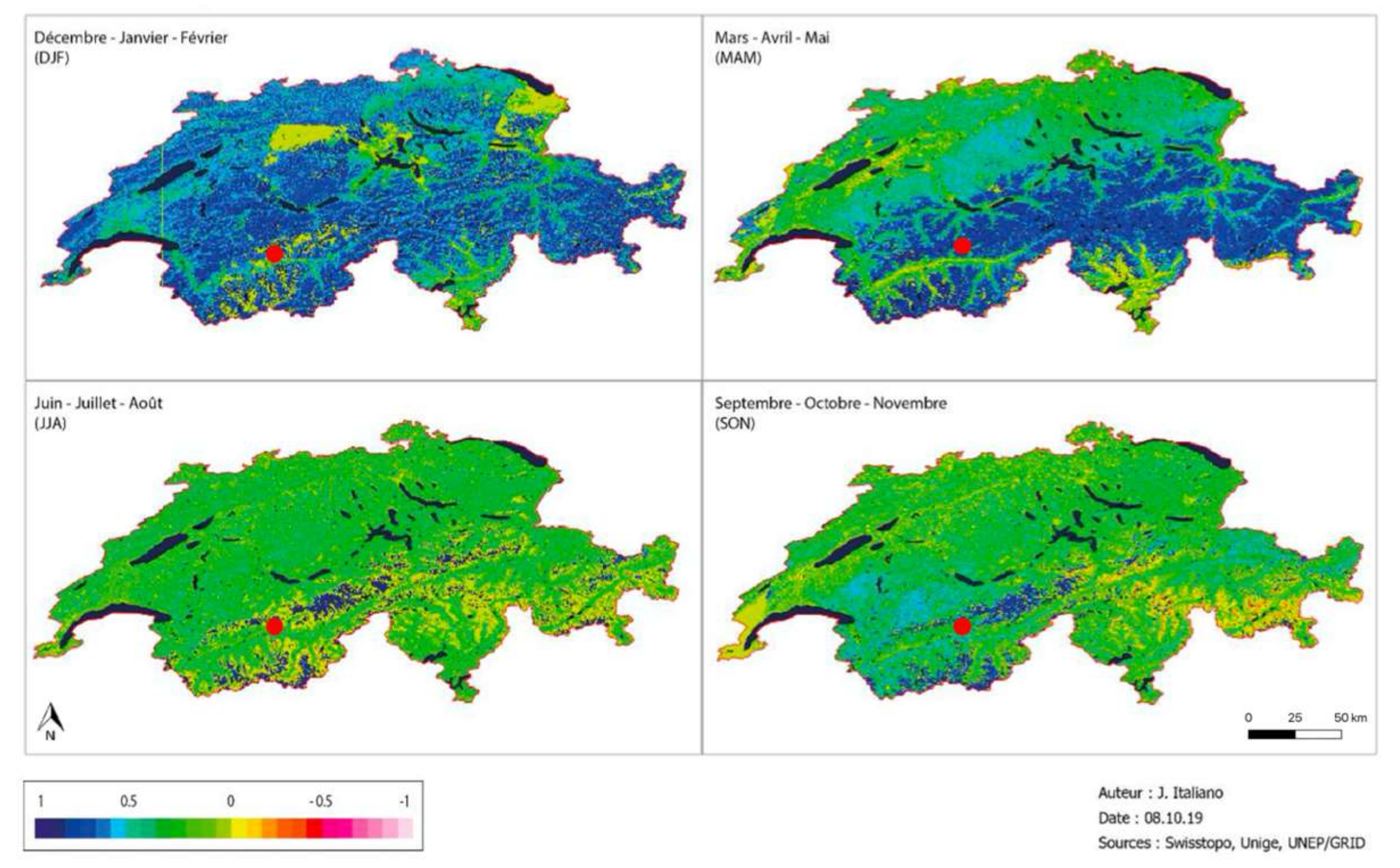
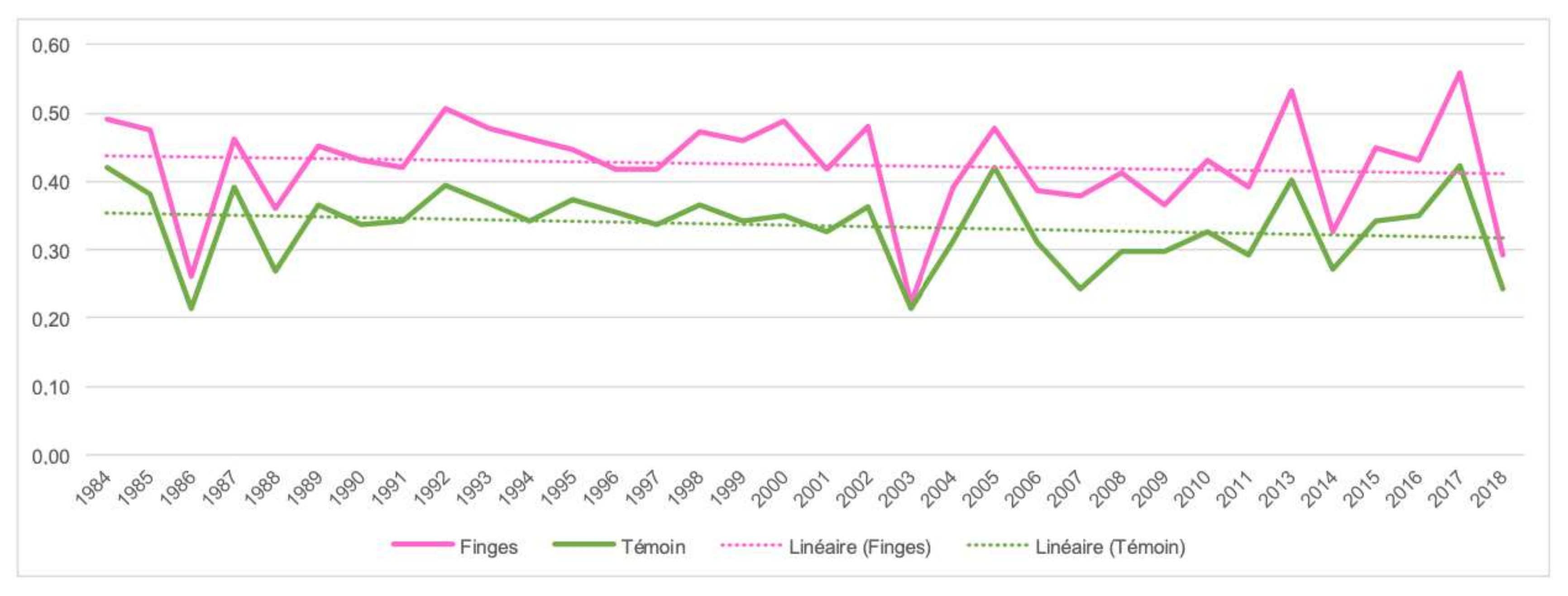
- Honeck, E.; Castello, R.; Chatenoux, B.; Richard, J.-P.; Lehmann, A.; Giuliani, G. From a Vegetation Index to a Sustainable Development Goal Indicator: Forest Trend Monitoring Using Three Decades of Earth Observations across Switzerland. ISPRS Int. J. Geo-Inf. 2018, 7, 455. [Google Scholar] [CrossRef] [Green Version]
- Giuliani, G.; Chatenoux, B.; Benvenuti, A.; Lacroix, P.; Santoro, M.; Mazzetti, P. Monitoring land degradation at national level using satellite Earth Observation time-series data to support SDG15—Exploring the potential of data cube. Big Earth Data 2020, 4, 3–22. [Google Scholar] [CrossRef] [Green Version]
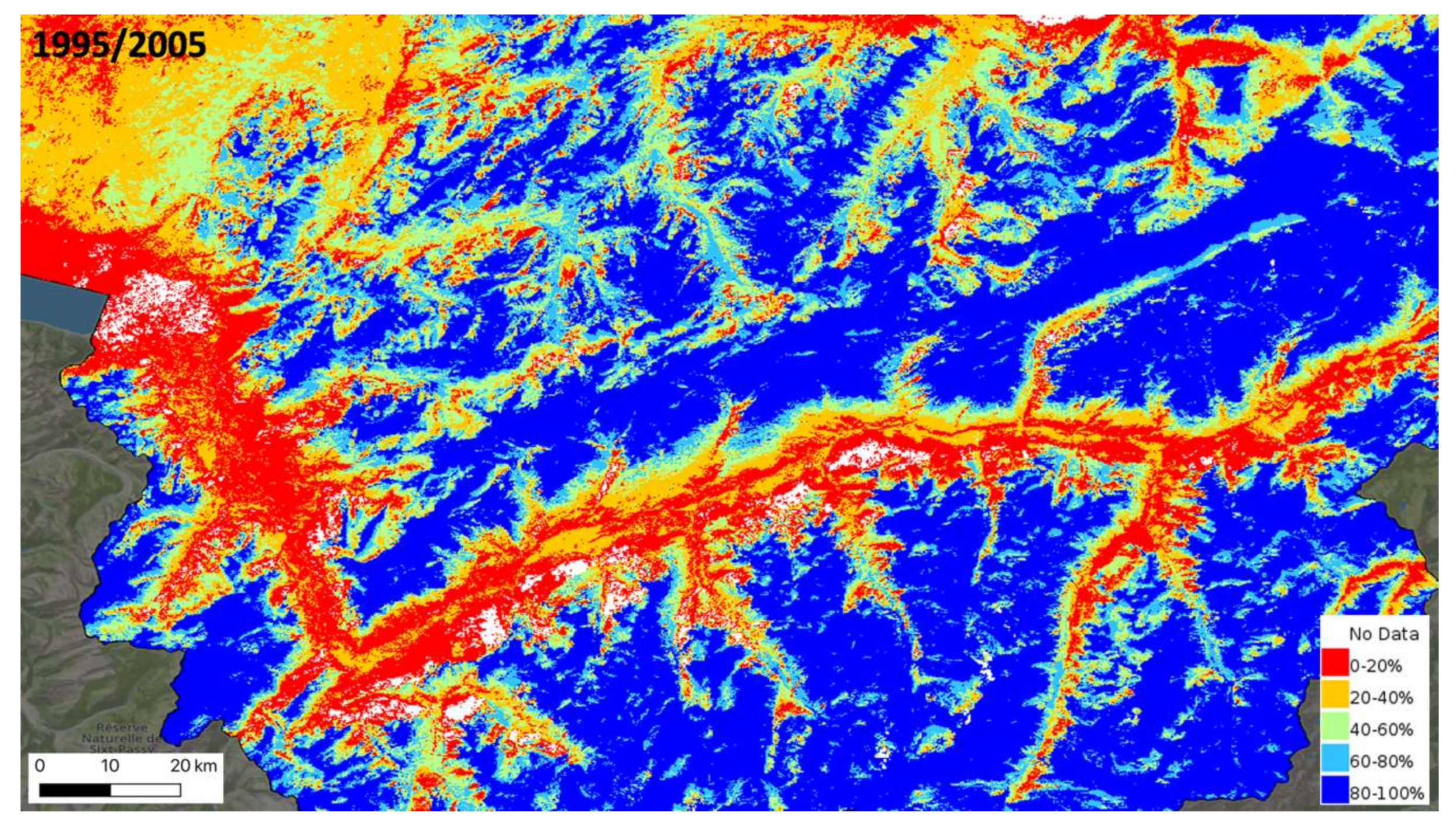
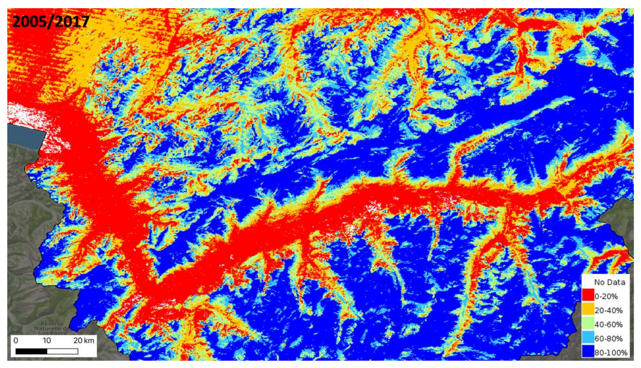
- Poussin, C.; Guigoz, Y.; Palazzi, E.; Terzago, S.; Chatenoux, B.; Giuliani, G. Snow Cover Evolution in the Gran Paradiso National Park, Italian Alps, Using the Earth Observation Data Cube. Data 2019, 4, 138. [Google Scholar] [CrossRef] [Green Version]
- Rizvi, S.R.; Killough, B.; Cherry, A.; Gowda, S. Lessons learned and cost analysis of hosting a full stack Open Data Cube (ODC) application on the Amazon Web Services (AWS). In Proceedings of the IGARSS 2018—2018 IEEE International Geoscience and Remote Sensing Symposium, Valencia, Spain, 22–27 July 2018; pp. 8643–8646. [Google Scholar]
- Perkel, J.M. Why Jupyter is data scientists’ computational notebook of choice. Nature 2018, 563, 145–146. [Google Scholar] [CrossRef] [Green Version]
- Swiss Federal Council. Environment Switzerland 2015; State of the Environment; Swiss Federal Council: Bern, Switzerland, 2015; p. 144. [Google Scholar]
- Beniston, M.; Stoffel, M. Assessing the impacts of climatic change on mountain water resources. Sci. Total Environ. 2013, 493, 1129–1137. [Google Scholar] [CrossRef]
- Loubier, J.-C. Chapter 7—The touristic model of Valais facing climate change: Geoprospective simulations of more environmentally integrated development models. In Ecosystem and Territorial Resilience; Garbolino, E., Voiron-Canicio, C., Eds.; Elsevier: Amsterdam, The Netherlands, 2020; pp. 189–217. ISBN 978-0-12-818215-4. [Google Scholar]
- Hüsler, F.; Jonas, T.; Riffler, M.; Musial, J.P.; Wunderle, S. A satellite-based snow cover climatology (1985–2011) for the European Alps derived from AVHRR data. Cryosphere 2014, 8, 73–90. [Google Scholar] [CrossRef] [Green Version]
- Beniston, M.; Uhlmann, B.; Goyette, S.; Lopez-Moreno, J.I. Will snow-abundant winters still exist in the Swiss Alps in an enhanced greenhouse climate? Int. J. Climatol. 2011, 31, 1257–1263. [Google Scholar] [CrossRef] [Green Version]
- Lehmann, A.; Guigoz, Y.; Ray, N.; Mancosu, E.; Abbaspour, K.C.; Freund, E.R.; Allenbach, K.; Bono, A.D.; Fasel, M.; Gago-Silva, A.; et al. A web platform for landuse, climate, demography, hydrology and beach erosion in the Black Sea catchment. Sci. Data 2017, 4, 170087. [Google Scholar] [CrossRef] [PubMed] [Green Version]
- Frau, L.; Rizvi, S.R.; Chatenoux, B.; Poussin, C.; Richard, J.; Giuliani, G. Snow observations from space: An approach to map snow cover from three decades of Landsat imagery across Switzerland. In Proceedings of the IGARSS 2018—2018 IEEE International Geoscience and Remote Sensing Symposium, Valencia, Spain, 22–27 July 2018; pp. 8663–8666. [Google Scholar]
- Härer, S.; Bernhardt, M.; Siebers, M.; Schulz, K. On the need for a time- and location-dependent estimation of the NDSI threshold value for reducing existing uncertainties in snow cover maps at different scales. Cryosphere 2018, 12, 1629–1642. [Google Scholar] [CrossRef]
- Wang, L.; Qu, J.J.; Hao, X.; Zhu, Q. Sensitivity studies of the moisture effects on MODIS SWIR reflectance and vegetation water indices. Int. J. Remote Sens. 2008, 29, 7065–7075. [Google Scholar] [CrossRef]
- Gao, B. NDWI—A normalized difference water index for remote sensing of vegetation liquid water from space. Remote Sens. Environ. 1996, 58, 257–266. [Google Scholar] [CrossRef]
- Serrano, J.; Shahidian, S.; Marques da Silva, J. Evaluation of Normalized Difference Water Index as a Tool for Monitoring Pasture Seasonal and Inter-Annual Variability in a Mediterranean Agro-Silvo-Pastoral System. Water 2019, 11, 62. [Google Scholar] [CrossRef] [Green Version]
- Gu, Y.; Brown, J.F.; Verdin, J.P.; Wardlow, B. A five-year analysis of MODIS NDVI and NDWI for grassland drought assessment over the central Great Plains of the United States. Geophys. Res. Lett. 2007, 34, L06407. [Google Scholar] [CrossRef] [Green Version]
- Grobicki, A.; MacLeod, F.; Pischke, F. Integrated policies and practices for flood and drought risk management. Water Policy 2015, 17, 180–194. [Google Scholar] [CrossRef]
- Medved-Cvikl, B.; Ceglar, A.; Hofer, B.; Kajfez-Bogataj, L. Benefits of an integrated drought monitoring system in Southeastern Europe. Int. J. Spat. Data Infrastruct. Res. 2012, 7, 225–248. [Google Scholar]
- Ehrbar, D.; Schmocker, L.; Vetsch, D.F.; Boes, R.M. Hydropower Potential in the Periglacial Environment of Switzerland under Climate Change. Sustainability 2018, 10, 2794. [Google Scholar] [CrossRef] [Green Version]
- Savelsberg, J.; Schillinger, M.; Schlecht, I.; Weigt, H. The Impact of Climate Change on Swiss Hydropower. Sustainability 2018, 10, 2541. [Google Scholar] [CrossRef] [Green Version]
- Kreiser, Z.; Killough, B.; Rizvi, S.R. Water across synthetic aperture radar data (WASARD): SAR water body classification for the Open Data Cube. In Proceedings of the IGARSS 2018—2018 IEEE International Geoscience and Remote Sensing Symposium, Valencia, Spain, 22–27 July 2018; pp. 437–440. [Google Scholar]
- Mueller, N.; Lewis, A.; Roberts, D.; Ring, S.; Melrose, R.; Sixsmith, J.; Lymburner, L.; McIntyre, A.; Tan, P.; Curnow, S.; et al. Water observations from space: Mapping surface water from 25 years of Landsat imagery across Australia. Remote Sens. Environ. 2016, 174, 341–352. [Google Scholar] [CrossRef] [Green Version]
- Malenovský, Z.; Rott, H.; Cihlar, J.; Schaepman, M.E.; García-Santos, G.; Fernandes, R.; Berger, M. Sentinels for science: Potential of Sentinel-1, -2, and -3 missions for scientific observations of ocean, cryosphere, and land. Remote Sens. Environ. 2012, 120, 91–101. [Google Scholar] [CrossRef]
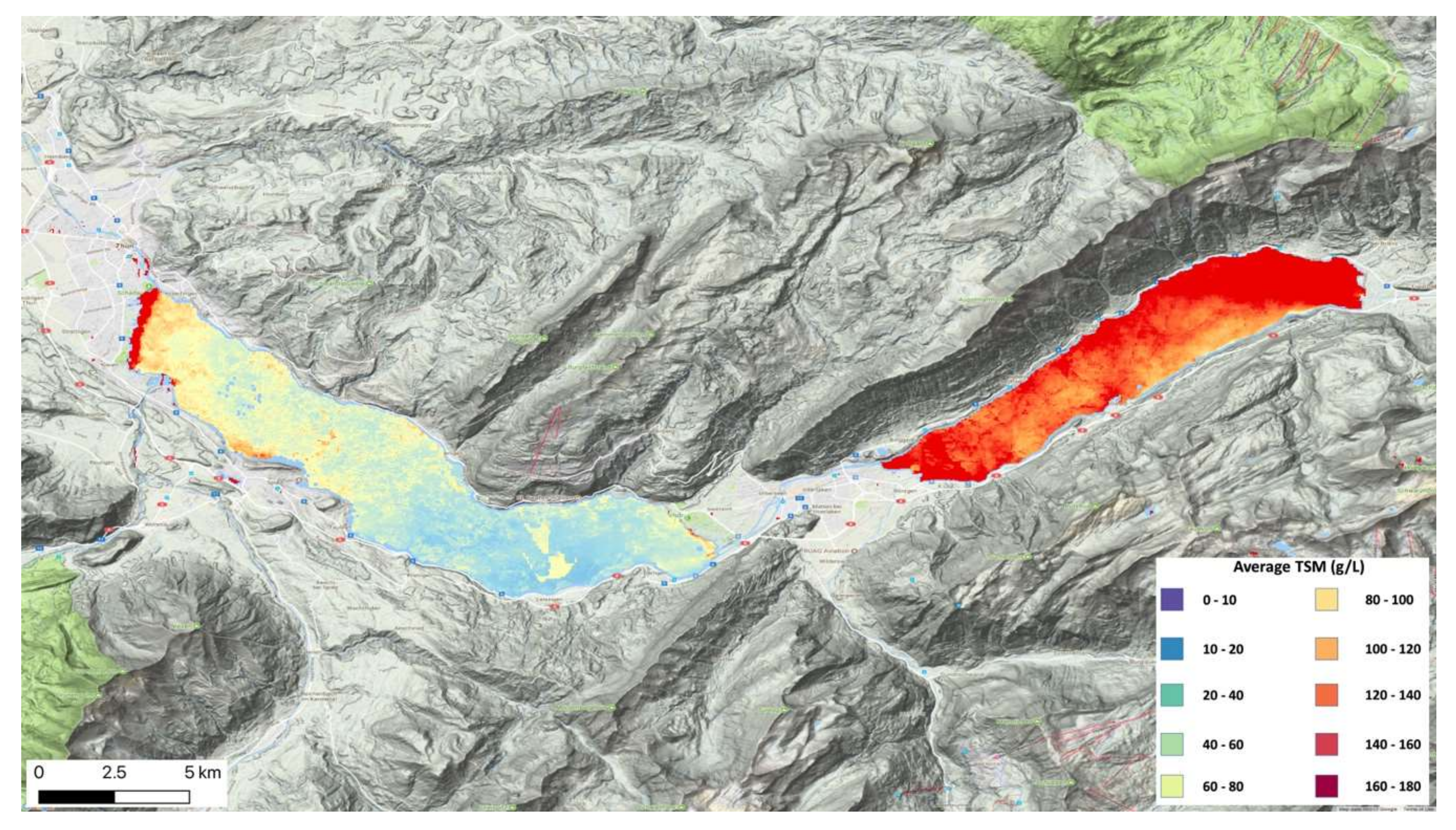
- Thevenon, F.; Wirth, S.B.; Fujak, M.; Poté, J.; Girardclos, S. Human impact on the transport of terrigenous and anthropogenic elements to peri-alpine lakes (Switzerland) over the last decades. Aquat. Sci. 2013, 75, 413–424. [Google Scholar] [CrossRef] [Green Version]
- Guerschman, J.P.; Scarth, P.F.; McVicar, T.R.; Renzullo, L.J.; Malthus, T.J.; Stewart, J.B.; Rickards, J.E.; Trevithick, R. Assessing the effects of site heterogeneity and soil properties when unmixing photosynthetic vegetation, non-photosynthetic vegetation and bare soil fractions from Landsat and MODIS data. Remote Sens. Environ. 2015, 161, 12–26. [Google Scholar] [CrossRef]
- Weber, D.; Schaepman-Strub, G.; Ecker, K. Predicting habitat quality of protected dry grasslands using Landsat NDVI phenology. Ecol. Indic. 2018, 91, 447–460. [Google Scholar] [CrossRef]
- Rouse, J.W., Jr.; Haas, R.H.; Schell, J.A.; Deering, D.W. Monitoring Vegetation Systems in the Great Plains with Erts. NASA Spec. Publ. 1974, 351, 309. [Google Scholar]
- Eastman, J.R.; Sangermano, F.; Machado, E.A.; Rogan, J.; Anyamba, A. Global Trends in Seasonality of Normalized Difference Vegetation Index (NDVI), 1982–2011. Remote Sens. 2013, 5, 4799–4818. [Google Scholar] [CrossRef] [Green Version]
- Huang, S.; Tang, L.; Hupy, J.P.; Wang, Y.; Shao, G. A commentary review on the use of normalized difference vegetation index (NDVI) in the era of popular remote sensing. J. For. Res. 2020. [Google Scholar] [CrossRef]
- Muradyan, V.; Tepanosyan, G.; Asmaryan, S.; Saghatelyan, A.; Dell’Acqua, F. Relationships between NDVI and climatic factors in mountain ecosystems: A case study of Armenia. Remote Sens. Appl. Soc. Environ. 2019, 14, 158–169. [Google Scholar] [CrossRef]
- Vicente-Serrano, S.M.; Martín-Hernández, N.; Reig, F.; Azorin-Molina, C.; Zabalza, J.; Beguería, S.; Domínguez-Castro, F.; Kenawy, A.E.; Peña-Gallardo, M.; Noguera, I.; et al. Vegetation greening in Spain detected from long term data (1981–2015). Int. J. Remote Sens. 2019, 41, 1709–1740. [Google Scholar] [CrossRef]
- Carlson, B.Z.; Corona, M.C.; Dentant, C.; Bonet, R.; Thuiller, W.; Choler, P. Observed long-term greening of alpine vegetation—A case study in the French Alps. Environ. Res. Lett. 2017, 12, 114006. [Google Scholar] [CrossRef]
- Dhu, T.; Dunn, B.; Lewis, B.; Lymburner, L.; Mueller, N.; Telfer, E.; Lewis, A.; McIntyre, A.; Minchin, S.; Phillips, C. Digital earth Australia—Unlocking new value from earth observation data. Big Earth Data 2017, 1, 64–74. [Google Scholar] [CrossRef] [Green Version]
- Yang, C.; Clarke, K.; Shekhar, S.; Tao, C.V. Big Spatiotemporal Data Analytics: A research and innovation frontier. Int. J. Geogr. Inf. Sci. 2020, 34, 1075–1088. [Google Scholar] [CrossRef] [Green Version]
- De Paula, M.D.; Giménez, M.G.; Niamir, A.; Thurner, M.; Hickler, T. Combining European Earth Observation products with Dynamic Global Vegetation Models for estimating Essential Biodiversity Variables. Int. J. Digit. Earth 2019, 13, 262–277. [Google Scholar] [CrossRef]
- McCallum, I.; Montzka, C.; Bayat, B.; Kollet, S.; Kolotii, A.; Kussul, N.; Lavreniuk, M.; Lehmann, A.; Maso, J.; Mazzetti, P.; et al. Developing food, water and energy nexus workflows. Int. J. Digit. Earth 2019, 13, 299–308. [Google Scholar] [CrossRef]
- Giuliani, G.; Chatenoux, B.; Piller, T.; Moser, F.; Lacroix, P. Data Cube on Demand (DCoD): Generating an earth observation Data Cube anywhere in the world. Int. J. Appl. Earth Obs. Geoinf. 2020, 87, 102035. [Google Scholar] [CrossRef]
- Desconnets, J.-C.; Giuliani, G.; Guigoz, Y.; Lacroix, P.; Mlisa, A.; Noort, M.; Ray, N.; Searby, N.D. GEOCAB Portal: A gateway for discovering and accessing capacity building resources in Earth Observation. Int. J. Appl. Earth Obs. Geoinf. 2017, 54, 95–104. [Google Scholar] [CrossRef]
- Giuliani, G.; Lacroix, P.; Guigoz, Y.; Roncella, R.; Bigagli, L.; Santoro, M.; Mazzetti, P.; Nativi, S.; Ray, N.; Lehmann, A. Bringing GEOSS Services into Practice: A Capacity Building Resource on Spatial Data Infrastructures (SDI). Trans. GIS 2016, 21, 811–824. [Google Scholar] [CrossRef]
- Craglia, M.; Hradec, J.; Nativi, S.; Santoro, M. Exploring the depths of the global earth observation system of systems. Big Earth Data 2017, 1, 21–46. [Google Scholar] [CrossRef] [Green Version]
- Craglia, M.; Nativi, S. Mind the Gap: Big Data vs. Interoperability and Reproducibility of Science; Springer: Cham, Switzerland, 2018; ISBN 978-3-319-65632-8. [Google Scholar]
- Nativi, S.; Mazzetti, P.; Craglia, M.; Pirrone, N. The GEOSS solution for enabling data interoperability and integrative research. Environ. Sci. Pollut. Res. 2013, 21, 4177–4192. [Google Scholar] [CrossRef] [PubMed]
- Giuliani, G.; Masó, J.; Mazzetti, P.; Nativi, S.; Zabala, A. Paving the Way to Increased Interoperability of Earth Observations Data Cubes. Data 2019, 4, 113. [Google Scholar] [CrossRef] [Green Version]
- Maso, J.; Zabala, A.; Serral, I.; Pons, X. A Portal Offering Standard Visualization and Analysis on top of an Open Data Cube for Sub-National Regions: The Catalan Data Cube Example. Data 2019, 4, 96. [Google Scholar] [CrossRef] [Green Version]
- Yang, C.; Yu, M.; Li, Y.; Hu, F.; Jiang, Y.; Liu, Q.; Sha, D.; Xu, M.; Gu, J. Big Earth data analytics: A survey. Big Earth Data 2019, 3, 83–107. [Google Scholar] [CrossRef] [Green Version]
- Stall, S.; Yarmey, L.; Cutcher-Gershenfeld, J.; Hanson, B.; Lehnert, K.; Nosek, B.; Parsons, M.; Robinson, E.; Wyborn, L. Make scientific data FAIR. Nature 2019, 570, 27–29. [Google Scholar] [CrossRef] [PubMed] [Green Version]
- Wilkinson, M.D.; Dumontier, M.; Aalbersberg, I.J.; Appleton, G.; Axton, M.; Baak, A.; Blomberg, N.; Boiten, J.-W.; Santos, L.B. da S.; Bourne, P.E.; et al. The FAIR Guiding Principles for scientific data management and stewardship. Sci. Data 2016, 3, 160018. [Google Scholar] [CrossRef] [PubMed] [Green Version]
- Chaves, M.E.D.; Picoli, M.C.A.; Sanches, I.D. Recent Applications of Landsat 8/OLI and Sentinel-2/MSI for Land Use and Land Cover Mapping: A Systematic Review. Remote Sens. 2020, 12, 3062. [Google Scholar] [CrossRef]
- Lucas, R.; Mueller, N.; Siggins, A.; Owers, C.; Clewley, D.; Bunting, P.; Kooymans, C.; Tissott, B.; Lewis, B.; Lymburner, L.; et al. Land Cover Mapping using Digital Earth Australia. Data 2019, 4, 143. [Google Scholar] [CrossRef] [Green Version]


| Class | ECV | Remote Sensing | Spatial Scale | Temporal Scale | |
|---|---|---|---|---|---|
| Atmosphere | Surface | Precipitation | Y [53] | L-N-R-G | H-D-W-M-S-A |
| Pressure (surface) | N | L-N-R-G | H-D-W-M-S-A | ||
| Surface Radiation Budget | Y [54] | R-G | H-D-W-M-S-A | ||
| Surface Wind Speed and direction | Y [55] | L-N-R-G | H-D-W-M-S-A | ||
| Temperature (near surface) | Y [56] | L-N-R-G | H-D-W-M-S-A | ||
| Water Vapor (surface) | Y [55] | R-G | H-D-W-M-S-A | ||
| Upper Atmosphere | Earth Radiation Budget | Y [57] | G | W-M-S-A | |
| Lighting | Y [58] | G | W-M-S-A | ||
| Temperature (upper air) | P [59] | R-G | H-D-W-M-S-A | ||
| Water Vapor (upper air) | P [60] | R-G | H-D-W-M-S-A | ||
| Cloud properties | P [61] | R-G | H-D-W-M-S-A | ||
| Wind speed and direction (upper air) | Y [55] | L-N-R-G | H-D-W-M-S-A | ||
| Atmospheric Composition | Aerosols properties | P [62] | L-N-R-G | H-D-W-M-S-A | |
| Carbon Dioxide, Methane and other Greenhouse gases | P [63] | L-N-R-G | H-D-W-M-S-A | ||
| Ozone | Y [64] | L-N-R-G | H-D-W-M-S-A | ||
| Precursors (supporting the Aerosol and Ozone ECVs) | P [65] | L-N-R-G | H-D-W-M-S-A | ||
| Land | Hydrosphere | River Discharge | N | L-N-R-G | H-D-W-M-S-A |
| Groundwater | P [66] | R-G | H-D-W-M-S-A | ||
| Lakes | Y [67] | L-N-R-G | H-D-W-M-S-A | ||
| Soil Moisture | P [68] | L-N-R-G | H-D-W-M-S-A | ||
| Cryosphere | Snow | Y [69] | L-N-R-G | H-D-W-M-S-A | |
| Glaciers | Y [70] | L-N-R-G | M-S-A | ||
| Ice Sheets and ice shelves | P [70] | L-N-R-G | M-S-A | ||
| Permafrost | P [71] | L-N-R-G | M-S-A | ||
| Biosphere | Albedo | Y [72] | R-G | H-D-W-M-S-A | |
| Land cover | Y [73] | L-N-R-G | A | ||
| Fraction of Absorbed Photosynthetically Active Radiation (FAPAR) | P [74] | L-N-R-G | W-M-S-A | ||
| Leaf Area Index (LAI) | P [74] | L-N-R-G | W-M-S-A | ||
| Above-ground biomass | P [75] | L-N-R-G | M-S-A | ||
| Soil Carbon | P [76] | L-N-R-G | M-S-A | ||
| Land Surface Temperature | Y [77] | L-N-R-G | H-D-W-M-S-A | ||
| Fire | Y [78] | L-N-R-G | H-D-W-M-S-A | ||
| Evaporation from land | P [79] | L-N-R-G | H-D-W-M-S-A | ||
| Anthroposphere | Anthropogenic Greenhouse Gas Fluxes | N | L-N-R-G | H-D-W-M-S-A | |
| Anthropogenic Water Use | N | L-N-R-G | H-D-W-M-S-A | ||
| Ocean | Physical | Ocean Surface Heat Flux | P [80] | R-G | H-D-W-M-S-A |
| Sea Ice | Y [81] | R-G | W-M-S-A | ||
| Sea Level | P [82] | R-G | H-D-W-M-S-A | ||
| Sea State | N | R-G | H-D-W-M-S-A | ||
| Sea Surface Salinity | Y [83] | R-G | H-D-W-M-S-A | ||
| Sea Surface Temperature | Y [84] | R-G | H-D-W-M-S-A | ||
| Subsurface Currents | N | R-G | H-D-W-M-S-A | ||
| Surface Currents | P [85] | R-G | H-D-W-M-S-A | ||
| Surface Stress | N | R-G | H-D-W-M-S-A | ||
| Biogeochemical | Inorganic Carbon | N | R-G | W-M-S-A | |
| Nitrous Oxide | N | R-G | W-M-S-A | ||
| Nutrients | P [86] | R-G | D-W-M-S-A | ||
| Ocean Colour | Y [87] | R-G | D-W-M-S-A | ||
| Oxygen | N | L-N-R-G | H-D-W-M-S-A | ||
| Transient Tracers | N | L-N-R-G | H-D-W-M-S-A | ||
| Biological/Ecosystems | Marine Habitats Properties | P [88] | R-G | M-S-A | |
| Plankton | P [89] | L-N-R-G | H-D-W-M-S-A |
| Class | EBV | Remote Sensing | Spatial Scale | Temporal Scale |
|---|---|---|---|---|
| Genetic composition | Co-ancestry | N | L | M-S-A |
| Allelic diversity | N | L-N-R-G | M-S-A | |
| Population genetic differentiation | P | L-N-R-G | M-S-A | |
| Breed and variety diversity | N | L-N-R-G | M-S-A | |
| Species population | Species distribution | P | L-N-R-G | M-S-A |
| Population abundance | P | L-N-R-G | M-S-A | |
| Population structure by age/size class | P | L-N-R-G | M-S-A | |
| Species traits | Phenology | P | L-N-R-G | W-M-S-A |
| Morphology | P | L-N-R-G | M-S-A | |
| Reproduction | N | L-N-R-G | W-M-S-A | |
| Physiology | N | L-N-R-G | W-M-S-A | |
| Movement | N | L-N-R-G | W-M-S-A | |
| Community composition | Taxonomic diversity | P | L-N-R-G | M-S-A |
| Species interactions | N | L-N-R-G | M-S-A | |
| Ecosystem functions | Net primary productivity | P | L-N-R-G | H-D-W-M-S-A |
| Secondary productivity | N | L-N-R-G | H-D-W-M-S-A | |
| Nutrient retention | N | L-N-R-G | M-S-A | |
| Disturbance regime | Y | L-N-R-G | M-S-A | |
| Ecosystem structure | Habitat structure | P | L-N-R-G | M-S-A |
| Ecosystem extent and fragmentation | P | L-N-R-G | M-S-A | |
| Ecosystem composition by functional type | P | L-N-R-G | M-S-A |
| Class | EWV | Remote Sensing | Spatial Scale | Temporal Scale |
|---|---|---|---|---|
| Primary | Precipitation | Y [53] | L-N-R-G | H-D-W-M-S-A |
| Evaporation and Evapotranspiration | P [79] | L-N-R-G | H-D-W-M-S-A | |
| Snow Cover (and Depth, Freeze Thaw Margins) | P [100] | L-N-R-G | H-D-W-M-S-A | |
| Soil moisture/temperature | Y [56] | L-N-R-G | H-D-W-M-S-A | |
| Groundwater | P [101] | R-G | H-D-W-M-S-A | |
| Runoff/Streamflow/River Discharge | N | L-N-R-G | H-D-W-M-S-A | |
| Lakes/Reservoir levels and Aquifer volumetric change | P [67] | L-N-R-G | H-D-W-M-S-A | |
| Water Quality | P [102] | L-N-R-G | H-D-W-M-S-A | |
| Water use/demand | N | L-N-R-G | D-W-M-S-A | |
| Glaciers/ice sheets | Y [70] | R-G | M-S-A | |
| Supplementary | Surface meteorology | P [55] | L-N-R-G | H-D-W-M-S-A |
| Surface and atmospheric radiation budget | P [57] | R-G | H-D-W-M-S-A | |
| Cloud and aerosols | P [103] | L-N-R-G | H-D-W-M-S-A | |
| Land Cover and vegetation/Land use | Y [73] | L-N-R-G | M-S-A | |
| Permafrost | P [71] | L-N-R-G | W-M-S-A | |
| Elevation/topography and geological stratification | P [104] | L-N-R-G | A |
Publisher’s Note: MDPI stays neutral with regard to jurisdictional claims in published maps and institutional affiliations. |
© 2020 by the authors. Licensee MDPI, Basel, Switzerland. This article is an open access article distributed under the terms and conditions of the Creative Commons Attribution (CC BY) license (http://creativecommons.org/licenses/by/4.0/).
Share and Cite
Giuliani, G.; Egger, E.; Italiano, J.; Poussin, C.; Richard, J.-P.; Chatenoux, B. Essential Variables for Environmental Monitoring: What Are the Possible Contributions of Earth Observation Data Cubes? Data 2020, 5, 100. https://doi.org/10.3390/data5040100
Giuliani G, Egger E, Italiano J, Poussin C, Richard J-P, Chatenoux B. Essential Variables for Environmental Monitoring: What Are the Possible Contributions of Earth Observation Data Cubes? Data. 2020; 5(4):100. https://doi.org/10.3390/data5040100
Chicago/Turabian StyleGiuliani, Gregory, Elvire Egger, Julie Italiano, Charlotte Poussin, Jean-Philippe Richard, and Bruno Chatenoux. 2020. "Essential Variables for Environmental Monitoring: What Are the Possible Contributions of Earth Observation Data Cubes?" Data 5, no. 4: 100. https://doi.org/10.3390/data5040100